Showing 2181 items
matching a. w. a. s.
-
 Kiewa Valley Historical Society
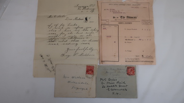
Letters x4 - Re Mrs Stiles
The Advocate was the Catholic newspaper of Victoria. The correspondence is in regard to payment and receipt of the newspapers.4 letters, 2 with envelopes. Chronological order: 1. 11 Jan 1927. From George W. Maddison, Tawonga P. O. Via Dederang to Mrs E. Stiles re money for 'Leader'. 2. 5th Apr. 1928. From Melbourne to Mrs Stiles, Melbourne re Account or "Advocate' 3. late July 1928. From Miss Mary Hessian, Mongans Bridge. Via Wodonga to Mrs Stiles re 'advocate' 4. 28th Jan. 1929 From Chas Martin to Mrs Wallace Bonnie Brae, Bruarong re Mrs Stiles papers. Envelopes: 1. (letter 3)Mrs Stiles c/- Miss Reid 26 Hoddle St. Elsternwick S-4 and in pencil Miss Mary Hessian, Mongan's Bridge, Huon via Wodonga 2. (letter 4) Mrs Wallace, Wallacedale, Kergunyah.mrs e. stiles, mary hessian, george w. maddison, mr wallace, 'advocate' newspaper, chas martin -
 Warrnambool and District Historical Society Inc.
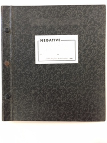
Photo, Negatives Pioneers of Warrnambool & District board, 1975
The following extract written by Karen Tyers Warrnambool Family history group explains the journey and background of the Warrnambool Pioneer Board. Warrnambool is fortunate to have a photographic record of some of its pioneers. They are commemorated on the Pioneers’ Board. The Pioneers’ Board with its elaborate frame measures approximately 2 metres by 3 metres and holds 204 photographs of Warrnambool’s early pioneers. In 1907 Edward Vidler, secretary of the Warrnambool & District Progress League and Chamber of Commerce and Industry, invited descendants of those who arrived in Warrnambool before 1860 to send photographs of their pioneer ancestors to commemorate the Diamond Jubilee of Warrnambool’s foundation in 1847. A charge of £1 for each photograph was set. Lillian Foyle of Foyle’s photographic studio, was engaged to colour the photographs and undertake the associated artwork. By December 1907 the honour board was on exhibition in Bernard’s Gallery, Melbourne. Unfortunately Vidler left Warrnambool in 1907 with the honour board expenses unpaid. The Progress League refused to take responsibility for the debt and the honour board remained with Foyle’s Studio for 17 years. In 1922 subscriptions were called for and £43 16s 6d was acknowledged. After a final determined effort was made in 1924, the £100 debt was collected and Charles Foyle, Lillian’s brother, accepted settlement of the debt. On 2 May 1924 the honour board was moved from Foyle’s Studio to the Art Gallery. For many years the honour board was in the entrance passage to the public library. After the library was demolished in 1975 the pictures were removed to the Art Gallery where it was restored by the Director of the Art Gallery, Jack Welsh. The board was later stored in an empty front room at Murweh and the dismantled frame stored in an outbuilding. By 1982 the honour board was in the foyer of the City Council offices. During the renovations of the interior of the council offices in 1997 the honour board was moved to the library where it remained until moved to HeritageWorks in March 2014. For a full list of names go to http://www.warrnamboolhistory.org.au/warrnambool-history/pioneers-board/ The Warrnambool pioneer Board is one of those rare items which can claim significance on most if not all of the primary and comparative significance criteria. As a collection of early pioneers in the district it provides a valuable resource for historians and researchers. It gives light to a social scene in the district much of which can be verified from diaries and other items held by the historical society and also available on websites such as Trove. It has relevance to this day with many family historians enquiring of people included on the board. The collation of the board is a story of great interest in itself. While there are images of 204 men on the board the only reference to a woman is Lillian Foyle the artist who was responsible for much of the artistic work on the board. It compares well in size and quality with a number of montages, and collations of images from around the state of Victoria. It is by no means a complete list of pioneers of the district but there are many well- known ones included. They come from a wide range of backgrounds and as such presents a cross section of our earliest settlers in the district from 1840's to 1860’s.Cardboard folder with black and grey mottled cover with 3 metal studs along spine and white paper label with the word negative printed in black on front cover. Inside is a printed index of pioneers with reference relating to board number and negative number. There are three loose strips of negatives and 20 pages with pockets to hold strips of negatives. Up to page 13 have negatives strips inserted. There are 15 large and one small print of some of the pioneers from the board.This negative album was prepared by John A Welsh MBE JP Dip M Eng Director Warrnambool Art Gallery 1/7/1975 to 11/12/1977.There are a number of grey lead notations possibly corrections against some of the names in the index.warrnambool, warrnambool pioneer board, jack welsh, warrnambool art gallery, pioneers of warrnambool, foyles photography, lillian foyle, bernard framers, w mcaree, -
 Warrnambool and District Historical Society Inc.
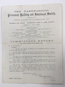
Balance Sheet, Warrnambool Permanent Building and Investment Society 1872, 1872
The Warrnambool permanent Building and Investment Society was established in May 1869. It relied on investors buying shares in the society, thereby providing the funds which were available to be borrowed to use in the building of houses. A considerable number of houses in Warrnambool would have been built using this scheme. The stated trustees in 1872 were Samuel Macgregor, C A Cramer, James Astley Bromfield, and the committee comprised of James Hider, W. W. Jamieson, James Coulstock, Archibald MacFarlane, Robert Newton, David Evans, NT C Stelling and W Jones. The bankers were the national Bank of Australasia. It had some difficulties in the 1870’s but was still operating well into the 1930’s where it again was not putting through the volume of business compatible with its resources and it had been found necessary to pay off a considerable number of fixed deposits and Investors’ shares. There is little mention of it after the mid 1930’s. This document provides details of an organization which operated in Warrnambool for over 60 years and proved beneficial to homebuilders and investors alike. It also has a number of well- known local names listed in their positions of operating the building society.Cream watermarked paper folded to four pages. Title on front cover with letter to shareholders printed below for the year ending 30th April 1872. Page three has balance sheet of the Warrnambool Permanent Building & investment Society. Second and fourth pages are blank. Signed in print by James Hider President, Henry T Read secretary.warrnambool permanent building and investment society, warrnambool, warrnambool 1872, -
 Warrnambool and District Historical Society Inc.
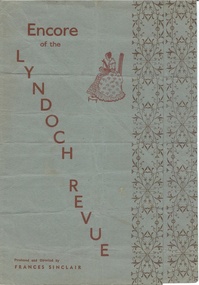
Document, Lyndoch Revue, C1950
This is a program for a local theatrical performance. It was produced and directed by Frances Sinclair and contains a number of dance and musical items. There are a number of local Warrnambool names among the performers such as K T Swinton, Rex Fotheringham, Mavis MacDonald, Miss Rooney, W Goodall, John Reid, George and June Philpot. The dancers ranged from tiny tots, Petite ballerinas, Corp de ballet to the belles De Paris. Some of the other items on the program are the Scottish Samba, Tut and Khamen and Fiesta in Granada by Ferdinande Del Campo Caravani111 and Monty Bellow the Atomic Bull & Co which would suggest that it around the time of the Atomic testing in the Montebello Islands in the 1950’s. A program which shows the artistic side to the city and associated humour and talent. It has a large number of names of those involved in the production and performance and would be typical of concerts performed around the country at that time. It predates the Warrnambool Theatre company which commenced production of musical items in the 1960’s.Dusty blue paper with red text running at an angle down the front cover. Diagram of a lady sitting and stitching. Brown floral border down the edge of the front and middle page. Back cover is plain apart from printer’s name on bottom centre.Kaye & Sons Printers Warrnambool. -
 Warrnambool and District Historical Society Inc.
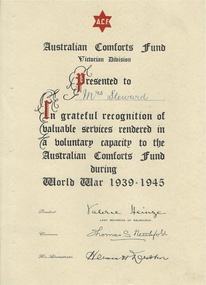
Document, Australian Comfort Fund Mrs Steward, C1946
... of Melbourne. Thomas S Neu*tefold, Hermen W *ohn, On front of grey... S Neu*tefold, Hermen W *ohn, On front of grey folder "Mrs ...The Australian Comforts Fund was formed during the first World War and was an amalgamation of various organisations which were sending items of comfort such as toiletries, clothing and food to Australian troops who were fighting overseas. It ceased its work and was dissolved in 1920 at the ceasation of the war but was started again to continue the same work in 1939.In Australia it rivalled the work of the red Cross and many of the volunteers involved were women. As well as making and providing items themselves there was major fundraising to purchase further items. Over the course of the war they provided over 1.5 million hampers. This certificate was presented to Mrs Steward for valuable services rendered to the Australian Comforts Fund during World War 1939-1945. The Australian Comforts fund was wound up in June 1946.This certificate recognises the work of one of our residents to a fund which was Australia wide and would have been one of numerous certificates presented around the country. The Australian Comforts fund was an organisation with which numerous people would have been affiliated and which also assisted many soldiers over the years. Cream certificate with black text, highlighted with red. The name Mrs Steward has been written in in blue ink. In comes enclosed in a dark grey soft card folder.Mrs Steward. Signed Valerie Heinze, Lady mayoress of Melbourne. Thomas S Neu*tefold, Hermen W *ohn, On front of grey folder "Mrs Steward Warrnambool.warrnambool, warrnambool history, australian comforts fund, mrs steward warrnambool -
 Warrnambool and District Historical Society Inc.
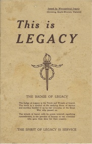
Booklet, This is Legacy, 1947
Legacy had its origins in the aftermath of the first World War. General Sir John Gellibrand in 1923 in Hobart established the Remembrance Club which was to assist returned soldiers. He convinced Stanley Savige a returned soldier who had served with Gellibrand to set up a similar group in Melbourne. The Melbourne group was established at Anzac House shortly after. Initially looking to the needs of returned soldiers, by 1925 they had included the care of deceased soldiers’ widows and children a task which continues to the present day. It is an entirely honorary organization. It lists among its objectives as doing all for the children which the father would have been glad to see done for them. The Warrnambool club was founded in 1947 and this booklet lists the office bearers as Chas Watts, I Buzzard, D B de Beaurepaire, A K Browne R Potter, N K Morris, P H Allen, W J Tolmie, J Paterson, b C Stronach, L G Stevens, T b Patrick, R S Robinson, J O Tait. The Warrnambool region covered from Port Campbell north to Pormborneit, through Darlington and Woorndoo and across to Broadwater and Codrington and Port Fairy in the west. In 1947 they had 200 wards under their care. This booklet has as its centre pages two photographs depicting children and adults and the captions to raise £10000 towards their work and also to build a holiday camp on beach frontage already approved by the Warrnambool City Council.This booklet has historical and social significance as it shows the endeavor of the people of the district to care for those affected by war, in the district and records the names of the first people involved in working with Legacy in Warrnambool .Dark cream coloured soft card cover with brown text. Title is in larger text with the Legacy emblem in the centre of the front cover. The back cover has the poem, Flanders Field and the legacy response. Eight pages which has text and some photographs. A list of Warrnambool office bearers is on the inside back cover. *Printers Geelong. Issued by Warrnambool Legacy. warrnambool, warrnambool legacy warrnambool legacy 1947 -
 Warrnambool and District Historical Society Inc.
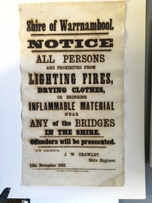
Document, Shire of Warrnambool Fire - Washing-Bridge 1882, 1882
This notice relates to the prohibition of lighting fires,drying clothes or bringing inflamable material near any of the bridges in the shire. Offenders will be prosecuted. With a date of 1882 and the fact that bridges were mostly made of wood, it would have been of concern that the destruction of bridges was not only of great inconvenience but also of considerable expense. But the reality of bridges providing shelter and warmth in the colder months and the ensuring fires and burnt bridges has more than likely precipitated this notice. J W Crawley was shire engineer from 1876 until 1895 and for 10 of those years he trained his son J W Crawley who succeeded his father and served in the position for 40 years.He in turn was succeeded by his son Rolf Crawley in 1935. In 1963 the bridge over the Hopkins Falls at Wangoom was named the Crawley bridge in honour of service to the Shire of Warrnambool by members of the Crawley family. The Shire of Warrnambool was proclaimed in 1863 and covered an area of over 600 square miles. Much of it was incorporated into the Moyne Shire in the 1990's with some being included into the boundaries of City of Warrnambool. This banner is an interesting piece of history. It shows the issues confronting early settlers such as shelter and the chores of daily life but also the importance placed on infrastructure which was slowly taking place around the district. It was in the era of drainage and roadworks and hence bridges were an important part of that infrastructure. The name J W Crawley is one of importance in the Warrnambool district for his service over many years. Rectangular piece of cloth printed in black ink. The back is plain.Shire of Warrnambool By order of J W Crawley Shire Engineer, 13th November 1882. Thos Smith gas Printing Works Koroit Street Warrnambool.warrnambool, shire of warrnambool, bridges of warrnambool shire, j w crawley, warrnambool shire engineer, crawleys of warrnambool -
 Warrnambool and District Historical Society Inc.
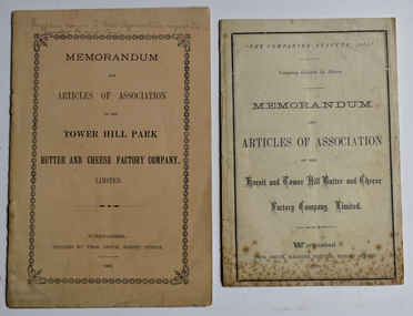
Booklet - Memorandum and Articles of Association 003048.1 Tower Hill Park Butter and Cheese Factory Company Ltd; 003048.2 Koroit and Tower Hill Butter and Cheese Factory Company Ltd, Thomas Smith Printer, 003048.1 1893; 003048.2 1888
These booklets document the formation and the aims of two early dairy factories in the Koroit and Tower Hill area. These factories later became part of the Koroit FactoryThese two memorandums of association document the formation of two early butter and cheese factories in the Koroit and Tower Hill area, listing the first directors. A meeting at the Koroit Town Hall on May 23, 1888, unanimously decided to form the Koroit and Tower Hill Butter Factory coy. Ltd. Mr W J Anderson started the movement to establish a butter factory to suit the convenience of the share farmers of the Tower Hill Park estate in the early 1890's. Both of these factories were ultimately bought out by the Koroit Factory.003048.1 10 page small buff coloured booklet dated 1893 with pencilled note "Supplier names to Dept. Agriculture requesting Pamphlets be sent them" 003048.2 8 page cream coloured booklet dated 1888003048.1 Memorandum and Articles of Association of the Tower Hill Park Butter and Cheese Factory company, Limited. Warrnambool Printed by Thos. Smith, Koroit Street. 1893 003048.2 "The Companies' Statute, 1864" company limited by Shares Memorandum and Articles of Association of the Koroit and Tower Hill Butter and Cheese Factory, Limited. ~ Warrnambool: Thos. Smith, Machine Printer, Koroit Street, 1888memorandum and articles of association, butter and cheese factory, tower hill park butter and cheese factory, koroit and tower hill butter and cheese factory, thomas smith printer, dairying factory, john wilson anderson, john campbell jnr., joseph lamb wall, thomas gleeson, john quirk, michael hally, robert kerr, william crowe, james young, patrick mcgrath, richard skilbeck, peter mcvicar, tower hill park, illowa -
 Warrnambool and District Historical Society Inc.
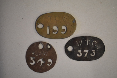
Stencils x 3
... on the left side. .2 Circular metal with 549 cut out of metal and S....1 WTC Old catalogue number on rear 437 .2 S of W Old... stencils .1 WTC Old catalogue number on rear 437 .2 S of W Old ...Stencils were used to mark produce before it went to markets and/or in transit. Produce such as bales of wool, dairy and fresh produce were so marked and the account credited to the relevant producer. The origins and provenance of the stencils is not known at this time.These stencils have no known provenance but have interpretive interest and significance..1 Oval metal stencil with the number 373 cut out of the metal and with WTC engraved above it. Circular hole in the metal on the left side. .2 Circular metal with 549 cut out of metal and S of W engraved above. One large circle and two smaller circles also cut out of the metal. .3 Oval metal stencil with the numbers 199 cut out of metal and TCW engraved above it. Circular hole has been cut out on the left..1 WTC Old catalogue number on rear 437 .2 S of W Old catalogue number on rear 442 .3 TCW. Old catalogue number on rear.433warrnambool, metal stencils, farm stencils -
 Warrnambool and District Historical Society Inc.
Documents, Childer's Cove, 1920-1940's
Childers Cove is situated about 15 ks east of Warrnambool in the area known as Mepunga. It is named after the shipwreck of 'The Children.The documents relate to the running of the Childer's Cove Progress Association. There are a number of social activities including gymkhanas, racing meetings, making of roads and improving with planting trees There are many names which are still familiar with the area nearly 100 years later, including Wallace, McDowall, Burleigh, Murnane, Bonnett, Abraham Laidlaw Keogh Holloway and Palmer. Some of the meetings were held at the Mepunga South School with others held at Eckers Hotel Warrnambool and some at the race course. Fundraising events were held also from athletic meetings and district school children's races. This collection of papers is representative of many small communities around Australia where people came together and worked to improve their community facilities. It therefore has strong social and historic significance.This is a collection of papers most of which relate to the Childer's Cove Progress Association. Included are: .1 Minute Book/ Exercise book Childer's Cove Progress Association.May 1928-1932 .2 Minute Book/ Exercise book Childer's Cove Progress Association. 1924-1926 .3 Letter from Warrnambool Football Club 1930. .4 Account Archibald MacFarlane & Co March 1929 .5 Western District Racing Association Oct 1929. .6 Federal Taxation Dep Re Entertainment Tax 11/02/1930 .7 Chief Secretary Office re Racing Permits March 1923. .8-.9 Warrnambool Standard Invoices Jan 1930's .10 Archibald MacFarlane & Co Jan 1930. .11 Chief Office for Stamp Duties 12/02/1928 .12 Flyer - Childer's Cove Progress Association April 17 1926. .13 Flyer- Monster Gymkhana 12/02/ 1927. .14 Handwritten Invoice Charles Palmer Nov 1929. .15 Cheque Book Childer's Cove Progress Association 1929-31. .16 Deposit Book Childer's Cove Progress Association 1932-1942 .17 Bundle of invoices. .1 C J Caddy & Sons.2 Western Ice & Ice Products .3 Department of Lands & Survey Aug 1923 .4 J S Tait re Licence April 1924 .5 Warrnambool Standard31/12/1923 .6 Warrnambool Standard 31/03/1924 .7 Devenish & Co August 1924 .8 Warrnambool Standard 31/06/1924 H J Paynter & Co 03/05/1924 .10 Chief Secretary's Office Melbourne 01/05/1924 with receipt. .11 Permit for a race meeting April 19 1924 .12 Commonwealth of Australia Entertainment Tax 06/09/1924.13 Commonwealth of Australia Entertainment Notice 27/08/01924 .14 Commonwealth of Australia Entertainment Tax notice 12/08/1924 .18 William Ardlie handwritten letter 28/03/1928 .19 Envelope Addressed to W R Abrahams .20 Final notice Handwritten Charles Palmer Jan 1930. .21 Balance Sheet Childer's Cove Racing Club 18/03/1929 .22 H J Paynter & Co Account and receipt 25/02/1930. .23 Raglan Parade Timber Yards Alex Donaldson Feb 1930. .24 The School Paper Feb 1964 No 741 childer's cove, mepunga, childer's cove progress association -
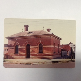
 Port of Echuca
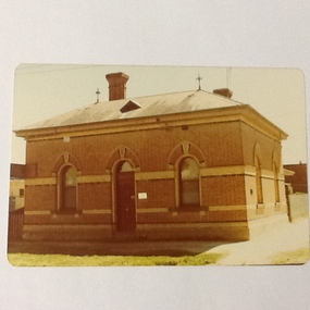
Colour photograph, Approx 1979
... on goods transported from N. S. W. to Victoria. The taxes were ...Customs building: built 1884 to handle goods entering Victoria up to 1901. Building classified B by National Trust.Customs houses, of similar design, were built along the Murray river to collect taxes on goods transported from N. S. W. to Victoria. The taxes were collected up until Federation in 1901. The Victorian railways used it as an office until about the 1960 when it became a private dwelling. The Customs House at Echuca is now owned by The Port of Echuca and has been used to house a wine tasting businesses, cafe and local produce retail and art gallery.Colour photograph of Customs House at Echuca port.In ink on reverse: "8A"customs house, echuca, echuca historical buildings, echuca, port of (customs history) -
 Port of Echuca
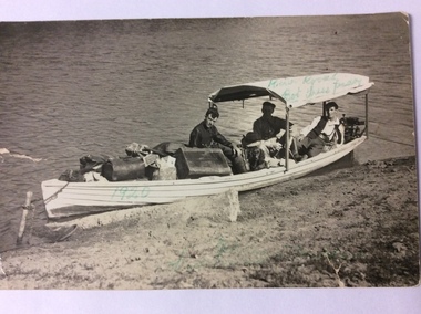
Postcard, February 1920
This is a photograph of three men in a heavily laden boat. The boat is tied up to a stick inserted into the bank. There is a black cocker spaniel dog also in the boat. The man in the middle back is believed to be John Trestrail Freeman. The card has been addressed to his wife. Dolly Freeman née Dolly Dean. The other two men , Bot and Paddy cannot be identified. The men are obviously travelling up the river. There is a motor on the back of the boat. The luggage includes a Gladstone bag, suit cases and boxes, indicating they have been travelling a long distance.This photograph is significant because it shows the type of transport available in the 1920's. Also it shows the conditions the three men travelled in. The boat was small, heavily laden with a simple motor. River traffic in 1920 would have been sparse. Also a journey from Echuca to Mildura would have taken weeks to complete.A rectangular black and white postcard showing three men and a dog in a heavily laden boat, which is tied up to the bank.On the back is printed W. GRIMWOOD/ POSTCARD/CORRESPONDENCE/ ADDRESS ONLY/KODAK AUSTRALIA . Handwritten in ink on the back are the words "To Doll from Bot, Tress, Paddy, River Rovers on Trip to Mildura Feb. 1920." Written on the front of the card in green ball point ink are the words "River Rovers Bot Tress Paddy 1920". In the bottom right hand corner in green pen is written "Echuca to Mildura. Tress Freeman."freeman, john trestrail (jr.), mildura, murray river, river rovers, freeman, dolly -
 Port of Echuca
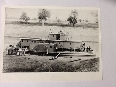
Black and white photograph, Earliest 1897
P. S. Marion Dimensions: 107 ft 11 in X 5 ft 3 in Tonnage: 157 tons Built: 1897, at Milang, S. A. References: Book: "Murray River Paddlesteamers" by D. Wardle. pp.22 Riverboats and Rivermen by W. Drake & M. PagePaddlesteamers were a common form of transport along the Murray river in the early 20th century. This photo shows a number of travellers on the boat, judging by their attire, workmen, cook, men in suits and ties as well as a group of people sitting on the bank, possible a woman and children with dog waiting for the boat to depart. There is also a horse drawn wagon with a number of people on and around it that could be waiting to pick up goods (or have unloaded) from the boat. At the back of the boat stacks of wheat bags (?) are visible.Black and white photograph of P. S. Marion moored by a river bank. There is a group of men standing towards the bow and a horse drawn carriage on the bank near the stern. Copy of an original photograph.On the front: MARION on the bow of the boat and on the wheelhouse. On reverse, in pen: Marion. where? Stamped in black: National Library of Australia.riverboats,, paddle steamers, p. s. marion -
 Port of Echuca
Colour photograph, 1977
... on goods transported from N. S. W. to Victoria. The taxes were ...Customs building: built 1884 to handle goods entering Victoria up to 1901. Building classified B by National Trust.Customs houses, of similar design, were built along the Murray river to collect taxes on goods transported from N. S. W. to Victoria. The taxes were collected up until Federation in 1901. The Victorian railways used it as an office until about the 1960 when it became a private dwelling. The Customs House at Echuca is now owned by The Port of Echuca and has been used to house a wine tasting businesses, cafe and local produce retail and art gallery.Colour photograph of Customs House at Echuca port.In ink on reverse: Dec.77-M: Print made by Kodak: Kodak. In pencil Customs Housecustoms house, echuca, echuca historical buildings, echuca, port of (customs history) -
 Eltham District Historical Society Inc
Photograph - Aerial Photograph, Landata, Eltham / Research, Vic, Jan. 1951
Centred on Brinkkotter Road opposite Yarramie Reserve, Eltham bounded by Maroondah Aqueduct to north, Nyora Road to south, Eltham College to east and Leane Drive to west. Historic Aerial Imagery Source: Landata.vic.gov.au Aerial Photo Details: Project No :65 Project : MELBOURNE AND METROPOLITAN PROJECT NO. 2 Run : 7 Frame : 8 Date : 01/1951 Film Type : B/W Camera : EAG9 Flying Height : 12200 Scale : 12000 Film Number : 1419 GDA2020 : 37°42'32"S, 145°10'41"E MGA2020 : 339408, 5824924 (55) Melways : 22 F3 (ed. 42)Historical aerial photos and photo maps provide viusal evidence of the chronology of changes to the built landscape of the district and assist in dating other imagesaerial photo, 1951-01, eltham, neil webster collection, brinkkotter road, eltham college, leane drive, maroondah aqueduct, melways 22f3, nyora road, yarramie reserve -
 Eltham District Historical Society Inc
Photograph - Aerial Photograph, Landata, Eltham, Vic, Jan. 1951
Centred on Beard Street between Main Road and Frank Street, Eltham bounded by Maroondah Aqueduct to north, Arthur Street to south, Maroong Drive to east and Catholic Ladies College to west. Historic Aerial Imagery Source: Landata.vic.gov.au Aerial Photo Details: Project No :65 Project : MELBOURNE AND METROPOLITAN PROJECT NO. 2 Run : 7 Frame : 9 Date : 01/1951 Film Type : B/W Camera : EAG9 Flying Height : 12200 Scale : 12000 Film Number : 1419 GDA2020 : 37°42'23"S, 145°09'39"E MGA2020 : 337874, 5825170 (55) Melways : 22 B3 (ed. 42)Historical aerial photos and photo maps provide viusal evidence of the chronology of changes to the built landscape of the district and assist in dating other imagesaerial photo, 1951-01, eltham, neil webster collection, arthur street, beard street, catholic ladies college, frank street, main road, maroondah aqueduct, maroong drive, melway 22b3, research (vic.) -
 Eltham District Historical Society Inc
Photograph - Aerial Photograph, Landata, Eltham, Vic, Jan. 1951
Centred on Allison Crecent Reserve, Sherbrook Road and Scenic Crescent, Eltham bounded by Allendale Road to north, Dudley Street to south, Zig Zag Road to east and St Helena Road to west. Historic Aerial Imagery Source: Landata.vic.gov.au Aerial Photo Details: Project No :65 Project : MELBOURNE AND METROPOLITAN PROJECT NO. 2 Run : 7 Frame : 10 Date : 01/1951 Film Type : B/W Camera : EAG9 Flying Height : 12200 Scale : 12000 Film Number : 1419 GDA2020 : 37°42'14"S, 145°08'36"E MGA2020 : 336339, 5825416 (55) Melways : 21 H2 (ed. 42)Historical aerial photos and photo maps provide viusal evidence of the chronology of changes to the built landscape of the district and assist in dating other imagesaerial photo, 1951-01, eltham, neil webster collection, allendale road, allison crecent reserve, dudley street, melway 21h2, scenic crescent, sherbrook road, st helena road, zig zag road -
 Eltham District Historical Society Inc
Photograph - Aerial Photograph, Landata, Eltham North, Feb. 1956
Centred on present day 54 Kelway Crescent, Eltham North bounded by Glen Gully Road to north, Meruka Drive to south, Eltham College to east and Leach Street to west. Historic Aerial Imagery Source: Landata.vic.gov.au Aerial Photo Details: Project No :250 Project : MELBOURNE OUTER SUBURBS PROJECT Run : 17 Frame : 113 Date : 02/1956 Film Type : B/W Camera : EAG9 Flying Height : 10000 Scale : 12000 Film Number : 1176 GDA2020 : 37°42'16"S, 145°08'08"E MGA2020 : 335650, 5825336 (55) Melways : 21 G2 (ed. 42)aerial photo, 1956-02, eltham, eltham north, glen gully road, leach street, main road, melway 21g2, meruka drive, montmorency, neil webster collection -
 Eltham District Historical Society Inc
Photograph - Aerial Photograph, Landata, Montmorency, Feb. 1956
Centred on present day Tahlee Place Reserve and Sherbourne Preschool, Montmorency bounded by Progress Road to north, Withers Way to south, Main Road to east and Leach Street to west. Historic Aerial Imagery Source: Landata.vic.gov.au Aerial Photo Details: Project No :250 Project : MELBOURNE OUTER SUBURBS PROJECT Run : 17 Frame : 114 Date : 02/1956 Film Type : B/W Camera : EAG9 Flying Height : 10000 Scale : 12000 Film Number : 1176 GDA2020 : 37°42'50"S, 145°08'02"E MGA2020 : 335512, 5824286 (55) Melways : 21 F5 (ed. 42)aerial photo, 1956-02, neil webster collection, central park, eltham, leach street, main road, melway 21f5, montmorency, progress road, withers way, sherbourne preschool, tahlee place reserve -
 Eltham District Historical Society Inc
Photograph - Aerial Photograph, Landata, Montmorency, Feb. 1956
Centred on present day Grand Boulevard and Olympic Way, Montmorency bounded by Diamond Street to north, Old Eltham Road and Eltham Lower Park to south, Bible Street to east and Para Road to west. Historic Aerial Imagery Source: Landata.vic.gov.au Aerial Photo Details: Project No :250 Project : MELBOURNE OUTER SUBURBS PROJECT Run : 17 Frame : 115 Date : 02/1956 Film Type : B/W Camera : EAG9 Flying Height : 10000 Scale : 12000 Film Number : 1176 GDA2020 : 37°43'24"S, 145°07'55"E MGA2020 : 335375, 5823236 (55) Melways : 21 F7 (ed. 42)aerial photo, 1956-02, neil webster collection, eltham, main road, montmorency, bible street, diamond street, eltham lower park, grand boulevard, melway 21f7, old eltham road, olympic way, para road -
 Eltham District Historical Society Inc
Photograph - Aerial Photograph, Landata, Lower Plenty, Feb. 1956
Centred on present day 217 Old Eltham Road, Lower Plenty bounded by Pitt Street to north, Yarra River to south, Main Road to east and Bonds Road to west. Historic Aerial Imagery Source: Landata.vic.gov.au Aerial Photo Details: Project No :250 Project : MELBOURNE OUTER SUBURBS PROJECT Run : 17 Frame : 116 Date : 02/1956 Film Type : B/W Camera : EAG9 Flying Height : 10000 Scale : 12000 Film Number : 1176 GDA2020 : 37°43'58"S, 145°07'49"E MGA2020 : 335237, 5822186 (55) Melways : 21 E10 (ed. 42)aerial photo, 1956-02, neil webster collection, eltham, main road, bonds road, elham, lower plenty, melway 21e10, pitt street, yarra river -
 Eltham District Historical Society Inc
Photograph - Aerial Photograph, Landata, Eltham, Feb. 1956
Centred on present day Culla Hill and Petty's Orchard, Eltham bounded by Brougham Street and Mount Pleasant Road to north, Monckton Road, Templestowe to south, Reynolds Road to east and Eltham Lower Park and Hohnes Road to west. Historic Aerial Imagery Source: Landata.vic.gov.au Aerial Photo Details: Project No :250 Project : MELBOURNE OUTER SUBURBS PROJECT Run : 18 Frame : 92 Date : 02/1956 Film Type : B/W Camera : EAG9 Flying Height : 10000 Scale : 12000 Film Number : 1176 GDA2020 : 37°43'35"S, 145°09'31"E MGA2020 : 337735, 5822959 (55) Melways : 22 B8 (ed. 42)aerial photo, 1956-02, neil webster collection, eltham, brougham steet, culla hill, eltham lower park, hohnes road, melway 22b8, monckton road, mount pleasant road, petty's orchard, reynolds road, sweeneys lane, templestowe, yarra river -
 Eltham District Historical Society Inc
Photograph - Aerial Photograph, Landata, Eltham, Feb. 1956
Centred on present day Mount Plaeasant Road near Dalton Street, Eltham bounded by Luck Street to north, Eltham Lower Park to south, Reynolds Road to east and Central Park to west Historic Aerial Imagery Source: Landata.vic.gov.au Aerial Photo Details: Project No :250 Project : MELBOURNE OUTER SUBURBS PROJECT Run : 18 Frame : 93 Date : 02/1956 Film Type : B/W Camera : EAG9 Flying Height : 10000 Scale : 12000 Film Number : 1176 GDA2020 : 37°43'02"S, 145°09'38"E MGA2020 : 337871, 5823961 (55) Melways : 22 B6 (ed. 42)aerial photo, 1956-02, neil webster collection, eltham, central park, eltham lower park, luck street, melway 22b6, nyora road, reynolds road, dalton street, mount pleasant road -
 Eltham District Historical Society Inc
Photograph - Aerial Photograph, Landata, Eltham, Feb. 1956
Centred on present day Shalbury Avenue, Eltham bounded by Leane Drive and Parsons Road to north, Nyora Road to south, Reynolds Road to east and the Diamond Creek to west Historic Aerial Imagery Source: Landata.vic.gov.au Aerial Photo Details: Project No :250 Project : MELBOURNE OUTER SUBURBS PROJECT Run : 18 Frame : 95 Date : 02/1956 Film Type : B/W Camera : EAG9 Flying Height : 10000 Scale : 12000 Film Number : 1176 GDA2020 : 37°41'57"S, 145°09'51"E MGA2020 : 338145, 5825965 (55) Melways : 22 C1 (ed. 42)aerial photo, 1956-02, neil webster collection, eltham, diamond creek (creek), melway 22c1, nyora road, parsons road, reynolds road, shalbury avenue -
 Eltham District Historical Society Inc
Photograph - Aerial Photograph, Landata, Eltham, Vic, Feb. 1956
Centred on present day Parsons Avenue at Leane Drive near the Maroondah Aqueduct, Eltham bounded by Lorimer Road to north, Thompson Crescent and Norman Road to south, Bells Hill Road to east and Parsons Road to west Historic Aerial Imagery Source: Landata.vic.gov.au Aerial Photo Details: Project No :250 Project : MELBOURNE OUTER SUBURBS PROJECT Run : 19 Frame : 5 Date : 02/1956 Film Type : B/W Camera : EAG9 Flying Height : 10000 Scale : 12000 Film Number : 1176 GDA2020 : 37°42'04"S, 145°11'09"E MGA2020 : 340064, 5825786 (55) Melways : 22 H1 (ed. 42)aerial photo, 1956-02, neil webster collection, allendale road, bells hill road, eltham, leane drive, lorimer road, maroondah aqueduct, melway 22h1, norman road, parsons road, research (vic.), thompson crescent -
 Eltham District Historical Society Inc
Photograph - Aerial Photograph, Landata, Research, Vic, Feb. 1956
Centred on present day Thompson Crescent, Research bounded by Maroondah Aqueduct to north, Thompson Crescent and Nyora Road to south, Bells Hill Road to east and Eucalyptus Road to west Historic Aerial Imagery Source: Landata.vic.gov.au Aerial Photo Details: Project No :250 Project : MELBOURNE OUTER SUBURBS PROJECT Run : 19 Frame : 6 Date : 02/1956 Film Type : B/W Camera : EAG9 Flying Height : 10000 Scale : 12000 Film Number : 1176 GDA2020 : 37°42'38"S, 145°11'02"E MGA2020 : 339927, 5824736 (55) Melways : 22 H4 (ed. 42)aerial photo, 1956-02, neil webster collection, bells hill road, eltham, eucalyptus road, maroondah aqueduct, melway 22h4, nyora road, research (vic.), thompson crescent -
 Eltham District Historical Society Inc
Photograph - Aerial Photograph, Landata, Eltham, Vic, Apr. 1963
Centred on present day Zig Zag Road and Main Road, Eltham bounded by Maroondah Aqueduct to north, Thompson Crescent and Arthur Street to south, Parsons Road to east and Glen Park Road and Banks Road to west. Historic Aerial Imagery Source: Landata.vic.gov.au Aerial Photo Details: Project No :486 Project : MELBOURNE (1963) PROJECT Run : 5 Frame : 59 Date : 04/1963 Film Type : B/W Camera : RC8 Flying Height : 5100 Scale : 9600 Film Number : 1805 GDA2020 : 37°42'24"S, 145°08'52"E MGA2020 : 336716, 5825114 (55) Melways : 21 J3 (ed. 42)aerial photo, neil webster collection, eltham, 1963-04, arthur street, banks road, glen park road, maroondah aqueduct, melway 21j3, parsons road -
 Eltham District Historical Society Inc
Photograph - Aerial Photograph, Landata, Eltham, Vic, Apr. 1963
Centred on present day Floriston Grove, Eltham bounded by Maroondah Aqueduct to north, Thompson Crescent and Diosma Road to south, Research Shops to east and Glen Park Road and Park West Road to west. Historic Aerial Imagery Source: Landata.vic.gov.au Aerial Photo Details: Project No :486 Project : MELBOURNE (1963) PROJECT Run : 5 Frame : 60 Date : 04/1963 Film Type : B/W Camera : RC8 Flying Height : 5100 Scale : 9600 Film Number : 1805 GDA2020 : 37°42'24"S, 145°09'29"E MGA2020 : 337622, 5825128 (55) Melways : 22 B3 (ed. 42)aerial photo, neil webster collection, eltham, 1963-04, diosma road, floriston grove, maroondah aqueduct, melway 22b3, park west road, research (vic.), research shops -
 Eltham District Historical Society Inc
Photograph - Aerial Photograph, Landata, Research, Vic, Apr. 1963
Centred on present day Thompson Crescent and Nicholson Close, Research bounded by Maroondah Aqueduct to north, Nyora Road to south, Eltham College to east and Eltham Gateway Hotel to west. Historic Aerial Imagery Source: Landata.vic.gov.au Aerial Photo Details: Project No :486 Project : MELBOURNE (1963) PROJECT Run : 5 Frame : 61 Date : 04/1963 Film Type : B/W Camera : RC8 Flying Height : 5100 Scale : 9600 Film Number : 1805 GDA2020 : 37°42'24"S, 145°10'06"E MGA2020 : 338528, 5825143 (55) Melways : 22 D3 (ed. 42)aerial photo, neil webster collection, eltham, 1963-04, eltham college, eltham gateway hotel and conference centre, maroondah aqueduct, melway 22d3, nicholson close, nyora road, research (vic.), thompson crescent -
 Eltham District Historical Society Inc
Photograph - Aerial Photograph, Landata, Research, Vic, Apr. 1963
Centred on present day Marconi Court, Research bounded by Maroondah Aqueduct to north, Thompson Crescent to south, Joselyn Drive to east and Eltham Research Oval to west. Historic Aerial Imagery Source: Landata.vic.gov.au Aerial Photo Details: Project No :486 Project : MELBOURNE (1963) PROJECT Run : 5 Frame : 62 Date : 04/1963 Film Type : B/W Camera : RC8 Flying Height : 5100 Scale : 9600 Film Number : 1805 GDA2020 : 37°42'24"S, 145°10'43"E MGA2020 : 339434, 5825157 (55) Melways : 22 F3 (ed. 42)aerial photo, neil webster collection, 1963-04, joselyn drive, marconi court, melway 22f3, research (vic.), research oval, thompson crescent