Showing 9541 items matching "street names"
-
 City of Moorabbin Historical Society (Operating the Box Cottage Museum)
Newsletter - CMHS April 2014 pdf, April 2014
... involving significant Street names in the area eg Monash, Chauvel... for WW1 Centenary involving significant Street names in the area ...The City of Moorabbin Historical Society was formed c 1960 by a group of Moorabbin area residents who were concerned that the history of the area should be preserved. A good response to a call for items related to the historical area of Moorabbin Shire brought donations of a wide variety of artefacts that are now preserved by the current members of CMHS at Box Cottage Museum. Helen Stanley, Secretary of CMHS, began producing a Newsletter for members in April 2007 to provide current information and well researched items of historical interest. Jim Dale continued to produce the Newsletter in 2013 after Helen resigned. 3 x A4 paper pages printed on one side with colour photographs, Jim Dale, President, welcomes members to the April 27th Meeting at Box Cottage. There were many visitors on the February Open Day including Jeff Marriot. In March some guests from a Wedding at the Rotunda in Joyce Park visited. Chris and Judy Hawker, relatives of early aviator Harry Hawker were presented to Her Excellency, the Governor General of Australia, Quentin Bryce during the Centenary of Military Aviation Air Show, held at Point Cook on March1st & 2nd. Jim representing CMHS attended this memorable occasion. Jim also attended Moorabbin Primary School March 3rd where he told the pupils about Harry Hawker. March 22nd Jim, Valma and Anne attended the Moorabbin Primary School Fete handing out leaflets and talking about Box Cottage Museum. City of Glen Eira is conducting a project for WW1 Centenary involving significant Street names in the area eg Monash, Chauvel, Birdwood etc. Jim has compiled a story about Thomas Calcutt 1809 - 45, a shepherd who emigrated from Oxford, England to Brighton Victoria 1842. He was part of the Henry Dendy 's assignment of settlers. Thomas obtained employment with Public Works and lived in Brighton with his family. Sadly he died during the 6km walk home from his work in St Kilda to Brighton 1845. After a 2 day search his body was found. He was the first immigrant to die in this area and subject to an Inquest.City of Moorabbin Historical Society Newsletter APRIL 2014city of moorabbin historical society, stanley helen, dale jim, melbourne, moorabbin, brighton, cheltenham, ormond, bentleigh, market gardeners, pioneers, early settlers, east bentleigh, city of kingston, marriott jeff, hawker harry, aviators, moorabbin primary school, peulich paul, point cook airforce base, bryce dame quentin, hawker judy, hawker christopher, city of glen eira, world war 1 1914-18, monash sir john, calcutt thomas, calcutt eleanor, calcutt george, calcutt rosanna, calcutt henry, dendy henry, henry dendy's special survey 1841, wilmot w b md jp, st andrew's church of england brighton victoria -
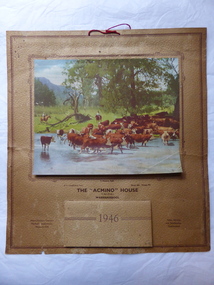 Warrnambool and District Historical Society Inc.
Calendar
... was situated at the corner of Lava and Kepler Streets in Warrnambool... at the corner of Lava and Kepler Streets in Warrnambool. The name ...This calendar has been distributed as a advertising item for Earl’s agricultural machinery and oil depot. The business was situated at the corner of Lava and Kepler Streets in Warrnambool. The name, Acmino’ stood for Allis-Chalmers, Mitchell’s Implements, Neptune Oils’. Distributing calendars at Christmas time for the following year was, and still is, a popular advertising tool for businesses. This calendar is of minor interest as an example of the use made by businesses in the 1940s of calendars as advertising tools. It also has a local Warrnambool connection, the agricultural machinery business of F. Earl. This is a 1946 calendar with a buff-coloured sheet of crinkled paper with a brown border. It has a coloured photograph of two men droving cattle near a river and it ispasted on to the paper with a brown border around the photograph. The calendar for 1946 is printed on to the paper and also in monthly sheets pasted on to the paper on top of each other. The printing on the calendar is brown. On the back of the calendar is written in black ink, ‘French Bros’. The calendar has a red piece of string at the top for hanging the calendar up on a wall or cupboard. The calendar is torn at the edges and somewhat stained.‘With Compliments from the “Acmino” House, F.Earl (Prop.)Warrnambool Phone 484 Private 75’ ‘Allis-Chalmers Tractors Mitchell’s Implements Neptune Oils’ ‘Sales, Service and Satisfaction Guaranteed’ ‘French Bros’ ‘acmino’ house, warrnambool, f. earl, history of warrnambool -
 Warrnambool and District Historical Society Inc.
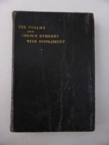
Book, The Psalms & Church Hymnary, c.1920
... street and the name ‘Swinton’ is well-known in Warrnambool. Agnes... a commercial business in the same street and the name ‘Swinton’ is well ...This book belonged to Agnes Swinton (b.1900). She was the daughter of John and Charlotte Swinton of Warrnambool. Her father, John, was the fifth son of William and Ann Swinton who came to Warrnambool in 1854 and established a store in Timor Street. The Swinton family still operates a commercial business in the same street and the name ‘Swinton’ is well-known in Warrnambool. Agnes’ sister, Doris had a distinguished military career in World War Two and was a long-term Matron of the Warrnambool Hospital. This book is of considerable interest as it belonged to a member of the Swinton family which has been connected with Warrnambool’s history since the 1850s. This is a leather-covered book of 216 pages, plus a Supplement of 12 pages. The text is printed in two columns to a page. The front cover has gold lettering printed into the leather. The cover is a little crumpled and some of the pages are dog-eared. ‘August 1922’ ‘Agnes S. Swinton, ‘The Brae’, 4 Merri Crescent, Warrnambool’ swinton family, warrnambool, history of warrnambool, presbyterian church, warrnambool -
 The Beechworth Burke Museum
Photograph, c1960
... resident of Beechworth, who is remembered in a street name adjacent... resident of Beechworth, who is remembered in a street name adjacent ...The photograph depicts a view across the water at Lake Sambell. The image dates from approximately 1960. The present day park and reserve occupies the site of the former Rocky Mountain Mining Company, an open-cut sluice mine that began operations in the mid-Nineteenth Century and operated until the early 1900s, through the peak of Victoria’s Gold Rush. It was converted into a park and leisure area in the 1920s. Lake Sambell was formally opened to the public on Friday 5th October 1928 and was opened by the Victorian Government’s Minister of Lands, Mr Bailey, as part of initiatives to boost the economies and development of country towns. The lake was named after Mr L.H. Sambell, a shire engineer and secretary of the Forward Beechworth Committee who was involved in promoting the transformation of the mining site and promoting plantation forestry and tourism as alternative industries. £300 to begin the process was provided by Mr J. McConvill, a former resident of Beechworth, who is remembered in a street name adjacent to the lake. Residents of Beechworth have worked to raise funds to improve the Lake Sambell reserve several times, such as efforts in the 1930s and 1940s to raise the banks several feet to deepen the water for swimming purposes. Fundraising campaigns include the ‘Ugly Man’ competition conducted on behalf of the Wallace Park-Lake Sambell Development Scheme. The latter competition was run by the Fire Brigade Bend’s team as part of a larger competition called the ‘Mile of Pennies’; it was won by Mr Len Knight of Beechworth’s Commercial Hotel. The ‘Mile of Pennies’ was conducted at a Carnival held on New Year’s Eve, 1947. It was proposed by the Beechworth and District Progress Association. As well as improving swimming facilities, funds were raised to install a caravan park facility near the lake. Funds were also donated by commercial entities, such as £250 received from Zwar Bros. Pty Ltd. The photograph is significant as it shows the level of development of Beechworth in the early to mid-Twentieth Century. Sepia rectangular photograph printed on matte photographic paperObverse: nil. Reverse: 3470 / Velox (paper mark)beechworth, beechworth lake, lake sambell, lake, beechworth and district progress association, forward beechworth committee, ugly man, mile of pennies, wallace park lake sambell development scheme, wallace park-lake sambell development scheme, zwar bros, zwar, l.h. sambell, j. mcconvill, minister of lands, commercial hotel, len knight, rocky mountain mining company, rocky mountain mining co, gold rush, redevelopment, transformation, community fundraising -
 The Beechworth Burke Museum
Photograph, c1960
... resident of Beechworth, who is remembered in a street name adjacent... resident of Beechworth, who is remembered in a street name adjacent ...The photographs in this set depict views across the water at Lake Sambell. The images date from approximately 1960. The present day park and reserve occupies the site of the former Rocky Mountain Mining Company, an open-cut sluice mine that began operations in the mid-19th Century and operated until the early 1900s, through the peak of Victoria’s Gold Rush. It was converted into a park and leisure area in the 1920s. Lake Sambell was formally opened to the public on Friday 5th October 1928 and was opened by the Victorian Government’s Minister of Lands, Mr Bailey, as part of initiatives to boost the economies and development of country towns. The lake was named after Mr L.H. Sambell, a shire engineer and secretary of the Forward Beechworth Committee who was involved in promoting the transformation of the mining site and promoting plantation forestry and tourism as alternative industries. £300 to begin the process was provided by Mr J. McConvill, a former resident of Beechworth, who is remembered in a street name adjacent to the lake. Residents of Beechworth have worked to raise funds to improve the Lake Sambell reserve several times, such as efforts in the 1930s and 1940s to raise the banks several feet to deepen the water for swimming purposes. Fundraising campaigns include the ‘Ugly Man’ competition conducted on behalf of the Wallace Park-Lake Sambell Development Scheme. The latter competition was run by the Fire Brigade Bend’s team as part of a larger competition called the ‘Mile of Pennies’; it was won by Mr Len Knight of Beechworth’s Commercial Hotel. The ‘Mile of Pennies’ was conducted at a Carnival held on New Year’s Eve, 1947. It was proposed by the Beechworth and District Progress Association. As well as improving swimming facilities, funds were raised to install a caravan park facility near the lake. Funds were also donated by commercial entities, such as £250 received from Zwar Bros. Pty Ltd.The photographs are significant as they show the level of development in Beechworth in the middle of the Twentieth Century. Four sepia and black and white rectangular photographs printed on matte photographic paper. 3469.1: Obverse: nil Reverse: 3469-1 3469.2: Obverse: nil Reverse: 3469-2 3469.3: Obverse: nil Reverse: 3469-3 3469.4: Obverse: nil Reverse: 3469-4beechworth, beechworth lake, lake sambell, lake, beechworth and district progress association, forward beechworth committee, ugly man, mile of pennies, wallace park lake sambell development scheme, wallace park-lake sambell development scheme, zwar bros, zwar, l.h. sambell, j. mcconvill, minister of lands, commercial hotel, len knight, rocky mountain mining company, rocky mountain mining co, gold rush, redevelopment, transformation, community fundraising -
 Flagstaff Hill Maritime Museum and Village
Book - Medical Textbook, Young J. Pentland, Manual of Practical Anatomy, Vol. 2, Thorax, Head and Neck, 1894
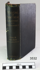
... , Edinburgh and London. Label "W.R. Angus/309 Koroit Street...Label "W.R. Angus/309 Koroit Street/Warrnambool/ Victoria.... Angus/309 Koroit Street/Warrnambool/ Victoria, 3280". Name ...This textbook was used by Doctor Angus during his medical studies at Adelaide University. It was donated to Flagstaff Hill Maritime Village by the family of Doctor William Roy Angus, Surgeon and Oculist. It is part of the “W.R. Angus Collection” that includes historical medical equipment, surgical instruments and material once belonging to Dr Edward Ryan and Dr Thomas Francis Ryan, (both of Nhill, Victoria) as well as Dr Angus’ own belongings. The Collection’s history spans the medical practices of the two Doctors Ryan, from 1885-1926 plus that of Dr Angus, up until 1969. ABOUT THE “W.R.ANGUS COLLECTION” Doctor William Roy Angus M.B., B.S., Adel., 1923, F.R.C.S. Edin.,1928 (also known as Dr Roy Angus) was born in Murrumbeena, Victoria in 1901 and lived until 1970. He qualified as a doctor in 1923 at University of Adelaide, was Resident Medical Officer at the Royal Adelaide Hospital in 1924 and for a period was house surgeon to Sir (then Mr.) Henry Simpson Newland. Dr Angus was briefly an Assistant to Dr Riddell of Kapunda, then commenced private practice at Curramulka, Yorke Peninsula, SA, where he was physician, surgeon and chemist. In 1926, he was appointed as new Medical Assistant to Dr Thomas Francis Ryan (T.F. Ryan, or Tom), in Nhill, Victoria, where his experiences included radiology and pharmacy. In 1927 he was Acting House Surgeon in Dr Tom Ryan’s absence. Dr Angus had become engaged to Gladys Forsyth and they decided he would take time to further his studies overseas in the UK in 1927. He studied at London University College Hospital and at Edinburgh Royal Infirmary and in 1928, was awarded FRCS (Fellow from the Royal College of Surgeons), Edinburgh. He worked his passage back to Australia as a Ship’s Surgeon on the on the Australian Commonwealth Line’s SS Largs Bay. Dr Angus married Gladys in 1929, in Ballarat. (They went on to have one son (Graham 1932, born in SA) and two daughters (Helen (died 12/07/1996) and Berenice (Berry), both born at Mira, Nhill ) Dr Angus was a ‘flying doctor’ for the A.I.M. (Australian Inland Ministry) Aerial Medical Service in 1928 . The organisation began in South Australia through the Presbyterian Church in that year, with its first station being in the remote town of Oodnadatta, where Dr Angus was stationed. He was locum tenens there on North-South Railway at 21 Mile Camp. He took up this ‘flying doctor’ position in response to a call from Dr John Flynn; the organisation was later known as the Flying Doctor Service, then the Royal Flying Doctor Service. A lot of his work during this time involved dental surgery also. Between 1928-1932 he was surgeon at the Curramulka Hospital, Yorke Peninsula, South Australia. In 1933 Dr Angus returned to Nhill where he’d previously worked as Medical Assistant and purchased a share of the Nelson Street practice and Mira hospital from Dr Les Middleton one of the Middleton Brothers, the current owners of what was once Dr Tom Ryan’s practice. Dr L Middleton was House Surgeon to the Nhill Hospital 1926-1933, when he resigned. [Dr Tom Ryan’s practice had originally belonged to his older brother Dr Edward Ryan, who came to Nhill in 1885. Dr Edward saw patients at his rooms, firstly in Victoria Street and in 1886 in Nelson Street, until 1901. The Nelson Street practice also had a 2 bed ward, called Mira Private Hospital ). Dr Edward Ryan was House Surgeon at the Nhill Hospital 1884-1902 . He also had occasions where he successfully performed veterinary surgery for the local farmers too. Dr Tom Ryan then purchased the practice from his brother in 1901. Both Dr Edward and Dr Tom Ryan work as surgeons included eye surgery. Dr Tom Ryan performed many of his operations in the Mira private hospital on his premises. He too was House Surgeon at the Nhill Hospital 1902-1926. Dr Tom Ryan had one of the only two pieces of radiology equipment in Victoria during his practicing years – The Royal Melbourne Hospital had the other one. Over the years Dr Tom Ryan gradually set up what was effectively a training school for country general-practitioner-surgeons. Each patient was carefully examined, including using the X-ray machine, and any surgery was discussed and planned with Dr Ryan’s assistants several days in advance. Dr Angus gained experience in using the X-ray machine there during his time as assistant to Dr Ryan. Dr Tom Ryan moved from Nhill in 1926. He became a Fellow of the Royal Australasian College of Surgeons in 1927, soon after its formation, a rare accolade for a doctor outside any of the major cities. He remained a bachelor and died suddenly on 7th Dec 1955, aged 91, at his home in Ararat. Scholarships and prizes are still awarded to medical students in the honour of Dr T.F. Ryan and his father, Dr Michael Ryan, and brother, John Patrick Ryan. ] When Dr Angus bought into the Nelson Street premises in Nhill he was also appointed as the Nhill Hospital’s Honorary House Surgeon 1933-1938. His practitioner’s plate from his Nhill surgery states “HOURS Daily, except Tuesdays, Fridays and Saturday afternoons, 9-10am, 2-4pm, 7-8pm. Sundays by appointment”. This plate is now mounted on the doorway to the Port Medical Office at Flagstaff Hill Maritime Village, Warrnambool. Dr Edward Ryan and Dr Tom Ryan had an extensive collection of historical medical equipment and materials spanning 1884-1926 and when Dr Angus took up practice in their old premises he obtained this collection, a large part of which is now on display at the Port Medical Office at Flagstaff Hill Maritime Village in Warrnambool. During his time in Nhill Dr Angus was involved in the merging of the Mira Hospital and Nhill Public Hospital into one public hospital and the property titles passed on to Nhill Hospital in 1939. In 1939 Dr Angus and his family moved to Warrnambool where he purchased “Birchwood,” the 1852 home and medical practice of Dr John Hunter Henderson, at 214 Koroit Street. (This property was sold in1965 to the State Government and is now the site of the Warrnambool Police Station. ). The Angus family was able to afford gardeners, cooks and maids; their home was a popular place for visiting dignitaries to stay whilst visiting Warrnambool. Dr Angus had his own silk worm farm at home in a Mulberry tree. His young daughter used his centrifuge for spinning the silk. Dr Angus was appointed on a part-time basis as Port Medical Officer (Health Officer) in Warrnambool and held this position until the 1940’s when the government no longer required the service of a Port Medical Officer in Warrnambool; he was thus Warrnambool’s last serving Port Medical Officer. (The duties of a Port Medical Officer were outlined by the Colonial Secretary on 21st June, 1839 under the terms of the Quarantine Act. Masters of immigrant ships arriving in port reported incidents of diseases, illness and death and the Port Medical Officer made a decision on whether the ship required Quarantine and for how long, in this way preventing contagious illness from spreading from new immigrants to the residents already in the colony.) Dr Angus was a member of the Australian Medical Association, for 35 years and surgeon at the Warrnambool Base Hospital 1939-1942, He served as a Surgeon Captain during WWII1942-45, in Ballarat, Victoria, and in Bonegilla, N.S.W., completing his service just before the end of the war due to suffering from a heart attack. During his convalescence he carved an intricate and ‘most artistic’ chess set from the material that dentures were made from. He then studied ophthalmology at the Royal Melbourne Eye and Ear Hospital and created cosmetically superior artificial eyes by pioneering using the intrascleral cartilage. Angus received accolades from the Ophthalmological Society of Australasia for this work. He returned to Warrnambool to commence practice as an ophthalmologist, pioneering in artificial eye improvements. He was Honorary Consultant Ophthalmologist to Warrnambool Base Hospital for 31 years. He made monthly visits to Portland as a visiting surgeon, to perform eye surgery. He represented the Victorian South-West subdivision of the Australian Medical Association as its secretary between 1949 and 1956 and as chairman from 1956 to 1958. In 1968 Dr Angus was elected member of Spain’s Barraquer Institute of Barcelona after his research work in Intrasclearal cartilage grafting, becoming one of the few Australian ophthalmologists to receive this honour, and in the following year presented his final paper on Living Intrasclearal Cartilage Implants at the Inaugural Meeting of the Australian College of Ophthalmologists in Melbourne In his personal life Dr Angus was a Presbyterian and treated Sunday as a Sabbath, a day of rest. He would visit 3 or 4 country patients on a Sunday, taking his children along ‘for the ride’ and to visit with him. Sunday evenings he would play the pianola and sing Scottish songs to his family. One of Dr Angus’ patients was Margaret MacKenzie, author of a book on local shipwrecks that she’d seen as an eye witness from the late 1880’s in Peterborough, Victoria. In the early 1950’s Dr Angus, painted a picture of a shipwreck for the cover jacket of Margaret’s book, Shipwrecks and More Shipwrecks. She was blind in later life and her daughter wrote the actual book for her. Dr Angus and his wife Gladys were very involved in Warrnambool’s society with a strong interest in civic affairs. Their interests included organisations such as Red Cross, Rostrum, Warrnambool and District Historical Society (founding members), Wine and Food Society, Steering Committee for Tertiary Education in Warrnambool, Local National Trust, Good Neighbour Council, Housing Commission Advisory Board, United Services Institute, Legion of Ex-Servicemen, Olympic Pool Committee, Food for Britain Organisation, Warrnambool Hospital, Anti-Cancer Council, Boys’ Club, Charitable Council, National Fitness Council and Air Raid Precautions Group. He was also a member of the Steam Preservation Society and derived much pleasure from a steam traction engine on his farm. He had an interest in people and the community He and his wife Gladys were both involved in the creation of Flagstaff Hill, including the layout of the gardens. After his death (28th March 1970) his family requested his practitioner’s plate, medical instruments and some personal belongings be displayed in the Port Medical Office surgery at Flagstaff Hill Maritime Village, and be called the “W. R. Angus Collection”. The W.R. Angus Collection is significant for still being located at the site it is connected with, Doctor Angus being the last Port Medical Officer in Warrnambool. The collection of medical instruments and other equipment is culturally significant, being an historical example of medicine from late 19th to mid-20th century. Dr Angus assisted Dr Tom Ryan, a pioneer in the use of X-rays and in ocular surgery. Manual of Practical Anatomy, Vol. 2, Thorax, Head and Neck. D.J. Cunningham. Label Pub. 1894, Young J. Pentland, Edinburgh and London. Label "W.R. Angus/309 Koroit Street/Warrnambool/ Victoria, 3280". Name in pencil looks like “A S Cobbledick”. Pencil “W.R. ANGUS/MED SCHOOL/ADELAIDE UNI/1921" (W.R. Angus Collection)Label "W.R. Angus/309 Koroit Street/Warrnambool/ Victoria, 3280". Name in pencil looks like “A S Cobbledick”. Pencil “W.R. ANGUS/MED SCHOOL/ADELAIDE UNI/1921" flagstaff hill, warrnambool, shipwrecked-coast, flagstaff-hill, flagstaff-hill-maritime-museum, maritime-museum, shipwreck-coast, flagstaff-hill-maritime-village, dr w r angus, medical history, medical education, published 1894, young j. pentland, medical textbook -
 The Beechworth Burke Museum
Photograph, c1960
... is remembered in a street name adjacent to the lake. Residents... is remembered in a street name adjacent to the lake. Residents ...The photograph depicts a view across the water at Lake Sambell. The image is thought to date from the 1960s so may show the lake during a period of drought, such as that experienced across South-Eastern Australia in 1967. The present day park and reserve occupies the site of the former Rocky Mountain Mining Company, an open-cut sluice mine that began operations in the mid-Nineteenth Century and operated until the early 1900s, through the peak of Victoria’s Gold Rush. It was converted into a park and leisure area in the 1920s. Lake Sambell was formally opened to the public on Friday 5th October 1928 and was opened by the Victorian Government’s Minister of Lands, Mr Bailey, as part of initiatives to boost the economies and development of country towns. The lake was named after Mr L.H. Sambell, a shire engineer and secretary of the Forward Beechworth Committee who was involved in promoting the transformation of the mining site and promoting plantation forestry and tourism as alternative industries. £300 to begin the process was provided by Mr J. McConvill, a former resident of Beechworth, who is remembered in a street name adjacent to the lake. Residents of Beechworth have worked to raise funds to improve the Lake Sambell reserve several times, such as efforts in the 1930s and 1940s to raise the banks several feet to deepen the water for swimming purposes. Fundraising campaigns include the ‘Ugly Man’ competition conducted on behalf of the Wallace Park-Lake Sambell Development Scheme. The latter competition was run by the Fire Brigade Bend’s team as part of a larger competition called the ‘Mile of Pennies’; it was won by Mr Len Knight of Beechworth’s Commercial Hotel. The ‘Mile of Pennies’ was conducted at a Carnival held on New Year’s Eve, 1947. It was proposed by the Beechworth and District Progress Association. As well as improving swimming facilities, funds were raised to install a caravan park facility near the lake. Funds were also donated by commercial entities, such as £250 received from Zwar Bros. Pty Ltd.The photograph is significant as it shows Lake Sambell at lower water levels, such as may have been experienced during period of drought.Sepia rectangular photograph printed on matte photographic paperObverse: nil Reverse: 3470beechworth, beechworth lake, lake sambell, lake, beechworth and district progress association, forward beechworth committee, ugly man, mile of pennies, wallace park lake sambell development scheme, wallace park-lake sambell development scheme, zwar bros, zwar, l.h. sambell, j. mcconvill, minister of lands, commercial hotel, len knight, rocky mountain mining company, rocky mountain mining co, gold rush, redevelopment, transformation, community fundraising, drought, 1967, 1960s -
 Orbost & District Historical Society
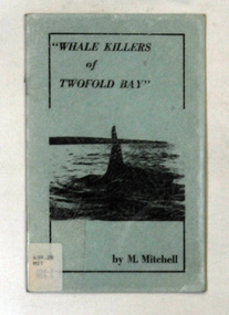
books, Whale Killers of Twofold Bay, circa 1960
... . In Eden there are streets and a park named for both families..... In Eden there are streets and a park named for both families ...Author, Mary Mitchell was the daughter of Charles Wellings early resident of Eden. Charles took many of the early photos of Eden while his brother, Henry, did the research on the Imlay Bros (very early settlers of Orbost) and early Twofold Bay settlers. Mary Wellings married Roy Mitchell of Lower Towamba. In Eden there are streets and a park named for both families.These books record the history of the whaling industry on the south coast of New South Wales.Two copies of a small thin ten page booklet with blue laminated covers. It has black print and a black photo of a whale tail on the front cover.It was written by Mary Mitchell. The book relates the history of whaling at Twofold Bay on the south coast of New South Wales.2116.1 - has a library sticker on the front cove - bottom left hand cornertwofold-bay whaling mitchell-mary welliings -
 Orbost & District Historical Society
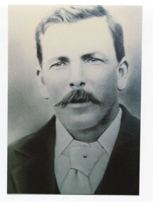
black and white photograph, C1933
... . Duncan Street in Marlo is named for Duncan Cameron..... Duncan Street in Marlo is named for Duncan Cameron. This item ...This is a photograph of Councillor Duncan Cameron who represented East Riding on the Orbost Shire Council from 1911 - 1933. Duncan Cameron was an early settler and licensee of the Marlo Hotel. The Marlo Hotel was the coach stop and the centre for receiving and despatching the mail. The licensee, Duncan Cameron became postmaster when he took over the hotel licence in 1895. Duncan Street in Marlo is named for Duncan Cameron.This item is associated with the Orbost Shire Council. The shire covered an area of 9,347 square kilometres and existed from 1892 until 1994 when it became part of the East Gippsland Shire Council.A black / white head and shoulders portrait photograph of a moustached man in a suit.on back - "Cr Duncan Cameron, East Riding 1911-1933"cameron-duncan marlo-hotel orbost-shire-council -
 National Wool Museum
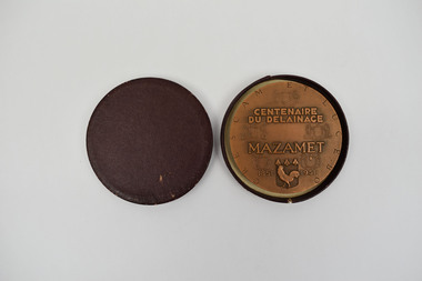
Medallion, CENTENAIRE DU DELAINAGE MAZAMET, 1951
... a strong relation to Australia, with street names such as, Rue de... a strong relation to Australia, with street names such as, Rue de ...This medallion was struck to celebrate the 100th anniversary of fellmongering in Mazamet in 1951. Fellmongering - In French, ‘delainage” means, literally, ‘de-wooling'. It is the industrial process of separating wool from sheepskins. In the 19th century, the southern French town of Mazamet became the world centre of délainage and played an important part in the Australian wool industry. At one time Mazamet was reputed to be the 15th richest town in Europe, and it was said that the town’s branch of the Banque Nationale de Paris (French banking firm) was the second largest in France. At its height, Mazamet had 48 fellmongeries and imported more than 100,000 tonnes of sheepskins a year from the southern hemisphere, mostly from Australia and Argentina. It also supported numerous associated industries such as tanneries, spinning mills and clothing manufacturers. In the 1980s Mazamet’s fellmongering industry fell into decline under pressure from environmental concerns and cheap imports. The town’s last two fellmongeries closed in 2004. The town continues to have a strong relation to Australia, with street names such as, Rue de Australie, Adelaide, Brisbane, Melbourne and Sydney in recognition of a connection to the two distant lands. Today, half a century since wool importation largely ended, there remains a link to the past. Elite quality leather and woollen clothing companies such as Hermes and Chanel still source much of their stock in Mazamet. This medallion was presented to William Haughton and Co. who were one of Australia’s largest wool-buying companies of the first half of the 20th century. Wm Haughton had a major presence in Geelong and its “SKINS WOOL HIDES TALLOW etc.” signs were prominent on railways stations throughout the Western District and beyond. Haughtons had branches in all Australian capital cities, New Zealand, London and Bradford. Its agents in Mazamet were Maison Louis Maffre, an enterprise founded by M. Louis Maffre, mayor of Mazamet from 1912 to 1919. This medallion was donated to the National Wool Museum by the family of Sir Robert Southey AO CMG, former managing director of Wm Haughton & Co.Bronze medallion contained within purple case. On one side of the medallion, a mill worker is seen scraping the wool off the treated sheepskin. On the reverse the inception can be read.Wording: CRESCAM ET LUCEBO // CENTENAIRE / DU DELAINAGE / MAZAMET // 1851-1951. Smooth edge stamped with a cornucopia and the inscription BRONZEmazamet, fellmongering, délainage -
 Warrnambool and District Historical Society Inc.
Map, Plans (5) showing Subdivisions of Warrnambool, 1989
... concerned with the subdivisions of 1989. The streets have not been... with the subdivisions of 1989. The streets have not been named ...These plans have been drawn by Steve Hester for the Warrnambool City Council to illustrate the allotments in Warrnambool concerned with the subdivisions of 1989. The streets have not been named but there is an indication of the area with the identification of known buildings (eg Hospital) and the plan numbers of each allotment is clearly marked. These numbers corresponded to the plan numbers registered in card files and ledgers in the Warrnambool City Council offices. The scale of the plans was 1 to 5000. These plans are of considerable interest because they show Warrnambool street subdivisions of 1989 in illustrative form. They show how information was collated in the late 1980s before the widespread use of computer digital means to describe and store information.These are five hand-drawn sheets showing plans of sub-divisions in Warrnambool streets in 1989 (Warrnambool City Council material). The plans are multi-coloured (crayons) and show allotments with plan numbers. The first plan has much of the material torn off but the location is known to be in the Russells Creek area. Some of the green tape around the edges is missing. Plans two to five are almost intact and are bound with green tape. Plan Two- Industrial Estate of West Warrnambool; Plan Three – Hospital/Merrivale/ Lake Pertobe areas; Plan Four – North Warrnambool, Wollaston/Brierly areas; Plan Five – Flaxman Street area. ‘Subdivision Plan, Reference Guide, Steve Hester, Oct. 1989’. warrnambool street subdivisions, steve hester, history -
 Federation University Historical Collection
Photograph - Photograph - Black and White, Ballarat School of Mines Buildings, Albert Street, c1970
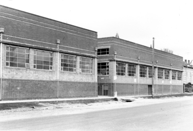
... in Albert Street was named "Flecknoe" in 1991, three years after... Street was named "Flecknoe" in 1991, three years after Flecknoe's ...Kenneth Joynson Flecknoe joined the Ballarat School of Mines Council in 1979 becoming its 11th President in 1981. He joined the Ballarat Courier newspaper in 1953 as company secretary, becoming General Manager in 1966. Flecknoe joined the board of directors in 1968 and was managing director from 1969 until his retirement in 1987. Flecknoe was chairman of the Ballarat Broadcasters Pty Ltd (3BA), of the gateway Publishing Company which published newspapers in Ararat and Stawell and of the Ballarat Publishing Company which published Ballarat News, and was formerly deputy chairman of associated Broadcasting Services Ltd (BTV6 Ballarat and GMV Shepparton). He was also Chairman of the advisory board of Ballarat's St John of God Hospital. Flecknoe's contribution to the Royal South Street Society, of which he was a past president, and a committee member since 1961, was rewarded with life membership. He was also a life member of the Ballarat Historical Park Association (Sovereign Hill). The Ballarat School of Mines building in Albert Street was named "Flecknoe" in 1991, three years after Flecknoe's death.Three photographs showing a Ballarat School of Mines building on Albert Street. .1) Ballarat School of Mines Building, Albert Street .2) View of Carpentry Building looking towards Albert Street .3) Building on the Ballarat School of Mines Building (Possibly the former caretaker's cottage), near Albert Streetballarat school of mines, albert street, flecknoe, carpentry, vocational skills, ken flecknoe, flecknoe building -
 Federation University Historical Collection
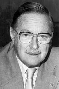
Photograph - Black and White, Ken Flecknoe
... in Albert Street was named "Flecknoe" in 1991, three years after... Street was named "Flecknoe" in 1991, three years after Flecknoe's ...Kenneth Joynson Flecknoe joined the Ballarat School of Mines Council in 1979 becoming its 11th President in 1981. He joined the Ballarat Courier newspaper in 1953 as company secretary, becoming General Manager in 1966. Flecknoe joined the board of directors in 1968 and was managing director from 1969 until his retirement in 1987. Flecknoe was chairman of the Ballarat Broadcasters Pty Ltd (3BA), of the gateway Publishing Company which published newspapers in Ararat and Stawell and of the Ballarat Publishing Company which published Ballarat News, and was formerly deputy chairman of associated Broadcasting Services Ltd (BTV6 Ballarat and GMV Shepparton). He was also Chairman of the advisory board of Ballarat's St John of God Hospital. Flecknoe's contribution to the Royal South Street Society, of which he was a past president, and a committee member since 1961, was rewarded with life membership. He was also a life member of the Ballarat Historical Park Association (Sovereign Hill). The Ballarat School of Mines building in Albert Street was named "Flecknoe" in 1991, three years after Flecknoe's death.Photographic portraitken flecknoe, ballarat school of mines, ballarat school of mines council, ballarat courier -
 Surrey Hills Historical Society Collection
Photograph, Annie Barton and Jocelyn Cerini, 1928, c1928
... in 1901 the street name changed - it was originally Kent Street... the street name changed - it was originally Kent Street. John Barton ...The photo was taken in 1928 and the young child is definately Jocelyn Francesca Cerini, elder daughter of Natale Cerini and his wife Ethel (MS: Swan). The Cerini family lived at 215 Union Road. Most likely that the photo was taken in the back garden of 215 Union Road which backs onto 11 and 13 Barton Street. Thus the houses in the background are the two houses occupied by Barton family members - No 11 and 13 Barton Street, Surrey Hills. The photo card index compiled by Jocelyn Hall (nee Cerini) identifies the elderly lady as Miss Annie Barton, sister of Rev John Barton, second minister of Wyclif Congregational Church. She was a nurse. However the age of Jocelyn (born 1922) makes it more likely that this is Mrs Annie Eliza Barton (nee Duncan), wife of the Rev John Barton and mother of James Duncan Barton, John Saxon Barton, Ida Grace Barton, Albert Edward Barton, Annie Barton and Harold Arthur Barton. Annie Eliza (Duncan) Barton was born in 1845 and died on 16 Jan 1933, which is consistent with the age of the lady pictured. By the time this photo was taken her husband, the Rev John Barton (1844-1919) had died. He was minister of the Wyclif Church in 1896 and continued in that role until 1907. After a further appointment John Barton retired and continued to worship at Wyclif, residing at 13 Barton Street. On Federation in 1901 the street name changed - it was originally Kent Street. John Barton was born in 1845 in Ainsdale, Lancashire, son of James Barton and Ann Rimmer and grew up in Formby - the name later given to No 13 Barton Street. His family appear to have remained in the UK. He married Ann Eliza Duncan in 1872 in Queensland. Of the 2 daughters who were nurses: Ida Grace Barton (b 1877) did not marry. She trained at the Homeopathic Hospital (later Prince Henry's Hospital), graduating in 1909. Annie Barton (b 1883, Geelong) trained at the Melbourne Hospital. She was Matron AANS during WW1 in charge of the Base Hospital (Military) in St Kilda Road. She married Dr John Hodgson Nattrass. She died in 1965 at Caulfield. John and Ann Eliza Barton are buried in Box Hill Cemetery - C0044.A black & white photo of an elderly lady seated in a cane chair in an outdoor setting. To one side is a young girl also seated in a chair and holding a doll; to the other side is a doll's pram containing another doll. The background is indistinct but appear to be houses.clothing and dress, 1928, miss jocelyn francesca cerini, mrs jocelyn hall, annie eliza duncan, annie eliza barton, box hill cemetery, rev john barton, jocelyn cerini, dolls, 215 union road -
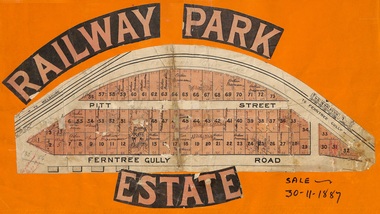 Ringwood and District Historical Society
Flyer, Subdivision sale poster - Railway Park Estate, Ringwood, Victoria - 1887
... Street, Ringwood. Handwritten names associated with allotments... Street, Ringwood. Handwritten names associated with allotments ...Collage of clipped lettering and map pasted to orange coloured card depicting Railway Park Estate subdivision sale. Handwritten names associated with allotments and notation of sale date - 30 November, 1887. Subdivision plan with pink shading highlighting 73 allotments in Ferntree Gully Road (later Bedford Road) and Pitt Street, Ringwood. Handwritten names associated with allotments include Arthur Wiseman, T. Grant, J.J. Miller, M. Dickson, G.G. Miller, J. Frost, J.K. Turnbul, J.W. Davis, William Aldridge. Additional hand-drawn map on cardboard backing labeled Allotments for Sale at Ringwood - Part of Crown Allotment 17. -
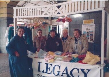 Melbourne Legacy
Photograph - Photo, Legacy Appeal, Badge Week Stall, 1990
... Street Station in 1990. Widows met regularly at Legacy House...Melbourne Legacy 293 Swanston Street Melbourne melbourne ...Two photos of widows with a handcrafts stall at Flinders Street Station in 1990. Widows met regularly at Legacy House for craft gatherings lessons. Some of the items the Widows produced were entered into an annual craft contest and exhibition. Many items were also donated to the annual Badge Week stall that widows organised. The stall was often outside Legacy House but in these photos from 1990 the stall was set up at Flinders Street Station. The ladies names aren't known.A record of the fundraising for the Legacy Appeal in 1990 by the widows clubs.Colour photo x 2 of widows selling items at Flinders Street Station in 1990.legacy appeal, fundraising, badge week, widows, craft -
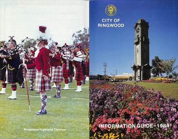 Ringwood and District Historical Society
Booklet, City of Ringwood Information Guide - 1984, 1984
... of Parliament 25 Parking Signs and Street Names 35 Pedestrian Hazards 36... on Wheels 14 Members of Parliament 25 Parking Signs and Street Names ...Community information booklet issued by City of Ringwood for 1984 - covering the facilities and activities of the Ringwood Council and other local organisations and associations.CONTENTS: (page no.) Building - General Information 23 By-Laws/Traffic Regulations 22 Canterbury Road Railway Bridge Widening 34 Commissioners for Taking Declarations and Affidavits 24 Council Elections 11 Council Representatives 1983/1984 7 Council Structure. 10 Deferment of Rates 11 Emergency Telephone Numbers 59 Employment Initiatives Programme 32 European Wasps 26 Facilities for Disabled Persons 15 From the Chief Executive Officer 8 Garbage 20 Genera] Use Buildings 39 Historical Museum 29 Home Help Service 14 Immunisations - Health Care 12 Immunisation Programme - 1984 13 Justices of the Peace 23 Library Service for Senior Citizens 15 Maintenance of Facilities 34 Management Executive 9 Mayor’s Message – Cr. F.J. Corr 2 Meals on Wheels 14 Members of Parliament 25 Parking Signs and Street Names 35 Pedestrian Hazards 36 Pensioner Rate Assistance Scheme 12 Property Records 11 Rates 11 Re-Cycling of Waste 21 Ringwood Centre (Hostel) for the Frail Aged 17 Ringwood Cultural Centre 40 Ringwood Festival 28 Ringwood Golf Course. 36 Ringwood Highland Carnival 28 Ringwood Lake Reserve 29 Ringwood Library 17 Shopping Centre Studies 38 Staley Gardens 32 Standing Committees of Council 6 Swimming Centre 37 Welfare and Community Services 41 rinx -
 Melbourne Tram Museum
Ephemera - Ticket, Melbourne & Metropolitan Tramways Board (MMTB), MMTB 1 1/2d tickets, 1930's
... the lines and between streets. Has the full name of the MMTB one.... On the rear has the availability listing the lines and between streets ...Single or one off of pre purchased or prepaid ticket one of a strip of MMTB 1 1/2d tickets with an "R" in the top right hand corner of both sides - fawn colour. Check ticket required to be issued with a fare. On the rear has the availability listing the lines and between streets. Has the full name of the MMTB one side and "M&MTB" on the other side. See Reg Items 1152, 2486 and 3341 for similar tickets of other values. See Reg Item 5854 for a set of research notes.trams, tramways, tickets, mmtb, pre-paid tickets -
 St Kilda Historical Society
Photograph
... , Aged 36 Years. Burnett Street, St Kilda, is named after him... Street, St Kilda, is named after him. The street was created by F ...The Melbourne General Cemetery opened in June 1853. The first male buried there was John Alexander Burnett, chief clerk to the mercantile firm of Dalgety, Borradale & Co. The headstone reads: In Memory of James Alexander Burnett, Merchant, Who Died 25 May 1853, Aged 36 Years. Burnett Street, St Kilda, is named after him. The street was created by F. G. Dalgety when he sold his land in St Kilda (12 acres known as 'Dalgety's Paddock') on 12 April 1853.Colour photographIst Grave in Melbourne Cemetery of St Kilda identity John Alexander Burnettst kilda, john alexander burnett, melbourne cemetery -
 Warrnambool and District Historical Society Inc.
Book, Peloubet's Select notes 1895. 1898. 1904, 1895, 1898, 1904
... and James, operated a produce export business in Kepler Street under..., operated a produce export business in Kepler Street under the name ...These are three volumes of Peloubet’s Select Notes. The book contents are described as ‘Inductive, Suggestive, Explanatory, Illustrative, Doctrinal and Practical’. The books were issued as curriculum material for Sunday Schools and were first published in the mid 1870s and continued to be published for the next 100 years. These three volumes belonged to M. P. McMeekin and this is presumed to be Margaret Parker McMeekin (1868-1948), the daughter of John McMeekin and Isabella Parker of Warrnambool. John McMeekin was the Rate Collector and Inspector and then the Valuer for the Warrnambool Shire in the 1860s, 70s and 80s. Two sons, William and James, operated a produce export business in Kepler Street under the name of McMeekin Brothers and another son, Charles was an auctioneer in Warrnambool. It is surmised that Margaret McMeekin was a Sunday School teacher either in Warrnambool or Port Fairy. These books are of interest as examples of what was taught in Sunday Schools in the late 19th and early 20th centuries. They are also of interest because they belonged to Margaret McMeekin, a member of a prominent family in Warrnambool at that time. These are three books of a religious nature written by F. and M. Peloubet and published in 1895, 1898 and 1904. .1 A hard cover book of 346 pages with a greenish brown cover and gold lettering on the spine. Two blue stamps of the Warrnmbool & District Historical Society and a handwritten name are on the first page .2 A hard cover book of 344 pages with a brown cover and gold lettering on the spine. Two blue stamps of the Warrnambool & District Historical Society are on the first and last page. The cover has worn edges. .3 A hard cover book of 358 pages with a greenish brown cover and gold lettering on the spine. There are two blue stamps of the Warrnambool & District Historical Society on the first and last page. There is a black and white full page plate at the beginning of the book and this is protected by a piece of tissue. ‘M.P. McMeekin, Port Fairy’ (1895 volume) sunday schools, margaret mcmeekin, warrnambool history -
 Kew Historical Society Inc
Plan - Subdivision Plan, J Hurrey, Section 115 in the Parish of Boroondara Near Richmond Bridge, 1853
... named streets, the section was located on the east side of Burke... named streets, the section was located on the east side of Burke ...Despite the plans claims that it is a subdivision near the Richmond Bridge, Section 115 was located at what is now Camberwell Junction. While the plan only lists government roads rather than named streets, the section was located on the east side of Burke Road, stretching up the hill from the current Junction. Research on Trove, conducted by Kerry Fairbank, discovered an advertisement for unsold lots in Section 115 which clarifies the extent and location of subsequent land sales in the original section. The original article can be viewed through the link in the catalogue record. The interesting link to Kew is the reference to James Beavan as the purchaser of lots 14 and 15. The historian Gwen McWilliam has notes that a Mr Beavan changed his name from Bevan. The Bevans were descendants of the Derricks family of Kew. This subdivision plan is the earliest original map or plan in the collection which shows parts of what is now the City of Boroondara, dating from circa 1853. It provides important information for researchers on subsequent subdivisions following the original land sales in [Camberwell] Boroondara. The site, on the east side of Burke Road is a highly-significant and historic site. This is believed to be the only extant copy of the subdivision in public collections.A small plan on parchment listing 28 lots, between one and two acres each, for sale in Section 115 in the Parish of Boroondara, dating from 1853 when the portion was subdivided.Obverse: Lot 16 "Joseph Duval", Lots 14 & 15 "James Beavan". Other annotations (measurements) are unreadable. Reverse: "KH-981 / Section 115 in the Parish of Boroondara / Near Richmond Bridge / 1640T. / J Duval / 14-15 J. Beavanparish of boroondara, subdivision plans - camberwell, section 115 - boroondara, subdivision plans -- camberwell (vic), riverscape road, burke road, camberwell junction -
Bendigo Historical Society Inc.
Administrative record - Share Register, unknown Company, 1937 - 1946
... Collins Street, Melbourne. No identifying name on cover. Pages... and Stationers, 404 Collins Street, Melbourne. No identifying name ...Blue hard cover register, maroon binding. Inside front cover, sticker: Cook and Heathcote, Printers and Stationers, 404 Collins Street, Melbourne. No identifying name on cover. Pages have been removed from front of register. First page in register has register of cheque numbers and dividend amount paid, dating from 19th November 1937 to 30th April 1946. Following pages, record in alphabetical order, the names of shareholders, cheque number paid and dividend per share. The Share Register is part of the Margaret Roberts Collection of mining documents.margaret roberts -
 Greensborough Historical Society
Certificate of Title, Supreme Court of Victoria (Probate Division) et al, Certificate of Title Vol. 2567 Fol. 294, Vol. 3134 Fol. 605, 22/05/1895
... McDowell Street); Title Vol. 3134 Fol. 605 in the name of Adolphe... McDowell Street); Title Vol. 3134 Fol. 605 in the name of Adolphe ...Title Vol. 2567 Fol. 294 in the name of The Greensborough Estate Company Limited, 164 acres four and a half perches, being part of Crown Portion 17 Parish of Keelbundora, County of Bourke. Dated 22nd May 1895. Northern boundary Greensborough Road (now Grimshaw Street), Southern boundary Nell Street, Eastern boundary Plenty River, Western boundary road (now named McDowell Street); Title Vol. 3134 Fol. 605 in the name of Adolphe Frederic Seelenmeyer, land as described above, LP 4759 and transfers and other instruments to 9 March 1948Folder containing two Certificates of Title (3p. + 9 p.) and twenty pages of miscellaneous documents, including historical summary, brief biography of A. F. Seelenmeyer, two Death Certificates and photocopied extracts from probate documents, as listed in table of contents, ed. by Peter Simmenauergreensborough, greensborough estate company limited, grimshaw street greensborough, plenty river, nell street greensborough, mcdowell street greensborough, adolphe frederic seeley, formerly seelenmeyer, adolfe frederic seelenmeyer -
 Bendigo Historical Society Inc.
Photograph - Sepia family photograph
... of Mitchell and King Street, which was later named the Bendigo... Street, which was later named the Bendigo Portrait rooms ...Frederick de Kock first advertised as a teacher of French situated in Mr N Caire's photographic Studio, View Place. In 1882 he began teaching hand painting on ceramics. In 1883 he advertised as a photographer with his own studio on the corner of Mitchell and King Street, which was later named the Bendigo Portrait rooms. In December 1887 Mrs De Kock sold all her goods prior to a move to Sydney. In 1888 Frederick advertised as a representative of the Enlargement Company who was visiting Bendigo to take orders. This information suggests that this photograph was taken between 1883 and 1887.Sepia family photograph of three girls and one boy, date and family name unknown. Siblings dressed for the photograph, youngest child the son carries a walking stick. Photograph by F. de Kock & Co., photographic artists located at corner of Mitchell and King Streets.siblings, family group -
 Victoria Police Museum
Police Stations (Altona)
... Galvin Street, Altona. Galvin Street was names after S/C Michael... Galvin Street, Altona. Galvin Street was names after S/C Michael ...Altona is a suburb of Melbourne, 13 km south-west of Melbourne's CBD and located within the City of Hobsons Bay Altona Police Station opened as a temporary police station in 1919 in the Melbourne District. It was on the corner Sargood and Blyth Streets. It was staffed by one 1st Constable. The original police station was in a small room attached to the front of a 5-roomed weather-board dwelling with an iron roof on land measuring 66' x 165'. There was also a kitchen, vestibule, wash-house, office, one W.C. and a lock-up. In 1929 it became part of the Bourke District. On 31 March 1958 it moved into newly built government premises at 51-53 Blyth Street, on the corner of Bent Street. The building consisted of a cream brick veneer police residence and police station with cell. Staff was increased to a Sergeant in Charge and 3 Constables. A new police station was opened in Altona North on 7th October 1979. The Altona Police Station remained as a sub-station for a few a short time until the building was sold. July 2019 - a new police station is being constructed at 1 Galvin Street, Altona. Galvin Street was names after S/C Michael Arthur Galvin, 3651, who was appointed on 5 Jan 1886 and resigned on 4 Dec 1913. He was Werribee Shire President 1926-1927 and 1940-1941 8 black and white photos of new police station, 1963police stations; altona police station -
 Dandenong & District Historical Society
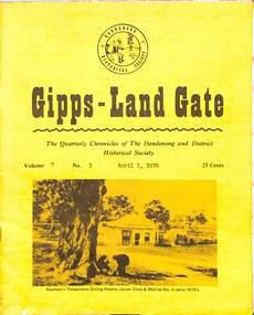
Journal, Dandenong & District Historical Society, Gipps-Land Gate Vol.7 No.3, 1979
... Were Here Even In 1858! Londsdale Street Land For £££ The Name... In Dandenong The Speculators Were Here Even In 1858! Londsdale Street ...An interesting group of Early Dandenong Personalities, Places and EventsA5 size publication of the Gipps-Land Gate, April 1979, 16 pages, featuring an old picture of Dandenong on the cover. Keeping Posted The Beginnings Of Golf In Dandenong The Speculators Were Here Even In 1858! Londsdale Street Land For £££ The Name Of Griffith's Point Disappears Dandenong Granite Used In Princes Bridge Bid To Change Hampton Park's Name Fails A Cobb & Co Coach Driver From The Gold Era Harking Back 75 Years Ago Was This The Site Of Dandenong's First Market? A Day At The Eumemmerring Races Way Back in 1877 A Gippsland Railway Day To Be Remembered The Missing Link An interesting group of Early Dandenong Personalities, Places and Eventshotel history, early education in dandenong, interesting milestones, family histories -
 Kew Historical Society Inc
Plan, Melbourne & Metropolitan Board of Works : Borough of Kew : Detail Plan No.1301, 1910
... of the streets then named Effey and Maud Streets (now Swinton Avenue... on the plan: ‘Swinton’ on the corner of the streets then named Effey ...The Melbourne and Metropolitan Board of Works (MMBW) plans were produced from the 1890s to the 1950s. They were crucial to the design and development of Melbourne's sewerage and drainage system. The plans, at a scale of 40 feet to 1 inch (1:480), provide a detailed historical record of Melbourne streetscapes and environmental features. Each plan covers one or two street blocks (roughly six streets), showing details of buildings, including garden layouts and ownership boundaries, and features such as laneways, drains, bridges, parks, municipal boundaries and other prominent landmarks as they existed at the time each plan was produced. (Source: State Library of Victoria)This plan forms part of a large group of MMBW plans and maps that was donated to the Society by the Mr Poulter, City Engineer of the City of Kew in 1989. Within this collection, thirty-five hand-coloured plans, backed with linen, are of statewide significance as they include annotations that provide details of construction materials used in buildings in the first decade of the 20th century as well as additional information about land ownership and usage. The copies in the Public Record Office Victoria and the State Library of Victoria are monochrome versions which do not denote building materials so that the maps in this collection are invaluable and unique tools for researchers and heritage consultants. A number of the plans are not held in the collection of the State Library of Victoria so they have the additional attribute of rarity.Original survey plan, issued by the MMBW to a contractor with responsibility for constructing sewers in the area identified on the plan within the Borough of Kew. The plan was at some stage hand-coloured, possibly by the contractor, but more likely by officers working in the Engineering Department of the Borough and later Town, then City of Kew. The hand-coloured sections of buildings on the plan were used to denote masonry or brick constructions (pink), weatherboard constructions (yellow), and public buildings (grey). Throughout its history, the land in what is known today as Studley Ward of the City of Boroondara has been subject to continuing subdivision. This is evident in Plan 1301, where later hands have modified the original map to include streets created subsequent to the printing of the plan in 1904. Other annotations such as the ‘Reserved for Road Purposes’ beside the Yarra never eventuated. The plan continued to be modified to at least 1953, when a later hand noted that a particular site was ‘Property site P. McIntyre house’ in Swinton Avenue. Two significant houses in the area are outlined on the plan: ‘Swinton’ on the corner of the streets then named Effey and Maud Streets (now Swinton Avenue) and ‘Fairhaven’ [unnamed] in Stevenson Street. The gardens of the two David Syme owned mansions of ‘Blythswood’ and ‘Rockingham’, stretching down to the River Yarra, are also represented.melbourne and metropolitan board of works, detail plans, mmbw 1301, cartography -
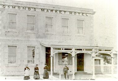 Port Fairy Historical Society Museum and Archives
Photograph
... on the opposite side of William Street hence the name Market Inn. William... on the opposite side of William Street hence the name Market Inn. William ...Market Inn William Street Port Fairy. William and Emma Osmond with two small children arrived in Belfast in 1852 as assisted migrants assigned to R.H.Woodward. Two years later William was rated for a two room stone house in William Street. By 1868 William was in business as a butcher and was the holder of a Beer and Colonial wine licence for his home which now numbers eight rooms. The licence having been granted he opened the Volunteer Arms there which he operated for two years whilst he had built, the two storied stone building next door to take advantage of the fact that a livestock sale yards was operating on the opposite side of William Street hence the name Market Inn. William died in 1876 and his sons continued to run the hotel until 1916 when the building was sold and the licence transferred to Harold Revell a retired farmer. The licence was revoked in 1918 and the building became a private dwelling. Black and white Photograph of Two story market hotel with verandah over right side 3 females and a male on footpathhotel, william street, h revell, william osmond, emma osmond, market, inn -
 Kew Historical Society Inc
Plan, Melbourne & Metropolitan Board of Works : Borough of Kew : Detail Plan No.1581, 1904
... mansions in Walpole Street, one named on the plan as ‘Gnarlbine... churches in Walpole Street. While the mansion ‘Illapa’ in Princess ...The Melbourne and Metropolitan Board of Works (MMBW) plans were produced from the 1890s to the 1950s. They were crucial to the design and development of Melbourne's sewerage and drainage system. The plans, at a scale of 40 feet to 1 inch (1:480), provide a detailed historical record of Melbourne streetscapes and environmental features. Each plan covers one or two street blocks (roughly six streets), showing details of buildings, including garden layouts and ownership boundaries, and features such as laneways, drains, bridges, parks, municipal boundaries and other prominent landmarks as they existed at the time each plan was produced. (Source: State Library of Victoria)This plan forms part of a large group of MMBW plans and maps that was donated to the Society by the Mr Poulter, City Engineer of the City of Kew in 1989. Within this collection, thirty-five hand-coloured plans, backed with linen, are of statewide significance as they include annotations that provide details of construction materials used in buildings in the first decade of the 20th century as well as additional information about land ownership and usage. The copies in the Public Record Office Victoria and the State Library of Victoria are monochrome versions which do not denote building materials so that the maps in this collection are invaluable and unique tools for researchers and heritage consultants. A number of the plans are not held in the collection of the State Library of Victoria so they have the additional attribute of rarity.Original survey plan, issued by the MMBW to a contractor with responsibility for constructing sewers in the area identified on the plan within the Borough of Kew. The plan was at some stage hand-coloured, possibly by the contractor, but more likely by officers working in the Engineering Department of the Borough and later Town, then City of Kew. The hand-coloured sections of buildings on the plan were used to denote masonry or brick constructions (pink), weatherboard constructions (yellow), and public buildings (grey). The streets and built structures in this plan were surveyed in 1903 and released to contractors in 1904. In addition to the designation of building types by colour, the plan includes detailed descriptions of land use and ownership. While many buildings remain from this period, a number of the buildings represented have been demolished including the original Kew Town Hall, and the Congregational and Roman Catholic churches in Walpole Street. While the mansion ‘Illapa’ in Princess Street is still extant – now part of ‘Rylands’ – the neighbouring mansion ‘Elsmere’ was demolished some decades ago. Rivalling Illapa and Elsmere in size were two mansions in Walpole Street, one named on the plan as ‘Gnarlbine’. Over time, Kew Junction and the south side of High Street have been reconfigured and widened, so that the commercial buildings on the corner of Princess and High Street no longer exist. A surprising feature of this part of central Kew to the northwest of Kew Junction is the amount of vacant land. In a number of cases, this land is noted by the contractor as used for vegetable gardens.melbourne and metropolitan board of works, detail plans, maps - borough of kew, mmbw 1581, cartography -
 Bendigo Historical Society Inc.
Newsletter - The Grapevine Cuttings by Rob Upson, 1998 to 2000
... Rosalind Park 10828.82 Bendigo Street Names 10828.83... Rosalind Park 10828.82 Bendigo Street Names 10828.83 ...Rob Upson became a volunteer at the Bendigo Visitor Centre in 1998. The Staff produced a monthly newsletter called ‘The Grapevine’. Being reasonably new to Bendigo, Rob became interested in its history and began writing articles to share with the volunteers. He called them ‘Grapevine Cuttings’ under the pen name of ‘Merlot’. Rob wrote about 90 articles over a period of 12 years until ‘The Grapevine’ was finally pruned and shutdown. Rob is a valuable volunteer for the Bendigo Historical Society.Sixty Five Newsletters in PDF format from the Grapevine collection that cover the following historical items: Grapevine Newsletters by Rob Upson (Bendigo Historical Society) 10828 Index 10828 Index - Parent Document (This Page) 10828.00 ‘Objection your Honour’ 10828.01 Bendigo’s Gold Volume 10828.02 Harry Boyle (Cricketer) 10828.03 Ellen Clacy on the Goldfields 10828.04 Gold Fever and Vandemonians 10828.05 The Railway to Bendigo (Part 1 and 2) 10828.07 The Pioneer’s Grave at Maiden Gully 10828.08 The First Parliamentary Election, Bendigo 1855 10828.09 The Origin of Place Names 10828.10 The Tram (Parts 1 to 4) 10828.13 W.D.C. Denovan 10828.14 Knipe’s Castle 10828.15 John Hanlon Knipe 10828.16 1st January 1900 in Bendigo 10828.17 William Gay – Bendigo Poet 10828.18 St. Aidan’s Orphanage 10828.19 The Year 2000 – a Prediction from 1967 10828.20 Dr. Henry Backhaus 10828.21 St. Kilian’s Catholic Church 10828.22 S.T. Gill – Goldfields Artist 10828.23 Cobb and Co. 10828.24 ‘The Lights of Cobb and Co.’ by Henry Lawson 10828.25 Federation Celebrations – Sydney 1901 10828.26 The Australian Flag of Stars 10828.27 Old Treasury Building – Melbourne 10828.28 Key Dates in Bendigo’s First 50 Years 10828.29 The March from Robe to Bendigo and China’s Long March 10828.30 A Goldfields Quiz 10828.31 Did You Know That ………..? 10828.32 The Weekly Times 1869 10828.33 Mark Twain in Australia 10828.34 Bendigo’s Jewish Synagogue 10828.35 Sly Grog on the Goldfields 10828.36 A Brief History of Breweries in Australia 10828.37 The Breweries of Bendigo 10828.38 The Cohn Brothers of Bendigo 10828.39 Mary McCarthy – aged 114 10828.40 Langley Hall and Bishopscourt 10828.41 William ‘Bendigo’ Thompson 10828.42 Lachlan MacLachlan 10828.43 ‘Said Hanrahan’ by John O’Brien 10828.44 The Origin of Sandhurst 10828.45 Lister House 10828.46 Arthur Thomas Woodward 10828.47 The Students of Arthur Thomas Woodward 10828.48 Henry Leggo 10828.49 Chiko Rolls and Four ‘n Twenty Pies 10828.50 HMVS Nelson and Victoria’s Navy (Parts 1 and 2) 10828.52 Anthony Trollope in Australia (Part 1 to 3) 10828.55 Regional Towns of Victoria – a Quiz 10828.56 Exploration and Settlement of Victoria (Parts 1 and 2) 10828.58 The Major Mitchell Expedition into Victoria (Parts 1 to 3) 10828.61 The Gold Rush (Part 1 and 2) 10828.63 The Road to the Diggings (Part 1 and 2) 10828.65 Harold Desbrowe-Annear (Part 1 and 2) 10828.71 Nom de Plumes 10828.72 The New Zealand Gold Rush 10828.73 Ernst Mueller and Ettore Cadorin 10828.74 Sir John Monash 10828.75 P & O Ships 10828.76 Rosalind Park 10828.82 Bendigo Street Names 10828.83 A Constitutional Proposal and Early Bendigo Vineyards 10828.84 Ferdinand von Mueller 10828.85 John Boyd Watsonhistory, bendigo, grapevine cuttings