Showing 10951 items matching " land"
-
 Greensborough Historical Society
Plan, Plan of Manatunga Circuit Greensborough subdivision, 1970_
Plan of Manatunga Circuit subdivision. Prepared by O'Connor and Beveridge (land surveyors) for Development Underwriting (developers). Plan of subdivision. Part of Crown Portion 3. Parish of Nillumbik, County of Evelyn.An original example of a subdivision plan in the expanding suburb of Greensborough. The 1960s and 1970s saw this area develop from a rural farming area to a suburb.Plan of subdivision. Printed on buff paper, hand coloured. Mounted on cardboard. Includes 2 small cards attached.Various handwritten comments. Small cards from Survey Branch, Office of Titles.greensborough, manatunga circuit, diamond creek road, plenty river drive -
 Greensborough Historical Society
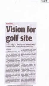
Newspaper Clipping, Diamond Valley Leader, Vision for golf site, 02/08/2017
La Trobe University has broken its silence over the future of Strathallan Golf Course, revealing a vision for the land that includes residential development, sports facilities and bike trails.News article 1 page, black text.strathallan golf club, la trobe university, darebin council, bundoora -
 Greensborough Historical Society
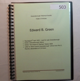
Folder, Edward B. Green, 1853o
Contents: Land sale for Greensborough (The Argus 1853); Article: Greensborough history; Article: The Greens of Barham Station NSW; letter to Shire council from descendant of E B Green. History of the origins of Edward Bernard Green after whom Greensborough was named.20-page plastic binder, spiral bound, clear cover. Contains documents relating to Edward B. Green and family.Collected by Greensborough Historical Society. Folder commenced 2012.greensborough, edward bernard green -
 Ringwood and District Historical Society
Archive - Parent Record, Ringwood Bowling Club / City of Ringwood Bowls Club Archive Collection of Photographs and Documents 1929 - current (Parent Record)
1929 saw the establishment of the Ringwood Bowls Club initially located on the land now occupied by the Eastland Shopping Centre. It moved to its current location in Loughnan Road, Ringwood in 1997.This is the parent record for the large archives collection of the Ringwood Bowls Club formerly the City of Ringwood Bowls Club), consisting of various photos and documents from the club's beginning in 1929. Individual items fall in the VC Reference Number range 30000 - 31999 and where possible are grouped by year. city of ringwood bowls club, ringwood bowling club, ringwood bowls club, lawn bowls, bowling -
 Ringwood and District Historical Society
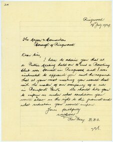
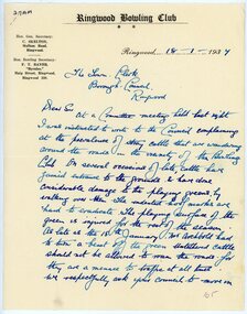
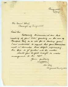
Letter, Citing Ringwood Bowling Club's formation and requesting Council for occupancy of Bamford's Park
1929 saw the establishment of the Ringwood Bowls Club initially located on the land now occupied by the Eastland Shopping Centre. It moved to its current location in Loughnan Road, Ringwood in 1997.Hand-written letter from the Hon. Secretary of the Ringwood Bowling Club to Borough of Ringwood Mayor and Councillors requesting the terms and conditions of occupying Bamford's Park. Dated 19th July 1929.city of ringwood bowls club, ringwood bowling club, ringwood bowls club, lawn bowls, bowling -
 Ringwood and District Historical Society
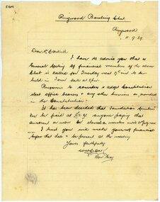
Letter, Inviting Mr McCaskill to Ringwood Bowling Club's meeting to adopt the Constitution and elect office bearers
1929 saw the establishment of the Ringwood Bowls Club initially located on the land now occupied by the Eastland Shopping Centre. It moved to its current location in Loughnan Road, Ringwood in 1997.Hand-written letter from the Hon. Secretary of the Ringwood Bowling Club to Mr McCaskill requesting attendance at next general meeting. Dated 11th September 1929.city of ringwood bowls club, ringwood bowling club, ringwood bowls club, lawn bowls, bowling -
 Ringwood and District Historical Society
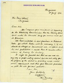
Letter, To Borough of Ringwood from Ringwood Bowling Club thanking for full access to Bamford Park
1929 saw the establishment of the Ringwood Bowls Club initially located on the land now occupied by the Eastland Shopping Centre. It moved to its current location in Loughnan Road, Ringwood in 1997.Hand-written letter from the Hon. Secretary of the Ringwood Bowling Club to Borough of Ringwood Council giving thanks for access to Bamford Park. Dated 18th September 1929.city of ringwood bowls club, ringwood bowling club, ringwood bowls club, lawn bowls, bowling -
 Ringwood and District Historical Society
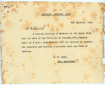
Letter, Inviting Mr McCaskill to Ringwood Bowling Club's meeting to inspect the premises and discuss opening date
1929 saw the establishment of the Ringwood Bowls Club initially located on the land now occupied by the Eastland Shopping Centre. It moved to its current location in Loughnan Road, Ringwood in 1997.Hand-written letter from the Hon. Secretary of the Ringwood Bowling Club to Mr McCaskill requesting attendance at next general meeting. Dated 8th January 1930.city of ringwood bowls club, ringwood bowling club, ringwood bowls club, lawn bowls, bowling -
 Ringwood and District Historical Society
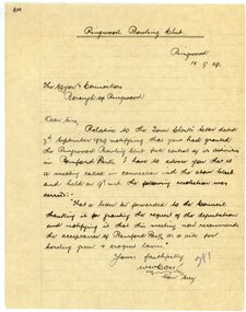
Letter, To Borough of Ringwood's Town Clerk from Ringwood Bowling Club re stray cattle
1929 saw the establishment of the Ringwood Bowls Club initially located on the land now occupied by the Eastland Shopping Centre. It moved to its current location in Loughnan Road, Ringwood in 1997.Hand-written letter to To Borough of Ringwood's Town Clerk from Ringwood Bowling Club re stray cattle. Dated 18th January 1937.city of ringwood bowls club, ringwood bowling club, ringwood bowls club, lawn bowls, bowling -
 Ringwood and District Historical Society
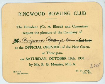
Print, Ringwood Bowling Club invitations to the openings of the bowling and croquet greens (1931-39)
1929 saw the establishment of the Ringwood Bowls Club initially located on the land now occupied by the Eastland Shopping Centre. It moved to its current location in Loughnan Road, Ringwood in 1997.Small invitation cards(1) The President, Cr A Blood, invites to official opening of new green on 10th October 1931 by RG Menzies MLA, (2) official opening of the bowling and croquet greens on 1st October 1932 and (3) opening of the green on 23rd September 1939.city of ringwood bowls club, ringwood bowling club, ringwood bowls club, lawn bowls, bowling -
 Ringwood and District Historical Society
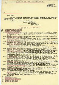
Document, From Borough of Ringwood Council, agenda for next council meeting on 23 July 1929
1929 saw the establishment of the Ringwood Bowls Club initially located on the land now occupied by the Eastland Shopping Centre. It moved to its current location in Loughnan Road, Ringwood in 1997.From Borough of Ringwood Council, agenda for next council meeting on 23 July 1929. Ringwood Bowling Club requesting conditions for use of Bamford Park as a bowling green.city of ringwood bowls club, ringwood bowling club, ringwood bowls club, lawn bowls, bowling -
 Ringwood and District Historical Society
Document, From Ringwood Bowling Club calling public meeting on 8th September 1929
1929 saw the establishment of the Ringwood Bowls Club initially located on the land now occupied by the Eastland Shopping Centre. It moved to its current location in Loughnan Road, Ringwood in 1997.From Ringwood Bowling Club calling public meeting on 8th September 1929. Dated 28th August 1929.city of ringwood bowls club, ringwood bowling club, ringwood bowls club, lawn bowls, bowling -
 Ringwood and District Historical Society
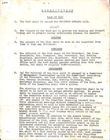
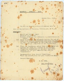
Document, Ringwood Bowling Club Constitution 1929 then amended in 1935
1929 saw the establishment of the Ringwood Bowls Club initially located on the land now occupied by the Eastland Shopping Centre. It moved to its current location in Loughnan Road, Ringwood in 1997.Ringwood Bowling Club Constitution first adopted on 17th September 1929 then amended on 31st July 1935 at a special general meeting. Signed by A Blood, President, and W Cock, Secretary.city of ringwood bowls club, ringwood bowling club, ringwood bowls club, lawn bowls, bowling -
 Ringwood and District Historical Society
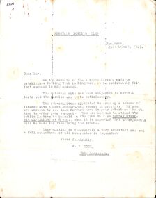
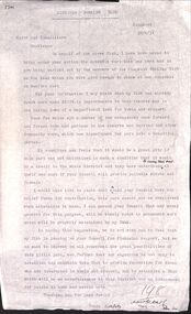
Letter, Ringwood Bowling Club requesting to meet councillors regarding the use of Bamford Park in 1929
1929 saw the establishment of the Ringwood Bowls Club initially located on the land now occupied by the Eastland Shopping Centre. It moved to its current location in Loughnan Road, Ringwood in 1997.Ringwood Bowling Club requesting to meet councillors regarding the use of Bamford Park in 1929city of ringwood bowls club, ringwood bowling club, ringwood bowls club, lawn bowls, bowling -
 Ringwood and District Historical Society
Letter, Ringwood Bowling Club wanting the council to ask the Electricity Commission for low tariff power in 1930
1929 saw the establishment of the Ringwood Bowls Club initially located on the land now occupied by the Eastland Shopping Centre. It moved to its current location in Loughnan Road, Ringwood in 1997.Two lettersRingwood Bowling Club wanting the council to ask the Electricity Commission for low tariff power in 1930city of ringwood bowls club, ringwood bowling club, ringwood bowls club, lawn bowls, bowling -
 Ringwood and District Historical Society
Letter, Ringwood Bowling Club wanting the council to ask the Electricity Commission for low tariff power in 1930
1929 saw the establishment of the Ringwood Bowls Club initially located on the land now occupied by the Eastland Shopping Centre. It moved to its current location in Loughnan Road, Ringwood in 1997.Ringwood Bowling Club wanting the council to ask the Electricity Commission for low tariff power in 1930city of ringwood bowls club, ringwood bowling club, ringwood bowls club, lawn bowls, bowling -
 Ringwood and District Historical Society
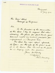
Letter, Ringwood Bowling Club wanting loan of wire fencing until the hedges grow in 1930
1929 saw the establishment of the Ringwood Bowls Club initially located on the land now occupied by the Eastland Shopping Centre. It moved to its current location in Loughnan Road, Ringwood in 1997.Two lettersRingwood Bowling Club wanting loan of wire fencing until the hedges grow in February 1930city of ringwood bowls club, ringwood bowling club, ringwood bowls club, lawn bowls, bowling -
 Ringwood and District Historical Society
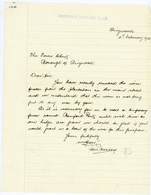
Letter, Ringwood Bowling Club asking the council for a grant for improvements to Bamford Park in 1930
1929 saw the establishment of the Ringwood Bowls Club initially located on the land now occupied by the Eastland Shopping Centre. It moved to its current location in Loughnan Road, Ringwood in 1997.Ringwood Bowling Club asking the council for a grant for improvements to Bamford Park in July 1930.city of ringwood bowls club, ringwood bowling club, ringwood bowls club, lawn bowls, bowling -
 Ringwood and District Historical Society
Document, Ringwood Bowling Club notices for the Annual General Meetings in August 1930, 1931 and 1932
1929 saw the establishment of the Ringwood Bowls Club initially located on the land now occupied by the Eastland Shopping Centre. It moved to its current location in Loughnan Road, Ringwood in 1997.Ringwood Bowling Club notices (3) for the Annual General Meetings on 14th August 1930, 18th August 1931 and 1st August 1932 at the Pavilioncity of ringwood bowls club, ringwood bowling club, ringwood bowls club, lawn bowls, bowling -
 Ringwood and District Historical Society
Letter, Ringwood Bowling Club asking the council for further support to provide shrubs and flowers for Bamford Park and the bowling green area in 1931
1929 saw the establishment of the Ringwood Bowls Club initially located on the land now occupied by the Eastland Shopping Centre. It moved to its current location in Loughnan Road, Ringwood in 1997.Ringwood Bowling Club asking the council for further support to provide shrubs and flowers for Bamford Park and the bowling green area in 1931. Also letter of thanks for 12 pounds, six weeks later.city of ringwood bowls club, ringwood bowling club, ringwood bowls club, lawn bowls, bowling -
 Ringwood and District Historical Society
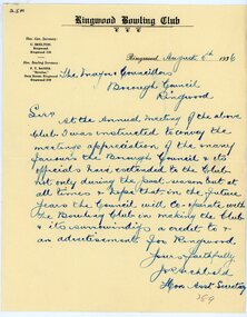
Letter, Ringwood Bowling Club thanking the Mayor and councillors for the many favours given to the Bowling Club, written in 1936
1929 saw the establishment of the Ringwood Bowls Club initially located on the land now occupied by the Eastland Shopping Centre. It moved to its current location in Loughnan Road, Ringwood in 1997.Ringwood Bowling Club thanking the Mayor and councillors for the many favours given to the Bowling Club, written in 1936city of ringwood bowls club, ringwood bowling club, ringwood bowls club, lawn bowls, bowling -
 Ringwood and District Historical Society
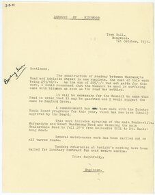
Letter, Borough of Ringwood engineer stating that a road between Warrandyte Road and Adelaide St has been completed in 1931
1929 saw the establishment of the Ringwood Bowls Club initially located on the land now occupied by the Eastland Shopping Centre. It moved to its current location in Loughnan Road, Ringwood in 1997.Borough of Ringwood engineer stating that a road between Warrandyte Road and Adelaide St has been completed in 1931. The proposed name of Bamford Grove.city of ringwood bowls club, ringwood bowling club, ringwood bowls club, lawn bowls, bowling -
 City of Moorabbin Historical Society (Operating the Box Cottage Museum)
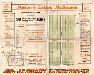
Flyer - Master's Estate, McKinnon
The end of WWI bought new interest in residential land. This sale must have been just before the electrification of the railway line from the city to Frankston which happened in 1922.Example of the progress of the Municipality of MoorabbinAdvertising flyer for auction of real estate sales - plan of building blocks for saleMaster's Estate, McKinnon - 99 Blocks - Agent: J. F. Bradymanchester road (now mckinnon road), tucker road, moylan street, lancaster street, preston street, real estate, bentleigh, mckinnon, moorabbin -
 City of Moorabbin Historical Society (Operating the Box Cottage Museum)
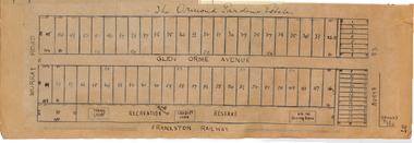
Plan - Ormond Garden Estate, Ormond, 1920
At the end of World War One, there was a renewed interest in residential land and a number of estates opened up in the Municipality of Moorabbin. Ormond Garden Estate was auctioned on Saturday 10 April, 1920.Example of the progress of the Municipality of MoorabbinHand drawn plan of subdivisionOrmond Garden Estatenorth road, glen orme avenue, murray road, ormond, auction, real estate -
 Expression Australia
Book, Financial Ledger Adult Deaf and Dumb Society of Victoria 1912-1923
The financial ledger of the Adult Deaf and Dumb Society of Victoria contains financial details of the land and building at Flinders Street and Blackburn including furnishing and fittings, bank accounts, expenditure etcSignificant as a record of the financial position of the Adult Deaf and Dumb Society of Victoria.Green and Red Cover; 34cmHx 22cmW -
 City of Warrnambool Rowing Club
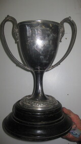
Trophy
Warrnambool Rowing Club had a boxing day regatta from 1885. The land beside the club was owned by the Rolfes who be-quested it to be an aged care home- presently called Lyndoch.Large silver colored cup (trophy) and a wooden base.Warrnambool Boxing Day Regatta Lyndoch Cup Maiden Eightsrowing, city of warrnambool rowing club, warrnambool rowing club, lyndoch, hopkins river -
 Sunbury Family History and Heritage Society Inc.
Photograph, c1999
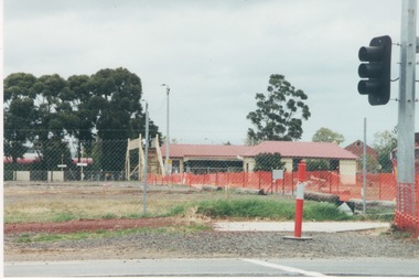
The open are in the foreground was part of railway land on the west side of Sunbury Station along Horne Street. The initial preparations to develop the area into a commercial and entertainment precinct were just commencing. The development that took place on this site was indicative of the growth that was taking place in Sunbury in the early 2000sA coloured photograph of an open area feed off with temporary netting in preparation for construction work. A set of traffic lights are on the RHS of the photograph and a station is in the middle distance.sunbury railway station -
 City of Kingston
Pamphlet - Colour, Farrow Falcon Press, Printers, Ozone Estate, Bluff Road, Hampton, c.1940
Sales plan for land in the suburb of Hampton (Highett), bounded by Bluff Road, Wickham Road, Peterson Street and June Street. Includes Morley Street, Follett Avenue, and Parrett StreetThe developing urban area of Highett within the City of Kingston. This land sale pamphlet illustrates the subdivision of land within the municipality and the changing demographic of the district as new houses are constructed close to infrastructure.Colour pamphlet advertising for private sale the Ozone Estate, Bluff Road Hampton. Incorporates a map of the estate bordered by Bluff Road, Wickham Road, June Street and Peterson Street including Morley Street, Follett Avenue and Parrett Street.Handwritten in grey pencil on reverse: Ozone Printed in purple ink on front top right-hand corner: Vendors are - Leslie Harcourt MacGowan, Esq / Neerim Road, Caulfield / & / Arthur Alfred Parrett, Esq / 311 Flinders Lane / Melbourneland sales, estate, hampton, highett -
 City of Kingston
Pamphlet - Colour, Farrow Falcon Press, Printers, Ozone Estate, Bluff Road, Hampton, c. 1940
Sales plan for land in the suburb of Hampton (Highett), bounded by Bluff Road, Wickham Road, Peterson Street and June Street. Includes Morley Street, Follett Avenue, and Parrett StreetThe developing urban area of Highett within the City of Kingston. This land sale pamphlet illustrates the subdivision of land within the municipality and the changing demographic of the district as new houses are constructed close to infrastructure.Colour pamphlet advertising for private sale the Ozone Estate, Bluff Road Hampton. Incorporates a map of the estate bordered by Bluff Road, Wickham Road, June Street and Peterson Street including Morley Street, Follett Avenue and Parrett Street.Handwritten in grey pencil on rear: Ozone Estateland sales, estate, highett, hampton -
Whitehorse Historical Society Inc.
Document - Research Notes, Anne Jones, Simpson Park, Mitcham, June 2021
The history of Simpson Park, Mitcham, plus email correspondence with Bill Simpson. Simpson Park was formerly known as Blooms Reserve.The history of Simpson Park, Mitcham, plus email correspondence with Bill Simpson. Simpson Park was formerly known as Blooms Reserve.non-fictionThe history of Simpson Park, Mitcham, plus email correspondence with Bill Simpson. Simpson Park was formerly known as Blooms Reserve.simpson park, morton william, simpson family, blooms reserve