Showing 2862 items matching "early buildings"
-
 Kiewa Valley Historical Society
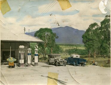
Photograph - Harris' garage Tawonga
Photograph taken from highway in Tawonga. Mt Bogong in the background. Note the early model vehicles and petrol pumps and signage.Photographic history of buildings in Tawonga pre 1940.Coloured photograph of garage owned by George Harris in Tawonga, opposite Hanna Paske pre 1940 (estimate only)Handwritten in ink on back - Opp. Hanna's Paske. George Harris owned the garage.tawonga, mt bogong, tawonga garage -
 Kiewa Valley Historical Society
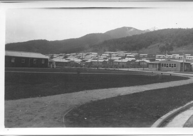
Photograph - Mount Beauty SEC Camp and Town, 1950
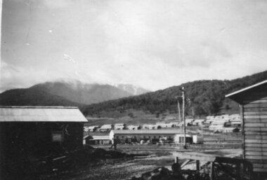
The new State Electricity Commission construction camp at the head of the Kiewa Valley was for workmen on the second power station in the project expected to be the most modern and best equipped in Australia… In contrast to the early Kiewa days of horses and canvas tents, the new camp, with its modern amenities, compared favourably with any country town. Administration of the Kiewa Scheme was moved from Tawonga to Mount Beauty in 1946. The first house in Mount Beauty, in Hollonds Street, was occupied by the co-op store manager from November 1946. The new Mess Hall at Mt Beauty was opened with much ceremony in early November 1946. The houses up to Nelse street were erected from 1946 onward and then the township was extended beyond Nelse Street in 1950. The workmen's camp was enlarged in 1950 to the extent of providing accommodation for a total of 1,200.Shows early construction in the town of Mt. Beauty surrounded by hills and farmland, with Mt Bogong in the background. Photo was taken in 1950 during the early stages of construction of the Kiewa Hydro electric SystemBlack and white photograph of Mt Beauty township in 1950 showing original workers buildings. Photograph has a .5cm white border around the photo.Handwritten on back of photograph in blue ink - SEC Camp and Town Mt Beauty 1950mt beauty, secv, mt beauty workmen's camp -
 Kiewa Valley Historical Society
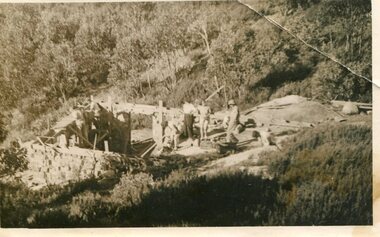
Photographs x 2 - Clover Dam, Circa 1940's
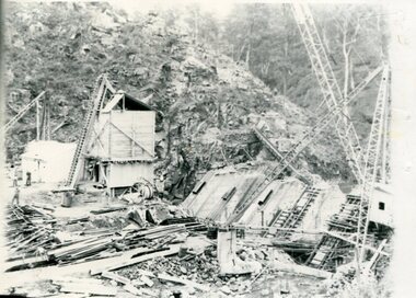
... document early engineering and building techniques used ...As part of the push to cut electricity costs and diversify supply, the Victorian Government (circa 1930) implemented the conversion strategy from mainly brown coal supply to hydro - electricity. The Kiewa Hydroelectric Scheme became the largest scheme of its kind in the State Of Victoria and the second largest scheme in Australia. Clover Dam and Power Station were built by the State Electricity Commission of Victoria as part of the Kiewa Hydro Electric Scheme from the late 1930's to the early 1940's. This dam was constructed to supply water to feed four turbines (62 mega watts) at the West Kiewa Power Station. This was at the forefront of sustainable "Green" energy. Costs associated with power supplies is still a major incentive of governments, however environmentally friendly alternatives such as wind and nuclear have also made inroads. The Kiewa valley and its surrounding alpine catchment were looked at(Victorian State Government), from the beginning of the twentieth century as a source of alternate power for an ever-increasing demand for electricity by growing population and heavy industrial areas within Melbourne City and State regions. Construction of dams, such as Clover Dam provided the large quantity holding areas of water required to turn the turbines at the various power stations to provide the electricity needed. The impact of these controls by moderating water run-off from the alpine regions is beneficial in reducing flooding from thawing of snow on the alps. This by-product allows agriculture and grazing to be less vulnerable to seasonal flooding thereby resulting in a more stable annual production level. Photographs also document early engineering and building techniques used in the construction of dams and power stations during the 1940’s and 1950’s. Note the lack of safety equipment and suitable work attire worn by construction workers on the sites 1. Black and white photograph of Clover Dam under construction. Has a .5cm white border around photo 2. Black and white photograph of Clover Dam under construction showing workmen at work. Has a .5cm white border around photo Written in pencil on back of both photographs - Clover Damclover dam, secv -
 Kiewa Valley Historical Society
Photographs x 2 - Mount Beauty Infant Welfare Centre, February 1994
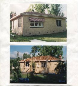
... . The photographs are an historical record of early buildings in the Mt ...During the 1950's, Mt Beauty's population was rapidly increasing due to the post war baby boom and because there was a young workforce moving into the area due to the opportunity available for work on the construction of the Kiewa Hydro Electric Scheme. Maternal Infant Welfare Centre Sisters conducted regular check-ups on babies to ensure they were feeding well, gaining weight and reaching appropriate milestones for their age.Infants and young children in the Kiewa Valley area continue to be monitored by the Maternal Health Nurses to ensure their healthy development. The photographs are an historical record of early buildings in the Mt Beauty area, their uses and how they have changed to meet the changing needs of the community.2 x colour photographs of renovations to Mt Beauty Infant Welfare Centre. Mounted on white A4 copy paperPrinted at bottom of page underneath photos - Mt Beauty Infant Welfare Centre February 1994. Replacement of tile roof with Colourbond corrugated iron and construction of covered entry porch.mt beauty, infant welfare centre -
 Kiewa Valley Historical Society
Photograph - Building of Myrtleford Ski Club
Myrtleford Ski Club is a non-commercial, family friendly club. It was one of the earliest lodges to be built at Falls Creek and was one of the earliest ski clubs formed and celebrated its 75th anniversary in 2013. In 1949, Myrtleford Ski Club obtained permission for occupancy and began planning the MSC Lodge. There were only three other huts on the mountain, Bogong Ski Club in an old Army hut, Skyline as the Ski Club of Victoria lodge and the Albury Ski Club lodge. The lodge was built mostly from donated materials. The basement was dug out and lined with stone from the Ruined Castle area, timber was cut (using cross-saws) from the Walpole properties and was milled then carted up to Falls Creek on either the Walpole or Calvert trucks. The iron on the roof was originally a tobacco kiln on Billy McNamara's property. The lodge has undergone many improvements over the years including a second storey added in the 1950’s, updating of accommodation, shower and toilet facilities to meet the changing needs of members. The lodge now caters for 38 people in a variety of shared rooms from two to eight beds per room. Toilet and shower facilities are also shared. The club has a Lodge Managers for the winter season. Myrtleford Ski Lodge was one of the earliest ski lodges built in the Falls Creek area in 1938. It is an excellent example of early sporting and community activities in the Upper Kiewa Valley area. Photograph shows family members, including women, involved in the construction.Sepia photograph of the building of the Myrtleford Ski Club about 1948Handwritten on the back of photograph in black pen - Building Myrtleford Ski Club (about 1948) Stamped on back of photograph - 6 2511myrtleford ski club, skiing, snow sports, victorian alps, falls creek -
 Kiewa Valley Historical Society
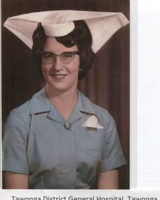
Photographs - Tawonga District General Hospital - Set of 21
In the early stages of the Kiewa Hydro-Electric Scheme the State Electricity Commission took over the financial and construction responsibility of the Tawonga District General Hospital building at a cost of 27,000 pounds. This included the removal and re-erection of the ex-military Bonegilla ward from Wodonga while in addition they carried out all the necessary building works that allowed the hospital to operate as a functional unit. The work was completed and handed over to the Hospital Committee of Management on September 1, 1949. Local residents raised 3,400 pounds through fund raising. The balance was met by the SEC and the Hospital and Charities Commission. The initial project was to provide for a basic temporary hospital which was later to include an Operating Theatre, Offices, Store, Mortuary and a Nurse’s Home, until the establishment of a permanent medical premises. Following the opening, 455 patients were admitted to the Tawonga District General Hospital and 254 operations were performed in the first year. The hospital relocated to Mount Beauty in the former SEC administration offices located in the town centre. Official opening of the 18 bed Tawonga District General Hospital on April 29 in 1961. Alpine Health CEO Mr Lyndon Seys oversaw the opening of the new Mount Beauty Hospital in November 2001 alongside Board of Management President Mr Andrew Randell, other board members and politicians. The Kiewa Hydro-Electric Scheme the State Electricity Commission played a pivotal part in the planning and initial funding of the Tawonga District General Hospital, with a view to providing medical support for its many workers on the Hydro scheme. Later, spouse and family members of workers were also able to access medical assistance The hospital was originally located in Tawonga away from the majority of the patients as the Hospital and Charities Board was not prepared to have it within the SEC controlled area. It was not until the gate at Tawonga South was taken down that the hospital was moved to the main centre of population at Mount Beauty. 1. Early nurses uniform; 2. Hospital Opening Ceremony; 3-7. Nursing Staff; 8. Delivery Room; 9. Mens Ward; 10.Enclosed Veranda; 11. Main Ward; 12-13. Kitchen; 14. Opening Ceremony 1949; 15.Original Hospital at Tawonga; 16-18. Relocated Hospital at Mt Beauty; 19. Rear of hospital and Matron’s quarters; 20. Hospital and Kiewa Valley House; 21. Renovated Hospital in 20001.Tawonga District General Hospital Tawonga; 2. Kiewa construction engineer Mr HHC Williams speaking at the opening of the hospital. Health Minister the Hon CP Gartside performed the official opening. L to R: TH Mitchell MLA; Manager of the hospital Mr RH Kronberg (obscured) Hon CP Gartside; CL McVilley; LT Knevitt; Matron AI Tarnish & W Sealey: 4. Dedicated Nursing Staff; 5. Nurse Campbell (nee Reid); 6. Sister Seager 1955 (nee Janice Burnett. First District Nurse; 7. L to R: Sister F Rosengrove; Sister J Griffiths; Matron AI Tarnish; Nurse D Satori; Nurse D Tregonning; Sister E Hill & Sister S O’Shannessy; 8. In the early years Tawonga District General Hospital had the second highest birth rate in Australia; 9. The men’s ward catered for men only in the early years of the hospitals operation; 10. The enclosed verandah at the original Tawonga District General Hospital allowed for an additional 10 beds; 11. Tawonga District General Hospital, Tawonga Main Ward. Ward ready and waiting for patients at Tawonga Hospital. Complete with lovely vases of flowers for every bed. Nice touch by the nurses; 12. Kitchen of Tawonga District General Hospital, Mt Beauty. The hospital kitchen provided meals for patients and a 3 course dinner for Meals on Wheels. In 1977, 11,795 meals were produced at an average cost of $2.60 per meal; 13. Tawonga District General Hospital, Tawonga. Kitchen. Kitchen staff employed in the old Tawonga District General Hospital 1949-1961; 14. The official opening ceremony of the Tawonga District General Hospital, 1949. The official ceremony was attended by a large number of residents and Tawonga District General Hospital was open for public inspection; 15. Original Tawonga District General Hospital transported form Bonegilla began operations in 1949; 16. In 1961, the Tawonga District General Hospital relocated to take a central position in the town of Mt Beauty in the former SEC Administration building; 19. The rear of the Tawonga District General Hospital and Matron’s house seen from Holland St, Mt Beauty during a snow storm in the mid 1960’s; 21. Tawonga District General Hospital & Kiewa Valley House, 2000. tawonga district hospital, mt beauty hospital, medical, health care, s.e.c. -
 Kiewa Valley Historical Society
Photographs - Demolition of the old Tawonga District General Hospital. Set of 8 colour photographs
In the early stages of the Kiewa Hydro-Electric Scheme the State Electricity Commission took over the financial and construction responsibility of the Tawonga District General Hospital building at a cost of 27,000 pounds. This included the removal and re-erection of the ex-military Bonegilla ward from Wodonga while in addition they carried out all the necessary building works that allowed the hospital to operate as a functional unit. The work was completed and handed over to the Hospital Committee of Management on September 1, 1949. Local residents raised 3,400 pounds through fund raising. The balance was met by the SEC and the Hospital and Charities Commission. The initial project was to provide for a basic temporary hospital which was later to include an Operating Theatre, Offices, Store, Mortuary and a Nurse’s Home, until the establishment of a permanent medical premises. Following the opening, 455 patients were admitted to the Tawonga District General Hospital and 254 operations were performed in the first year. The hospital relocated to Mount Beauty in the former SEC administration offices located in the town centre. Official opening of the 18 bed Tawonga District General Hospital on April 29 in 1961. The old weatherboard building was demolished around the late 1900’s to early 2000’s and replaced with a new modern brick building. Alpine Health CEO Mr Lyndon Seys oversaw the opening of the new Mount Beauty Hospital in November 2001 alongside Board of Management President Mr Andrew Randell, other board members and politicians. The Kiewa Hydro-Electric Scheme the State Electricity Commission played a pivotal part in the planning and initial funding of the Tawonga District General Hospital, with a view to providing medical support for its many workers on the Hydro scheme. Later, spouse and family members of workers were also able to access medical assistance The hospital was originally located in Tawonga away from the majority of the patients as the Hospital and Charities Board was not prepared to have it within the SEC controlled area and it was not until the gate at Tawonga South was taken down that the hospital was moved to the main centre of population at Mount Beauty.8 Colour photographs of the demolition of the original Tawonga and District Hospital situated in Mt Beauty circa 20001. No inscriptions 2. Side view of Tawonga District General Hospital, 1990’s 3. Demolition of the weatherboard hospital: Nurses station, ward and corridor 4. Demolition of the weatherboard hospital: kitchen & utility rooms 5. Demolition of the weatherboard hospital” front entrance & gardens 7. Demolition of the weatherboard hospital: Matrons House 8. No inscriptions tawonga & district general hospital; kiewa hydro electric scheme; mt beauty; -
 Kiewa Valley Historical Society
Photographs – Old Tawonga District General Hospital Mt Beauty. Set of 19 colour photographs
In the early stages of the Kiewa Hydro-Electric Scheme the State Electricity Commission took over the financial and construction responsibility of the Tawonga District General Hospital building at a cost of 27,000 pounds. This included the removal and re-erection of the ex-military Bonegilla ward from Wodonga while in addition they carried out all the necessary building works that allowed the hospital to operate as a functional unit. The work was completed and handed over to the Hospital Committee of Management on September 1, 1949. Local residents raised 3,400 pounds through fund raising. The balance was met by the SEC and the Hospital and Charities Commission. The initial project was to provide for a basic temporary hospital which was later to include an Operating Theatre, Offices, Store, Mortuary and a Nurse’s Home, until the establishment of a permanent medical premises. Following the opening, 455 patients were admitted to the Tawonga District General Hospital and 254 operations were performed in the first year. The hospital relocated to Mount Beauty in the former SEC administration offices located in the town centre. Official opening of the 18 bed Tawonga District General Hospital was on April 29 in 1961. The old weatherboard building was demolished around the late 1900’s to early 2000’s and replaced with a new modern brick building. Alpine Health CEO Mr Lyndon Seys oversaw the opening of the new Mount Beauty Hospital in November 2001 alongside Board of Management President Mr Andrew Randell, other board members and politicians. The Kiewa Hydro-Electric Scheme the State Electricity Commission played a pivotal part in the planning and initial funding of the Tawonga District General Hospital, with a view to providing medical support for its many workers on the Hydro scheme. Later, spouse and family members of workers were also able to access medical assistance The hospital was originally located in Tawonga away from the majority of the patients as the Hospital and Charities. Many SEC workers and their families have received medical care at Tawonga District General Hospital and Alpine Health over the years. A number of family members of SECV workers as well as other dedicated staff have provided high quality medical attention and support in all the facilities as nursing staff, support staff and volunteers. Many past staff members and their families still remain living in the Kiewa Valley area 19 Colour photographs of the Tawonga and District Hospital situated in Mt Beauty circa 2000. Including photographs of interior and of some staff members1. No markings 2. G Ryder at front entrance 3. Sister G Ryder in the Resuscitation Room 4. Nurse D Hateley in the Kitchen 5. Nurse D Hateley in the Casualty Room 6. Sister W McClelland in new nurse’s station 7. R Forrest, G Ryder, ?, M Ranton 8. Nurse D Hateley in the Pan Room 9. Tawonga District General Hospital: Resuscitation Room 10. Hospital Hallway 11. Empty Nurses Station 12. Tawonga District General Hospital: Nursery 13. Patient Tea Room 14, 15, 16, 17, & 18. No marking mt beauty district hospital, tawonga district hospital, bonegilla ward, ryder family -
 Kiewa Valley Historical Society
Photographs – Photographs of staff from Tawonga District General Hospital & Alpine Health – Set of 13 colour photographs
In the early stages of the Kiewa Hydro-Electric Scheme the State Electricity Commission took over the financial and construction responsibility of the Tawonga District General Hospital building at a cost of 27,000 pounds. This included the removal and re-erection of the ex-military Bonegilla ward from Wodonga while in addition they carried out all the necessary building works that allowed the hospital to operate as a functional unit. The work was completed and handed over to the Hospital Committee of Management on September 1, 1949. Local residents raised 3,400 pounds through fund raising. The balance was met by the SEC and the Hospital and Charities Commission. The initial project was to provide for a basic temporary hospital which was later to include an Operating Theatre, Offices, Store, Mortuary and a Nurse’s Home, until the establishment of a permanent medical premises. Following the opening, 455 patients were admitted to the Tawonga District General Hospital and 254 operations were performed in the first year. The hospital relocated to Mount Beauty in the former SEC administration offices located in the town centre. Official opening of the 18 bed Tawonga District General Hospital on April 29 in 1961. Kiewa Valley House nursing home was officially opened on March 6th, 1985, with a new lounge extension opening in May, 1993. Prior to this, residents had to travel to Beechworth, Wangaratta or Wodonga for care. The old weatherboard building was demolished around the late 1900’s to early 2000’s and replaced with a new modern brick building. Alpine Health CEO Mr Lyndon Seys oversaw the opening of the new Mount Beauty Hospital in November 2001 alongside Board of Management President Mr Andrew Randell, other board members and politicians.The Kiewa Hydro-Electric Scheme the State Electricity Commission played a pivotal part in the planning and initial funding of the Tawonga District General Hospital, with a view to providing medical support for its many workers on the Hydro scheme. Later, spouse and family members of workers were also able to access medical assistance. Many SEC workers and their families have received high medical care at Tawonga District General Hospital and Alpine Health and/or as residents of Kiewa Valley House over the years. A number of family members of SECV workers as well as other dedicated staff have provided high quality medical attention and support in all three facilities as nursing staff, support staff and volunteers. Many past staff members and their families still remain living in the Kiewa Valley area Set of 13 colour photographs of past nursing staff and support staff from Tawonga District General Hospital, Kiewa Valley House & Alpine Health 1. Marg Hickey, Barbara Clark & Margaret Ranton 2. Cheryl Clutterbuck & Rosemary Forrest 3. Margaret Ranton 4. Margaret Ranton holding unknown infant 5. Gwen Goss 6. Barbara Clark & Margaret Ranton 7. Margaret Ranton, Sue Zeinert & Jenny Piera 8. Margaret Ranton, Gloria Ryder & Jenny Piera 9. Sue Wesley, Ruth Barton, Margaret Ranton, Rosemary Forrest & Nola Henry 10. F Bogaski & H Sigmund 11. Maintenance Supervisor H Sigmund 12. Gardener Fred Keat & Handyman Joe Trezise (1977) 13. Nursing staff in new hospital 1-9 No markings 10 F Bogaski & H Sigmund 11. Maintenance Supervisor H Sigmund 12. Gardener Fred Keat & Handyman Joe Trezise (1977) 13. Nursing staff in new hospital tawonga district general hospital, kiewa valley house, alpine health -
 Kiewa Valley Historical Society
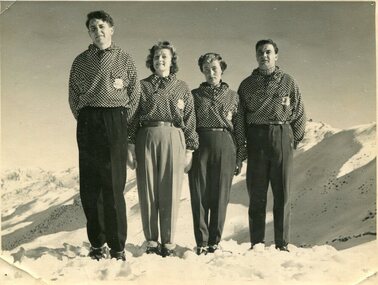
Photographs – Skippy St Elmo and other skiers – Set of 8 black and white photographs
Skippy and Toni St Elmo were responsible for early developments at the Falls Creek resort and for promoting a love of skiing. They left Melbourne in 1945 and settled at Falls Creek and moved into the first building constructed of corrugated iron and timber at Falls Creek in 1946. They were Falls Creek’s first workers with Toni employed by the State Electricity Commission to record weather-related data up to the construction of the Kiewa Hydro-Electric Scheme. In 1957, Toni was involved in building the first rope tow called Nissen on the same route as the Summit Quad. He also established the Nissen Ski School with ski instructor Milan Kovacic and was involved in the building of the resort’s first ski club Bogong in 1949. Toni taught Skippy to ski and she practised on the High Plains where she and her husband lived. Skippy St Elmo won many ski races during the 1950’s and represented Australia in New Zealand.Skippy and Toni St Elmo were pioneers of the Falls Creek area, promoting local ski sports and tourism. The played an important role in opening up the Falls Creek area and developing its sporting potential by establishing the first ski school, ski lifts and early lodge facilities. Skippy and Toni St Elmo were honoured at the Alpine Village at Falls Creek on November 17 2006, with the spreading of their ashes at the place which played such an important part in both their lives.Set of 8 black and white photographs of Skippy St Elmo and other skiers 1. Skippy and 3 others in New Zealand 1951 2. Skippy and 5 others Falls Creek 1955 3. Cake celebrating 20 years of sport at Nissen Lodge 4. Skippy and friend outside Nissen Lodge 5. Skippy on the ski slopes 6. Skippy on the ski slopes 7. Albury Ski Club team New Zwealand 1957 8. The Bogong Ski Club 1950 Written on back of photos 1. Bob Howe Albury, Skippy New Zealand 1951 – 942H 2. Falls Creek 1955. Skippy St Elmo: H Devonassore; Margaret ?; ?; Tony St Elmo; Olive? 3. Written on cake Nissen Alpine Club. 20 years of sport. FRED 4. Skippy St Elmo 5. Skippy 6. Skippy 7. Bob Howe (Albury) Skippy New Zealand 1957. Albury Ski Club Team raced in NZ 8. The Bogong Ski club, Coronet Park, 1950. M Denham (Capt); B Wiltshire; R Roberts; Skippy St Elmo; Gwen Morris; J Frazer; J Smith; L Piera; Manager & Coach Toni St Elmo. J D Knowles Photographer Box 188, Queenstown. 744B falls creek, skiing, bogong high plains -
 Kiewa Valley Historical Society
Photographs –Collection of 10 copies and original black and white photographs and printed articles relating to skiing on the Bogong High Plains
After World War II, the Kiewa Hydro-Electric Scheme was started in the Kiewa River Valley by the State Electricity Commission of Victoria. On land previously used only for summer cattle grazing in the natural alpine grasslands, the first ski lodge was built in 1948 by workers from the hydro scheme as skiing was a popular recreation. Many of the hydro employees were of European background and had grown up enjoying skiing and snow sports in their homelands and were keen to continue to pursue their winter sports interests. The first lift, a rope tow, was built in 1951 at Falls Creek and the first chairlift in Australia was constructed there in 1957. Two T-Bars were opened in 1961. In 1964, the Victorian Municipal Directory recorded that Falls Creek had 29 ski club lodges and 16 commercial lodges. The area became a popular tourist destination for both winter and summer sports.: Employees of the State Electricity Commission of Victoria in the Kiewa River Valley were the earliest skiers on the Bogong High Plains and built one of the first ski lodges at Falls Creek. They were amongst those pivotal in the development of the skiing and tourist industry at Falls Creek and on the Bogong High Plains. Collection of 10 copies and original black and white photographs and printed articles relating to skiing on the Bogong High Plains. Some pieces have been enlarged to A3 poster size copies for display purposes 1. Copy of black and white photograph of group of skiers at Falls Creek 2. Copy of photograph of early skier on Bogong High Plains with temporary buildings and tents in the background 3. Copy of photograph of 3 skiers on Mt McKay 4. Copy of SECV photograph of Rocky Valley Camp under snow 5. Early sepia photograph of Falls Creek village with skiers in the foreground 6. Copy of a page from booklet (SECV?) promoting the benefits of owning a holiday home in the Bogong Village area 7. Copy of a page from booklet (SECV?) promoting the benefits of holidaying in and around Falls Creek/Mt Beauty 8. Panoramic view of ski fields with skis in the foreground 9. Photograph of young skier (identity unknown) 10. Photograph of 2 male skiers (identity unknown) performing a small jump 1. Bogong Ski Club Members & Friends 1944 2. Jack Neve – electrician. Rocky Valley 3. 17.5.55 Skiers ascending Mt McKay 4. State Electricity Commission of Victoria. Date:17.8.55 No:K8132 Kiewa Hydro Electric Works. Rocky Valley Camp – From Engineering Office 5 & 9 No markings 6 & 7 Short article relating to photos on each page 8. Handwritten signature on rear of photo (Sandra Conea) 10 Faded unreadable photographers stamp and handwritten numbers 6875 on rear secv; bogong high plains; skiers; falls creek; tourism -
 Kiewa Valley Historical Society
Photographs and copies of photographs of the pack horses and early horsemen who transported supplies to outposts in the Bogong High Plains, via cattle tracks before access roads were made
In the mid to late 1930’s survey outposts were established to plot the early stages of the Kiewa Hydro Electric System for the SECV in the Bogong High Plains. Before any roads were built, the old cattleman’s tracks were used with packhorses to deliver supplies, wages and mail and collect timesheets and correspondence from the workmen and dam builders living in canvas tents and at the outlying survey posts. The trip up the mountain was long and hard and dangerous for both horse and man Most of the men of the survey teams were not bush-men and were often ill equipped for the harsh weather and living conditions of bush camping, often arriving in their city clothes ready for work. The tent city at Bogong was destroyed by bush fires in 1939 after which an access road was built from Mt Beauty to transport building materials for more permanent dwellings for workmen. Pack horses continued to be used for transporting goods etc. to workers further up the mountain.Without the work of horsemen and their pack horses providing supplies and communications for outlying outposts, surveying and early planning for the Kiewa Valley Hydro Electric scheme could not have gone ahead and the dams and power stations which support the system could not have been constructed. The Hydro-electric scheme, and the workers who planned and built it play a major part in the early history of the Kiewa Valley and many original families still remain living, or have ties with the local area.: Set of 21 black and white photographs and copies of photographs depicting the pack horses and the men who handled them, transporting supplies and correspondence to the outlying camps and survey posts in the Bogong High Plains, via the rough cattlemen’s tracks. Photographs also show the early tent camps of the workers. Some photos mounted on A4 white paper. Some photos enlarged to A3 poster size for display1. Handwritten on back – Max Lawrence 2. -8 No inscriptions 9. Handwritten on back- Packing in supplies for early workers of the Kiewa Hydro scheme. There were no roads in the early days of the scheme 10. Printed on bottom of photo- Roper’s cattle on road below Howman’s Gap 11. Handwritten on back – Roper’s et al about to leave for the high plains 12. Printed under photo- Syd Ryder at the Pretty Valley Cut-Out (JBR) 13-16. No markings 17. Printed under photo- Gwen Talbot visits the Camp area. 1937 18. Handwritten on back- 14/1 Barbara Talbot 19. No markings 20-21. No markings 22. Printed under photo- STATE ELECTRICITY COMMISSION OF VICTORIA. Date: 15-3-45 Time: 8.0pm No: K 1838 Kiewa Hydro-Electric Works, Investigations 1944-1945 – Survey Camp at Young’s Hut pack horses; bogong high plains; survey posts; supplies delivery -
 Kiewa Valley Historical Society
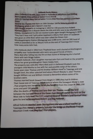
Posters – Set of 3 A4 posters depicting the early days and people in the Kiewa Valley
In the 1830’s, European pastoralists started moving south from NSW into the Alps. In 1836, cattle grazing began around Omeo and the runs spread out into the foothills. The higher country was used for summer grazing and huts were built for shelter and storage during stock mustering. The lure of gold brought many people to the Alps from around 1850 to 1900. Bushfires destroyed the forests around Melbourne in 1939 and the boom in house-building after World War II ked to increased demand for timber from the Alps. This resulted in the building of a network of roads which helped open up access to the Alps. The early 1940’s brought the first of many workers to the Alps for the planning and construction of the Hydro-Electric Scheme. These were the pioneers and early settlers of the Kiewa Valley and provided a wealth of characters and a tapestry of stories and adventures to be handed down to future generations.These 3 posters, which were most likely produced for promotional purposes provide a glimpse into the early lives of the pioneer families of the Kiewa Valley through pictures and verse. They show their lifestyle and outline the hardships they had to endure in living and working in the Alpine region. They also highlight the early arguments regarding grazing in the high country which would ultimately lead to the end of the long traditions of the high country cattle men. Set of 3 A4 size posters with black and white photographs and text and colour background depicting various parts of the history of the Kiewa Valley. 1. Titled - ‘Life wasn’t meant to be easy’ Describes early life for Kiewa Hydro workers. 2. Titled - ‘Cattlemen of the High Plains’ Describes a brief history of life of the cattlemen of the high plains 3. Titled – ‘There are Places I’ll remember’ Depicts early photographs of residents of the Kiewa Valley, also includes the words from a John Lennon song as per poster title. Printed on each poster – Poster designed by Dyanne Photography - Wodonga 1. Printed at bottom of poster – Sources: G Napier and G Easdown “The Kiewa Story” 1993. Southern Hydro Archives, N Hetherington and R Hollands. G Gardner “The Kiewa Kids” 1998. 2. Printed at bottom of poster – Sources: D Purland. Handwritten at top of poster- Poster 4 3. Printed at bottom of poster – Sources: B Roper, W Davies, D Higginson, H Ryder. Handwritten at top of poster- Poster 3 kiewa valley; tourism; lifestyles -
 Kiewa Valley Historical Society
Set of 2 hand coloured photographs of early Mount Beauty, photographs of Mount Beauty, 1947/48
Construction of the town of Mount Beauty commenced in 1946 and continued until 1952. It was built to provide family accommodation for workers engaged in the construction of the hydro electric power scheme. As well as housing, there was an administration building, staff hostel, merchandising centre, workmen's camps, base stores and workshops and the Mount Beauty Terminal Station. The first house was occupied in November, 1946 by the then manager of the trading store, with a frontage onto Hollonds Street. The total number of houses erected was 488, 162 custom built and 326 prefabricated. The main workmen's camp can be seen just left of the centre of the photograph and accommodated 144 men at the time of the photograph. By 1950 it could accommodate 1200men. Photo No. 1 is taken in 1947/early 1948 as there is no evidence of the staff hostel under construction. This hostel was commenced in August/September 1948 and is clearly shown in photograph No. 2, dating this photo as 1948 as it is before the completion of the bypass road connecting to the main (high plains) road. This road was constructed in 1939 and in 1948 followed the route of Tawonga Crescent. This remained in use until the bypass construction was completed in early 1949 and does not appear to be finished in this photograph.. Both photographs are taken from the power line easement adjacent to the Bright road.Significant historical pictorial record of the development of a town from grazing land. The type of terrain that had to be surveyed and then to construct roads and other infrastructure, with very little machinery, is also of prime significance in the development of the Kiewa Hydro Electric Scheme.Two photographs, both hand painted to show colours, and both of Mount Beauty c 1947/48 not long after commencement of construction of homes and facilities for workers.Photo No.1 - on back of photo, left upper corner, faintly in pencil, SPIKE, underneath this is written T Pay,. Photo No. 2 - on back of photo, left upper corner, faintly in pencil, Jmount beauty, housing, accommodation -
 Kiewa Valley Historical Society
Papers - Hollonds' Family and their memories, 2013
... ' Boarding house, SEC Depot at Tawonga, building of Bogong Township... at Tawonga, building of Bogong Township, Early Scenes on the Kiewa ...The Hollonds' family were original settlers in the Kiewa Valley at Mulagong. Their descendants owned land in Tawonga, Tawonga South and between the East and West of the Kiewa river. Hollonds had a cattle run on Mt Fainter which was later given to the Hicks family.Members of the Hollonds family lived, worked and married in the Kiewa Valley. These papers describe the connection to the families and the Kiewa Valley.Typed papers donated by the Hollonds' family covering: The Hollonds Family History, Cattlemen, 'Snowy' Miller, Mrs Hollonds' Boarding house, SEC Depot at Tawonga, building of Bogong Township, Early Scenes on the Kiewa Scheme.hollonds family, tawonga station, cattlemen, mt beauty land, tawonga boarding house -
 Kiewa Valley Historical Society
Four photographs of the Blue Duck Hotel and two Photos of the Glen Wills area, c1920 Post cards, c1949/50 small photographs
The Blue Duck Hotel stands at the confluence of 3 trout rivers - Cobungra, Bundarra and Mitta Mitta, called Angler's Rest. The original 1900's building was of slab construction and operated as a butcher shop, servicing miners on the track from Omeo to Mt. Wills. In 1912 it was purchased by a miner, Billy O'Connell, and he obtained a hotel license. In the early 1920's he transported 2 houses from Omeo on Horse drays. One is the main building of the Blue Duck and the other was a residence where Billy and his wife raised their nine children. The small log structure behind the pub is State School No.4286 where the children attended school. A teacher was shared with Glen Wills. By the late 1920's the hotel was discovered and patronized by keen anglers. Sir Harold Clapp (head of the railways) was one and he had the bronze blue duck cast and presented to the owners in the 1930's. This stands at the entrance to the premises.These photographs are of a building, in a remote area, that has provided a service to miners, anglers and travellers for over 100 years and continues to do so today. It also played a vital role in the history of the Mt. Wills/Omeo gold mining days.3 Post cards, Black and White photographs. 3 small black and white photographsPost Card No. 1 - "Blue Duck Hotel- Omeo-Glen wills road Ray Love Series No.2"(written on lower front) Post Card No. 2- "Looking towards Bogong High Plains. Omeo-Glen Wills road"(front, bottom, L hand) Ray Love Series No. 18 (front, lower R hand corner) On both of above photos, centre back, is stamped POST CARD and underneath this is printed "A GENUINE PHOTOGRAPH'/ Post Card No. 3 - Bottom L hand corner "Mystic Sea Australian Alps". R hand corner "(Bulmer Copyright)". Each small photograph, handwritten on back "Blue duck Hotel". All have circular stamp with "Print by Wilson White Albury" blue duck hotel; anglers rest; omeo highway; fishing; mining -
 Kiewa Valley Historical Society
5 small black and white photos of Clover Dam and Power Station, c1948
The construction of Clover Power Station was commenced in October 1942 and the power station building was completed in May, 1943. The first machine was placed in service August, 1944 and the second machine in May, 1945. The water discharges directly into Clover Dam and re-used in West Kiewa Station. Clover Dam - stripping of foundation area commenced in January 1948 but the final concrete pour was not until 14th August, 1954.Pictorial history of the early construction undertaken in the building of the Kiewa Hydro Electric Scheme. Clover power station (No. 3 Development) was the first power station to be built .5 small black and white photographsPhoto No. 1 - handwritten in ink on back ' No. 3 Power Station Clover Flat Nov. 1948 Photo No. 2 - handwritten in ink on back 'No. 3 Power Station Clover Flat Nov. 1948 Photo No. 3- handwritten in ink 'Clover Flat looking towards work area of Clover Dam. Taken near #3 PS. Nov. 1948 Photo No 4 - Handwritten in ink 'Preparation for wall of Clover Dam Dec. 1948 Photo No.5 - handwritten in ink 'Preparation for wall o f Clover Dam Dec. 1948. Photo Nos. 1,2 3, on the back have circular stamp with 'Print by Willson White Albury'. In pencil is the number '78'. Photo Nos. 4, 5, have written on the back in pencil, number '14'. construction, clover power station, clover dam, -
 Kiewa Valley Historical Society
Photographs – Set of 13 colour photographs of spectators preparing for the street parade to celebrate the first Official Hoppet race run at Falls Creek in 1991, 1991
In 1977 a group of Mount Beauty cross country skiers formed the Birkebeiner Nordic Ski Club. In 1979, a version of the famous Birkebeiner race, the first Australian Birkebeiner was held at Falls Creek. In June 1990 representatives from Australia put their case for a southern hemisphere race in the series. Following a trial event in 1990. Australia became the 12th member of Worldloppet in the winter of 1991, with the first Kangaroo Hoppet. In 1991 a parade and commemorative torch lighting ceremony were organised in Mt Beauty as part of the celebrations to mark the first official Kangaroo Hoppett with participation from local community groups and commercial organisations, the Chamber of Commerce, local government representatives and individuals.Kangaroo Hoppet caters to diverse interests by offering a 42km and 21km event. It also offers a 7km event that attracts skiers, ranging from elite juniors to parents, grandparents, babies and first time skiers. It is recognised on the world cross country ski race calendar. It brings large numbers of participants and spectators to the area which support tourism, local businesses and employment. The 2018 event will be the 28th Kangaroo Hoppet, with cross country skiers travelling from across the country and overseas to compete.Set of 13 colour photographs of spectators lining both sides of Holland St in preparation for the Kangaroo Hoppet street parade. Photographs show the original hospital buildings and street-scape of the early 1990’sNo markingskangaroo hoppet; cross country skiing; ski race; bogong high plains, mt beauty, parade -
 Kiewa Valley Historical Society
Photograph - Folder of Photographs – Photocopied set of black and white photographs (pages 9 - 18) from the display folder put together by KVHS to document life on the Kiewa Valley Hydro-electric Scheme
Although the Kiewa Hydro-Electric Scheme was first proposed in 1911, construction did not commence until 1938. As part of the push to cut electricity costs and diversify supply, the Victorian Government (circa 1930) initiated the conversion from primarily brown coal supply to hydro – electricity. Field investigations during the 1940’s resulted in a new proposal for a scheme that had more than double the capacity of the 1938 scheme. The Kiewa Hydroelectric Scheme became the largest scheme of its kind in the State Of Victoria and the second largest scheme in Australia. The number of personnel involved in the planning and construction of the scheme increased dramatically. During the late 1940’s, most activity centred around the construction of the West Kiewa Power Station, Rocky Valley Reservoir, McKay Creek Power Station and the Bogong Creek Aqueduct.A common thread across all the larger hydro scheme constructions was the need for workers, both qualified and unqualified who came from around the world seeking a new life for themselves and their families. New accommodation and facilities were required for the army of workers engaged in construction in often remote and wild areas. The SEC had a high demand for timber, and set up the first of a number of sawmills at Bogong Creek in 1939 and set up the first hardwood logging in the headwaters of the Kiewa River. These new ‘towns’ such as Mt Beauty and Bogong, survived, serving the needs of operational personnel and their families, and expanding with growth of new industries. Mount Beauty, and to a lesser extent Bogong, are among these places. PHYSICAL: Large A3 size spiral bound display folder containing 21 pages of photocopied black and white photographs of various aspects of the early days of the Kiewa Valley Hydro-electric scheme including equipment, various work sites and photographs of workers and their families. 1-Bridge across Tailrace Channel 1946 2-New Mess building, Mt Beauty 3-Homan’s Gap Saw Mill 4- Diamond Drilling Plant – Big Hill 5-Rocky Valley Camp-Mess Building 6-Parlimentary Party at Rocky Valley 7-No.4 Headrace Tunnel 8- Allis-Chalmers Tractor School 9- SECV Heavy Machinery lined up by road 10- No. 5 Raceline – Balasting Track with improvised truck 1-1946 – Bridge across tailrace channel Page number 9 2-New mess building, Mt Beauty 6.4.46 Page number 10 3- STATE ELECTRICITY COMMISSION OF VICTORIA Date: 10.1.47 Time: 11.40am No K2271 Kiewa Hydro Electric Works Homan’s Gap Saw Mill – Rip Saw Page number 11 4- STATE ELECTRICITY COMMISSION OF VICTORIA Date: 5.10.47 Time: 11am No K4111 Kiewa Hydro Electric Works Diamond Drilling Plant – Big Hill Page number 12 5- STATE ELECTRICITY COMMISSION OF VICTORIA Date: 11.2.48 Time: 3pm No K4277 Kiewa Hydro Electric Works Rocky Valley Camp-Mess Building Page number 13 6- STATE ELECTRICITY COMMISSION OF VICTORIA Date: 15.4.48 Time: 4.30pm No K4397 Kiewa Hydro Electric Works Parlimentary Party at Rocky Valley Page number 14 7- STATE ELECTRICITY COMMISSION OF VICTORIA Date: 22.8.48 Time: 9am No K4668 Kiewa Hydro Electric Works General view of No.4 Headrace Tunnel Page number 15 8-STATE ELECTRICITY COMMISSION OF VICTORIA Date: 5.9.49 Time: 10am No K5180 Kiewa Hydro Electric Works Allis-Chalmers Tractor School – HD 19, Mr I Crossthwaite at Controls Page number 16 9- No markings Page number 17 10- STATE ELECTRICITY COMMISSION OF VICTORIA Date: 7,12.49 Time: 4pm No K5423 Kiewa Hydro Electric Works No. 5 Raceline – Balasting Track with improvised truck. Page number 18 secv; kiewa hydro electric scheme; mt beauty; bogong; construction area -
 Kiewa Valley Historical Society
Photograph - Folder of Photographs – Photocopied set of 10 black and white photographs (pages 19 - 28) from the display folder put together by KVHS to document life on the Kiewa Valley Hydro-electric Scheme
Although the Kiewa Hydro-Electric Scheme was first proposed in 1911, construction did not commence until 1938. As part of the push to cut electricity costs and diversify supply, the Victorian Government (circa 1930) initiated the conversion from primarily brown coal supply to hydro – electricity. Field investigations during the 1940’s resulted in a new proposal for a scheme that had more than double the capacity of the 1938 scheme. The Kiewa Hydroelectric Scheme became the largest scheme of its kind in the State Of Victoria and the second largest scheme in Australia. The number of personnel involved in the planning and construction of the scheme increased dramatically. During the late 1940’s, most activity centred around the construction of the West Kiewa Power Station, Rocky Valley Reservoir, McKay Creek Power Station and the Bogong Creek Aqueduct.A common thread across all the larger hydro scheme constructions was the need for workers, both qualified and unqualified who came from around the world seeking a new life for themselves and their families. New accommodation and facilities were required for the army of workers engaged in construction in often remote and wild areas. The SEC had a high demand for timber, and set up the first of a number of sawmills at Bogong Creek in 1939 and set up the first hardwood logging in the headwaters of the Kiewa River. These new ‘towns’ such as Mt Beauty and Bogong, survived, serving the needs of operational personnel and their families, and expanding with growth of new industries. Mount Beauty, and to a lesser extent Bogong, are among these places. Large A3 size spiral bound display folder containing 21 pages of photocopied black and white photographs of various aspects of the early days of the Kiewa Valley Hydro-electric scheme including equipment, various work sites and photographs of workers and their families. 1-Allis Chalmers Tractor School 2- Gardens outside Administrative Office – Mt Beauty 3- Mt Beauty house – 1950 4-Bridge over Pretty Valley River, Bogong 5-Rocky Valley Spillway Tunnel break through 6-Ni 1 Headrace Tunnel drilling face 7-No 4 Power Station Drilling 8-Clover Dam Flood Waters 9-No1 Head Race Tunnel Portal Building 10-Clover Dam 1-STATE ELECTRICITY COMMISSION OF VICTORIA Date: 5.9.49 Time: 10amm No K5174 Kiewa Hydro Electric Works Allis Chalmers Tractor School Page number 19 2-STATE ELECTRICITY COMMISSION OF VICTORIA Date: 22.2.50 Time: 3.30pm No K5601 Kiewa Hydro Electric Works Gardens outside Administrative Office – Mt Beauty Page number 20 3-Mt Beauty house – 1950 Page number 21 4-STATE ELECTRICITY COMMISSION OF VICTORIA Date: 23.10.50 Time: 11.15am No K6331 Kiewa Hydro Electric Works Bogong-Bridge over Pretty Valley River Page number 22 5-STATE ELECTRICITY COMMISSION OF VICTORIA Date: 23.6.50 Time: 2.30pm No K5844 Kiewa Hydro Electric Works ROCKY VALLEY SPILLWAY TUNNEL BREAK THROUGH Page number 23 6-20/3/52 – No. 1 Headrace Tunnel Drilling face (E.E.E. contract) Page number 24 7-6/6/52 – No 4 Power Station – Drilling Page number 25 8-STATE ELECTRICITY COMMISSION OF VICTORIA Date: 6/6/52 Time: No K7113 Kiewa Hydro Electric Works Clover Dam Flood Waters Page number 26 9-STATE ELECTRICITY COMMISSION OF VICTORIA Date: Oct 1952 Time: No K7239 Kiewa Hydro Electric Works No. 1 HEAD RACE TUNNEL PORTAL BUILDING. Handwritten underneath – This information from Ron White-the later Principal Hydro Engineer of the SEC. Oct 1952 Location incorrect? All work on No 1 had ceased after financial crash of 1951. This photo would refer to No 4 Headrace Tunnel? Page number 27 10-STATE ELECTRICITY COMMISSION OF VICTORIA Date: Jan 1953 Time: No K7307 Kiewa Hydro Electric Works CLOVER DAM Page number 28 secv; kiewa hydro electric scheme; bogong; mt beauty; construction area -
 Kiewa Valley Historical Society
Photographs – Set of 4 black and white photographs. One of a wooden church and three of rural homes and farmland. Area not identified
Europeans arrived in the Kiewa and Ovens Valleys in the 1830's and 40's. Following the drought of 1838-44, seeking out the rich pastures in the fertile Valleys. It proved to be perfect conditions for dairy farming and the raising of cattle. Miners Cottages and other similar wooden structures were a common sight in the area as they were a modest form of accommodation for their period, were quick to erect and economical as they made use of locally available building materials such as local timbers.These photographs provide a snapshot into the early dwellings and architecture of the Kiewa and Ovens Valley regions, including buildings such as the church, which provided an important gathering place for social interaction, especially in these isolated areas.1-Wooden church building with no identification. Large tree in the foreground in front of church 2&3- Black and white photographs of farmland and assorted dwellings, mostly miners style cottages in a valley with mountains in the background. A bridge with wooden railings is visible over the river in the middle of the photograph, also a more modern dwelling is visible in the north east of the photograph close to the river. 4-Black and white photograph of residential homes and farmland with an unsealed road running through the middle. Foreground shows a field which has been semi cleared of trees (stumps remaining). In the background are larger farming properties with the road disappearing into the distant hills. This might be Old Tallangatta before the town was moved in 1956. 1-3 - No inscriptions 4- Signature written on back in lead pencil - Sandra Templebuildings; church; farmland -
 Kiewa Valley Historical Society
Photograph – Set of 3 black and white photographs of Bogong Village circa late 1930's - 1940's during early construction of Lake Guy ( in the foreground), Late 1930's - 1940's
In 1940 Field Headquarters for the Kiewa Scheme were established at Bogong with office, workshop facilities and accommodation for workmen, staff and some families constructed. (There had been a 'tent camp' on this site in 1939 but was destroyed by bush fires) Construction of accommodation continued until 1947. A total of 40 houses plus a hostel for single staff, post office, police station, medical centre and primary school all with water and sewerage and electricity supply. The staff hostel was known as Kiewa House and is now occupied by the Education Department. Lake Guy was named after Mr. L.T. Guy who was the Resident Engineer in charge of construction work and associated activities on the Kiewa area. He held this position from 1939 to November 1946 when he was transferred to Head Office. The Bogong Township was developed firstly as an accommodation centre (base camp) for construction workers employed under the Kiewa Hydroelectric Scheme. Due to the influx of European workers into the Township the beautification of the immediate surrounds (gardens etc.) had a distinct European flavour. This environment has been very beneficial for tourism in later years. At the completion of the scheme, in the 1960's, the village was opened to public/tourism use. Strict environmental control has not allowed for any extensive redevelopment in tourist accommodation and basically restricted it to the accommodation initially built for the construction workers. Activities such a bike riding, snow skiing, restricted horse riding and bush walking on the Alpine plains and mountains are now a viable part of the Kiewa Valley Tourist Industry. The lake is one of the many water storage reservoirs used to supply the power stations their main power to run the huge turbines generating the final product, electricity3 black and white photographs of the Bogong camp area showing the clearing of trees for the construction of the Junction Dam and Lake Guy. Some administration buildings have been constructed, but part of the tent camp can be seen to the right of the photograph in front of the buildings. bogong village; junction dam; lake guy; kiewa hydro electric scheme; secv -
 Kiewa Valley Historical Society
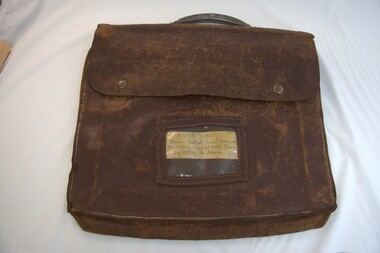
Mail Bag
This bag was used by the Timekeeper at Pretty Valley camp to carry timesheets to the administration building at Bogong and later at Mt Beauty. In the early days this bag was collected by the Timekeeper who rode a horse to the camps fortnightly.SECV - Kiewa Hydro Electric SchemeBrown leather mail bag with stitched gusset. Metal and leather handle fastened at the top by two metal rings attached to a leather covered rod. A flap at the front fastened by two metal press studs. Front pocket of leather and transparent material stitched on. Internal leather strap fastened by metal press stud in the centre. "SEC MAIL" stamped on the front flap and back of bag. Written inside in ink "BAG NO.11 TIMEKEEPER - PRETTY VALLEY". secv, khes, mail bag, timekeeper, pretty valley, payroll -
 Kiewa Valley Historical Society
Photographs - Townships of Mt Beauty and Bogong and the Kiewa Valley, c 1940, 1950, 1960
The township of Mt. Beauty was built to provide family accommodation for personnel working on the construction of the Kiewa Scheme. construction commenced in 1946. Photo 1 is looking towards the corner of Lakeside Ave. and Kiewa Crescent. The Post Office is on the corner and the original building housing the Co op store was in Kiewa Crescent. Photo 2 is taken at a later date as the garden in front of the Post Office is well established. The Community Centre is centre left of the photo and the back buildings are the staff accommodation called "The Chalet". Photo 3. Farming country taken from Wallacedale. The Wallaces were one of he early farming families in the Kiewa Valley. Photo 4. This photo is of Junction Camp at Bogong Village and was commenced late in 1939 and by 1940 accommodated 96 men who were engaged in work on Junction Dam. Sleeping accommodation was provided in hutments, each of four rooms, each room being approx. 12 feet by 10 feet and provided for the accommodation of 2 men. This camp remained in use until November 1962.These photos have both historical and social significance. They show the type of accommodation available for workers during the construction of the SEC Kiewa Hydro Scheme as well as early streetscape views of Mt. Beauty. The Junction Camp photo also shows the state of the forest following the 1939 fires in the area.4 Black and white photographs of various sizes.Photo 1. On back, hand written in pencil: top left hand corner: "Sept 1950". Centre of photo: "Return to Gibson Envelope". Right hand side: "Cooper". Bottom left corner: "Mt. Beauty Camp SEC Kiewa Scheme". Photo 2. No inscriptions or markings. Photo 3. Back of photo handwritten in pencil: "In W>T> June 14. 1961 page31. Some of the farming country in the Kiewa Valley. This taken from the home of Mr. Geoff Wallace Wallacedale, Kergunyah where some of his 600 cattle were rounded up." Bottom right corner "Return to Gibson Envelope". There is a copyright stamp belonging to "the Herald & Weekly Times Ltd. also on the back. Photo 4. Typed on a sticker on the back of the photo "Stable attendants Cottage and Camp Sept. 1940".camp, sec kiewa scheme, kiewa, cattle, mt. beauty -
 Kiewa Valley Historical Society
Photograph - 30 black and white photographs (assorted sizes) plus page from a newspaper and copied article on A4 paper, c1880's c1910 - 1920 (photographs) Newspaper 1961
K2,3 and4 are of the Kiewa River and two of the bridges spanning the river along the valley. K3 and K4 would have been taken in the 1880's and show the type of trees and plant growth along the river prior to land clearing for farming. K5 is of the Running Creek Cricket Team and therefore there was sufficient population in the area to form and maintain a team as well as have other teams in the relatively near vicinity to provide competition. Note the horse drawn cart which provided transport. Date taken is unknown but possibly c 1910. The Mt. Buffalo Chalet was built in 1910 by the Victorian Government. It was Australia's first ski resort and has served generations of skiiers, hikers and families over the years. It was built for 3195 pounds and has had stories and wings added since and is the largest timber building in Australia. B4 is the earliest photo in this group as the garden is in early stages of development - the other photos show the growth of the shrubs and would be taken about c 1920. Note the cars and motor bikes. It closed in 2006. The other photos are of general interest only but interesting to see that there were donkey's grazing. There is no information as to their purpose on Mt. Buffalo. Four different Kiewa Valley families are represented in the photographs. Their descendants still live in the Valley and carry on the traditions of beef and dairy farming. Of particular interest is the photo of Miss Marjorie Clemence, the first School Teacher of Upper Gundowring School. Gundowring pastoral run was taken up in 1838 and occupied by framers in the 1860's. The area was known as Gundowring and Upper Gundowring. The Gundowring School was opened in 1871 and most likely the Upper Gundowring school would be built at the same time. It was School No. 2733 and situated in Boyd Road. It closed in 1953 when the Kiewa Consolidated School opened. The newspaper page describes the activities in which the local community of Kergunyah were in engaged in that period - Red Cross, Fire Brigade, cattle round up and some of the identities involved. The article photocopied from the Yackandandah times states that he (Norman Coad) "was sent to the Ovens District Hospital, Beechworth for treatment" which would mean that this was the closest hospital to the Kiewa Valley for emergencies in 1912.The Kiewa Valley photographs are of social significance showing two of the early bridges allowing the community easy access to both sides of the river and also the tree and plant growth before land clearing for farming. The photos of Mt. Buffalo Chalet have social, architectural and historical significance. the Chalet has been used by skiers, bush walkers and day trippers since its completion in 1910 and its closure in 2006. It is listed in the Victorian Heritage Register. The family photographs are of social and historical significance as they are of early farming families in the Kiewa Valley and also depict the dress, of both men and women) in the late 1880's. The write up in the Weekly Times has social significance as it depicts the social and farming activities and photos of the local residents from around that area. The article from the Yackandandah Times is of a personal nature with concern for the individual involved. Note: There is a photo of the gentleman mentioned in the article (Mr. Norman Coad) in the Families of the Kiewa Valley (F4) as above.30 black and white photographs - 5 of the Kiewa Valley, 8 of families of the Kiewa Vallley and 17 of Mt. Buffalo. Various sized photos. Page from the Weekly times and copied article from the Yackandandah Times on A4 sheet.(Note for easier identification they have been numbered and grouped - K1-5 (Kiewa Valley), F1-8 (Families) and B1-17 (Mt. Buffalo). K1: handwritten in ink, lower L hand corner "Bogong in the distance". K2: handwritten in ink lower L hand corner "Mongan's Bridge or Towonga". K3 handwritten in ink "Taken from Mongan Bridge looking up stream". K4 - no inscription. K5: handwritten in ink, back of photo "Running Creek Cricket Team". F1: handwritten in ink on back "Mrs. Heap" and lower down in pencil "1880's". F2 handwritten in pencil at top of back phot "Land at Tawonga TROVE The Y'dah Times 20/2/1913" and lower down in ink "Henry Ellis Larkin". F3: handwritten in ink bottom edge "Mrs Coad". Note that this photo is a postcard. F4: Written in ink lower edge "Norman Coad". Note this photo is also a postcard. F5: Lower left corner in Ink "Harry Larkin". F6: lower half back of photo, in ink "Bernie Maddison". F7: on back of photograph in ink "Miss Marjorie Clemence first School Teacher Upper Gundowring: and underneath, in pencil "C1880's". F8: Handwritten in ink on back of photo "Frank & Mrs. Keat & Lesley of Tawonga". Lower down in pencil "c1912-1914". B1: Back of photo in ink "The Chalet Mt. Buffalo". B2: no inscription. B3: "chalet at Bufflo" in ink lower left corner. B4: This is a post card. Written in ink is "Mt. Buffalo Chalet". B5 - B10 printed in ink, lower left corner "Buffalo". B11: no inscription. B12: "Mt. Buffalo" lower R corner. B13: "Buffalo?". B15: Printed in ink lower edge "Picnic at Buffalo". B16: "Donkeys on Mt. Buffalo" printed in ink lower edge. B17: handwritten in ink across back of photo "Donkeys & top of Mt. Buffalo with the Monileith in the distance". A4 sheet of paper describing an accident to Mr. Norman Coad. Under article is : Yackandandah Times (Vic: 1890 - 1931), Thursday 18 July 1912, page 3. A page torn from the Weekly Times, June 14, 1961 and entitled "Kergunyah has picturesque setting". kiewa valley, farming, families, kergunyah, gundowring upper, mt. buffalo chalet, briggs family, larki family, coad family, clemence family, laskowski collection -
 Kiewa Valley Historical Society
Folder - Early Photos of Mt Beauty
Mt Beauty township was built during the 1950's to house the employees of the State Electricity Commission working on the Kiewa Hydro Electric Scheme. After the completion of the Kiewa Hydro Electric Scheme many houses were sold and the public buildings handed over to the Alpine Shire. Mt Beauty has always been a tourist destination especially with its proximity to the ski fields at Falls Creek.This folder contains many early photos of Mt Beauty showing the construction town during its development during the Kiewa Hydro Electric Scheme and its early days of tourism. A3 size black plastic folder with clear plastic sleeves holding early black & white photos of Mt Beauty township. Also included are: 1. 3 foolscap pages -Nov., 1953 Kiewa Hydro-Electric Scheme Progress. 2. SECV Drawing Plan (No. K6242) of Mt Beauty House - 3 angles and floor plan, English Pre-cut Type 3B.ILA with note that all houses with prefix 3B are similar. 3. Orange, black and white pamphlet "Welcome to Kiewa" 4. Tourist postcard 'fold-up' of 11 postcards "Mt Beauty and the Kiewa Scheme, Victoria 5. Drawing Plan of 'Mt Beauty Housing. Use of Prefabricated Cubicles for Houses. Type C.1 6. Drawing Plan of 'Kiewa Scheme Mt Beauty Housing Type "G". 7. 5 pages on "Twelve Tips on Caring for Old Buildings 8. Booklet advertising Mt Beauty housing for sale including activities available in the area. (1960's) 9. List of Photos from SECV held by KVHS Some photos have handwritten labels mt beauty. secv. kiewa hydro electric scheme.tourism. housing. construction town. falls creek. -
 Kiewa Valley Historical Society
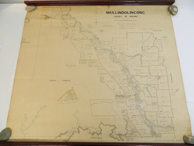
Map - Kiewa Valley, Parish Map of Mullindolingong, 12/10/1906
The map shows the names of people living in the parish of Mullindolingong in 1906. These people had leases or licences giving the reader an insight into the number of people in the area and an understanding of the size of their holdings. Infrastructure is also given including shops, schools, churches etc. Presumably it was used by the Ryder family.This map gives an historical insight into the parish of Mullindolingong as it names people and the infrastructure - roads, buildings etc. as it was in 1906. This enables the reader to compare the area at the time with other times and other places and to have an understanding of the early settlers in the area.This is a very old paper or parchment map with wooden rods top and bottom. The top rod has ribbons attached to enable hanging. The map shows the current leases and licences and when they were held by during this period, circa 1906.Mullindolingong County of Bogong. This plan has been prepared by The Most Reliable Data in the Possession of the Department up to the date of its Compilation. Information respecting Leases or Licences which await Final Completion is not recorded.parish of mullindolingong map; ryder family; early settlers; -
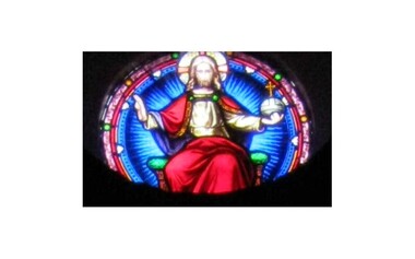 Christ Church Anglican Parish of Warrnambool
Memorial Windows: William & Sarah BATEMAN, 1869
William Bateman Snr was born to parents Daniel Bateman and Patience Wilkinson in Bradford, Yorkshire, England in approx. 1794. He married Sarah Smith on 20th November 1815 in Bradford, Yorkshire, England. They had four children – Patience (Born abt 1817), Daniel (born abt 1819) William (born abt 1831) & James (born abt 1837)all born in England. William Snr and Sarah Bateman and two sons – William and James - arrived in Australia in approx 1853. They brought with them considerable capital/stock and bought into a business in Warrnambool in William Jnr’s name. Bateman & Co rapidly became the largst mercantile business in the area and did rather extensive business with the Banks of Victoria and Australiasia. It is thought that William Snr assisted in the business to some extent, expecially financially. His other son Daniel (who remained in England) is also thought to have had a financial interest in the business as a dormant partner. The business was so prominent, Bateman & Co issued round copper tokens as a Trade Token - value one penny. These were inscribed with the Business name and were limited in their use to the business. In Sept 1856 the business was transferred to a Mr. Thos W. Sellars (nephew of William Bateman Jnr) and shortly afterwards the store closed with an order for the sequestration of the insolvents estate, but was not made absolute until December 1856 when the Insolvency court ruled for the “compulsory sequestration” of the business due to fraudulent activities within the business. But in the meantime in early November fire completely destroyed the business which left only the insurance payouts. Both William Bateman Snr and William Bateman Jnr are listed on the Pioneers’ Honour Board in the foyer of the Warrnambool Library. It is reported William Bateman Jnr was a trustee of Christ Church, was a City Councillor, and was involved in many other community organisations. He also subscribed towards the cost of building a permanent Church which was opened in 1856. William Bateman Snr died in Warrnambool on 30/03/1868 and his wife Sarah died in August 1868. William Bateman Jnr presented to Christ Church, stained glass windows in memory of his parents William & Sarah Bateman. William Bateman Jnr died in June 1913. Four stained glass windows, three lancet and one circular. The theme of the lancet windows depicts the three occasions when the apostles Peter, James and John were Jesus' sole attendants: The raising of Jairus' daughter. On the Mount of Transfiguration. In the Garden of Gethsemane. The circular window in the gable of the wall represents "The Enthroned Christ". -
 Warrnambool and District Historical Society Inc.
Audio Visual, Audio Visual - DVD (Peter’s Project)
Peter’s Project is an organization set up to raise funds for a Regional Cancer Care Centre in Warrnambool. The project was initially set up by Vicki Jellie in memory of her husband, Peter, who died of cancer some years earlier. The main aim was to build a centre for the treatment of cancer in Warrnambool so that many cancer sufferers did not have to go to Geelong or Melbourne for treatment. Government and local Council funds have been obtained for the project with the general public contributing to an appeal for $5 million. This target has been reached and the building is currently being erected. This DVD is of a May 2013 Win TV telecast of interviews and information regarding the public appeal.This DVD is of some interest as it indicates the results of one person’s campaign and the community’s response. The campaign has been very successful and will have far-reaching results. This is a plastic DVD, yellow-coloured on one side and silver on the other. It is in a white envelope with a clear plastic window. In biro – ‘Peter’s Project, Win News, May 8, 2013’ Printed on disc – TDK, Life on Record, DVD-R 1-16 x Speed, 14.7GB, DVD’ peter’s project, warrnambool regional cancer care centre -
 Warrnambool and District Historical Society Inc.
Document, Map: Lady Bay 1853, 1853
This is one of the earliest surveys and maps of Warrnambool harbor, Lady Bay. Being done in 1853, it shows the depths of the bay area marked in fathoms, currents and directions and areas of rocks around mouth of the Merri and the Western side of the bay as well as a large sand spit to the middle right of the beach region.. It also marks the large areas of seaweed and fuci in the outer bay area. It has the area of Pertobe Lagoon marked and shows the early tracks to the town. The engraving work was done by Tulloch and Brown, with Tulloch being one of the earliest engravers and lithographers in the state of Victoria. He arrived in Melbourne in 1849 and set up business with James Davie Brown in 1853 with Brown being a map engraver. They were awarded bronze and silver medals for their work at the Victorian Industrial Exhibition. He also worked in the vignettes on the Proeschel Map of Victoria.This map is of high historical and comparitive significance as it shows the Lady Bay area prior to the changes that have occurred in the last 160 years with the building of the breakwater. The issue regarding access to Lady Bay remains a current one. The engraver D Tulloch engraved some of the earliest scenes of the goldfields in Ballarat and as such has left a record of a very early and important era in Australian history. Rectangular cream paper with black text. Map area is outlined by fine black lined border. Key in top right hand corner and scale at bottom middle of map.Map is labelled Town of Warrnambool printed at top of map. Small logo at top right corner which has “Hydrographic Department” in circle around an anchor. Lady Bay Warrnambool Surveyed by John Barrow assistant surveyor Engraved by Tulloch & Brown in bottom right corner. Melbourne engraved by order of the legislative Council of Victoria in middle bottom.map, warrnambool, town of warrnambool map 1853, tulloch & brown map 1853, lady bay warrnambool,, warrnambool harbour, warrnambool breakwater, warrnambool beach