Showing 596 items matching "railway station buildings"
-
 Sunbury Family History and Heritage Society Inc.
Photograph, Royal Hotel, Pre 1936
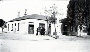
The hotel in the photograph is the original single storey Royal Hotel with its corner entrance. It stood on the south -east corner of Evans and Brook Streets in Sunbury. The original building was damaged by fire in 1936 and a two storey red brick building replaced it on the original site with the hotel entrance facing onto Brook Street. The hotel is in close proximity to the railway station so it was able to offer accommodation to travellers visiting the Asylum.The Royal Hotel is one of two surviving hotels built in Evans Street. Originally there were four hotels built between Station and Brook Streets along Evans Street.A non-digital black and white photograph of a white single story hotel building showing the original corner entrance and three men standing beside it in the street. There are two other entrances on each side and three windows down one side. The iron clad roof has three chimneys.royal hotel, sunbury, hotels, brook street, evans street -
 Sunbury Family History and Heritage Society Inc.
Photograph, Sunbury Post Office
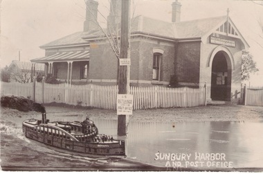
The Sunbury Post Office with a residence pictured in the image was the first official post office building in the town. It opened on the corner of Brook and Evans Streets in 1892. Prior to that time postal services were conducted in an office at Sunbury Railway Station. Although the present day post office is still on the Brook-Evans Streets corner, the building has undergone many changes in services and appearances over the years. Like many country towns, the post office offered many services to the residents over the years. short message has been written on the back to a person in Stirling WA.sunbury post office, sunbury railway station, brook street, evans street, post offices -
 Sunbury Family History and Heritage Society Inc.
Photograph, Rupertswood Viaduct
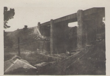
The stone bridge is one of the many bridges built along the Bendigo Rail Line. This one along with four others ar in Sunbury which were built in the late 1850s. his bridge spans the Ruoertswood Viaduct which is north of the Sunbury Station. The building in the LH corner was a pump house where water was pumped and taken to the water tower on Sunbury Station where the steam trains stopped to replenish the water tanks. The Bendigo Rail Line was the first Government owned and operated to be constructed in Victoria. Along the railway a number of famous bridges and tunnels were built and are of historical significance. The bridge spanning the Rupertswood Viaduct is one of them. A black and white photograph with a cream border of a high bridge spanning a deep valley. The roof of a small building is visible in the bottom LHS corner of the photograph.bridges, railways, rupertswood viaduct -
 Sunbury Family History and Heritage Society Inc.
Photograph
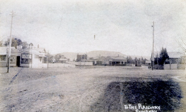
The post card is an early view of the intersection of Brook and Evans Street looking west and towards Sunbury Station. Mount Holden is in the distance. Chris Christianson's shop is on the LHS of the picture with the post office on the RHS. This image is an early view of Sunbury town centre with the railway station and post office. Like many country towns of this era, The roads have been formed but not surfaced. A sepia photograph in post card format of a view of a town centre showing an intersection and some small buildings with a hill in the distance.TO THE RAILWAY/SUNBURYbrook street, evans street, sunbury railway station, christianson, chris. -
 Sunbury Family History and Heritage Society Inc.
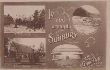
Post Card, In and around Sunbury with Greeting
... Sunbury Railway station. The buildings and places featured ...The post card is one of a set that were produced by Chris Christainsen, who had a pharmacy in Sunbury and was also a photographer. The four photos featured on the card are the Rupertswood Mansion, St Mary's Church of England, Jacksons Creek in floods ands Sunbury Railway station.The buildings and places featured on the card are of historical significance in the Sunbury town precinct. A post card with four sepia photographs of interesting sites which can be seen in the Sunbury township. IN AND AROUND SUNBURY WITH GREETING. christainsen, chris., rupertswood mansion, st. mary's church of england., jacksons creek, sunbury railway station -
 Sunbury Family History and Heritage Society Inc.
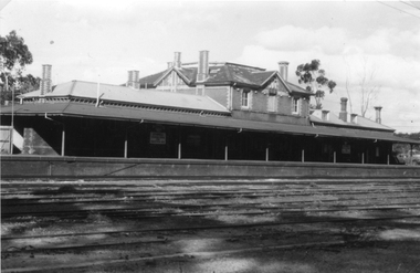
Photograph, c.1910
The building in the photograph is the Sunbury Railway Station in Brook Street and before it underwent renovations and externaL changes.The establishment of the railway in Sunbury in 1859 was an important development in the town's history and fore the Bendigo regional rail network.A black and white photograph of a weatherboard building behind a post and rail fence with a tall power pole in front of the building. A roadway is in front of the building.sunbury railway station -
 Sunbury Family History and Heritage Society Inc.
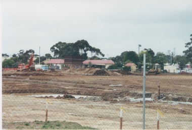
Photograph, 2000
Excavation work to remove the grasslands and trees on the railway land on the west side of the Sunbury Station to make way for commercial development on that side of the line.A coloured photograph of excavation work in operation on land which has cyclone fencing around its perimeter. There are buildings in the middle distance beyond the work site.sunbury railway station -
 Sunbury Family History and Heritage Society Inc.
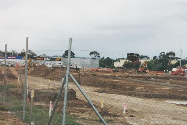
Photograph, 13 April 2000
In 2000 work commenced on the further development of railway land on the west side of Sunbury station for the construction of commercial and entertainment facilities. Prior to this time the land had been undeveloped and was often used to accommodate visiting circus troupes. Cereal storage silos also occupied this area for some time. The development of this area has been a reflection of the rapid expansion of settlement within Sunbury and surrounding areas that occurred during the early years of the twentieth century.A coloured photograph of a fenced off area undergoing development with earthmoving equipment and trucks in operation and some commercial buildings visible in the middle distance.sunbury railway station -
 Sunbury Family History and Heritage Society Inc.
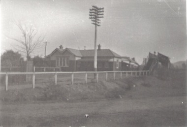
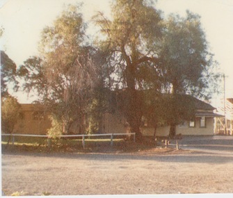
Photograph, c 1970s
The photograph is an image of Sunbury Railway Station taken in the 1970s before it underwent refurbishment and extensions in 1993 and the establishment of its surrounding garden which the Sunbury Garden Club maintain.A coloured photograph of a weatherboard building with two large peppercorn trees growing in front of it behind a low post and rail fence. sunbury railway station, brook street -
 Sunbury Family History and Heritage Society Inc.
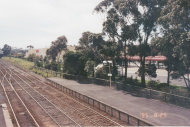
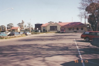
Photograph, 25th July 1995
The photograph of Sunbury Station was taken from the pedestrian bridge and is looking north to take in the Sunbury Square shopping centre buildings and the bus terminal which are on the Platform 1 or east side of the station.During the 1990s much development took place in Sunbury and the station precinct became a commercial hub.A coloured photograph of a railway station and a Coles Supermarket in the middle distance as well as a bus terminal. -
 Sunbury Family History and Heritage Society Inc.
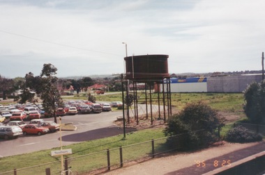
Photograph, 25th
The photograph of Sunbury was taken from the pedestrian bridge at the railway station and is looking NW to Horne Street and beyond. The water tower in the foreground was used to pump water into the steam train engines. Then commercial development on the site was built shortly before this photograph was taken.A coloured photograph of an elevated view of Sunbury with a metal water tower in the foreground and a car park with commercial buildings in the middle distance.sunbury, sunbury railway station, horne street -
 Sunbury Family History and Heritage Society Inc.
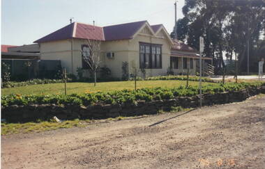
Photograph, 15th August 1995
... . Sunbury railway station Stationmaster's residence brook street ...The house was the former station master's residence. When the photograph was taken it served as a restaurant. In the late 1990s it was demolished to make way for larger commercial development.The former stationmaster's residence was one of the important buildings in Sunbury.A coloured photograph of a cream weatherboard house with light green trims surrounded by a garden. Four cars are parked outside the house.sunbury railway station, stationmaster's residence, brook street -
 Sunbury Family History and Heritage Society Inc.
Photograph, 15th
In 1993 Sunbury Railway Station underwent refurbishment and with some extensions added to the existing building. The Sunbury Garden Club undertook the task of constructing the garden on the east side of the station. The photograph was taken two tears after the completion of the work. A coloured photograph of a garden in front of a weatherboard railway station with a gravel pathway in the foreground.sunbury railway station -
 Sunbury Family History and Heritage Society Inc.
Photograph, 25th August 1995
This view of Sunbury Railway Station was taken from the corner of Brook and Evans Streets two years after the station underwent refurbishment and extensions and a carpark was constructed adjacent to the station. The Sunbury & District Heritage Association Inc. has a photograph P0663 of the station taken a century ago from the same place, when Sunbury was a small country town. The contrast between the two images is interesting. A coloured photograph of a streetscape with a weatherboard building in the middle distance,sunbury railway station, brook street -
 Sunbury Family History and Heritage Society Inc.
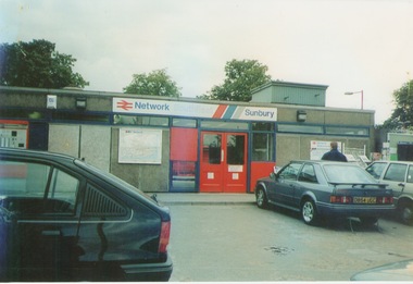
Photograph, September 1996
The photograph shows the railway station at Sunbury in Surrey in the United Kingdom. The town of Sunbury in Victoria was named after the English township of Sunbury-on-Thames in Middlesex by the Jackson Brothers who took up land in Sunbury, Victoria. The area was originally known as Koora Kooracup by the Wurundjeri people.Sunbury in Victoria like many other settlements in Australia were given names of towns in the United KingdomA coloured photograph of a railway station with three cars parked outside the building, which has grey walls and scarlet and blue trims. There are framed maps and notices on the exterior walls. -
 Sunbury Family History and Heritage Society Inc.
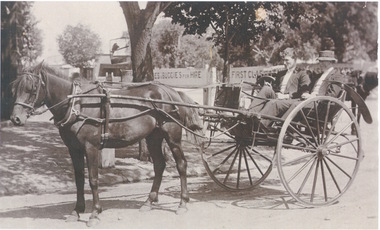
Photograph, c1900s
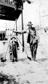
The two men in the curricle were in Brook Street outside Sunbury Railway Station.Before the advent of motor transport and buses, passengers from the train were taken by horse drawn vehicles to their destinations. An area was set aside at the station where the horses and vehicles waited for trains to arrive.A sepia photograph of two men seated in a stationary horse -drawn curricle beside a plantation area. There are two signs advertising horses and buggies for hire and some buildings are visible in the distance.curricles, brook street, sunbury, sunbury railway station -
 Stawell Historical Society Inc
Photograph, Railway Station Stawell
... grampians Railway Station Stawell. B/W photo showing large two ...Railway Station Stawell. B/W photo showing large two storey brick station with long verandah over platform in heavy shade. Rail lines in foreground. This Photograph is a copy of a Negative owned by the Society - paid from a grant 1991. This Photograph is of Stawell Railway Station.B/W. Photograph of Stawell Railway Station taken from acroos the railway tracks. Also showing two vechiles of the far right. the centre of the building is two story stawell railways, transport, mark dadswell -
 Surrey Hills Historical Society Collection
Photograph, Fred Ambler and Family
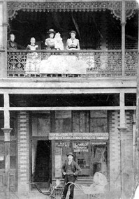
Fred Ambler and family at Albert Mills Premier Land Agency building on the corner of Union and Sunbury Roads, c.1910. Fred had his carpenter and upholstery business on the ground level and his home above. (No.1) Premier Land Agency Building, was built in 1886-7 by Albert Mills, builder, at 122 Union Road, on the corner of Sunbury Crescent, opposite the Railway Station. Photo shows his wife and family. Alfred died in 1890 and the family moved. The Boroondara Standard in 1888 reported: "Splendid block of brick buildings reaching completion in Union Road adjacent to railway line – 2 storey. Frontage 120 feet for Premier Land Agency. Shops at Ground Level." A sepia coloured photograph of a two storey terrace building with 3 ladies and 2 children standing on the balcony. Downstairs, a gentleman stands outside the shopfront beside two prams. There is a child in one pram.albert mills premier land agency building, (mr) fred ambler, union road, carpenter, upholsterer, sunbury crescent -
 Surrey Hills Historical Society Collection
Photograph, Churchill Street, Mont Albert and Mont Albert Station, looking towards Hamilton Street, 1919, 1919
The railway extended through to Mont Albert in 1882, but it wasn't until 1890 that a station was built with funds raised by a syndicate of local landowners.The buildings on the south side of the railway were built in 1910-1911 in the Arts and Crafts style by architect, K W Hardy. The land occupied by the Hamilton Street shops was subdivided in the 1880s and the first purpose-built shop was 'Pope and Moran, Grocers'. This shop later became Tom Morris' Grocery. By 1930 shops stretched along both sides of Hamilton Street and part way along Churchill Street. The donor, the late Norman Carter held a significant collection of photos taken around Mont Albert and Surrey Hills, in particular subjects related to the Church of England.Black and white photo taken from the centre of the road in Churchill Street, Mont Albert. Mont Albert station is on the RHS fenced off by a post and rail fence. Shops can be seen at the intersection of Hamilton and Churchill Streets. There do not appear to be any shops in Churchill Street. There are newly planted street trees within paling guards on the LHS. There does not appear to be any curb and channelling at the side of the road.Rear in blue biro in Jocelyn Hall's handwriting "Mont Albert Station 1919".mont albert station, railways, hamilton street, churchill street, shops, arts and crafts style, norman carter -
 Surrey Hills Historical Society Collection
Photograph, Surrey Hills railway station, 1973, 1973
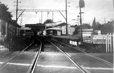
This would have been taken shortly before the station was demolished.Black and white photo of Surrey Hills railway station taken from the tracks near the gates in 1973. It shows the wooden pedestrian overpass and the original station buildings with extended shelters over the platforms.There is a newspaper kiosk on the southern platform. The train is coming into the platform and there is a small group of passengers waiting. Advertising hoarding for Spaceline Homes and the Frankston Caravan Park are mounted at the end of the southern platform. railways, land transport, surrey hills railway station -
 Surrey Hills Historical Society Collection
Photograph, Surrey Hills Station and car park
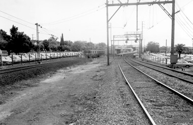
There are 3 tracks; the third track was built in 1971, which gives an approximate date for the photo. At this time the original station buildings were demolished and replaced by buildings constructed from concrete bricks and a second subway replaced the overhead footbridge. According to Roderick Smith, a local railway enthusiast, originally there had been 3 railway houses at the Mont Albert end of the northern car park. These were demolished to extend the car park. Certainly 8 Bedford Avenue, built as the station master's house was demolished at this time. The palm tree had been planted in the station master's front garden and was retained in a small garden bed within the car park. A black and white photograph of a station with cars parked on both sides of the 3 tracks. A Harris train is departing the station heading towards Mont Albert. A palm tree is prominent in the station car park to the north.1971, surrey hills station, railway stations, car parks, public transport, trains, railway lines, palm tree -
 Surrey Hills Historical Society Collection
Photograph, Fred Lyons and his son Arthur after a hail storm, 1924, 1924
Lyons family history: Frederick Adolphus (Fred) Lyons operated a cab / taxi service in Union Road for several decades. Arthur was the only son of Frederick Adolphus Lyons (1891-1980) who was born in Surrey Hills, son of Thomas and Catherine Lyons. He married Elizabeth Ruby Hall in 1918. They lived at 55 Sunbury Crescent. The Lyons’ home was called ‘Knopshambury’ - this was probably a misspelling of Knockshanbally in Co Kilkenny, the birth place of Fred’s father, Thomas Edmund Josias Lyons (1846-1915).Arthur Lyons was born in Surrey Hills on 12 Jun 1920. He became a motor mechanic / welder and lived his whole life at 55 Sunbury Crescent. This is one of a series of photos donated by Arthur Lyons. The donation was made while he was in hospital. He died shortly afterwards (23 Sep 1990). Donation was finalised by a neighbour, Mrs Florence Ann Armitstead, wife of Glen Victor Armitstead. Glen was a local hairdresser. They moved to 11 Sunbury Crescent after their marriage in 1939. Arthur had no relatives to distribute the material to. The hail storm occurred on 2 December 1924.Despite the poor condition, this is significant because of the clear detail of the Union Road buildings and railway crossing in the background in 1924.Black and white photo of cab driver Fred Lyons with his son Arthur taken at the cab rank near the Surrey Hills station, clearing up after a hail storm in 1924. Fred balances 2 large shovels; Arthur has an over-sized jacket on. The railway gates and overhead lines can be clearly seen in the background. Despite the poor condition, it is a relatively significant photo as it details Union Road buildings and the railway crossing clearly behind it.On back of photo is written in pencil "copied 1996" and in blue pen "2/12/24"railway crossings, hail storms, frederick adolphus lyons, fred lyons, arthur frederick lyons, arthur lyons -
 Surrey Hills Historical Society Collection
Photograph, Arthur Lyons in Union Road after a hail storm, 1924, 1924
The hail storm occurred on 2 December 1924. This is one in a series from the Lyons' photo collection. This was gifted to the SHNCHC by Arthur Frederick Lyons, son of Frederick Alphonsus (Fred) Lyons and Elizabeth Ruby Hall, who married in 1918. Fred Lyons died 4/10/1980. The Lyons’ home in Sunbury Crecent was called ‘Knopshambury’ - this was probably a misspelling of Knockshanbally in Co Kilkenny, the birth place of Fred’s father, Thomas Edmund Josias Lyons (1846-1915). Arthur was born in Surrey Hills on 12 Jun 1920. He became a motor mechanic / welder and lived at 55 Sunbury Crescent. The donation was made while he was in hospital. He died shortly afterwards (23 Sep 1990). Donation was finalised by a neighbour, Mrs Florence Ann Armitstead, wife of Glen Victor Armitstead. Glen was a local hairdresser. They moved to 11 Sunbury Crescent after their marriage in 1939. Arthur had no relatives to distribute the material to.Historically significant as it shows clearly the buildings and railway crossing in Union Road.Black and white photo of Arthur Lyons as a child with a shovel in hand taken at the cab rank near the Surrey Hills station, clearing up after a hail storm in 1924. The railway gates and overhead lines can be seen in the background. On back in pencil was "Copied 1996" and also "2/12/1924"railway crossings, hail storms, arthur lyons -
 Surrey Hills Historical Society Collection
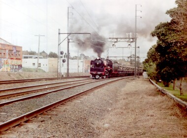
Photograph, A Yarra Glen Special approaching Surrey Hills, 1986
A Yarra Glen Special in 1986 at Surrey HillsA coloured photograph of a steam train bellowing lots of smoke approaching Surrey Hills station. On the LHS is Stirling Crescent; on the RHS is Sunbury Crescent. There is graffiti on the buildings adjacent to the railway line on the LHS.On rear of photo : "A Yarra Glen Special / 1986/ at Surrey Hills"graffiti, surrey hills, steam train, trains, 1986, harris carriages -
 Surrey Hills Historical Society Collection
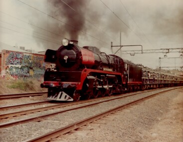
Photograph, Yarra Glen Special at Surrey Hills in 1986
Steam Rail Victoria is a Preservation Society which runs tour specials throughout Victoria. This particular train is being pulled by an R Class loco on a Yarra Glen Special. The carriages behind are Blue Harris carriages which were normally used on the electrified system. the train is approaching Surrey Hills from Chatham station.A coloured photograph of a Steam train blowing steam as it plows along pulling a number of blue carriages. There is some graffiti on the back of a building that backs onto the railway line.On back of photo: "A Yarra Glen Special / 1986 / At Surrey Hills"graffiti, surrey hills, steam trains, trains, 1986, harris carriages -
 Port Fairy Historical Society Museum and Archives
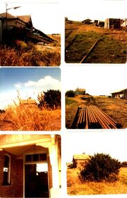
Photograph - Photographic montage
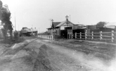
6 photographs of railway station in ruins before removal from siteDocuments the neglect of the railway station in the late 1970’s before the removal of the equipment and buildings6 coloured photographs in collage of dilapidated station transport, rail, road, derelict, railway, station -
 Surrey Hills Historical Society Collection
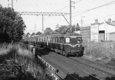
Unknown - Digital photo, George L Coop, Harris train at Mont Albert railway station c 1964, c1964
The train is headed towards Surrey Hills station. In the background are the Hamilton Street shops with advertising posters on their rear walls. The donor George Lister Coop was about 27 years of age when he took this photo. It is one of a small series of photos donated by him that relate to Mont Albert and Surrey Hills stations. He has always had an interest in railways and there are other examples of his documentation of railway history in other collections contributing to this database. A black & white photo of a Harris train destined for Flinders Street that has passed through Mont Albert station, which can just be seen in the background. Behind the train on the rear walls of buildings are advertising for Haydn Real Estate and K&M Murray selling Toppa Ice Cream.advertising signs, george l coop, mont albert station, trains, haydn real estate, toppa ice cream, k & m murray, hamilton street shops -
 Surrey Hills Historical Society Collection
Digital photo, George L Coop, Mont Albert Railway Station c 1956, c1956
The donor George Lister Coop was about 19 years of age when he took this photo. It is one of a small series of photos donated by him that relate to Mont Albert and Surrey Hills stations. He has always had an interest in railways and there are other examples of his documentation of railway history in other collections contributing to this database. This documents the original building on the northern platform of the Mont Albert station. The railway line was extended out to Lilydale with work commencing in 1882. It is not known exactly when the Mont Albert station was built, but it opened in 1890. It is presumed that this building was demolished when the third line was constructed in 1971. At this time the nearby Surrey Hills original station buildings were demolished.A black & white photo of Mont Albert station taken from the north platform adjacent to High Street, looking towards Box Hill. It clearly shows the bend in the line beyond the platforms. it also shows both the original buildings; the one on the north side having been demolished. There is a lady on the south platform adjacent to Hamilton Street. The roof line only of one of the Hamilton Road shops can be seen.george lister coop, mont albert station, 1956, hamilton street shops -
 Canterbury History Group
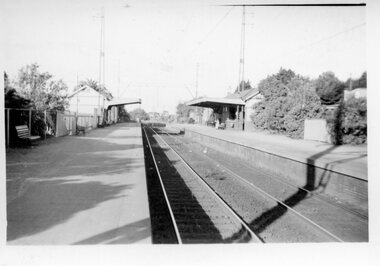
Photograph - Canterbury railway station, c1966
... Railway Stations Station buildings and line viewed from the north ...Station buildings and line viewed from the north c1966 Black and white photographcanterbury, canterbury railway station, canterbury road, railway stations -
Canterbury History Group
Photograph - Canterbury station buildings, c1966
Ticket box and restrooms viewed from the north c1966. Black and white photographcanterbury, canterbury station, canterbury road, railway stations