Showing 6383 items
matching Mining
-
 Federation University Historical Collection
Book, Ballarat School of Mines Students' Magazine, 1902-1906
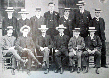
The Ballarat School of Mines is a predecessor institution of Federation University Ausgtralia.Five copies of the Ballarat School of Mines Students' Magazine bound in a blue hard cover and quart bound in calf. 1902 - Retirement of Herbert L. Krause 1905 - Mt Lyall Ore Deposits Images: Ballarat School of Mines Sports Association Committee and Officers, 1905 Standing left to right: W. Pearce, T. Williams, S. Hepburn, Seward, W. Figgis, J.R. Reid, P. Elliott Sitting left to right: P.A. Pratt, N. Buley, John Sutherland, H.R Murphy, J. Inglis, R. Nevett 1906 Excursion to Broken Hill, The Artistic Printing Process, Hints on Portraiture, Arizona, Cornish Mining Images Ballarat School of Mines and AusImm at the Central Mine, Broken Hill; At Iron Knob, Brown Boveri Turbo Generator at Block 10, Junction Mine plant or Potter Process, Broken Hill Propriety Mill, Carlyon's Hotel, Sam Jamieson, Electrical Labortory, Ballarat School of Mines Rowing Eight, Sports Committee,ballarat school of mines, magazines, sports committee, thomas williams, mount lyell, w. pearce, t. williams, s. hepburn, seward, w. figgis, j.r. reid, p. elliott, p.a. pratt, n. buley, john sutherland, h.r murphy, j. inglis, r. nevett, herbert l. krause, broken hill, artistic printing process, hints on portraiture, arizona, cornish mining, ausimm at the central mine, broken hill, iron knob, brown boveri turbo generator at block 10, junction mine plant or potter process, broken hill propriety mill, carlyon's hotel, sam jamieson, electrical labortory, ballarat school of mines rowing eight, sports committee,, rowing on lake wendouree, boat shed, h. valentine, l. seward, c. macgennis, d. don, m. gaunt, h. owne, l. nott, s. leathes, j.a. reid, h.r. murphy, alfred mica smith, r. hosking, zeehan, moonta, wallaroo, smelting silver, south africa, south australia excursion, sunnyside woollen mills, tasmanian excursion, swedish iron, mt jukes excurson, western australian gold ore, wynne-grant furnace, bhp sintering slimes, leggo furnace, mine ventilation, mount morgan mine, mount pani ltd, new zealand coal, adelaide school of mines, students' association, at iron knob, ausimm, excursions, visits, south australian excursion -
 Bendigo Historical Society Inc.
Newspaper - JENNY FOLEY COLLECTION: SNIPPETS OF BENDIGO
Bendigo Weekly - Snippets of Bendigo History, The Pall Mall story, part one - By Edith Lunn. Pall Mall was the vision of Richard Larritt who, from the Survey Office (Dudley House) at the top of View Street created order out of the chaos of the early alluvial mining activities along the Bendigo creek. Much history attaches to Pall Mall. The Freemasons' hotel, built in 1858, later renamed the Court house hotel, stands on the Mundy Street corner. In 1902 Sidney Myer opened his first shop close by. Bill Hampton had a grocery business and Colin Creek was a butcher in this block. On the Bull Street corner, Taylor Bros erected a two storied building for their drapery business. Crossing over Bull Street the former Commercial hotel stood on the corner from 1868. Many different shops filled the block to Williamson Street, they included Mr and Mrs Pedersen's café, the Gas Company's office, Fontawayne's frock shop, Hume and Iser, Doug Pain jeweller. The clip is in a folder.newspaper, bendigo, bendigo weekly -
 Bendigo Historical Society Inc.
Document - NORTH DEBORAH GOLD MINING CO N. L. - MINERS' WAGES AT THE DEBORAH MINES, 1953
Carbon copy notes, which have been cut in half, listing Miners' Wages at the Deborah Mines, 1953. Wages are for a 5 day, 40 hour week and in present day currency. Miners received $27.20 or $35.25 if a Leader in a wet shaft. Braceman $25.80, Platman $25.80 or $27.05 if he worked in a wet shaft. A Mining Blacksmith $28.55, a Fireman, from $26.10 to $26.60, Winding Engine Driver $30.05 a week. Batteryman $25.10, battery Feeder $24.80. Engine Driver's wages varied from $27.10 to $28.90 if in charge of a dynamo and plant. The Basic Wage was then $23.20 a week. In 1895, employees worked a 6 day, 48 hour week and most men received less than $5 per week. The price of gold in 1949 was $30.98 compared with an average of $8.00 an ounce in 1895. When the Deborah group of mines closed in 1954 the price of gold was $31.25 an ounce. Signed by A Richardson 20/8/1971. Written in the margin: Copy, Compiled for Jim Sullivan 20/8/1971.document, gold, north deborah gold mining co n. l., north deborah gold mining co n. l., miners' wages at the deborah mines 1953, miners' wages, price of gold, jim sullivan -
 Bendigo Historical Society Inc.
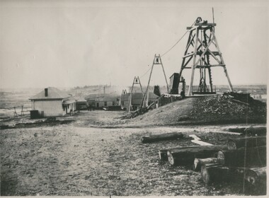
Photograph - GREAT EXTENDED HUSTLERS MINE, 1875
black and white photograph of the Great Extended Hustlers Quartz Mining claim. Photograph shows five weatherboard clad buildings with corrugated iron roofing. Poppet legs and cable support trestles. Bush logs in foregound at right. Office at left, battery house centre background. Main shaft right. Copy of original photo. On face of photo in indian ink: area of 24 acres, has 6 shafts, equals 4000 feet of sinking. No less than 13 levels and 16 x cuts making a total of 12000 feet. Amount spent in labour 228,000 ( pounds stg. ) Quartz raised 144,5000 tons and yields to date 188,000 ozs of gold. Dividends 585,000 ( pounts st.) nearly 20/-/ a share. Employment to nearly 200 men. It is stated this rich mine changed hands the early days for only 30/-/-. On back in black ink ' Gr. Extended Hustlers. Bottom right corner : A. Richardson/29 Harrison Street/Bendigo.N.J. Caireorganization, business, great extended hustlers mine -
Bendigo Historical Society Inc.
Document - NEW CHUM LINE OF REEF - EXTRACTS FROM WM WELCH'S BOOKS
Three pages of notes on Garibaldi, Ellesmere Co No 1, New Chum Consolidated Co N. L.,New Chum United Co, Lazarus New Chum Co Reg'd and Lazarus New Chum No 1. Notes include Legal Manager, Mining Manager, size od lease, machinery, information on shares and dividends. Henry von der Hyde was the Legal Manager of the Garibladi and W Martin, the Mine Manager. John Neeson, the Legal Manager of the Ellesmere Co No 1 and Henry Reed, Mine Manager. Henry Von der Hyde, Legal Manager of New Chum Sonsolidated Co N L and Thomas Sheppard, Mine Manager. Henry von der Hyde, Legal Manager of New Chum United N L and John Harvey, Mine Manager. Lazarus New Chum Co Reg'd and Lazarus New Chum No 1 Co Reg'd, Henry von der Hyde, Legal Manager and George Armstrong, Mine Manger to both companies.document, gold, new chum line of reef, new chum line of reef, extracts from wm welch's books, garibaldi mining & crushing co n l, henry von der hyde, w martin, ellesmere co no 1 n l, john neeson, henry reed, new chum consolidated co n l, thomas sheppard, menzies claim, new chum united co n l, john harvey, bonate's claim, old new chum, geo lansell, lazarus new chum co reg'd, lazarus new chum no 1 co reg'd, george armstrong, gibbs, lazarus, wm welch's bendigo gold mines 1883, wm welch's bendigo mining registry, wm welch's guide to the bendigo gold mines -
 Bendigo Historical Society Inc.
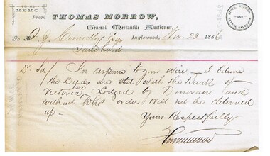
Document - CONNELLY, TATCHELL, DUNLOP COLLECTION: LEGAL PAPERS
Documents. Connelly, Tatchell & Dunlop - Legal Papers. 1 - 1886 - Letter from Crawford W H, Ballarat. 2 - 1886 - Letter from Bennett, Attenborough, Wilks & Nunn, Solicitors, Melbourne re Carmody to Gooding. 3 - 1886 - Letter from Smith C L re Haskers application for Gold Mining Lease. 4 - 1886 - Letter from Bennett, Attenborough, Wilks & Nunn, Melbourne re Lazarus v Lazarus. 5 - 1886 - Letter from Bennett, Attenborough, Wilks & Nunn, Melbourne re Gibbins v Morrow. 6 - 1886 - Letter from Bennett, Attenborough, Wilks & Nunn, Melbourne re Sterry v Trestrail. 7 - 1886 - Letter from Morrow Thomas, General Mercantile Auctioneer, Stock Station & Estate Salesman, Inglewood re Gibbins. 8 - 1886 - Letter from Hughes D T re Maxwell & Adams, 9 - 1886 - Letter from Morrow Thomas, General Mercantile Auctioneer, Inglewood.cottage, miners, connelly, tatchell & dunlop, crawford w h, bennett attenborough wilks & nunn, carmody, gooding, smith c l, haskers, lazarus, gibbins, morrow, sterry, trestrail, hughes d t, maxwell & adams, morrow thomas -
Bendigo Historical Society Inc.
Document - DRAINAGE PROBLEMS - NEW CHUM MINES THE DRAINAGE QUESTION
Handwritten extract from the Bendigo Advertiser Jan 2nd 1911. ''In absence of Mr McBride, Minister for Mines in the country, officers of the Mines Department were inclined to-day to say much about unwatering the deep Bendigo mines, which is again a pressing problem. Owing to the breaking of the steel wire rope at the victoria Quartz mine, the trouble was intensified. An arrangement had been made by which the companies affected along the line should contribute, but two of the companies, it is stated, suspended operations. A scheme has been placed by Mr Stanfield before the parties interested, and the officers of the Mines Department expressed the hope that for the sake of the future of deep mining, some arrangement should be come to. Unless the companies show a disposition to help themselves substantially, the officers do not think it likely that the Government will co-operate. There are, it was added certain provisions of the Mines Act, and covenants in leases can be enforced, but there is no desire to compel the companies which have carried on in the face of great difficulties, to do anything reasonable.''document, gold, drainage problems, drainage problems, new chum mines the drainage question, bendigo advertiser 2/1/1911, mr mcbride, mines department, victoria quartz mine, mr stanfield, mines act -
 Bendigo Historical Society Inc.
Document - ARTICLES FOR ROYAL HISTORICAL SOCIETY (BENDIGO BRANCH) JUNE 1973
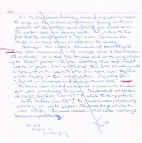
Articles for Royal Historical Society (Bendigo Branch) June 1973. 1. Article re two aspects of New Chum Railway mine - a. the shaft has a 180 degree 'twist' in it; b. ventilation problems at depth (4236 feet level); 2. Specimen Hill Methodist Church - mention of Mining Inspector Grainger; Mr Widdox; Blazier (Braizer)?? & Co - contractors; Rev. Rankin; Mr Manley; Brass Band; Rev. Winn. 2. ''The new bells - St Paul's Church, Bendigo'' - mention of Mears and Stainbank (Bell Foundry, Whitechapel, London); Rt Rev R E Richards (Bishop of Bendigo); re-casting of bells 1964. 3. Article re artificial ventilation re West Berry Consols Mine (Allendale) and use of a Roots Blower. 4. Article ''It slowly fades away'' re demolition of 46 Lucan Street (see also Moaic #2860) - mention of Thunders Brewery; Bendigo Cognac Distillery; Cyril Michelsen; John Michelsen; description of vats and layout of site.document, names of bendigo pioneers, bendigo -
 Bendigo Historical Society Inc.
Document - MCCOLL, RANKIN AND STANISTREET COLLECTION: NORTH VIRGINIA GOLD MINING CO NL, JOHN SHAW LTD, 1939
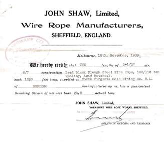
McColl Rankin & Stanistreet, North Virginia Gold Mining Co NL. a/ John Shaw Ltd, Wire Rope Manufacturers, Sheffield England. Certificate that 2 lengths of 2-1/2 cir. 6/7 construction Best Black Plough Steel Wire Rope, Quality, Acid Material. 100/110 ton each 1250 feet long supplied. Breaking strain of not less then 24.8 actual tons. Stamped: For Hardware of Australia Propriety Limited. Signed: ?? (attached by pin to b) b/ Hardware Co. Of Australia, Iron & Steel Merchants, South Melbourne. Descriptions per (a) 109.7.3 Signed: Hunt. Dated 15/11/1939. c/ Test Certificate For Wire Ropes Issued to J R Reid & Sons. Rope dispatched per S.S.''Mildura'' to Melbourne on 3.12.1946.Tested in the presence of A Boots, Abbott Supply Coy. Pty. Ltd. For the Australian Wire Rope Works Pty Ltd. Signed: J Humphy. Dated: 6/12/1946. Includes picture.organization, business, gold mine, mccoll rankin & stanistreet, north virginia gold mining co nl. a/ john shaw ltd, wire rope manufacturers, sheffield england 6/7 construction best black plough steel wire rope quality acid material 100/110 ton each 1250 feet long supplied reid & son -
 Melbourne Tram Museum
Magazine, Institute of Engineers Australia (IEAust), Journal of the Institution of Engineers Australia" - Vol 6, No. 10, Oct. 1934, "Metropolitan and Provincial Tramways", Oct. 1934
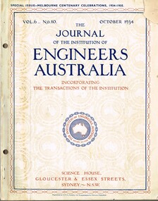
Journal or magazine - stapled pages approx. 100 printed on semi gloss paper, with glue outside cover, titled Journal of the Institution of Engineers Australia" - Vol 6, No. 10, Oct. 1934 - Special issue - Melbourne Centenary Celebrations 1934 - 1935. Contains transactions of radio frequency, institution and related activities, and 100 years of Engineering in Victoria. These include maps of Victoria and Melbourne, Engineering Education (Kernot), Metropolitan Roads and Bridges by J. Noble Anderson City Engineer of Richmond, Country Roads and Bridges, Railway Development (VR), Metropolitan and Provincial Tramways (Strickland and Russell), Port of Melbourne, Outer ports, air transport, water supply, sewerage and drainage, gas industry, electricity supply, communications (telephone and telegraph), industrial development and mining. Has ads for British Insulated cables, Thompsons Engineer, Goodyear, GEC - British General Electric, Associated General electric, Vickers and many other companies. Photocopy of article from the Bob Lilburn collection.trams, tramways, centenary, victoria, tramways, railways, secv, mmtb, cable trams -
 Marysville & District Historical Society
Photograph (item) - Colour photograph, Unknown
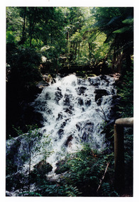
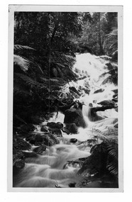
A colour photograph of the Cora Lynn Falls near Marysville in Victoria.A colour photograph of the Cora Lynn Falls near Marysville in Victoria. These falls are located on the Marysville-Wood's Point Road. Cambarville is notable for its giant mountain ash (Eucalyptus regnans) trees within the Cumberland Memorial Scenic Reserve, and relics from former sawmills and gold mining. The Big Culvert is located nearby on the Marysville - Woods Point Road, which was historically part of the Yarra Track. Cambarville was established as a timber mill town in the 1940s. Timber mill owners A Cameron and FJ Barton named Cambarville. They established the mill to salvage timber from trees destroyed in the 1939 bushfires. Cambarville was impacted by the 2009 Black Saturday bushfires and any remaining structures were destroyed.marysville, victoria, photograph, cora lynn falls, waterfalls, cambarville, marysville-wood's point road, eucalyptus regnans, cumberland memorial scenic reserve, mining, big culvert, yarra track, a cameron, fj barton, 1939 bushfires, 2009 black saturday bushfires, timber mills -
 Marysville & District Historical Society
Photograph (item) - Black and white photograph, 1935
An early black and white photograph of the Cora Lynn Falls near Cambarville in Victoria.An early black and white photograph of the Cora Lynn Falls near Cambarville in Victoria. These falls are located on the Marysville-Wood's Point Road. Cambarville is notable for its giant mountain ash (Eucalyptus regnans) trees within the Cumberland Memorial Scenic Reserve, and relics from former sawmills and gold mining. The Big Culvert is located nearby on the Marysville - Woods Point Road, which was historically part of the Yarra Track. Cambarville was established as a timber mill town in the 1940s. Timber mill owners A Cameron and FJ Barton named Cambarville. They established the mill to salvage timber from trees destroyed in the 1939 bushfires. Cambarville was impacted by the 2009 Black Saturday bushfires and any remaining structures were destroyed.marysville, victoria, photograph, cora lynn falls, waterfalls, cambarville, marysville-wood's point road, eucalyptus regnans, cumberland memorial scenic reserve, mining, big culvert, yarra track, a cameron, fj barton, 1939 bushfires, 2009 black saturday bushfires, timber mills -
 Marysville & District Historical Society
Photograph (item) - Black and white photograph, Unknown
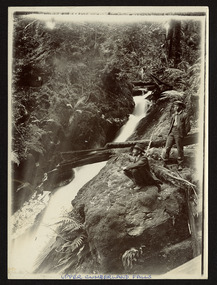
An early black and white photograph of the Upper Cumberland Falls in the Cumberland Valley in Victoria.An early black and white photograph of the Upper Cumberland Falls in the Cumberland Valley in Victoria. These falls are located on the Marysville-Wood's Point Road. Cambarville is notable for its giant mountain ash (Eucalyptus regnans) trees within the Cumberland Memorial Scenic Reserve, and relics from former sawmills and gold mining. The Big Culvert is located nearby on the Marysville - Woods Point Road, which was historically part of the Yarra Track. Cambarville was established as a timber mill town in the 1940s. Timber mill owners A Cameron and FJ Barton named Cambarville. They established the mill to salvage timber from trees destroyed in the 1939 bushfires. Cambarville was impacted by the 2009 Black Saturday bushfires and any remaining structures were destroyed.UPPER CUMBERLAND FALLScumberland falls, cambarville, marysville, victoria, waterfalls, postcard, souvenir, mountain ash, mining, timber mills, big culvert, yarra track, a cameron, fj barton, black saturday bushfires, 1939 bushfires, eucalyptus regnans -
Marysville & District Historical Society
Flyer (item) - Information flyer, Artworkz Tourism, Marysville-Cora Lynn Falls, 20-04-2018
A flyer that was produced as a guide to the Cora Lynn Falls near Marysville in Victoria.A flyer that was produced as a guide to the Cora Lynn Falls near Marysville in Victoria. These falls are located on the Marysville-Wood's Point Road. Cambarville is notable for its giant mountain ash (Eucalyptus regnans) trees within the Cumberland Memorial Scenic Reserve, and relics from former sawmills and gold mining. The Big Culvert is located nearby on the Marysville - Woods Point Road, which was historically part of the Yarra Track. Cambarville was established as a timber mill town in the 1940s. Timber mill owners A Cameron and FJ Barton named Cambarville. They established the mill to salvage timber from trees destroyed in the 1939 bushfires. Cambarville was impacted by the 2009 Black Saturday bushfires and any remaining structures were destroyed.marysville, victoria, photograph, cora lynn falls, waterfalls, cambarville, marysville-wood's point road, eucalyptus regnans, cumberland memorial scenic reserve, mining, big culvert, yarra track, a cameron, fj barton, 1939 bushfires, 2009 black saturday bushfires, timber mills -
Marysville & District Historical Society
Booklet (item) - Information booklet, Artworkz Tourism, Cora Lynn Falls, Unknown
An information booklet that was produced as a guide to the Cora Lynn Falls near Marysville in Victoria.An information booklet that was produced as a guide to the Cora Lynn Falls near Marysville in Victoria. These falls are located on the Marysville-Wood's Point Road. Cambarville is notable for its giant mountain ash (Eucalyptus regnans) trees within the Cumberland Memorial Scenic Reserve, and relics from former sawmills and gold mining. The Big Culvert is located nearby on the Marysville - Woods Point Road, which was historically part of the Yarra Track. Cambarville was established as a timber mill town in the 1940s. Timber mill owners A Cameron and FJ Barton named Cambarville. They established the mill to salvage timber from trees destroyed in the 1939 bushfires. Cambarville was impacted by the 2009 Black Saturday bushfires and any remaining structures were destroyed.marysville, victoria, photograph, cora lynn falls, waterfalls, cambarville, marysville-wood's point road, eucalyptus regnans, cumberland memorial scenic reserve, mining, big culvert, yarra track, a cameron, fj barton, 1939 bushfires, 2009 black saturday bushfires, timber mills -
 Marysville & District Historical Society
Photograph (Item) - Black and white photograph, Way to Cumberland Falls, c1900
An early black and white photograph of the forest near the Cumberland Falls in Victoria.An early black and white photograph of the forest near the Cumberland Falls in Victoria. The falls are located on the Marysville-Wood's Point Road. Cambarville is notable for its giant mountain ash (Eucalyptus regnans) trees within the Cumberland Memorial Scenic Reserve, and relics from former sawmills and gold mining. The Big Culvert is located nearby on the Marysville - Woods Point Road, which was historically part of the Yarra Track. Cambarville was established as a timber mill town in the 1940s. Timber mill owners A Cameron and FJ Barton named Cambarville. They established the mill to salvage timber from trees destroyed in the 1939 bushfires. Cambarville was impacted by the 2009 Black Saturday bushfires and any remaining structures were destroyed.ARMSTRONG COLLECTION 42 STATION STREET/ SANDRINGHAM 3191/ TEL. (03) 9521 5442/ IAN M.L. ARMSTRONG OAMcumberland falls, cambarville, marysville, victoria, waterfalls, postcard, souvenir, mountain ash, mining, timber mills, big culvert, yarra track, a cameron, fj barton, black saturday bushfires, 1939 bushfires, eucalyptus regnans -
 Marysville & District Historical Society
Photograph (Item) - Black and white photograph, Cumberland Falls, c1900
An early black and white photograph of Cumberland Falls near Marysville in Victoria.An early black and white photograph of Cumberland Falls near Marysville in Victoria. These falls are located on the Marysville-Wood's Point Road. Cambarville is notable for its giant mountain ash (Eucalyptus regnans) trees within the Cumberland Memorial Scenic Reserve, and relics from former sawmills and gold mining. The Big Culvert is located nearby on the Marysville - Woods Point Road, which was historically part of the Yarra Track. Cambarville was established as a timber mill town in the 1940s. Timber mill owners A Cameron and FJ Barton named Cambarville. They established the mill to salvage timber from trees destroyed in the 1939 bushfires. Cambarville was impacted by the 2009 Black Saturday bushfires and any remaining structures were destroyed.ARMSTRONG COLLECTION 42 STATION STREET/ SANDRINGHAM 3191/ TEL. (03) 9521 5442/ IAN M.L. ARMSTRONG OAMcumberland falls, cambarville, marysville, victoria, waterfalls, postcard, souvenir, mountain ash, mining, timber mills, big culvert, yarra track, a cameron, fj barton, black saturday bushfires, 1939 bushfires, eucalyptus regnans -
Bendigo Historical Society Inc.
Document - BOOKLET NOTES - SADDLE REEFS AND SPURS
Handwritten notes titled 'Saddle Reefs and Spurs'. The notes were written to replace 'The Reefs' in a previous booklet. Notes describe saddle reefs and spurs, the different terminology relating to them, why some reefs were richer than others, where the shaft was positioned relating to the reef and the description of spurs and where they occur.document, gold, booklet notes, mining, booklet notes, saddle reefs and spurs, j n macartney, bendigo goldfield registry 1870, collman, lancashire line, nell gwynne line, new chum line, sheepshead line, garden gully line, collman and tacchi, great extended hustlers, a r -
 Eltham District Historical Society Inc
Photograph, Peter Pidgeon, Grave of Beulah Alice Rutter and children, June and Samuel, Eltham Cemetery, Victoria, 5 April 2021
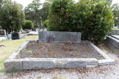
Hubert and Beulah Alice (Simpson) Rutter had five children: Hubert Jnr. (Joe) in 1913, David in 1915, June in 1917, Donald in 1922 and Samuel in 1926. Samuel died as an infant aged 17 days. Hubert was a notable figure in Eltham and beyond, with a career as a mining manager in Australia and Malaya. He served in the AIF in the First World War. While the children were growing up at ‘Yarra Braes’, Eltham, their father was an Eltham Shire Councillor in the 1920s, shire president in 1928 and a leading figure in establishing the Shire of Eltham War Memorial League, which was responsible for building the Shire of Eltham War Memorial tower at Kangaroo Ground, near where the Shire Offices were located until the 1930s. The Rutter name was commemorated after the war at Eltham High School with one of the schoolhouses named ‘Rutter House’ and at Geelong Grammar School until the 1960s where a ‘Rutter Badge’ was awarded to junior boys for leadership. The family home, ‘Yarra Braes’ was destroyed in the devasting Black Friday bushfire, 13 January 1939 and Beulah relocated to Toorak, Hubert working in Western Australia. Tragedy struck the family again December 19, 1940 when daughter June was killed after falling from the Heidelberg train on to an adjacent track into the path of a Reservoir train at Victoria Park station. Sons David and Donald both served in the R.A.A.F. during the Second World War and were killed in action, David in Libya in 1941 and Donald in Germany in 1945. The wreck of his plane and his body were not recovered at the time and Hubert never ceased to chase down leads as to his whereabouts. Beulah never gave up hope that Donald was still alive. Hubert had received several reports shortly after the war that his son was still alive but these were ultimately accepted as misidentification. Such was the anguish of the grieving parents, their son’s plane not found to confirm the fact for certain. Hubert wrote to the Air Force in frustration, failing to understand how the plane could disappear when it crashed in a relatively populated area. Unfortunately the answers came too late for Beulah who died in 1946 and was buried in Eltham Cemetery along with her daughter June and baby Samuel. Donald’s plane was eventually located and his body recovered in 1949. He is buried in the Hanover War Cemetery, Germany. David is commemorated on Column 245, Alamein Memorial, Egypt. Both David and Donald are commemorated on Eltham’s Roll of Honour Board, commissioned by the Eltham War Memorial Trust to be hung in the Baby Health Centre, part of the Eltham War Memorial building precinct. Hubert Senior and Hubert Junior both continued to work in the mining industry in Western Australia. Hubert senior died 1957 at Plantagenet Western Australia and Hubert junior in 1979 at Gascoyne, Western Australia. Sacred to the memory of Beulah AliceBeloved wife of Hubert Rutter Died August 21st 1946 also June Beloved daughter of Beulah and Hubert Rutter Died 19th December 1940 aged 23 years Also her baby brother Samuel Died 7th October 1926, aged 17 daysBorn Digitaleltham cemetery, gravestones, beulah alice rutter, hubert rutter, june rutter, samuel rutter -
 Ballarat Heritage Services
Photograph - Photograph - Colour, Clare Gervasoni, Nimon's Bridge, 1999, 04/10/1999
Nimons Bridge was built in 1890, as part of the then Ballarat-Linton railway. The bridge is 17 spans with tall timber piers of four driven piles each, with triple sets of diagonal cross-bracing and walers and a single row of longitudinal horizontal bracing between piers. The spans are of a uniform twenty feet (6.1 metres), originally supported by four 21-inch x 9-inch (535 mm x 230 mm) Kauri timber beams per span, following the standard V.R. design of the period. When the superstructure was rebuilt after the 1953 fire, the timber beams were replaced with two 24-inch (610mm) deep rolled-steel-joists on each span. These are marked 'Lancashire Steel Co., Scotland' and are believed to have been second-hand. The deck of transverse-timber planks is 103.6 metres in length. Overall the bridge has an impressive appearance with its exceptionally tall triple-cross-braced piers creating a 'three-tiered' effect, with the deck 19.2 metres above the Woady Yaloak River. The Ballarat-Skipton line closed in 1985. Nimons Bridge has been recently restored, as part of the Ballarat-Skipton Rail Trail. How is it significant? Nimons Bridge is significant for technical, historic and aesthetic reasons at a State level. Why is it significant? Nimons Bridge is technically significant as Victoria's fourth-tallest timber trestle bridge when built, and as the third-tallest surviving example. It is also the second-largest composite bridge combining traditional timber piers with RSJ spans and a timber deck and falls within a select group of fewer than ten timber railway bridges with horizontal longitudinal bracing between the piers and three sets of double cross-bracing on its tallest piers, creating a visually striking 'three tiered' effect that enhances its viaduct form. Nimons Bridge is historically significant as having served initially the mining community at Linton, then the Western District agricultural area and in later years a kaolin quarry at Pittong. Nimons Bridge is historically significant as a representative of the 'light' branch line methodology that stimulated the explosion of railway construction in Victoria during the 1880s, and provides an interesting contrast with the more solid and vastly more expensive railway viaducts built in similar terrain on Victorian main lines, at Moorabool and Taradale, in the late 1850s. Approached by a deep cutting and high embankment at either end, the bridge represents a very cost-effective late 19th century engineering solution to the characteristic physiography of western Victoria with flat basalt plains intersected by deep wide valleys occasionally subject to severe flooding. Nimons Bridge is aesthetically significant for its visually impressive viaduct form, crossing a deep and steep-sided valley that is part of a rich cultural landscape. Within close proximity of the bridge are mullock dumps, tailings, shaft sites and other relics of the deep-lead alluvial mining era. The bridge is the most visually spectacular timber-trestle rail bridge in Western Victoria and is among the most spectacular timber-trestle rail bridges surviving anywhere in Victoria. It is part of the Ballarat-Skipton Rail Trail. Classified by the National Trust :02/10/2000 (http://vhd.heritagecouncil.vic.gov.au/places/67986)Colour photograph of a log bridge known as Nimon's Bridge.ballarat-linton, nimons bridge, nimon's bridge, log bridge, viaduct, timber-trestle rail bridge -
 Ballarat Heritage Services
Photograph, Clare Gervasoni, Interior of Sacred Heart Kew, 01/03/2015
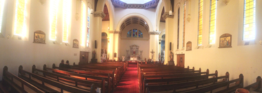
In 1872 membes of the Jesuits purchased land in Walpole Street. Three years later, on 14 Februrary 1875, Archbishop Gould laid a foundation stone for a school. By 1899 the land for the current church was purchased after mining speculator and Mt Lyell 'Copper King' James Crotty donated 3,000.00 pounds. The foundation stone was laid on 15 December 1918 by Archbishop Mannix. The cost of constructing the domed church was 15,000.00 pounds. A Fincham and Sons organ was installed in 1927, and refurbished in 1977. NEW PRESBYTERY AT KEW. Plans have been prepared by Mr. R. Harper, architect and builder, for the erection of a new presbytery for the Rev. P. Rafferty, adjoining the Sacred Heart Church, Cotham-road, Kew. The new building, which will be in brick and of two stories, will be behind the present priests' residence, which will continue to be used until the new presbytery is completed. The cost will be £6000, and the work will be begun almost immediately. The old presbytery was purchased many years ago by the late Rev. Fr. P. O'Donohue from the late Mr. Smart for £3000, and the full amount of the purchase money was donated by the late Mr. James Crotty. At different times additions were made to the building, but the small rooms made it altogether unsuitable as a residence for three priests, and made remodelling impracticable. The new presbytery will be in keeping with the Church of the Sacred Heart and the surroundings on the elevated site. At one time the old Sacred Heart Church was in Walpole-street, Kew. (The Advocate, 09 December 1937) The whole of the estate of the late Jas. Crotty has now been realised ex cepting 4000 shares in the Mount Lyell Company and a small parcel of general mining shares. All the debts and legacies, including £10,000 to St. Patrick's and £3300 to the testator's parish church at Kew, and also probate duty, have been paid. On present values the Mount Lyell shares. are worth a total of £37,000, and at the present rate of dividends the return represents an income of about £2000 per annum. Over and above this there is a sum of between £20,000 and £30,000 available for investment, and this, together with the dividends brings the income of the estate up to about £3000 per annum. A sum of £1100 per annum will be absorbed in annuities under the terms of the will. Whatever amount is realised beyond the sum necessary to pay the annuities goes to Archbishop Carr for the church and charitable purposes until the death of the last annuitant, when the resi duary estate will be divided between the Little Sisters of the Poor (North cote) and St. Joseph's Home (Surrey Hills). (Launceston Examiner, 18 July 1899) Sunday last being the anniversary of tire opening of the Sacred Heart Church, Kew, the pastor, Rev. Fr. Manly, made a special appeal at the various Masses. The beautiful design for marble altar for the Lady Chapel, which is on view in the vestibule, continues to attract attention. The Children of Mary Sodality have kindly undertaken to provide it, and the president, Miss Frances O'Sulliv!an, 43 Rideway-avenue, Kew, will be pleased to receive and acknow r ledge subscriptions from clients of Our Lady. They may also be placed in box near Lady Altar. (The Advocate, 06 December 1923)Panorama of the interior of Sacred Heart Catholic Church Kew. sacred heart, kew, catholic church -
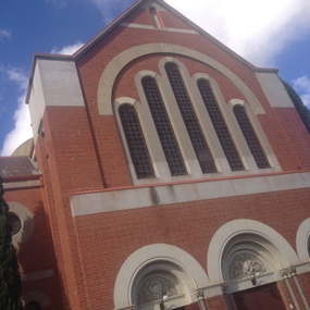 Ballarat Heritage Services
Photograph, Clare Gervasoni, Exterior of Sacred Heart Kew, 01/03/2015
In 1872 membes of the Jesuits purchased land in Walpole Street. Three years later, on 14 Februrary 1875, Archbishop Gould laid a foundation stone for a school. By 1899 the land for the current church was purchased after mining speculator and Mt Lyell 'Copper King' James Crotty donated 3,000.00 pounds. The foundation stone was laid on 15 December 1918 by Archbishop Mannix. The cost of constructing the domed church was 15,000.00 pounds. A Fincham and Sons organ was installed in 1927, and refurbished in 1977. NEW PRESBYTERY AT KEW. Plans have been prepared by Mr. R. Harper, architect and builder, for the erection of a new presbytery for the Rev. P. Rafferty, adjoining the Sacred Heart Church, Cotham-road, Kew. The new building, which will be in brick and of two stories, will be behind the present priests' residence, which will continue to be used until the new presbytery is completed. The cost will be £6000, and the work will be begun almost immediately. The old presbytery was purchased many years ago by the late Rev. Fr. P. O'Donohue from the late Mr. Smart for £3000, and the full amount of the purchase money was donated by the late Mr. James Crotty. At different times additions were made to the building, but the small rooms made it altogether unsuitable as a residence for three priests, and made remodelling impracticable. The new presbytery will be in keeping with the Church of the Sacred Heart and the surroundings on the elevated site. At one time the old Sacred Heart Church was in Walpole-street, Kew. (The Advocate, 09 December 1937) The whole of the estate of the late Jas. Crotty has now been realised ex cepting 4000 shares in the Mount Lyell Company and a small parcel of general mining shares. All the debts and legacies, including £10,000 to St. Patrick's and £3300 to the testator's parish church at Kew, and also probate duty, have been paid. On present values the Mount Lyell shares. are worth a total of £37,000, and at the present rate of dividends the return represents an income of about £2000 per annum. Over and above this there is a sum of between £20,000 and £30,000 available for investment, and this, together with the dividends brings the income of the estate up to about £3000 per annum. A sum of £1100 per annum will be absorbed in annuities under the terms of the will. Whatever amount is realised beyond the sum necessary to pay the annuities goes to Archbishop Carr for the church and charitable purposes until the death of the last annuitant, when the resi duary estate will be divided between the Little Sisters of the Poor (North cote) and St. Joseph's Home (Surrey Hills). (Launceston Examiner, 18 July 1899) Sunday last being the anniversary of tire opening of the Sacred Heart Church, Kew, the pastor, Rev. Fr. Manly, made a special appeal at the various Masses. The beautiful design for marble altar for the Lady Chapel, which is on view in the vestibule, continues to attract attention. The Children of Mary Sodality have kindly undertaken to provide it, and the president, Miss Frances O'Sulliv!an, 43 Rideway-avenue, Kew, will be pleased to receive and acknow r ledge subscriptions from clients of Our Lady. They may also be placed in box near Lady Altar. (The Advocate, 06 December 1923)Exterior of Sacred Heart Catholic Church Kew. sacred heart, kew, catholic church -
 The Beechworth Burke Museum
Photograph, c1930
Taken on 25 October 1930, various houses with the Hume Dam under construction are depicted in the background. The construction of the Hume Dam took place from 1919 to 1936. At the time of construction, it was the second largest dam in the world. It was also one of the earliest civil projects developed after the Federation. Some of the Dam workers consisted of World War I veterans. Dam workers often settled their families in Mitta Junction Village and Wodonga. Archaeological surveys were completed by Austral Archaeology, which was done when the Department of Land & Water Conservation was doing work to improve Hume Dam. The archaeological report that came out of the survey recommended three sites of interest where archaeological excavation should be done: Camp Ganger’s Quarters, Stableman’s Quarters, and the Industrial Dump. The excavation uncovered artefacts. Mitta Mitta: Mitta Mitta is situated between Mount Welcome and Mount Misery. It is named after the river that explorers Hume and Hovell discovered in 1824. The town would eventually become a huge gold mining town. Mitta Mitta is called Midamodunga by the local Indigenous peoples Wodonga: Wodonga is situated on the Murray River and is part of North East Victoria. Hume and Hovell: Hamilton Hume (1979-1873) and William Hilton Hovell (1786-1875). W. H. Hovell was born in Norfolk England and Hume was born in Parramatta, New South Wales Hovell and Hume undertook an exploration journey in 1824 and thought they discovered a river, which turned out to be the Murray River. They returned home in 1825, but returned to the area in 1826 and discovered coal in the area. This photo is historically significant as it shows the Hume Dam under construction in 1930. The Dam was named after Hamilton Hume, who is an important historical figure for this area as he helped discover the area where resources were found.Sepia rectangular photograph printed unmountedReverse: 84-19-5 / 1997.3185/ Values & spillway. / When completed the wall / will be as high as the / scaffolding. [featuring trademark: kodak print]construction, houses, veterans, mitta junction village, hume dam, world war i, federation, wodonga, archaeological survey, excavation, austral archaeology, department of land & water conservation, camp ganger's quarter's, stableman's quarters, industrial dump, artefacts, mitta mitta, mount welcome, mount misery, murray river, hamilton hume, william hilton hovell, hume and hovell expedition -
 The Beechworth Burke Museum
Photograph, c1930
Taken on 25 October 1930, various houses with the Hume Dam under construction are depicted in the background. The construction of the Hume Dam took place from 1919 to 1936. At the time of construction, it was the second largest dam in the world. It was also one of the earliest civil projects developed after the Federation. Some of the Dam workers consisted of World War I veterans. Dam workers often settled their families in Mitta Junction Village and Wodonga. Archaeological surveys were completed by Austral Archaeology, which was done when the Department of Land & Water Conservation was doing work to improve Hume Dam. The archaeological report that came out of the survey recommended three sites of interest where archaeological excavation should be done: Camp Ganger’s Quarters, Stableman’s Quarters, and the Industrial Dump. The excavation uncovered artefacts. Mitta Mitta: Mitta Mitta is situated between Mount Welcome and Mount Misery. It is named after the river that explorers Hume and Hovell discovered in 1824. The town would eventually become a huge gold mining town. Mitta Mitta is called Midamodunga by the local Indigenous peoples Wodonga: Wodonga is situated on the Murray River and is part of North East Victoria. Hume and Hovell: Hamilton Hume (1979-1873) and William Hilton Hovell (1786-1875). W. H. Hovell was born in Norfolk England and Hume was born in Parramatta, New South Wales Hovell and Hume undertook an exploration journey in 1824 and thought they discovered a river, which turned out to be the Murray River. They returned home in 1825, but returned to the area in 1826 and discovered coal in the area.This photo is historically significant as it shows the Hume Dam under construction in 1930. The Dam was named after Hamilton Hume, who is an important historical figure for this area as he helped discover the area where resources were found.Sepia rectangular photograph printed unmountedReverse: 84-19-2/ 1997.3188/ These are the four / release valves they are / not always open (illegible) this / when closed the water flows / over the spillway. [featuring trademark: kodak print] photograph number: 354construction, houses, veterans, mitta junction village, hume dam, world war i, federation, wodonga, archaeological survey, excavation, austral archaeology, department of land & water conservation, camp ganger's quarter's, stableman's quarters, industrial dump, artefacts, mitta mitta, mount welcome, mount misery, murray river, hamilton hume, william hilton hovell, hume and hovell expedition -
 The Beechworth Burke Museum
Photograph, 25 October 1930
Taken on 25 October 1930, various houses with the Hume Dam under construction are depicted in the background. The construction of the Hume Dam took place from 1919 to 1936. At the time of construction, it was the second largest dam in the world. It was also one of the earliest civil projects developed after the Federation. Some of the Dam workers consisted of World War I veterans. Dam workers often settled their families in Mitta Junction Village and Wodonga. Archaeological surveys were completed by Austral Archaeology, which was done when the Department of Land & Water Conservation was doing work to improve Hume Dam. The archaeological report that came out of the survey recommended three sites of interest where archaeological excavation should be done: Camp Ganger’s Quarters, Stableman’s Quarters, and the Industrial Dump. The excavation uncovered artefacts. Mitta Mitta: Mitta Mitta is situated between Mount Welcome and Mount Misery. It is named after the river that explorers Hume and Hovell discovered in 1824. The town would eventually become a huge gold mining town. Mitta Mitta is called Midamodunga by the local Indigenous peoples Wodonga: Wodonga is situated on the Murray River and is part of North East Victoria. Hume and Hovell: Hamilton Hume (1979-1873) and William Hilton Hovell (1786-1875). W. H. Hovell was born in Norfolk England and Hume was born in Parramatta, New South Wales Hovell and Hume undertook an exploration journey in 1824 and thought they discovered a river, which turned out to be the Murray River. They returned home in 1825, but returned to the area in 1826 and discovered coal in the area.This photo is historically significant as it shows the Hume Dam under construction in 1930. The Dam was named after Hamilton Hume, who is an important historical figure for this area as he helped discover the area where resources were found.Sepia rectangular photograph printed unmountedReverse: 84-19-6/ 1997.3187/ The spillway [featuring trademark: kodak print] construction, houses, veterans, mitta junction village, hume dam, world war i, federation, wodonga, archaeological survey, excavation, austral archaeology, department of land & water conservation, camp ganger's quarter's, stableman's quarters, industrial dump, artefacts, mitta mitta, mount welcome, mount misery, murray river, hamilton hume, william hilton hovell, hume and hovell expedition -
 The Beechworth Burke Museum
Photograph, 25 October 1930
Taken on 25 October 1930, various houses with the Hume Dam under construction are depicted in the background. The construction of the Hume Dam took place from 1919 to 1936. At the time of construction, it was the second largest dam in the world. It was also one of the earliest civil projects developed after the Federation. Some of the Dam workers consisted of World War I veterans. Dam workers often settled their families in Mitta Junction Village and Wodonga. Archaeological surveys were completed by Austral Archaeology, which was done when the Department of Land & Water Conservation was doing work to improve Hume Dam. The archaeological report that came out of the survey recommended three sites of interest where archaeological excavation should be done: Camp Ganger’s Quarters, Stableman’s Quarters, and the Industrial Dump. The excavation uncovered artefacts. Mitta Mitta: Mitta Mitta is situated between Mount Welcome and Mount Misery. It is named after the river that explorers Hume and Hovell discovered in 1824. The town would eventually become a huge gold mining town. Mitta Mitta is called Midamodunga by the local Indigenous peoples Wodonga: Wodonga is situated on the Murray River and is part of North East Victoria. Hume and Hovell: Hamilton Hume (1979-1873) and William Hilton Hovell (1786-1875). W. H. Hovell was born in Norfolk England and Hume was born in Parramatta, New South Wales Hovell and Hume undertook an exploration journey in 1824 and thought they discovered a river, which turned out to be the Murray River. They returned home in 1825, but returned to the area in 1826 and discovered coal in the area.This photo is historically significant as it shows the Hume Dam under construction in 1930. The Dam was named after Hamilton Hume, who is an important historical figure for this area as he helped discover the area where resources were found.Black and white rectangular photograph printer unmountedReverse: 84-20-1/ 1997.3147construction, houses, veterans, mitta junction village, hume dam, world war i, federation, wodonga, archaeological survey, excavation, austral archaeology, department of land & water conservation, camp ganger's quarter's, stableman's quarters, industrial dump, artefacts, mitta mitta, mount welcome, mount misery, murray river, hamilton hume, william hilton hovell, hume and hovell expedition -
 The Beechworth Burke Museum
Photograph, 25 October 1930
Taken on 25 October 1930, various houses with the Hume Dam under construction are depicted in the background. The construction of the Hume Dam took place from 1919 to 1936. At the time of construction, it was the second largest dam in the world. It was also one of the earliest civil projects developed after the Federation. Some of the Dam workers consisted of World War I veterans. Dam workers often settled their families in Mitta Junction Village and Wodonga. Archaeological surveys were completed by Austral Archaeology, which was done when the Department of Land & Water Conservation was doing work to improve Hume Dam. The archaeological report that came out of the survey recommended three sites of interest where archaeological excavation should be done: Camp Ganger’s Quarters, Stableman’s Quarters, and the Industrial Dump. The excavation uncovered artefacts. Mitta Mitta: Mitta Mitta is situated between Mount Welcome and Mount Misery. It is named after the river that explorers Hume and Hovell discovered in 1824. The town would eventually become a huge gold mining town. Mitta Mitta is called Midamodunga by the local Indigenous peoples Wodonga: Wodonga is situated on the Murray River and is part of North East Victoria. Hume and Hovell: Hamilton Hume (1979-1873) and William Hilton Hovell (1786-1875). W. H. Hovell was born in Norfolk England and Hume was born in Parramatta, New South Wales Hovell and Hume undertook an exploration journey in 1824 and thought they discovered a river, which turned out to be the Murray River. They returned home in 1825, but returned to the area in 1826 and discovered coal in the area. This photo is historically significant as it shows the Hume Dam under construction in 1930. The Dam was named after Hamilton Hume, who is an important historical figure for this area as he helped discover the area where resources were found. Black and white rectangular photograph printer unmountedReverse: 1997.3145/ 84-20-2construction, houses, veterans, mitta junction village, hume dam, world war i, federation, wodonga, archaeological survey, excavation, austral archaeology, department of land & water conservation, camp ganger's quarter's, stableman's quarters, industrial dump, artefacts, mitta mitta, mount welcome, mount misery, murray river, hamilton hume, william hilton hovell, hume and hovell expedition -
 Bendigo Military Museum
Photograph - Removal of Sequoia Californian Redwood Tree - Army Survey Regiment, Fortuna, Bendigo, 1994
These nine photographs of contractors felling a sequoia Californian redwood tree was taken at the Army Survey Regiment, Fortuna, Bendigo on the 16th of September 1994. Although 23 photos were taken at the time, 14 were not scanned due to their similarity to the nine featured photos. Two sequoia Californian redwood trees were planted at the front entrance of Fortuna Villa in the early days of gold mining magnate George Lansell’s occupation in the 1870’s. They were of immense proportion and much admired during the Lansell era and RA Svy’s occupation from 1942 to 1996. In these early days of Army occupation, the trees were lopped due to concerns of their size and proximity to the Villa. The felling of the tree in 1994 was considered unsafe due to perceptions of disease. These perceptions were upsetting to staff, as some believed that although there were a few dead branches, the tree was OK. As the tree had a noticeable lean, measurements were taken indicating the tree was stable. A sequoia sapling was eventually planted as a replacement to the diseased tree. It was decided to mill and store the timber of the felled tree on-site due to its historical significance. Although future uses were not determined at the time, the timber was eventually used to construct display cabinets and souvenir pens. When Defence decided to relocate geospatial production to a new facility in Junortoun an outer suburb of Bendigo in 2008, the sequoia timber was used as a beautiful feature in the front foyer as well as several feature walls within the building, providing a historical connection Fortuna Villa.This is a set of nine photographs of contractors felling a Sequoia (Californian redwood) tree at the Army Survey Regiment, Fortuna, Bendigo on the 16th of September 1994. The colour photographs were printed on photographic paper and are part of the Army Survey Regiment’s Collection. The photographs were scanned at 300 dpi. .1) - Photo, colour, 1994, Felling of sequoia Californian redwood tree. .2) - Photo, colour, 1994, Felling of sequoia Californian redwood tree. Neil Morgan (ground maintenance) is hugging the tree. .3) - Photo, colour, 1994, Felling of sequoia Californian redwood tree. .4) to .8) - Photo, colour, 1994, Felling of sequoia Californian redwood tree. .9) - Photo, colour, 1994, background on left - WO2 Bob Garritty, foreground L to R: Geoff (ground maintenance), unidentified, Neil Morgan (ground maintenance)..1P to .9P – No personnel are identified.royal australian survey corps, rasvy, army survey regiment, army svy regt, fortuna, asr -
 Eltham District Historical Society Inc
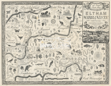
Map, George W. Bell, A Visitor's Guide Map; ELTHAM, WARRANDYTE and Environs, c.1969
Commissioned by George W. Bell, designed by Anthony Harvey. An old gold mining and wine growing district eighteen miles from Melbourne, now notable for its arts, crafts, good food and historic buildings. On the reverse side (of one copy only) is printed in 8 panels (3 half-folds) advertising for Montsalvat, Eltham; Setel Downs Coffee Kitchen Art Gallery, Kangaroo Ground; Country Art Store, Eltham; Alfred's Homestead, Warrandyte; Neville F Emmerson Estate Agent, Lower Plenty; Eltham Crafts. Monstsalvat, Eltham; Tantoon native plants and culinary herbs, Eltham; Flavour of Eltham, Shillinglaw Coattage Preservation Society; The Eltham Barrel; Potters Cottage, Warrandyte. In addition is provided by cateogory listing: POTTERY AND CRAFTS Country Art Store, Eltham Diamond Creek Handicrafts, Diamond Creek Eltham Crafts, Eltham John Mills, Eltham Potters Cottage, Warrandyte Setel Downs, Kangaroo Ground The Claypot, Warrandyte Warrandyte Quarries and Pottery, Warrandyte GOOD FOOD AND DRINK Alfred's Homestead, Warrandyte Geranium Parlour,. Research Inglenook, Warrandyte La Ronde, Eltham The Barrel, Research The Potters Restaurant, Warrandyte Setel Downs, Kangaroo Ground GALLERIES Hassall's Gallery, Research Lodge Gallery, Warrandyte The Bird Gallery, Eltham Royalat Gallery, Panton Hill PLANTYS, TREES AND SHRUBS Danson's Gardens, Research Dean's Orchids & Dahlias, Templestowe Diamond Vlley Trees & Shrubs, Warrandyte Jum Jum, Diamond Creek Parson's, Research Tantoon, Eltham Warran Glen, Warrandyte44..8 x 57.5 cm (Two copies) On the reverse side (of one copy only) is printed in 8 panels (3 half-folds) advertisingeltham, warrandyte, map, country art store, diamond creek handicrafts, eltham crafts, john mills, potters cottage, setel downs, the claypot, warrandyte quarries and pottery, alfred's homestead, geranium parlour, inglenook, la ronde, the barrel, the potters restaurant, hassall's gallery, lodge gallery, the bird gallery, royalat gallery, danson's gardens, dean's orchids & dahlias, diamond vlley trees & shrubs, jum jum, parson's, tantoon, warran glen, advertising, eltham barrel