Showing 2554 items
matching historic photographs
-
 Ringwood and District Historical Society
Pamphlet, Maroondah City Council, Ringwood Central - Historic Walk, c. 2000
Produced by Maroondah City Council, sponsored by the Maroondah Tourism Advisory Board from notes by courtesy of the Ringwood Archives.Ringwood Central - Historic Walk. White bifold pamphlet with photographs (12) and map. Explanatory text; 2 copies. -
 Ringwood and District Historical Society
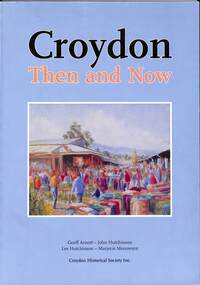
Book, Croydon Then and Now, 2012
Historic summary of Croydon comprised largely of early and contemporary photographs - Geoff Arnott, John Hutchinson, Les Hutchinson, Marjorie Meeuwsen, Croydon Historical Society Inc.Foreword by Cr. Les Willmott, J.P. - last mayor of the former City of Croydon. Acknowledgments: In the production of any book, many people play a part, be it financially or the giving of time with their knowledge and expertise in specialised areas, which concludes with a quality production - a book that is attractive, informative and accurate. We believe this book fits the description handsomely, and should bring joy and pleasant memories to many former and current residents of Croydon. To people who don't know very much about Croydon, this book will most certainly enlighten them. This has been a team effort, with many people playing important roles. With all this in mind, we would like to thank the following: The Maroondah City Council The Australian National Library Department of Families, Housing, Community Services and Indigenous Affairs Hutchinson Legal of Ringwood Sue Pitt, Alan Bennett and staff of the Croydon Library David and Ron Jewell Andrew Potts Adrian Arnott Elsie Bolwell Lyn Lynch Nick Anchen Cr Les Wilmott JP The Neville Family Bounty Print Dawn Gubb Photo courtesy of Leader Newspaper Press on pages 87, 90 and 113 -
 Ringwood and District Historical Society
Booklet, St Paul's Anglican Church Ringwood Centenary Souvenir History, 1979
Historic summary concentrating on four moves of St Paul's Anglican Church in Ringwood from 1879 to 1979 including photographs of each location - Mount Dandenong Road, Pratt Street, Ringwood Street, and Warrandyte Road. Includes list of vicars from 1905 to 1979.Introduction by Rev. Bill Potter, Vicar. Compiled by Stella Badger Design, Charles Miller -
 Bendigo Military Museum
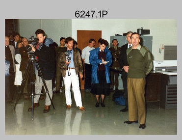
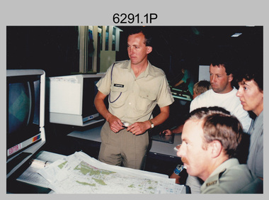
Photograph - Speedmaster Printing Press Media Announcement and Army Survey Regiment Open Day, Fortuna Villa, Bendigo, 1990
The first photograph was probably taken at a media event announcing the introduction of the Heidelberg Speedmaster printing press in late 1990. LTCOL Rene van den Tol was the CO of the Army Survey Regiment from 1989 to 1991. Partly obscured behind the CO was Mr Bruce Reid, who was the newly elected federal member for Bendigo. The media event was held in Wayzgoose Hall, Lithographic Squadron’s new purpose-built building constructed to house the Speedmaster 102 printing press. The remaining 29 photographs were taken at an Army Survey Regiment Open Day at Fortuna Villa, Bendigo on the 24th of February 1990. This occasion was one of several events held to commemorate the 75th anniversary of the formation of the Royal Australian Survey Corps. Although historical tours of Fortuna occurred on a regular basis, this was the first technical open day since 1972. The Royal Australian Survey Corps recognised that an Open Day was the best way for the local community in Bendigo to gain an insight into the unit’s important role as Defence’s map production agency, its technical equipment, and its economic importance to Bendigo. It also gave them an opportunity to tour through historic Fortuna Villa. This occasion is covered in more detail in page 143 of Valerie Lovejoy’s book 'Mapmakers of Fortuna – A history of the Army Survey Regiment’ ISBN: 0-646-42120-4. Refer to Item 6291.6P for more photos of the Open Day.The first photograph was probably taken at a media event announcing the introduction of the Speedmaster printing press at Army Survey Regiment Fortuna Villa, Bendigo in late 1990. The remaining 29 photographs were taken at an Open Day on the 24th of February 1990. The colour and black & white photographs were printed on photographic paper and are part of the Army Survey Regiment’s Collection. The photographs were scanned at 300 dpi. .1) - Photo, colour, 1990. L to R: Unidentified civilian visitor/media, SSGT Ian Nichols, unidentified (x2), SGT Dale Hudson (white top), unidentified (x2), MAJ John South, MHR Mr. Bruce Reid, CO LTCOL Rene van den Tol. .2) - Photo, black & white, 1990. WO1 Gary Warnest, civilian visitors. .3) to .4) - Photo, colour, 1990. WO2 Adrian 'Charlie' Creedy, civilian visitors. .5) - Photo, colour, 1990. Civilian visitors. .6) to .7) - Photo, colour, 1990. Civilian visitors, CPL Peter Peterson. .8) - Photo, black & white, 1990. L to R: LCPL Sandy Winn, civilian visitor. .9) - Photo, colour, 1990. L to R: CPL Steve McGuiness, civilian visitors. .10) - Photo, black & white, 1990. Display of digital storage media. .11) - Photo, colour, 1990. L to R: Mr Pat Thwaites outlining utilisation of satellite imagery to civilian visitors. .12) - Photo, colour, 1990. MAJ Peter Clarke with civilian visitors. .13) - Photo, colour, 1990. Unidentified technician with civilian visitors. .14) - Photo, colour, 1990. SGT Barry Hogan with civilian visitors. .15) - Photo, colour, 1990. SPR Ian Baldwin with civilian visitors. .16) - Photo, black & white, 1990. SPR Ian Baldwin with civilian visitors. .17) - Photo, black & white, 1990. SGT Sherri (Dally) Burke with civilian visitors. .18) - Photo, colour, 1990. L to R: SPR Jeanette (Lane) Dury-Lane, CPL Diane (Thomas) Soutar with civilian visitors. .19) - Photo, colour, 1990. L to R: unidentified technician, CPL Col McInnes, LCPL Charmian McKean. .20) - Photo, black & white, 1990. CAPT Peter Parkes. .21) - Photo, black & white, 1990. L to R: LCPL Janet Murray, MAJ Bob Coote, SPR Gary Lord. .22) - Photo, black & white, 1990. LT Marty Lyons with civilian visitors. .23) - Photo, colour, 1990. LT Marty Lyons with civilian visitors. .24) - Photo, black & white, 1990. SSGT Ian Nichols, CPL Dale Hudson, Planeta printing press, with civilian visitors. .25) - Photo, colour, 1990. Cars parked in Chum Street outside entrance to Fortuna Villa. .26) - Photo, colour, 1990. Civilian visitors near Fortuna Villa’s front door viewed from back gate. .27) - Photo, colour, 1990. Civilian visitors enjoying views of the garden from Fortuna Villa’s rooftop. .28) - Photo, colour, 1990. Civilian visitors enjoying views of the garden from Fortuna Villa’s verandah and rooftop. .29) - Photo, colour, 1990. Civilian visitors enjoying BBQ cooked by CPL Paul Baker and SPR Shona Hastie outside Lithographic Squadron. .30) - Photo, colour, 1990. BBQ cooked by CPL Paul Baker outside Lithographic Squadron..1P to .30P – no annotationsroyal australian survey corps, rasvy, army survey regiment, army svy regt, fortuna, asr, printing, litho -
 Bendigo Military Museum
Photograph - Army Survey Regiment Open Day at Fortuna, Bendigo, 1990
These six photographs were taken at an Army Survey Regiment Open Day at Fortuna Villa, Bendigo on the 24th of February 1990. This occasion was one of several events held to commemorate the 75th anniversary of the formation of the Royal Australian Survey Corps. Although historical tours of Fortuna occurred on a regular basis, this was the first technical open day since 1972. The Royal Australian Survey Corps recognised that an Open Day was the best way for the local community in Bendigo to gain an insight into the unit’s important role as Defence’s map production agency, its technical equipment, and its economic importance to Bendigo. It also gave them an opportunity to tour through historic Fortuna Villa. This occasion is covered in more detail in page 143 of Valerie Lovejoy’s book 'Mapmakers of Fortuna – A history of the Army Survey Regiment’ ISBN: 0-646-42120-4. Refer to Item 6247.30P for more photos of the Open Day. These six photographs were taken at an Army Survey Regiment Open Day at Fortuna, Bendigo on the 24th of February 1990. The colour and black & white photographs were printed on photographic paper and are part of the Army Survey Regiment’s Collection. The photographs were scanned at 300 dpi. .1) - Photo, colour, 1990, AUTOMAP 2 L to R: SSGT Graham Johnston, SPR Grant Davis, civilian visitors. .2) - Photo, black & white, 1990. Photo Troop, WO2 Keith Fenton RE. UK Exchange. .3) - Photo, black & white, 1990. Aerotrig, SGT Bruce Hammond, civilian visitors. .4) - Photo, black & white, 1990. AUTOMAP 2 L to R: SPR Peter Smyth, LT Steve Hledik, SGT Martin Evans, MAJ Neil Taylor, Civilian visitors. .5) - black & white, Orthophoto Mapping, L to R: civilian visitors, SSGT Peter Imeson, civilian visitor, SGT Bob Garritty. .6) - black & white, Print Troop L to R: civilian visitors, SSGT Ian Nichols, CPL John ‘Flash’ Anderson..1P to .6P – there are no annotations.royal australian survey corps, army svy regt, rasvy, army survey regiment, fortuna, asr -
 Bendigo Military Museum
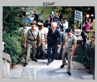
Photograph - Prime Minister’s Visit to the Army Survey Regiment, Fortuna, Bendigo, 1990
This photograph of Prime Minister Hon RJ Hawke’s visit to the Army Survey Regiment was taken at Fortuna, Bendigo in March 1990. This occasion was one of several events held to commemorate the 75th anniversary of the formation of the Royal Australian Survey Corps. The one-hour visit was a rare opportunity for RA Svy to demonstrate to its Prime Minister the unit’s important role as Defence’s map production agency, its technical equipment, and its economic importance to Bendigo. It was also an opportunity to take him through historic Fortuna Villa. This occasion is covered in more detail in page 143 of Valerie Lovejoy’s book 'Mapmakers of Fortuna – A history of the Army Survey Regiment’ ISBN: 0-646-42120-4. Refer to Item 6247.30P for more photos of the Open Day. This photograph of Prime Minister Hon RJ Hawke’s visit to the Army Survey Regiment was taken at Fortuna, Bendigo in March 1990. The colour photograph was printed on photographic paper and is part of the Army Survey Regiment’s Collection. The photograph was scanned at 300 dpi. .1) - Photo, colour, 1990, Prime Minister Hon. R.J. Hawke AC GCL entering the front steps of Fortuna Villa. L to R: unidentified officer, MAJ Duncan Burns, Bob Hawke, John Brumby AO (partially obscured), CO LTCOL Rene van den Tol.There are no annotations.royal australian survey corps, rasvy, army survey regiment, army svy regt, fortuna, asr -
 Warrnambool and District Historical Society Inc.
Souvenir - Photograph Wallet: Valentine’s Snapshots, Valentine Publishing Co. Pty. Ltd. Melb & Sydney. Printed Great Britain, Circa 1920's
This collection of photographs shows various scenes around Warrnambool and district such as street scapes, the Ozone Coffee Palace, Botanic Gardens, Beach scenes, Hopkins River and Proudfoots on the Hopkins. Valentines snapshots were done of many place world wide, and packaged in a convenient size to be posted.These cards have an historic and artistic significance and also provide the opportunity to be used in an interpretive way. Small, pale green, card folder with 24 photographs, 12 are gloss finish and 12 matt finish. The gloss photos have titles printed on reverse and matt cards have handwritten style titles.On folder: Valentine’s snapshots. Printed in Great Britain.warrnambool, valentine postcards, lava street, koroit street, liebig street, proudfoots, warrnambool botanic gardens, warrnambool beach -
 Warrnambool and District Historical Society Inc.
Book, Historic Places of South West Victoria
This is the third in a series of booklets produced by the Land Conservation Council in 1997 (176 pages). Booklets One and Two (1996) contained A Descriptive Report and Proposed Recommendations. The Final Recommendations include information on processes for protection of historic places, lists of significant places in the south-western region and aboriginal historic places. Attached inside the back cover are two maps showing the location of the significant places.This is a useful book as it lists the declared historic sites in the region and researchers will find the information helpful. This is a soft-cover book with a multi-coloured cover featuring a photograph of the Pioneers Memorial, Deep Lead. It has a red-coloured spine and back cover.Front Cover – Historic Places - Special Investigation - South-Western Victoria - Final Recommendations – Land Conservation Council Spine – Historic Places – South-Western Victoria – Final Recommendations – Land Conservation Council Back Cover – Historic Places, Final Rec., code used for retail sales warrnambool -
 Warrnambool and District Historical Society Inc.
Work on paper - Project, Proudfoot's Boat House, Late 20th century
Proudfoots’ Boathouse was built in 1885 by Thomas Proudfoot and has remained an important historic building in Warrnambool to this day. In the late 20th century the original buildings were lifted and renovated and a new building constructed in front. This material on Proudfoot’s boathouse will be of considerable use for researchers on the buildings, especially the detail on the 1990s renovations and additions.This is a Warrnambool Secondary College school assignment (Claire Isaac) about Proudfoot’s Boathouse in Warrnambool. There are twelve unnumbered typed papers on white paper (A4 size) and five loose newspaper cuttings. The typed pages are outlined in red. Included are black and white photographs (copies) and colour photographs.proudfoot’s boathouse, claire isaac -
 Kiewa Valley Historical Society
Photograph - Tawonga Valley 1937, 06/05/1937
... cattle properties and tobacco farms. Historic photograph ...Hume and Hovell discovered the area in 1824 and by the end of the 19th century the valley was transformed by logging, dairy and beef cattle properties and tobacco farms. Historic photograph of the Tawonga Valley as it appeared in May 1937Black and white photograph of Tawonga Valley looking towards Mt BeautyHandwritten on rear of photograph in pencil - Thursday May 6th, 1937. Tawonga Valleytawonga, kiewa valley -
 Kiewa Valley Historical Society
Photographs x 2 - Afternoon tea visit to Towong Hill
Towong Hill Homestead is a 110-year-old Federation style mansion situated on a rock outcrop, with views of about 260 degrees. It was built over 2 years by grazier Walter Mitchell from bricks made from local clay dug from the river bank, to be the family home for his new bride Winifred. They established their home in 1904. After the death of Walter in 1917, Winifred relocated her family, but the homestead remained in the families hands. In 1935, Thomas Mitchell (1906-1984) returned home to Australia, a successful Lawyer, and married city girl, Elyne Chauvel, and settled himself back at his childhood home, Towong Hill. Thomas was a world champion slalom skier, had been a prisoner of the Japanese at Changi, and was elected for the Country Party in 1946 and served as attorney-general in the McDonald government. His wife Elayne (1913-2002) is best remembered for her Silver Brumby series of novels for children. But Elyne also wrote a substantial number of non-fiction works about the Snowy Mountains. Photographs demonstrate local Kiewa Valley residents enjoying a community visit to the historic homestead at Towong Hill which holds significance to the early history of the area. Also demonstrates a pictorial history of social activities undertaken during this period2 black and white photographs mounted on buff card. Kiewa Valley residents attending afternoon tea at Towong HillHandwritten in black pen underneath photo - T.W.Mitchell Towong Hill. Afternoon Teat w mitchell, towong hill, kiewa valley -
 Kiewa Valley Historical Society
Photographs x 2- Khancoban Station and Comet the horse
In 1824, Hume and Hovell were the first Europeans to pass through the district and graziers soon followed, impressed by the abundance of fodder and water. The first cattle run in the area was settled in about 1838 in what was known as Swampy Plains. Later, this run became known as “Khancoban Station”. Khancoban lies in the heart of the high country and is home of Australia’s mountain cattlemen. This heritage is celebrated in Banjo Paterson’s epic poem, “The Man from Snowy River”. In 1962, Bruce and Jo Chisholm relocated from Bond Springs to Khancoban Station, which Bruce had acquired in 1959. Khancoban Hereford and thoroughbred stud progeny were keenly sought after whenever they were presented in the sale ring. Bruce imported a stallion, Comet, from England in 1964. Comet stood at Khancoban for 15 years and was the sire of numerous winners, including Cobbermine, Kelly's Eye, Boack and Starglow. Photographs demonstrate local Kiewa Valley residents enjoying a community visit to the historic homestead at Khancoban Station which holds significance to the early history of the area. Its heritage is celebrated in Banjo Paterson’s epic poem, “The Man from Snowy River”. Also demonstrates a pictorial history of social activities undertaken during this period Black and white photographs mounted on buff card 1. Kiewa Valley residents visiting Khancoban Station 2. Photo of thoroughbred horse Comet and handler at Khancoban Station1. Handwritten in black ink below photo- Khancoban Station. Mrs. Young, Mrs Van Der Weyde 2. Handwritten in black ink above photo- "Comet' at Khancobankiewa valley residents, clare roper -
 Kiewa Valley Historical Society
Photograph - Photographs x 13 - Cattlemen
... the many bushfires that have ravaged the area. The photographs ...11 of the 13 photos were taken by Tor Holth and used in his book "Cattlemen of the High Country" first published in 1980. Co writer was Jane Holth (Barnaby). Of the other two photos, one was taken by C. Roper (2 old gentlemen of the High Plains) and the other (Fred Roper, Tom Hollonds, Kyran Marum - early cattlemen) unknown photographer. The book tells the story of the lives of the mountain cattlemen of Victoria's high country, the harsh conditions and challenges they faced when they mustered their cattle before winter to bring them down to lower pastures. Huts were built of any materials available and were scattered about the high plains to provide shelter from the elements. Some are still standing despite the many bushfires that have ravaged the area.The photographs are of historic significance as they are of early pioneers in the cattle industry in the Kiewa Valley. The huts are of significant interest as they show different types of construction and materials as does the cattle yard at Bogong Jack's. All 13 photos are black and white and printed on photographic paper and are of varying size. 1.On the back, hand written in pencil - "Bogong Jacks hut on Fainter Spur". 2.15 in top right hand corner and 120% centre of photo and circled. 2.On the back a typewritten label cut out and fixed with sticky tape "45 b.&w. Cope Hut, known also as the Menzies of the high plains." Lower left corner is a handwritten label, written in red biro, COPE HUT (underlined) V circled and Journeys into History. 3. Top right hand corner '2.32(a) and across the back, written in pencil, 'Wallace's Hut 1976' and 'TOR HOLTH' in red biro on small sticker lower R corner. 4.2.32(c) in pencil top R corner. 'Wallaces Hut 1976' in pencil across back of photo. 5. '42.7a' in pencil top R corner. Written in pencil across back of photo 'Remains of the second Tawanga Hut.' 6. 'Jim Edmundson Mt. Beauty' handwritten in blue biro across back of photo. 7. '2.26' in pencil top R corner. 'Cattle yard at Bogong Jack's' handwritten in blue biro across back of photo. 8. 'Jim Edmondson of Edmondsons hut' written in pencil on back of photo. 9. 'Geoff Wallace Kergunyah' written in pencil on back of photo. 10.' Geoff Wallace Kergunyah' handwritten in pencil on back of photo. 11. 2.11 in pencil top R corner. 'Fred Roper & Jack Platt. Ph. C.Roper' handwritten in orange pen and under, in pencil, '2 old gentlemen of the High Plains.' 12. Written in black pen across back of photo 'Left to right Fred Roper, Tom Hollonds, Kyran Marum - early cattlemen' 13. Hand written on back of photo 'Sid Ryder' photos, cattlemen, high plains, huts -
 Warrnambool and District Historical Society Inc.
Card - Birthday Card, Warrnambool Congregational Church, 1910
This is a birthday card sent to Frederick King in 1910 on the occasion of his birthday. The greetings have been sent by the Warrnambool Congregational Church and Sunday School and the card includes the names of the church Pastor, and the children's church roll superintendent A Congregational Church was opened in Warrnambool at the corner of Liebig and Lava Streets in 1864. In 1940 a new church was built at the corner of Lava and Henna Streets and when the Congregational Church joined with the Methodist Church the building in Lava Street was sold to the Salvation Army in 1979. No information has been found on Frederick King.This card is of historic interest, showing the custom early in the 20th century of church Sunday Schools sending birthday greetings to its attendees.This is a sheet of cream-coloured paper showing a blue-toned photograph, a coloured sketch of two birds and a spray of flowers, printing and handwritingwarrnambool congregational church, frederick king -
 Warrnambool and District Historical Society Inc.
Calendar, L.T.Taylor, 1953
This item comes from the estate of Dorothy and Agnes Ardlie and contains a clear photograph of their family home, Aroona (19 Princess Street, Warrnambool). Dorothy Ardlie (1910-1993) and Agnes Ardlie (1915-1993) were the daughters of Arthur and Ethel Ardlie of Warrnambool, the granddaughters of the prominent Warrnambool lawyer, William Ardlie and his wife Mary and the great granddaughters of John and Mary Ardlie, pioneer settlers in Warrnambool. This calendar is of interest as it contains a photograph of Aroona, the early 20th century residence of Dorothy and Agnes Ardlie. The photograph is at least 54 years old and so has historic significance, especially for local researchers.This is a piece of lightweight cream-coloured cardboard with a calendar for the year 1954 printed in blue on the bottom half of the sheet and some blue decorative patterns around the calendar. The top half of the sheet has a black and white photograph of a house inserted in slots with a blue border around the photograph. The back of the sheet has the stamp of a business house and some handwriting in blue ink. Calendar for 1954 ‘Aroona’ 19 Princess Street Warrnambool Home of A.S. Ardlie Familyardlie family, history of warrnambool, dorothy and agnes ardlie -
 Warrnambool and District Historical Society Inc.
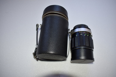
Camera Lens, 1 Soligor Lens. .2 case, C 1960
A manual detachable camera lens is used to focus the subject of which the photograph is to be taken . They have adjustments for distance and clarity while more complex ones can be fine tuned to a much greater degree. Photographs provide a invaluable resource from an historic perspective of past times people and events.This lens has significance as part of the continuum of camera development and use. It was owned by a local Warrnambool person who had a keen interest in photography..1 Black plastic and metal detachable camera lens with metal sections and graduated markings around the cylinder . There is a screw cap on one end where the lens is attached to the camera for use and the other end covering the lens itself has the brand name across the middle of cap. .2 Black leather cylindrical case with strap handle attached with silver metal hiinge and metal zipper towards the top section of the case. The lidded section has the brand name imprinted into the surface of the top..1 Lens made in Japan. Graduated scale from 1.5/5 to 20/50 .2 Soligor camera lens, warrnambool, history of warrnambool, soligor lens -
 Warrnambool and District Historical Society Inc.
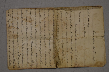
Letter, Peter Adam (writer of letter), 1907
This is an original letter written by Peter Adam to Edward Vidler in 1907. Peter Adam was a pioneer settler in the Warrnambool district and the letter records his life beginning with his arrival in 1854 and concluding with his connection with the Kinnear family who acquired the historic property of Allandale in 1906. The letter also refers to the sending of a photograph and a sum of money for the right to have the photograph included on Warrnambool’s Pioneer Honor Board. The recipient of the letter, Edward Vidler, was Secretary of the Warrnambool and District Progress league and Secretary of the Warrnambool Chamber of Commerce and Manufactures in 1907 and he proposed producing a Pioneer Honour Board as part of Warrnambool’s 60th anniversary celebrations. He contacted many of the pioneers or their families and asked for a photograph, a fee and a biography and had the Boadrd made. For many reasons, including financial ones, the Pioneer Honour Board was not seen by the Warrnambool public until the 1920s but today it is one of Warrnambool’s great treasures. This letter is original and is of the utmost importance as it gives personal information about the life of Peter Adam, a person on Warrnambool’s Pioneer Honour Board and it refers to the submission of a photograph for placement on the board. This is one of only two letters that we know of that refers to the sending of a photograph and the fee charged for its inclusion on the Pioneer Board. The recipient of the letter, Edward Vidler, is important in Warrnambool’s history as the person most responsible for producing the Warrnambool Pioneer Honour Board, one of Warrnambool’s historical treasures. This is a letter on a piece of paper folded to make four pages with three of these pages containing handwriting in black ink. The paper has been torn and mended with adhesive tape.peter adam, allansford, edward vidler, warrnambool, warrnambool’s pioneer honour board, history of warrnambool -
 Port of Echuca
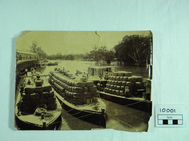
Photograph, P.S. Rodney with barges Horace & Nelson, c.1890
P.S Rodney with barges Horace & Nelson laden with wool bales bought into the Port to be unloaded onto rail trucks to go to markets in Melbourne. c.1890 Paddlesteamers travelled the river systems to bring wool from out- lying properties into the Port of Echuca to be transported by rail to Melbourne. This was prior to road & rail transport in the 1800'sOne of thousands of photos taken depicting the transportation of wool from out- lying properties to the rail head at Port of Echuca using paddlesteamers. P.S.Rodney alongside barges Horace & Nelson, tied to historic Echuca Wharf, with Pride of the Murray paddlesteamer & barge in back ground all vessels loaded with wool bales and crew resting on these. Riverbank lined with red gums. Handwritten in pen on lower left back corner "Rodney with barges Horace & Nelson c. 1890"farming, economy, p s rodney, port of echuca, wool bales, wharf, barges, horrace, nelson, paddlesteamer rodney, echuca -
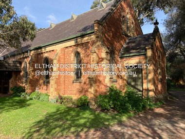 Eltham District Historical Society Inc
Photograph, Jim Connor, Eltham - Montmorency Uniting Church, 810 Main Rd, Eltham, 10 July 2023
Located on the corner of Main Road and John Street, the church first served the community as the Eltham Wesleyan Church since 1881. It became the Eltham Methodist Church in 1902, the year it united with the Primitive Methodists. Eltham Wesleyans first worshipped together in the home of William and Mary Crozier, on 24 acres bounded by Mount Pleasant Road and Pitt Street. From there they moved to a slab and bark hut in 1855 (this later served as the first school run by David Clark prior to the building of a new school in Dalton Street) and the members then built a chapel in 1858 on Lot 20, Henry Street (later to become the Rechabite Hall and Eltham Public Hall). The present church on John Street was designed by architects Crouch and Wilson in the Early English Gothic style with biochrome brick window frames, buttress heads and pinnacle. Church member George Stebbing built the church, the foundations were constructed with stone from the walls of the first Eltham State Primary School (No. 209) building which collapsed in 1874 and were purchased by Robert David Taylor. Stebbing was also responsible for building St Margaret’s Church and Shillinglaw Cottage. The Roll of Honour, which presently hangs in the church hall (which also doubles as the Opportunity Shop) lists 27 members of the congregation who served in the First World War, 11 of whom never returned. The red-brick Church Hall was opened in 1931 and in 1971 further additions linked the hall and church, including a foyer, vestry, meeting room and toilets reflecting the Eltham style of that time with its simplicity, extensive clear glass, reused baked clay-bricks from the 1881 church, heavy ceiling beams and compressed straw ceiling. On June 26, 1977, the church became part of the new Uniting Church in Australia consisting of the former Methodist and Congregational and most of the Presbyterian Churches. Following of declining numbers of worshippers, the church merged with the Montmorency Uniting Church on June 23, 1996. In 2023 the Uniting church approved a plan to renovate the church. It is understood that the historic church and the hall will be retained, and the building added in 1971 is to be demolished, to make way for a new purpose-built Opportunity shop. The proposed areas to be demolished include the current foyer, toilets, crèche, etc, including the area between the hall and the former RSL. Works are expected to commence mid to late July 2023. The Society was invited by a church member to take photographs of these areas to document them prior to demolition works commencing. Ref: “Nillumbik Now and Then” by Marguerite Marshall (2008)jim connor collection, 2023-07-10, eltham-montmorency uniting church, john street, methodist church, opportunity shop, uniting church, uniting church hall -
 Eltham District Historical Society Inc
Photograph - Aerial Photograph, Landata, Eltham North, Feb. 1956
Centred on present day 54 Kelway Crescent, Eltham North bounded by Glen Gully Road to north, Meruka Drive to south, Eltham College to east and Leach Street to west. Historic Aerial Imagery Source: Landata.vic.gov.au Aerial Photo Details: Project No :250 Project : MELBOURNE OUTER SUBURBS PROJECT Run : 17 Frame : 113 Date : 02/1956 Film Type : B/W Camera : EAG9 Flying Height : 10000 Scale : 12000 Film Number : 1176 GDA2020 : 37°42'16"S, 145°08'08"E MGA2020 : 335650, 5825336 (55) Melways : 21 G2 (ed. 42)aerial photo, 1956-02, eltham, eltham north, glen gully road, leach street, main road, melway 21g2, meruka drive, montmorency, neil webster collection -
 Eltham District Historical Society Inc
Photograph - Aerial Photograph, Landata, Montmorency, Feb. 1956
Centred on present day Tahlee Place Reserve and Sherbourne Preschool, Montmorency bounded by Progress Road to north, Withers Way to south, Main Road to east and Leach Street to west. Historic Aerial Imagery Source: Landata.vic.gov.au Aerial Photo Details: Project No :250 Project : MELBOURNE OUTER SUBURBS PROJECT Run : 17 Frame : 114 Date : 02/1956 Film Type : B/W Camera : EAG9 Flying Height : 10000 Scale : 12000 Film Number : 1176 GDA2020 : 37°42'50"S, 145°08'02"E MGA2020 : 335512, 5824286 (55) Melways : 21 F5 (ed. 42)aerial photo, 1956-02, neil webster collection, central park, eltham, leach street, main road, melway 21f5, montmorency, progress road, withers way, sherbourne preschool, tahlee place reserve -
 Eltham District Historical Society Inc
Photograph - Aerial Photograph, Landata, Montmorency, Feb. 1956
Centred on present day Grand Boulevard and Olympic Way, Montmorency bounded by Diamond Street to north, Old Eltham Road and Eltham Lower Park to south, Bible Street to east and Para Road to west. Historic Aerial Imagery Source: Landata.vic.gov.au Aerial Photo Details: Project No :250 Project : MELBOURNE OUTER SUBURBS PROJECT Run : 17 Frame : 115 Date : 02/1956 Film Type : B/W Camera : EAG9 Flying Height : 10000 Scale : 12000 Film Number : 1176 GDA2020 : 37°43'24"S, 145°07'55"E MGA2020 : 335375, 5823236 (55) Melways : 21 F7 (ed. 42)aerial photo, 1956-02, neil webster collection, eltham, main road, montmorency, bible street, diamond street, eltham lower park, grand boulevard, melway 21f7, old eltham road, olympic way, para road -
 Eltham District Historical Society Inc
Photograph - Aerial Photograph, Landata, Lower Plenty, Feb. 1956
Centred on present day 217 Old Eltham Road, Lower Plenty bounded by Pitt Street to north, Yarra River to south, Main Road to east and Bonds Road to west. Historic Aerial Imagery Source: Landata.vic.gov.au Aerial Photo Details: Project No :250 Project : MELBOURNE OUTER SUBURBS PROJECT Run : 17 Frame : 116 Date : 02/1956 Film Type : B/W Camera : EAG9 Flying Height : 10000 Scale : 12000 Film Number : 1176 GDA2020 : 37°43'58"S, 145°07'49"E MGA2020 : 335237, 5822186 (55) Melways : 21 E10 (ed. 42)aerial photo, 1956-02, neil webster collection, eltham, main road, bonds road, elham, lower plenty, melway 21e10, pitt street, yarra river -
 Eltham District Historical Society Inc
Photograph - Aerial Photograph, Landata, Eltham, Feb. 1956
Centred on present day Culla Hill and Petty's Orchard, Eltham bounded by Brougham Street and Mount Pleasant Road to north, Monckton Road, Templestowe to south, Reynolds Road to east and Eltham Lower Park and Hohnes Road to west. Historic Aerial Imagery Source: Landata.vic.gov.au Aerial Photo Details: Project No :250 Project : MELBOURNE OUTER SUBURBS PROJECT Run : 18 Frame : 92 Date : 02/1956 Film Type : B/W Camera : EAG9 Flying Height : 10000 Scale : 12000 Film Number : 1176 GDA2020 : 37°43'35"S, 145°09'31"E MGA2020 : 337735, 5822959 (55) Melways : 22 B8 (ed. 42)aerial photo, 1956-02, neil webster collection, eltham, brougham steet, culla hill, eltham lower park, hohnes road, melway 22b8, monckton road, mount pleasant road, petty's orchard, reynolds road, sweeneys lane, templestowe, yarra river -
 Eltham District Historical Society Inc
Photograph - Aerial Photograph, Landata, Eltham, Feb. 1956
Centred on present day Mount Plaeasant Road near Dalton Street, Eltham bounded by Luck Street to north, Eltham Lower Park to south, Reynolds Road to east and Central Park to west Historic Aerial Imagery Source: Landata.vic.gov.au Aerial Photo Details: Project No :250 Project : MELBOURNE OUTER SUBURBS PROJECT Run : 18 Frame : 93 Date : 02/1956 Film Type : B/W Camera : EAG9 Flying Height : 10000 Scale : 12000 Film Number : 1176 GDA2020 : 37°43'02"S, 145°09'38"E MGA2020 : 337871, 5823961 (55) Melways : 22 B6 (ed. 42)aerial photo, 1956-02, neil webster collection, eltham, central park, eltham lower park, luck street, melway 22b6, nyora road, reynolds road, dalton street, mount pleasant road -
 Eltham District Historical Society Inc
Photograph - Aerial Photograph, Landata, Eltham, Feb. 1956
Centred on present day Shalbury Avenue, Eltham bounded by Leane Drive and Parsons Road to north, Nyora Road to south, Reynolds Road to east and the Diamond Creek to west Historic Aerial Imagery Source: Landata.vic.gov.au Aerial Photo Details: Project No :250 Project : MELBOURNE OUTER SUBURBS PROJECT Run : 18 Frame : 95 Date : 02/1956 Film Type : B/W Camera : EAG9 Flying Height : 10000 Scale : 12000 Film Number : 1176 GDA2020 : 37°41'57"S, 145°09'51"E MGA2020 : 338145, 5825965 (55) Melways : 22 C1 (ed. 42)aerial photo, 1956-02, neil webster collection, eltham, diamond creek (creek), melway 22c1, nyora road, parsons road, reynolds road, shalbury avenue -
 Eltham District Historical Society Inc
Photograph - Aerial Photograph, Landata, Eltham, Vic, Feb. 1956
Centred on present day Parsons Avenue at Leane Drive near the Maroondah Aqueduct, Eltham bounded by Lorimer Road to north, Thompson Crescent and Norman Road to south, Bells Hill Road to east and Parsons Road to west Historic Aerial Imagery Source: Landata.vic.gov.au Aerial Photo Details: Project No :250 Project : MELBOURNE OUTER SUBURBS PROJECT Run : 19 Frame : 5 Date : 02/1956 Film Type : B/W Camera : EAG9 Flying Height : 10000 Scale : 12000 Film Number : 1176 GDA2020 : 37°42'04"S, 145°11'09"E MGA2020 : 340064, 5825786 (55) Melways : 22 H1 (ed. 42)aerial photo, 1956-02, neil webster collection, allendale road, bells hill road, eltham, leane drive, lorimer road, maroondah aqueduct, melway 22h1, norman road, parsons road, research (vic.), thompson crescent -
 Eltham District Historical Society Inc
Photograph - Aerial Photograph, Landata, Research, Vic, Feb. 1956
Centred on present day Thompson Crescent, Research bounded by Maroondah Aqueduct to north, Thompson Crescent and Nyora Road to south, Bells Hill Road to east and Eucalyptus Road to west Historic Aerial Imagery Source: Landata.vic.gov.au Aerial Photo Details: Project No :250 Project : MELBOURNE OUTER SUBURBS PROJECT Run : 19 Frame : 6 Date : 02/1956 Film Type : B/W Camera : EAG9 Flying Height : 10000 Scale : 12000 Film Number : 1176 GDA2020 : 37°42'38"S, 145°11'02"E MGA2020 : 339927, 5824736 (55) Melways : 22 H4 (ed. 42)aerial photo, 1956-02, neil webster collection, bells hill road, eltham, eucalyptus road, maroondah aqueduct, melway 22h4, nyora road, research (vic.), thompson crescent -
 Eltham District Historical Society Inc
Photograph - Aerial Photograph, Landata, Eltham, Vic, Apr. 1963
Centred on present day Zig Zag Road and Main Road, Eltham bounded by Maroondah Aqueduct to north, Thompson Crescent and Arthur Street to south, Parsons Road to east and Glen Park Road and Banks Road to west. Historic Aerial Imagery Source: Landata.vic.gov.au Aerial Photo Details: Project No :486 Project : MELBOURNE (1963) PROJECT Run : 5 Frame : 59 Date : 04/1963 Film Type : B/W Camera : RC8 Flying Height : 5100 Scale : 9600 Film Number : 1805 GDA2020 : 37°42'24"S, 145°08'52"E MGA2020 : 336716, 5825114 (55) Melways : 21 J3 (ed. 42)aerial photo, neil webster collection, eltham, 1963-04, arthur street, banks road, glen park road, maroondah aqueduct, melway 21j3, parsons road -
 Eltham District Historical Society Inc
Photograph - Aerial Photograph, Landata, Eltham, Vic, Apr. 1963
Centred on present day Floriston Grove, Eltham bounded by Maroondah Aqueduct to north, Thompson Crescent and Diosma Road to south, Research Shops to east and Glen Park Road and Park West Road to west. Historic Aerial Imagery Source: Landata.vic.gov.au Aerial Photo Details: Project No :486 Project : MELBOURNE (1963) PROJECT Run : 5 Frame : 60 Date : 04/1963 Film Type : B/W Camera : RC8 Flying Height : 5100 Scale : 9600 Film Number : 1805 GDA2020 : 37°42'24"S, 145°09'29"E MGA2020 : 337622, 5825128 (55) Melways : 22 B3 (ed. 42)aerial photo, neil webster collection, eltham, 1963-04, diosma road, floriston grove, maroondah aqueduct, melway 22b3, park west road, research (vic.), research shops