Showing 10880 items
matching land
-
 City of Moorabbin Historical Society (Operating the Box Cottage Museum)
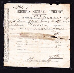
Certificate - Document, receipt burial 1890 Martha Jones, c1880
James Jones was the son of Philip Jones, a Chairmaker, and Ann Jones who settled in East Brighton after the sale of land c1852 in the area of the Henry Dendy Special Survey of 1841. Mary Ann Moore was the daughter of Thomas Moore, a Gardener, and Sarah Harris who also settled in Brighton c1852. James and Mary Ann Jones settled and raised their family in East Brighton now Bentleigh. Mr John Herron resided at 4 Vickery St Bentleigh until 1989. Sadly Martha Jones born 1888 died in 1890 and James Jones had to purchase a plot at Brighton General Cemetery for her burial. A further 2 children were interred in 1893 and 1900 then Mary Ann in 1903 and James in 1940James Jones and Mary Ann Moore were born in Brighton c1857 and c 1859 into pioneer market gardener families in the area of the Dendy Special Survey of 1841. They married in 1883 and raised their family in East Brighton, now Bentleigh. Sadly infectious diseases took the lives of many infants throughout the Colony of Victoria due to the poor state of water supply and sewerage disposal and locally the swamps of the Elster Creek were a constant breeding ground. Martha Jones born 1888 died 1890 and was interred in Brighton General Cemetery in a family plot purchased by her father James Jones. An original paper receipt No. 2844 for payment 22 January 1890 by James Jones to Brighton General Cemetery of 3 pounds 1 shilling for burial of Martha Jones aged approx. 2 years in a plot 4 feet x 8 feet. Fees include family grave at 2 pounds 2 shillings, Sinking to 7 feet at 14 shillings and Label 5 shillings .No. 2844( hand written) / BRIGHTON GENERAL CEMETERY / RECEIVED 22 January 18 90 / of Mr James Jones ( hand written ) the sum of £3. 1 being the / following charges in Wesleyan Portion No. / Compt. Name of deceased Martha Jones / Signed S Simmonds (handwritten) Secretary Along left side G.H Orford Printer “ Southern Cross Office” Bay St. Brighton melbourne, brighton, moorabbin, water supply, pioneers, bentleigh, dendy henry, market gardeners, early settlers, jones mary ann, wesleyan church, jones james, vaccination, typhoid, dendys special survey 1841, infectious diseases, elster creek, jones martha, brighton general cemetery, orford g h, printers, southern cross office, bay street brighton -
 City of Moorabbin Historical Society (Operating the Box Cottage Museum)
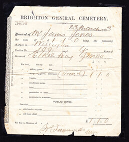
Certificate - Document, receipt Burial 1893 Ethel May Jones, c1890
James Jones was the son of Philip Jones, a Chairmaker, and Ann Jones who settled in East Brighton after the sale of land c1852 in the area of the Henry Dendy Special Survey of 1841. Mary Ann Moore was the daughter of Thomas Moore, a Gardener, and Sarah Harris who also settled in Brighton c1852. James and Mary Ann Jones settled and raised their family in East Brighton now Bentleigh. Mr John Herron resided at 4 Vickery St Bentleigh until 1989. Sadly Martha Jones born 1888 died in 1890 and James Jones had to purchase a plot at Brighton General Cemetery for her burial. Baby Ethel May was interred in 1893 and another baby in 1900 then Mary Ann in 1903 and James in 1940James Jones and Mary Ann Moore were born in Brighton c1857 and c 1859 into pioneer market gardener families in the area of the Dendy Special Survey of 1841. They married in 1883 and raised their family in East Brighton, now Bentleigh. Sadly infectious diseases took the lives of many infants throughout the Colony of Victoria due to the poor state of water supply and sewerage disposal and locally the swamps of the Elster Creek were a constant breeding ground. Martha Jones born 1888 died 1890 and was interred in Brighton General Cemetery in a family plot purchased by her father James Jones. In 1893 another daughter Ethel May died and was buried in the family plot. An original paper receipt No. 3454 for payment on 23 March 1893 by James Jones to Brighton General Cemetery of £1 . 1s For the burial of baby Ethel May Jones in a plot 4 feet x 8 feet, in the Wesleyan section portion 199 compartment G. Fee was for reopening the grave he had purchased in 1890 for the burial of his daughter Martha, aged 2 years . BRIGHTON GENERAL CEMETERY / 3454 ( stamped) / 23 March 1893 ( hand written ) / Received from Mr James Jones ( hand written ) / the sum of £1 . 1s being the following / charges in Wesleyan (hand written) / Portion No, 199 compt.G Name of / deceased Ethel May Jones ( handwritten) / for re-opening grave internment recent ( hand written) £1 . 1s / Signed S Simmonds ( ?manager) Along left side of receipt is printed SOUTHERN CROSS PRINT, BRIGHTON melbourne, brighton, moorabbin, water supply, pioneers, bentleigh, dendy henry, market gardeners, early settlers, jones mary ann, wesleyan church, jones james, vaccination, typhoid, dendys special survey 1841, infectious diseases, elster creek, jones martha, brighton general cemetery, orford g h, printers, southern cross office, bay street brighton, jones ethel may -
 St Kilda Historical Society
Ephemera - Invitation, 80th Anniversary Services, 1934
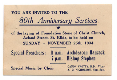
Invitation to services commemorating the 80th anniversary of the laying of the foundation stone of Christ Church, at 14 Acland Street St Kilda, on 25 November 1934. Christ Church was constructed in 1854-57 and designed in Decorated Gothic style by Albert Purchase & Charles Swyer. It was enlarged in 1874 and 1881 to the designs of Sydney W Smith. It is one of four main buildings constructed on land granted to the Church of England in 1855 and named Church Square. The other buildings are the bishop's residence, vicarage and parish hall. Heritage Victoria describes it as a 'rare and significant square in the history of town planning in Victoria which demonstrates the importance of the church to the community'. It is built from rarely used undressed random coursed sandstone from Point King Sorrento. White card, discoloured with aged, printed in dark blue on one side.christ church, acland street -
 Chiltern Athenaeum Trust
Domestic object, Unknown
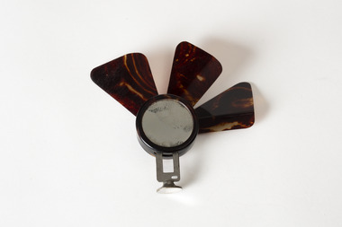
This object is part of the Wilfred Clarence Busse Collection. Wilfred Clarence Busse was born in Chiltern, Victoria in 1898. His family first arrived in this region during the gold rush era, purchasing a piece of land adjacent to the Murray River. The spectacular scenery and rich history of the area is said to have inspired Busse in his writing. He attended Wesley College in his school days, before going on to study law at the University of Melbourne. After graduating from university, Busse would go on to become a barrister, but he is best known as a writer of fiction, publishing two novels: 'The Blue Beyond: A Romance of the Early Days in South Eastern Australia' and 'The Golden Plague: A Romance in the Early Fifties'. Busse died in 1960. This object is significant as it is associated with Wilfred Clarence Busse, a successful writer and barrister who was born in Chiltern, Victoria. A small fan with a metal base and three brown blades protruding upwards; possibly only partially complete. wilfred clarence busse, w.c. busse, busse, handheld fan, fan, "the blue beyond", "the blue beyond: a romance of the early days in south eastern australia", "the golden plague”, "the golden plague: a romance of the early fifties.", gold rush -
 Unions Ballarat
Printed report of the proceedings of the 7th Intercolonial Congress Committee, 1891
Ballarat Trades Hall was part of the Intercolonial Trades Hall Congresses that were created for the purposes of collective organising within labour organisations. There were eight Congresses within Australia that regularly discussed: - legislation of trade unions - organisation of labour - abolition of ‘Chinese and coolie immigration’ - Compulsory Court of Arbitration - Employers Liability Act - legalisation of the 8 hours system - land nationalisation - manhood suffrage - direct representation of labour in Parliament - appointment of working men on technical and other boards - free compulsory and secular education by the state and regulation of apprentices. Some of the resolutions passed related to: - the Commonwealth Draft Bill - assisted immigration - payment to Members of Parliament - single tax - paid union organisers, - minimum wage - industrial federation. The minutes and the Congress show BTLC's ongoing engagement with industrial , social and education matters on a wide scale.Paperbtlc, ballarat trades and labour council, unions, ballarat trades hall, union organisers, wages, industrial federation, taxation, parliament, members of parliament, immigration, commonwealth draft bill, education, land nationalisation, manhood suffrage, employers liability act, court of arbitration, chinese -
 Mt Dandenong & District Historical Society Inc.
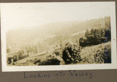
Photograph
The photograph is from the album of Ivy Child. The scene is looking across the Kalorama Valley with land cultivated by the Jeeves family. Ivy May Child (1910 – 1989) was the daughter of Arthur Edward (Ted) Child (1878 – 1964) and Ethel May Madden (1888 – 1970). Ted Child was the son of Matthew Francis Child (1839 – 1933) and Martha Jeeves (1857 – 1926). He was the grandson of one of the early pioneers Francis Child. Ivy grew up on the family property on Childs Road and took many photographs. Most of these are glued into her photo album. The album covered the years from c1927 – 1932. Ivy married Henry William Burgess (1906 – 1968) in 1944. The photographs remain in their original state in the album with individual copies made. Black and white photograph with bushes in the foreground, hills in the distance and a cleared, cultivated area in the centre.Below the photograph in the album" LOOKING INTO THE VALLEYkalorama, kalorama valley, jeeves, valley -
 Melbourne Legacy
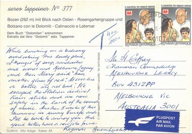
Postcard - Document, postcard
A postcard to the Comradeship Committee when a Legatee was travelling in Austria. "Bozen mit Blick each Osten" which translates as "Bolzano with view to the east". It is addressed to Mr H Caffrey, Chairman Comradeship at Melbourne Legacy. It is not dated and is signed Brian Lucky Luscombe. It says: "While lunching on a balcony overlooking this lovely place, I thought of soup, sandwiches and scones and Melbourne Legacy. And then Mary said "have another glass of red". At 6000 lire a bottle it's not too bad. We escaped the Italian airline/train strike and are now safely in the land of the Sound of Music. Another 5 weeks of this summer in sunny Europe and I'll be back to annoy you. And you'd better have a new job for me. Regards. Brian Lucky Luscombe.A record of a Legatee travelling and relating experiences back to his comrades in Melbourne.Colour postcard from Austria.Printed "Bozen mit Blick each Osten". Two Austrian postages stamps and an Airmail sticker. Handwritten text in blue pen.comradeship, legatee -
 Bendigo Historical Society Inc.
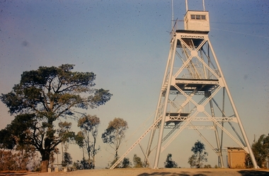
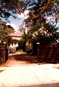
Slide - Peter Ellis Collection, Kaweka Wildflower Reserve, Castlemaine, Lightning Hill Lookout Bendigo, One Tree Hill Lookout Tower Bendigo, Kamarooka Forest Area, c1970-1972
Kaweka Reserve is a a small reserve of approximately 8ha. The land was donated to the Castlemaine City to be a wildflower Reserve. A management committee was formed in 1966. The committee is still managing the park. Vicroads Edition 6: Map 59E2, 628 H4 Location. Turner St, Castlemaine. From the Castlemaine Post Office, drive north (towards Bendigo) and turn right along Turner Street to the park entrance. What to do: walk along some of the tracks through the park follow the nature trail bird watch have a picnic at the picnic tables. RUSH Dam is a basic free camping area sits alongside Rush Dam in the Greater Bendigo National Park, featuring a single picnic table and wood fire barbecue.Peter Ellis Collection: Seventeen slides of Kaweka Wildflower Reserve, Castlemaine, Lightning Hill Lookout Bendigo, One Tree Hill Lookout Tower Bendigo. Also the Rush Dam free camping area at Kamarooka. Also a slide of an unknown group having a meal or day out; perhaps also a working bee. In addition there are two slides of a house - location not specified; and a working bee clearing along a pipeline at Big Hill. Peter was a chemistry lecturer at the Bendigo Institute of technology.history, bendigo, peter ellis collection, whipstick bendigo, bendigo state forests, kaweka wildflower reserve castlemaine, one tree hill lookout bendigo, lightning hill lookout bendigo, kamarooka, rush dam kamarooka, greater bendigo national park -
 Surrey Hills Historical Society Collection
Photograph, Rear of Varndean from Willcyrus Street, 1988, 1988
Ref: Alan Holt records - This property has had a number of different names throughout its history. William Cook, a farmer, bought the land it stands on in 1876. In 1882 he was rated for a house (not the current one) on 11 acres. The present house was built in 1885 by John Clark, an auctioneer. In 1888 the Tower Hill estate and the home (Tower Hill Lodge) were auctioned, but the house was not sold. In 1889 the house was purchased by Captain Shepherd. Records show that in 1894 the owners were Mr Thomas and Mrs Hortenzia Howell. They named the house 'Corcovado'. Later they added a study with a corner designed to provide views from the Dandenong Ranges around to Mt Macedon. In 1944 Mr and Mrs Lionel Adams renamed the house 'Varndean'.This is one of the earliest surviving houses in Surrey Hills.A colour photo taken from the street at the rear of a Victorian-style house with ornate chimneys and a slate roof. A parked car is seen in front of the house. The house sits behind a timber fence and is partly hidden by mature shrubs and trees.victorian style, tower hill lodge, corcovado, varndean, tower hill estate, mr william cook, mr john clark, mrs hortenzia howell, mr lionel adams, mrs lionel adams, surrey hills, captain louis shepherd, mr thomas howell -
 Surrey Hills Historical Society Collection
Photograph, Nethercourt Private Hospital, Union Road Surrey Hills in late 1930s
In 1935 Mrs Eliza tank transferred her private hospital 'Nethercourt' from Wilson Street to 219-223 Union Road. She has operated it at the Wilson Street address from 1916. The Union Road building had originally been Surrey College, a boarding school for boys built in 1889 by Rev Dr Darling. It was not the success hoped for. In 1905 it briefly became Milverton College for girls, after which it was used as a nursing home or small private hospital. By the 1960s it was known as 'Norwich Hospital' and later still 'St Jude's'. It closed as a hospital in 1983. The land at the front facing Union Road was sub-divided off and the building became a private home fronting Barton Street. As a private residence it was rendered and painted.Black and white photo of a double-storey brick building with a tower. There is a veranda between the tower and one of the wings of the building. This is enclosed at the upper level. On one side there is an external set of stairs and an out building. The building is approached by a circular driveway. There are mature bushes in front of the building.On copy photo in lead pencil: "? No & if missing"; "This is a copy"; "595"nethercourt hospital, milverton college, matron eliza tank, norwich private hospital, rev darling, st judes private hospital, hospitals, surrey college -
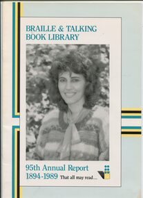 Vision Australia
Administrative record - Text, Braille and Talking Book Library 95th Annual Report 1894-1989: that all may read, 1989
Annual report of the Braille & Talking Book Library including Minutes of the AGM, Board of Director's Report, President's report and financial statements. Items also included are: the legacy of Mary Daly (consisting of 2 houses), launch on March 5 of LBP LTD by Minister of the Arts Ian Cathie, the death of Stephen Murray-Smith, the revaluation of land and buildings from 1918 value of 18000 pounds to $1,250,000, purchase of small property at 46 Commercial Road (opposite Library) to alleviate over-crowding, Mike Janes joins Board, Referendum materials produced for the AEC, purchase of Versabraille, acquisition of a fax machine, implementation of computer in technical services halted, new shelving purchased for the library, and Clarke & Smith books actively being phased out.1 volume of text and illustrationsbraille and talking book library, annual report -
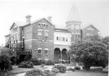
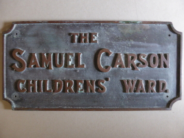 Warrnambool and District Historical Society Inc.
Plaque - Brass Plate, The Samuel Carson Childrens' Ward, C 1925
Samuel Carson was a local farmer who in the late 1800's acquired land to the West of Warrnambool in the Farnham park estate and towards Tower Hill near Gorman's lane. By the time of his death on May 23, 1920 he left an amount of 11666 pounds. Apart from amounts left to individuals, he bequeathed one hundred pounds each to ten different orphanages, and homes for neglected children and the blind and leaving the remainder to charitable organisations at the discretion of his trustees.The donation of 3500 pounds in August 1922 was in the latter category. This plaque commemorates Samuel Carson's generosity to the newly refurbished Warrnambool Base Hospital. He left a son William who farmed at Yangery at the time of his father's death. This item is significant in that it links a local identity through his generous donation to the local hospital. It therefore has strong social,historical and interpretative value. His generosity is a significant part of the history of Warrnambool Base Hospital.Heavy rectangular cast brass plate with raised edge and text in capitals. Corners have rounded cutouts and there is a hole in each corner for attachment. The Samuel Carson Childrens' Ward.warrnambool, warrnambool base hospital, samuel carson, samuel carson warrnambool, childrens' ward warrnambool 1928 -
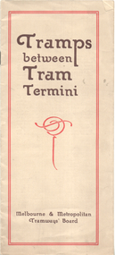 Melbourne Tram Museum
Booklet, Melbourne & Metropolitan Tramways Board (MMTB), "Tramps between tram termini", c1930
Booklet - promoting tram travel and walking trips or "tramps" between various tram terminus. Includes notes on the Board's services, its tourist tram with notes and fares on specific walks. Includes a map and some photos for each walk. 1 - Brighton Road to Hawthorn 2 - Burwood to Mont Albert 3 - Carnegie to Darling Road 4 - Whitehorse Road to East Kew 5 - Glen Iris to Darling Road 6 - Maribyrnong River to Mt Alexander Road 7 - Gardiner or Glen Iris to Burwood 8 - Wallen Road Bridge to Glenferrie Road 9 - Johnston St Bridge to Victoria Bridge At the time, some of these walks would have been through largely undeveloped land and parks.Demonstrates a promotion of the MMTB tram services and leisure activities.Booklet - 16 pages, two colours on light fawn paper, centre stapled.tramways, showgrounds, william st, mmtb -
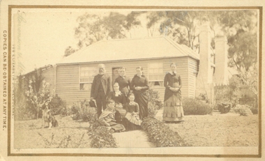 Bacchus Marsh & District Historical Society
Photograph, Cameron family at Glen Head farm house near Bacchus Marsh 1883
Malcolm Cameron, came from Scotland to Australia with his wife Isabella in 1862. From late 1862 they lived in Bacchus Marsh and remained there for the rest of their lives. After working as a shepherd for some time, Malcolm Cameron was able to acquire land for a farm a few kilometres north west of Bacchus Marsh. The farm was called Glen View but this was later changed to Grand View. It is known to have been a wheat farm. Malcolm Cameron died aged 89 in 1922. His wife died in 1926. Mrs Cameron is presumed to be the woman seated in the photograph and the younger people the Cameron children, Catherine (b.1863), Marion (b.1864)), Mary (b.1867), John (b.1870) and Isabella (b.1872). Small sepia unframed photograph on card with gold border framing photograph. Housed in the album, 'Photographs of Bacchus Marsh and District in 1883 by Stevenson and McNicoll'. The image shows a family group, the Cameron family of Bacchus Marsh, standing and sitting in the garden in front of their farm house. The group comprises four women, a girl, a boy and an elderly man, who is presumed to be Malcolm Cameron. The woman seated in the middle of the group is likely to be Mrs.Cameron. To the left in the picture is a dog. In the background is the weatherboard farm house, a simple construction with two large chimneys and a skillion extension.On the front: Stevenson & McNicoll. Photo. 108 Elizabeth St. Melbourne. COPIES CAN BE OBTAINED AT ANY TIME. On the back: LIGHT & TRUTH inscribed on a banner surmounted by a representation of the rising sun. Copies of this Portrait can be had at any time by sending the Name and Post Office Money Order or Stamps for the amount of order to STEVENSON & McNICOLL LATE BENSON & STEVENSON, Photographers. 108 Elizabeth Street, MELBOURNE. stevenson and mcnicoll 1883 photographs of bacchus marsh and district, farmers, farms, wheat farms, cameron family bacchus marsh -
 Eltham District Historical Society Inc
Photograph, Tess Justine (Nillumbik Shire Council), Murray's Bridge over the Diamond Creek, Eltham North, 19 Feb 2022
Murray's Bridge over the Diamond Creek on the Diamond Creek Trail just prior to demolition and replacement with a new steel bridge. Heritage advice obtained by Nillumbik Shire Council, following a suggestion by the Eltham District Historical Society (EDHS), is that the original bridge appears to have been a simplified version of the Country Roads Board’s (CRB) standard timber bridge design of the early-to-mid 1920s. In c1990 Murray’s bridge was renovated with three recycled steel girders as part of a bike/pedestrian path in the reserve. During these alterations many parts of the bridge were removed, and some were replaced. Heritage advice indicates the condition of Murray’s bridge is poor. The remaining original parts are all in poor condition, with severe weathering, splitting and rot, especially to the stringers retained on the bridge. Heritage advice is that Murray’s Bridge does not have sufficient significance in the cultural history of the Nillumbik area to warrant inclusion in the Nillumbik Shire Heritage Overlay and also does not have sufficient significance as a rare survivor to warrant inclusion in the Nillumbik Shire Heritage Overlay. There are no indications in the historical record that this site was individually important to the cultural history of this area. EDHS is comfortable with the heritage advice provided to Council and has worked closely on this project with Council. EDHS has suggested some of the removed timbers be used in the vicinity of the bridge for landscaping and possibly seating, so as to retain these remnants close to the site of the original bridge, which is the last old timber bridge along the lower reaches of the Diamond Creek. Mary (Sweeney) Murray and John Wright Murray selected 80 acres, Lot C Section 16 and Lot 5 Section 17 Parish of Nillumbik, under an occupation license in 1866. John died in 1867 and freehold was granted to his son John in 1873. The farm was known as ‘Laurel Hill’. John Junior was an Eltham Shire councillor and sometime president from 1887 up until 1897. He added Lot A Section 16 to the farm in ca1888. John and his younger brother James arranged to rent/purchase Lot B Section 17, across Diamond Creek to the west, in ca1900. It appears that John and James farmed separately for a few years, with a new homestead built for James ad family on the high point of Lot B Section 17 in ca1910. John sold off Lot 5 Section 17 in 1912. When John died in 1912 James took over the land on both sides of the Diamond Creek. The old homestead on the west side of the Creek disappeared. A farm bridge over Diamond Creek from this period may have been located close to the northern boundary of the farm. John Langlands, owner of the farm known as ‘Ihurst’ on the west side of Diamond Creek to the south of the Murray’s land, died in 1907. In 1909 his land was then subdivided into 100 lots to become the ‘Glen Park Estate’. Other similar subdivisions of nineteenth century farms around Eltham in this period included the ‘Franktonia (or Beard’s) Estate’ to the northeast and ‘Bonsack’s Estate’ between Eltham and Greensborough. Soon after the opening of the railway extension line from Eltham to Hurstbridge in 1912, Glen Park and nearby residents including James Murray agitated for a railway station or siding to be located half-way between Eltham and Hurstbridge, so that the Glen Park residents who used the railway daily did not have to walk into the Eltham or Hurstbridge stations. Some believed Coleman’s Corner (opposite Edendale Farm) was an appropriate spot for the platform. James Murray was among those who thought the railway should be located on his land, closer to half-way between Eltham and Hurstbridge stations. The Railways Commissioners warned that the locals would have to fund these works themselves. The Glen Park Estate residents initially had difficulty accessing Eltham by road, with only an old low-level bridge over Diamond Creek at the south end of their estate. A new timber trestle bridge across the creek, now on Wattletree Road, was opened in 1915. Road access to the north was gained in 1927 when the new Murray’s Road, which crossed the Murray’s land, was built. Residents continued to agitate for a Glen Park station. By 1926 the Railways Commissioners’ preferred site was on the Murray’s land. They arranged an estimate of cost of a full-length platform. The estimate was too much for the locals, who in 1928 argued unsuccessfully for a shorter and hence cheaper platform. By 1929 Murray had agreed to donate the land, but the locals would still have to fund the works. Murray decided, unilaterally it would appear, to commence work on a timber trestle road bridge over Diamond Creek to link the new Murray Road to the proposed station. Late in 1929 he stopped work on the bridge, for reasons unknown, but started work again and completed the bridge in 1931. There is no further newspaper evidence of the campaign for the Glen Park station until 1939, when Murray and another local, Mr Maxwell, met the Railways Commissioner. The Glen Park locale now included 45 homes on the west side of the creek and 20 on the Eltham side. Most of the residents used the train every day. The Commissioner remained adamant that only a full-length platform could be built for safety reasons. It appears the campaign dissolved at this point. The increasing move to cars may have had an impact. There is no evidence of Murray’s bridge ever being connected to Murray’s Road, or of it having wide use for any purpose by locals. James Murray died in 1947 and the farm was taken over by his son James (Jim). Jim started to sell off parts of the farm in the 1980s, retaining a few acres around the ca1910 homestead and building a new house there. Recreation reserves were established along the creek. In ca1990 Murray’s bridge was renovated with steel girders as part of a bike/pedestrian path in the reserve. The old farmhouse was demolished in ca2014. * * * A theory posted on local community Facebook groups was that the bridge was built in the 1860s and was built to be more robust than was necessary for the movement of cows from one side of the creek to the other. It was suggested the robustness was necessary to support the weight of gold ore being transferred from a mine on Murray’s land to a railway siding near Murrays Bridge (presumably for transfer and processing at Diamond Creek). Perhaps this may have been one of the motivators for Murray, who really knows? Knowing when mining operations ceased on his land and how that fits the overall timeline would be useful but at the time the bridge was built, local gold production was minimal at best. The known facts are: • The railway line came to Eltham in 1902. • The extension of the railway from Eltham to Hurstbridge was constructed in 1912 so no railway line even existed through Murray's property until 1912 and the Victorian Railways maps at the time show no such siding on Murray’s property. • In 1923 a new company was formed in anticipation of the old Diamond Creek Gold Mine being re-opened. The mine had been previously closed and flooded. It was noted in the press at the time that the mine was within a mile of the railway. Nothing really came of this. • Construction of Murrays Bridge was commenced by James Murray in early 1929 in anticipation of a proposed flag station being nominated on his land, but work ceased shortly afterwards. The proposed flag station was commonly referred to as Glen Park as the residents of the Glen Park Estate wanted Option 1, located near them with the platform adjacent to Colemans corner. This was probably never going to fly as it was virtually in eyesight of Eltham station. Allandale Road was the third option, but the Commissioners' preferred option was No. 2 - on Murray's property. • The Railway Commissioners were not going to finance any such station and the works had to be funded by private landowners and residents, hence Murray investing in this himself. • Murray recommenced work two years later and finished his bridge in 1931 but unfortunately for him, the proposed flag station never eventuated. The bluestone siding you reference may well have been built by Murray as part of the proposed station platform. • Up until then, apart from the Main Road bridge, which was washed away in 1924, virtually all local crossings over the Diamond Creek were low lying bridges – Kaylocks Bridge at Brougham Street, Diamond Street bridge, Glen Park Road bridge. It is expected that Murray also had a low-lying bridge to connect his land either side of the creek. These were all washed away or severely damaged multiple times in the 1920s. Lessons were learnt, and Murrays Bridge appears to have been built in accordance with Country Road Board standards of the time. Flood damage was ongoing, and even more recently constructed raised bridges kept getting washed away, e.g., the new Wattle Tree Road bridge in 1958 just months after completion. Murray’s bridge was reinforced with steel some 30 years ago presumably to provide additional floodwater resistance, given the history of bridges disappearing in floodwaters. • In March 1932 it was reported in the Advertiser that there were still some prospectors operating around Eltham North who apart from further scarring the face of the earth over the previous two years had gained significant experience but little gold - hardly a driving factor for constructing a dedicated railway siding and bridge to transfer gold ore. It is far more probable that James Murray was hoping to have the railway station located on his property and invested his money by building the bridge to lead to it as well as a station platform. Had the station eventuated, it may well have driven up the value of his land for subdivision and new housing estates like the Glen Park Estate. That did not eventuate. Whilst the bridge was indeed old (90 years), the core structure being completed in 1931, it had been modified substantially from original and hence had no significant historic value – i.e., it was not a representative example of its type, construction, and age. Given that the bridge was not worthy of saving, the Eltham District Historical Society with Council’s support, and the Eltham Woodworkers group endeavoured to see what suitable sized timbers were salvageable to fabricate a commemorative seat. Unfortunately, the experts at the Woodworkers group were unable to salvage any suitable length/width timbers to fabricate the seat due to the presence of rot. Last remaining wooden trestle bridge on the Diamond Creek Trail just prior to demolition and replacementBorn digital image (27)diamond creek (creek), diamond creek trail, murrays bridge, ‘laurel hill’, john wright murray, mary (sweeney) murra, john murray jnr, james murray, john langlands, ‘ihurst’, ‘glen park estate’, beard's estate, franktonia, bonsack's estate, glen park estate, glen park railway station -
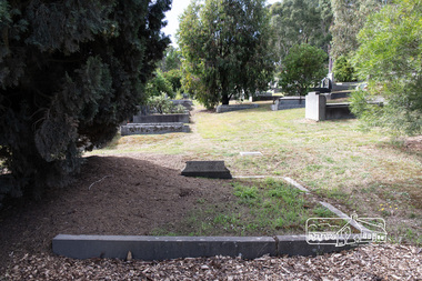 Eltham District Historical Society Inc
Photograph, Peter Pidgeon, Grave of David George and Elizabeth Clark, Eltham Cemetery, Victoria, 5 April 2021
David George Clark was the first and longest-serving headmaster at Eltham State School No. 209 (Eltham Primary) in Dalton Street, Eltham. David (then aged 26) and his sister Catherine first established their ‘private’ school which began in 1855 and was held in the Wesleyan Chapel in Henry Street, a slab built, shed-like building on land acquired by the Church in January 1855. Parents lobbied the Government to establish an official school, and a School Inspector came out to investigate. He found that the Clarks were of good moral and religious character (David taught Sunday School at St. Margaret's later on) and gave them his endorsement despite some perceived technical shortcomings. In 1856 a small stone building of 40 feet by 16 feet was erected on the school's present site at the corner of Main Road and Dalton Street. Half of the building was the school, the other half was the residence of David and Catherine and their mother, also Catherine. It appears that they were well respected by the local community: David constantly battled with the authorities to have facilities (such as toilets) at the school improved. As enrolment gradually increased, over-crowding became an issue. As well, David married Elizabeth in 1863. Needing to move out of the schoolhouse, in 1866 the Clarks bought a block of land in Metery Road next to the school and built the house "Shoestring" (which still exists albeit with significant modifications). Catherine retired in 1887 followed by David in 1889 after a period of ill health and was succeeded as Head Teacher by John Brown. David died in 1911 and is buried with his wife Elizabeth in Eltham Cemetery. In Loving Memory Of D. G. & E. ClarkBorn Digitaleltham cemetery, gravestones, david george clark, elizabeth clark, eltham primary school, eltham wesleyan chapel, state school no. 209 -
 Eltham District Historical Society Inc
Photograph - Colour Print, Belle Vue, Livingstone Road, Eltham, c.2015
Belle Vue property in Livingstone Road, Eltham was once owned by Society member Jo McCormick. Jo was a valued member of our committee and dear friend of many of our members until her death in 2009. Belle Vue is the farmhouse of a property that is now a significant part of suburban Eltham, just a short distance north of the town centre. Originally purchased by pioneer Eltham farmer Henry Stooke, the present-day old farmhouse sits within an extensive suburban residential area. The history of the property is largely based on a heritage assessment prepared by consultant Lorraine Huddle for Nillumbik Shire Council. Additional information from our Society records reveals Belle Vue farm comprised about 56 ha (140 acres) extending northerly from the northern boundary of Holloway’s 1851 Little Eltham subdivision. On the present day map the southern boundary was just north of Elsa Court and Grove Street. The western boundary was the Diamond Creek and extended northerly to Main Road where it turns easterly towards Research. It was traversed by the main road to Kangaroo Ground and beyond and from 1912 by the railway to Hurstbridge. From 1895 the farm was owned by William Williams and his wife Mary Ann. In 1914 -15 they built a new house now known as Belle Vue. They sold the land in 1920 and residential subdivision began soon after that. Belle Vue remains today on a substantially subdivided and very much reduced size residential lot in Livingstone Road. The house and many old trees on the site were subject to a heritage overlay under the Nillumbik Planning Scheme. Despite that overlay, the development and subdivision of the original land resulted in most of the heritage listed trees being removed. belle vue, eltham, livingstone road -
Eltham District Historical Society Inc
Document - Folder, Newman, Charles
British army officer Major Charles Newman was an early settler on the Yarra River at Templestowe after serving in India in the East India Company. Later be married and moved to Tasmania, farming at Black Brush near Pontville. In 1835 he came to the Port Phillip District and explored the Yarra River, returning with his family. David Crockett and Hazel Poulter researched, respectively, Charles Newman and the Templestowe area, identifying the Newman house, Pontville, on the Yarra banks. David Crockett also researched James and Anne Anderson. Contents Newspaper article: "David fills in the gaps", Diamond Valley News, 16 December 1986.29 October 1985, p62. Story of Charles Newman and of David Crockett and Hazel Poulter's researches. Letter, A (Tony) B Owen to Eltham Historical Society, 12 March 2018, enclosing information about Major Charles Newman. Email, Eltham District Historical Society to Tony Owen, acknowledging receipt of information about Major Charles Newman. Photocopy of pages from "Glimpses of Life in Victoria", pp38-43. Flier, "Heritage Events in Nillumbik, 2005". Photocopy of pages from unidentified volume, chapter headed "The Bush", and part chapter IV "Bushrangers". Warrandyte Historical Society publication "The Wurundjeri Clan of the Kulin". Whitehorse Manningham Heritage Network search results for "Andersons Station on the Yarra Yarra", "A brief history of Warrandyte", "The branch is broken", "Melbourne's historic home", "Land with infamous past", "Charles Newman's original grave at Monckton", and "Site of Major Newman's land". Photocopy of pages from "Templestowe - a folk history", Hazel Poulter, 1985,: "The squatter, Major Charles Newman".Newspaper clippings, A4 photocopies, etccharles newman, british east india company, templestowe vic, warrandyte vic, david crockett, hazel poulter, james anderson, anne anderdon, a b owen, wurundjeri clan of the kulin, andersons station on the yarra river -
 Victoria Police Museum
Police Stations (Ararat)
Ararat is a city in south-west Victoria, Australia, about 198 kilometres west of Melbourne, on the Western Highway on the eastern slopes of the Ararat Hills and Cemetery Creek valley between Victoria's Western District and the Wimmera. It is named after Mount Ararat 10 kilometres south-west of the town. A police station opened in Ararat in 1859, though there was a police presence in the area formerly known as Cathcart, Canton Lead and later Mount Ararat. In 1861 staff consisted of 1 Superintendent, 2 Mounted Constables, 1 Sergeant 2nd class, 1 Senior Constable, 8 Constables. The police reserve was on land bounded by Ligar Street, Barkley Street, Ingor Street and High Street. In 1930 the police station was described as a six-room brick dwelling with a slate roof, situated on one quarter acre of land. There was also a bathroom, wash-house, pantry, office, muster room and quarters for a single constable, stables with three stalls, and a lock-up consisting of two six-person cells. Later residences were located at 3 Ligar Street (brick veneer with a tile roof); 32A High Street (brick veneer with tile roof); and 3 Tobin Street (wood with an iron roof). A new, purpose built police station was opened in October 2010 at 77 Barkly Street. The Ararat Police District was reformed into the Wimmera Police District in 1870. Ararat Police Station became part of "R" (Glenelg) District in January 1948 and "M" (Highlands/Wimmera) District from March 1990. A list of police stationed at Ararat from 1903 - 1930 is available from the Victoria Police Museum8 photos comprising: 7 black & white photos 1 colour photopolice stations; ararat police station -
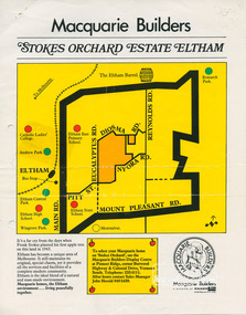 Eltham District Historical Society Inc
Document, Stokes Orchard Estate Eltham; Macquarie Builders, 1979c
Sales brochure including photocopy map of Stokes Place lots and Sales Manager's business card (John J. Herold). Stage 1 implemented c.1976 and Stage 2 c.1979. As shown on the plan, the lots along Diosma Road did not eventuate due to the lack of sewer system. These lots and streets were divided up into 5 acre blocks, which were not able to be subdivided till the 1990s when the sewer was run up Diosma Road. Stokes Place was part of the Stokes Orchard Estate which was developed from the break-up of the the orchard owned by Frank Stokes who lived on the northeast corner of Nyora Road and Eucalyptus Road. His daughter Beryl advised that the Shire had levied a rate assessment on individual parcels of land within the orchard which became unaffordable resulting in its sub-division and sell off. The Stokes Orchard Estate was developed by Macquarie Builders in two stages starting with stage 1 in 1976. Stokes Place was part of Stage 2 in 1979. The Estate was bounded between Nyora Road, Eucalyptus Road, Diosma Road and Stokes Place. The original orchard only just reached the left most portions of Stokes Place and did not go fully up to Diosma, rather to just beyond the extant of Stokes Place. Stokes Place was known within the family as "The Oats" as that is where they grew oats. Frank Stokes moved to Eltham c.1945 after visiting Harold Bird to view his orchard, located diagonally opposite Stokes Orchard from the intersection of Eucalyptus Road, Pitt Street and Nyora Road. It was on Harold Bird's recommendation that Frank purchased the land.The Stokes Orchard Estate collection is typical of housing developments of the late 1970s and 1980s. It was one of the earliest estates in Eltham following the nearby Woodridge Estate development.A4 colour brochure double sided, A4 photocopy and business cardAs notedstokes place, eltham, stokes orchard, stokes orchard estate, streets, houses, peter and carla vermey -
 Glen Eira Historical Society
Album - Album page, Glenferrie Street, 4, Circa 1972
This photograph is part of the Caulfield Historical Album 1972. This album was created in approximately 1972 as part of a project by the Caulfield Historical Society to assist in identifying buildings worthy of preservation. The album is related to a Survey the Caulfield Historical Society developed in collaboration with the National Trust of Australia (Victoria) and Caulfield City Council to identify historic buildings within the City of Caulfield that warranted the protection of a National Trust Classification. Principal photographer thought to be Trevor Hart, member of Caulfield Historical Society. Most photographs were taken between 1966-1972 with a small number of photographs being older and from unknown sources. All photographs are black and white except where stated, with 386 photographs over 198 pages. From Glen Eira Heritage Management Plan 1996 by Andrew Ward: In 1905, most of portion 27 was vacant land, however Glenferrie Street had been formed and the land subsequently subdivided. In 1906, Robert Joseph Haddon, architect and painter, designed and built for his private residence, a brick house on the west side. Haddon named the house "Anselm". Also built on the property were a garage and fibro cement studio. "Anselm" is architecturally important at the State level as a substantially intact, highly personalised and boldly expressed house expressive the Arts and Crafts movement and incorporating Art Nouveaux enrichment in a variety of forms, the use of ornamental terra cotta tiles to the comer tower being of special note. Its importance at the State level is strengthened by its place as the home of the noted architect and Melbourne's most influential exponent (Freeland, J.M., Architecture in Australia, p. 213) of the Art Nouveaux movement.https://vhd.heritagecouncil.vic.gov.au/places/4442 Victorian Heritage Register: What is significant? Anselm was designed by noted English born architect Robert Joseph Haddon(1866-1929) as his own house and constructed in 1906. A single storey Arts and Crafts influenced red brick house with attic, Anselm has a pyramidal slate roof with prominent chimney stacks. There is a octagonal corner tower with saucer shaped domed roof surmounted by a weather vane, and the tower has decorative terracotta panels immediately below the eaves line. The front door opens immediately into a large living or common room, screened from view by a timber and bottle glass screen. The large room was designed to function as a drawing and dining room. The house is rich with hand crafted details including door and window furniture, wrought iron gutter brackets, fireplaces (one with built in wood box), and fire tools. The interior decoration includes hand painted frieze of Port Phillip in the study, and a hand painted frieze of turbulent sea with sailing boats in the tiled bathroom. There is a small hand painted tile at the base of the tower which states ?This building was erected AD1906 from designs by Robt J Haddon FRIBA,Lond FRIVA Melb Architect?. He also designed an attic addition which was constructed in 1927. Anselm is substantially intact although the double casement window immediately to the south of the front door was originally circular....Page 60 of Photograph Album with three exterior photographs (one portrait and two landscape) of Anselm.Hand written: 4 Glenferrie Street [top right] / ANSELM 4 Glenferrie St [under top photo] / 60 [bottom right] trevor hart, anselm, art nouveaux, arts and crafts, tower, bay window, glenferrie street, robert joseph haddon, 1900's, terra cotta tiles, double storey, caulfield north, corner tower, gates, cast iron work -
 Glen Eira Historical Society
Album - Album page, Glenferrie Street, 4, Circa 1972
This photograph is part of the Caulfield Historical Album 1972. This album was created in approximately 1972 as part of a project by the Caulfield Historical Society to assist in identifying buildings worthy of preservation. The album is related to a Survey the Caulfield Historical Society developed in collaboration with the National Trust of Australia (Victoria) and Caulfield City Council to identify historic buildings within the City of Caulfield that warranted the protection of a National Trust Classification. Principal photographer thought to be Trevor Hart, member of Caulfield Historical Society. Most photographs were taken between 1966-1972 with a small number of photographs being older and from unknown sources. All photographs are black and white except where stated, with 386 photographs over 198 pages. From Glen Eira Heritage Management Plan 1996 by Andrew Ward: In 1905, most of portion 27 was vacant land, however Glenferrie Street had been formed and the land subsequently subdivided. In 1906, Robert Joseph Haddon, architect and painter, designed and built for his private residence, a brick house on the west side. Haddon named the house "Anselm". Also built on the property were a garage and fibro cement studio. "Anselm" is architecturally important at the State level as a substantially intact, highly personalised and boldly expressed house expressive the Arts and Crafts movement and incorporating Art Nouveaux enrichment in a variety of forms, the use of ornamental terra cotta tiles to the comer tower being of special note. Its importance at the State level is strengthened by its place as the home of the noted architect and Melboume's most influential exponent (Freeland, J.M., Architecture in Australia, p. 213) of the Art Nouveaux movement. Victorian Heritage Register https://vhd.heritagecouncil.vic.gov.au/places/4442 What is significant? Anselm was designed by noted English born architect Robert Joseph Haddon(1866-1929) as his own house and constructed in 1906. A single storey Arts and Crafts influenced red brick house with attic, Anselm has a pyramidal slate roof with prominent chimney stacks. There is a octagonal corner tower with saucer shaped domed roof surmounted by a weather vane, and the tower has decorative terracotta panels immediately below the eaves line. The front door opens immediately into a large living or common room, screened from view by a timber and bottle glass screen. The large room was designed to function as a drawing and dining room. The house is rich with hand crafted details including door and window furniture, wrought iron gutter brackets, fireplaces (one with built in wood box), and fire tools. The interior decoration includes hand painted frieze of Port Phillip in the study, and a hand painted frieze of turbulent sea with sailing boats in the tiled bathroom. There is a small hand painted tile at the base of the tower which states ?This building was erected AD1906 from designs by Robt J Haddon FRIBA,Lond FRIVA Melb Architect?. He also designed an attic addition which was constructed in 1927. Anselm is substantially intact although the double casement window immediately to the south of the front door was originally circular....Page 61 of Photograph Album with one exterior photograph (portrait) of Anselm.Hand written: 61 [bottom left] trevor hart, anselm, art nouveaux, arts and crafts, tower, bay window, glenferrie street, robert joseph haddon, 1900's, terra cotta tiles, double storey, caulfield north, corner tower, brick house, attics -
 City of Moorabbin Historical Society (Operating the Box Cottage Museum)
Photographs,x3 Colour Early Weatherboard Cottage Cheltenham c1880, 1981
Henry Dendy , a farmer from Sussex England, purchased 5,120 acres of land in the area of a 'Special Survey 1841' that extended from Brighton bayside North Road, East Boundary Rd to South Road. This area became known as Dendy's Brighton and as part of the sale 139 emigrant workers arrived in 1842 however Dendy was unable to find work and lodgings for these people. J.B.Were, financier took over the management of the 'Special Survey 1841' area and began to sell and lease allotments. 1850 the Squatter King brothers sold land south of Dendy's 'Special Survey 1841' to Josiah Holloway who sectioned it into 2 acre lots @ £10 each for market gardens - 'Two Acre Village' and Charles Whorral opened a small hotel - 'The Cheltenham Inn' on the main Road - Arthur's Seat Rd, later Point Nepean Rd, now Nepean Highway. Notable settlers who moved into the area were Keys, Charman, Bruton, Le Page, Fairlam, Meeres and 1862 saw the separation from Brighton and the formation of the Mooorabbin Roads Board District. .By 1879 1000settlers were living in 'Cheltenham' serviced by a Post Office with Bank, Mechanics Institute, State School No 84,Keys Hotel, Meeres Store, Sir Thomas Bent ensured the new Railway Line from Caulfield to Mordialloc went through his constituency of Cheltenham 1881 and this changed the development to the bayside area of Cheltenham away from the 'Two Acre Village ' side causing some dissention, However Cheltenham as whole prospered and this house in Pine St is typical of the cottages built c 1890- 1900 in the area. This weatherboard house c 1890-1900 in Pine St Cheltenham is typical of those built for early settler families. Photo taken 1981 by CMHS member 3 x Colour photographs of an early c 1900 weatherboard house in Pine St Cheltenham taken by CMHS member 1981Kodak Aug. 81 / Handwritten Pine St Cheltenhamkeys robert, holloway josiah, king brothers, smith j l; smith mary ann, stanley helen, chaff cutter, horse drawn carts, toll gates brighton, motor cars 1900, steam engines, early settlers, bentleigh, parish of moorabbin, city of moorabbin, county of bourke, moorabbin roads board, shire of moorabbin, henry dendy's special survey 1841, were j.b.; bent thomas, o'shannassy john, king richard, charman stephen, highett william, ormond francis, maynard dennis, market gardeners, vineyards, orchards -
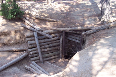 Victorian Interpretive Projects Inc.
Photograph - Colour, Gaida Stevens, World War One Tunnel Entrance, Lone Pine, Gallipoli, 2015, 2015
Lone Pine was an action that featured one of the most famous assaults of the Gallipoli campaign. The attack was planned as a diversion for the Australian and New Zealand units that were to breakout from the Anzac perimeter by capturing the heights of Chunuk Bair and Hill 971. At 5.30 pm on 6 August 1915, the Australian artillery barrage lifted and from concealed trenches in no man’s land the 1st Australian Brigade charged towards the Turkish trenches. The troops paused on reaching the Turkish trenches, finding that many were covered by timber roofs. Some fired, bombed and bayoneted from above, some found their way inside and others ran on past to the open communications and support trenches behind. Others advanced as far as "the Cup" which was where Turkish support units were located and from where the Turks counter-attacked. By nightfall, most of the enemy front line was in Australian hands and outposts had been established in former Turkish communication trenches. The Australian Engineers dug a safe passage across no man’s land so that reinforcements could enter the captured positions without being exposed to Turkish fire. Having captured the Turkish trenches, the Australians now tried to hold what they had taken while the Turks desperately and determinedly tried to throw the Australians out. From nightfall on 6 August until the night of 9 August a fierce battle ensued underground in the complex maze of Turkish tunnels. The Australians succeeded in drawing the whole of the immediate Turkish reserve. Six Australian battalions suffered nearly 2,300 killed and wounded at Lone Pine. Seven Australians were awarded the Victoria Cross, the highest number ever awarded to an Australian division for one action.(http://www.awmlondon.gov.au/battles/lone-pine)Entrance to a tunnel at Lone Pine, Gallipoli. gallipoli, world war one, tunnel, mmm -
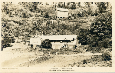 Mt Dandenong & District Historical Society Inc.
Photograph, Warwick Farm On Olinda Road
Information supplied by Stephen Trembath. Warwick Farm was established by my late grand parents Polly (nee Mary Ann Cole) and George Barratt and their 5 children George Jnr, William, James, John (my maternal Grand Father) and Teddy. Their story is told in a book "The wine of Courage" written in 1977 by N.M. Roberts ISBN 0 7223 1003. Their story started when their bank closed their doors on 13 April 1893 and they lost their cafe business in South Melbourne. Two days later, they were ready to head for a new start in Queensland when they saw in the morning paper that the Dandenong Ranges had been thrown open to land release to people. A few days later, having been granted land they headed to Ferntree Gully. From there they walked to the new holding in what would become Olinda. Then George with his sons help had to build a shelter for the family for the night. They chose to name the property "Warwick Farm". Work on the house started a few days later with help from neighbours Mr. Dodd, Mr Beattie, the O'Sheas and others. Come November, Ruby was born. Then bushfire burnt down the newly built house. Back to a bark hut until another house could be built. The new house became a guest house at the suggestion of a neighbour, when George couldn't sell timber and was waiting for crops. The first guests visited in 1898 and another baby, Percival, was born. ....................................................... It was George's son Jim, who was a skilled carpenter and axeman who extended the home to take from 12 to 30 guests. In 1950 Warwick Farm became the home of distinguished writer and journalist C.E.Sayers for a number of years.Photo Series Pictorial Postcard # 981 showing the property Warwick Farm on Olinda Road.Printed on back: PHOTO SERIES Pictorial Postcards. Published by S. Jamieson Bros. Alphington Vic. Phone Northcote 60warwick farm, olinda, postcard, photo series, olinda road, george barratt, barratt, guest house, guest house -
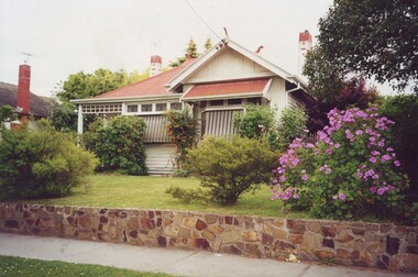 Surrey Hills Historical Society Collection
Photograph, 5 York Street, Mont Albert, November 1999 (1), 1999
This is the home of Ernest Augustus Young (1891-1985) and Ruby Nichell Whitby (1892-1984) and their son Ernest Lance Young. Lance was born 24 March 1915 in Surrey Hills; after he married Beryl Mair. Electoral roll for 1937 gives the house name as 'Whitby Lodge'. Ernest and Ruby also had twins Clive and James who died in infancy. Buried at Box Hill Cemetery - M-*-0867 (family plot) This is part of a large collection relating to the Mair, Deakin and Young families. REF: Memoir of Laurie Newton (nee Young) - Her grandfather bought the land and had the house built. She remembers it as having pressed ceilings in some rooms and ornate fireplaces and tiles and leadlight windows in some rooms and doors with leadlight panels. Her grandfather was a keen gardener with an ornamental front garden and many vegetables and fruit trees in the back yard. Her grandfather sold the adjoining block (No 3 York Street), which had been used for growing flowers and vegetables, to John and Edna Jean. Reid. She also remembered that he extended the house and divided it into 2 flats, renting out the northern side for 20 years. Sold by Jellis Craig on 24 December 2010 - With formal living, dining, 3 bedrooms, 2 bathrooms, garage/ample OSP. Land: 18.2m x 40.8m (60' x 134') approx. Large 2 storey house replaced the house. Adjacent house (No 7 York Street) has been renovated. This is part of a large collection relating to the Mair, Deakin and Young families. Colour photo of the street view of 5 York Street, Mont Albert. Taken from the verge, it is a good view of the front of the house. The house is weatherboard with a red corrugated iron roof with simple finials. It is Edwardian in style with simple chimneys in brick and stucco. There is a small veranda with simple fretwork on the southern corner of the house and a bay window to one of the front rooms. There are striped canvas blinds, which are down, on the windows of the 2 front rooms, above which are small lead light windows. The house is partly screened by a mature shrubs. The garden is set behind a fence low fence and constructed from dressed stone. In black permanent marker on rear: "5 YORK ST / NOV. 1999" ernest augustus young, ruby nichell whitby, ruby nichell young, ernest lance young, box hill cemetery, whitby lodge, house names, mont albert -
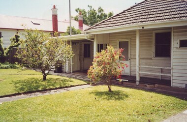 Surrey Hills Historical Society Collection
Photograph, 5 York Street, Mont Albert, November 1999 (2), 1999
This is the home of Ernest Augustus Young (1891-1985) and Ruby Nichell Whitby (1892-1984) and their son Ernest Lance Young. Lance was born 24 March 1915 in Surrey Hills; after he married Beryl Mair. Electoral roll for 1937 gives the house name as 'Whitby Lodge'. Ernest and Ruby also had twins Clive and James who died in infancy. Buried at Box Hill Cemetery - M-*-0867 (family plot) This is part of a large collection relating to the Mair, Deakin and Young families. REF: Memoir of Laurie Newton (nee Young) - Her grandfather bought the land and had the house built. She remembers it as having pressed ceilings in some rooms and ornate fireplaces and tiles and leadlight windows in some rooms and doors with leadlight panels. Her grandfather was a keen gardener with an ornamental front garden and many vegetables and fruit trees in the back yard. Her grandfather sold the adjoining block (No 3 York Street), which had been used for growing flowers and vegetables, to John and Edna Jean. Reid. She also remembered that he extended the house and divided it into 2 flats, renting out the northern side for 20 years. Sold by Jellis Craig on 24 December 2010 - With formal living, dining, 3 bedrooms, 2 bathrooms, garage/ample OSP. Land: 18.2m x 40.8m (60' x 134') approx. Large 2 storey house replaced the house. Adjacent house (No 7 York Street) has been renovated. This is part of a large collection relating to the Mair, Deakin and Young families. Colour photo of the street view of 5 York Street, Mont Albert. Taken from the rear of the house verge, it is a good view of the front of the house. The house is weatherboard with a red corrugated iron roof with simple finials. It is Edwardian in style with simple chimneys in brick and stucco. There is a small veranda with simple fretwork on the southern corner of the house and a bay window to one of the front rooms. There are striped canvas blinds, which are down, on the windows of the 2 front rooms, above which are small lead light windows. The house is partly screened by a mature shrubs. The garden is set behind a fence low fence and constructed from dressed stone. In black permanent marker on rear: "5 YORK ST / NOV. 1999" ernest augustus young, ruby nichell whitby, ruby nichell young, ernest lance young, box hill cemetery, whitby lodge, house names, mont albert -
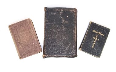 Wodonga & District Historical Society Inc
Book - Haeusler Collection - Bible and Hymn books, c1890s
The Wodonga Historical Society Haeusler Collection provides invaluable insight into life in late nineteenth and early twentieth century north east Victoria. The collection comprises manuscripts, personal artefacts used by the Haeusler family on their farm in Wodonga, and a set of glass negatives which offer a unique visual snapshot of the domestic and social lives of the Haeusler family and local Wodonga community. The Haeusler family migrated from Prussia (Germany) to South Australia in the 1840s and 1850s, before purchasing 100 acres of Crown Land made available under the Victorian Lands Act 1862 (also known as ‘Duffy’s Land Act’) in 1866 in what is now Wodonga West. The Haeusler family were one of several German families to migrate from South Australia to Wodonga in the 1860s. This Bible belonged to Louis Alfred Haeusler, son of Johann Heinrich Ferdinand Haeusler and Ernestine Wilhelmine nee Rogasch. Louis was born in Wodonga, Victoria on 23 December 1898 and died on 2 February 1960. The other 2 volumes belonged to Louis' sister Eleonora Lydia Haeusler (Nellie), born 14 October 1883 and died 25 November 1979. Louis was the father of John Alfred Lyell (Alf) Haeusler who bequeathed this collection to the Wodonga Historical Society. The Bible was published by Collins' Clear Type Press, a Scottish publishing company founded in 1892.The volume "Church Hymns" was published by the Society for Promoting Christian Knowledge, the oldest Anglican missionary organisation which was originally founded in 1698. This copy was published in London C1885. The Hymnal Companion to the Book of Common Prayer (2nd Edition) was published by Sampson Low, Marston and Company of London C1893.This item is unique and has well documented provenance and a known owner. It forms part of a significant and representative historical collection which reflects the local history of Wodonga. It is representative of the religious traditions adopted by this family in Wodonga. A collection of 3 religious books including a Bible, Hymn book and Hymn Book companion. They have different coloured leather covers. Handwritten inside front cover of Bible: L.A. Haeusler/ Wodonga, Vic. Handwritten inside front cover of Hymnal Companion: Eleonora L. Haeusler / St. Lukes, Wodonga Handwritten inside Church Hymns: To Nellie with love from Sister Tilly 20.8.02haeusler family, religious publications, society for promoting christian knowledge, sampson low, marston and company -
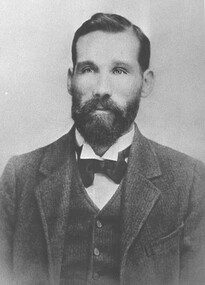 Wodonga & District Historical Society Inc
Photograph - Michael "Mick" Mulqueeney Stock Agent, Wodonga
Mick Mulqueeney was born in Kilmore and arrived in Wodonga in 1886, when it was Australia's greatest store cattle market. It was not unusual to see 10,000 cattle sold in a single day. For a few years he spent time overlanding large mobs of cattle from Queensland and the back country of N.S.W He settled in Wodonga and began business as a stock and station agent at Wodonga. He was the Wodonga representative of Edward Trenchard and Co, and other Newmarket stock agents but also conducted auctions on his own account. For several years, he was in partnership with Mr A. L. Wright. Following the retirement of Mr. Wright in 1902, Mick Mulqueeney then joined with Harry H Peck under the trade name of Peck Sons and Mulqueeney. This partnership was dissolved after about 10 years and Mick was bought out by New Zealand Loan. Later he continued in stock and station agency on his own. During this time, he also conducted a very extensive stock forwarding agency where tens of thousands of stock of all classes were shipped owing to the break of gauge from N.S.W, into Victorian trucks and vice versa. He was regarded by stock owners as a genius among stock. Michael also had a sound knowledge of land in the Wodonga district and when the settlement of returned soldiers onto the land was taking place he was appointed valuer of properties being considered by the Repatriation Department. Mick also became a Government stock inspector on the Victorian side of any stock crossing the border. At this time his forwarding agency was carried on by his son, Mr. Jack Mulqueeney. Michael Mulqueeney died on 19th June 1929 and was buried at Yackandandah, VictoriaThis photo is significant because it depicts an important member of the Wodonga community and an vital industry in Wodonga.Two black and white images showing a portrait photo of Michael Mulqueeney and the Mulqueeney family home.michael mulqueeney, stock agents wodonga, livestock sales wodonga -
 Eltham District Historical Society Inc
Audio - Audio Recording, Audio Recording; 2018-10-13 Eltham Community Town Hall Meeting, 13 Oct 2018
Meeting to discuss the Nillumbik Shire Council's proposed sale and devlopment of the former Shire Office site at 895 Main Road as well as the Eltham War Memorial including the Maternal and Infant Welfare Centre, Eltham Pre-school and Eltham War Memorial Hall and Memorial Gardens at 903-907 Main Road which also includes thje Eltham Senior Citizen's Centre. The meeting was attended by more than 300 people which considered the following: Motion from public meeting – Saturday 13th October, 2018 1. This meeting has no confidence in Nillumbik Shire Council's proposed process for the re-development of 895 and 903-907 Main Rd, Eltham and we deplore the cursory attention given to public consultation to date. 2. We call on Council: *to preserve the Eltham War Memorial building complex at 903-907 Main Rd, Eltham, and retain their existing uses in accordance with the Eltham War Memorial Trust purpose; and retain the Cenotaph and Eltham Senior Citizens' Centre. * to retain council ownership of all land at 895 and 903-907 Main Rd, Eltham for our community and future generations. * following meaningful engagement with residents of the Shire, to place sufficient planning controls on the site of the former Eltham Shire Office to ensure that any future development of that land responds to Eltham's form and character and properly protects public amenity, access and use. * to make all proposals for the development of 895 and 903-907 Main Rd, Eltham available for public inspection as soon as they are received by Council. Moved: Greg Johnson Seconder: Andrew Lemon * carried unanimously1:28:52 duration Digital MP3 File 30.5 MB 895 main road, 903-907 main road, community meeting, eltham pre-school, eltham shire office, eltham war memorial, eltham war memorial hall, infant welfare centre, nillumbik shire council, senior citizen's centre