Showing 13823 items
matching tasmanian-built
-
 Kiewa Valley Historical Society
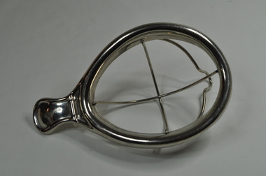
Anaesthetic Mask
This Anaesthetic Mask 'Schimmelbusch' mask was used to deliver chloroform or ether as an anaesthetic. When this mask was in use most doctors would have delivered the anaesthetic themselves. During the 1940s and 1950s, some nurses may have played an active role in the delivery of anaesthetics, particularly in remote areas and during wartime or doctor shortages. This medical / hospital equipment was the latest available in the 1950s when the Tawonga District General Hospital was built specifically for the increase in population due to the Kiewa Hydro Scheme.Historical: Shows the development of scientific hospital equipment. Provenance: Used in the Tawonga District General Hospital which was remote and therefore required good equipment. Good condition and good interpretation capacity.Metal egg shaped frame with metal pieces crossing longitudinally and across with attached moveable metal piece that holds cloth in when closed and fits into open hollow egg shaped frame. At one end is a flat metal piece that would rest on the forehead. Usually used for children. To add cloth (gauze or muslin) with anaesthetic (chloroform or ether) open the mask and place the cloth onto the frame. It clipped on and the fluid then dripped onto the cloth. CHIRON GERMANY between handle and oval.hospital; tawonga; mt beauty; medical; nurse; medical instrument; face; anaesthetic. -
 Warrnambool and District Historical Society Inc.
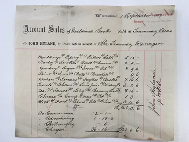
Docket, Hyland/ Tramways Sheds, Circa 1887
In 1858 a tramway was constructed to move goods between Warrnambool township and jetty on Lady Bay. It was established on the south side of Merri St in the approximate site of the present railway station. Large stores were also built near where the present rail lines to hold produce. This docket relates to unclaimed goods and range from tent poles, brooms, sugar scythes, lime juice tea, sauce, camp ovens and ale. John Hyland was the manager who was later mayor of Warrnambool. The Warrnambool tramway was an important part of transportation of goods in the 19th century from the port to the township which was over a mile away. White docket with some text printed in black with other sections handwritten in black pen. Dated September 1887. It shows a list of varied items. Signed John Hyland. “Account sales unclaimed goods by J Hyland Sep 1887” is in red pen on the back. warrnambool, warrnambool tramways, john hyland, unclaimed goods, -
 Warrnambool and District Historical Society Inc.
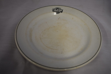
Plate, Commercial Hotel W'bool, 1920s or 1930s
This plate comes from the Commercial Hotel in Warrnambool. This hotel, situated on the north west corner of Liebig and Timor Streets, Warrnambool, was established in 1865. It was built by Thomas Mickle and the first licensee was Charles Anderson. From 1928 on the O’Dwyer family was associated with the Commercial Hotel, either as licensees or owners, for fifty years. The plate would have been first used during the times when Patrick O’Dwyer was the licensee – 1928-1931 and 1932 to 1934. Today the Commercial Hotel still trades as the Whalers Hotel.This plate is of interest as it is a memento of the 1920s and 30s when Patrick O’Dwyer was the licensee of the Commercial Hotel. This hotel, trading today as the Whalers Hotel, is the oldest hotel in Warrnambool and a prominent landmark in the city. This is a white china plate (dinner plate size) with the inner section slightly recessed. The plate has a black line around the outer rim and initials and a hotel name in a scroll pattern on one outer edge. The names of the maker and supplier are on the base of the plate and the top of the plate is somewhat stained. ‘P O’D Commercial Hotel Warrnambool’ ‘Made expressly for John Dynon and Sons, Melbourne Vitrified Globe Pottery Co. Ltd Cobridge England’ commercial hotel / whalers hotel, warrnambool, history of warrnambool -
 Warrnambool and District Historical Society Inc.
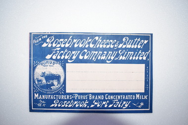
Label, Rosebrook Cheese and Butter Factory, Early 20th century
The Rosebrook Cheese and Butter Factory was opened in November 1888 by Messrs Lydiard &T F Rutledge & was a cooperative factory managed by Mr. Goldie. It operated out of the former Rosebrook Flour Mill which was built on the banks of the Moyne River near the Rosebrook bridge in the late 1840s. In 1896 the factory commenced the production of the condensation of milk. The company closed in 1911. The building and machinery were sold in 1917. Rosebrook is situated about 20 kilometres from Warrnambool on the Princes Highway. This label is of some local significance as the Rosebrook Cheese and Butter factory operated for 30 years Rectangular dark blue and white label featuring text and a trade mark. The latter is circular with three cows pictured. There are decorations of flowers and leaves. The central area of the label is white with three lines. The label is adhered to a piece of pink card.FROM THE Rosebrook Cheese & Butter Factory Company Limited, MANUFACTURERS OF "PURUS BRAND CONCENTRATED MILK Rosebrook, Port Fairy. "PURUS" TRADE MARK FOR CONCENTRATED MILKrosebrook, cheese and butter, concentrated milk, lydiard, rosebrook butter factory -
 Warrnambool and District Historical Society Inc.
Badges, Manchester Unity, Mid 20th century
The MU on these badges stands for Manchester Unity Independent Order of Oddfellows. This was one of the most prominent of the benefit societies operating in Warrnambool over the years. Originating in England, Manchester Unity I.O.O.F. was established in Warrnambool in 1860. This benefit society built and opened the Oddfellows Hall in Koroit Street Warrnambool in 1869 (building still extant but now used for office space). Some years ago the Manchester Unity I. O.O.F. joined with the Australian Natives Association to form a new benefit group, Australia Unity. These badges are of interest as mementoes of a benefit society that was prominent in Warrnambool for over 100 years..1 A round metal lapel badge with gilt edging, an outer blue band and the letters ‘MU’ in blue and red on a gold-coloured background. The stud clip is at the back. .2 As above except that it has a long stick pin attached to the back instead of a stud. MUmanchester unity independent order of oddfellows, benefit societies in warrnambool, history of warrnambool -
 Eltham District Historical Society Inc
Audio - Audio Recording, Jim Connor; Maroondah Aqueduct, 11 Jun 2022
This significant historical link in Melbourne’s water supply system is perhaps something we have taken for granted, or not even really noticed…it is just there! Built between 1886 and 1891 to transfer water from the Watts River near Healesville to the reservoir at Preston this aqueduct was 66 km in length and included open channels, tunnels and the use of inverted siphons to keep water flowing, to eventually service Melbourne and suburbs. At this meeting Jim Connor will talk about the challenges and achievements involved with this extraordinary project.1:09:10 duration Digital MP3 file; 23.7 MBaudio recording, eltham district historical society, meeting, society meeting, eltham, jim connor, maroondah aqueduct -
 Glen Eira Historical Society
Document - PRENTICE STREET, 59, ELSTERNWICK
Two items about this property: 1/Caulfield Conservation study by Andrew Ward, dated September 1994. His description of the villa is brief, he includes a small history of the street and ownership/tenants from 1885 to 1924. 2/Newspaper advertisement on newly built Elyse at 59 Prentice Street, Elsternwick. Details modern features of home and the incorporation of Edwardian style as well. Dated 16/03/2002 and includes 2 coloured interior and 1 colour exterior photographs.prentice street, victorian style, fitzmonnie leonora, ward andrew, elsternwick, timber houses, manson emmert, bricklayers, buxtons, corrugated iron, kooyong road, tiles, 'elyse', edwardian style, estate agents, verandah, fitzmonnie henry, newsagents, lowe s andrew, architectural features, fitzmonnie john, elliott william, elliott marc -
Glen Eira Historical Society
Letter - Edenhope, Caulfield North
A typed letter from Edenhope and District Historical Society Incorporated about Edenhope in Alma Road, St Kilda and possible owned by Georg Langford. A copy of photograph of the house Edenhope Caulfield taken in about 1870 by William Tibbits is included. Also included is a copy of an undated typed letter from Glen Eira Historical Society indicating that the society had no information about Edenhope or George Langford only another Langford and architect who built Merrimo in Dandenong Roadedenhope, alma rd, merrimu, dandenong road, orrong road, caulfield north, langford george, thomas george, tibbits william, wilmoth joseph, glen eira historical society, dunbar margaret, st kilda east -
Glen Eira Historical Society
Document - Riddell Parade, 48, Elsternwick
Two items about this property: 1/A typed Research report on the history of the property at 48 Riddell Parade, Elsternwick, built in 1916/1917 on a subdivision of John Carre Riddell’s land. Prepared by Hilary Bullock and Rosalind Landells of the Brighton Historical Society, dated 14/08/1992. Includes a list of past owners and residents of the property. Their handwritten working notes, undated, are also included. 2/A plan of the subdivision of Riddell Estate from Sand Swamp and Heath (photocopy).cavers carre, riddell john carre, elsternwick, riddell parade, weedon james, walker alice o mrs, foley christina mrs, foley aileen c dr, 'carmel', house names, mcmillan archibald, mcmillan street, 'sand swamp and heath', carre street, gisborne street, landells rosalind, bullock hilary -
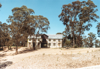
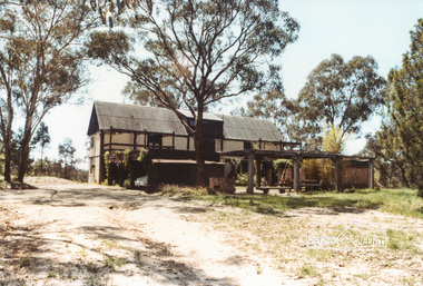
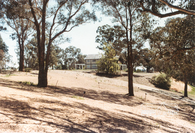
 Eltham District Historical Society Inc
Photograph, The Jelbart Barn, 93 Arthur Street, Eltham, 1972c
Owned at the time by architect, Ian Jelbart, the property had been in the Jelbart family since the 1940s; a 5560sqm secluded hilltop parcel in Eltham. When the manor house and its barn were built, Eltham was a rural community; Jelbart’s grandfather Ronald was a businessman whose poultry farm formed part of the family’s original 100ha holding. A portion would later be subdivided into residential lots to make way for new homes that would form the basis of the Woodridge Estate in the early 1970s.Digital file only; created from scan undertaken by EDHSarthur street, eltham, houses, jelbart barn, jelbart property, kinloch gardens -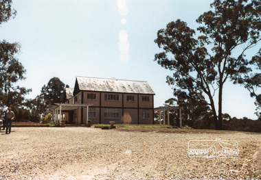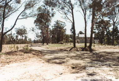
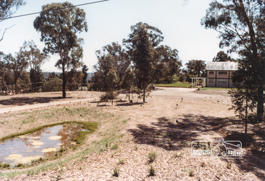
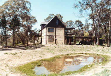
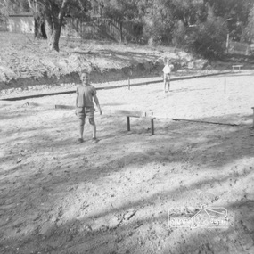 Eltham District Historical Society Inc
Work on paper (item) - Photograph, 2 Metery Road, Eltham South
Robert and Ada Zull built an Alistair Knox designed house at 2 (lot 8) Metery Road, Eltham, a one acre property for their family of five in the mid 1960s. The form of the house is laid out on the cleared block. There was a dam at the bottom of the block. Susan Bennett, nee Zull's reminiscences are published in EDHS Newsletter, February and April 2020. ".. the block was big.. Building the house was slow going. The plans had to be discussed, then drawn up, finance found, council permits obtained and labourers engaged. " This series of photographs together with the account of personal remiscences provide a unique document of the construction of an Alistair Knox designed home. Knox was a pioneer in the use of mudbricks and recycled materials and is significant to his contribution of this style of architecture in Eltham and the wider Shire of Nillumbik.zull family, clearing, eltham south, 2 metery road, alistair knox, bow and arrow -
 Eltham District Historical Society Inc
Work on paper (item) - Photograph, 2 Metery Road, Eltham South
Robert and Ada Zull built an Alistair Knox designed house at 2 (lot 8) Metery Road, Eltham, a one acre property for their family of five in the mid 1960s. Concrete footings are poured. The house had a concrete floor. Susan Bennett, nee Zull's reminiscences are published in EDHS Newsletter, February and April 2020. ".. the block was big.. Building the house was slow going. The plans had to be discussed, then drawn up, finance found, council permits obtained and labourers engaged. " This series of photographs together with the account of personal remiscences provide a unique document of the construction of an Alistair Knox designed home. Knox was a pioneer in the use of mudbricks and recycled materials and is significant to his contribution of this style of architecture in Eltham and the wider Shire of Nillumbik.zull family, eltham south, 2 metery road, alistair knox, bow and arrow, footings, concrete, concrete mixer -
 Phillip Island and District Historical Society Inc.
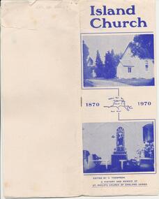
Pamphlet, St Philip's Anclican Church Centenary 1870-1970, 1970
The first church services were held at the McHaffie home in Ventnor once a fornight, the Preacher coming over in a whaleboat from the mainland. Land was reserved for the Church in 1869 and the first services were held in the new church in 1870. The Parish Hall was built in 1935. The short history in the pamphlet was based on material collected from Minute Books, Preachers' Books, Registers of Services, Documents and memories of those who have been closely associated with the Church over many years.A pamphlet produced by the St Philips Church of England for the Centenary - 1870 - 1970. A short history of the church is recorded in the pamphlet starting in 1864 when services were held at the McHaffie family home in Ventnor.st philip's church of england phillip island, cowes anglican church phillip island, alice robinson -
 Mission to Seafarers Victoria
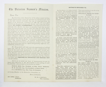
Letter - Printed circular or letter, The Victorian Seamen's Mission, c. 1902
Composed and signed by WHC Darvall on the executive of the Victorian Mission to Seamen also with reference to three other officers: Mr Reid-President, Mr Allard Vice President, Mr Seymour Hon Treasurer. Darvall returned to Melbourne late 1901 early 1902. A former solicitor Darvall and the Mission Committee are concerned it seems at the 'appropriation' by other organisations of donations or funds usually promised to the VMTS. The seamen's home was being built or about to be on the site of the World Trade centre on Siddeley St. as at 2020. This letter was sent out at a pivotal period in the Mission story soon after the sudden death of Rev James after 20 constant years service, with the proposed arrival of a Seamen's home on Siddeley St to a location close by to one long sought by the Victorian Mission for their first Central Mission and just a few years before arrival of the London Mission to Seamen representative Rev A Gurney-Goldsmith. The ladies Committee of the Mission and volunteers had prior to appointment of a paid collector had done most of the collecting of donations.A 2 page printed circular or letter addressed to Dear Sir alerting the recipient to the new appointment of a paid Collector, Mr L Dangerfield, visiting supporters authorised to collect donations and subscriptions and not to be confused with other similarly named groups such as the Seamen's home. The pamphlet also includes extracts from a speech by "His Excellency the Governor" reminding the recipient of the authentic goals of the Mission which also, as ever, were essential to business interests in supporting seafarers.paid collector, mr l. dangerfield, whc darvall, rev james, rev geary -
 Seaworks Maritime Museum
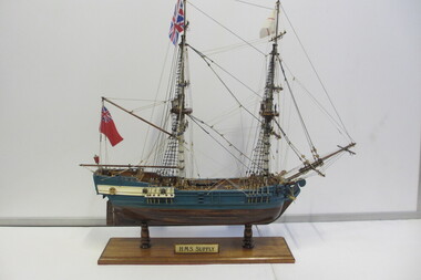
Model Ship, HMS Supply
The supply was the smallest of the fleet being only 170 tons and 70 feet long. Carrying 50 people and skippered by Captain Henry Bull, she led the fleet most of the way primarily because of her speed. Little is known of this brig's early history, but it seems she was built in America in 1759 and was commissioned by the Admiralty in October 1786. The Supply returned to England where she was renamed the Thomas & Nancy. The ship seems to have carried coal on the Thames until around 1806. Model of the HMS Supply -
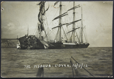 Mission to Seafarers Victoria
Postcard, The Pisagua, Dover, 16 March 1912
The Pisagua was a four-masted barque built in 1892 at Geestemünde, Germany. In 1901, Pisagua sailed from Lizard point to Port Pirie in 79 days. On March 12th 1912 she collided with the P&O steamship Oceana in Sussex. Pisagua was towed to Dover, Kent for repairs. The Oceana sank. P&O sued the Pisagua owners but judgment using the 'steam gives way to sail' obligation/rule found the Oceana to be at fault. The Pisagua never sailed again and was converted into a whale factory.... -
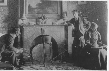 Greensborough Historical Society
Photograph - Digital image, Saxam interior, 1896_
'Saxam' was the home of the Kaye family (1886-1888) then William Santon, a former councillor and Mayor of Heidelberg. Saxam Homestead is a distinctive and substantial timber homestead built in the late 1880s as one of the notable rural properties in the St Helena area. [Photo G. Studley]. Seated are Mr and Mrs Kaye, standing William Santon who was a local footballer, councillor and later Mayor of Heidelberg. In 2014 the house still stands but is in poor condition with most interior features such as this fireplace removed. Digital copy of black and white photograph.saxam, william santon, santon family -
![Photograph - Digital image, Iredale Family 1 [man and woman], 1890c](/media/collectors/4f729f5697f83e03086015b8/items/5455cc332162f10d64fa5bbd/item-media/5455cc5f2162f10d64fa6013/item-fit-380x285.jpg) Greensborough Historical Society
Greensborough Historical SocietyPhotograph - Digital image, Iredale Family 1 [man and woman], 1890c
Photograph of members of the Iredale family - George Iredale and Anna Marie [nee Gilding]. In 1858, James Iredale owned the General Store in Main Street Greensborough, when it became the Town’s Post Office. The Farmers Arms Hotel was built on the corner of Main and Hailes Street in 1864 by George Iredale to cater for the ever increasing number of wood carters and other hauliers carting their wares between Melbourne, timber mills and the gold fields. The Farmers Arms Hotel is currently the site of the Greensborough Hotel. Digital copy of black and white studio photograph.james iredale, george iredale, farmers arms hotel -
![Photograph - Digital image, Willis Vale [3], 1878c](/media/collectors/4f729f5697f83e03086015b8/items/54fd5aeb2162f10d30c0aed5/item-media/54fd5b042162f10d30c0b12d/item-fit-380x285.jpg) Greensborough Historical Society
Greensborough Historical SocietyPhotograph - Digital image, Willis Vale [3], 1878c
Ellen and Charles Partington at Willis Vale: House built by Edward Maygar, Robert Whatmough lived there mid 19th century and later sold to Partington family. It was located on the Plenty River at Partington's Flat Greensborough. Land use included farming and orchards. The derelict Willis Vale house was destroyed in 1964 when a fire originating from North Plenty Gorge - Kurrak Road - was lit by two teenage boys and made its way several kilometres down to Partington's Flat Greensborough.Home of the Partington familyDigital copy of black and white photograph.charles partington, willis vale, ellen partington -
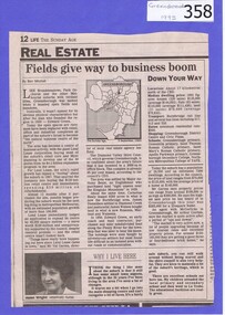 Greensborough Historical Society
Newspaper clipping, Fields give way to business boom, 1993_
Tells some of the story of the settlement of Greensborough and Lend Leases' gradual take over of Greensborough shopping area. In Canberra Times Wednesday 17 November 1993, page 27: Melbourne: Lend Lease Corp Ltd is to undertake a $600 million redevelopment of two suburban Melbourne shopping centres, at Dandenong and Greensborough; to be built in conjunction with Australia's largest retailer; Coles Myer Ltd. The project will create about 2000 jobs; 1000 during construction and 1000 in long-term retail.Has some history of Greensborough and records the average land prices in 1993. A black and white Sunday Age newspaper story. Includes map and photograph of resident.greensborough, lend lease, 1993, land prices -
Kiewa Valley Historical Society
Papers - History of the Shire of Bright taking over Mt Beauty from the State Electricity Commission of Victoria
Mt Beauty township was built as a construction town by the SECV for their workers on the Kiewa Hydro Electric Scheme. In Oct. 1957 the Bright Shire agreed to take over the running of the town At the time it was thought that the section of 'North Mt Beauty ' would disappear. By 1961 and again in 1975, the Shire was still struggling with money for administration and maintenance of the town, including the 'sub-standard' homes in North Mt Beauty. The papers state the agreements made over the years from 1957 to 1975 in order to come to a new agreement.Correspondence between the SEC and the Bright Shire in 1975 confirms that the Shire was struggling to maintain the high standard with increased costs, set by the SEC during construction. "Mt Beauty provides less income to the Shire and offers a poor medium for the reception of grants and CRB assistance'. The papers state the agreements made over the years from 1957 to 1975 with negotiations for a new agreement. This still seems to be a problem in 2021 - a second rate town compared to Bright which makes more money and gets more facilities.A variety of foolscap size papers bound by a rusty fastener. Includes letters re Municipal Administration of Mt Beauty township since the A few pages are hand written.mt beauty township, bright shire, municipal administration of mt beauty, alex mccullough -
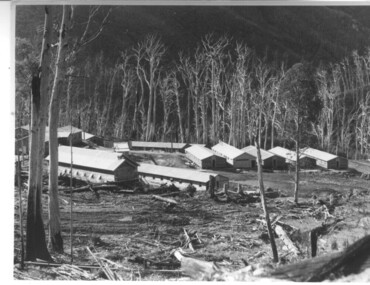 Kiewa Valley Historical Society
Photograph of Howmans Dam Camp, Howmans Dam Camp, circa 1948
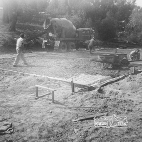
Howman's Gap camp was erected in 1948. The proposed dam to be built at this site was postponed in 1954 because of financial restraints imposed by the government at this time. It was to have supplied water for No. 2 Power Station at the Junction of the Pretty Valley and Rocky Valley branches of the East Kiewa River. This power station was not constructed until 2008 - 2010 and now gets it water from McKay Creek Power Station. The site of this camp is now occupied by the Howman's Gap Alpine Centre. Some of the original buildings still remain. An excellent photographic record of the type of buildings and size of the camp for accommodation of workmen during construction of the Kiewa Hydro Electric Scheme.Black and white photograph of the buildings erected at Howmans Dam site as accommodation for workmen.Handwritten in blue ink on the back of photograph "Howmans Dam Camp"howman's gap, camp, water, dam -
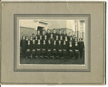 Orbost & District Historical Society
black and white photograph, Neville Huon, 1939
During 1910-11 the first approaches were made to the Department of Education for the establishment of a Higher Elementary School in Orbost and this became a reality in 1912. Orbost Higher Elementary School supplied post-primary education in the district until a high school was built in 1948. Higher Elementary schools took in students whose parents desired a higher level of education than the completion of Grade 6. Higher elementary classes were added to existing primary schools and were the forerunners of high schools. Orbost High School / Orbost Secondary College has played a significant part in the education of senior students in the Orbost district . It is the sole senior educational institution. This photograph is representative of its history.A black / white photograph mounted on grey card. it shows three rows of students and teachers in font of a brick building. They are dressed in uniforms with ties and blazers.on back - 1939 D & C FORMS Nance Gilbert front row 3rd from righteducation-orbost higher-elementary-school-orbost gilbert-nance -
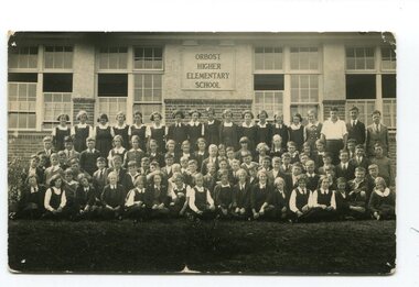 Orbost & District Historical Society
black and white photograph, Geehan, N.R, 1937
During 1910-11 the first approaches were made to the Department of Education for the establishment of a Higher Elementary School in Orbost and this became a reality in 1912. Orbost Higher Elementary School supplied post-primary education in the district until a high school was built in 1948. Higher Elementary schools took in students whose parents desired a higher level of education than the completion of Grade 6. Higher elementary classes were added to existing primary schools and were the forerunners of high schools.Orbost High School / Orbost Secondary College has played a significant part in the education of senior students in the Orbost district . It is the sole senior educational institution. This photograph is representative of its history.A black . white photograph of a large group of students in uniform in front of a school building - "Orbost Higher Elementary school". There are four rows of students.on back - M. Gilbert