Showing 1016 items matching "document - title"
-
 Bendigo Military Museum
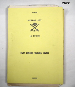
Document - TRAINING NOTES - ARMY, AUSTRALIAN ARMY, Staff Officer's Training Course
Notes related to 3rd Division Staff Officers Training Course. Date range 1972-73. Part of the "Kevin John Herdman" No. 397661 collection. See Cat No. 5942P for details of his service.Yellow covered card folder containing pages secured with a metal fastener. Front of folder has title in black type, Australian Army 3rd Division logo located on top half of cover. Internal pages vary in size from foolscap to A4. Text on printed pages in black type. Handwritten pages in blue ink. Notation on first page handwritten in pencil.training notes, 3rd division staff officers, army, kevin john herdman -
 Bendigo Military Museum
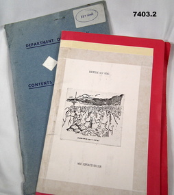
Document - TRAINING NOTES, Australian Army, Exercise Key Ring - War Administration, April 1984, May 1988
Training notes related to "Exercise Key Ring" - War Administration. Printed notes are dated April 84 and May 88. Part off the "Kevin John HERDMAN" No.397661, collection. See Catalogue No. 5942P for details of his service record.1. Red and cream coloured foolscap sized manilla folder containing green and pink coloured pages with text in black type. Pages have two punched holes and are secured in place with a silver coloured fastener. Title on front cover in black type. Black and white illustration with caption also on front cover. 2. Light blue coloured foolscap sized manila folder containing white pages with printing in black text and fastened on top LH corner with a staple. Remaining lined pages contain handwritten notes in black, blue and pencil. All pages are labelled “Restricted”. Title on front cover is dark blue type. Front and rear covers have three diamond shaped holes cut into them.1. Handwritten in pencil inside back cover: "Class1. Rat, 3, POL, 4. Def Hom, 5. Ammo/min” 2. Handwritten in blue on a white sticker on front covers: “Key Ring”.training notes, exercise key ring, war administration, kevin john herdman -
 Bendigo Military Museum
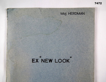
Document - TRAINING NOTES, Exercise 'New Look"
Training notes developed by Major K. J. Herdman for Exercise “New Look”conducted during 1977. Part of the Kevin John Herdman, No. 397661, Collection. See Catalogue No. 5942P for details of his service record.Light blue coloured foolscap sized manila folder containing pages of text printed in black type. Pages are secured with a metal adjustable clasp. Title on front cover in black type.Printed on front cover: “EX "NEW LOOK", Maj HERDMAN”.training noted, exercise new look, kevin john herdman, tactics -
 Bendigo Military Museum
Album - COLLECTION of LETTERS & PHOTOGRAPHS, c. 1935 to 2000
Display book contains Ian A. Lyons' citation for his MBE, letters of reference, personal letters, photographs, newspaper articles and biogrphical information. Part of Flight Lieutenant Ian A. 'Joe' Lyons MBE Collection. See Catalogue No. 5374P for details of his service record.Green covered display book with forty pages. Book contains a collection of letters, documents, photographs and newspaper clippings. Black and white photograph of a man in RAAF uniform on page one.Title on page one: 'Flight Lieutenant Ian A. 'Joe ' Lyons'.ian a. 'joe' lyons, letters, photograph, mbe citation -
 Bendigo Military Museum
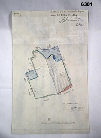
Plan - Victorian Titles Office - Fortuna Lot Plan, Victorian Titles Office, 3 Dec 1975
Title plan of Fortuna property depicting the initial acquisition in 1951 plus additional areas acquired during 1955 and 1957. The accompanying notes show details of the acquisitions, when they occurred and the costs. The plan is foolscap in size whilst the Notes are a single smaller sheet. Includes one foolscap size page, probably part of a larger (more page) document.Title plan of Fortuna property depicting the initial acquisition in 1951 plus additional areas acquired during 1955 and 1957. The accompanying notes show details of the acquisitions, when they occurred and the costs. The plan is foolscap in size whilst the Notes are a single smaller sheet.Top right hand corner - "Certificate of Title entered in the Register Book Vol. 8159 Fol. 690, Signature Illegible, Assistant Registrar of Titles". Towards the bottom right hand corner - "No ENDOURSEMENTS (some unreadable Signatures) H.D. Draper 24.11.75, R.B? 26.11.75, ? 3.12.75. Near bottom of Page - Initials?" "THE MEASUREMENTS ARE IN LINKS"royal australian survey corps, rasvy, fortuna, army survey regiment, army svy regt, asr -
 Warrnambool and District Historical Society Inc.
Document, Accounts, Early and Middle 20th Century
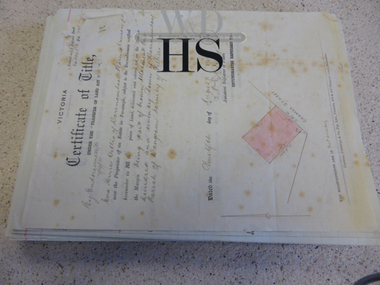
These pages of accounts are from the firm of Mackay Taylor, Lawyers, a prominent firm in Warrnambool for over 100 years. The Warrnambool legal businesses of George Mackay and James Fletcher merged in 1893 and was known as Fletcher and Mackay. In the 1920s Mr Mackay took J. McD Taylor as a partner and the premises at 131 Kepler Street were built about that time, with the firm being known as Mackay and Taylor. After the original partners died there was a succession of partners with the legal firm continuing as Mackay Taylor until the 1990s. These account sheets from a prominent 20th century legal firm in Warrnambool are of considerable importance as they document the legal records of many Warrnambool and district personalities from the early 20th century. The information contained in the sheets will therefore add to the known history of many local people from the past and will be very useful to researchers.These are handwritten accounts for bills to be paid to Mackay Taylor Lawyers for services rendered. The accounts are described in detail and are written on quarto size paper with the requisite red lines already printed on the pages. There are over 100 sheets and they date from 1938 to 1940. There are also two original Certificates of Title for Eva Willis (1916, portion of land in Cramer Street) and Archie Jackson (1924, portion of land in Cramer Street). warrnambool, warrnambool lawyers -
 Warrnambool and District Historical Society Inc.
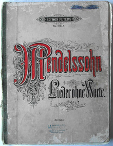
Document - Music Folio, Mendelsshon Lieder ohne Worte, Circa 1900
This collection of works, “songs without words” was written in the 1830’s by Mendellson. He was of the opinion that the music should stand alone and hence no need for words. This collection of his work for piano solos is still on the music syllabus today. The stamp on the front cover J.B. Shepherd and Son relates the Shepherd family music store in Liebig Street, which operated around the turn of the 20th century . They sold pianos and other musical instruments as well as doing repairs and tuning and lessons.This collection of music scores by Mendelssohn is significant firstly because it is still used by music students 160 years after it was written and secondly this copy has local significance as it was owned by Grace Rome who was born in 1902 and was the daughter of one of Warrnambool’s most successful and longest living business people Thomas Rome, who incidently made one of the earliest sound recordings in Australia.Cream coloured card cover with dark green cloth binding with the title Mendelssohn in red text with black flourish. Other text on cover is black. Edition Peters at the top of cover in black text. Pages contain music scores .132 pages. Kullak printed on front cover. Light blue stamp, “J. E. Shepherd & Son, Piano, organ & music Warehouse. Tuners & repairers Warrnambool. Written in Black ink but scrubbed out with blue ink on inside fly is Grace Rome P.L.C. 1921. 1. Similarly un unknown name is scrubbed on front top right corner of cover. warrnambool, mendelssohn, lieder ohne worte, edition peters, grace rome -
 Warrnambool and District Historical Society Inc.
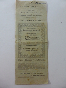
Book, Original document Concert W Town Hall show Night, 1902
This is a programme of a concert called ‘The All Nations Night’ staged by the Warrnambool Orchestral Society and held in the Warrnambool Town Hall on Show Night, November 13th 1902. The conductor was Louis Bayer (1857-1907). Born in Germany, Bayer came to Warrnambool in 1891 and with his wife taught piano, violin, orchestration and singing and established the Warrnambool Orchestral Society. In 1896-7 Louis Bayer was the musical director at the Warrnambool Industrial and Art Exhibition, writing the Cantata for the opening ceremony and directing over 60 performances, including 22 operas and many concerts. Bayer was a composer and wrote several operas including one called ‘Federation’. Bayer’s wife was an accompaniste at this ‘All Nations Night’ concert and his son, Otto was the horn player. The concert featured the soloists, Nellie McClelland, Lucy Meares, W.D. Thomson and D. Williams. The concert may have been sponsored by Youngers Stores. This large department store was established in 1888 and closed in the 1980s. This programme is of great significance as it featured a 1902 concert conducted by Louis Bayer, one of the most important musical identities in Warrnambool’s history. These are two sheets of green-coloured paper folded in two to make eight pages. The printed material is in black type. The pages include the concert programme, a list of members of the orchestra and several advertisements for Youngers Stores. The front page has the concert title (‘The All Nations Night’) in a text box bordered by a floral pattern. The pages are a little torn at the edges. younger & co, warrnambool, history of warrnambool, louis bayer -
 Kiewa Valley Historical Society
Papers - History of Mt Beauty Football Club 1974
Ian McKendrick was secretary of the Mt Beauty Football Club on 8th Aug. 1974. He compiled important papers re the club's history and stored them in an envelope for future reference and preservation with the idea of each secretary passing the envelope on to the next secretary.Mt Beauty football club was formed at a meeting on 19th Sept. 1974 attended by Bogong Tawonga Football club when the club changed its name. The Mt Beauty football club has since amalgamated with the Dederang football club. List of footballers in 1975 is helpful for researching local families living in the Kiewa Valley. An envelope titled 'Notice to Secretary' and 'List of Documents'. Enclosed 15 pages comprising of 1. Newspaper cuttings, 2.Typed pages with the title - 'Recreation Reserve pavilion - Mt Beauty', 3. Typed page title 'Mt Beauty Recreation Reserve Drainage', 4. Plan of Mt Beauty Recreation Reserve pavilion sketch 1975, 5. Handwrittten page title re P. O'Brien Years of Association 1950 - 1974 and names of teams on the back.. There is more than one copy of some pages. 1970smt beauty football club, ian mckendrick, bogong tawonga football club -
 Warrnambool and District Historical Society Inc.
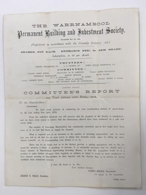
Balance Sheet, Warrnambool Permanent Building and Investment Society 1872, 1872
The Warrnambool permanent Building and Investment Society was established in May 1869. It relied on investors buying shares in the society, thereby providing the funds which were available to be borrowed to use in the building of houses. A considerable number of houses in Warrnambool would have been built using this scheme. The stated trustees in 1872 were Samuel Macgregor, C A Cramer, James Astley Bromfield, and the committee comprised of James Hider, W. W. Jamieson, James Coulstock, Archibald MacFarlane, Robert Newton, David Evans, NT C Stelling and W Jones. The bankers were the national Bank of Australasia. It had some difficulties in the 1870’s but was still operating well into the 1930’s where it again was not putting through the volume of business compatible with its resources and it had been found necessary to pay off a considerable number of fixed deposits and Investors’ shares. There is little mention of it after the mid 1930’s. This document provides details of an organization which operated in Warrnambool for over 60 years and proved beneficial to homebuilders and investors alike. It also has a number of well- known local names listed in their positions of operating the building society.Cream watermarked paper folded to four pages. Title on front cover with letter to shareholders printed below for the year ending 30th April 1872. Page three has balance sheet of the Warrnambool Permanent Building & investment Society. Second and fourth pages are blank. Signed in print by James Hider President, Henry T Read secretary.warrnambool permanent building and investment society, warrnambool, warrnambool 1872, -
 Warrnambool and District Historical Society Inc.
Administrative record - Cine Club Minute Books, Office Bearers of the Warrnambool and District Amateur Cine Society/ Warrnambool Movie Club, Warrnambool and District Amateur Cine Society, 1950s to 1980s
These two minute books document the activities of the Warrnambool and District Amateur Cine Society from its formation in 1954 to 1981. In January 1968 it changed its title to Warrnambool Movie Club. In the 1960s the Society made films of the Florado festivals and in 1960 the Florado film was viewed by more than 3000 people when it was screened at the Liberty Theatre, Warrnambool.These minute books are of considerable interest as the Warrnambool Cine Society was very active in the second half of the 20'th Century. We now hold some of the films they made and these are historically important..1 This is a hard cover ledger with a label on the front cover. The pages have printed red lines and typed and hand written text. There are many loose pages and inserted material. The linen spine is damaged and partly detached. .2 This is a hard cover ledger with a dark blue cover with the maker's emblem on it. The pages contain typed material and there are several loose pages, some hand written. A black and white photograph is pasted inside the back cover.warrnambool cine club, warrnambool movie club -
 Warrnambool and District Historical Society Inc.
Document - Documents (3) of Farnham Cheese and Butter factory, 1890s (originals)
... showing a Certificate of Title (copy) Document Documents (3 ...These three sheets are copies of the originals and relate to the establishment of the Farnham Cheese and Butter Factory in Dennington (Warrnambool). The name 'Farnham' is the name of the Special Survey in the area first purchased by William Rutledge and also the name of the Rutledge property at Dennington. In 1889 WIlliam Rutledge (Junior) and Thomas Palmer established the Farnham Cheese and Butter Factory on the banks of the Merri River at Dennington. In 1890 they sold the factory to a farmers' co-operative. Farnham had a high reputationfor butter=making when the factory was in existence. The factory was bought out by Nestles about 1909 with that company establishing its factory on the same area.in 1911. These documents are of interest as the Farnham Cheese and Butter Factory was one of the earliest of its type in the Western District and won a Gold Medal in 1909 for butter-making at the Islington Dairy Show in competition with other butter-making countries in the world..1 sheet of paper with black and white map showing location of factory in Dennington (copy) .2 An A3 size piece of paper with a sketch map and typed material showing a Certificate of Title (copy) .3 An 3 size piece of paper with a sketch map and typed material showing a Certificate of Title (copy)farnham cheese and butter factory, nestles factory warrnambool -
 Warrnambool and District Historical Society Inc.
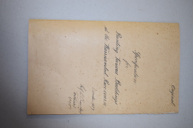
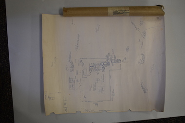
Documents, Rolf Crawley, Warrnambool, Warrnambool Race Course, 1920s and 30s
These documents deal with improvements in the 1920s and 30s (drainage, painting etc) to the Warrnambool Race Course. In 1854 the Warrnambool Racing Club was established and the first race meeting on the present day Warrnambool Race Course was held in 1858. These documents came from the office of Rolf Crawley, an engineer, architect and surveyor in private practice in Warrnambool and the engineer for the Shire of Warrnambool from 1935 to 1968. His grandfather, father and uncle were also engineers and worked in that capacity or as the Shire Secretary for the Shire of Warrnambool, with the Crawley family recording a total of 132 years of service to the Shire. The Shire of Warrnambool existed from 1863 to 1994. The documents came into the possession of Michael Hand who had taken over the private surveying business of Rolf Crawley in Warrnambool. The Warrnambool and District Historical Society acquired these documents and other Crawley material, from the Michael Hand estate. These documents are of considerable interest as they concern the Warrnambool Race Course improvements in the 1920s and 30s and come from the office of Rolf Crawley of Warrnambool. These are seven documents relating to the Warrnambool Race Course: .1 A manila folder with a handwritten title on the front cover and typed and printed material inside .2 A sketch map of the Warrnambool Race Course produced on heavy quality white paper. .3 Hand-drawn material on the underground drains on the Warrnambool Race Course produced on heavy quality white paper .4 & .5 Longitudinal section of the main drain, Warrnambool Race Course, produced on heavy quality white paper .6 Section of the drain near the fence and culvert of the Warrnambool Race Course produced on heavy quality paper .7 A piece of paper giving the chainage of the Warrnambool Race Course in red handwriting. warrnambool race course, rolf crawley, warrnambool -
 Warrnambool and District Historical Society Inc.
Document (Sketch Plan of Dunmore), Stan Baulch, 1972
... and the cover have handwritten titles in ink. Document (Sketch Plan ...This card has a sketch map showing the properties surrounding Dunmore on one side and a detailed sketch plan of Dunmore homestead in the early 1970s on the other side. The plan of Dunmore homestead shows interesting features such as the brick oven for bread making, the croquet lawn, the site of the aboriginal mia mias, the Turkish baths and the fowl house used later as a poison house. Francis and Ann Baulch were pioneer settlers in the Kirkstall area and their son Samuel worked at Dunmore in the Macarthur area before purchasing in the early 1870s the property he named Rose Park. In the 1890s he acquired property in the Dunmore estate and his son Stan Baulch gained a section of the Dunmore property after his father’s death. Stan Baulch named this Dunmore section, Rose Park, a property to the west of his father’s original Rose Park property. Stan Baulch was a long time member of the Warrnambool & District Historical Society and he contributed many local history articles and donated many local artefacts to the Society.This sketch plan is of interest as it tells us what the historic homestead of Dunmore in Western Victoria was like in the early 1970s. It will be useful for research. This is a sheet of white lightweight cardboard with a pencilled sketch on one side and a blue ink sketch plan of a house on the other side. The edges of the card have some torn sections. The card is enclosed in an oval cardboard cylinder (recycled and torn at the ends). Both the card and the cover have handwritten titles in ink. Dunmore Homestead & History by S. Baulch Dunmore Homestead drawn by Stan Baulch c.1972 dunmore property, western victoria, baulch family -
 Warrnambool and District Historical Society Inc.
Documents, Late 20th, early 21st centuries
These ten documents (maps, plans, photographs) mostly come from the Warrnambool City Council and most contain information on sub-divisions and titles of properties in areas around the Central Business District of Warrnambool. The dates range from 1986 to 2006. These maps, plans and photographs are of some interest as they give historical details of subdivisions in Warrnambool and date from the late 20th century. .1 This is a laminated map of the boundaries of Local Governments in Victoria. It is Sheet I of 2 and has red and blue pencil markings and black boundary markings. .2 This is a copy of a plan of a survey in black and white markings on paper. .3 This is a plan of the title details of Section 19 Warrnambool. It has black printing on buff-coloured paper. .4 This is a plan of the allotments in part of the Central Business District of Warrnambool. It is printed in black and white. .5 This is a 2006 coloured aerial photograph of the harbour at Warrnambool – Breakwater etc. .6 This is a 2006 coloured aerial photograph of the Lake Pertobe area in Warrnambool .7 This is a coloured aerial photograph of Warrnambool’s streets over-stamped with road numbers in large blockings. .8 This is a plan showing the title details of Section 11 in Warrnambool. It has black printing on buff-coloured paper. .9.1 This is a plan of sub-divisions in parts of Crown Allotments 38 & 39 in Warrnambool. It has green, pink and yellow markings with black printing. .9.2 This is a plan of the sub-divisions in parts of Allotments 38 & 39 in Warrnambool. It has pink, yellow and blue markings with black printing. It is somewhat faded. warrnambool c.b.d. maps and plans, history of warrnambool -
 Warrnambool and District Historical Society Inc.
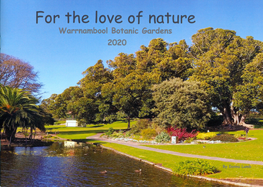
Book - Children's book, For the love of nature: Warrnambool Botanic Gardens 2020
This children's book was produced to document the construction of the Nature Play Space in Warrnambool Botanic Gardens in 2020. It tells the story of what great community spirit, persistence and excellent teamwork can achieve; a nature play space for all to enjoy. The project was funded by the Victorian Government's 'Pick my Project' initiative and overseen by the Friends of Warrnambool Botanic Gardens in conjunction with the Botanic Gardens team and Warrnambool City Council.This book is significant as it documents the construction of the nature play space in Warrnambool Botanic Gardens. It is one of few locally produced children's books.Soft cover book with image of Warrnambool Botanic Gardens which wraps around to the back cover. The image shows the lake with children feeding ducks and trees in autumn colours.The title text is black and sub-title and author's name in grey.children's literature, garden construction, children's playgrounds -
 Eltham District Historical Society Inc
Document - Property Binder, 60 Kent Hughes Road, Eltham
1. Certificate of Title of Lot 22 on Plan of Subdivision No. 7894 and other material pertaining to Mary Frances Carrucan (nee Sweeney) and family connections (Digital file only)eltham, 60 kent hughes road, certificate of title, mary frances carrucan (nee sweeney) -
 Eltham District Historical Society Inc
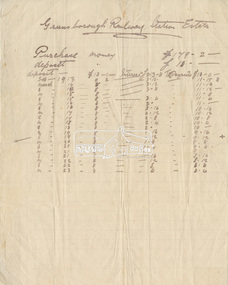
Document - Folder, Greensborough Railway Station Estate, Lots 26, 26A and 26B, Crown Portion 3, Parish of Nillumbik, County of Evelyn (Rattray Road, Montmorency)
Crown Portion 3 of Eltham, Parish of Nillumbik, County of Evelyn, Lots 26, 26A and 26B were part of the Greensborough Railway Station Estate. The land detailed is bounded by present-day Rattray Road, Reichelt Avenue, Wooded Way and Ryrie Court, Montmorency. Originally purchased in September 1913 by George William Miller, signwriter of Greensborough and Harry Frederick Miller, the land was sold to Mrs Margaret Barr Honeyman, 24 June 1918 on mortgage for £400, deposit paid £150. In February 1920, Mr Honeyman called for the title and paid off the loan early, settlement occuring 11 October 1920. Contents: 1. Handwritten payment plan (Sep 1913 to Mar 1923) for Lots 26, 26A and 26B being parts of Crown Portion 3, Parish of Nillumbik, County of Evelyn on the plan of subdivision making up the Greensborough Railway Station Estate situated on Rattray Road; purchased for £179.2.0 with a deposit of £18.0.0. 2. Receipt: From Messrs G.W. and H.F. Miller for £11.15.8 being instalment and interest, 9 Sep 1913 3. Invoice: To Messrs G.W. and H.F. Miller for £11.12.0 being instalment and interest due 15 Sep 1914 4. Contract of Sale: George William Miller and Harry Frederick Miller to Mrs. Margaret Barr Honeyman, in respect of sale of Lots 26, 26A and 26B for £400.0.0, 24 June 1918. Deposit of £150.0.0 balance to be paid half yearly instalments of £15 with interest at 5% per annum added. 5. Letter: Percy J. Russell, Solicitor to G.W. Miller, 5 Feb 1920 advising Mr Honeyman has called for the title and wishes to pay off mortgage. 6. Letter: Percy J. Russell, Solicitor to G.W. Miller, 11 Oct 1920 advising settlement and payment of Miller to Honeyman.contract of sale, george william miller, greensborough railway station estate, harry frederick miller, land sale, margaret barr honeyman, montmorency, rattray road, reichelt avenue, ryrie court, wooded way -
 Eltham District Historical Society Inc
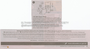
Document - Property Binder, 1307 Main Road, Eltham
Newspaper notice: Diamond Valley Leader, 31 January 2018, Calls for submissions re removal of reserve status and rezoning, Reserve 1 on Plan of Subdivision 213452R, Certificate of Title Volume 9879 Folio 829 and Reserve 2 on Plan of Subdivision 134133 Certificate of Title Volume 09434 Folio 620.main road, eltham, property -
 Eltham District Historical Society Inc
Document - Property Binder, 727 Main Road, Eltham
Copy Certificate of Title, plan of subdivision Part of Crown Portion 12 Section 4 Parish of Nillumbik County of Evelyn.main road, eltham, property, houses, shops, businesses -
 Eltham District Historical Society Inc
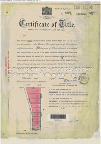
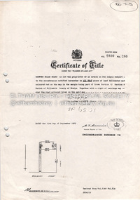
Document - Certificate of Title, Landata, Vol. 4930 Fol. 985900, Crown Portion 15 Section 5, Parish of Nillumbik, County of Evelyn, 1925
... of Nillumbik, County of Evelyn Document Certificate of Title Landata ...(Cancelled) Certificate of Title originally issued for Crown Portion 15, Section 5 to Robert David Taylor, of Eltham, County of Evelyn, Farmer, 13 March 1925. It is with this title that the land allotment was subdivided into 48 lots. The title shows the issuance to Robert David Taylor with encumbrance placed upon it by immediate former owner, Hugh Patrick Keogh, a former member for Gippsland and Melbourne Real Estate Agent. Following Taylor's death in 1934 the title passes to his Executors, sons Robert David Taylor of Bible Street, Eltham and William McLelland Vance Taylor of Northcote. The property is then sold to Frank Stokes who develops the Stokes Orchard. Compulsory acquisitions by the Melbourne Metropolitan Board of Works and State Electricity Commission show provisions of easemenst for town water supply and high voltage power transmission lines. Subsequent lots are then sold off with the development of the Stokes Orchard Estate residential development in the mid to late 1970s. A History of the Development of Crown Allotment 15, Section 5, Parish of Nillumbik – Stokes Orchard Crown Allotment 15, Section 5, Parish of Nillumbik (CA15) is a square allotment of 158 acres or approximately a quarter of a square mile. It lies just beyond the eastern end of Pitt Street, south of Nyora Road to the northern end of Eucalyptus Road and extends east from Eucalyptus Road to Reynolds Road. The topography of CA15 is generally steep, sloping up to a hill near the centre of the land, the ridgeline passing through the properties along the southern side of Diosma Road. Eucalyptus Road is a straight north-south road with its northern end at the north west corner of CA15. Until the end of the 1970s this road was an un-named Government Road and was largely not open to traffic. With residential development in the 1970s the road was constructed, and the council allocated the name obviously in recognition of the predominant species of the local bushland. CA15 was purchased from the Crown by George D’Arley Boursiquot, a prominent Melbourne printer, on 28th October 1852. On November 23, 1922, former Member for Gippsland and Melbourne Real Estate Agent, Hubert Patrick Keogh purchased the allotment then sold it March 13, 1925, to local farmer, Robert David Taylor, a former Shire of Eltham Councillor (1911-1920) and Shire President (1919). Taylor had extensive land holdings stretching west towards Bible Street and Main Road. The Taylor home was situated at the top of the hill in Bible Street at present day 82 Bible Street. At the time of Taylor’s purchase in 1925, CA15 was subdivided into 48 lots that could be described as small rural properties or large residential lots. A typical lot size was one hectare or 2.5 acres. The subdivision created two roads, Nyora Road, and Diosma Road, each following an irregular alignment between Eucalyptus and Reynolds Roads. However, the lots were not sold off separately nor were the roads constructed. The land effectively remained as one parcel for many further years. Robert David Taylor died November 30, 1934, and probate was granted to his son of the same name, Robert David Taylor of Bible Street, Salesman and William McLelland Vance Taylor of 73 Emmeline Street, Northcote, Clerk, with the transfer of the land into their names on July 8, 1935. Frank Stokes worked as a qualified accountant at Kennons leather factory in Burnley, while living at 1 Thomas Street, Mitcham. He suffered from migraines and wanted to return to working the land (he had previously worked on farms and orchards since coming to Australia from England in 1926, both in WA and Vic.). He first travelled to the district by train in July 1942 to find land with the intention to establish an orchard. By chance he met Arthur Bird of Bird Orchard (bounded by Pitt Street, Eucalyptus Road, and Wattle Grove) and they got talking over their common interest. Arthur put Frank up for the night and pointed out the land, 158 acres- part of the Taylor Estate- £900, Crown Allotment 15, Section 5, Parish of Nillumbik (CA15) somewhat diagonally opposite Bird Orchard. Stokes applied through the Riverina Agency to purchase the land who in turn applied for permission from Canberra to sell as there was a new government regulation introduced during the Second World War banning land sales except for immediate production. Stokes obtained a loan on his Mitcham house of £600 @ 5% and paid £450 deposit with quarterly payments of £15 spread over 5 years. Stokes was assisted and advised by Arthur Bird who farmed the neighbouring orchard. In early 1943 Stokes took possession and would catch the train out to Eltham on Fridays after work and began building a hut on the corner of Nyora Road and the Government Road (Eucalyptus Road) for shelter and to lock up tools. He established an orchard on the central western part of the land through the centre of which ran a natural waterway (part of the present-day linear park) and was able to pay a neighbour (Hawkins) to help with clearing and fencing 25 acres, and with a horse and single furrowed plough, planted approximately 2,500 fruit trees - cherries, peaches, plums, almonds, pears, apricots and lemons as well as a few apples and oranges; a massive task. Aerial photographs from the 1940s through to the 1990s clearly show the orchard with most of the larger CA15 site remaining as natural bushland. A huge problem was hares and rabbits eating all the new buds off the tiny trees. As well as laying poison he painted the trees with a mixture of cow manure and lime, often working by moonlight. Procurement of wire and wire netting was difficult because of the war but after much effort he obtained a permit from the Agricultural Department for supplies in March 1944. In February 1945 Stokes applied for a permit to build a “packing shed” as no house building was allowed. It was to be 33 feet x 21 feet and cost £312. It was constructed mostly from second-hand materials, which were hard to obtain, especially iron for roofing. Stokes finished work at Kennons on October 31, 1945, and in March 1946 he sold the family home at Mitcham for £1,230 plus £170 for furniture. On May 15, 1946, title to the CA15 property was issued to Frank Howard Alfred Stokes, Orchardist and Gladys Ethel Stokes, Married Woman, both of Pitt Street, Eltham. The family of five then moved into the very unfinished “packing shed” at Eltham, which was a struggle to weatherproof. Eventually rooms were divided off and lined with hessian bags and whitewashed. Their income was firewood (cut and sold), selling rockery stones and cut Sweet Bursaria. (It was discovered during the 1940s that Sweet Bursaria contained the sunscreen compound Aesculin. The RAAF utilised this compound from Sweet Bursaria during WW2 for pilots and gunners.) The orchard’s first fruit sale was a half-case of Le Vanq peaches in December 1947 for the price of 8 shillings. In 1956 plans for house were drawn and Glen Iris bricks purchased (1956 Olympic Rings variant). The building of the house commenced in 1957 - 12 feet of original packing shed was removed – and was completed in 1959. Water was connected from newly built pressure storage on the property at the end of 1959 and the electricity connection for the first time at 3pm on April 29, 1960. The house remains to present day (somewhat modified) at 1 Nyora Road, home to Nyora Studio Gallery. On occasions, spare remnants of the 1956 bricks have been known to be unearthed in gardens on the estate as they were utilised by Frank Stokes to fill in rabbit holes. On May 26, 1950, a parcel of land was compulsorily acquired by the Melbourne and Metropolitan Board of Works on the hilltop to establish an easement for a high-level service reservoir to augment Eltham’s water supply. The project also included pipe tracks for the necessary water mains. The reservoir has now been superseded by higher level water tanks east of Reynolds Road and its former site is now a public reserve. On November 27, 1964, the State Electricity Commission served notice to compulsorily acquire a further parcel through the eastern part of the land for a major electricity transmission line that augmented supply from the La Trobe Valley to Melbourne. The easement was registered February 11, 1966. The easement was widened July 18, 1969 for a second transmission line to be constructed. In 1971 Melbourne Metropolitan Planning Scheme amendments adopted Nyora Road as the boundary between a residential zone to the north and a rural zone to the south. This determined the future development of the land. In the mid-1970s the Shire of Eltham divided the orchard into numerous rate-able parcel lots, the 48 lots having been established in 1925 and the subsequent rates assessment proved unsustainable for Stokes. He commenced selling lots outside the boundary of the orchard, north of Diosma and South of Nyora. However shortly later the land between Nyora and Diosma Roads and west of the electricity easement was sold and subdivided into residential lots, a housing development by Macquarie Builders and marketed as the Stokes Orchard Estate. New streets were created, and most were named after trees, although one, Stokes Place, commemorates the former owners. The development was undertaken in two stages; Stage 1 (1975) encompassing Scarlet Ash Court, Ironbark Close and Peppermint Grove bounded by Nyora and Eucalyptus roads and Stage 2 (1978) encompassing Stokes Place, Orchard Way, The Crest and The Lookout bound by Nyora and Diosma roads. The developer, Macquarie Builders went bankrupt shortly after the release of Stage 2 leaving many purchasers to fend for themselves and arrange for their own independent builders. There were also difficulties with sewerage for the land immediately south of Diosma Road and so the conventional residential lots were abandoned in favour of larger lots. The development of Orchard Way, The Crest and The Lookout did not proceed as planned and the proposed lots were incorporated into five-acre parcels instead. These included a low-density group housing development by the Graves family and the award winning Choong House (1983) with Gordon Ford developed garden immediately next door situated on the ridge of the hill nestled amongst the original bush, Eucalypt trees and Sweet Bursaria. In 1994, Nillumbik Shire Council applied Significant Environment and Significant Landscape overlays upon the properties on the south side of Diosma Road to ensure protection of this natural bush garden environment. With the arrival of the sewer along Diosma Road in the 1990s, most of these five-acre parcels have since been subdivided multiple times. The Choong house presently sits on a 2.7-acre property, which in 2022 Nillumbik Council nominated for Cultural Significance Heritage protection and is considered potentially significant at State level. The Stokes family were also associated with the Eltham Christian Church. In the 1970s this church had met in temporary premises in Eltham. Lots of the original 1925 subdivision remained south of Nyora Road and a number of these lots were utilized for the Eltham Christian School, which was established by the Eltham Christian Church in 1981. The school operated on this site until 2000. The premises are now used by The Vine Baptist Church. By the mid-1980s the whole of CA15 had been developed for residential and school purposes, except for the sections north of Diosma Road and between the transmission lines and Reynolds Road. Sewerage issues had been resolved for the section north of Diosma Road and in 1987 it was in the process of being subdivided into residential lots. The development coincided with the discovery of colonies of the rare and endangered Eltham Copper Butterfly on the site. This resulted in a community and political campaign to save the butterfly habitat. With the co-operation of the land developer the subdivision was altered to create two bushland reserves in the critical butterfly habitat areas. In the late 1980s the State Government was investigating options for establishing a metropolitan ring road link between Diamond Creek and Ringwood. The chosen route was adjacent to Reynolds Road and so this created a freeze on development of CA15 between Reynolds Road and the electricity easement. The ring road proposal was eventually abandoned, and this part of the land was subdivided into low density residential lots. Diosma Road has been discontinued at the electricity easement and the eastern part incorporated into View Mount Court with access from Reynolds Road. The whole of CA15 has now been developed for residential or associated purposes, ranging from conventional density to quite low density south of Nyora Road. Some remnants of the orchard remain, a few cherry trees on the Graves property and a lone apple tree in Stokes Place. The butterfly reserves comprise significant areas of remnant bushland. Linear reserves through the estate link with central Eltham via the Woodridge linear reserve and with Research along the electricity easement. CA15 as it exists today has a complicated history of rural use, Government acquisition, urban development, and community action. References: • “Stokes Orchard, an incomplete history”; Russell Yeoman with Doug Orford • Correspondence, Beryl Bradbury (nee Stokes) • Aerial Photographs, 1931-1991, Landata (landata.vic.gov.au) • Certificate of Title, Vol. 4930 Fol. 985900 • Plan Number LP 10859 neil webster collection, diosma road, eltham copper butterfly, eucalyptus road, ironbark close, nyora road, peppermint grove, power transmission lines, reynolds road, scarlet ash court, stokes orchard estate, stokes place, woodridge estate, frank stokes, certificate of title -
 Eltham District Historical Society Inc
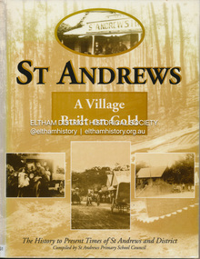
Book, St Andrews Primary School Council, St Andrews: A Village Built on Gold : the history to present day of St Andrews and District compiled by St Andrews Primary School Council, 2008
This history of the Victorian town of St. Andrews (formerly Queenstown) and its surroundings was written to celebrate the 140th anniversary of St Andrews Primary School. Describes the displacement of the Aboriginal inhabitants of the area, European settlement and the Gold Rushes and the Caledonia diggings. Discusses establishment of the school, church and cemetery and various other notable events. The school in 1998 and speculations on the future by primary school pupils. Contents: Introduction The First People Mining- What a rush! The School The Church Queenstown Cemetery The Hotels The Police Paddocks The Families Queenstown in the early twentieth century The Queenstown Bush Fire Brigade The 1st Queenstown Scout troop Queenstown, the 1940s and 1950s The Characters Odds and Sods St Andrews - The Present Times The Future St Andres Primary School in 1998This book is significant in that it documents the history of the St Andrews community from the indigenous presence through its foundation during the Victorian Gold Rush through to local bushfires and predictions of the future by local primary schools students in 1998. It remains the only significant secondary source publication written specifically on this rural community.Reprint edition with index 158 p. : ill., ports ; indexEx Eltham College copy Bendigo bank donation label inside cover Title page with stampings for D.D. Davey Senior Library Rear page date due slip st andrews, queenstown -
Eltham District Historical Society Inc
Document - Folder, Marshall, Alan
75mm White (PVC) Lever Arch binder containing Newspaper clippings, A4 photocopies of letters, photographs, Certificate of title of Park Rd property, etc, copy of talk presented by Andrew Lemon (2024)alan marshall, author -
Glen Eira Historical Society
Document - Morey Family
Two items of official documents for the Morey family: 1.Photocopy of Mrs Jean Monk’s baptismal certificate, St. Peter’s Church Murrumbeena. 2.Photocopy of certificate of Title to 21 Margaret Street, Murrumbeena. Has subsequent owners, other than the Morey family on documentrobertson stella jean, st. peter’s church, murrumbeena, caulfield, morey elizabeth ann, blair john arthur clerke, certificates, dutton edmund, dutton phyllis, atkinson bernard allan, buhler stella martha, holywood grove, newell frank jamesbornstein zelman, b.m. terry and staff pty ltd, zygier ted, zygier lea lucia, edinburgh avenue, beresford street -
Glen Eira Historical Society
Letter - St. James Parade, 11, Elsternwick
Five documents all relating to the estate of Lillian Jean Adami of 11 St James Street, Elsternwick A request for a sworn valuation on the auction price for the property and the contents from office of Public Trustee. A carbon copy of sworn valuation of the property and contents by Wv Scott FCIV. Includes an inventory and valuation of furniture and effects on and about the property, working notes on the valuation of the building and a copy of the Certificate title for Lot 16 subdivision 9341 on the western side of St. James Parade, Elsternwick Vol 5268. Folio 496 includes site plan and encumbrances referral.simmons s.p., plans, point nepean road, adami lillian jean, house, elsternwick, scott wv, st. james parade, prahan, estate agents, county of bourke -
Glen Eira Historical Society
Document - Orrong Estate
... documents Receipts Real estate agents Financial documents Lawyers ...Photocopy of the contract and conditions of sale of Orrong Estate to Ernest Melbourne Boyle, dated 12/01/1916. Includes a hand drawn plan of the area. Photocopied receipt for payment by Ernest Melbourne Boyle, dated 13/01/1916.orrong estate, orrong road, inkerman road, caulfield, labassa grove, pearson grove, sydney arnold best and co, yeo crosthwaite and co, east st kilda sand proprietary limited, east saint kilda sand proprietary limited, seton williams and heathfield, estate agents, legal documents, receipts, real estate agents, financial documents, lawyers, subdivision, land titles, auctions, auctioneers, buildings by condition, land sales, land values, boyle ernest melbourne -
Glen Eira Historical Society
Document - Hopetoun Street, 10, Elsternwick
Three items relating to valuations for this property: 1/One page typed letter from Weigall and Crowther Solicitors to S P Simmonds Estate Agency on behalf of Flora Lee, dated 03/10/1962, requesting valuation of 10 Hopetoun Street, Elsternwick re the Estate of G R Lee. 2/Four page typed valuation of 10 Hopetoun Street, Elsternwick, by Edward J K Callaghan, dated 10/10/1962. The valuation includes property measurements, title particulars, zoning, detailed information about the facilities in the surrounding area and also expansive details about the house on the property and other improvements. 3/Copy of a two page typed letter, from valuator WV Scott to George Lee, dated 22/12/1971, to Mr George Lee providing another later valuation of 10 Hopetoun Street, Elsternwick re the Estate late Flora Lee. Accompanying is a one page handwritten, undated and unattributed document of working notes.lee flora, lee george ralph, hopetoun street, elsternwick, weatherboard house, garages, korong road, king street, glenhuntly road, morton street, orong road, orrong road, kooyong road, lee george, callaghan edward j k, s p simmonds real estate agents auctioneer, scott w v, timber houses, murray street -
Glen Eira Historical Society
Plan - Centre Road, 734, Bentleigh East
A one page typed letter, dated 30/09/1970 addressed to S P Simmonds Estate Agency from William Lasica and Co Solicitors requesting a valuation of the property at 734 Centre Road, Bentleigh East. The file also includes four pages of handwritten, undated and unattributed working notes with property description, calculations and a rough plan (96mm x 94mm) of the ground floor of the building for the valuation. Also included in the file is a two page duplicate copy of a typed letter, dated 08/10/1970 from W V Scott to William and Lasica Co Solicitors containing the valuation of the relevant property and rental details. The file also includes a one page photocopy of a handwritten document dated 15/11/1967. It gives details of a previous mortgage. The file also includes a photocopy, dated 26/09/1970, of the Certificate of Title of Lot 6 of Subdivision No 60044 Parish of Moorabbin. It includes a plan of the property (139mm x 123mm).klauss anna sara, klauss edward, green william james, green margaret estelle, green william thomas, myers thomas lee, lombard joseph patrick, graham george kinnell, tobin thomas norman, mcintosh edward joseph, bentleigh east, east bentleigh, centre road, bentleigh station, omeo court, east boundary road, s p l constructions pty ltd, r k c nominees pty ltd, maryland street caulfield investors, flats, land values, land titles, rents, renting, \ -
Glen Eira Historical Society
Plan - Carinya Road, 13, Bentleigh East
A typed letter dated 20/03/1974 from R T Breen and Co Solicitors to S P Simmonds and Co Real Estate Agents requesting a valuation of the property at 13 Carinya Court South Oakleigh (sic). It includes handwritten notes. The file also includes a copy of a typed letter dated 09/04/1974 to R T Breen containing the valuation of the property at 13 Carinya Court South Oakleigh (sic) by W V Scott. Also included is a handwritten, unattributed document of calculations and measurements for property at Carinya Court, South Oakleigh (sic). The file also includes a photocopy dated 18/03/1974 of the certificate of title for 13 Carinya Court, South Oakleigh (sic). This includes a hand drawn plan (70mm x 65mm) of the property.centre road, warrigal road, mackie road, coatesville state school, architectural features, slorach john henry, slorach christine margaret, wolai avenue, carinya road, carinya court, bentleigh east, oakleigh south -
 Eltham District Historical Society Inc
Document, Nillumbik Shire Council, Nillumbik Shire Heritage Study Appendix 1, Graeme Butler & Associates, 2001, 2001
Provide the foundation for future planning assessments in the shire86 A4 pages (double sided) pages (photocopied) no binding or covers. Title page and pages 1, 74,75 and 76 missingnillumbik shire heritage study, graeme butler