Showing 289 items matching "kiewa history"
-
 Kiewa Valley Historical Society
5 small black and white photos of Clover Dam and Power Station, c1948
The construction of Clover Power Station was commenced in October 1942 and the power station building was completed in May, 1943. The first machine was placed in service August, 1944 and the second machine in May, 1945. The water discharges directly into Clover Dam and re-used in West Kiewa Station. Clover Dam - stripping of foundation area commenced in January 1948 but the final concrete pour was not until 14th August, 1954.Pictorial history of the early construction undertaken in the building of the Kiewa Hydro Electric Scheme. Clover power station (No. 3 Development) was the first power station to be built .5 small black and white photographsPhoto No. 1 - handwritten in ink on back ' No. 3 Power Station Clover Flat Nov. 1948 Photo No. 2 - handwritten in ink on back 'No. 3 Power Station Clover Flat Nov. 1948 Photo No. 3- handwritten in ink 'Clover Flat looking towards work area of Clover Dam. Taken near #3 PS. Nov. 1948 Photo No 4 - Handwritten in ink 'Preparation for wall of Clover Dam Dec. 1948 Photo No.5 - handwritten in ink 'Preparation for wall o f Clover Dam Dec. 1948. Photo Nos. 1,2 3, on the back have circular stamp with 'Print by Willson White Albury'. In pencil is the number '78'. Photo Nos. 4, 5, have written on the back in pencil, number '14'. construction, clover power station, clover dam, -
 Kiewa Valley Historical Society
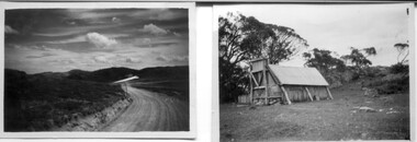
18 small black and white photographs of the Bogong High Plains, 1948
... of his time in the Kiewa area. Pictorial history of personal ...These photos of the Bogong High Plains were all taken by Ronald George Thorn who was a cadet engineer with the State Electricity Commission. He worked on the Kiewa scheme from 1948 to 1950 doing overhead line construction and maintenance plus electrical design and drawing work. They are from his personal collection and a record of his time in the Kiewa area.Pictorial history of personal involvement in the the early days of the Kiewa Scheme.18 small black and white photographs all taken on the Bogong High Plains.Photo 1 Wallace's Hut. Photo 2 Ruined Castle - Looking towards Pretty Valley December 1948. Photo 3 Ruined Castle - Looking towards Pretty Valley December 1948. Photo 4 Ruined Castle - Looking Down Valley December 1948. Photo 5 - Mt. McKay from Ruined Castle October 1948. Photo 6 View from Rocky Valley Camp October 1948. Photo 7 Mt. Feather Top from Ruined Castle October 1948. Photo 8 View from Ruined Castle looking downwards towards Beauty October 1948. Photo 9 Rocky River from gauging station October 1948. Photo 10 Rocky Valley River from main road October 1948. Photo 11 View along little Arthur Fire Track October 1948. Photo 12 View along main road. Looking towards Beauty Valley October 1948. Photo 13 View from Little Arthur Fire Track October 1948. Photo 14 Frying Pan Spur from Rocky Valley Road October 1948. Photo 15 Mt. Bogong from Big Hill Fire Track October 1948. Photo 16 View from Big Hill Fire Track October 1948. Photo 17 Mt. Feathertop from Ruined Castle October 1948. Photo 18 Mt. Fainter from Ruined Castle October 1948. (All of the above is hand written on the back of photos in ink). bogong high plains; r g thorn; secv; kiewa hydro electric scheme; pictorial history -
 Kiewa Valley Historical Society
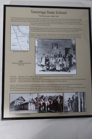
Posters - "Tawonga Remembers" x 5, 2016
The town of Tawonga is in the Kiewa Valley surrounded by farmland. It is adjacent to Mt Beauty (built from 1946), an SECV town built for workers on the SECV's Kiewa Hydro Electric Scheme, which was being constructed from 1911-1961. Tawonga consists of essential amenities including a store, school, post office, butter factory, sporting facilities, hall and hotel. Activities involved sport, social get togethers eg. dances, fund raising, CWA etc.The posters are a collection of historical photos, documentation and information re the history of the town of Tawonga, which is the centre of a farming community in the Kiewa Valley.Posters framed with thin black plastic strip, covered by glass. Each one has a title re "Tawonga Remembers" and includes print and photos in black and white. These have a beige background. 1. Tawonga 1907; 2. Tawonga 1962; 3. Tawonga State School- 1880-1929; 4. Tawonga Primary School -1960; 5. The Beginning of Change: 1930-1970tawonga, photos of early tawonga, kiewa valley, tawonga remembers, tawonga school -
 Kiewa Valley Historical Society
Photographs – Kiewa Cres Mt Beauty. Circa 1993. Set of 12 colour photographs, circa 1993
Established in 1946, during the construction of the Kiewa Hydro Electric Scheme, the township of Mt Beauty was developed by the State Electricity Commission of Victoria to provide additional accommodation for the thousands of workers during the construction of the country’s second largest hydro-electricity scheme. Although these towns were built as temporary accommodation for the workers and their families, many stayed after the scheme finished. Combined with the influx of European migrants, with their rich cultural backgrounds, all played a major part in shaping the future character of the Mount Beauty, the Kiewa Valley and Falls Creek. The Bright Council, now the Alpine Shire took over the control of the township in 1960. This relatively young town of Mount Beauty, along with the surrounding townships of Falls Creek, Bogong, Tawonga South and Tawonga, are all part of a prospering tourist area with excellent services, accommodation, food and a wide range of recreational activities available for all ages. According to Shire records, the population of Mt Beauty has grown from 1,500 in 1981 to 1,800 in 2016 with a projected increase to 2,000 in 2013The photographs taken around 1993 show a prosperous commercial centre catering for both locals and the needs of visitors. It provides a pictorial history of the changes which have occurred in the retail/commercial district of Mt Beauty over the years. It also demonstrates the attention paid by Alpine Shire towards providing accessible recreational green space around the town centre.Set of 12 colour photographs Kiewa Cres Mt Beauty. Circa 1993 showing retail services and streetscape of the time. No markingskiewa crescent mt beauty; shopping centre; -
 Kiewa Valley Historical Society
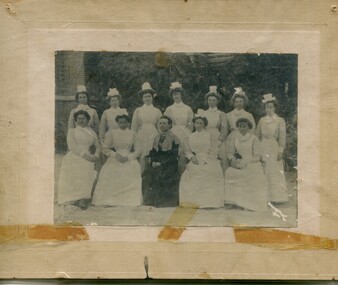
Photographs – Group of 3 old sepia photographs, 2 of women in period costume and 1 of group of nurses from Sunbury sanatorium
Europeans arrived in the Kiewa Valley in the 1830s and 40s. Following the drought of 1838-44 seeking out the rich pastures in the fertile Kiewa Valley. . The next major increase in population was as a result of the Kiewa Hydro Scheme. The beginning of construction of the Kiewa Hydro-electric scheme in the late 1940s introduced changes and led to the enlargement and improvement of local roads and the townships of Mount Beauty and Bogong Village were constructed by the SECV from the 1930’s to the 1950’s to house workers on the Kiewa Hydro Electric Scheme. At its peak the Kiewa Scheme employed around 4000 people from all walks of life and as many cultures.The influx of European migrants to work on the Hydro Scheme along with their rich cultural backgrounds, all played a major part in establishing the history of the area and in shaping the future character of the Mount Beauty, the Kiewa Valley and Falls Creek areas. Photographs may depict descendants, family or friends of early settlers or workers in the Kiewa Valley region.1. Sepia photograph, mounted on heavy buff card with yellowing marks from sticking tape across the bottom of the photograph. Photograph is of a group of nurses taken at the Sunbury Sanitorium 2. Sepia photograph mounted on heavy buff card with yellowing marks from sticking tape at top and bottom of photo. Mark from drawing pin in centre top of photo. Photograph is of a middle aged woman posing dressed in period costume 3. Sepia photograph mounted on heavy buff card with yellowing marks from sticking tape at top and bottom of photo. Mark from drawing pin in centre top of photo. Photograph is of an older woman posing dressed in period costume sepia photos; nurses; kiewa valley; sunbury sanitorium; period costume -
 Kiewa Valley Historical Society
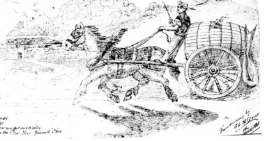
Postcard – Black and white illustration of horse and cart with driver, Circa 1881
Postcard production blossomed in the late 1800s and early 1900s. Postcards were popular because they were a quick and easy way for individuals to communicate with each other and became an efficient method of sharing information and photographs.Postcards provided a glimpse into the lifestyles of the sender which sometimes included a photograph of family or a hand drawn scene as in the accompanying example. As such, they formed part of family history.Black and white printed postcard of a hand drawn single horse cart with driver. Cart is carrying a large wooden barrel with hose attached. Brick homestead building in background. Unwritten on the rear. Handwritten inscription on bottom left of page - How we got our water in the pre Yan Yeanite era Handwritten inscription on bottom right of page – From drawing by G. G. McCrae Christmas 1881 postcard; horse and cart; -
 Kiewa Valley Historical Society
Papers - Edmondson's Hut, The letter is dated 8th October 1974
Edmondson's Hut is a cattleman's hut on the Bogong High Plains. Jim Edmondson obtained Run 33 (near Mt Nelse) in the early 1930s. He pre cut the timber at his property in Tawonga and along with iron for the walls, chimney and roof took it up to the Bogong High Plains on pack horse. The hut's wall and ceiling were lined and the hut had a 'fairly good floor and bunks'. In 1971 the hut was donated to the Education Department and was approved for transfer by the Lands Department in 1974. Bogong Outdoor School camp has been using the hut for students to camp in as well as National Fitness parties when walking in the area. The upper Kiewa Valley was settled from the mid 1860s and from its earliest days cattle were taken on to the Bogong High Plains to graze during summer. Jim Edmondson took his cattle from the Kiewa Valley to Mt Fainter and later to Run 33, near Mt Nelse. His hut is significant in the history of Cattlemen's huts on the Bogong High Plains.Four A4 typed sheets on white paper - 1. Acknowledgement of transfer of Edmondson's Hut. 2. History of Visitors (to the hut) Prior to 1971. 3. Two poems. 4. One poem 1. Emblem of Education Dept. Centre top of page. Addressed to James Edmondson, Tawonga, Victoria. 2. Page headed History and Visitors prior 1971. 3. My Old black Poley Cow (and) Roper's Track. 4. So Long, Mates!education department. edmondson's hut. bogong high plains. cattlemen. poetry. cattleman hut. bush walking. -
 Kiewa Valley Historical Society
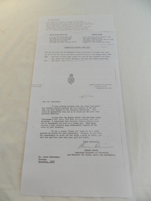
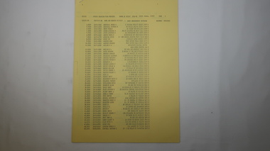
Book - Kiewa Voters' Roll, Shire of Bright - Voters' Roll 1979 - Kiewa Riding, 1979
Electoral rolls list people who are registered and eligible to vote at federal, state, territory & local government elections and referenda. Prior to 1990 the rolls list voters in alphabetical order by surnames & first names within each Sub division of an electoral division of each State or Territory. The roll is useful & interesting for family historians and the study of demographics. Alex McCullough lived in the Shire of Bright and was on its Council. Electoral roles help to locate the residential address of a person in a particular year or over a period of years. They can be used as a substitute for census records for family historians and the history of a particular place in this case the Kiewa Valley - Tawonga and Tawonga South.Approx. 60 pages of firm yellow paper with black typed print on one side only in 'landscape' format. Held by three staples. Each page has column - numbered 1 to 943; Surnames in alphabetical order; Given names; Occupation; includes L (=land). Address followed by Lot number and parish. Includes Tawonga and Tawonga SouthOn the cover on the right hand side handwritten and difficult to read - "Jack? / Indi / Benambra / Nth Eastern / Division? of Dawson / 123 Victoria Rd. / Melbourne 3000"shire of bright; kiewa riding; voters roll; alex mccullough; tawonga; tawonga south -
 Kiewa Valley Historical Society
Papers - Kiewa Riding Voters' Roll, Shire of Bright - Voters'Rolls 1985 (May and June) - Kiewa Riding, 4th July 1985
Electoral rolls list people who are registered & eligible to vote at federal, state, territory & local government elections & referenda. Prior to 1990 the rolls list voters in alphabetical order by surname & first names within each subdivision of an electoral division of each state or territory. The roll is useful and interesting for family historians & the study of demographics. Alex McCullough lived in Mt Beauty and was a councillor for the Shire of Bright.Electoral Rolls help to locate the residential address of a person in a particular year or over a period of years. They can be used as a substitute for census records for family historians and the history of a particular place - in this case Tawonga, Tawonga South, Falls CreekMay 1985 is 7 pages; June 1985 is 9 pages of firm yellow paper with black typed print on one side only. Held by one staple at the top left hand corner. The May 1985 - Each page has columns with 100 people listed up to 628 on page 7. Surnames are in alphabetical order followed by given names and then address. June 1985 Voters Roll (Non resident) is created from Property & lists Voters No. (up to 406) Property No. Name (alphabetical) & address and are non resident voters.shire of bright; voters' rolls; kiewa riding; tawonga; tawonga south; alex mccullough; falls creek -
 Kiewa Valley Historical Society
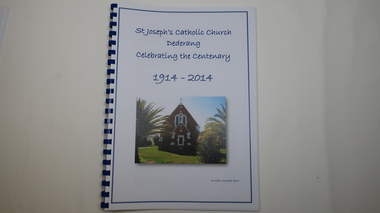
Book - Catholic Church Dederang, St Joseph's Catholic Church Dederang Celebrating the Centenary 1914 - 2014, 16th November 2014
Initially in the 1880s, services (known as stations) were held at Creamer's home in Dederang - generally x3 per year.In 1883 a small church was built where the present church now stands.This weatherboard church, St Joseph's, was replaced by a brick one in 1914 and opened on 8th Nov. 1914. The book has 9 chapters, the last one being 'Photo Gallery'. It covers the religious men, local families, newspaper snippets and records.Religion was an important part of life to people throughout the 20th century especially in a rural community as it gave people an opportunity to be part of the community and to socialize. This book gives a history of religion, of maintaining a church, of a rural community and of the Catholic religion.58 pages of printed history followed by 10 pages of colored photos in a spiral book with a blue spiral spine and a clear plastic cover. The front page includes the title in blue print with a colored photo of the church below the title.st joseph's catholic church dederang; kiewa valley; dederang families; catholic clergy; religion -
 Kiewa Valley Historical Society
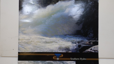
Booklet - Southern Hydro, Southern Hydro
Southern Hydro Ltd. was established in the late 1990s as a result of the disaggregation of the former State Electricity Commission of Victoria. It operates 10 power stations mainly in the north-east of VictoriaSouthern Hydro continued to encourage tourism as did the former State Electricity Commission of Victoria. This brochure is very similar to one previously published by the SECV "Victoria's Hydro Power" except only including those that it operates. Within the KHES the power stations were McKay Creek, Clover and West Kiewa. The change of ownership of hydro power from a government body to private enterprise in the late 1990s is of significant interest to the historian and consumer.Colored photo water spraying onto rocks with black strip across the bottom and logo (4 gold lines forming an "S", a blue triangle with grey cylinder beneath) of Southern Hydro within the strip. Back cover has a similar photo with 4 small photos of men inserted in the black column. This 23 page book gives a history of Southern Hydro and its 10 hydro-electric power stations that it operates. The book lists these and gives a description of each.Top right hand corner of page 5 has a piece of tape stuck over the print with "Page 11 to photo copy & enlarge" secv; khes; mckay creek power station; clover power station; west kiewa power station; mount beauty; rocky valley dam; -
 Kiewa Valley Historical Society
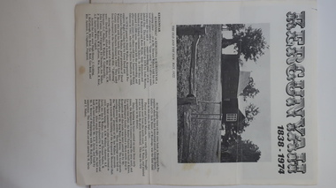
Leaflet - Kergunyah, Kergunyah 1838 - 1974, 1974
... Brigade. Kergunyah is in the Kiewa Valley. Its history ...Kergunyah is a small town in the Kiewa Valley in north east Victoria. It is 10km south of Kiewa (town) and 23 km north of Dederang (town). it is farming country commencing in 1838, developing into a small community in 1974 with a School, Church, Post Office, Football Club, Young Farmer Club C.W.A. Netball Club, Card Club and Fire Brigade.Kergunyah is in the Kiewa Valley. Its history is important in the valley as it developed from a large pastoral run in 1838 into a small community supporting the local farming industry with essential organisations eg. school, fire brigade and social organisations eg. sporting teams, C.W.A.. Its history is significant as this leaflet has details of the organisations up to 1974 and this detail can be compared to organisations at Kergunyah today and can be compared to the history of other small rural communities. White stiff paper, folded to A4 size, with black and white photos on each of the 4 pages. Each page has detailed information under headings of community buildings and clubs in the small town. kergunyah; kiewa valley; small community; rural town; -
 Kiewa Valley Historical Society
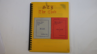
Folder - Mount Beauty Workmen's Club
The Mount Beauty Workmen's Club was established in 1946. Formerly known as the Kiewa Hydro Workmen's Club.Social history of Mount Beauty during the construction of the Hydro Scheme and its aftermath.Plastic spiral bound A4 folder with numerous plastic sleeves./ The folder contains club rules, some auditor's reports and financial statements and misc correspondence - mostly from 1990s./ Inside there are two rule booklets one red and one grey.On the top front cover of the red rules booklet is written 'Peart. A.L'.workmen's club, community club, west peak hotel, mt beauty, secv, kiewa hydro electric scheme -
 Kiewa Valley Historical Society
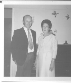
Photograph - Wedding Photographs x 2 - McKendrick, 11th January, 1958
Photographs of Ian and Margaret Rose McKendrick (nee Vyner) on their wedding day. Margaret was the daughter of Reta and Harry Vyner who were early residents of the Kiewa area during the construction of the Hydro Electric Scheme. Margaret and Ian were married at St. Mathews Anglican Church, Albury on 11th January 1958. The cream dress that Margaret wore was her Mother's dress, Reta Vyner. Note: Wedding Dress is stored in Box 66. Wedding Photo is in KVHS 0970(B) This wedding dress was part of a display in the Information Centre and is part of the social history of Mt. Beauty and Bogong Village during the construction period of the Kiewa Hydro Electric Scheme. It is typical of the apparel worn in the 1950's. Two photographs, one black and white and one sepia tone No inscriptions or markingswedding dress, clothing, mt. beauty, social history, mckendrick -
 Kiewa Valley Historical Society
Maps - Bogong x2, Tawonga, Omeo, Dargo, Victoria and others, 1. Bogong Alpine Area; 2. Bogong 8324; 3. Tawonga Topographical; 4. Omeo 8433; 5. Dargo 8323; 6. Victoria State
1. Bogong Alpine Area (outdoor Leisure Map. survey & Mapping Victoria, Government of Victoria, Edition 2, reprinted 1991 with an image of Mt. Feathertop on the front. Information for tourist in the Alpine National Park: Bogong Area. Including: recreational activities, history, weather and vegetation and a list of walks together with locality maps and photographs. The front cover has an image of Mt Feathertop against a blue sky with yellow writing 'Bogong Alpine Area', there is a yellow triangular block on the right hand top corner with black writing 'Outdoor Leisure Map. On the bottom edge is a block of yellow with black writing 'Survey & Mapping Victoria' and a light green map of Victoria with 'VICMSP' printed in white. 2. 8324 Bogong Victoria, Edition 1, Commonwealth of Australia 1981. A topographical Map: 1:100,000 scale (1 cm to 1 KM). Map has a red cover with white writing together with a white block and black writing and a map insert. 3. Tawonga Topographical Map - Forests Commission Victoria, / revised 5/9/77, DEG No. 68-G/399. A Tawonga 803 folded map in a beige colour with the back blank. 4. Omeo 8433 Victoria, Edition 1, Department of Natural Resources. The map has a red and white cover with black writing and a simple map of Australia at the bottom. 5. 8323 Dargo, Edition 1, Commonwealth of Australia. A red and white cover with a map insert. 6. Victoria State Map, Hema Maps, 2002. Hema Maps, State Map, colourful cover with a map of Australia and four tourism photographs. Scale 1: 850,000 An inscription handwritten in blue pen "Trappers Gap to Mitta Mitta 1" to 1 mile". There are some pen markings and notations of tracks.maps, bogong, omeo, tawonga, dargo, victoria, bogong alpine area -
 Kiewa Valley Historical Society
Papers - Memoir
Mary was born on 6th May 1939 and describe dairy farming in the Kiewa Valley throughout the years to c2020A handwritten family history of dairying in the Kiewa Valley consisting of 8 pages written with blue biro. A memoir by Mary Cardwell nee Creamer 'My early days of dairying in Kiewa Valley.'All pages are torn at the top.mary cardwell, dairy farming, kiewa valley, women -
 Kiewa Valley Historical Society
Calendar 2008
Brief history of the SECV construction town of Bogong which became a tourist town."Memories of Bogong Calendar 2008" Photographs of the physical environment. Front cover has a photograph of a person standing in a river. A short history of 'Bogong 1957-1963' and 'Come visit Bogong Village' a 'celebration of Bogong Village's environment'. 12pp with a hole (to hang up) in the centre bottombogong, calendar, tourism, bogong village, secv, kiewa hydro electric scheme -
 Kiewa Valley Historical Society
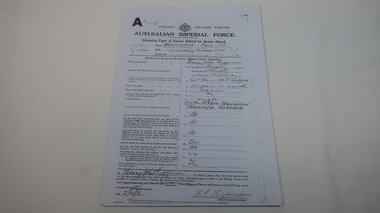
AIF Service Record of Henry John Higginson
The Higginson family farmed in the Kiewa Valley17 pages of photocopied pages from Henry John Higginson's enlistment and service history with the Australian Imperial Force (WW1)world war 1, war service, higginson, kiewa valley -
 Kiewa Valley Historical Society
Papers - Observation Walk on the Bogong High Plains. x5
Students study the Bogong High Plains noting geology, history, vegetation and evolution / changes.Environmental studies includes the effect of people, horses, skiing, infrastructure etc.Typed and hand written notes on the Bogong High Plains for students observing the vegetation. It includes geology and early history.bogong high plains, grazing, vegetation -
 Kiewa Valley Historical Society
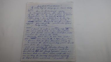
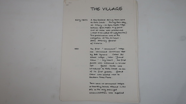
Papers - Falls Creek History, The Village
Timeline of Falls Creek during the 1950sFalls Creek is a snow resort on the Bogong High Plains, Victoria. The 1950s saw the village develop from its beginning to a popular ski resort.10 pages stapled top left corner. Includes a timeline of Falls Creek from early 1950s to the late 1950s. Titled 'The Village' and handwritten on one side only.falls creek, skiing, tourism, snow resort -
 Kiewa Valley Historical Society
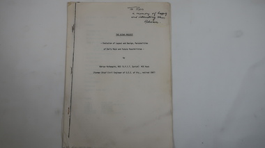
Memoir - Adrian Rufenacht, The Kiewa Project
Adrian Rufenacht, BCE (S.F.I.T. Zurich) MIE Aust. former Chief Civil Engineer of the State Electricity Commission of Victoria, retired 1967. Insight into the Kiewa Hydro Electric Scheme.First hand knowledge of the history of the Kewa Hydro Electric Scheme.40 pages stapled with 4 staples. The Kiewa Hydro Electric Scheme by Adrian Rufenacht, former civil engineer of SECV. Includes maps.On the front page - handwritten: 'To Ron / in memory of happy / and interesting times. / Adrianadrian rufenacht, khes, kiewa project, construction, secv -
 Kiewa Valley Historical Society
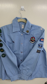
Uniform - Girl Guides Shirt
1st Tawonga Girl Guides during the 1970s. (Refer to filing cabinet in the Back Room of the Auditorium for history).1st Tawonga Girl Guides group in the Kiewa Valley. Popular movement for girls and well supported in the Kiewa Valley. Joy O'Connor nee Riordon lives in the Kiewa Valley.Blue shirt with collar and long sleeves "Girl Guide" steel gold clover-shaped badge on collar. Left sleeve 3 cloth badges sewn on one is "Be Prepared/Girl Guides and on left shoulder cloth badge "1st Tawonga / Barree Region. Left front - one large cloth badge. Right sleeve - 5 cloth badges sewn on - all "Girl / Guides". Right front - one steel badge of gold clover on blue background. "Joy Riordan" written on taggirl guides, tawonga, joy riordon, barree region -
 Kiewa Valley Historical Society
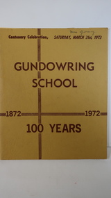
Book - Gundowring x2, Gundowring School 1872 - 1972 100 Years
A school was built in 1871, a shingle roofed wooden building built by the local residents. It was replaced in 1873 with the old school becoming the teacher's residence. The continues with a timeline, a pupil's insight into life at the school, a list of teachers and families. An interesting history of the area and education of the time. Gundowring is a farming town in the Kiewa Valley. The book gives an insight into the education and lifestyle of the time.Mustard cardboard cover with brownish print. Across the top "Centenary Celebration, Saturday, March 31st, 1973". It has 18 pages, some colored, printed on both sides and held together by 2 staples. It includes sketches.Glued inside the front cover "Mr & Mrs Roper & family" - Invitation. Also a newspaper cutting titled "Gundowring"gundowring, education, kiewa valley, school centenary -
 Kiewa Valley Historical Society
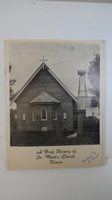
Booklet - St Mark's Church Kiewa x2, A Brief History of St Mark's Church Kiewa written by E. Temple
The Anglican Church at Kiewa. The first stone was laid on the 29th Oct. 1924. In 1879, the Yackandandah rector commenced services on Sundays in private homes in the Kiewa Valley. In 1911 Anglicans met in the Kiewa Methodist Church to elect a committee to organise financial offers and so it eventually became a vestry.The town Kiewa is in the Kiewa Valley. The church served other communities in the Valley. The book records the local populations and their commitment to religion. Cream cardboard cover with a black and white photo of the church on the front cover. It has 4 pages printed on both sides held by 2 staples. Inside there are a few black and white photos. Dated 19741. "Written by E. Temple" handwritten on the front cover 2. "C. Roper" on the front cover and inside the front cover "Clare Roper" Also, "Esther Temple" 's signature on the cover page.st mark's church, kiewa, anglican church, esther teple, thomas mitchell -
 Kiewa Valley Historical Society
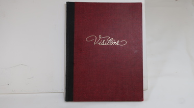
Book - KVHS Visitors 1969
KVHS set up a museum at the Tawonga Camping Ground in Dec. 1969. The building was sold so items were stored from Dec. 1981. In 1985 items were displayed in Tawonga South.KVHS's history as a museum includes visitors and their town of residence. It also shows that the KVHS had difficulty finding a home.Red book with gold 'Visitors' title and black binding. Inside front cover KVHS / Museum / Camping Reserve, Tawonga / Opened on 13th Dec. 1969 / by Councillor R.S.Hollonds. 12 pages used and goes to 1981kvhs, museum, tawonga, tawonga south -
 Kiewa Valley Historical Society
Book - Diary - G.P. Lyons SECV x4, 1. Catherine Moss; 2. Crossing the Rubicon; 3. Running the Line; 4. Twilight of the Gods
Geoff Lyons worked initially as a storeman for SECV on the Kiewa Hydro Electric Scheme and later possibly as a linesman on the transmission lines from Mt Beauty to Melbourne.A social history of working in the north east on a construction site. Geoff worked with European migrants in his youth and describes his life as a young man - an interesting comparison to life in the 2020s.4 Books with coloured (2 tones) cardboard cover with hard plastic attached. 1 and 2 books are bound by white plastic strips 3 and 4 are bound with white tape. 1. 1951-52 with 150 pages; 2. 1952-53 with 130 pages; 3. 1954-55 with 101 pages; 4. 1955-56 with 122 pages.All 4 books have "To Colin & Lyn Maxwell from Joy and Geoff Lyons" handwritten on the first page.geoff lyon, storeman, linesman, secv, khes -
 Kiewa Valley Historical Society
Papers - History of Mt Beauty Football Club 1974
Ian McKendrick was secretary of the Mt Beauty Football Club on 8th Aug. 1974. He compiled important papers re the club's history and stored them in an envelope for future reference and preservation with the idea of each secretary passing the envelope on to the next secretary.Mt Beauty football club was formed at a meeting on 19th Sept. 1974 attended by Bogong Tawonga Football club when the club changed its name. The Mt Beauty football club has since amalgamated with the Dederang football club. List of footballers in 1975 is helpful for researching local families living in the Kiewa Valley. An envelope titled 'Notice to Secretary' and 'List of Documents'. Enclosed 15 pages comprising of 1. Newspaper cuttings, 2.Typed pages with the title - 'Recreation Reserve pavilion - Mt Beauty', 3. Typed page title 'Mt Beauty Recreation Reserve Drainage', 4. Plan of Mt Beauty Recreation Reserve pavilion sketch 1975, 5. Handwrittten page title re P. O'Brien Years of Association 1950 - 1974 and names of teams on the back.. There is more than one copy of some pages. 1970smt beauty football club, ian mckendrick, bogong tawonga football club -
 Kiewa Valley Historical Society
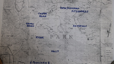
Map - Cattlemen from Kiewa Valley
Cattle grazing on the Bogong High Plains occurred on most summers since the 1840s. The families were farmers from the Kiewa Valley. The 2003 fires interrupted this tradition which was discontinued altogether in 2005 for environmental reasons. This tradition is still controversial.History of Cattle grazing on the Bogong High Plains and farming in the Kiewa Valley and the families that lived there.Photocopied topographical map of part of the Alpine National Park showing 11 families areas for cattle grazing. Dated 1991/92 up to 2003 fires.91/92 Until fires in 2003 Families names have been added in blue texta. They are: 'Kelly, Faithful, Weston Briggs, Ryder, Cooper, Blair, Roper, Maddison, Fitzgeralds, Hicks.'cattlemen of the kiewa valley, cattle grazing on the bogong high plains -
 Kiewa Valley Historical Society
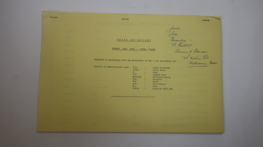
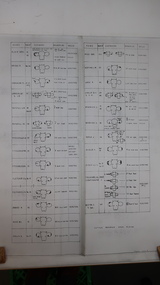
Chart - Cattlemen Families of the Kiewa Valley and their Brands, Cattle Grazing on the Bogong High Plains
Cattle were taken up to the Bogong High Plains by the Kiewa Valley farmers who had a lease there in their allocated area. The cattle roamed and were mustered in late summer. At this time they also sorted the cattle using the cattle's brands for identification.Types of breeds bred in the Kiewa Valley and the names of families who grazed cattle on the Bogong High Plains is of historical interest and also gives an insight into the history of cattle grazing.White paper, black print. Chart's headings: Name of Family (25 in alphabetical order), Run No., Earmark, Brand and Log and Breed. 29th Feb. 1972 cattle grazing, bogong high plains, kiewa valley families, cattle breeds, cattle brands -
 Kiewa Valley Historical Society
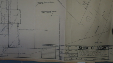
Plans - Mt Beauty Swimming Pool & Amenities Building, Mt Beauty Swimming Pool & Amenities Building by Shire of Bright
Mt Beauty's Swimming Pool was built by Alpine Shire and included a Squash Court. October 1986. Previously the community swam in the West and East Kiewa Rivers. The pool enabled all of the community to swim in a safe area and the opportunity to swim long distances.History of swimming for the Kiewa Valley community and its affect on the following - social, education, and tourism6 large pages of black print on yellowed paper. Dated October 1986 and includes plans for the Mt Beauty Swimming Pool and a Squash Court.On back of the 6th plan in red pen "Roger Sorry Delay / Getting Plans Back / Norm Boden"mt beauty, swimming pool, squash court, shire of bright