Showing 19773 items
matching coast
-
 Bayside Gallery - Bayside City Council Art & Heritage Collection
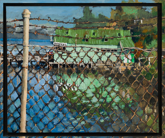
Painting - acrylic on canvas, Mike Green, Keefers, 1976
In the early 1900s, Melbourne builder Charles Keefer was hired by the Moorabbin Council to build the municipal baths at Beaumaris. In 1903, Keefer took over the Beaumaris Boat House and enlarged it to form Keefer's Boat Shed where day trippers and holiday makers could hire boats and venture out into the bay. Although rebuilt following the devastating storms in 1934, Keefer’s Boat Shed was completely destroyed by fire in 1984.Realismkeefer's, boatshed, bayside, coast, beaumaris, fence, water, bay, charles keefer, pier, mike green -
 Bayside Gallery - Bayside City Council Art & Heritage Collection
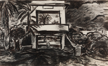
Work on paper - charcoal on paper, Craig Gough, The rotunda (from 'Sandringham series'), 1983
charcoal on papersandringham, craig gough, coast, boat, port phillip bay, sailing, half moon bay, palm tree, sandringham band rotunda, fountain, rotunda -
 Ballarat Heritage Services
Photograph - Digital photographs, L.J. Gervasoni, Middle Island, Warrnambool, 2012
Digital images of Middle Island Stingray Bay warrnamboolvictoria, river, mouth, coast, ocean, island, middle, middle island, warrnambool, merri, merri river -
 Lake Bolac & District Historical Society
Colour photograph, Fiery Creek, Lake Bolac, 1997-2010 drought
Lake Bolac's eastern lake-bed and beach during the 19987-2010 drought, looking south. The lake bank exposed in this photograph is an aboriginal midden about a likometer across excavated by Dr Peter Coutts in the 1970's. Radio carbon dates of charcoal from the base levels date the midden at 12,000 years old, making this one of two middens with this very early date, the other being on the coast near Warrnambool. lake bolac, aboriginal midden, dr peter coutts -
 Uniting Church Archives - Synod of Victoria
Photograph, November 1978
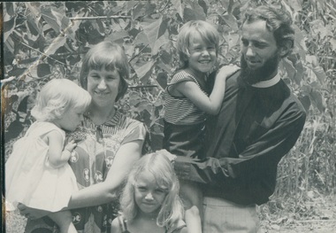
Ordained 1971, first Placement was at Horsham 1970-1971, then in 1972 moved to the NT and to Milingimbi 1972 to 1978; moved to Tas and the West Coast 1979-1983. Moved across to East Derwent 01.84 to 12.89, moved back to Victoria 01/90 and went to Northcote Thornbury was there until 03.96. In a Chaplaincy from 04.96 to 06/97, at Mill Park From 09/97 to 08/99, waiting for placement in 09/1999. B&W photo of Brad Harris standing outdoors with his wife and children.rev. e. bradley harris;, minister -
 Bendigo Historical Society Inc.
Document - STRAUCH COLLECTION: FEHMARN FAMILY INFORMATION
Fehmarn is an island in Germany on the Baltic coast. It was formerly part of Denmark. One of the Fehmarn residents that came to Bendigo was Jurgen La Frenz (1836-1915). He came to Australia in 1855 and after some time on other goldfields, he arrived in Bendigo in 1860. He initially sought his fortune by puddling before moving on to quartz mining. In 1872 he married Mary Parker and they resided at "Fehmarn" in Myrtle Street.Loose information & letters relating to the Fehmarn family and other German families.document, memo, german -
 Warrnambool and District Historical Society Inc.
Article, Newspaper S McDonald, 1940’s
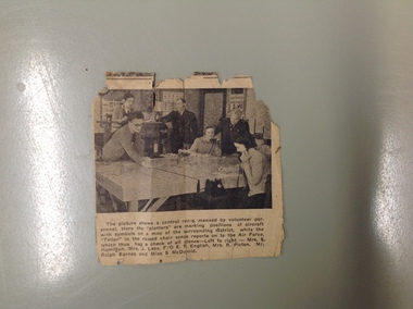
The Volunteers Air Observers was formed in 1941 with the aim of observing aircraft flying over Australia. There were over 24000 civilians volunteering their services and as the military threat to Australia subsided they took on roles as coast and weather watching. This photograph shows a group of local volunteers at their work. Mrs. S Hamilton, Mrs. J Lees, F/O E F English, Mrs. R Picton, Mr. Ralph Barnes and Miss S McDonaldA local item which relates to an organization which operated around Australia in the 1940’s. Small newspaper cutting with photograph with six people around a table. Text is underneath the photo. The back has an advertisement for Fletcher Jones clothingThe picture shows a control room manned by volunteer personnel. Here the plotters are marking positions of aircraft with symbols on a map of the surrounding district while the Teller in the raised chair sends reports on to the Air Force, which thus has a check of all planes left to right Mrs. S Hamilton, Mrs. J Lees, F/O E F English, Mrs. R Picton, Mr. Ralph Barnes and Miss S McDonald volunteer air observers corps,, volunteer air observers corps,, mrs. s hamilton,, mrs. j lees,, f/o e f english, mrs. r picton, mr. ralph barnes, miss s mcdonald warrnambool -
 Warrnambool and District Historical Society Inc.
Booklet, Tide Tables, For the year 1976
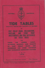
Yearly publication showing predicted heights in metres for Port Phillip Heads, Williamstown, Portland and Stony Point (Westernport) and tidal differences for other Ports.This booklet provides tide and port information for the coastline of Victoria for the year 1976. It also has information on other aspects of weather such as wind, cloud and sea descriptions. These booklets were a useful reference for fishermen and those involved in boating along the coast of Victoria. They are published in digital form today.Sold at Stan McPhee Sports store Liebig St Warrnambool Vic showing local tides. Red card wrap around cover. 92 cream coloured pages held with 2 staples. Black print. Ports and harbour seal on the frontBooksellers stamp: ink. blue Stan McPhee Sports, green Liebig St Vic. red ...2953. 6717/75. C.H. Rixon, Government Printer, Melbourne. 51st Edition. Recommended price $3.00. Tables for Sunrise, Sunset/moonrise, moonset and transits at Port Phillip Heads & differences for other Victorian and Tasmanian Lighthouse stations.tide table, warrnambool tide table 1976, southern victorian tides -
 Robin Boyd Foundation
Document - Manuscript, Robin Boyd, The Best Houses in the World, 1965
Robin Boyd was on the judging panel for the American Institute of Architects, in conjunction with Sunset magazine, "Best houses" in the West Coast USA in 1965. Interesting commententary is given about the 364 houses entered and the award-winning houses. Some conclusions about what is new in planning are drawn. Comparisons are made with the best Australian houses and landscape architecture of 1965. This manuscript of Boyd's weekly newspaper column in 'The Australian' was published with the same title on 31/07/1965.Original manuscript of an article published in The Australian, 16/10/1965.Two copies. One typewritten (c copy), pencil edits and additions. Second typewritten (p/copy). Both quarto, 7 pages.american institute of architects, california, sunset magazine, house design, 1965, landscape design., robin boyd, manuscript, ohm2022, ohm2022_16 -
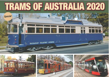 Ballarat Tramway Museum
Document - Calendar, Topmill Pty Ltd, "Trams of Australia 2020", 2019
Wall Calendar - heavy card covers, 12 gloss art pages inside, titled "Trams of Australia 2020" containing cull colour photographs of Sydney, Brisbane, Adelaide, Perth, Bendigo, Ballarat, Gold Coast, Newcastle. Has a punched hole along the top edge to enable wall use. Provides dates for holidays, school holidays and Pension payment days and phases of the moon. Produced by Topmill Pty Ltd and distributed by Gordon & Gotch Pty Ltd. Ballarat photos feature Cuthberts939, 12 and 43, the latter at Sturt and Lydiard St intersection. Photos by Norma Perry, Richard Youll, Ben Parle, Maurice Kelly, Bill Angrove. Bendigo Tramways and BTM.tramways, trams, ballarat, bendigo, brisbane, sydney, gold coast, perth, rockhampton, newcastle -
 Orbost & District Historical Society
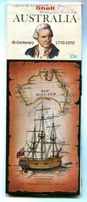
map, Shell Australia, 1970
This Shell road map was made as part of the 200 year celebration of Captain James Cook's voyage on the HM Endeavour and the first sighting of Australia at Point Hicks in 1770. The Bicentenary of James Cook in Australia was commemorated in Australia in 1970. The British explorer Lieutenant (later Captain) James Cook sailed and charted the East Coast of Australia in 1770, and claimed the eastern seaboard of the Continent for the British Crown. This was not considered the official bicentenary of Australia, but rather the mapping of the Eastern coastline. This item reflects the commemoration of a significant event in Australian history.A coloured foldout touring map of Australia with a picture of James Cook and the ship, Endeavour, on the front.map-australia bicentennial-cook-1970 -
 Federation University Historical Collection
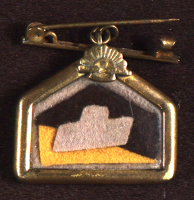
Badge, Chatham-Holmes Collection: Black and Yellow Army Patch/Badge
Unlike most Australian armoured formations that served only in Australia, the 4th had been organised for “tropical” service and its regiments were equipped with Matilda tanks. Matilda tanks were ideal for supporting the infantry’s operations in the Pacific. In June the brigade moved to Southport, on the Gold Coast, but two months later was transferred to Madang, New Guinea, where it replaced the 1st Tank Battalion. (https://www.awm.gov.au/collection/U54340, accessed 07 September 2018)Gold shaped badge with pin with the Colour Patch of the Second 4th Australian Armoured Regiment.armoured, tank, war, chatham-holmes collection, samuel spittle, world war two, sweetheart brooch, 2/4 armoured regiment, armoured regiment, jewellery -
![Three sea kayaks on display at the QMM commemorating historic journeys. Orange one was used by Earl de Bonville [Bloomfield] who circumnavigated Tasmania in 1979. Yellow one used by Paul Caffyn in his 1981/2 first circumnavigation of Australia in a sea kayak. White one belonged to Freya Hoffmeister who solo circumnavigated Australia in 2009.](/media/collectors/4f729f7e97f83e03086018d1/items/5fae1faf0557592050ca91e5/item-media/5fae20230557592050ca9478/item-fit-380x285.jpg) Queenscliffe Maritime Museum
Queenscliffe Maritime MuseumVehicle - Kayak and journal
Australia’s first modern sea kayak expedition: “The journey they said couldn’t be done” Members: Earle de Blonville & John Brewster First kayak expedition to circumnavigate Tasmania’s 1,600 km coastline Route: The 1798-99 route of Bass and Flinders in the ‘Norfolk’ Start and finish Georgetown: anticlockwise via the west coast and Hobart. Media covers the Tasmania expedition itself, plus the pre-Tasmania training voyages in Scotland and the Hebrides, plus resulting articles.Kayak used in 1979 circumnavigation of Tasmania by Earl Bloomfield, accompanied by journal of expedition and photographs Sea Kayak, Nordkapp designsea kayak, circumnavigation of tasmania, earl de bonville, earl bloomfield -
 Queenscliffe Maritime Museum
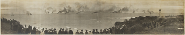
Photograph - One original photograph and one framed and mounted copy of the United States Atlantic Fleet entering Port Phillip Bay in 1908, United States Fleet entering Port Phillip
On 29 August 1908 Melbourne gaped in wonder as 16 white-hulled battleships of the United States Atlantic Fleet, carrying 14,000 naval personnel, steamed into Port Phillip Bay. The ‘Great White Fleet’ was circumnavigating the globe on a tour launched by President Theodore Roosevelt. The cruise was a display of naval power and practical exercise, testing the battle-readiness of the US Navy and demonstrating its ability to patrol and protect the west coast and American interests in the Pacific including Australia.An original unframed photograph of the United States Altantic Fleet entering Port Phillip Bay in 1908 and a copy framed and mounted under glass.Port Phillip Bay 1908; United States Atlantic Fleetthe great white fleet, us atlantic fleet, 1908, port phillip bay -
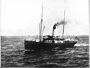 Port Fairy Historical Society Museum and Archives
Photograph, Lady Loch
Government steamer serving lighthouses along the coast and in Bass Straight Steamer, 146 nhp. Built 1886. Built In Melbourne. Tonnage 487g 337n. Built By Campbell, Sloss & M'Cnn Dimensions182.7 x 24.6 x 14.4 Demise Campbell, Sloss & McCann, Sth Melbourne. Lighthouse tender. Later: Victorian Government (Department of Public Works), reg. Melbourne. Later Moreton Tug & Lighter Co. 1962: Scuttled at Dunwich, Moreton Bay, Qld.Black and white photographship, boat, river, sea -
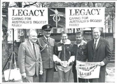 Melbourne Legacy
Photograph - Photo, RAAF Runners for Legacy 70th Anniversary, 1993
Photograph of a Legacy event in Melbourne City Square in 1993. President John Stevenson is presenting a runner with a Legacy plaque for his efforts. It was part of the RAAF 70th Anniversary "Legs for Legacy" run down the eastern coast of Australia with the money going to Legacy. Melbourne Legacy received a portion of the funds raised. The run took 21 days and covered 5,000 kms, by 31 RAAF personnel. The Legacy banner behind says Legacy Caring for Australia's Biggest Family.A record of an event organised by the RAAF for promoting Legacy.Black and white photo of a Legacy event in Melbourne City Square and 2 articles in The Answer.Handwritten in blue pen "B Pg 3 / 23"legacy promotion, answer, raaf, adf personnel -
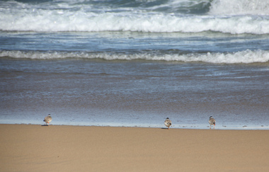 Ballarat Heritage Services
Digital photographs, L.J. Gervasoni, Hooded Plovers on the Killarney Beach shoreline, c2015
Photographs of endangered Hooded Plover birds on Killarney Beach, Victoria.killarney beach, killarney, beach, coast, ocean, hooded plovers, birds, seascape, waters edge, shoreline, waves, endangered -
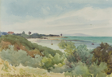 Bayside Gallery - Bayside City Council Art & Heritage Collection
Work on paper - watercolour, Charles Douglas Richardson, Brighton Beach, 1914
watercolourlandscape, beach, brighton, coast, water, boat, charles douglas richardson, cd richardson, c douglas richardson, bayside, mountain, bay -
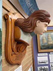 Phillip Island and District Historical Society Inc.
Sculpture - Figurehead, Late 19th Century
Saved from the ship Speke which ran aground on the coast of Phillip Island on the 22nd of February 1906. The figure head of the Speke was in the shape of woman, wearing a flowing white dress with blue cuffs and collar and carrying a large bunch of daffodils. It was originally nine feet four inches long. This sculpture went missing after the event and decades later the head only was re-discovered in Mr Thompson’s garage. It was then restored by Headmaster Kevin and the senior children of Cowes State school in 1940.The Speke was an all steel ship built in Wales in 1891. She was delivering wheat to Geelong and confused a bushfire in Cowes for navigation lights. Many local people salvaged goods from the resulting wreckage.Large wooden figure head, carved to resemble a woman. Painted aspects of hair, face, collar. Mounted on an undecorated wooden shield.phillip island, speke, kitty miller bay, figurehead, cowes state school -
 Glenelg Shire Council Cultural Collection
Poster - Poster - Portland Upwelling Festival, Oct-09
The Bonney Upwelling is the epic natural ocean occurrence that powers a 7 month ( November – May ) feeding frenzy of marine animals, supporting an incredibly rich ecological food web. The Upwelling is at its greatest off the coast of Portland and is the corner stone of our lucrative fishing and tourism industries. Presented by the Upwelling Festival Committee Inc. The Upwelling Festival is a free one day event that brings the community and visitors together to celebrate what is unique about our beautiful coastal environment in Portland Victoria.Two A3 sized posters promoting Portland's Upwelling Festival, Saturday October 31 2009. Shiny White paper. Printed over with pale grey. Blue outline of whale in blue sea; Dark/light blue and green ribbons of colour lead to lighthouse. Features of Festival printed in dark/light blue,green,grey. sponsors names and logos along bottom edge.upwelling, community, festival program, marine -
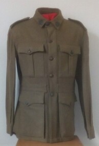 8th/13th Victorian Mounted Rifles Regimental Collection
Uniform - Motor regiment
Upon mechanisation in December 1941, 20th Light Horse (Victorian Mounted Rifles) was re-titled 20th Motor Regiment (Victorian Mounted Rifles). It was equipped with Bren Gun Carriers and deployed to airfield defence in Northern Territory. In 1943, the Regiment was deployed to Merauke, Dutch New Guinea, where it conducted patrols along the coast and up rivers using barges and canoes. Returning to Australia in April 1945, the Regiment was redesignated 20th Pioneer Battalion then disbanded several months later at the end of the war. Good quality reproduction.Khaki woollen tunic with colour patches of 20th Motor Regiment. Metal 'Australia' shoulder titles, metal Rising Sun collar badges and metal buttons.20th motor regiment, uniform -
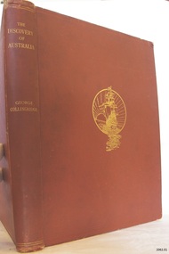 Flagstaff Hill Maritime Museum and Village
Book, The Discovery of Australia
The Osburne Group was was three people, headed by Warrnambool Lawyer Dan Madden, who in the 1980’s republished a few local historical books. Collingridge’s (1847-1929) book ‘The Discovery of Australia’ was a work which supported the ‘legend’ of a Portuguese voyage of exploration, which led to the loss of one of its ships in 1522, believed to be the Mahogany Ship, on the coast south of Tower Hill. Hence European charting of the east coast of Australia centuries before Captain Cook, which the British historians viewed almost as heresy. TheOsburne Group acquired copies of Collingridge from the publisher, and saw that they were made available as a historical record supporting the research of Ken McIntyre, who in 1981 published separately a book called ‘The Secret Discovery of Australia’. The first book by the Osburne Group was republished in facsimile. It was the ‘History of Warrnambool’, collated and printed by Richard Osburne in 1887 after he had sold his newspaper the Warrnambool Examiner to Fairfax, which took up the name of Warrnambool Standard. Hence the name Osburne. Other books reproduced in facsimile form include ‘By These We Flourish’ by C.E.Sayers, and ‘Warrnambool Past and Present by Edward Vidler.The Discovery of Australia Author: George Collongridge Publisher: Kayes Brothers Date 1895 Has a sticker on front loose end page stating " Presented to Flagstaff Hill by Osburne Group"flagstaff hill, warrnambool, shipwrecked-coast, flagstaff-hill, flagstaff-hill-maritime-museum, maritime-museum, shipwreck-coast, flagstaff-hill-maritime-village, the discovery of australia, book, george collingridge, osburne group -
 Warrnambool and District Historical Society Inc.
Booklet - Booklet Collection: City of Warrnambool Tourist Guides, Collett, Bain and Gaspar, Warrnambool
This is a collection of sixteen tourist guides dating from the mid 1970's to 2013. These contain listings of businesses, accommodation, eateries and events in Warrnambool and district. They also include maps of Warrnambool and surrounds, advertising and photographs of various attractions. While mainly covering Warrnambool a small number of the guides cover the South West Region. These directories have mainly been published by the Warrnambool City Council and are a selection of the types of information provided to visitors at the Tourist information centre during this time period.These tourist guides give snapshots of the City of Warrnambool for the years covered and will be useful for research.[.1] An 8 page paper booklet with black printing and a black & white photo of the pond at the Botanical Gardens on the front cover. [.2] two photocopied A4 black and white pages from the book "On the Trail" K Winser 1956 (Main Roads of Australia) [.3] A trifold colour brochure with a stylised map of the coast on the yellow and blue front cover. The inside has stylised colour drawings on Warrnambool attractions. The rear cover has coloured photographs of bush, Liebig Street and Fletcher Jones gardens [.4] A trifold black and white brochure with a black line drawing of a whale on the front cover. [.5] A trifold white card with mauve printing. The front cover has a line drawing of the former Timor Street post office and a map of businesses and landmarks in Timor Street. The reverse side contains a brief history of Warrnambool. [.6] A 98 page stapled booklet with a foreword by Vanda Savill. There are 4 pages of coloured photographs. The remainder are black and white photographs. The front cover is purple with white writing in the lower third. There is an outline of the coast and five colour photographs of district attractions. The inside middle page has a map of the Western wonderland region. The content covers towns in this area. Content relating to Warrnambool is in the last six pages. [.7] Twelve loose photocopied black and white pages. The front cover has the Warrnambool Premier Town 1988-1991 logo and a photo of a Southern Right Whale and calf. The bottom right hand corner has a Standard Warrnambool logo. [.8] 44 page booklet printed with blue ink. The staples have been removed. The glossy front cover has blue printing with a coloured photo of Flagstaff Hill Maritime Village pond. The centre pages has a fold out map of the City of Warrnambool. The rear cover has photos of The Twelve Apostles and Hopkins Falls. [.9] 4 loose photocopied pages with Warrnambool Library and Corangamite Regional Library Service Warrnambool City Library black ink stamps. The front page line drawing illustrations of Warrnambool attractions [.10] A single sheet of glossy white paper folded in half to make four pages. The front page has a Warrnambool premier town logo 1979-1982 and blue printing and a visitor survey. [.11] A conference pack of light card folded to make a pocket containing three brochures, a shipwreck coast tourist directory and a Australian Heritage Parks Association conference program dated 24 to 27 May 1992. The front cover of the pack has green writing over a stylised upward arrow. There is a City of Warrnambool logo in the top right hand corner and two film strips diagonally across the cover containing photographs of Warrnambool. The rear cover has a coloured Warrnambool Premier Town logo. [.12] A 63 page stapled booklet with coloured photographs of Warrnambool. The front cover has black writing on white background. There is a coloured photograph of Flagstaff Hill in the middle of the cover and a Warrnambool City and Visit Victoria logos on the lower edge. The middle pages has a coloured of the city of Warrnambool with an inset map of Allansford. [.13] A single large sheet of white paper folded in ten to make a brochure. The front cover has black printing. The rear cover has a purple ink stamp for the City of Warrnambool Tourist Information Centre. When folded out the reverse side has a green, grey and white map of the South West Region of Victoria. [.14] A 48 page colour booklet on glossy paper. The front cover has white writing on a blue background and includes photographs of the Twelve Apostles, the Promenade walk, Flagstaff Hill and a southern right whale's tail. The rear cover has photographs of The Twelve apostles, a passenger train from Melbourne passing the Lake Pertobe playground, and a rural scene. There is white writing and a white Warrnambool City logo on a blue background. The centre pages have a stylised green and blue map of the city of Warrnambool. [.15] A 48 page colour booklet on glossy paper. The front cover has white writing over colour photographs of two people at a lookout, Flagstaff Hill, three southern right whales and a child at the Lake Pertobe playground. The lower edge has blue upper case writing on a white background. The rear cover has a colour photograph of the Twelve Apostles. The lower white border on the rear covers has a a blue and green City of Warrnambool logo and blue writing. The centre pages have a stylised green and blue map of the city of Warrnambool. [.16] A 64 page colour booklet on glossy paper. The front cover has black writing on a black background and there is a photograph of a southern right whale's tail. The lower edge has the Warrnambool City and Visit Victoria Logos. The centre pages have maps of Warrnambool and surrounds. [.1] This week in Warrnambool Vol 2 No. 5 Thurs 1st Feb. For the time of your life [.2] Warrnambool Way [.3] Warrnambool The Holiday Host on the South West Coast with compliments City of Warrnambool and Warrnambool Chamber of Commerce [.4] MMI Insurance presents Whales Giants of the Deep Whale Watcher's Logbook Warrnambool [.5] Warrnambool History began in Timor Street [.6] Western Wonderland Tourist Association [.7] A Premier Arrow Tour of Warrnambool Victoria's Premier Town Australia's Southern Right Whale Nursery [.8] Warrnambool The Heart of Victoria's Great Southwest Visitor's Handbook [.9] What to see in Warrnambool Victoria's Premier City 1979-1982 [.10] Win a Free Holiday & $200 Cash in Victoria's Premier Town [.11] Advancing Warrnambool together! [.12] Great Ocean Road Warrnambool Official Visitor Guide [.13] Tourist guide to the South West Region Victoria All it needs is you [.14] Warrnambool visitor guide 2005 the great ocean road experience attractions accommodation entertainment dining [.15] Warrnambool Visitor Guide 2006 the great ocean road experience Attractions Accommodation Entertainment Dining [.16] Official Visitors' Guide Warrnambool Victoria Australia Discover the Great Ocean Road warrnambool, warrnambool tourist guides -
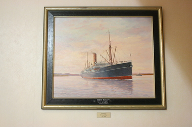 Geoffrey Kaye Museum of Anaesthetic History
Painting, Ib Odfeldt, S.S. Ulimaroa
Dr Bernie Dunn spotted a model of the merchant ship 'Ulimaroa' at Pollywoodside Museum after which he commissioned Ib Odfeldt, a Danish prize winning marine artist, to depict the vessel at sea.The painting was later gifted to ANZCA in 2006. John Traill, co-owner of Huddart Parker Ltd, named the ship in 1907 after his family home 'Ulimaroa' the building which was later purchased by the newly established ANZCA. The S S Ulimaroa was one of the popular ships in the Huddart Parker fleet that was in regular service between Australia and New Zealand from 1908 to 1934. This service was interrupted by WWI when it was commissioned by the NZ Government to carry troops. During the depression it was de-commissioned where it lay in Sydney Harbor until 1934 when it sailed under its own steam to Japan to be converted into scrap metal. Oil on board painting of the merchant ship S S Ulimaroa on the Derwent River, Hobart, with landscape in distance and small steam boat on of main ship. Set in a plain gold and black wooden frame.[on frame in white ink] HUDDART PARKER LTD. / 1908 1934 / S/S ULIMAROA [on reverse in black ink] THIS PAINTING WAS COMMISSIONED / BY DR BERNARD L. DUNN & WIFE JEAN. / FOR THE ANZ COLLEGE OF ANESTHETIST 2006 ("ULIMAROA" ST KILDA RD MELBOURNE ) / TITLE: ULIMAROA ON THE DERWENT RIVER, (TASMANIA) / ARTIST IB ODFELDT / MEDIUM: OIL ON BOARD 2006 / THE SMALL STEAMER IN THE BACKGROUND S/S WARRENTINA / 808 CYGNET COAST RD / PETCHEY'S BAY 7109 TAS. / RED STAMP dunn, bernard, ulimaroa, odfeldt, ib, parker, huddart, traill, john -
 Orbost & District Historical Society
book, Impact Printing, Clonmel, 1999
The paddle steamer Clonmel was one of the first steam-powered vessels on the Australian coast. However, its career was short, being wrecked on its third voyage on what is now known as Clonmel Island at the Port Albert entrance. All on board reached safety, but much of the cargo was lost.The wreck of the Clonmel was instrumental in the settlement of Gippsland and the establishment of the towns of Port Albert, Tarraville and Alberton. Although the wreck of the Clonmel was a disaster at the time, it is now one of the most significant archaeological sites in Victoria. (Ref. Australian National Shipwreck Database) This item is a useful reference tool on a significant part of shipping history in Victoria.A thin 27 pp cardboard covered book titled, "Clonmel Disaster to Discovery". On the cover is a black drawing of the Clonmel with a coloured background of yellow, red and blue blocks. The book contains the history of the paddle-steamer Clonmel which was wrecked at port Albert in 1841.clonmel-paddle-steamer shipwreck-port-albert -
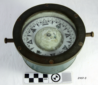 Flagstaff Hill Maritime Museum and Village
Compass, c. 1930s
The nautical compass is used for determining directions, using a free moving magnetised needle, indicating north and south. This is a medium sized compass and was suitable for mounting in a fixed brass binnacle or a portable wooden box. The compass fluid was typically lamp oil, or a mixture of alcohol and water. This compass, based on its pattern, was probably manufactured around the 1930s. The compass’s maker, Bergen Nautik, was a 20th Century compass manufacturer, making compasses from the 1900s but no longer in business.The factory was located in Hordaland County, Bergen, on the west coast of Norway. This compass is not a very significant marine item as it was made in the 20th century. Examples of the same compass that have been salvaged can be purchased today mounted either in a wooden box or a brass pedestal.Compass; marine or ship's compass, brass, gimbal mounting, in blue metal casing. Manufacturer’s inscription is on the face. Made by Bergen Nautik of Bergen in Norway. Circa 1930s."BERGEN . NAUTIK", "BERGEN", "NORWAY" flagstaff hill, warrnambool, shipwrecked coast, flagstaff hill maritime museum, maritime museum, shipwreck coast, flagstaff hill maritime village, great ocean road, compass, nautical compass, marine compass, maritime compass, technical instrument, navigation instrument, bergen nautik, 20th-century marine compass, gimbal compass, ship's compass, bergan nautik, norway, 1930s marine compass -
 Warrnambool and District Historical Society Inc.
Magazine - Project, Warrnambool: sandstone era of the eighties, 1973
Geographically situated on the coast Warrnambool has large tracts of sedimentary rock, some of which is sandstone. It therefore was a readily available material and as a relatively soft stone it was easily quarried and cut. By the 1880’s Warrnambool had been established for around forty years and was proving to be a settlement of some wealth. Hence the trend to build bigger and grander homes. There are numerous other commercial buildings which are built in sandstone and many of the original quarries are still visible around the Warrnambool area. Most of the properties are situated in the central part of Warrnambool. This collection of photographs is a good cross-section of some of the significant homes and buildings of Warrnambool. It also shows how they look 100 years after being built.A collection of 18 black and white photographs of sandstone houses, mounted on card and tied loosely with string. The addresses of each house are hand-written in black pen beside each photo. Title is written in black pen on cover page.Graeme Blake 1973 in bottom RH corner, Via * Fraser & Chris How in blue pencil.warrnambool, sandstone, sandstone houses, 1880 warrnambool -
 Flagstaff Hill Maritime Museum and Village
Clothing - Button, c. 1845
THE CATARAQUI The Cataraqui was built in 1840 in Quebec, Canada, and wrecked on 4th August, 1845 off the west coast of King Island, Australia. The lives of 400 people on the emigrant ship were lost. Many of them were on government assisted passages from Britain and Ireland. Only nine people, one passenger and eight crew, survived the shipwreck. A man who lived on the island, sheltered them and five weeks later the group was rescued by the ship Midge, which took them to Melbourne. It was the largest civilian maritime disaster.The button is significant as an example of a 19th century clothing accessory. The button is also significant for its association with the 1840 Canadian built ship, Cataraqui. The Cataraqui is significant in maritime history as Australia's largest civilian maritime disaster. The wreck also has a connection to the establishment of the Cape Otway lighthouse and to Warrnambool’s history as Superintendent Charles LaTrobe came to the Warrnambool district several times in an effort to find the best route to the Cape Otway area. While doing so he became familiar with the Warrnambool area and the need to establish a new settlement as Warrnambool.Metal button, vertical shank on back. Button experiencing corrosion and one edge has been eaten away. Inscription and two circular markings on shank side of button. Salvaged from the wreck of the Cataraqui.Unable to decipher.flagstaff hill maritime museum & village, shipwreck coast, great ocean road, button, king island, shipwreck, maritime disaster, cape otway, cataraqui -
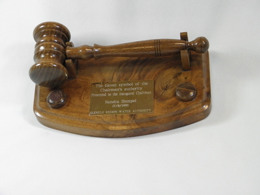 Wannon Water
Gavel, Brian Rowe, 1995
The gavel was presented by Russell Worland (Acting Secretary Glenelg Region Water Authority) to the inaugural chairman of the Glenelg Region Water Authority 1995, Sandra Hempel. Glenelg Region Water Authority amalgamated the previous authorities of Glenelg-Wannon Water Board, Hamilton Water Board, Shire of Dundas and Shire of Mount Rouse Water and Sewerage Authorities and was constituted on 1 July 1994. Glenelg Region Water Authority was then amalgamated with South West Water and Portland Coast Water to form Wannon Water on 1 July 2005.Presented to the first chairman of the newly constituted Glenelg Region Water Authority, a predecessor authority to Wannon WaterWooden turned gavel and a base carved from Konongwootong blackwood, a brass plaque with an inscription. The underneath of the base has an inscription detailing the craftsperson and origin of the wood.Top of the gavel base : "The gavel : symbol of the/ Chairman's authority/ presented to the inaugural Chairman/ Sandra Hempel /17/8/1995/ Glenelg Region Water Authority" Underneath of the gavel base : "Handcrafted by Bryan Rowe/ from Koonongwootong blackwood/ Hamilton August 1995"gavels -
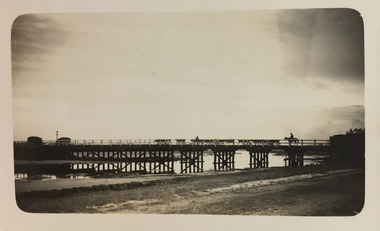 Kew Historical Society Inc
Photograph - Moyne River Bridge, c.1926
Henry Beater Christian (1886-1962) , was a descendant of one of the earliest settler families in Kew. Employed at the Kew Asylum as a 'public servant', he was a skilled amateur photographer, photographing numerous scenes in Kew and on his travels around Victoria. The majority of his photographs date from 1916 to 1929. His finest photographs are housed in two photograph albums. Digital copy of a photograph from page 24 of the 47-page photograph album containing 261 gelatinous silver images, loaned by Diane Washfold with permission given to digitise and hold a copy in our collection. In the 1920s, the photographer travelled throughout Victoria, including on the west coast from Port Campbell to Port Fairy. Trips were presumably made by train and by foot. Lynda Tieman and her team at the Port Fairy Historical Society have tentatively identified a number of Henry Christian's photographs of Port Fairy, of which this is one. The photo captures a man on a horse, believed to be Bill Digby, driving a herd of cattle across the Moyne River Bridge. The photo is shot into the man light source, leading to the bridge and those who cross it being shown in silhouette.henry beater christian (1886-1962), landscape photography, christian-washfold collection, photograph albums, moyne river bridge, port fairy (vic.), bill digby, cattle drovers