Showing 1137 items matching " dairy"
-
 Glen Eira Historical Society
Letter - Kangaroo Road, 48, Murrumbeena
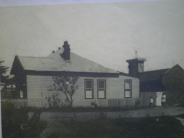
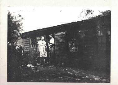
One black and white photograph (152mm x 210mm), undated and unattributed, of the exterior of the house at 48 Kangaroo Road, Murrumbeena with the Park View Dairy at the rear. Two unidentified persons are pictured. On the back of the photograph there is a faded, undecipherable handwritten name and address. The file also includes a copy of the same photograph. Also included is a one page typed letter, undated, from Kim Allen (nee Vickers) to the Glen Eira Historical Society, requesting a copy of the photograph of 48 Kangaroo Road, Murrumbeena. The file also includes a print-out of a one page email sent 03/06/2008, printed 06/06/2008, from John O’Callaghan to Kim Allen, providing a copy of the requested photograph. A copy of the printed email is also included.allen kim, vickers kim, vickers walter leonard, vickers olive emily sarah, o’callaghan john, park view dairy, murrumbeena, glen eira historical society, kangaroo road, timber houses, dairies -
 Kew Historical Society Inc
Photograph, Willsmere, circa 1965, c. 1965
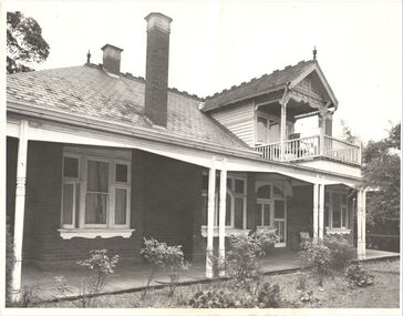
The historian Dorothy Rogers records (A History of Kew, p.5) that "In 1888 he [Arthur Wills] took over his estate, 'Willsmere', and conducted it as a dairy farm. He was an architect by profession, and having established the farm he rented it, and returned to live in Barry Street, Kew, where his only child, Dorothy was born in 1889. He entered Kew Council in 1891, and three years later built a new house in Fellows Street, on land that Thomas had purchased at the 1846-47 sales. He became Mayor of Kew in 1896-97, and during his term of office sold this house and built the present 'Willsmere' [pictured] on the corner of Willsmere and Belford Roads. ... Never a house of great distinction, it has now been demolished to make way for a freeway."This work forms part of the collection assembled by the historian Dorothy Rogers, that was donated to the Kew Historical Society by her son John Rogers in 2015. The manuscripts, photographs, maps, and documents were sourced by her from both family and local collections or produced as references for her print publications. Many were directly used by Rogers in writing ‘Lovely Old Homes of Kew’ (1961) and 'A History of Kew' (1973), or the numerous articles on local history that she produced for suburban newspapers. Most of the photographs in the collection include detailed annotations in her hand. The Rogers Collection provides a comprehensive insight into the working habits of a historian in the 1960s and 1970s. Together it forms the largest privately-donated collection within the archives of the Kew Historical Society.Willsmere, the home of the Wills family of Kew, designed by the architect Arthur Wills, circa 1896. arthur wills, willsmere, belford road, willsmere road, dorothy rogers, kew, wills family -
 Kew Historical Society Inc
Photograph - Yarra Valley Floods: Kew East, 1916
Flooding of the Yarra Valley, including that section of the Yarra bordering Kew and Kew East in the north and west of the municipality, was a regular occurrence. Extreme flood events of the Yarra River are recorded to have occurred in 1891, 1901, 1916, 1923 and 1934. The Municipality of Kew's response to these floods was to enact planning decisions restricting residential development in flood prone areas following the floods of 1916, 1921 and 1934. While floods continued after the development of the Upper Yarra Reservoir (construction 1948-57), the regularity and extent of these inundations diminished. During the nineteenth century, the land abutting the south side of the Yarra in Kew was devoted to dairy farming. In the twentieth century, before and after the construction of the Eastern Freeway, much of this low-lying area was used as golf courses and public parks.One of a collection of photographs of flooding in the Kew section of the Yarra Valley which are in important research resource for the location and extent of flooding in the first half of the twentieth century. Flooding of the Yarra Valley at East Kew in 1916. The view is taken from the intersection of Kilby Road with what is believed to be Birdwood Street, looking across the flood waters to Ivanhoe. The extensive flooded area shown in the photograph would have included the Kew Golf Club. Verso: "Floods along Kilby Road / near Birdwood St? & Kilby Road / 1917? / 87yarra river, yarra valley, floods -- kew, kilby road -- kew (vic.), kew golf club -
 Kew Historical Society Inc
Photograph - Flooding of the Yarra Valley at Kew East, 1974
Flooding of the Yarra Valley, including that section of the Yarra bordering Kew and Kew East in the north and west of the municipality, was a regular occurrence. Extreme flood events of the Yarra River are recorded to have occurred in 1891, 1901, 1916, 1923 and 1934. The Municipality of Kew's response to these floods was to enact planning decisions restricting residential development in flood prone areas following the floods of 1916, 1921 and 1934. While floods continued after the development of the Upper Yarra Reservoir (construction 1948-57), the regularity and extent of these inundations diminished. During the nineteenth century, the land abutting the south side of the Yarra in Kew was devoted to dairy farming. In the twentieth century, before and after the construction of the Eastern Freeway, much of this low-lying area was used as golf courses and public parks.Late example of the capacity of the Yarra Valley at Kew to flood, even though drainage works and the Upper Yarra Reservoir had reduced their regularity.Original black and white print photograph of the low-lying land at East Kew under floodwater on 16 May 1974. The vantage point of the photographer is Lister Street. In the photo, the fences of the Kilby Farm can be seen. Flooding was caused by overflowing water in Glass' Creek and the River Yarra. Annotation verso: "Hay's Paddock op No.30 Lister Street / 16 May 1974 11.50am / R.L. 46.04"hays paddock, floods, yarra river, glass' creek, lister street -
 Kew Historical Society Inc
Photograph - Flooding of the Yarra Valley at Kew East, 1974
Flooding of the Yarra Valley, including that section of the Yarra bordering Kew and Kew East in the north and west of the municipality, was a regular occurrence. Extreme flood events of the Yarra River are recorded to have occurred in 1891, 1901, 1916, 1923 and 1934. The Municipality of Kew's response to these floods was to enact planning decisions restricting residential development in flood prone areas following the floods of 1916, 1921 and 1934. While floods continued after the development of the Upper Yarra Reservoir (construction 1948-57), the regularity and extent of these inundations diminished. During the nineteenth century, the land abutting the south side of the Yarra in Kew was devoted to dairy farming. In the twentieth century, before and after the construction of the Eastern Freeway, much of this low-lying area was used as golf courses and public parks.Late example of the capacity of the Yarra Valley at Kew to flood, even though drainage works and the Upper Yarra Reservoir had reduced their regularity.Original black and white print photograph of the low-lying land at East Kew under floodwater on 16 May 1974. The vantage point of the photographer is Lister Street. Flooding was caused by overflowing water in Glass' Creek and the River Yarra. Annotation verso: "Lister Street looking north / Flood level / 16 May 1974 11.30am / R.L. 46.04"hays paddock, floods, yarra river, glass' creek, lister street -
 Kew Historical Society Inc
Photograph - Flooding of the Yarra Valley at Kew East, 1974
Flooding of the Yarra Valley, including that section of the Yarra bordering Kew and Kew East in the north and west of the municipality, was a regular occurrence. Extreme flood events of the Yarra River are recorded to have occurred in 1891, 1901, 1916, 1923 and 1934. The Municipality of Kew's response to these floods was to enact planning decisions restricting residential development in flood prone areas following the floods of 1916, 1921 and 1934. While floods continued after the development of the Upper Yarra Reservoir (construction 1948-57), the regularity and extent of these inundations diminished. During the nineteenth century, the land abutting the south side of the Yarra in Kew was devoted to dairy farming. In the twentieth century, before and after the construction of the Eastern Freeway, much of this low-lying area was used as golf courses and public parks.Late example of the capacity of the Yarra Valley at Kew to flood, even though drainage works and the Upper Yarra Reservoir had reduced their regularity.Original black and white print photograph of Hay's Paddock under floodwater on 16 May 1974. The vantage point of the photographer is Keystone Crescent looking east. Flooding was caused by overflowing water in Glass' Creek and the River Yarra. Annotation verso: "Keystone Cr looking east / 16 May 1974 11.50am"hays paddock, floods, yarra river, glass' creek -
 Kew Historical Society Inc
Photograph - Flooding of the Yarra Valley at Kew East, 1974
Flooding of the Yarra Valley, including that section of the Yarra bordering Kew and Kew East in the north and west of the municipality, was a regular occurrence. Extreme flood events of the Yarra River are recorded to have occurred in 1891, 1901, 1916, 1923 and 1934. The Municipality of Kew's response to these floods was to enact planning decisions restricting residential development in flood prone areas following the floods of 1916, 1921 and 1934. While floods continued after the development of the Upper Yarra Reservoir (construction 1948-57), the regularity and extent of these inundations diminished. During the nineteenth century, the land abutting the south side of the Yarra in Kew was devoted to dairy farming. In the twentieth century, before and after the construction of the Eastern Freeway, much of this low-lying area was used as golf courses and public parks.Late example of the capacity of the Yarra Valley at Kew to flood, even though drainage works and the Upper Yarra Reservoir had reduced their regularity.Original black and white print photograph of the low-lying land at East Kew under floodwater on 16 May 1974. The vantage point of the photographer is Lister Street. Flooding was caused by overflowing water in Glass' Creek and the River Yarra. Annotation verso: "Lister St looking same as No.3 / 16 May 1974 11.30"floods, yarra river, glass' creek, lister street -
 Kew Historical Society Inc
Photograph - Flooding of the Yarra Valley at Kew East, 1974
Flooding of the Yarra Valley, including that section of the Yarra bordering Kew and Kew East in the north and west of the municipality, was a regular occurrence. Extreme flood events of the Yarra River are recorded to have occurred in 1891, 1901, 1916, 1923 and 1934. The Municipality of Kew's response to these floods was to enact planning decisions restricting residential development in flood prone areas following the floods of 1916, 1921 and 1934. While floods continued after the development of the Upper Yarra Reservoir (construction 1948-57), the regularity and extent of these inundations diminished. During the nineteenth century, the land abutting the south side of the Yarra in Kew was devoted to dairy farming. In the twentieth century, before and after the construction of the Eastern Freeway, much of this low-lying area was used as golf courses and public parks.Late example of the capacity of the Yarra Valley at Kew to flood, even though drainage works and the Upper Yarra Reservoir had reduced their regularity.Original black and white print photograph of the low-lying land at East Kew under floodwater on 16 May 1974. The vantage point of the photographer is at Willsmere Road. The road itself is underwater.Annotation verso: "Willsmere Rd / Same as No.7 / 16 May 1974 11.15am"floods, yarra river, willsmere road -
 Kew Historical Society Inc
Photograph - Flooding of the Yarra Valley at Kew East, 1974
Flooding of the Yarra Valley, including that section of the Yarra bordering Kew and Kew East in the north and west of the municipality, was a regular occurrence. Extreme flood events of the Yarra River are recorded to have occurred in 1891, 1901, 1916, 1923 and 1934. The Municipality of Kew's response to these floods was to enact planning decisions restricting residential development in flood prone areas following the floods of 1916, 1921 and 1934. While floods continued after the development of the Upper Yarra Reservoir (construction 1948-57), the regularity and extent of these inundations diminished. During the nineteenth century, the land abutting the south side of the Yarra in Kew was devoted to dairy farming. In the twentieth century, before and after the construction of the Eastern Freeway, much of this low-lying area was used as golf courses and public parks.Late example of the capacity of the Yarra Valley at Kew to flood, even though drainage works and the Upper Yarra Reservoir had reduced their regularity.Original black and white print photograph of the low-lying land at East Kew under floodwater on 16 May 1974. The photograph is of Hyde Park looking north-east.Annotation verso: "Hyde Park looking nth-east / Flood Level / 16 May 1974 11.15am / R.L. 46.61"floods, yarra river, hyde park -
 Kew Historical Society Inc
Photograph - Flooding of the Yarra Valley at Kew, 1974
Flooding of the Yarra Valley, including that section of the Yarra bordering Kew and Kew East in the north and west of the municipality, was a regular occurrence. Extreme flood events of the Yarra River are recorded to have occurred in 1891, 1901, 1916, 1923 and 1934. The Municipality of Kew's response to these floods was to enact planning decisions restricting residential development in flood prone areas following the floods of 1916, 1921 and 1934. While floods continued after the development of the Upper Yarra Reservoir (construction 1948-57), the regularity and extent of these inundations diminished. During the nineteenth century, the land abutting the south side of the Yarra in Kew was devoted to dairy farming. In the twentieth century, before and after the construction of the Eastern Freeway, much of this low-lying area was used as golf courses and public parks.Late example of the capacity of the Yarra Valley at Kew to flood, even though drainage works and the Upper Yarra Reservoir had reduced their regularity.Original black and white print photograph of the low-lying land at East Kew under floodwater on 16 May 1974. The photograph is taken from 43 Kellett Grove.Annotation verso: "Kellett Gve No.43 / Flood Level / 16 May 1974 11.40am"floods, yarra river, kellett grove -
 Surrey Hills Historical Society Collection
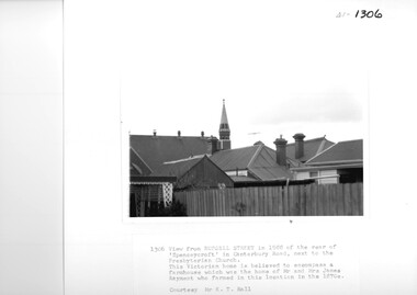
Photograph, View from Russell Street, of the rear 'Spencecroft' in 1988
Spenceycroft was home of James and Elizabeth Rayment, who had a dairy farm in the area in the 1870s. The house was located in Canterbury Road next to the Surrey Hills Presbyterian Church. For many years, it was hidden behind a large fence sheltering it from the noise of traffic along Canterbury Road. It has been claimed that it incorporated part of the original farmhouse built on the site by George Klepper, who planted a vineyard in the area. George’s family was one of a number of German families who settled in Surrey Hills during the later part of the 19th century. In recent years Spenceycroft was sold several times and became increasingly derelict. Since its last sale, it has been demolished. Some of the above may be in error. Research is currently being undertaken to authenticate claims previously asserted.A black and white photograph of the rear of some buildings from Russell Street, at the rear of 'Spencecroft'.house names, spenceycroft, spencecroft, russell street, surrey hills, james rayment, (mrs) elizabeth rayment -
 City of Moorabbin Historical Society (Operating the Box Cottage Museum)
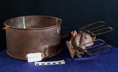
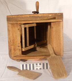
Kitchen Equipment, Mechanical Cake mixer c 1890, c1880
A mixer is a kitchen utensil which uses a gear-driven mechanism to rotate a set of beaters in a bowl containing the food to be prepared. It automates the repetitive tasks of stirring, whisking or beating. Mixers for the kitchen first came into use midway through the nineteenth century; the earliest were mechanical devices. The mixer with rotating parts was patented in 1856 by Ralph Collier a tinsmith in Baltimore, Maryland .This was followed by E.P. Griffith's whisk patented in England in 1857. A circular tin used for mixing batters. The 2 beaters are of wire, with metal gears, suspended from a metal strip that fits over the tin bowl. and is clamped into place by a metal screw . A crank handle with a wooden black knob attached by a screw is turned by hand to mix the batter in the base. This tin could be secured to a table by a clamp and screw. cooking, kitchen equipment, dairy, cakes, housework, early settlers, pioneers, baking, nutrition, blacksmiths, market gardeners, cake mixers, moorabbin, cheltenham, bentleigh, brighton -
 Whitehorse Historical Society Inc.
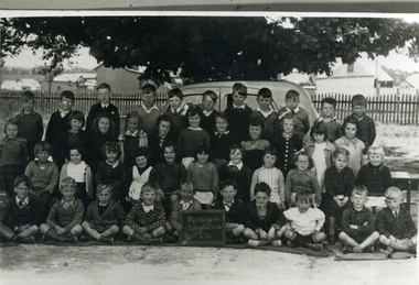
Photograph, Prep - Mitcham Primary - 1940, 1940
Black and white photograph of Prep grade (Grade 1A) of Mitcham Primary School in 1940. Davin's Dairy and stable in background at corner of Mitcham Road and Victoria Street. Back row - ????Sargeant, David McLean, ???????, John Robertson, Keith Jones, Herb Lilburn, Dave Jones, Jeff Ellis, Alfred Gadsen. 2nd Row - Dawn freeman, Clare Smith, Barbara Savage, Keitha Petty, Marjory Stonehorn, Judith Honeybun, ??????, Pat Flynn, Peggy Burns, Betty Dashwood, Norma Hennessy. 3rd Row - Thelma Burton, Irene Schafer, Robin Leeworthy, Maureen Webster, Barbara Spelling, Margaret Newing, Judith Gorsuch, Lorna Treverton, Valda Hancock, Marion Cumming, ??? Taylor. Front Row - Bill McCaulay, Graham Clements, John Colman, Vernon Osterlind, Arthur Charles, ???? Boyle, Keith Brown, Alan Smith, Micky Dee, Lawrence Petty.mitcham primary school, no. 2904, sargeant, lilburn, herb, jones, keith, robertson, john, mclean, david, dave, ellis, jeff, gadsen, alfred, freeman, dawn, hennesy, norma, dashwood, betty, burns, peggy, flynn, pat, honeybun, judith, stonehorn, marjory, petty, keitha, savage, barbara, burton, thelma, smith, clare, schafer, irene, taylor, cumming, marion, hancock, valda, treverton, lorna, gorsuch, newing, margaret, spelling, webster, maureen, leeworthy, robin, bill mccaulay, fry, lawrence, dee, micky, alan, brown, boyle, charles, arthur, osterlund, vern, colman, clements, graham -
 Kew Historical Society Inc
Photograph, J F C Farquhar, Studley Park Road, 1891
At the beginning of the 1890s, the Kew businessman and Town Councillor, Henry Kellett, commissioned J.F.C. Farquhar to photograph scenes of Kew. These scenes included panoramas as well as pastoral scenes. The resulting set of twelve photographs was assembled in an album, Kew Where We Live, from which customers could select images for purchase.The preamble to the album describes that the photographs used the ‘argentic bromide’ process, now more commonly known as the gelatine silver process. This form of dry plate photography allowed for the negatives to be kept for weeks before processing, hence its value in landscape photography. The resulting images were considered to be finely grained and everlasting. Evidence of the success of Henry Kellett’s venture can be seen today, in that some of the photographs are held in national collections.It is believed that the Kew Historical Society’s copy of the Kellett album is unique and that the photographs in the book were the first copies taken from the original plates. It is the first and most important series of images produced about Kew. The individual images have proved essential in identifying buildings and places of heritage value in the district.In this view of Studley Park Road, looking northeast to the Junction, the photographer invites the viewer to participate in a point-of-view that emphasises the elevated, tranquil vantage point of the hill in contrast to the bustling commercial area in the distance. The view emphasises the exclusiveness of Studley Park, with its high fences behind which a number of significant Kew mansions were concealed. Contemporary advertisements for the sale of mansions in Studley Park Road often included fulsome descriptions of their elaborate formal gardens, as well as paddocks for grazing, stabling and dairies. None can be seen here. The use of high, protective wooden pickets to surround the newly planted avenue of elms on the south side of the road appears to be typical of the period. Similar examples can be seen in early photographs of Wellington and Princess Streets.The horse and carriage, selected as a central focus of the view, reinforces the residential, exclusive nature of this part of Kew in the early 1890s. Studley Park Roadkew illustrated, kew where we live, photographic books, henry kellett -
 City of Moorabbin Historical Society (Operating the Box Cottage Museum)
Newsletter - CMHS February 2014 pdf, February 2014
The City of Moorabbin Historical Society was formed c 1960 by a group of Moorabbin area residents who were concerned that the history of the area should be preserved. A good response to a call for items related to the historical area of Moorabbin Shire brought donations of a wide variety of artefacts that are now preserved by the current members of CMHS at Box Cottage Museum. Helen Stanley, Secretary of CMHS, began producing a Newsletter for members in April 2007 to provide current information and well researched items of historical interest. Jim Dale continued to produce the Newsletter in 2013 after Helen resigned.5 x A4 paper pages printed on one side with colour photograph, Jim Dale, President, welcomes members to the February 23rd Meeting at Box Cottage and acknowledges Anne Caprackas as Secretary and Dr Bill Richardson is now Treasurer. Jim will have a Stall at the Moorabbin Primary School Fete in March. Jim went to a meeting to discus plans for 2015 Commemoration of the Great War in Glen Eira. Members Bill, David, Daryl Carol, Joan collected and installed a large Display Cabinet in the Dairy on December 19th and Dennis fitted castors to it in January. Jim was present on February 3rd when members of the Harry Hawker family presented a memento to the Victorian Governor, His Excellency Alex Churnov The next Meeting will be March 30th Jim Dale attached the Final Part of his report 'The Allynson's of East Bentleigh' about 'The Petrov Affair 1954'City of Moorabbin Historical Society Newsletter February 2014ity of moorabbin historical society, stanley helen, dale jim, melbourne, moorabbin, brighton, cheltenham, ormond, bentleigh, market gardeners, pioneers, early settlers, east bentleigh, city of kingston, vladimir mickalovick petrov, evodika petrov, michael thwaites, maria allynson, sven allynson, kgb, mvd, asio, ‘petrov affair’, darwin airport, mascot airport, col. charles spry, cold war 1950 -
City of Moorabbin Historical Society (Operating the Box Cottage Museum)
Newsletter - City of Moorabbin Historical Society April 2013 doc, April 2013
The City of Moorabbin Historical Society was formed c 1960 by a group of Moorabbin area residents who were concerned that the history of the area should be preserved. A good response to a call for items related to the historical area of Moorabbin Shire brought donations of a wide variety of artefacts that are now preserved by the current members of CMHS at Box Cottage Museum. Helen Stanley, Secretary of CMHS, began producing a Newsletter for members in April 2007 to provide current information and well researched items of historical interest Helen retired in 2012 and Dr Bill Richardson, Secretary CMHS produced this NewsletterDr Bill Richardson, Secretary, has taken on the role of producing the bimonthly Newsletter for CMHS following the resignation of Helen Stanley. The Victorian Government Legislation has a new set of Model Rules that we have been invited to adopt and modify if we feel necessary. Our conclusion is that the new Model Rules are generally comprehensive and adequate, and are simple to understand. We recommend that the new model rules be adopted with some possible additions.A4 paper x 2 pages printed on one side. This is the first of the bi-monthly, City of Moorabbin Historical Society Newsletter produced by Society member and Secretary, Dr. Bill Richardson in April 2013. YouTube video of the Cottage is up and running. Type Box Cottage in search engine. City of Glen Eira properties staff inspected Cottage, found all ok and organised some photographs for the Glen Eira residents’ handbook. Dennis has installed the new display cabinets that he built for the barn for the tools that were displayed in the dairy. This was funded by CGE Community Grant . We will need to decide on the Model Rules and our purposes as required by the new Victorian Government legislation. The next general meeting is on 28th April at 1:00pm .Membership fees for 2013 are due and payable. Volunteers will be needed on Friday 26th April City of Moorabbin Historical Society Inc. / Reg. No. A0020547E / Box Cottage Museum/ Joyce Park, Jasper Road, Ormond / Secretary: Dr Bill Richardson / Secretary's News / April 2013victorian government, incorporated associations, dale james, stanley helen, maynard dennis, richardson bill, newsletters, moorabin, bentleigh, ormond, cheltenham -
 The Beechworth Burke Museum
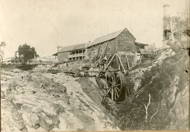
Photograph, 1859
Louis Chevalier, brother of popular artist Nicholas Chevalier, opened a sawmill in Beechworth near Spring Creek in Newtown in 1853. This facilitated a boom in building in the town, as materials were much more available than they had been previously. A second sawmill was opened in the town in 1856. Louis Chevalier served on the Beechworth Council as a representative of Newtown between 1858 and 1860. As this photograph is taken in 1859, the mill would have been operating as a sawmill at the time this photograph was taken. Louis Chevalier’s mill stopped sawing wood and began milling flour at some point between 1860 and 1862. At this time, the Oven’s district was almost self-sufficient, producing considerable quantities of grain, dairy, fodder and meat. Unfortunately, the region experienced poor agricultural yields in the 1880s and 1890s, which lead to the closure of the Beechworth Flour Mills in the 1880s. This photograph depicts the first sawmill in Beechworth, which was responsible for making the materials available for other early buildings in the town. The mill race and wheel are also clearly depicted, which may shed light onto how mill wheels of this era and place were constructedBlack and white rectangular photograph printed on matte photographic paper mounted on boardReverse: 3146 / 1997.2654 / Louis Chevalier's Flour Mill on / the Newtown Falls before the / Bridge / Est 1853 / this photo 1859 / 84-229-1 / Burke Museum Beechworth / Page 41 / 81 % / (Illegible) / (Illegible) 14 / chevalier, louis chevalier, newtown, mill, grain mill, sawmill, flour mill, 1850s beechworth, beechworth council, farming and agriculture, victorian agricultural history, spring creek, buildings, industry, forestry, wood, timber -
 Warrnambool and District Historical Society Inc.
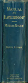
Book, Manual of Bacteriology, 1927
This book was a text book used by Arthur Gregory, the test room technician at Warrnambool Cheese and Butter Factory in the 1930s. He tested the suppliers’ milk and cream for butterfat percentage in order to determine the payment to the suppliers. Arthur Gregory later became the manager of Jays Laundry in Fairy Street. In the 1930s Arthur Gregory boarded at 28 Spence Street in Warrnambool. This boarding house was run by May Taggart, the wife of Sam Taggart, a Warrnambool tailor. Les O’Callaghan was also a boarder there and it was through his contact with Arthur Gregory that he obtained the position of laboratory technician at the Warrnambool Cheese and Butter Factory. Les O’Callaghan remained for over 40 years at this factory (leased at that time by the Kraft company) and was very important in the development of laboratory techniques used in the dairy industry. The Warrnambool Cheese and Butter Factory was established at Allansford in 1888 and is still in production today, operated by the Canadian firm of Saputo. This book is of interest because of its connection to Arthur Gregory, a test room technican at the Warrnambool Cheese and Butter Factory in the 1930s and to Les O’Callaghan, the Laboratory Manager and Microbiologist at Warrnambool Cheese and Butter Factory for more than 40 years. This is a hard cover book of 822 pages. It has a blue cover with gold lettering on the spine. It has 29 chapters, an appendix, a bibliography and an index. It has many black and white illustrations and drawings. The spine is slightly scuffed. The inscription is handwritten in pencil. ‘A.S.Gregory 28 Spence Street W’bool’ warrnambool cheese and butter factory, arthur gregory, warrnambool, les o’callaghan, warrnambool, history of warrnambool -
 Orbost & District Historical Society
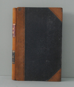
ledger, 1. 8. 1915 - 30 .6. 1923
This ledger was kept by the management of a rural property in Marlo, East Gippsland. Entries were made by Hugh Cameron and Alaster Cameron. Their property was reputed to be the largest private dairy producer in Australia at one stage. (ref. Mary Gilbert) Some station owners or managers kept records like diaries, wage and ration books, and registers of births, deaths and marriages. This one records federal transactions, costs of produce and payments for share farming at Brodribb and Marl, as well as a list of donations made. Hugh Cameron (1850-1921) was on the Orbost Shire council from 1892-1915. His son Alaster was also an Orbost Shire councillor representing the East riding from 1932 to 1954. Hugh died at Orbost on 3rd May 1921, aged 71, and was buried on 5th May at the Orbost cemetery. (more info. in O.D.H.S. newsletter -Tambo Shire)This is an example of record keeping on rural properties in the first half 20th century. It is associated with the Cameron family who were early settlers in the Orbost district.A large leather bound ledger with a dark blue patterned cover and suede leatherette binding and corners. There are pages with alphabetical indexing. Some pages are ruled for accounts. All entries are hand-written in blue or black ink.There is blotting paper inside.on spine on red leatherette in gold print - " "STATION LEDGER" and on black in gold print - "CLOVERDALE"cameron-marlo dairy-farm-cameron agriculture-records station-ledger-cameron -
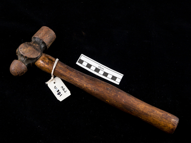 City of Moorabbin Historical Society (Operating the Box Cottage Museum)
Tool - Hammer, Ball & Peen , metal wood c1900, c1900
Among the early settlers in Moorabbin Shire were blacksmiths who made tools for the other settlers who were establishing the homes, market gardens, farms, orchards and various businesses. Early settlers were self reliant and repaired their own equipment for kitchen,dairy, farm, horses, carts using various tools . Besides for peening (surface hardening by impact), the ball-peen hammer is useful for many tasks, such as striking punches and chisels - usually performed with the flat face of the hammer. The peening face is useful for rounding off edges of metal pins and fasteners, such as rivets. The ball face of the hammer can also be used to make gaskets for mating surfaces. A suitable gasket material is held over the surface where a corresponding gasket is desired, and the operator will lightly tap around the edges of the mating surface to perforate the gasket materialThis hammer is typical of the type used by early settlers in Moorabbin Shire c1900A hard faced ball & peen hammer, also known as a machinist's hammer,[ is a type of peening hammer used in metalworking. It has two heads, one flat and the other, called the peen, rounded.early settlers, market gardeners, blacksmiths, tools, building equipment, hammers, moorabbin shire, bentleigh, mckinnon, highett, cheltenham,mcewan james pty ltd, melbourne, bunnings pty ltd, -
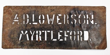 Myrtleford and District Historical Society
Tobacco bale stencil
Stencil used by Sgt. Albert David Lowerson, VC, a soldier settler on Merriang Estate near Myrtleford. Lowerson acquired one of 19 blocks assigned by the Closer Settlement Board on the 700 acre estate in 1920. The stencil marked bales of cured tobacco leaves prior to shipment to Melbourne. Lowerson was one of the few successful soldier settler farmers in the district, operating a piggery, dairy farming and growing tobacco for almost 20 years on "St. Quentin". (Lowerson was awarded the Victoria Cross at Mont St. Quentin on September 1, 1918.) His success and status enabled him to lead a submission on farm debt and infrastructure problems when the soldier settlement scheme was being reviewed at government level. He was active locally on these issues and supported fund raising for a war memorial, memorial hall and veteran welfare.The stencil represents the achievements of A.D.Lowerson, VC as an isolated example of success as a WW1 soldier settler and as a local identity who stridently supported the need for recognition and support of ex-service personnel.Stencil made of thin sheet metal, rusted .Wording of stencil "A.D.LOWERSON. MYRTLEFORD." lowerson a.d., merriang estate, myrtleford, closer settlement board, tobacco, st. quentin, victoria cross, world war 1 -
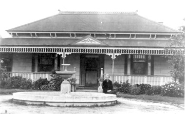 Surrey Hills Historical Society Collection
Photo, 'Spenceycroft', Canterbury Road
The photo is of ‘Spenceycroft’ at 654 Canterbury Road, Surrey Hills. For many years this home was hidden behind a large fence sheltering it from the noise of traffic along Canterbury Road, however it dates back to the very early days of settlement in the Surrey Hills area. Canterbury Road was then known as Delany’s Road. ‘Spenceycroft’ is thought to incorporate part of the original farmhouse built on the site by George Klepper, who planted a vineyard in the area. George’s family was one of a number of German families who settled in Surrey Hills during the later part of the 19th century. Later, the land associated with ‘Spenceycroft’ was worked as a dairy farm by James and Elizabeth Rayment. In recent years 'Spenceycroft' has been sold several times and has become increasingly derelict. Sold again in 2015 when it had become quite derelict, it was demolished and re-developed.A black & white photo of double-fronted Victorian style home with a fountain centre front and low foliage in front of the veranda. A woman is sitting by the fountain. 'spenceycroft', canterbury road, james rayment, elizabeth rayment, george klepper -
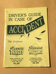 Surrey Hills Historical Society Collection
Booklet - Advertising booklet, Driver's guide in case of accident, c1991
Surrey Panels was started by Maurice Dalzell (Maurie) Costello (1918-2000) in 1948, soon after the first Holden was released. Maurie later brought his sons Alan, Robert and Brian into the business. F H Stevens Motors started in North Balwyn at a similar time and in 1982 was taken over by the Costello brothers, with Robert as General Manager. Members of the Costello family have been around the Surrey Hills area for many decades. Maurie’s parents Thomas Maurice and Mabel Isabel Costello lived at 43 Box Hill Crescent, Mont Albert North. Thomas was a cattle dealer and related to the Costellos of Costello’s Jersey Dairy (demolished) in Mont Albert Road, Balwyn. Prior to starting the business Maurie is listed as a market gardener living with his parents in Box Hill Crescent. He married Mavis Jean Guillerme in 1942. Surrey Motors and Surrey Panels are well known businesses serving the Surrey Hills community for decades.A small booklet, yellow in colour, designed to fit in the glove box of a car. It is stapled on the spine in 2 places and consists of 12 pages. Some pages are designed for the owner to fill in with their personal details. There is advice regarding emergency phone calls, what to do in the event of an accident, towing, 'at fault' information, insurance, location and services of Surrey Panels and F H Stevens Motors. There is a brief history of these linked businesses. There is a separate loose sheet designed to be completed in the event of an accident.Nilsurrey motors, surrey panels, maurice dalzell (maurie) costello, f h stevens motors, alan costello, robert costello, brian costello, canterbury road, stirling crescent, surrey hills, ephemera, car accidents, motor vehicle repairs -
 Linton and District Historical Society Inc
Photograph, Joe Reidy and Stella Pearse, undated
The house is identified in the early LDHS index to photographs as being "Joe and Stella Reidy's home on Geelong Road" (Geelong Road now called Linton-Naringhil Road). Joe Reidy and Stella Pearse married in 1938. Information provided in 2025: "Joe and Stella out the back of their house. It has a flat roof on the back verandah and a normal peaked roof on the house. The house is on Naringhil Rd opposite side of road to Linton Park and back towards Linton. It used to have a foot bridge over the small creek, but now it has a pipe and driveway. At the back of the house is an old dairy where Joe would milk the cows morning and night after working the day for the Shire. The small foot bridge had decorative pine cones along it. Lovely garden etc. Joe was also Captain of the fire brigade for a long time." Enlarged black and white copy of original photograph, which has been mounted on white card. The photograph shows a young woman and young man standing outside a timber cottage. On card attached to bottom of photograph: "Joe Reidy and Stella Pearse (Mick Chung was born in this house.)"joe reidy, stella reidy nee pearse -
 University of Melbourne, Burnley Campus Archives
Album - Digitised, Joanne Morris, Visit to Burnley April 2014, 2014
Collection of digitised photographs taken in preparation for the Class of 1973 Reunion in 2014. Garden views and buildings. Donated by Joanne Morris, former student, in June 2014. See Digitised photos- Garden Views folder- Visit to Burnley April 2014. (1) Luffmann Ponds. (2) Administration Building. (3) Emily Gibson Beds and Ginkgo biloba. (4) Looking towards Native Garden. (5) Oak tree. (6) Looking towards Rose Garden. (7) Looking towards Stream Garden and Fern Garden. (8) Looking towards Rose Garden. (9) Plaque at entrance to Field Station. (10) New gates at entrance to Field Station donated by the Friends of Burnley Gardens. (11, 12) Field Station. (13) Plaque in Herb Garden commemorating Enid Carberry. (14) Fountain in Herb Garden commemorating Enid Carberry. (15) Forestry Building. (16-18) Inside Forestry Building. (19) Sugar Gum Table Setting donated by the Friends of Burnley Gardens. (20) Plaque on Sugar Gum Table commemorating Geoff Olive. (21, 22) View of Luffmann Ponds and Summer House. (23) Plaque at Luffmann Ponds. (24) Luffmann Ponds. (25) View of former Egg-Curator's Residence from Nursery. (26) Back of Nursery. (27,28) The Burnley entry for the Melbourne International Flower and Garden Show 2014. (29) Back of Administration Building. (30) Plant Science Laboratories. (31) Student Amenities Building. (32-34) Plant Science Laboratories. (35) Citriodora Court. (36) Eucalyptus maculata at entrance to Native Garden. (37) Native Garden, James Hitchmough Grasslands. (38) Garden view. (39) Inside the Hall. (40,41) Roof Garden. (42,43) Library. (44-50) Views of the Quad and classrooms. (51) Dairy. (52) Building 904,(Centre for Urban Horticulture) now Waterway Ecosystem Research Group. (53) Yarra Boulevard entrance.class 1973, class reunion, garden views, buildings, joanne morris, students, luffmann ponds, administration building, emily gibson beds, ginkgo biloba, native garden, oak tree, rose garden, stream garden, fern garden, field station, friends of burnley gardens, plaques, herb garden, enid carberry, fountain, forestry building, sugar gum table, geoff olive, summer house, egg-curator, residence, nursery, melbourne international flower and garden show, 2014, plant science laboratories, student amenities building, citriodora court, eucalyptus, james hitchmough grasslands, roof garden, library, quad, classrooms, dairy, centre for urban horticulture, waterway ecosystem research group, yarra boulevard entrance -
 City of Moorabbin Historical Society (Operating the Box Cottage Museum)
Functional object - Butter churn domestic, circa 1800s
Circa late 1800s. Wooden domestic butter-churn. This is a paddle churn, a barrel that contains a paddle, which is operated by a handle. The paddle churned the butter inside the container when the handle was turned. Early settlers had to be self sufficient, growing their own vegetables, making tools and clothing and usually had a house cow to produce their milk supply. An unsigned note states it was used by a Chinese market-gardener’s family. From the mid 1800s into the1900s, there were numbers of Chinese market gardeners working in Bentleigh, Moorabbin, Mc Kinnon, and Cheltenham in the Shire of Moorabbin. After the sale of land following 'Dendy's Special Survey' 1841 many Chinese settlers rented allotments and established market gardens in the area and sold their produce to the increasing population of Melbourne at the markets in St Kilda and Melbourne.Circa late 1800s. Wooden domestic butter-churn consisting of a wooden barrel with a lid and a crank that manually turned a paddle inside to separate the butter fat from the butter milk 'BUTTER CHURN' written in chalk undated, unsignedchinese, melbourne, brighton, moorabbin, butter, cows, milk, pioneers, dairy, settlers, fruit, bentleigh, markets, mckinnon, cheltenham, vegetables, dendy henry -
 City of Moorabbin Historical Society (Operating the Box Cottage Museum)
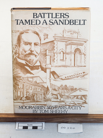
Book, Thomas Arthur Sheehy, Battlers Tamed A Sandbelt : Moorabbin 50 years a city, 1985
A hard cover book 192pp, published and printed in City of Moorabbin 1985.non-fictionmoorrabbin, brighton, cheltenham, bentleigh, ormond, market gardeners, early settlers, pioneers, mckinnon, highett, dairy, farming, moorabin shire, city of moorabbin, craftwork, blacksmiths, box cottage museum -
 Eltham District Historical Society Inc
Photograph, Peter Pidgeon, Grave of John and Mary Murray, Eltham Cemetery, Victoria, 5 April 2021
Irish-born John Murray and his wife Mary (daughter of Thomas Sweeney) married in 1849 and settled in Eltham North. John and Mary were amongst the earliest inhabitants of Eltham. John was a farmer and their block of about 80 acres, called ‘Laurel Hill’, was on the eastern side of the Diamond Creek, extending east to beyond Zig Zag Road. It was later extended southward by the purchase of a further 60 acres. He is recorded as a supporter on the petition for a school in Eltham and he served on the National School Board of the Eltham school. John died in 1867 and is buried in Eltham Cemetery with Mary and with two of their grandchildren. Their eldest son Johnnie inherited the property. Then in about 1902 his younger brother James purchased about 50 acres on the western side of the Diamond Creek immediately opposite Laurel Hill, extending west to slightly past Wattletree Road. Eltham North Reserve now lies just beyond the southern boundary. James built a family home on top of the hill on the northern boundary, together with a dairy and milking shed and a food cellar. It is thought that the barn with stables was already there. When Johnnie died in 1912, the two properties (though severed by both the creek and the railway line) effectively merged. The land was worked as an orchard with apples, pears, quinces, and possibly apricots and peaches. Later it became a dairy farm. By 1986, almost all the land had been sold off for residential subdivision and the house had been condemned as unfit for habitation. John's grandson Jim retained a small portion of the land and built a new house. He kept the old one as a storage shed, but it was demolished after he died in 1993. The very old barn is still standing. Located in the Roman Catholic section In Memory of John Murray Who died Dec. 1867 aged 50 years Also his wife Mary Murray Who died 7th Sep. 1909 aged 76 years And of their grandchildren Thomas and Mary Ellen DrainBorn Digitaleltham cemetery, gravestones, john murray, mary ellen drain, mary murray, thomas drain -
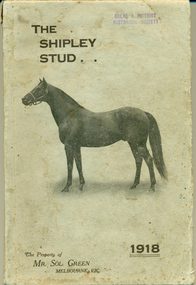 Warrnambool and District Historical Society Inc.
Booklet, The Shipley Stud 1918, 1918
Sol Green came to Australia as a penniless migrant who made his fortune as a bookmaker. He was inducted into the Australian Racing Museum Hall of fame in 2002. He purchased the Shipley stud from George Rolfe about 1905 and set about turning the Ayrford cattle property into a successful horse stud. His horse Comedy King won the Melbourne Cup in 1910 and was retired to stud in 1912. He became one of the top 10 Australian Stallions in the ensuing years. He dispersed his stud at Shipley in 1918 and this catalogue lists the stock sold that day. The property remained in the Green family and continued as a dairy farm with cheese factory and piggery by his son Bob Green. Sol Green was known for his philanthropic gestures extending help where needed on various fronts. Shortly before his death in 1948 he donated 47000 pounds to five Melbourne hospitals.This catalogue has significance firstly on a local level in that Shipley was an important farm in the district and secondly that it was owned by Mr Sol Green who was a person of standing within the racing industry as a bookmaker but also as a stud owner and owner of a Melbourne cup winner in 1910. This catalogue lists the stock which he had established at Shipley in a relatively short period of time.Light grey card cover with horse in brown. The title is in top left corner in brown text with the date 1918 in bottom right. Compilers details on back cover. 164 Pages. It has black and white plates of two horses, Comedy King and White Star* Mallinson Pomborneit 9/1/18. Light paper pasted inside front cover “Colac and District Historical Society, Donor Miss Betty Mallinson 1960. There are purchasers’ names and the purchase price paid, written at the base of each page. warrnambool, allansford, shipley, sol green, comedy king, white star 1918, shipley dispersal sale, shipley stud -
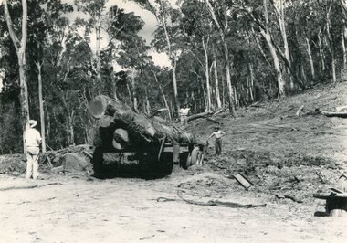 Kiewa Valley Historical Society
Photo - Mountain Creek Logging Camp, 1955
Hume and Hovell discovered the area in 1824 and by the end of the 19th century the valley was transformed by logging, dairy and beef cattle properties and tobacco farms. The logs could have been milled for timber at the State Electricity Commission's mill at Howman's Gap which provided a much needed source of timber for construction of McKay Creek Power Station which began construction in 1951 and also the camps and houses for the workers and their families. There was a need for housing and infrastructure for an increasing population of workers for the hydro-electric scheme as there was a general shortage of this commodity. A timber mill was started in Tawonga by Mates, of Albury, in 1945, and electricity became available in 1946 the S.E.C. bought the mill, and enlarged it. In 1960 it was purchase by a local family, they also started a timber mill in Mt Beauty worked both until 1980 when they closed it. The Tawonga mill and enlarged the mill called Mt. Beauty Timbers Pty Ltd employed approximately 50 people. An historical pictorial record of the general working conditions, type of machinery and vehicles in use in the 1950’s. Note the lack of protective clothing!Black and white photograph of the logging camp at Mountain Creek. November 1955Handwritten on the back of photograph - MOUNTAIN CREEK LOGGING CAMP NOV 55mountain creek logging camp, timber industry, tawonga