Showing 2764 items
matching r blacker
-
 Greensborough Historical Society
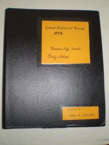
Folder, Watsonia High School - Historical Records 1984 - Volume Two, 1984_
... staff notices student notices Compiled by Maria R. Wozniac Black ...Created in 1984 by a member of the Watsonia High School staff (Maria Wozniac) as a permanent record for future safe keeping - 27 years on it has found the perfect permanent home at Greensborough Historical SocietyReflects through documentation of that time, how a Victorian Secondary School functioned during the 1980's. A good comparator for readers of George Orwell's prophecy book "1984" written in 1948.Black 2-ring binder, foolscap size, Contains: Daily Notices. These notices appeared on the Staffroom Noticeboard and next to Student Timetables. Compiled by Maria R. Wozniacwatsonia high school, staff notices, student notices -
 Ararat & District Historical Society (operating the Langi Morgala Museum)
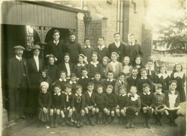
Photograph, 1920s
This appears to be a photo of all or most of the Pupils and Staff of Ararat Church of England School, ca1920s. The names of all or most are written on the back of the photo.This is an early photo of the Ararat Church of England School. The date, and the names attached to or written on the back of the photo add to the signficance of the photo, making it of local significance.Black and white photograph mounted on cardboard. The photograph shows a group of 39 students in four rows and a man and woman standing to their left. They are in front of a brick building.Inscription: on back, both written in ink, and repeated on an affixed cardboard label. Church of England Grammar School 1920's./ Back row left to right L. Wright, H. Banfield, T. Butt, N. Gamson, R. Hodgetts,/ T. Webb, Mr T. C. Cochrane, Miss K. Webb, First row M. Webb, L. Robertson,/ J. McKay, T. Brown, E. Brown, B. Edwards, D. Hayman, I. Edwards/ Second Row - G. Foster, J.H. Webb, B. Hayman, E. Noltenius, Temple/ B. Richardson, I. Gibletr/ Front Row: F. Ramage, W. Owen, J. Dunn, J. Foster/ M. Hayman, L. Ford, B. Nolteniuseducation, 1920, school, teacher, church-of-england, pupil, ararat-church-of-england-school, ararat-school, ararat-education -
 Eltham District Historical Society Inc
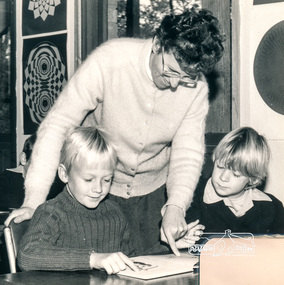
Photograph, Helen Hillas in C/R with David and Matthew Niejalke on furlough from Darwin, August, Eltham Christian School, 1983, 1983
Helen Hillas in the classroom with David and Matthew Niejalke on furlough from Darwin, August, Eltham Christian School, 1983 The Stokes family settled in this area of Eltham in the 1940s and were associated with the Eltham Christian Church. In the 1970s this church had met in temporary premises in Eltham. Lots of the original 1920s subdivision remained south of Nyora Road and a number of these lots were utilized for the Eltham Christian School, which was established by the Eltham Christian Church in 1981. The school operated on this site until 2000. The premises were owned by the Nillumbik Community Church who were in operation till November 2010 when the Eltham Baptist Church commenced a lease arrangement until the site was purchased by them in April 2012. The building is constructed of brick and timber with a balcony on two sides that looks over an expanse of grass. Sources: STOKES ORCHARD – AN INCOMPLETE HISTORY February 28, 2015 http://www.elthamhistory.org.au/ Australian Christian Church Histories - Eltham Baptist Church http://www.churchhistories.net.au/church-catalog/eltham-vic-baptist/ From a magnetic spiral bound photo album featuring a series of photographs (some cropped) with captions relating to the staff, students and activities of the Eltham Christian School which operated as part of the Eltham Christian Church at Nyora Road, Eltham. See also entries for each photograph.Black and white photographeltham christian school, nyora road, helen hillas, david niejalke, matthew niejalke -
 Kiewa Valley Historical Society
Photograph Farm Land, Mount Beauty Acreage before Golf Course, Circa 1950
This photograph is a "snap shot" in time circa 1950s detailing the rural environment before the effects of the Kiewa Valley Hydro Scheme altered the basic rural setting of the valley. The golfing fairway was being mapped out on previous grazing land, before the laying of a golf course, for use by the construction workers and auxiliary administration employees of the Victorian State Electricity Commission. This photograph details a dramatic period in time which saw an enormous change to the exclusively rural area of the Kiewa Valley region in the mid 1900s. This change presented both physical and mental challenges to the existing quiet rural inhabitants of the valley. The State of Victoria had to make adjustments to the changing demands imposed by population and industrial expansions. The development of cleaner energy supplies to a growing population has its downside ,which ever way the intrusion into the "natural" landscape is made.Black and white photograph detailing surveyor posts for construction of golf course. Land used, before establishment of the Mount Beauty Village, as farming/grazing cattle and viewed towards Mount Bogong and its Alpine ranges. The photo is on 200gms paper and not on photographic paper.nilmount beauty in the 1940s - 1950s, grazing in the kiewa valley, sec victoria -
 Kiewa Valley Historical Society
Photograph Transmission lines Mount Beauty, 66 KVA Transmission lines from Clover Power Station, Circa 1950
This photograph is a "snap shot" in time circa 1950s detailing the rural environmental change and the progressive effects of the Kiewa Valley Hydro Scheme on the basic rural setting of the valley (note the sparsity of rural infrastructure). This photograph shows the beginning of the accommodation and administration buildings for use by the construction workers and auxiliary administration employees of the Victorian State Electricity Commission. It also provides a view of the landscape before extensive development of Pondage and other non rural buildings.This photograph details a dramatic period in time which saw an enormous change to the exclusively rural area of the Kiewa Valley region in the mid 1900s (see sparse rural buildings/houses). This change presented both physical and mental challenges to the existing quiet rural inhabitants of the valley. The State of Victoria had to make adjustments to the changing demands imposed by population and industrial expansions. The development of cleaner energy supplies to a growing population has its downside ,which ever way the intrusion into the "natural" landscape is made. The construction of the large Pondage at the centre of the photograph is a good example.This black and white photograph of a panoramic view of the Kiewa Valley (Mount Beauty SEC construction workers village) shows the newly completed transmission line towers delivering electrical power(66KVA) from the Clover Power Station. The photo is on 200gms paper and not on special photographic paper.mount beauty 1940 to 1950s, development of sec kiewa hydro scheme, sec victoria -
 Kiewa Valley Historical Society
Photograph from Lake Guy, Bogong Village, Scene from shores of Lake Guy to Mountain range, 1930s to 1950s
In 1940 Field Headquarters for the Kiewa Scheme were established at Bogong with office, workshop facilities and accommodation for workmen, staff and some families constructed. (There had been a 'tent camp' on this site in 1939 but was destroyed by bushfires) Construction of accommodation continued until 1947. A total of 40 houses plus a hostel for single staff, post office, police station, medical centre and primary school all with water and sewerage and electricity supply. The staff hostel was known as Kiewa House and is now occupied by the Education Department. Lake Guy was named after Mr. L.T. Guy who was the Resident Engineer in charge of construction work and associated activities on the Kiewa area. He held this position from 1939 to November 1946 when he was transferred to Head Office.The Bogong Township was developed firstly as an accommodation centre (base camp) for construction workers employed under the Kiewa Hydroelectric Scheme. Due to the influx of European workers into the Township the beautification of the immediate surrounds(gardens etc.) had a distinct European flavour. This environment has been very beneficial for tourism in later years. Strict environmental control has not allowed for any extensive redevelopment in tourist accommodation and basically restricted it to the accommodation initially built for the construction workers. Activities such a bike riding, snow skiing, restricted horse riding and bush walking on the Alpine plains and mountains are now a viable part of the Kiewa Valley Tourist Industry. The lake is one of the many water storage storage reservoirs used to supply the power stations their main power to run the huge turbines generating the final product, electricityThis black and white photograph shot from the shores of Lake Guy toward the mountain range of the Victorian Alps details the early construction of the construction worker's accommodation of the Bogong Village. The paper is of 200gms and is not photographic paper and can be assumed to be a reproduction of an original photobogong village circa 1930 to 1950, kiewa hydro-electricity scheme, victorian alpine region mid 1900s -
 Kiewa Valley Historical Society
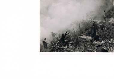
Photograph Fire Prevention Victorian Alps, Burning, Circa 1950
This photograph, in late 1950s, shows an Alpine Fire Prevention technique of "burning off" low levels of scrub to reduce the level of available fuel against any possible summer bush fires. The Alpine regions accumulate high levels of potential fuel (undergrowth and small shrubs) which if not reduced has the potential of breaking into a dangerous bush fire. The men in this photograph are not wearing any protective clothing. Their visibility to other firefighters is severely reduced by smoke. This photo is a snap shot in time when Occupational Health and Safety Legislation was in its infancy stage.This photograph details the fire prevention activities in the Victorian Alps under the management of the SEC Victoria. The level of undergrowth within the Australian bush needs to be kept under control to avoid the possibility of lightning strikes (during summer storms) igniting dry forests resulting in a major bush fire. Controlled fires within alpine regions are required not only to reduce the level of dry undergrowth but also to provide those various plant species requiring fire for regenerate. This method was used by the original inhabitants (Aborigines) as limited scrub fires were used to flush game and bird population for eating with the side benefit to those plants requiring the fire for regeneration.This black and white photograph shows an Alpine Fire Prevention technique of "burning off" low levels of scrub. The photograph is on 200gsm paper but it is not photographic paper. It can be assumed that the photo is not the original but a copy. alpine fire prevention, sec fire prevention -
 Kiewa Valley Historical Society
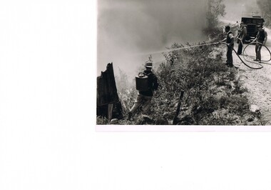
Photograph Fire Prevention Victorian Alps, Burning, Circa 1950
This photograph, from the 1950s, shows an Alpine Fire Prevention technique of "burning off" low levels of scrub to reduce the level of available fuel against any possible summer bush fires.The Alpine regions accumulate high levels of potential fuel (undergrowth and small shrubs) which if not reduced has the potential of breaking into a dangerous bush fire. The men in this photograph are not wearing any protective clothing. Their visibility to other firefighters is severely reduced by smoke. This photo is a snap shot in time when Occupational Health and Safety Legislation was in its infancy stage.This photograph details the fire prevention activities in the Victorian Alps under the management of the SEC Victoria. The level of undergrowth within the Australian bush needs to be under control to avoid the possibility of lightning strikes (during summer storms) igniting dry forests resulting in a major bush fire. Controlled fires within alpine regions are required not only to reduce the level of dry undergrowth but also to provide those various plant species requiring fire for regenerate. This method was used by the original inhabitants (Aborigines) as limited scrub fires were used to flush game and bird population for eating with the side benefit to those plants requiring that fire for regeneration.This black and white photograph shows an Alpine Fire Prevention technique of "burning off" low levels of scrub. The photograph is on 200gsm paper but it is not photographic paper. It can be assumed that the photo is not the original but a copy produced by the SEC Vic. See also KVHS 0413 and KVHS 0414 for other similar photos.kiewa valley tourism, victorian alps, alternate energy supplies, alpine population growth -
 Kiewa Valley Historical Society
Photograph Fire Prevention Victorian Alps, Burning, Circa 1950
This photograph, in late 1950s, shows an Alpine Fire Prevention technique of "burning off" low levels of scrub to reduce the level of available fuel against any possible summer bush fires. The Alpine regions accumulate high levels of potential fuel (undergrowth and small shrubs) which if not reduced has the potential of breaking into a dangerous bush fire. The men in this photograph are not wearing any protective clothing. Their visibility to other firefighters is severely reduced by smoke. This photo is a snap shot in time when Occupational Health and Safety Legislation was in its infancy stage.This photograph details the fire prevention activities in the Victorian Alps under the management of the SEC Victoria. The level of undergrowth within the Australian bush needs to be kept under control to avoid the possibility of lightning strikes (during summer storms) igniting dry forests resulting in a major bush fire. Controlled fires within alpine regions are required not only to reduce the level of dry undergrowth but also to provide those various plant species requiring fire for regenerate. This method was used by the original inhabitants (Aborigines) as limited scrub fires were used to flush game and bird population for food, with a side benefit to those plants requiring the fire for regeneration.This black and white photograph shows an Alpine Fire Prevention technique of "burning off" low levels of scrub. The photograph is on 200gsm paper but it is not photographic paper. It can be assumed that the photo is not the original but a copy. See also KVHS 0413 and KVHS 0415 for other similar photos.kiewa valley tourism, victorian alps, alternate energy supplies, alpine population growth -
 Kiewa Valley Historical Society
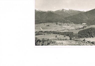
Photograph of Kiewa Valley Panorama, Farming lands within the Kiewa Valley in1950s, Circa 1950
This photograph shows how (early to mid1900s), before the establishment of the Mount Beauty "gated" village, the Kiewa Valley was farmed and the scarce population was spread out over acres of productive land. This photograph catches a time before (what appeared to the local farmers as the invasion by a mass of construction workers) when this remote valley was part of a "lay back" rural landscape,occasionally visited by friends and some wayward tourists. The mountain ranges provided an adequate barrier against the way-would traveller. The immigration numbers coming into Australia was still quite small ( due to the "white" Australia policy) which was in force before World War II. After World War II a mass of displaced European refugees and migrants boosted the Australian population and provided for a greater degree of diverse professions and rural related work force.This photograph depicts the borderline in time between an exclusively rural based population and respective activities(early 1900s)to the present (2000 on wards) integrated village, tourist and retiree/holiday area. The time when land was exclusively used in agriculture is over and the impact of cheaper rural produce from Asian markets will see a shift of land useage and population activities. The Kiewa Valley is loosing its hiding place and is becoming more and more a source of untapped residential land. Black and white photograph of farming/grazing land useage, before the establishment of the Mount Beauty Village. Small pockets of residentual houses can be viewed. Road access (unsealed dirt) was typical of that provided in rural regions in the 1950s. The photo is on 200gms paper and not on photographic paper.kiewa valley in the early1900s, grazing in the kiewa valley, sec victoria -
 Kiewa Valley Historical Society
Photograph of Snow Covered Catchment Area Vic, Snow Covered Catchment Area Victorian Alps - 1950s, Circa 1950
This photograph details (early to mid1950s), the Victorian Alpine region when this remote area was part of a "lay back" rural landscape,occasionally visited by recreational adventurers and some wayward tourists. The mountain ranges had provided an adequate barrier against the way-would traveller, but with the opening up of this region by the provision of improved roadways and accommodation facilities, courtesy of the Kiewa Valley Hydro Electricity Scheme, changes such as tourism and its impact upon the "natural" state started to show its side effects (clearing of the land). The expansion of the European immigration numbers (1950s) coming into Australia was increasing after World War II which not only provided increased construction workers to the region but also immigrants who appreciated alpine regions. Some of these immigrants contributed to the expansion of the region and provided for a greater degree of diverse professions and rural related work force.This photograph depicts the borderline in time between an exclusively rural based population and respective activities(early 1900s)to the present (2000 on wards) integrated village, tourist and retiree/holiday area. The time when land was exclusively used in agriculture and Alpine grazing lands is over. The Kiewa Valley is loosing its hiding place and is becoming more and more a source of untapped residential land and winter time recreational adventure lands. The changes brought about by modern technologies involving recreational activities such as hang gliding, gliding (local airstrip), mountain bikes, car rallies and their associated clubs is providing for an increased short term population boost. These together with the attractions for retirees is changing not only the physical nature of the Kiewa valley but also its "soul".This item is a black and white photograph of a section of snow covered catchment area in the Victorian Alps in the mid 1900. It is on 200 gms paper but not on photographic paper and has a white boarder (3 mm).kiewa valley tourism, victorian alps, alternate energy supplies, alpine population growth -
 Eltham District Historical Society Inc
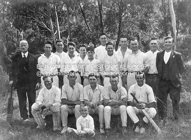
Photograph, Glen Park Cricket Club, c.1928, c.1928
Notes provided by researcher, Alan Sheehan. Photo dated about 1928 or could be earlier. Back Row (standing) L to R: Mr Le Brocq (in suit with bat), George Colman, Jack Colman, Bill Bonks, Alan Bunker, Henry Downing, Mick Le Brocq, Laurie Crisp, George Le Brocq, - , - , -; Front Row (seated) L to R: Bill Noble, - Downing, - , - Cunningham, - ; Boy in front: Ron Le Brocq. Note: George and Mick Le Brocq were brothers and sons of Mr Le Brocq in photo. Ron Le Brocq was another brother or possibly the son of Mick Le Brocq. George Le Brocq did not have any children.Black and white print mounted on embossed cardOn reverse - Glen Park Cricket Team c. 19281928, alan bunker, bill bonks, bill noble, cunningham, downing, george colman, george le brocq, glen park cricket club, henry downing, jack colman, laurie crisp, mick le brocq, mr le brocq, ron le brocq -
 Eltham District Historical Society Inc
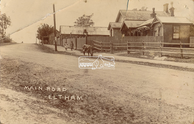
Photograph, J.H. Clark (poss), Main Road, Eltham, c.1910
Original photo from a scrapbook belonging to Heather Jenkins (nee Cone) who lived as a child in the Police Residence at 728 Main Road, Eltham from 1911 to the early 1920s. (Reported in Newsletter No. 98, Sept., 1994). View looking north up Policeman’s Hill across Main Road towards the Police Station, Police Residence and Courthouse, c.1910 prior to Brougham Street being made. The two rails / gap in the fence would be where Brougham Street now enters Main Road. Also visible are Knapman's Forge adjacent to Courthouse and E.J. Andrew's Store on top of the hill At the upper left can be seen the front of the Evelyn Hotel. On the opposite corner was Watsons Hotel. E.J. Andrew's store with its verandah was on the corner of Franklin Street. Behind the picket fence stands the 1860 Court House and Police residence with the weatherboard clad Police office. The enclosed fence is now the end of Brougham Street, opened to Bible Street in 1926. The Evelyn Hotel (formerly Fountain of Friendship) burnt down in the 1930s when it was being used as a boarding house since 1919. A cow is feeding on the grass verge in street. The photo is identified in white lettering typical of the style of Clark Bros., photographers of Windsor, Melbourne (1894-1914). One of the brothers, John Henry Clark, took many early photos around Little Eltham and moved to Eltham in 1916 where he lived at the bottom of the hill. Typically, he would add “J.H. Clark Photo” to his personal work, but this is not evident. There is however some ghost writing, a cheeky inscription in small white lettering in the grass verge in front of where Brougham Street is, which appears to state: “Heather or Hannah was here”. Perhaps J.H. Clark took the photo during a trip to Eltham and gifted it some years later after moving there as a gift to a young Heather Cone. The Police Station sign: E vii R ELTHAM POLICE STATION HEIDELBERG DISTRICT Edward VII ascended the throne in 1901 and died 6 May 1910. He was succeeded by George V.Heather Cone was the daughter of Constable John Thomas Cone (Badge 3935) the local police officer in residence at Eltham, 1 May 1911 to 9 July 1922. Heather McKnight Jenkins (nee Cone) was born 1911, possibly at the Eltham Police Residence and spent her childhood growing up in the Police Residence. Heather was the daughter of John Thomas Cone, Police Constable, and Charlotte Helena Cone (nee Black) who had married in 1906. Constable Cone was transferred to Eltham Police Station from Lauriston (near Kyneton) in May 1911. He retired from the force around September 1922 most likely as a result of significant health concerns experienced earlier that year from 22 April when he was hospitalised. He died 5 October 1922 at Maria Street at age 60 leaving behind a widow and two daughters; his son having pre-deceased him as a result of effects of the war. He is buried in Melbourne General Cemetery . In his probate it states that he owned a piece of land 200 links frontage to Maria Street and a depth of 241 links. It is believed that this is the land opposite the Police Station which Heather Jenkins referred to as being owned by her father and where he agisted the Police horses. Heather, her sister and mother Charlotte remained in Eltham until at least the 1924 Electoral Roll where Charlotte was listed as Home Duties however by 1925 she was listed at 229 Glenferrie Road, Malvern, occupation, Registrar of Births. In the 1934 (and 1936) Electoral Roll, Heather was a Clerk and her mother Charlotte was the Registrar of Births. in 1952 following her mother’s death she made application for Grant of Probate. Heather remains listed in the 1954 Electoral Roll at 13 Ashburton Road under her maiden name Cone however by the 1963 Electoral Roll she is listed at the same address as Heather McKnight Jenkins long with James Gardiner Jenkins. Neither appear listed in the 1958 Electoral Roll. James Gardiner Jenkins (1892-1975) first wife was Fanny Davison Carrucan (1899-1929), daughter of Denis Carrucan and Jane (nee McAleese). They married in 1925. Fanny died 11 November 1929. In the 1934 Electoral Roll he remained listed at John Street, Eltham, Railway Employee however by 1935 Electoral Roll, James Gardiner Jenkins, Railway Employee, was listed at 229 Glenferrie Road, Malvern and he remained living with Charlotte and Heather Cone when they moved to 13 Ashburton Road, Glen Iris. One of Constable Cone’s first investigations upon arriving in Eltham was the accidental fatal shooting in the head with a pea rifle by young Francis August Capewell, aged 11, of John Sutcliffe Deegan, 14, in Maria Street near the Railway. Constable Cone’s replacement was Constable William Charles Sargeant who commenced in charge of the Eltham Police Station from Thursday, 10 August 1922. Constable William Charles Sargeant, and his wife Elizabeth Agnes Sargeant were based at the Eltham Police Station until his transfer to the Police Station in Burwood Road, Hawthorn. He retired at Hawthorn Police Station in 1931, described by Hawthorn Council in 1927 as in a disgraceful condition and unfit for human habitation (Kathryn Griffin family tree – Ancestry) whereupon they moved to 28 Saunders Street, Coburg. Elizabeth died 16 July 1936 in Fitzroy. William then moved to 6 Queen Street Coburg in 1936 and then 1 Queen Street in 1942 where he died 7 August 1944. He is buried at Fawkner Cemetery.Sepia postcard photo glued on a brown paper scrapbook page (torn from scrapbook) along with 8 other black and white/sepia photos of varying sizes, 1 newspaper clipping and handwritten captions in ink.brougham street, constable w.c. sargeant, courthouse, cow, eltham, knapmans forge, little eltham, local history centre, main road, maria street, police residence, police station, policeman's hill, scrapbook, w.b. andrew corn store, j.h. clark photo, andrews store, heather jenkins (nee cone), clark bros. photo -
 Eltham District Historical Society Inc
Photograph, Looking north from Staff's Railway Store overlooking garden and foundations of Lyon's Garage
L-R: Eric Staff, Michael Sinclair, Marie (Mary) Staff, Mrs Rigby, Eileen Rigby, Mr Rigby (partly hidden); Michael Sinclaiur in foreground. On back of photo: "I had this taken to show you Lyon's Garage. You can see the foundations and the filling in. Like our lawn. The Xmas tree we had for Michael with X" Black and white photographeltham, main road, lyon's garage, michael sinclair, eric staff, marie (mary) staff, mrs rigby, mr rigby, eileen rigby -
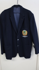 Kiewa Valley Historical Society
Blazer - Bowls -Mt Beauty Working Man's Club
... bowling club r. burnett bowling blazer Black wool blazer fully ...Mt Beauty Workman's Club was formed in 1945, re-built and opened in 1954 and again in 1962 and 1968. The Bowls club was founded in 1970 and later was affiliated with the Victorian Ladies' Bowling Association (VLBA) and the North Eastern District LBA in 1974. There were strict rules regarding the Bowlers' uniform.The Mt Beauty Workman's Club was built by the SECV in 1945 to service their employees on the Kiewa Hydro Electric Scheme. As Mt Beauty grew it became the centre of activity for residents including the Bowling Club. The blazer is an example of the dress code for men playing bowls at the time.Black wool blazer fully lined with long sleeves, collar, 2 silver buttons. 3 pockets on the front - 2 on the bottom - left and right - and one at the top on the left. This one has a woven green, yellow and white logo with RVBA at the top and 'Mt Beauty Workman's Club' underneath. There is an inside pocket on the top right side with a label 'Blazer and Uniform Specialists / David Lack / Pty Ltd / Melbourne / Name "R. Burnett" / No. "3888"' - the name and number are typed in.mt beauty workman's club, mt beauty bowling club, r. burnett, bowling blazer -
 Kiewa Valley Historical Society
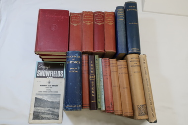
Books - Ron White Collection
Ron White was b. 1920. he received a Diploma of Mechanical Engineering at Footscray Technical School in 1946. He worked for the SECV from 1948 until 1985. In 1961 he was officially recognised as deputy for the General Superintendent, Kiewa. He was 'Principal Hydro Engineer, Hydro Division, Transmissions Operations Deparment - a position held until his retirement in 1985. Ron White studied engineering at Footscray Technical School. His books are part of his collection as he was principal Hydro Engineer from 1966 to 1985 with the SECV on the Kiewa Hydro Electric Scheme. He had a close association with the local communities and care for the welfare of employees. He lived at Mt Beauty and passed away on 30th September 2019, aged 99 years.1. x7 Charles Dickens novels. All red hard cover and bound with 764 pages. Gold embossed title & author on spine. 2. x2 English Books used at Footscray Technical School. Green hard cover with black title and print and Blue cardboard cover with black title and print. 3. x8 Science and Maths Books used at Footscray Technical School. All hard cover text booksAll with 'R. White' written on cover pageron white, secv engineer, charles dickens, footscray technical school, khes -
 Kiewa Valley Historical Society
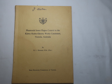
Book - Phasmatid Insect Plague Control in the Kiewa Hydro-Electric Works Catchment, Victoria, Australia. 1964, by R. L. Newman, B.Sc. (For.), Works Forestry Officer - Kiewa Territory
The Phasmatid Didymuria Violescens have been increasing and causing defoliation in south eastern Australia.The author R.L.Newman is the 'Works Forestry Officer - Kiewa Territory reported for the SECV'Fears have been held for the survival of stands of certain eucalypt species the destruction of which might have affected the stability of the Kiewa catchment. Spraying was carried out by the SECV in 1961 and 1963. This was found to be successful indicating that there will be no need for further spraying in the treated areas at least for some years.'Yellow book with 74 pages. Cover has the SECV emblem at the top centre. Print with black and white pictures / illustrations.In Pen - J. Watson on the cover.phasmatid insect plague, r.l.newman, forestry officer kiewa territory -
 Kiewa Valley Historical Society
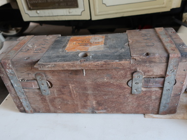
Cartridge Box - B.L.Martin-Henry Arm
A box used to store and carry cartridges safely. It is protcted from moisture entering. Labelled with caliber, quantity and manufacturing date or lot number. The Martini-Henry is a single shot ricle with a lever action used in WWI.Sturdy rectangular wooden box with steel straps. At the top is a sliding opening with yellowish wood and printed black label."680 / Cartridges / Ball / b. L. Martini-Henry Arm / Mark V / R. L. " is printed in black on uellowish wood at the top centre of the box. More printing on the top each side "C & H' and "C?? / 19,2,75?"ammunition box, cartridge box, dederang rifle club -
 4th/19th Prince of Wales's Light Horse Regiment Unit History Room
Photograph/Postcard, Pte Robinson, 1916
A black & white postcard photograph of Pte R Robinson. He is in AIF uniform and wearing a peaked capOn back: "Pte R Robinson Sailed 2-10-16" and "Mr A Daniel"photo, pte robinson -
 Kiewa Valley Historical Society
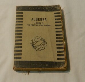
Book - Reference Maths, R. Wilson & A.D. Rose, Algebra A Sequel To
R. Wilson and A D Rose maths books were very popular and formed a basis of education maths classes in the 1950's in Victoria. This is what would have been used in Mt Beauty Secondary School at the time.This has historic significance as it shows what maths was taught in the early - mid 20th century. This book would have been used in the Kiewa Valley schools by a local identity Wilma Davies therefore has social significance and good interpretive capacity. This book is now out of print and is a collectible item. Black cover with strips on side of the front. Light brown centre with brown writing and squiggle pattern below.Publisher inscription - Wilson and Rossbook, school, text book, wilma davies, educational, maths -
 Kiewa Valley Historical Society
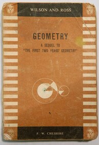
Book - Maths, R. Wilson & A.D. Rose, Geometry A Sequel To, 1950 onwards
This book follows on from the revised edition of "First Two Years Geometry" and contains all the geometry for the intermediate certificate and trigonmetry included in the syllabus during the mid 20th century. This would have been used by students of the Kiewa Valley.This book show us the type of maths that was taught in Victorian schools in the mid 20th century. Students from Mt Beauty Elementary High School would have used this book. Therfore has historical and research significance. The book has the name G Davies, which is a local family and therefore has social significance. As this is part of our school book collection it has good interptive capacityThe book has a brown cover with light brown striped pattern along the edge of the front cover. Black writing on front for name and light brown writing stating author and publisher. Has a light brown gemonetry pattern on front cover and logo of printer on each corner.Name of G Davies Form 111 in red pen on inside page.book, school, geometry, educational, math, mt-beauty-elementary, wilma davies -
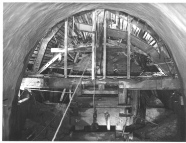
 Kiewa Valley Historical Society
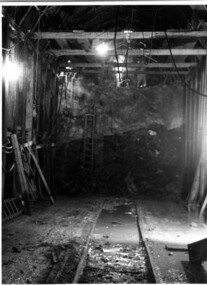
Photograph Tailrace tunnel Arch Drive, Tunnel face at Tailrace showing Arch Drive, between 1943 and 1952
This photo was taking during construction of the tailrace tunnel between West Kiewa Power Station and Mt. Beauty. Much of the area was unstable and timber supports were erected prior to concreting. The tunnel was commenced in 1941 and completed in 1952. It brings water from the power station into the open tailrace at Mt. Beauty and then into the regulating pondage before discharge into the Kiewa River.Shows method of construction for supporting walls and ceiling of tunnel with timber, size of tunnel (note worker on upper level), and conditions in the work place during construction in the 1940's/50's - note the timber ladder to gain access to the upper level.Black and white photographHand written on back of photograph "Tunnel face at Tailrace showing Arch Drive".tailrace, power station, water, construction -
 Kiewa Valley Historical Society
Photograph of Lake Guy and Bogong Village, Lake Guy and Bogong Village, Approx. 1945
In 1940 Field Headquarters for the Kiewa Scheme were established at Bogong with office, workshop facilities and accommodation for workmen, staff and some families constructed. (There had been a 'tent camp' on this site in 1939 but was destroyed by bushfires) Construction of accommodation continued until 1947. A total of 40 houses plus a hostel for single staff, post office, police station, medical centre and primary school all with water and sewerage and electricity supply. The staff hostel was known as Kiewa House and is now occupied by the Education Department. Lake Guy was named after Mr. L.T. Guy who was the Resident Engineer in charge of construction work and associated activities on the Kiewa area. He held this position from 1939 to November 1946 when he was transferred to Head Office.This photograph is an excellent historical record of Bogong Village in about 1945. It shows the layout of the town in the fairly steep terrain, the workmen's camp between the houses and the lake foreshore, the Commissioner's Lodge on the hill behind the Village, the walkway through the dam wall can be seen to the left of the spillway, the dam is on spill and note damage to the large trees is still evident from the 1939 bush fires. The Commissioner's Lodge was lost in the 2003 fires and the camp buildings were in service until 1962, when they were removed and the site converted into a public picnic area with lawns and gardens.A Black and white photograph"Lake Guy and Bogong" hand written on back of photograph.kiewa, accommodation, lake, dam, bogong -
 Kiewa Valley Historical Society
Photograph during construction of West Kiewa tunnel, 'Timbering in West Kiewa Tunnel', c1947
The West Kiewa Tunnel (tailrace tunnel) was commenced from both ends in 1947. Very difficult conditions were encountered in the driving of this tunnel and this meant the immediate provision of support and later the lining of the tunnel with concrete. Work proceeded steadily and the breakthrough of the two headings occurred on 22nd July, 1950.This historical photograph shows in detail the amount of work necessary to stabilise and support the tunnel walls before lining with concrete. No solid rock was found and the tunneling proceeded through decomposed boulders, gravel and clay, hence the necessity for support and concreting. Black and white photograph showing the timber support, prior to lining with concrete, in the West Kiewa tunnel.Timbering in West Kiewa Tunnelwest kiewa, tailrace, tunnel -
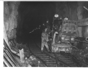 Kiewa Valley Historical Society
Photograph of Rail Mounted Battery operated soil Bucket, between 1941 and 1946
This machine was in use in the 1940's during the construction of the tunnels for the Hydro Electric scheme. This particular photograph was taken in the Tailrace Tunnel which brings water from West Kiewa Power Station to the open tailrace in Mt. Beauty and then into the regulating pondage before discharge into the Kiewa River. This machine (or one similar) is on display on the Northern side of the entrance to the Visitor's Centre. The tailrace tunnel (or West Kiewa tunnel) was commenced in 1947 from both ends and the breakthrough occurred on 22nd. July, 1950Shows the size of the tunnel and the machinery used for excavation in the 1940's/50's.Black and white photographHandwritten on back of photograph "Jumbo" in Tailrace Tunneltunnel, machinery, water, tail race -
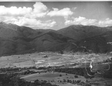
 Kiewa Valley Historical Society
Photograph of Kiewa Valley Panorama, Kiewa Valley from No. 5 Road, Before 1945
In 1943 a camp for workmen was erected and a commencement made with the erection of plant storage and workshop buildings in the new township of Mt. Beauty. The photograph was probably taken after the completion of these buildings. There is no sign of construction of the town itself. In the latter part of 1945 work was commenced on the Mt. Beauty township area with a medical centre, general trading store and some houses under construction. The No. 5 Road, from where the photograph was taken, is the road to West Kiewa Power Station and Big Hill Scenic Lookout.Is an excellent view of the Kiewa Valley before there was little work undertaken to establish the town of Mt. Beauty. Farming was well established with the evidence of huge areas of cleared land. The junction of the East and West Kiewa Rivers can be clearly seen. The first Workmen's camp is near the river and some workshop buildings can also be seen. Black and white photograph of the Kiewa Valley, looking North.Handwritten on the back of photograph "Kiewa Valley from No. 5 Road".kiewa valley, camp, buildings, mt. beauty -
 Kiewa Valley Historical Society
Photograph of Mt. Beauty, Mt. Beauty from transmission line, Approx 1950/51
This photo is of the very newly constructed State Electricity Commission town of Mt. Beauty. The houses up to Nelse street were erected from 1946 onward and then the township was extended beyond Nelse Street in 1950 which places this photograph about 1950/51. There is no evidence of work being commenced on the regulating pondage but the tail race canal can be seen on the centre right of photo. The workmen's camp was enlarged in 1950 to the extent of providing accommodation for a total of 1,200. There are a number of dwellings on Simmonds Creek and the road to Falls Creek can clearly be seen. Snow capped Mt. Bogong is in the upper left of the photo with Mt. Beauty behind the township rising to Big Hill beyond that.Shows the newly constructed town of Mt. Beauty surrounded by farmland and before the regulating pondage was built to discharge water from the power stations via the West Kiewa tail race tunnel into the Kiewa River. Black and white photographHand written on back of photograph "Mt. Beauty from Transmission Line"mt. beauty, construction, pondage, state electricity commission -
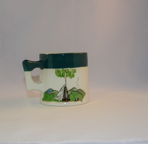 Kiewa Valley Historical Society
Mug Stoneware
This ceramic mug is titled "Bill Bogong's Mug" in honour of one of Australia's Scouting (Rovers) notable office holders, Mr.W.F."Bill" Waters. He was born on 22nd August 1897 in Taralgon, Victoria, Australia and died 8th October 1968 in Fitzroy, Victoria. He was instrumental in the Rovers building two chalets in the Victorian Alps. The Victorian Award of the National Rover Service Award(1980) has been named after Bill Waters. Bill Waters was also the leader of the first team that climbed Mount Bogong in winter in 1929. Also was part of rescue team of what is now know as the Cleve Cole tragedy on Mt Bogong in the mid 1930's. There is also a water fall named after him Waters Falls on the Bogong High Plains. W.F."Bill" Waters aka "Bill Bogong" (Bogong mountain, were his ashes were scattered), was not only a prominent bush walker (Melbourne Walking Club) of the high country (Victorian Alps) but was instrumental in establishing two Chalets. One of these Chalets was the first one to be built on the Bogong High Plains. This item, "Bill Bogong's Mug" is what the Flinders Petrie(famous English Egyptologist/Archaelogist) Rover Crew(formed in 1940) presented newly invested members of the exclusive(200 membership) Alpine Rover Crew. The Melbourne Walking Club has a long history with the Victorian High Plains area, of which the Kiewa Valley is an integral part of the Victorian Alpine Region. Due to the connections Bill Waters has with the Bogong High Plains and Mt Bogong this cup has a lot of significance to the social history of the area.. Round glazed stoneware mug, white in colour, with a heritage green coloured band covering the top rim and handle. Written inscription on the front "Bill Bogong's Mug" in large print and beneath it, in smaller print, "with compliments from Flinders Petrie Rover Crew" The other side of the mug is a free hand landscaped drawing of green bush and blue hills with a tree supporting a tent and a camp fire (with smoke rising from it).To the left of the inscription is the Scout (Rover) emblem coloured black with an unraveled and unwritten signage scroll fowler ceramics, local alpine history, alpine rovers, scouts, mugs, mt bogong, bogong high plains -
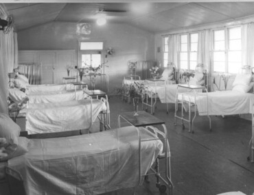 Kiewa Valley Historical Society
Photograph Tawonga Hospital, A ward at Tawonga Hospital, 1949/50
This photo is of a ward - probably the female ward, as there a many floral arrangements - of the original hospital at Tawonga. This was situated at the corner of Ryders Lane and Kiewa Valley Highway. The building was transported from Bonegilla where it was originally a part of the Bonegilla Military Hospital. The hospital was opened on 24th September, 1949 with a capacity of 12 beds, but was later increased to 35 beds by enclosing the verandahs on 3 sides of the building. 'Add ons' provided theatre, offices, stores and a nurses home. Construction was commenced by the Hospital and Charities Commission with considerable input from the S.E.C., providing the removal and re-erection of the building, the accommodation for nursing staff and carried all work necessary to make the building operational as a hospital. Up until this time the nearest hospital was at Yackandandah. The hospital remained on this site until 1961 when a larger, more suitable building was purchased in Mt. Beauty from the S.E.C.A photographic record of a typical open plan style ward in that era. There were no private rooms. There are portable screens stored at the end of the room to provide "privacy" at the bedside when needed. There is a fan on the wall for cooling. Depicts the rather primitive conditions of that era when compared with todays standards.Black and white photograph of a ward in the Tawonga District Hospitalhospital, ward, tawonga -
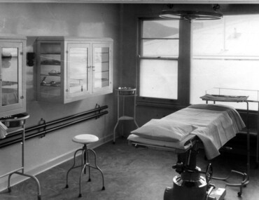 Kiewa Valley Historical Society
Photograph Tawonga District Hospital, Theatre at Tawonga District Hospital, 1949/50
The original Tawonga District Hospital was situated at the corner of Ryder's Lane and Kiewa Valley Highway. The construction was initiated by the Hospital and Charities Commission with considerable assistance from the State Electricity Commission.The building was transported from Bonegilla where it was originally a part of the Bonegilla Military Hospital. It started with 12 beds and eventually increased to a total of 35 beds. "Add ons" provided theatre, offices, stores and Nurses Home. It was officially opened on 24th September, 1949. Up until this time, any person requiring hospitalisation had to travel to Yackandandah. This photograph is of the theatre and there was no anaesthetic or recovery rooms. While rather primitive by todays standard, it met the demands of the construction days as well as that of the Kiewa Valley community. Shows the rather spartan conditions and equipment of the theatre in the original Tawonga District Hospital compared to the present day hospital. Black and white photograph of the operating theatre in the original Tawonga District Hospitalhospital, operating theatre, tawonga