Showing 1812 items
matching rivers in victoria
-
 Victoria Police Museum
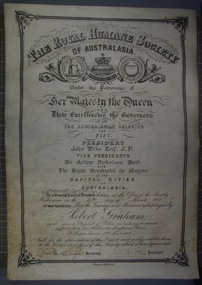
Certificate and Scroll (Robert Graham), 1888
Black embossed leather scroll with printed and handwritten Royal Humane Society Award Certificate awarded to Robert Graham for rescuing sufferers from the flood at the Goulburn River at Shepparton on 7th November 1887robert graham, greta, kelly gang, ellen kelly, royal humane society, bravery, awards, shepparton -
 Warrnambool and District Historical Society Inc.
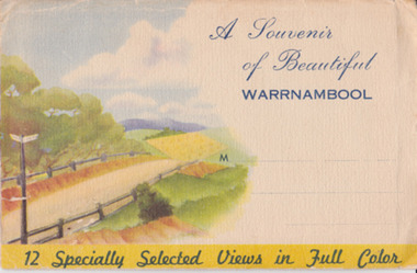
Souvenir - Post Card 12 views of Warrnambool, Nucolorvue Productions, 1950's
This type of folded postcards was popular with tourists in the 1940s, 50s, and 60s and often kept by them for many years afterwards. The views of Warrnambool here, taken about the 1950s, were typical of the Warrnambool postcards available at the time and were mass-produced as many examples survive today. They include photographs of Hopkins Falls, the beach and harbour, Liebig Street, Hopkins River, coastal scenery and the Botanical Gardens. These postcards are of some historical interest, though the photographs appear frequently in many publications. They also have a social significance showing what tourists bought 60 or more years ago.This is a packet in envelope form containing 12 coloured postcards of views of Warrnambool about the 1950s. The photographs are printed on buff-coloured paper and fold up to envelope size so that they can be sent by post. The front cover includes three dotted lines for the address and the back cover has a space to include the name of the sender. One page gives some general information on Warrnambool. Front cover: ‘A Souvenir of Beautiful Warrnambool’, ’12 Specially Selected Views in Full Color’ Back cover: ‘From…’ , ‘Published by Nucolorvue Productions, Elwood, Victoria’ tourism, warrnambool -
 Warrnambool and District Historical Society Inc.
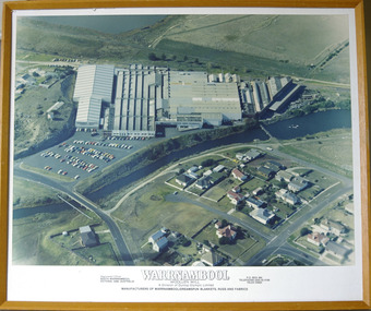
Photograph - Framed aerial photograph of Warrnambool Woollen Mill, Circa 1970
In 1869, the Warrnambool Meat Preserving Company commenced their business on the site, where it operated until 1875 when it was sold to the directors of the Warrnambool Woollen Mill Company. After being destroyed by fire in 1882 it wasn’t until 1910 that the Warrnambool Chamber of Commerce was approached by Marcus Saltau and Peter McGennan to invest in a new mill. The original directors were James Dickson, P J McGennan, Robert Swinton, M Saltau, and J W Younger. In 1955 the Warrnambool Woollen Mill formed a partnership with the Wangaratta Woollen Mills. Dunlop bought the mill in 1968. From that time until its closure in 2000 it had a number of different owners, the last being the Smith Family Industries. The Mill site holds significance for Warrnambool as the site was one of the earliest industries established in the town. The Warrnambool Woollen Mill operated for close to 100 years and in that time forged a strong link with the people of Warrnambool. Its product held a significant position in the marketplace.Aerial colour photograph of the Warrnambool Woollen Mill and surrounding area including carparks. The Merri River crosses from lower left to upper right. Playing field, Jetty Flat, in upper right hand corner and Harris Street bridge in lower left. Aspect is looking easterly. Photo glued to white card mount with text in black underneath. Timber frameWarrnambool Woollen Mill A division of Dunlop Olympic Limited. Manufacturers of Warrnambool/Dreamspun blankets, rugs and fabrics. Registered office South Warrnambool, Victoria. 3280. Australia. P.O. Box 484 Telephone (055)624166. Telex 55820warrnambool, warrnambool woollen mill, woollen mill, dunlop olympic, marcus saltau, p j mcgennan, james dickson, robert swinton, j w younger, dreamspun -
 Warrnambool and District Historical Society Inc.
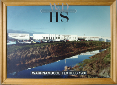
Photograph - Photograph, framed Warrnambool Woollen Mill
In 1869, the Warrnambool Meat Preserving Company commenced their business on the site, where it operated until 1875 when it was sold to the directors of the Warrnambool Woollen Mill Company. After being destroyed by fire in 1882 it wasn’t until 1910 that the Warrnambool Chamber of Commerce was approached by Marcus Saltau and Peter McGennan to invest in a new mill. The original directors were James Dickson, P J McGennan, Robert Swinton, M Saltau, and J W Younger. In 1955 the Warrnambool Woollen Mill formed a partnership with the Wangaratta Woollen Mills. Dunlop bought the mill in 1968. From that time until its closure in 2000 it had a number of different owners, the last being the Smith Family Industries. The Mill site holds significance for Warrnambool as the site was one of the earliest industries established in the town. The Warrnambool Woollen Mill operated for close to 100 years and in that time forged a strong link with the people of Warrnambool. Its product held a significant position in the marketplace.Colour photograph of the Warrnambool Woollen Mill and surrounding area including carparks. The Merri River crosses from lower left to mid right. Aspect is looking easterly. Photo glued to white card mount with text in black underneath. Timber frameWarrnambool Woollen Mill A division of Dunlop Olympic Limited. Manufacturers of Warrnambool/Dreamspun blankets, rugs and fabrics. Registered office South Warrnambool, Victoria. 3280. Australia. P.O. Box 484 Telephone (055)624166. Telex 55820 warrnambool, warrnambool woollen mill, woollen mill, dunlop olympic, marcus saltau, p j mcgennan, james dickson, robert swinton, j w younger, dreamspun -
 RSL Victoria - Anzac House Reference Library and Memorabilia Collection
Diary of William John Stephenson
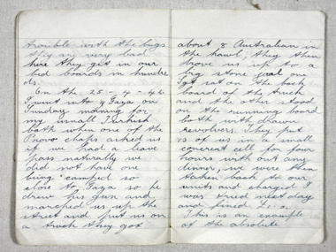
Stephenson departed Melbourne on 3 September 1941 onboard the Queen Mary. Diary runs from departure date until September 1 1942, covering Stephenson's Middle East service and his wounding in action at Alamein. One year later, Stephenson was wounded in action at Buiem River in New Guinea, and a few days later died from the wounds received.WW 2 diary of William Stephenson (VX 51713 2/23 Battalion).william john stephenson, ww11, 2/23 battalion, diaries -
 Eltham District Historical Society Inc
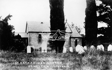
Photograph, St. Katherine's Church, St. Helena, Vic
Located at 277-279 St Helena Road Saint Helena, Victoria. In 1841 Anthony Beale, born on the Island if St Helena took a pastoral lease on the Plenty River where he built a cottage, St Helena, which ultimately gave this area its name. Beale's wife Katherine Rose, nee Young died in 1856 and he erected "The rose Chapel" to her memory. After his death in 1865 the chapel was willed to the Church of England and consecrated in 1876. It was severely damaged by bushfire in 1957. It was fully restored and rededicated in November 1957. The bell calls parishoners to Sunday services is believed to a have come from the Island of St Helena. Source: Mr. A.E. Parsons, Pryor St., Eltham (Mrs. Glasgow - daughter)Statement of Significance Last updated on - October 10, 2005 St Helena's is a rare surviving example of a churchyard cemetery. It is of local historical significance because of its association with the local pioneering family, the Beales, and other notable citizens including Walter Withers and Graham Webster. The cemetery is also the oldest in the municipality, of State significance. The high level of maintenance and the rural ambience contribute to the overall significance of the site. St Katherine's Church building has been reconstructed and is of local historical interest, principally for its value in interpreting the original setting within the Cemetery. It contains stained glass windows of local historical significance, commemorating casualties of the Beale family in World War One. - Victorian Heritage Database This photo forms part of a collection of photographs gathered by the Shire of Eltham for their centenary project book,"Pioneers and Painters: 100 years of the Shire of Eltham" by Alan Marshall (1971). The collection of over 500 images is held in partnership between Eltham District Historical Society and Yarra Plenty Regional Library (Eltham Library) and is now formally known as the 'The Shire of Eltham Pioneers Photograph Collection.' It is significant in being the first community sourced collection representing the places and people of the Shire's first one hundred years.Digital image"St Katharine's Church, St Helena, Victoria"sepp, shire of eltham pioneers photograph collection, other areas, st katherine's church, st helena -
 Eltham District Historical Society Inc
Photograph, Floodwaters, Diamond Creek, Eltham, 1934
The Diamond Creek in flood near the Main Road bridge at Eltham, Victoria. The Yarra also was in flood. In early December 1934 the "Greatest flood in the history of the Yarra" occured, according to The Argus newspaper. Bridges and houses were swept away with hundreds of people left homeless across the state. The historic 1934 flood of the Diamond Creek and Yarra River set the criteria for future planning with respect to flood water rise.This photo forms part of a collection of photographs gathered by the Shire of Eltham for their centenary project book, "Pioneers and Painters: 100 years of the Shire of Eltham" by Alan Marshall (1971). The collection of over 500 images is held in partnership between Eltham District Historical Society and Yarra Plenty Regional Library (Eltham Library) and is now formally known as 'The Shire of Eltham Pioneers Photograph Collection.' It is significant in being the first community sourced collection representing the places and people of the Shire's first one hundred years.Digital image 4 x 5 inch B&W Neg (2 frames on one neg) 9 x 15.5 cm B&W printflooding, eltham, shire of eltham pioneers photograph collection, sepp, diamond creek (river), floods, 1934 flood, diamond creek -
 Eltham District Historical Society Inc
Photograph, Odyssey House Victoria, 28 Bonds Road, Lower Plenty, 6 March 1990
Odyssey House drug rehabilitation centre in Bonds Road, Lower Plenty is a distinctive landmark, especially when viewed from across the Yarra at Templestowe. It was built in the 1950’s as a seminary for the Blessed Sacrament Fathers. Because of the poor and circuitous road access, a suspension footbridge was built across the river. As well as providing easy access for the priests residents of Templestowe could attend services at the seminary. The bridge is now part of the Yarra Trails system.Colour photographlower plenty, bonds road, odyssey house -
 Orbost & District Historical Society
programs, 1961
The Snowy River Shire was a local government area in the Australian Alps region of New South Wales, Australia from 1939 until May 2016. It was named after the Snowy River that runs through it. Prior to 1936, it had been named as Dalgety Shire since establishment in 1906. This opening of the Monaro - Gippsland Road took place on 4th May 1961. There had long been a movement in Monaro for the construction of a road to connect Monaro and Gippsland, via Inglebyra and Black Mountain. The only track was for stock, made by pioneers many years ago, and it was very circuitous. It was stated at a meeting at Dalgety that the road would open up large areas for settlement for grazing, and for timber suitable for bridgé building. The road would assist stock deal ing between Monaro and Gippsland. It would also considerably shorten the distance from Victoria for tourists visiting Canberra and Kosciusko. A committee was formed to put the proposal before the Dalgety Shire Council in the 1930s.This item is a useful research tool.Four copies of a road opening program. It has black print on white. There are black / white photographs, historical details and details of the official opening.program monaro-road snowy-river-shire -
 Orbost & District Historical Society
letters, 1910
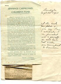
These letters were received by Henry James of Orbost. Henry James (1860-1932) was a well-known identity in the Orbost district. He was a stock agent and auctioneer who helped to establish the seed bean industry in Orbost. He was the second secretary of the Snowy River Shipping Co. as well as a shire councillor and prominent member of MUIOOF. They concern a fund established to raise money to bring the three sons of Jennings Carmichael to Australia. A committee established by Henry Gyles Turner, a a notable Australian banker and historian, was formed to raise funds to bring the boys to Australia. Grace Elizabeth Jennings Carmichael (1867-1904), poet and nurse, was born on 24 February 1867 at Ballarat, Victoria, daughter of Archibald Carmichael, a miner from Perthshire, Scotland, and his wife Margaret Jennings, née Clark, from Cornwall, England. . She was educated at Melbourne and while still a child went to live on a station at Orbost, and grew up close to the bush she came to love so much. In 1888 she went to Melbourne to be trained as a nurse at the Royal Children's Hospital, Melbourne, and in 1891 published a small volume of prose sketches, Hospital Children. Having qualified she obtained a position on a station near Geelong, and subsequently married Francis Mullis. She contributed verse to the Australasian, and in 1895 Poems by Jennings Carmichael was published. She lived for a time in South Australia and then went to London, where she died in poor circumstances in 1904. Her husband, Henry Mullis, was last recorded in the workhouse in Woolrich, but then disappeared leaving the three children- Geoffrey 7 yrs, (Thomas) Clive 5 yrs & 4 year old (Archibald) Keith and one year old (Rupert) Wyatt, destitute & were sent to the Northampton workhouse, (Thomas ) Clive dying in 1906. In 1910, a group of Carmichael's admirers, discovered the whereabouts of her children, where a public fund was established to bring the children to Australia, the Victorian Government giving them free passage, arriving in Victoria in October of 1910. The children were placed in private homes and took on their mother's single name of Carmichael. In 1910 a small selection of her poems was published, in 1937 a plaque to her memory was unveiled at Orbost in the Mechanics Institute ( reg. 554), and a year later a replica was placed in the public library at Ballarat. Two of Jennings Carmichael's sons were present at the ceremony.Jennings Carmichael, a leading Australian poet spent much of her childhood in Orbost.Several letter written to H. James concerning the Jennings Carmichael Children's Fund. Stapled to one letter is a typed article about the Jennings Carmichael Children's Fund written by Frank a. Russell. The other letter is a three page stapled handwritten letter from St Oswald's, Ormond College, seeking information about Jennings Carmichael.james-henry jennings-carmichael correspondence -
 Orbost & District Historical Society
book, Key to the System of Victorian Plants, 1887 - 1888
Ferdinand von Mueller was born at Rostock, Germany, on 30 June 1825 , died at Melbourne, Australia, on 10 October 1896. He studied pharmacy and took his Doctor of Philosophy at the University of Kiel in 1847. He came to Australia in 1848 for health reasons and became a great botanical collector and writer. He was Victorian Government Botanist from 1853, and for a time Director of the Botanic Gardens. He travelled widely in Victoria and was on the A.C.Gregory expedition to northern Australia in 1855-57. He supported botanical exploration and collecting throughout the colonies. Charles Henry [Carl] Grove died on 17/4/1938 at Box Hill at the age of 88 and was buried in Orbost. Prior to coming to the Snowy River district, Carl worked as overseer on Buchan Station. In 1880, he selected land at Newmerella after first coming here in 1874 with early selector James A Robertson. He married Annie Robertson in 1876. Carl was a farmer, hop and seed grower and nurseryman. He was an elected Councillor of the newly formed Tambo Shire in 1882, and then in 1892 to the Orbost Shire where he served for many years filling varioius public roles. In 1911, he shifted to Queensland, but later returned to Victoria and died at Box Hill. (Ref. Nov 2014 Newsletter) Mueller was one of the first people to take a scientific interest in Victorian forests, and argued against indiscriminate clearing of land. This item is a useful research tool. It is associated with Carl Grove, a prominent early resident of Orbost.A black book with the title "Key To The System of Victorian Plants 1" in gold print.inside cover - "To Carl Grove from Baron Von Mueller March 1896"von-mueller-ferdinand botany-victoria plants-victoria grove-carl -
 Orbost & District Historical Society
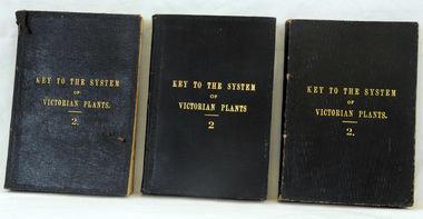
books, Robt. S. Bain, Key to the System of Victorian Plants 2, 1885
Ferdinand von Mueller was born at Rostock, Germany, on 30 June 1825 , died at Melbourne, Australia, on 10 October 1896. He studied pharmacy and took his Doctor of Philosophy at the University of Kiel in 1847. He came to Australia in 1848 for health reasons and became a great botanical collector and writer. He was Victorian Government Botanist from 1853, and for a time Director of the Botanic Gardens. He travelled widely in Victoria and was on the A.C.Gregory expedition to northern Australia in 1855-57. He supported botanical exploration and collecting throughout the colonies. 681.3 was presented to Carl Grove from G. Tadgell of Flemington. Charles Henry [Carl] Grove died on 17/4/1938 at Box Hill at the age of 88 and was buried in Orbost. Prior to coming to the Snowy River district, Carl worked as overseer on Buchan Station. In 1880, he selected land at Newmerella after first coming here in 1874 with early selector James A Robertson.He was one of the first selectors at Orbost - in 1880 he selected 320 acres at Newmerella, which he called „Ulinda‟ He married Annie Robertson in 1876. Carl was a farmer, hop and seed grower and nurseryman. He was an elected Councillor of the newly formed Tambo Shire in 1882, and then in 1892 to the Orbost Shire where he served for many years filling varioius public roles. In 1911, he shifted to Queensland, but later returned to Victoria and died at Box Hill. (Ref. Nov 2014 Newsletter) Mueller was one of the first people to take a scientific interest in Victorian forests, and argued against indiscriminate clearing of land. This item is a useful research tool. It is associated with Carl Grove, a prominent early resident of Orbost.Three copies of fabric bound book with a deep blue cover and the title, "Key To The System Of Victorian plants" in gold print. It has an ornate border around the edge.inside cover of 681.1 - To H. Grove, March 1891 Ulinda, Newmerella, Victoriaferdinand-von-mueller grove-carl botany plants-victoria -
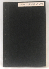 Orbost & District Historical Society
plans, 1966?
... plans-survey Snowy-River-Flats Department-Crown-Lands...-survey Snowy-River-Flats Department-Crown-Lands-Victoria A flat ...These survey plans are a useful research tool.A flat green fabric folder with a white label with "SNOWY RIVER FLATS" hand-written in black. It contains plans.plans-survey snowy-river-flats department-crown-lands-victoria -
 Orbost & District Historical Society
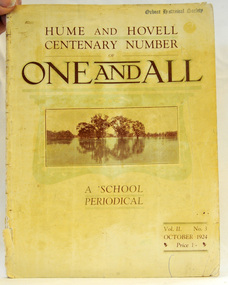
magazine, Clothier & Co, One And All, 1924
This magazine was circulated amongst the pupils, parents, and teachers of the Beechworth Inspectorate, North-East Victoria. This magazine is Vol. 2, no. 3 (Oct. 1924), Hume and Hovell Centenary Number.School magazines were the forerunners of today's school newsletters and were generally published annually. They are contemporary records of the students and staff of the school and usually contain examples of the students' work.This one, published to commemorate the centenary contains information on the Hume and Hovell expedition the purpose of which was to find new grazing land in the south of the colony, and also to find an answer to the mystery of where New South Wales's western rivers flowed. At the centenary of Hume and Hovell exploration in 1924 a committee was formed to co-ordinate and organise local celebrations along the route from Albury to Corio Bay. A roadside cairn was unveiled near Beechworth.A stapled school magazine with a cream coloured cover. It has an illustration of a river and trees reflected in the water on the front. The title, "ONE AND ALL" is at the top in black print. It has " Hume and Hovell Centenary Number" above the title.education-beechworth school-magazine-one-and-all -
 Orbost & District Historical Society
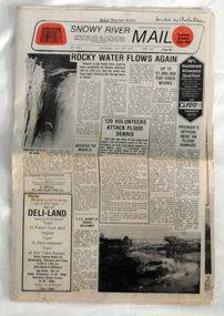
newspaper, Snowy River Mail, June 14 1978
Orbost has been subject to major floods throughout its history, such as those which left the town isolated in 1934, 1952, 1971 and 1978. It is recorded that the Snowy River broke its banks and flooded the flats 104 times between 1884 and 1978. Extensive flooding in Eastern Victoria during June 1978, caused widespread damage to roads, road closures and hazards to traffic, particularly over the Queen's Birthday holiday weekend.Since 1890 the Snowy River Mail has been the local newspaper of the Orbost district.This local paper has been the means by which readers in Orbost were able to learn about newsworthy events and issues in their local community for over a century. This paper is a contemporary record of a significant event in Orbost's history of flooding.A newspaper, Snowy River Mail, which contains black / white photographs of the 1978 floods in Orbost.orbost-floods-1978 -
 Orbost & District Historical Society
book, Grove, Carl, BUKAN MUNGEE
C.H. Grove spent about 40 years in the area, information is mainly derived from his own recollections and "reliable sources". Charles Henry [Carl] Grove died on 17/4/1938 at Box Hill at the age of 88 and was buried in Orbost. Prior to coming to the Snowy River district, Carl worked as overseer on Buchan Station. In 1880, he selected land at Newmerella after first coming here in 1874 with early selector James A Robertson.He was one of the first selectors at Orbost - in 1880 he selected 320 acres at Newmerella, which he called „Ulinda‟ He married Annie Robertson in 1876. Carl was a farmer, hop and seed grower and nurseryman. He was an elected Councillor of the newly formed Tambo Shire in 1882, and then in 1892 to the Orbost Shire where he served for many years filling varioius public roles. In 1911, he shifted to Queensland, but later returned to Victoria and died at Box Hill. (Ref. Nov 2014 Newsletter) This is a useful reference tool.A carbon copy of a typeset manuscript / transcript book entitled "Bukan Mungee" containing historical and geographical information of the area "bounded by the Snowy River in the east, the Tambo river in the west...and with the following leaseholds, Ensay, Gillingall, and Gelantipy on the north, with Kilmore and Corringle stations on the south..."grove-carl bukan-mungee corringle newmerella snowy-river tambo-river -
 Orbost & District Historical Society
albums
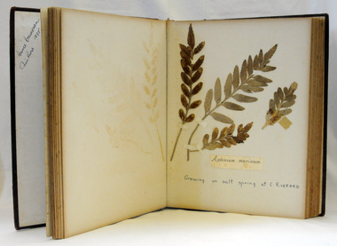
Annie Cameron was the daughter of John and Elizabeth Cameron. Her father was a keen geologist and botanist. Robert Pullar Cameron was a Shire Councillor for many years. He married Penuel Hossack and had a family of James, Flora, Penuel and Alex. He was listed as a significant plant collector at Orbost, Victoria who collected on the Bemm, Cann and Snowy Rivers. (Based on the list published by J.H. Willis, D. Pearson, M.T. Davis, and J.W. Green, Western Australian Herbarium Research Notes Number 12, August 1986. Enhanced with information from George, A.S. (2009) Australian Botanist's Companion, Four Gables Press, WA.)These items are significant as a record of the occurrence of a plant species at a particular place and time and are a useful research resource. They are associated with the Cameron family, early Orbost settlers. Two albums of pressed flowers. 765.1 has a red cover with gold trim and printing. 765.2 has a blue cover. 765.1 - "Collected at Cann River 1874-98 by Annie Cameron " 765.2 - "Collected we believe by Robert P. Cameron in 1890's"botany australian-plants-flowers cameron-robert-pullar cameron-annie -
 Orbost & District Historical Society
Victorian Railways pencil, Victorian Railways, c. 1960s-1980s
Used by Victorian Railways at stations on the Orbost-Bairnsdale line. The Bairnsdale-Orbost railway was opened in 1916 to serve the agricultural and timber industry. Because of the decline in traffic and heavy operating costs, the line was finally closed in August, 1987. Orbost Railway Station was opened on Monday 10 April 1916 as the terminus of the Orbost railway line, and closed in 1987. The station was located on the west side of the Snowy River despite the town of Orbost being on the east side of the river, in order to save on the costs of a bridge over the river, which at the time had highly variable levels. This item is associated with the history of the Orbost-Bairnsdale railway line and therefore reflects the role that the rail line played in the social and economic history of Orbost.A thick, hexagonal shaped pencil made of wood, painted dark blue, containing blue graphite marker.VICTORIA RAILWAYS written in gold lettering Emperor, Made in Australia railway-history victorian-railways orbost-bairnsdale-railway -
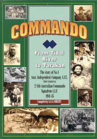 Australian Commando Association - Victoria
Commando. From Tidal River to Tarakan- Story of 2/4th Independent Company
-
 Australian Commando Association - Victoria
Film, Australian Commando Association et al, Double Diamond Commandos, 2019
A 2019 produced history of the initial training at Wilsons Promontory, Victoria of Australian and New Zealand Independent Companies later renamed Commandos and their activities during WW2 and post war development. Tidal River is the birth place of Australian and New Zealand Commandos and later Special Operations personnel.Short documentary film ww2, world war 2, independent company, commando, australian special forces, tidal river, wilsons promontory -
Australian Commando Association - Victoria
Mixed media - From Tidal River to Timbered Knoll, Education Package - From Tidal River to Timbered Knoll
This training package was produced by AVA Vic for use within the Victorian educational curriculum for years 10 to 12. It is particularly focused on those students who are attending Wilsons Promontory National Park and undertaking educational activities through the Parks Victoria Education Centre. The eight module program and teachers notes provides a historical workbook for students to gain a better understanding of the role of Tidal River as the initial training location for Australian and New Zealand commandos during World War II and the later military operations that were undertaken by commandos during World War II.Using original World War II footage, supplemented by later official record data this video and training package provides unique material regarding the history of Australian special operations during World War II.ww2, world war ii, independent companies, commando companies, australian special forces, tidal river -
 Orbost & District Historical Society
black and white photographs, 1934
These photographs were taken just after the McKillop's Bridge was completed after the flood damage. The current McKillop’s Bridge was built by the Country Roads Board in two stages between 1931-36, during which its height was raised after the original bridge superstructure was washed away in record floods of January 1934, prior to its original official opening. In its reconstructed form the original concrete abutments were turned into additional piers and the welded-steel trusses were cantilevered back over them to meet the new higher road approaches. It is sited at McKillops Crossing, named after pioneer overlanding squatter George McKillop who crossed here in 1835. This was a stock crossing place for almost a century before the bridge was constructed. (info. from Victoria Heritage Register)This is a pictorial record of the history of McKillop's Bridge, in itself of historical significance for its association with Victoria's long and important pastoral history, its technicl significance and aesthetic significance.Three black / white photographs. 3133.1 shows the approach to a washed away bridge. 3133.2 is of a bridge over a river with men clearing debris. 3133.3 is a close-up showing the wreckage of the bridge.mckillop's-bridge snowy-river flood-damage-1934 -
 Orbost & District Historical Society
black and white photograph, late 19th - early 20th century
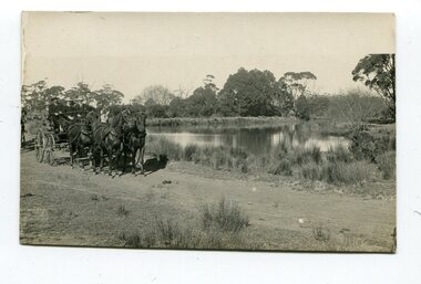
... and Brodribb Rivers. The Snowy River starts in New South Wales... and Brodribb Rivers. The Snowy River starts in New South Wales ...This photograph was taken at the junction of the Snowy and Brodribb Rivers. The Snowy River starts in New South Wales on the slopes of Mt Kosciuszko, Australia’s highest mountain, in New South Wales. It flows into Bass Strait at Marlo in Victoria. The Brodribb River is a tributary of the Snowy which enters the estuary at Marlo. This is a pictorial record of a road in Marlo near Orbost in the late 19th-early 20th centuries. It also depicts the transport used at that time.A black / white photograph of four men in suits seated in a horse - drawn buggy on a dirt road alongside a creek or river. There appears to be another horse - drawn vehicle behind them.on back - "at the Brodribb - Snowy junction. this road was corduroy (packed logs of tea trees?)brodribb-river snowy-river marlo transport-horse-drawn -
 Orbost & District Historical Society
May 1900
... photographs held in The State Library, Victoria. The Snowy River Mail... photographs held in The State Library, Victoria. The Snowy River Mail ...This is a photograph of the original Orbost / Snowy River Bridge , a suspension bridge which opened in 1893. It has been taken when the Snowy River was in flood. It is similar to other photographs held in The State Library, Victoria. The Snowy River Mail and Tambo and Croajingolong Gazette Sat 12 Aug 1893 records the opening of this bridge as "the most important public event that has yet been commemorated in Eastern ......The Messrs McLeod, with whom the first settlement of this district is generally associated, took up their residence on the eastern bank of the Snowy River about the year 1841 or 42. The late Mr W. Roadknight and Mr T. T. Stirling took possession of the territory on the western side of the Snowy about 35 years ago. During the occupation of the country by cattle owners, very little progress was made in the way of roads and bridges, and except to the hardy and lexperienced bushman, it might have been generally regarded as inaccessible. About the year 1877, however, the late Mr James Robertson eldest son of Mr James Robertson, of Lochend farm, selected land now occupied by his father, about four miles from Orbost on the west bank of the river, Mr John Cameron visited the. district shortly after a .tour of inspection and returned later with his brothers, James and Alick Gameron, but found that during their absence Mr Ernest Watt had found his way on the scene and pegged out a selection, thus anticipating the advent of the Camerons by about 12 hours. We understand that a Mr Kidd, who selected the property now occupied by Mr W. J. Ross, at Pumpkin Point, was one of the earliest batch of settlors.........."This is a pictorial record of an early bridge across the Snowy River at Orbost.A black / white photograph of a suspension bridge with flood waters below the bridge.orbost-bridge suspension-bridge snowy-river -
 Orbost & District Historical Society
postcard series, 1960s
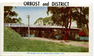
Included are photographs of the Orbost township, the Snowy River at Marlo, Gypsy Point, Buchan Caves and Bairnsdale. In the 1960s Orbost had a population of 4000 and was a major tourist attraction in Eastern Victoria with sufficient accommodation and facilities. It was the major town close to several national parks with access to either the surf or the snow. These postcards are pictorial records of Orbost in the 1960s. Postcards are very interesting records of places. architecture and transport.A colour postcard series with photographs of Orbost and the district. The cover photograph is of the Snowy River Bridge. There is an information card.Each photograph is labelled. at the bottom.postcards-orbost postcards-east-gippsland -
 Orbost & District Historical Society
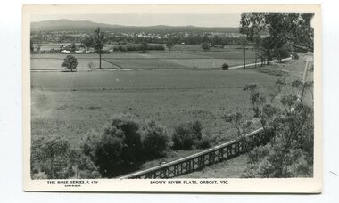
black and white postards, Rose Stereograph Company, 1940s -1950s
These postcards are part of the Rose series of photograph / postcards taken around Victoria. Rose was born in Clunes in 1861 and later worked in his father’s boot-making business in Prahran while studying photography. In 1880 he founded the Rose Stereograph Company and became famous for producing stereographs, or stereoviews, which gave the illusion of being in 3D when seen through a hand-held viewer, a big craze of the era. Rose produced stereoviews of the Western Front during the First World War. In all, he took about 9000 images in about 38 countries. As stereographs lost popularity in the 1920s, Rose switched to production of postcards and decorative cards, and he and the photographers who followed took thousands of scenes around Victoria as well as interstate that became iconic images of Australian life.These postcards are pictorial records of Orbost in the mid 20th century.Postcards such as these were a way of showing the scenic attractions of Orbost to potential tourists.Three black / white postcards of views over the Orbost flats and railway viaduct. 3183.1 is of a railway viaduct in the foreground and farming flats. 3183.2 is a view over the Orbost flats taken from Grandview Lookout. 3183.3 is a view from the Grandview Lookout showing the back of a woman looking across a rail fence. 3183.1 - bottom front - Rose Series P 478 SNOWY RIVER FLATS, ORBOST VIC 3183.2 - bottom front - Rose Series P 49 ORBOST, FROM GRANDVIEW HEIGHTS,VIC 3183.3 - bottom front - Rose Series P 14443 A VIEW FROM THE LOOKOUT, ORBOST, VICpostcards-orbost rose-series orbost-railway-viaduct grandview-lookout-orbost -
 Orbost & District Historical Society
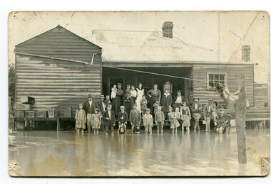
black and white photograph, poss. 1920
In the photograph are the Rice family, Billy Nixon' family and Charlie Johnston. William Nixon, son of James Nixon and Alice (Roberts) Nixon was married to Ilma Muriel (Cadwallader) Nixon on 2 Apr 1902 in Orbost. They had six children - Llewella Adele (Nixon) King, Sydney William Columbo Nixon, Arthur Harry Nixon, Jack Warton Nixon, Claudine Frances (Nixon) Taylor and Daphne Joyce (Nixon) Menz Damage estimated at £500,000 was caused by the 1934 floods in the Orbost district. This 1934 flood was devastating, destroying a section of the 1922 Orbost bridge, wrecking fences, bridges and roads, dumping silt and debris on the rich river flats and drowning cattle. Note: although this card has the date 1934 written onto the rear, the flood incident depicted most likely dates from 1920 (ref. Weekly Times, Saturday 6 March 1920 p 41 when this photo was printed).This item is a pictorial record of a flood in 1920 (ref. Weekly Times, Saturday 6 March 1920 p41). Snowy River flood are a feature of the Orbost area. These floods cover the rich agricultural land. A black / white photograph / postcard of a group of people standing in floodwaters outside a timber building. Included are young children and babies being held by women. Two boys are holding dogs in front of them.on back - "Billy Nixon's house (now Downys 1991)"orbost - floods - nixon - 1920 -
 Orbost & District Historical Society
black and photograph / postcard, 1.4.1908
... in The State Library, Victoria. The Snowy River Mail and Tambo... in The State Library, Victoria. The Snowy River Mail and Tambo ...This postcard was sent to Annie Gilbert (Mrs John Gilbert) of Tullagoota, Orbost. It was written by "Grace", probably her sister, Grace Cameron Annie Gilbert was the daughter of John Cameron who selected the first land on the Snowy River flats. This is a photograph of the original Orbost / Snowy River Bridge , a suspension bridge which opened in 1893. It has been taken when the Snowy River was in flood. It is similar to other photographs held in The State Library, Victoria. The Snowy River Mail and Tambo and Croajingolong Gazette Sat 12 Aug 1893 records the opening of this bridge as "the most important public event that has yet been commemorated in Eastern ......The Messrs McLeod, with whom the first settlement of this district is generally associated, took up their residence on the eastern bank of the Snowy River about the year 1841 or 42. The late Mr W. Roadknight and Mr T. T. Stirling took possession of the territory on the western side of the Snowy about 35 years ago. During the occupation of the country by cattle owners, very little progress was made in the way of roads and bridges, and except to the hardy and lexperienced bushman, it might have been generally regarded as inaccessible. About the year 1877, however, the late Mr James Robertson eldest son of Mr James Robertson, of Lochend farm, selected land now occupied by his father, about four miles from Orbost on the west bank of the river, Mr John Cameron visited the. district shortly after a .tour of inspection and returned later with his brothers, James and Alick Gameron, but found that during their absence Mr Ernest Watt had found his way on the scene and pegged out a selection, thus anticipating the advent of the Camerons by about 12 hours. We understand that a Mr Kidd, who selected the property now occupied by Mr W. J. Ross, at Pumpkin Point, was one of the earliest batch of settlers.........."This item is associated with Annie Gilbert (nee Cameron) reported to have been the first white girl to be born in Orbost. It is a pictorial record of the suspension bridge over the Snowy River which has since been replaced twice.A faded black / white postcard of a bridge across a river. There are cattle in the river and the banks are tree-covered.on back - a hand-written letter addressed to Mrs J. Gilbert Tullagoota Orbost.cameron-annie suspension-bridge-orbost snowy-river-orbost -
 Orbost & District Historical Society
postcards, 2008
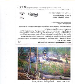
These postcards were made for sale in the Orbost Ehibition Centre. The Snowy River Talking Wall is on the lower outside of the Orbost Exhibition Centre. The cards relate the history of Orbost both indigenous and white. The contributors are: Barry Miller; Gary Green; Becky Illume; Dawn Van Den Berg; Ruth Hansen; Geordie Webb; Graham Falls; Laurie Harvey and Jonathon Renn. The Orbost Exhibition Centre is a community based, not-for-profit arts and entertainment center in Orbost, Victoria. It is the home to the National Wood Design Collection and the Annual Australian Wood Design Exhibition. Wood Workers of Orbost and District initiated the Orbost Exhibition Centre back in 1997 and it was opened in 2004. (from web-site)These postcards are pictorial advertisements for Orbost. They are associated with the Orbost Exhibition Centre, an important tourist attraction, in the town.A set of eleven coloured postcards. Each depicts a section of the Snowy River Talking Wall. Each is a folded rectangle of cardboard with a photograph of a section of the display and information relating to it.talking-wall-orbost postcards orbost-exhibition-centre -
 Orbost & District Historical Society
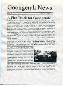
newsletters, Goongerah Grapevine, July 1998 - August 2005
Goongerah is a community on the Brodribb River, located in Gippsland, about seventy kilometres north of Orbost. The town's population is about sixty. Goongerah Post Office opened on 21 November 1952 and closed in 1974. Goongerah had one of the smallest primary schools in Victoria, with about 11 students. The school no longer functions. These newsletters were produced by members of the community and distributed locally.In small rural communities newsletters have been important tools for facilitating community development while fostering a sense of belonging and attachment to the community.A yellow plastic covered folder containing black / white printed newsletters. There are fifteen copies of "Goongerah Community News" and thirty-nine copies of "Goongerah Grapevine". All include news from the C.F.A., Forest News and articles from Goongerah Primary School.label on front- "COMMUNITY NEWSLETTERS Goongerah 1998 - 2005"