Showing 10967 items
matching maps
-
 Ringwood and District Historical Society
Newspaper, Scrapbook Clipping, Library Collection, Ringwood, Victoria, `
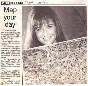
``Newspaper clipping from "The Mail" 1-6-94 OUR people Map your dayThe Ringwood Council's recent launch of an exciting and innovative promotional map means that residents have recreational information at their fingertips. The "Recreation in Ringwood"poster details recreational pograms, services, clubs and facilities throughout the city` -
 Federation University Historical Collection
Map, Ballaarat Gold Field, 1861, 1861
A party of surveyors camped by Yuille's Swamp (later Lake Wendouree) and surveyed the countryside for a map to be produced by the Geological Survey of Victoria. In November 2004 the Central Highlands Regional Library presented a special edition of 200 copies of the 1861 map reproduced from a copy in their collection. Original 1861 map of Ballarat showing streets and leads. Blue dots indicate gold leads, and red lines indicate auriferous quartz reef and outcrops of quartz veins."Compiled & Drawn from the Survey of Mining Surveyors Davidson, Fitzpatrick and Cowan & the Plans in the Surveyor General's Office by J. Brahe, 21st October 1861. R. Brough Smyth, Secretary for Mines. The Honourable J.B. Humffray, M.L.A. Commr of Mines.”ballarat, map, ballarat east, lake wendouree, survey, mines, robert davidson, ballarat gold field 1861, yuille's swamp, wendouree swamp, little bendigo diggings, gold leads, old post office hill, specimen hill, bakery hill, black hill, dead horse creek, brown hill, pennyweight hill, clayton hill, soldiers hill, golden point, gum tree flat, white flat, poverty hill, chinese village, robert brough smyth, ballarat map 1861, ballaarat vineyard, dead horse gully, deadhorse creek, invermay, black hill flat, gaelic church, police reserve, magpie range, dalton's flat, caadian lead, rifle butts, powder magazine, bathing house, government camp, gold office, chinese, llanberrris, victoria theatre, charlie napier hotel, united states hotel, grape's hoel, clayton's hill, cattleyard hill, free trade hotel, esmond lead, bakery hill, black hill lead, juvenile reformatory, ballarat orphanage, lady barkly lead, triffet's slaughter yard, little bendigo, melbourne road, t. cowan, thomas cowan -
 Tatura Irrigation & Wartime Camps Museum
Button - brass, P J King Pty Ltd, 1940's
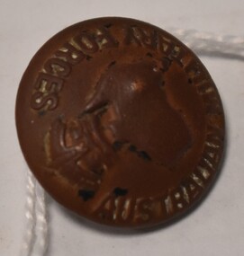
Found at POW camp 13 site post war by war time camp guardBrass button with Australian Military Forces around front edge, map of Australia in centre with a crown above. Has a brass loop on the back to attach to clothing. Contained in a black material covered display case with gold around edge.on front: Australian Military Forces and a map of Australia and crown. on back P J King Pty Ltd Melbbrass buttons, camp 13, military uniform accessories -
 Whitehorse Historical Society Inc.
Map, Shires of Boroondara, Nunawading, C1856
... Maps ...Photocopy of part of very early map covering parts of Boroondara and Nunawading.Photocopy of part of very early map covering parts of Boroondara and Nunawading. Marks old tracks on lines of Whitehorse and Canterbury Roads.Photocopy of part of very early map covering parts of Boroondara and Nunawading.maps, shire of nunawading, shire of boroondara, barkers track, deep creek, nunawading -
Whitehorse Historical Society Inc.
Pamphlet, Bellbird Dell
A pamphlet about a municipal reserve - Bellbird Dell, with a list of names of the Management Committee.A pamphlet about a municipal reserve - Bellbird Dell, with a list of names of the Management Committee. Also states they are looking for helpers for regular working bees. Includes map of reserve.A pamphlet about a municipal reserve - Bellbird Dell, with a list of names of the Management Committee.local government, city of nunawading, bellbird dell, vermont -
 Phillip Island and District Historical Society Inc.
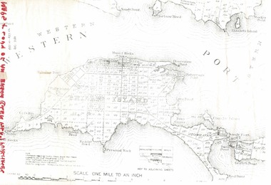
Document, 1869 Crown Land sale and map of Phillip Island showing allotments
... maps ...Anderson and McHaffie were prominent early settlers of Phillip Island. These documents were from the estate of Stan Mcfee snr. Listings of auctions at Gemmell, Tuckett & Co., Collins Street, Melbourne 12 February, 1869HistoricalCopy of map showing allotments for 1869 land sale and hand written note showing allotments, area, prices for purchases of Robert Anderson and notes on McHaffie land.robert anderson, glen isla, john mchaffie, maps, land sales -
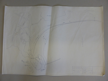
 Bendigo Military Museum
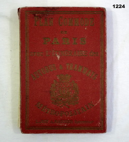
Plan - MAP, TOURIST, L Joly, A Maunier, WWI
The map belonged to Jack Grinton No 1043 38th Batt AIF. At Wars end extensive leave was granted, Jack journeyed to Paris, Nice, Monte Carlo taking many photos. Part of the Grinton collection which included hundreds of negatives and developed photos that he took during the War. Refer Cat No 1280 for service details. Refer 1317P, 1320P.Map of Paris. Red cardboard or paper hardcover, new edition guide of metropolitan Paris (ministries, tramways, monuments), Index in front, folded paper map attached to back cover. "Plan commode de Paris avec l'itineraire des autobus & tramways metropolitan"documents-maps, french -
 Doncaster RSL Sub Branch
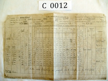
Papers Bomber D4854
Maps 11-02-43 Wilhelmshaven,8-03-43 Nurnburg 27-03-43 Berlin, logs Nurnburg and Berlin. Lancaster Squadron 156 Pathfinder RAF Warboys Huntingdonshire.Sgt. Patrick Brougham(Faddy) Commenced operations Feb 1943 killed on operation to Skoda16-04-1943 aged 18 1/2, buried with his six companions Brimond near Rheims France.Maps three Missions and Engineers log for two missions -
 Warrnambool and District Historical Society Inc.
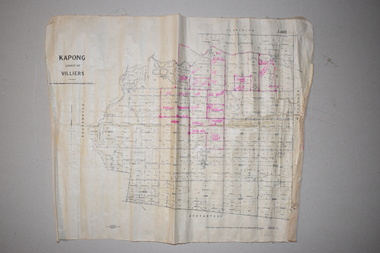
Maps (2), 1 Kapong .2 Hawkesdale, 1 1913 .2 1942
These two maps of the Kapong/ Hawkesdale area in Victoria show the original lands that belonged to the pioneer settler, Charles Hamilton MacKnight and the handwritten annotations that show the subsequent owners of these lands. Charles Hamilton Macknight (1819-1873) came to Australia from Scotland in 1841 and in 1842, with partners, James Irvine and William Campbell, established the property of Dunmore in Broadwater (24 kilometres from Hawkesdale). He was a prominent breeder of sheep, cattle and horses. Sections of his lands were acquired by the Baulch family and these maps were acquired from a member of the Baulch family, with Stanley Baulch being the possible annotator of the Kapong map. These maps are of interest as they show the properties that belonged to the pioneer settler, Charles Hamilton MacKnight and the subsequent division of these lands, some of these passing into the hands of the Baulch family. As the Kapong map also shows other original landowners, it will be a useful tool for researchers..1 This is a map of Kapong in the County of Villiers. It is on a rectangular-shaped piece of linen-backed paper with black printing and some handwritten annotations in red ink. It is crumpled at the edges. .2 This is a rectangular-shaped piece of paper showing a map of the Hawkesdale area. The printed material is in grid form in black, green and red. At the left bottom edge it has a mauve stamp. kapong, victoria, hawkesdale, victoria, dunmore estate, victoria, charles hamilton macknight, baulch family, western victoria, history of warrnambool -
 Kew Historical Society Inc
Map, Department of Lands & Survey, Map of Melbourne & Suburbs, 1899
The Melbourne & Metropolitan Board of Works was established in 1891 to oversee the introduction of a sewerage and water reticulation system in Melbourne and its suburbs. This complementary map was produced by the Department of Crown Lands & Survey [Victoria] in the same decade showing the distribution of water in Melbourne for use by fire brigades. While by 1910, there were 123,227 connections to Melbourne's water supply system, it is unclear in this 1899 map whether water was supplied to all built structures in the defined areas or only to fire hydrants and stand pipes, as we know that the first connection of a building to the sewerage system in Kew only occurred in 1904.Map accompanying report on fire protection of Melbourne showing those areas supplied with water in colour.water reticulation -- melbourne (vic.), department of lands & survey -- historic maps, fire brigades -- melbourne (vic.), cartography -
 Shepparton RSL Sub Branch
Escape Map Cloth, July 1944
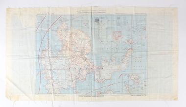
Silk escape map issued to Allied Airmen during World War 11 for the Pacific campaignsA silk escape map including detail of tides and winds was relevant to air force personnel in Pacific regions during WW2. Coloured Cloth Escape Map of Side A : No. C44 North Borneo Side B: No C43 Mindanao Island SCALE: 1:1,000,000; Wind and Current markings; AAF Cloth Cart- Philippine Series Prepared under the direction of the Commanding General, Army Air Forces, by the aeronautical Chart Service, Washington DC July 1944world war ii, second world war, silk escape map, pacific conflict -
 Bendigo Military Museum
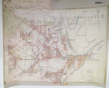
Map - Map of Newcastle NSW 4 Inch - 1 Mile 1910, Australian Intelligence Corps, Nov 1910
In 1909 the Australian Army Headquarters realized that mapping in Australia was either non existent or inadequate for Military use. It was requested that Australia borrow Survey personnel from the UK Royal Engineers (RE) for a two-year detachment. On 11 April 1910 four RE NCOs arrived in Melbourne comprising CPL J Lynch, and LCPLs AH Barrett, EF Davies and R Wilcox. LCPL Barrett had 12yrs experience with RE. They were aiming at producing eight map sheets per year covering about 7,000 square miles (18,000 square Km) This map sheet of the Newcastle area was produced using plane table methods and was surveyed and hand drawn by LCPL A Barrett Oct - Nov 2010. It was unique because it was now produced on an accurate gridded base and included contouring. Lynch and Davies transferred to the Royal Australian Engineers (RAE) whilst Barrett and Wilcox returned to the UK in June 1913. Barrett returned to Australia in 1915 and also enlisted in the RAE and served until 1919.A gridded Map of Newcastle NSW area scale four inches to one mile with 25 feet interval contouring. Coloured hand drawn map produced in 1910. Signed by " A Barrett LCPL Royal Engineers"royal australian survey corps, rasvy, fortuna, army svy regt, army survey regiment -
 Orbost & District Historical Society
map/brochure, Discovering Marlo & The Snowy River Estuary, December 1988
In 1983 the Department of Conservation, Forests and Lands replaced the Department of Crown Lands and Survey, the Department of State Forests and the Ministry for Conservation. This brochure/map was used as tourist information in Orbost.This item is a useful research tool.A folded map/brochure titled "DISCOVERING MARLO & THE SNOWY RIVER ESTUARY". On the front is a photograph of Marlo and the title in yellow print. There is a locality map for access to Corringle beach and the brochure Includes a key to fishing sites and various tourist locations. On the back of the brochure are notes on fishing, wildlife and a boating guide, map brochure snowy-river marlo -
 Warrnambool and District Historical Society Inc.
Map, Soil conservation authority:plan of high water marks at Lady Bay Warrnambool, 1984
This map documents the changing state of Lady Bay from around 1870 until 1976. It depicts the changing high water mark over that period and the main outlet of the Merri River in 1872 and 1976.This map provides a useful and significant insight into the ever changing face of Lady Bay from the 1870’s through to 1980’s. Cream paper map drawn with black ink showing Lady Bay and South Warrnambool section of Warrnambool. In lower RH corner Soil conservation AuthorityPlan of High water marks at Lady Bay Warrnambool. Drawn P.D. 19.1/84. Scale 1:3600. Written on back in black pencil: Lady Bay Historical HWM lady bay map, merri river 1872- 1976, merri river 1872- 1976, history of warrnambool -
Whitehorse Historical Society Inc.
Document, Fromelles, 2012
Transcription of talk on the Battle of Fromelles.Transcription of talk on the Battle of Fromelles by Lambos Englezos to Whitehorse Historical Society 14 April 2012. With map of battle area. Tape at NP 3908Transcription of talk on the Battle of Fromelles.world war 1914-1918, fromelles -
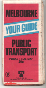 Melbourne Tram Museum
Ephemera - Map, Ministry of Transport, "Melbourne Your Guide PUblic Transport Pocket size map", 1979
Provided a detailed map of Melbourne's public transport, route number list and brief description. Has contact details for bookings and lost property etc. Priced 20c, published 1979 as map No. 9Demonstrates the methodology of providing map and transport information at the time.Fold out map (27 sections 9 across x 3 deep), coloured of Melbourne's Tram and Bus routes, route numbers, rail lines, detailed for the central part of Melbourne and insert section for Frankston. melbourne, map, tram and bus services, railways, mmtb, ministry of transport -
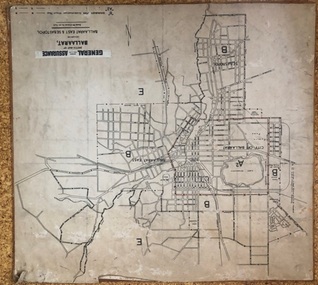 Ballarat Tramway Museum
Map, General Accident Fire and Life Assurance, "Sketch Map of Ballaarat including Ballaarat East and Sebastopol", c1940
... Maps ...Yields information about Ballarat c1940 and how the area was rate for insurance purposes.Map - paper mounted onto a heavy card backing titled "Sketch Map of Ballaarat including Ballaarat East and Sebastopol" with a printed label "General Accident Fire and Life Assurance" pasted to the top of the title. Drawn at 30chains to the inch. Map shows the boundaries between the carious insurance classifications in the district, which relates partly to the local government areas at the time. Shows the Yarrowee, Gong Gong Creeks, rail lines, stations, Black Hill and some other features. Includes the Explosives factory area. Does not show the tram lines.trams, tramways, ballarat, maps, insurance, sebastopol -
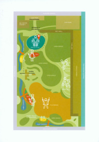 Glen Eira City Council History and Heritage Collection
Event Run-sheet and Map, "Booran Reserve Official Opening"
This run-sheet and map were used for the opening of Booran Reserve at the corner of Booran and Glenhuntly Roads on Tuesday 11 April 2017. The Reserve was officially opened by the Mayor, Cr. Mary Delahunty and The Hon. Philip Dalidakis, MP, Minister for Innovation. The run-sheet contains information about the Order of Proceedings of the opening ceremony. The map notes the locations of reserved parking, the route taken by Mayor Mary Delahunty and Minister Philip Dalidakis through the Reserve, and the speech and smoking ceremony site. The site of the Reserve was previously the Caulfield Service Reservoir.Black and white printed run-sheet, and green, teal, red, yellow, blue and khaki colour printed map -
 Warrnambool and District Historical Society Inc.
Map - An Angler's map of the Hopkins River Estuary, Angler's map Hopkins River, 1980s
This is a map of the Hopkins River Estuary prepared by Dr John Sherwood for the benefit of anglers. The information on the sheet includes the location of sand banks, the water depths, boat ramp facilities and public access facilities. Some of the information has been gathered from aerial photographs. The map has been produced by the Warrnambool Institute of Advanced Education which was developed in the late 1960s from the tertiary section of the Warrnambool Technical College and with all its departments established by 1984 at the Sherwood Campus five kilometres from Warrnambool on the Princes Highway. Today the site is occupied by Deakin University, Warrnambool campus. The Warrnambool Anglers’ Club has its headquarters on the banks of the Hopkins River near the mouth of the river and the Lyndoch Aged Care facility.This map is of interest as a specialist one, providing fishermen with detailed information on all aspects of the Hopkins river estuary. Fishing has been both a profession and a popular recreational pursuit for Warrnambool residents since the early days of the city’s settlement. The Hopkins River Estuary has been a focal point for fishermen throughout Warrnambool’s history. This is a sheet of paper folded three times to produce a folded map. The front cover has a black and white photograph of two fishermen with a large fish. The map of the Hopkins River Estuary is in yellow, blue and black and covers the side of one sheet and three quarters of the other side. There is an advertisement for the Hopkins River Boathouse with a black and white sketch of the boathouse and notes on the map written by Dr John Sherwood. There are several diagrams showing the water depths. The map has some silverfish damage and some tearing at the folds. warrnambool anglers’ club, history of warrnambool, hopkins river, hopkins river estuary, john sherwood -
Tatura Irrigation & Wartime Camps Museum
Folder - survey maps
Maps of no 14 A, B, C and D internment camps and documents on Loveday Camp, South Australia. Donated by Gerhard Meinke concerning Loveday Camp. Brief outline of camps life, release and repatriation, list of deaths, of POW's and internees.Blue back clear plastic folder containing maps of No 14 camp and documents on Loveday Camp.gerhard meinke, loveday camp, camp 14, south australian internment camps, japanese internees -
 City of Kingston
Pamphlet - Colour, H. R. Hill & Co, Walker's Estate, Cheltenham for sale by public auction, c. 1923
Sales plan for land in the suburb of Cheltenham, encompassing both sides of Walker Grove, a section of Centre Dandenong Rd and Axelton St. The developing urban area of Cheltenham within the City of Kingston. This land sale pamphlet illustrates the subdivision of land within the municipality and the changing demographic of the district as new houses are constructed.Black and white pamphlet advertising for private sale the Station Entrance Estate, Highett. Incorporates a map of the estate bordered by Wickham Road, Railway Parade, Highett Road and Point Nepean Road.Handwritten in black pen on subdivision map: 'x' written on subdivisions 2, 3, 8-11, 15-17, 19. Potentially indicating that these properties did not sell at auction. Handwritten in black pen on subdivision map: assumed sale price on subdivisions 1, 4-7, 12-14, 18, 20-31. land sales, cheltenham, estate -
 Kiewa Valley Historical Society
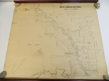
Map - Kiewa Valley, Parish Map of Mullindolingong, 12/10/1906
The map shows the names of people living in the parish of Mullindolingong in 1906. These people had leases or licences giving the reader an insight into the number of people in the area and an understanding of the size of their holdings. Infrastructure is also given including shops, schools, churches etc. Presumably it was used by the Ryder family.This map gives an historical insight into the parish of Mullindolingong as it names people and the infrastructure - roads, buildings etc. as it was in 1906. This enables the reader to compare the area at the time with other times and other places and to have an understanding of the early settlers in the area.This is a very old paper or parchment map with wooden rods top and bottom. The top rod has ribbons attached to enable hanging. The map shows the current leases and licences and when they were held by during this period, circa 1906.Mullindolingong County of Bogong. This plan has been prepared by The Most Reliable Data in the Possession of the Department up to the date of its Compilation. Information respecting Leases or Licences which await Final Completion is not recorded.parish of mullindolingong map; ryder family; early settlers; -
 Federation University Historical Collection
Map, Ballaarat Gold Field, 1861, 21/10/1861
A party of surveyors camped by Yuille's Swamp (later Lake Wendouree) and surveyed the countryside for a map to be produced by the Geological Survey of Victoria. In November 2004 the Central Highlands Regional Library presented a special edition of 200 copies of the 1861 map reproduced from a copy in their collection. Original geological map of Ballarat showing property, waterways, mines, churches, schools, water races, and garden reserves. It was compiled and drawn from the surveys of Mining Surveyors Davidson, Fitzpatrick and Cowan.Compiled & Drawn from the Survey of Mining Surveyors Davidson, Fitzpatrick and Cowan & the Plans in the Surveyor General's Office by J. Brahe, 21st October 1861. R. Brough Smyth, Secretary for Mines. The Honourable J.B. Humffray, M.L.A. Commr of Mines.ballarat, map, davidson, robert brough-smyth, fitzpatrick, cowan, yuille's swamp, public garden reserve, manure depot, black hill, ballarat east, old post office hill, pennyweight hill, claytons hill, golden point, mining, railway, cricket ground, swamp creek, cemetery, sludge reserve, bakery hill, gaelic church, juvenile reformatory, orphanage, specimen hill, eureka lead, cattle yard hill, dalton's flat, chinese village, poverty hill, railway reserve, little bendigo diggings, pound reserve, allied armies, flour mill, agricultural reserve, marsh, survey reserve, survey corps, white flat, yarrowee, yarrowee creek, brache, j. brache, survey, ballaarat gold field 1861 -
 Bendigo Military Museum
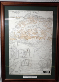
Map - MAP, NEW GUINEA FRAMED, 1941 onwards
Map of Western section of New Guinea. Black print on white background with mountain ridges in tan. Mounted with green border & brown wooden frame, glass front & white cardboard backing with wire hanging strap on back. Inset LHS bottom: A: Aroe Island B: KIA Island C: Taniimba IslandPrinted in black at top centre: “NEW GUINEA WESTERN’ Printed on border under map: “These escape maps were carried in the zip pockets of life jackets by fighter pilots in WW2. This map was presented to A.S.R. on the 12/7/79 by Councillor Ian McKenzie, Mayor of Eaglehawk, who served as a fighter pilot in 78th SQN in S.W. Pacific area during 1943-44.”map, new guinea, western, raaf -
 Melbourne Tram Museum
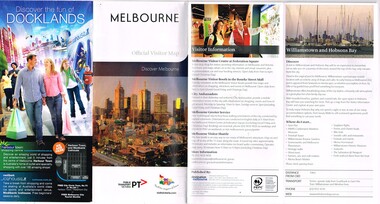
Pamphlet, Public Transport Victoria (PTV), "Melbourne Official Visitor Map", 2012 to 2019
... Maps ...Set of 6 pamphlets - folded to DL size - full colour - each titled "Melbourne Official Visitor Map" giving location of various Melbourne attractions, transport information, ticketing, Myki, and visitor information. Has two maps - Melbourne and the inner suburbs and the CBD + Southbank area. .1 - 14 - fold - published 2012 - 13 - has standard tram and rail maps as well. .2 - 14 fold - published 2013 - 14, also has a map of Melbourne laneways. .3 - 12 fold - published 2016 - has D 3523 on front cover outside Flinders St Station. .4 - 12 fold - published 2015 - map of City Centre and Inner Melbourne, .5 - 12 fold - published 2017 - as above. .6 - 12 fold - published 2019 - as abovetrams, tramways, melbourne, ptv, maps, tramways, railways, tram 3523 -
Port Melbourne Historical & Preservation Society
Map - Large map of Port Melbourne, British Chart, Japanese war-time map of Port Melbourne, c 1937
Jim Sinclair was born in Cruickshank Street, Port Melbourne in 1924. During World War II Jim found this map in a network of caves near Rabaul, Papua New Guinea. He remembers '"The Japanese] had linked just about every hill with a tunnel. Concreted. Most of them were packed with stuff. I used to wander through - being very careful too, mind you!. You didn't want yourself to get blown up. I found these maps. I thought that looks familiar! It's in English with Japanese stuff on it too."A large map of Port Melbourne with Japanese printed annotations with strategic infrastructure. Stamp on back explains age in Japanese.war - world war ii, port of melbourne, jim sinclair -
Hume City Civic Collection
Print - Street Directory, Gregory"s Melbourne Street Directory, c1972
... Maps ...This street directory was published by Gregory's Guides & Maps Pty Ltd of 142 Clarence Street, Sydney NSW in c1972. It was used by the donor's family for many years to navigate their way around Melbourne and the metropolitan area. A street directory enclosed in a black leather detachable cover with gold embossing of a car on the front cover.Gold embossed vintage car on front of detachable cover.joan houston, streets, roads, maps, street directory -
Kew Historical Society Inc
Book, Lansdowne, 100 Years Of Australians At War, 1999
400 p., [64] pages of plates : ill., maps, ports. ; 24 cm. non-fictionkorean war 1950-1953 - history, persian gulf war 1991 - history, south african war 1899-1902 - history, world war 1914-1918 - history, australia - armed forces - history, australia - history, military., world war 1939-1945 - history, wwi -
 Kew Historical Society Inc
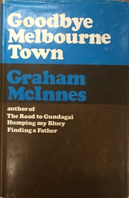
Book, Hamish Hamilton, Goodbye Melbourne Town, 1968
London, H. Hamilton, 1968 xii, 211 p. map. 23 cm. non-fictionmelbourne - history, graham mcinnes (1912-1970) -
 Kew Historical Society Inc
Book, Helen Baker, Historic Buildings: Windsor and Richmond, 1967
[Sydney], 1967 67 p. : illus., facsims., maps, plans ; 26 cm. non-fictionhistoric buildings - windsor (nsw), historic buildings - richmond (nsw)