Showing 11614 items matching " maps"
-
 Bendigo Military Museum
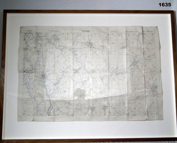
Map - TRENCH MAP, FRANCE WW1, FRAMED
Belonged to JOHN WILLIAM GRINTON No 1043 C Coy 38th Batt AIF. Refer Reg No 1280 for Service Details also 1317P, 1319P. Refer 1634P for the story on the map.Trench map of France - Edition 5A Bellicourt - Montbrahain - Bran Court. Tan, wooden frame, glass front with white cardboard backing. Hanging wire attached at back with centre strengthening brace. Map stuck on white background. German trenches in blue. Top middle: France. RHS bottom rear: The Union Studio - Castlemaine sticker.documents - maps, frame accessories, military history - army -
 Bayside Gallery - Bayside City Council Art & Heritage Collection
Map, Department of Lands and Survey, Land under the control of the City of Sandringham, 1962
The cadastral map showing land under the control of the City of Brighton in 1962.map, plan, foreshores, sndringham, hampton, beaumaris, cheltenham, department of lands and survey, cartographic material, moorabbin, black rock, street map, city of sandringham, board of lands and works -
 Kew Historical Society Inc
Book, Geoffrey Blainey, A History of Camberwell, 1980
104p., [20]p. of plates : ill., map, ports. ; 22cm.non-fictioncamberwell (vic.) -- history, victoria -- camberwell. -
Kew Historical Society Inc
Book, Geoffrey Blainey, A History of Camberwell, 1964
104p., [20]p. of plates : ill., map, ports. ; 22cm.non-fictioncamberwell (vic.) -- history, victoria -- camberwell. -
Kew Historical Society Inc
Book, Dorothy Rogers, A History of Kew, 1973
xvi,256p. : maps on lining papers, plates, tables ; 24cm. non-fictionkew (vic.) -- history., melbourne -- kew 1840-1972 -
Kew Historical Society Inc
Book, Dorothy Rogers, A History of Kew, 1973
xvi ,256p. : maps on lining papers, plates, tables ; 24cm. non-fictionkew (vic.) -- history., melbourne -- kew 1840-1972 -
Kew Historical Society Inc
Book, Powerline Review Panel, Final Report to the Victorian Government, 1989
Final Report to the Victorian Government of the Powerline Review, 1989264 p. in various pagings : ill., maps ; 30 cm.non-fictionFinal Report to the Victorian Government of the Powerline Review, 1989electric power distribution -- victoria -- brunswick, electric power distribution -- victoria -- richmond -
Whitehorse Historical Society Inc.
Map, Parish of Nunawading, 1927
... Maps ...Map of the Parish together with part of the Borough of Box Hill.Map of the Parish together with part of the Borough of Box Hill. Includes names of lease or license holders, sizes of leases and in some areas dates of leases. Roads, railway and stations marked. Original survey by W.J.Busocon, 1915. Manuscript note: 15.2.1927 Verified Dept. Lands and Survey.Map of the Parish together with part of the Borough of Box Hill. maps, parish of nunawading, borough of box hill -
 Bendigo Military Museum
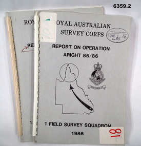
Administrative record - Royal Australian Survey Corps Report on Operation Aright 85 / 86 1 Field Survey Squadron 1986, 1986
Operation ARIGHT 85 was mounted by 1 Fd Svy Sqn 14 May to 8 Aug 1985 and 1 May to 15 May 1986. In the 1:250,000 SG54-15 Rutland Plains map area. In addition 18 X 1:50 000 maps were field completed.6359.1 Copy 1. 6359.2 Copy 2. A4 Cardboard cover, grey, plastic ring binder, report, diagrams, maps, plastic ring binder.royal australian survey corps, 1 field survey squadron, 1fd svy sqn, rasvy, fortuna, army survey regiment, army svy regt, asr -
 Eltham District Historical Society Inc
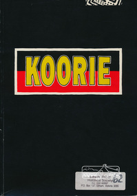
Book, Koorie Heritage Trust, Koorie, 1991c
Oldest culture - Yarra River and Port Phillip - Religion - Serpents - Fire - In 1830 - First contacts - Massacre map - Survival - Identity - Resistance and rights (Pastor Sir Douglas Nicholls) - Land rights - From hand-out to hand-back - Aborigines in war - Sportspeople - Cultural heritage.Paperback; 57, [3] pages : illustrations, maps, ports ; 30 cm.ISBN 0724198105aborigines, social customs, koorie, victoria -
 Ringwood and District Historical Society
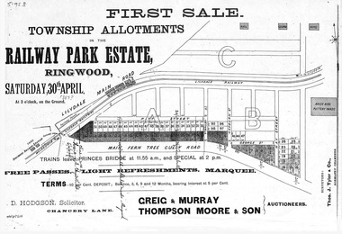
Flyer, Subdivision advertisement - Railway Park Estate, Ringwood, Victoria - circa 1887
Photocopy of advertisement for auction sale of township allotments in Railway Park Estate, Ringwood, on Saturday 30th April (1887?), with terms of sale and location map.Subdivision map includes Pitt Street and Main Ferntree Gully Road (later Bedford Road). (Agents) Greig & Murray, Thompson Moore & Son, Auctioneers. -
 Kew Historical Society Inc
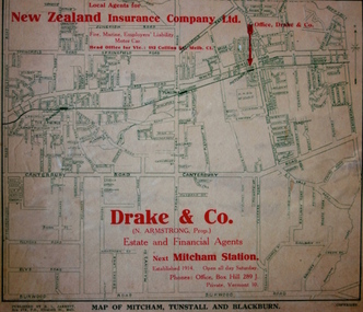
Map - Street Map, R L Jarrett, Map of Mitcham, Tunstall and Blackburn, 1929
Tunstall was originally the name of Nunawading Railway Station. Tunstall opened on 4 June 1888 and was renamed on 1 November 1945. An historically significant advertising map that can be used to ascertain the extent of urban development in 1929 in the areas of Nunawading, Blackburn and Mitcham.A map of Mitcham, Tunstall and Blackburn found on the reverse of a real estate subdivision plan published by R. L. Jarrett of Elizabeth Street. This promotional street map is overprinted with the business address of the sponsors and advertising. Map overlaid in red print: "Drake & Co. / (N. Armstrong, Prop.) / Estate and Financial Agents / next Mitcham Station / Established 1914. Open all day Saturday. / Phones: Office, Box Hill 289 J. / Private, Vermont 10."real estate agents, mitcham, tunstall, blackburn, road maps, drake & co, new zealand insurance co ltd -
 Kew Historical Society Inc
Map, Osboldstone & Co Pty Ltd, Railway and Tramway Map of Melbourne and Suburbs With Tram Timetables, 1917
The Railway and Tramway Map of Melbourne and Suburbs With Tram Timetables lists existing Cable Tram Services before the entire network was electrified. By 1917 the tramways system was divided into regions including: the Melbourne Cable Tram Service; Prahran - Malvern Electric Trams; Hawthorn Electric Trams; Melbourne, Brunswick and Coburg Electric Trams; and Brighton Beach Electric Trams. The old Outer Circle railway line is marked as ending in Deepdene, with the remainder of the line to Fairfield marked as 'Unused'. The Kew tram along High Street in 1917 ended at the Harp Junction. The Kew Spur Line is also marked on the map.The Railway and Tramway Map of Melbourne and Suburbs With Tram Timetables is historically significant as it captures at a point in time, 1917, the development of public transport infrastructure in Melbourne. As such it illustrrates the theme: Connecting Victorians by transport and communications.Printed card-covered pocket sized map that folds out with three horizontal and vertical folds. Colour map, with scale, of the rail and tram networks on one side and sixteen sections of black and white printed text and timetable information on the reverse.railway maps -- melbourne (vic.), tramways maps -- melbourne (vic.), public transport -- melbourne (vic.) -- 1910-1920, cartography -
 Eltham District Historical Society Inc
Folder, Victorian Goldfields Project: Historic gold mining sites in St Andrews mining division, 1999
Heritage site report and gazetteer by David Bannear, head consultant for archealogy for the Department of Natural Resources and Environment. Includes information on the Warrandyte Goldfield and the Caledonia Goldfield, Queenstown (now known as St Andrews), One Tree Hill, Kingston (now known as Panton Hill), Kangaroo Grounds, You You Hill, Kingstown, South Morang, Nillumbik, (now known as Diamond Creek), Steele's Creek, Yarrambet and Kinglake. Photocopy of map headed: Location of mines and reefs from Geological survey of Victoria, Yan Yean with the Diamond Creek prominant on the map. no date35 page report with map and print out of cover letter (email form) from donorcaledonian gold fields, caledonina gold field, david bannear, gold mining, harry gilham collection, queenstown, st andrews, warrandyte goldfield -
 Warrnambool and District Historical Society Inc.
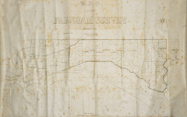
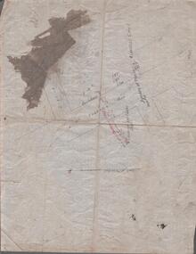
Map - Farnham Survey, 1850s
This is a map of the Farnham Special Survey. In 1843 William Rutledge purchased this Special Survey of 5,120 acres and named it Farnham. This Survey extended from Tower Hill to the Merri River at Dennington. The map appears to date from the 1850s This early map is of considerable significance as it shows details of the Farnham Special Survey. William Rutledge and his survey are important influences in the development of Warrnambool and district with the establishment of settlements at Killarney, Yangery and Tower Hill.A hand drawn map on waxed paper in brown, black and blue ink. It shows Armstrong's Bay, sea, Crown Land , the names of properties and some roads. It includes a compass direction diagram.farnham special survey -
 Ringwood and District Historical Society
Newspaper, Scrapbook Clipping, Library Collection, Ringwood, Victoria, `
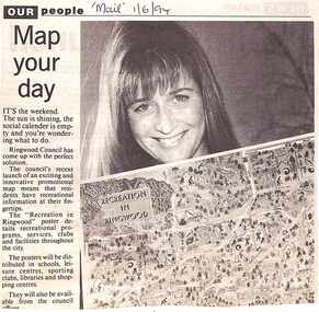
``Newspaper clipping from "The Mail" 1-6-94 OUR people Map your dayThe Ringwood Council's recent launch of an exciting and innovative promotional map means that residents have recreational information at their fingertips. The "Recreation in Ringwood"poster details recreational pograms, services, clubs and facilities throughout the city` -
 National Wool Museum
Photograph
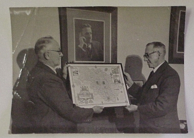
Photograph of Lewis Hirst and Mr Gliddon, holding a framed map of Yorkshire. They are standing in front of a photographic portrait of Godfrey Hirst c1950.Photograph of Lewis Hirst and Mr Gliddon, holding a framed map of Yorkshire. They are standing in front of a photographic portrait of Godfrey Hirst c1950.Godfrey Hirst/ Lewis Hirst/ Mr Gliddon- Foremanweaving mills, godfrey hirst and co. pty ltd excelsior woollen and worsted mills, hirst, mr godfrey hirst, mr lewis -
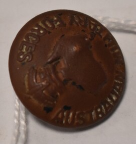 Tatura Irrigation & Wartime Camps Museum
Button - brass, P J King Pty Ltd, 1940's
Found at POW camp 13 site post war by war time camp guardBrass button with Australian Military Forces around front edge, map of Australia in centre with a crown above. Has a brass loop on the back to attach to clothing. Contained in a black material covered display case with gold around edge.on front: Australian Military Forces and a map of Australia and crown. on back P J King Pty Ltd Melbbrass buttons, camp 13, military uniform accessories -
 Federation University Historical Collection
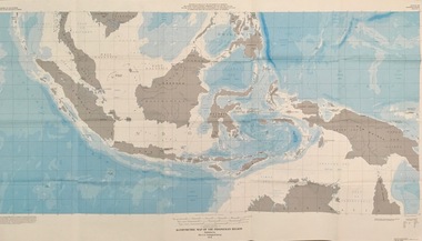
Map - Geological, U.S. Government Printing Office, Bathymetric Map of the Indonesian Region: Folio of the Indonesian Region Map I-875-A, 1974, 1974
Map was prepared on behalf of the Government of Indonesia, The United Nations Economic Commission for Asia and the Far East, the Agency for International Development and the U.S. Department of State in cooperation with the Geological Survey of Indonesia. The area covered shows the islands and seas from Latitude 12 degree North to 16 degrees South and Longitude 90 degrees to 148 degrees. Various water features are also named.Large map showing the Indonesian area - islands and seasLongitude and Latitude are shown. Major / Capitol cities indicated. Names of those responsible for the productionindonesia, united nations economic commission, department of state, geological survey, latitude, longitude, government of indonesia -
 Federation University Historical Collection
Map, Ballaarat Gold Field, 1861, 1861
A party of surveyors camped by Yuille's Swamp (later Lake Wendouree) and surveyed the countryside for a map to be produced by the Geological Survey of Victoria. In November 2004 the Central Highlands Regional Library presented a special edition of 200 copies of the 1861 map reproduced from a copy in their collection. Original 1861 map of Ballarat showing streets and leads. Blue dots indicate gold leads, and red lines indicate auriferous quartz reef and outcrops of quartz veins."Compiled & Drawn from the Survey of Mining Surveyors Davidson, Fitzpatrick and Cowan & the Plans in the Surveyor General's Office by J. Brahe, 21st October 1861. R. Brough Smyth, Secretary for Mines. The Honourable J.B. Humffray, M.L.A. Commr of Mines.”ballarat, map, ballarat east, lake wendouree, survey, mines, robert davidson, ballarat gold field 1861, yuille's swamp, wendouree swamp, little bendigo diggings, gold leads, old post office hill, specimen hill, bakery hill, black hill, dead horse creek, brown hill, pennyweight hill, clayton hill, soldiers hill, golden point, gum tree flat, white flat, poverty hill, chinese village, robert brough smyth, ballarat map 1861, ballaarat vineyard, dead horse gully, deadhorse creek, invermay, black hill flat, gaelic church, police reserve, magpie range, dalton's flat, caadian lead, rifle butts, powder magazine, bathing house, government camp, gold office, chinese, llanberrris, victoria theatre, charlie napier hotel, united states hotel, grape's hoel, clayton's hill, cattleyard hill, free trade hotel, esmond lead, bakery hill, black hill lead, juvenile reformatory, ballarat orphanage, lady barkly lead, triffet's slaughter yard, little bendigo, melbourne road, t. cowan, thomas cowan -
Whitehorse Historical Society Inc.
Pamphlet, Bellbird Dell
A pamphlet about a municipal reserve - Bellbird Dell, with a list of names of the Management Committee.A pamphlet about a municipal reserve - Bellbird Dell, with a list of names of the Management Committee. Also states they are looking for helpers for regular working bees. Includes map of reserve.A pamphlet about a municipal reserve - Bellbird Dell, with a list of names of the Management Committee.local government, city of nunawading, bellbird dell, vermont -
 Bendigo Historical Society Inc.
Map - MINING REPORTS - MAP OF COLLMANN AND TACCHI SHAFT
Collman and Tacchi shaft drawn on map corner of Dowding Street and Mt. Korong Road, California Gully, Bendigo. Mt Korong Road later became Eaglehawk Road. Hand drawn map showing the Collmann and Tacchi Shaft with No 17 Crosscut with the distances in feet and inches and the compass bearing of each leg. It is beside Mt Korong Road, near Dowding Street. Some boundary lines are drawn. Also on the map is Lansell's C and T across the road.map, bendigo, goldfields, mining reports, map of collmann and tachi shaft, collmann and tacchi shaft, lansell's c and t -
Whitehorse Historical Society Inc.
Map, Shires of Boroondara, Nunawading, C1856
... Maps ...Photocopy of part of very early map covering parts of Boroondara and Nunawading.Photocopy of part of very early map covering parts of Boroondara and Nunawading. Marks old tracks on lines of Whitehorse and Canterbury Roads.Photocopy of part of very early map covering parts of Boroondara and Nunawading.maps, shire of nunawading, shire of boroondara, barkers track, deep creek, nunawading -
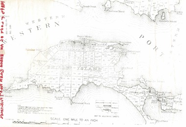 Phillip Island and District Historical Society Inc.
Document, 1869 Crown Land sale and map of Phillip Island showing allotments
... maps ...Anderson and McHaffie were prominent early settlers of Phillip Island. These documents were from the estate of Stan Mcfee snr. Listings of auctions at Gemmell, Tuckett & Co., Collins Street, Melbourne 12 February, 1869HistoricalCopy of map showing allotments for 1869 land sale and hand written note showing allotments, area, prices for purchases of Robert Anderson and notes on McHaffie land.robert anderson, glen isla, john mchaffie, maps, land sales -
 Shepparton RSL Sub Branch
Escape Map Cloth, July 1944
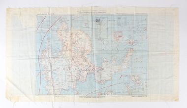
Silk escape map issued to Allied Airmen during World War 11 for the Pacific campaignsA silk escape map including detail of tides and winds was relevant to air force personnel in Pacific regions during WW2. Coloured Cloth Escape Map of Side A : No. C44 North Borneo Side B: No C43 Mindanao Island SCALE: 1:1,000,000; Wind and Current markings; AAF Cloth Cart- Philippine Series Prepared under the direction of the Commanding General, Army Air Forces, by the aeronautical Chart Service, Washington DC July 1944world war ii, second world war, silk escape map, pacific conflict -
 Doncaster RSL Sub Branch
Papers Bomber D4854
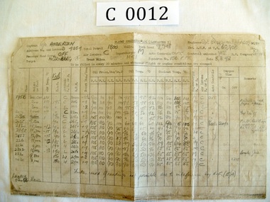
Maps 11-02-43 Wilhelmshaven,8-03-43 Nurnburg 27-03-43 Berlin, logs Nurnburg and Berlin. Lancaster Squadron 156 Pathfinder RAF Warboys Huntingdonshire.Sgt. Patrick Brougham(Faddy) Commenced operations Feb 1943 killed on operation to Skoda16-04-1943 aged 18 1/2, buried with his six companions Brimond near Rheims France.Maps three Missions and Engineers log for two missions -
 Bendigo Military Museum
Plan - MAP, TOURIST, L Joly, A Maunier, WWI
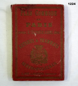
The map belonged to Jack Grinton No 1043 38th Batt AIF. At Wars end extensive leave was granted, Jack journeyed to Paris, Nice, Monte Carlo taking many photos. Part of the Grinton collection which included hundreds of negatives and developed photos that he took during the War. Refer Cat No 1280 for service details. Refer 1317P, 1320P.Map of Paris. Red cardboard or paper hardcover, new edition guide of metropolitan Paris (ministries, tramways, monuments), Index in front, folded paper map attached to back cover. "Plan commode de Paris avec l'itineraire des autobus & tramways metropolitan"documents-maps, french -
 Warrnambool and District Historical Society Inc.
Maps (2), 1 Kapong .2 Hawkesdale, 1 1913 .2 1942
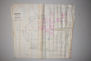
These two maps of the Kapong/ Hawkesdale area in Victoria show the original lands that belonged to the pioneer settler, Charles Hamilton MacKnight and the handwritten annotations that show the subsequent owners of these lands. Charles Hamilton Macknight (1819-1873) came to Australia from Scotland in 1841 and in 1842, with partners, James Irvine and William Campbell, established the property of Dunmore in Broadwater (24 kilometres from Hawkesdale). He was a prominent breeder of sheep, cattle and horses. Sections of his lands were acquired by the Baulch family and these maps were acquired from a member of the Baulch family, with Stanley Baulch being the possible annotator of the Kapong map. These maps are of interest as they show the properties that belonged to the pioneer settler, Charles Hamilton MacKnight and the subsequent division of these lands, some of these passing into the hands of the Baulch family. As the Kapong map also shows other original landowners, it will be a useful tool for researchers..1 This is a map of Kapong in the County of Villiers. It is on a rectangular-shaped piece of linen-backed paper with black printing and some handwritten annotations in red ink. It is crumpled at the edges. .2 This is a rectangular-shaped piece of paper showing a map of the Hawkesdale area. The printed material is in grid form in black, green and red. At the left bottom edge it has a mauve stamp. kapong, victoria, hawkesdale, victoria, dunmore estate, victoria, charles hamilton macknight, baulch family, western victoria, history of warrnambool -
 Warrnambool and District Historical Society Inc.
Map, Soil conservation authority:plan of high water marks at Lady Bay Warrnambool, 1984
This map documents the changing state of Lady Bay from around 1870 until 1976. It depicts the changing high water mark over that period and the main outlet of the Merri River in 1872 and 1976.This map provides a useful and significant insight into the ever changing face of Lady Bay from the 1870’s through to 1980’s. Cream paper map drawn with black ink showing Lady Bay and South Warrnambool section of Warrnambool. In lower RH corner Soil conservation AuthorityPlan of High water marks at Lady Bay Warrnambool. Drawn P.D. 19.1/84. Scale 1:3600. Written on back in black pencil: Lady Bay Historical HWM lady bay map, merri river 1872- 1976, merri river 1872- 1976, history of warrnambool -
 Kew Historical Society Inc
Map, Department of Lands & Survey, Map of Melbourne & Suburbs, 1899
The Melbourne & Metropolitan Board of Works was established in 1891 to oversee the introduction of a sewerage and water reticulation system in Melbourne and its suburbs. This complementary map was produced by the Department of Crown Lands & Survey [Victoria] in the same decade showing the distribution of water in Melbourne for use by fire brigades. While by 1910, there were 123,227 connections to Melbourne's water supply system, it is unclear in this 1899 map whether water was supplied to all built structures in the defined areas or only to fire hydrants and stand pipes, as we know that the first connection of a building to the sewerage system in Kew only occurred in 1904.Map accompanying report on fire protection of Melbourne showing those areas supplied with water in colour.water reticulation -- melbourne (vic.), department of lands & survey -- historic maps, fire brigades -- melbourne (vic.), cartography