Showing 3171 items matching "mr white"
-
 Kiewa Valley Historical Society
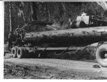
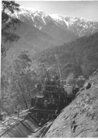
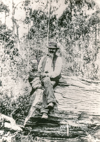
Photograph, logging at McKay Creek, Logging at McKay Creek, 1949/50
This photo was most likely taken at the site of the proposed McKay Creek Power Station. Excavation of this site was commenced in 1951 but an access road (a rough, narrow track) was put it in 1948 and widened in 1954. The State Electricity Commission would have milled logs from this area at their mill at Howman's Gap. The timber was used for building of housing and camps and provided a much needed resource as there was a general shortage of this commodity. The power station was relocated underground owing to repeated problems with landslides in the area. Restricted financial resources and the repositioning of the power station retarded construction activities and it was not completed until early 1961. An historical pictorial record of the type of machinery used in the 1950's - logging truck with bogie attached, the bull dozer and winch for hauling logs to the truck and note the lack of protective clothing!Black and white photograph showing a logging truck, bogie and bull dozer with winch for hauling the logs to the truck. Two men are on the truck, a driver on the bull dozer and a large log on the bogie. Hand written on the back of photo "Logging at McKay Creek".logging, mckay creek, timber, machinery -
 Kiewa Valley Historical Society
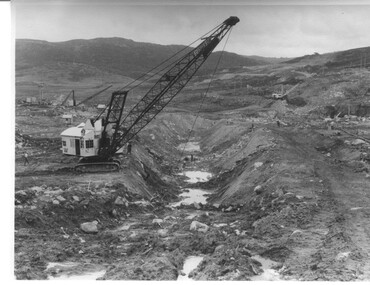
Photograph Rocky Valley Dam Excavations, Rocky Valley Dam Wall Excavation, c1947-48
Work commenced at Rocky Valley Dam site in early 1947 and proceeded until May. Resumed work in October after the winter and a camp for the accommodation of workmen was commenced at this time. Work continued in 1948 with the establishment of work facilities, including the erection of two large excavators. At the dam site the river was diverted through a temporary pipeline. Work proceeded in the summer months with the placing of concrete in the foundations and earth and rock fill for the construction of the wall. Rocky Valley and associated spillway and outlet works were completed in March, 1959. A very good representation of the type of machinery available in the 1940's used for excavation of the dam and the construction of the dam wall.Black and white photograph of Rocky Valley Dam wall under construction. There are at least three cranes plus workmen in the photo. This is taken from the Heathey's Spur side of the dam wall looking back toward Sun Valley.Hand written on back of photograph "Rocky Valley Dam Wall Excavation" in blue ink.rocky valley, dam, wall, machinery -
 Kiewa Valley Historical Society
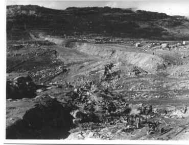
Photograph of Rocky Valley, Rocky Valley showing Dam Excavation, c1948-1951
This photograph was taken during construction of the Rocky Valley Dam and wall. Work was commenced in early 1947 but had to be suspended during winter and then resumed in October. Work continued in 1948 with the establishment of work facilities and, at the dam site, the river was diverted through a temporary pipeline. Rocky Valley and associated spillway and outlet works were completed in 1959.A pictorial record of the construction of the rock and earth filled dam wall at Rocky Valley. Shows the extent of the project undertaken and the fact that a lot of the work was done manually by pick and shovel - note the workmen using picks and sledge hammers on the lower half of the photo.A black and white photograph showing the excavation of the dam at Rocky Valley looking towards Heathey's SpurHand written on the back of photograph in blue ink "Rocky Valley showing dam excavation" rocky valley, dam, wall, picks, sledge hammers -
 Kiewa Valley Historical Society
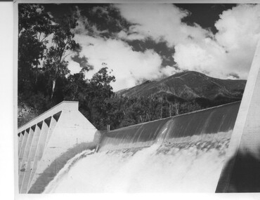
Photograph of Lake Guy Dam, Spillway, Lake Guy Dam, c1945
In December 1939 the excavation of the diversion tunnel at the site of Junction (Lake Guy) Dam was commenced and finished in February, 1940.This allowed the stream to be diverted to facilitate the dam wall construction. This is a 'slab and buttress' dam. It is framed with timber and concrete then poured into the structure. A contract was let to Lewis Construction Co. for the construction of the dam, and the first batch of concrete was placed in September, 1940. Industrial trouble caused some delays but there was also slow progress on the part of the contractor and the work was taken over by the S.E.C., terminating the contract. The dam was completed in March, 1944. The lake is named after Mr. L.T. Guy who was the Resident Engineer, in charge of construction work and associated activities on the Kiewa area, from 1939 until November 1946. An historical pictorial record taken for the State Electricity Commission of Junction Dam (Lake Guy) on spill. Mt. Arthur is in the background and there is still evidence of the destruction of trees from the 1939 bushfires. Black and white photograph of Lake Guy Dam . The dam is spilling and Mt. Arthur is in the background. Hand written on back of photograph in blue ink " Lake Guy Dam".dam, lake, water, mr. l.t.guy -
 Kiewa Valley Historical Society
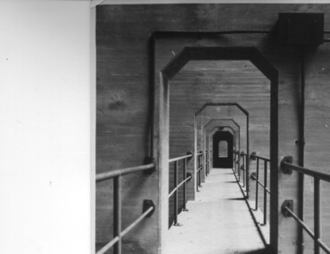
Photograph of Lake Guy Dam, Walkway, Inside Lake Guy Dam, c 1945
Lake Guy Dam is a 'slab and buttress' type wall. A timber frame is built and then filled with concrete. The first batch of concrete was placed in September, 1940. By June, 1941 the buttresses were finished to a height safe from floods and in October of that year a flood of 2,800 cusecs occurred but with only slight damage to the installations. Industrial trouble caused some delays but there was also slow progress on the part of the contractor and the work was taken over by the S.E.C., terminating the contract. The dam was completed in March, 1944. A walkway was made through the dam wall. Lake Guy was named after Mr. L.T. Guy who was the Resident engineer, in charge of construction work and associated activities on the Kiewa Area from 1939 to November 1946.Shows the walkway placed as part of the Lake Guy (Junction) Dam wall. A very good pictorial reference for the future.Black and white photograph of the walkway through Lake Guy (Junction) Dam wall.Handwritten in blue ink on back of photograph "Inside Lake Guy Dam". slab, buttress, dam, mr. l.t. guy -
 Kiewa Valley Historical Society
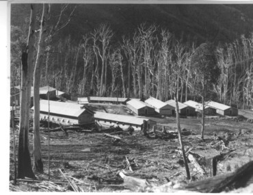
Photograph of Howmans Dam Camp, Howmans Dam Camp, circa 1948
Howman's Gap camp was erected in 1948. The proposed dam to be built at this site was postponed in 1954 because of financial restraints imposed by the government at this time. It was to have supplied water for No. 2 Power Station at the Junction of the Pretty Valley and Rocky Valley branches of the East Kiewa River. This power station was not constructed until 2008 - 2010 and now gets it water from McKay Creek Power Station. The site of this camp is now occupied by the Howman's Gap Alpine Centre. Some of the original buildings still remain. An excellent photographic record of the type of buildings and size of the camp for accommodation of workmen during construction of the Kiewa Hydro Electric Scheme.Black and white photograph of the buildings erected at Howmans Dam site as accommodation for workmen.Handwritten in blue ink on the back of photograph "Howmans Dam Camp"howman's gap, camp, water, dam -
 Kiewa Valley Historical Society
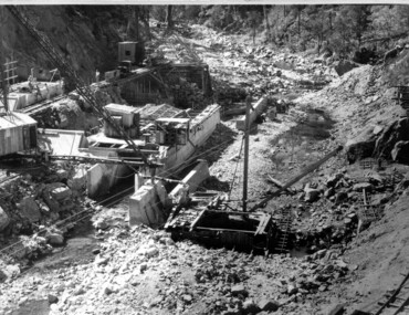
Photograph of Clover Dam foundations, Clover Dam Foundations, 1949
Stripping of the foundations commenced in 1948 and the first concrete in the dam was poured in May, 1949. With the suspension for the winter months of work on the High Plains, it was possible to increase the number of men, and work then proceeded at a steady pace for the remainder of the year. Some interruption was caused by a flood in September, which over topped the rockfill coffer dam. By the end of 1950 17,000 yards of material had been excavated from the foundations and 4,000 cubic yard of concrete placed. Work at Clover Dam was completed in 1953, but two bays were left open for flood emergency. The pondage was filled on the 16th August, 1954. A pictorial record of the placing of concrete foundations of Clover Dam and also shows the methods of construction used at this site in 1949.Black and white photograph taken during the construction of Clover Dam. Shows early stages of the concrete foundations, cranes and the railway line which was constructed to bring materials to the site. Handwritten in blue ink of back of photograph "Clover Dam Foundations"dam, foundations, concrete, construction -
 Kiewa Valley Historical Society
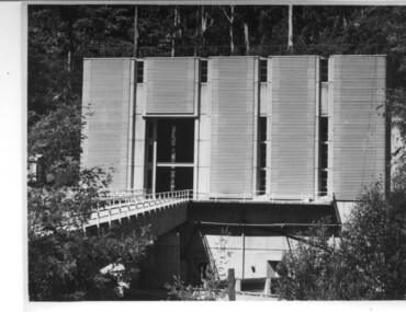
Photograph of Clover Power Station, No. 3 Power Station, after May 1944
In July, 1941 work commenced on the site of the power station with the building of a coffer dam and excavation for the power station building and machine foundations followed. Work proceeded, and the access bridge, transformer foundations and transfer track were completed in April, 1943 and the power station building in May, 1943. Installation of the machines was then proceeded with and No. 1 machine was run for the first time in June 1944. No. 2 machine was completed in April, 1944 and placed in service in May.A pictorial record for the State Electricity Commission of the first Power Station commissioned in the Kiewa Hydro Electric Scheme.Black and white photograph of the bridge and entrance to No. 3 Power Station (Clover Power Station).Handwritten on back of photograph in blue ink "No. 3 Power Station".clover, power station, machine, kiewa scheme -
 Kiewa Valley Historical Society
Photograph of Bogong Creek Raceline, Bogong Creek Raceline, circa 1951
A start on the construction of Bogong Creek race line was made at the commencement of winter in 1948. Work proceeded in the following years when work on the High Plains was not practicable. In January, 1951 the special trimming machine, the special slip form and concrete mixing and placing equipment was put into service. A shortage of cement caused some delays as well as a sudden financial recession. The race line was completed and put into service in 1952. An historical record showing the machinery used , the number of workers needed at any one time ( about 16 in this photo) and the mountainous terrain of the area. Black and white photograph taken during construction of Bogong Creek Raceline, showing the type of machine used for the formation of the concrete lining, the mountainous terrain, a number of workmen and a snow capped Mt. Bogong in the backgroundHandwritten on the back of photograph in black ink "Bogong Creek race line".race line, cement, machinery, bogong -
 Kiewa Valley Historical Society
Photograph of Pretty Valley Camp, Pretty Valley Camp, circa 1948
At the Pretty Valley Dam site erection of staff quarters was completed in April, 1947 and accommodation for workmen commenced in 1948 but suspended on 11th May for winter and resumed on 9th November. Construction of this camp was completed in 1949. A large dam was proposed at this site but was never constructed. Instead a small diversion dam was built which diverts water either to Rocky Valley Dam or to McKay Creek Power Station.An historical record of the type of accommodation provided for workmen during the construction of the Kiewa Hydro Scheme during the 1940's/50'sBlack and white photograph of Pretty Valley Camp showing general terrain and the huts built to accommodate workmen employed on the Kiewa Hydro Electric Scheme.pretty valley, dam, water, workmen, camp -
 Kiewa Valley Historical Society
Photograph of Pretty Valley Workers Camp*, Pretty Valley Camp, circa 1949
Erection of staff quarters at Pretty Valley was completed in April, 1947 and accommodation for construction workers commenced in 1948 but suspended on 11th May for winter and resumed on 9th November. Construction of this camp was completed in 1949. A large dam was proposed at this site but was never constructed. Instead a small diversion dam was built which diverts water either to Rocky Valley Dam or to McKay Creek Power Station.An historical record of the type of accommodation provided for workmen during the construction of the Kiewa Hydro Scheme during the 1940's/50's.A black and white photograph of Pretty Valley Camp, c 1949. Dead trees are in the foreground, on both the left and right side of the photograph and a small snow gum is evident. There are camp huts and a much larger building behind these, possibly a workshop, and power poles are evident bringing electricity to the site.Handwritten in blue ink on back of photograph "Pretty Valley Camp. 5600 ft. above sea level".pretty valley, dam, water, workmen, camp -
 Kiewa Valley Historical Society
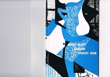
Book - Reference Cooking, Mount Beauty Souvenir Cookery Book x2, Circa 1962
This cookery book was printed in the early 1960s for the purpose of obtaining the necessary funds for the construction of the Mount Beauty swimming pool. The advertisements within this book covers local traders of this time frame, for example, the Bogong Hotel which is no longer operational. the culinary measurements are in Imperial measures(pounds and ounces). The book has sections for continental dishes and sweets (Australian flavour), special dishes for Lent, cakes (farmhouse fruit cake), jams, marmalades (home made), marrow and apple chutney. Some of these recipes are early 20th Century related and in the 2000s are not sought after. The food "take away" lifestyle has been responsible for the demise of a lot of the recipes in this book. The swing away from home grown produce has been not only a lifestyle change but also the faster pace of living in rural areas. The specialisation and redefined development of the local produce store (previously provided everything the rural shopper needed) was a forced move due to larger and cheaper city born fresh food supermarkets. Although there are still some local produce store within the region these will in time vanish. This cookery book was produced just after Mount Beauty was released from an SEC "closed" community in 1961(see KVHS 0134) and the town then had to fend for itself. This book was compiled and produced because the town needed a swimming pool (which possible would have been provided had the SEC still been responsible). The book demonstrates the strong rural psyche of rallying together for the good of all and united for something which would be of benefit to all. The period 1961 to the 1970s was one of great change for Mount Beauty. The SEC protective cage was a blessing for some but a goal for others. The independence that was gained after the SEC left provided for a drastic "make over" in regards to the facilities provided for the "locals" and that for the tourists. An increase in tourist related industries such as snow skiing in winter, hang gliding and gliding, mountain bike rallies, bush walking and horse riding, all of which have supply outlets in the town, has provided a more cosmopolitan atmosphere. These activities and the greater interaction with populations outside of the region has reduced the "hermit" type feel of the town psyche.This recipe book consists of eighty nine pages in black and white print. It contains black and white sketches, recipes of local domestic cooks and advertisements covering local traders. The cover is approximately 280 g/m2 in weight and the pages are at 90 g/m2 in weight. The cover has a design in the style of Abstract Expressionism (period 1950-1960s) of identifiable (clock,jug,fruit,window) and abstract objects in tints of blue and shades of black. This was designed by Cheryl Ryder of the Mount Beauty High School, under supervision of Mr I Baker (Art Teacher)On the foreword(page two and page three) "Mt. Beauty Souvenir Cookery Book First Edition" . This foreword was presented by Rosa Kinnear, President, Ladies' Auxiliary 2nd copy - no inscriptionrecipe, cooking, food, domestic, kitchen, local history, comfort food, pioneer cleaning methods -
 Eltham District Historical Society Inc
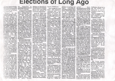
Photocopy of newsclipping, Elections of long ago
Article in unknown newspaper of a reprint of an article: Elections of Long Ago, in Nhill Free Press, 1938. The article discusses William Hall Irvine's election In 1894 when he stood for the rural Legislative Assembly seat of Lowan. Irvine achieved a surprise victory .... Mr Irvine became a Premier of Victoria and Chief Justice and lived the later part of his life at Killeavey, Eltham.A4 black and white photocopysir william irvine -
 Eltham District Historical Society Inc
Photograph, Entrance to Shire of Eltham Memorial Park, Garden Hill, Eltham-Yarra Glen Road, Kangaroo Ground, c.1923
View to south-east from Shire of Eltham Soldiers' Memorial Park showing the carriageway from the road to top of Memorial Park. Accompanying notes state that the entry gate was put in place in May 1921. Eltham and Whittlesea Shire Advertiser and Diamond Creek Valley Advocate Fri 21 May 1920 p 2 reported: Kangaroo Ground Memorial Park "It was decided to arrange for a working bee on Saturday, 29th inst., for the purpose of forming and gravelling the track leading to the Park, and of carrying out other necessary works." A history summary of the Shire of Eltham Soldiers’ Memorial Park • The summit at Garden Hill was a popular tourist lookout and picnic spot from the 1880s. Virtually the entire Shire of Eltham and beyond could be viewed from this location. • A local farmer, Mr Walter A. D. Wippell is credited as being the first to propose the idea of a war memorial park and offered £50 towards the purchase of the land. • The earliest public reference to this project is to be found in the local Advertiser newspaper edition of August 9th, 1918. A report of the August Council meeting records the Eltham Shire President, Cr. Robert White, saying: "some time back it was proposed that the Council obtain and place on an Honour Board in the Council Chamber [at Kangaroo Ground] containing names of the lads who had enlisted. Just recently however, it had been suggested that a more fitting memorial would be the obtaining of a piece of land on the summit of Garden Hill, Kangaroo Ground, and the formation of a memorial park in which a monument could be erected to represent the whole of Shire. If a couple of acres could be obtained a gentleman had promised to donate 50 pounds, and another one would fence it, and other contributions, he was sure, could be obtained." • Councillors were favourable of the proposal and the President, Shire Secretary and Shire Engineer were deputised to wait on Messrs Mess Bros. (the owners of the Garden Hill farm) and ascertain if they would gratuitously give the land. The Mess Bros. land adjoined the farm/stud of Mrs Fanny White (Cr Robert White’s mother), daughter of Andrew Harkness who established their property on Garden Hill around 1846. • Access to the land came in February 1919 when several Councillors and the Shire Engineer surveyed the actual two acres of '5 chains along the road and 4 chains deep'. The Engineer volunteered his services free to do this task. The Mess brothers however demanded £100 per acre but eventually agreed to take £50 per acre. • Entry from the Kangaroo Ground-Yarra Glen road was seen to be a problem and Mrs. White, who owned the land beside the park, was asked to donated a triangle of her property to allow this access. • By September 1919 returned soldiers were employed by the Shire and volunteers were called to clear the hilltop by ploughing up the rocks and clearing the area, the fencing was put into place and in May 1921 the Council erected three gates, within an archway, at the entrance to the drive and pathway to the summit. • Public subscriptions were sought through the Advertiser newspaper to beautify the site. The views of the Curator of the Melbourne Botanical Gardens were sought as to the ‘class of ornamental trees most suitable for planting in the Park area”. • The Memorial Park or Shire of Eltham Soldiers’ Memorial Park was officially opened by Mr. W.H. Everard, M.L.A., 3 September 1921. • In 1922 plans were made to place a War Memorial in the Park. Funds were donated by the Council of £250 and a challenge to the community, to match this money with contributions was met. • On Anzac Day 1923, 1,000 people gathered on the summit in the park for a memorial service. A much smaller group of about 50 people gathered around a newly constructed cairn and flagstaff in the afternoon of Anzac Day 1924 amidst rain and a squally southerly wind, the morning service being cancelled. • A meeting for those interested in establishing a War Memorial monument within the park was held in January 1924 and the Eltham Shire War Memorial League was formed and a design competition decided upon. • The Shire of Eltham War Memorial tower was built in 1926 at a cost of £1,023 and 5 shillings with locally quarried stone donated by Dr Ethel and Professor William Osborne. It was formally known as the ‘Shire of Eltham War Memorial’ and was unveiled on 11 November 1926. The large bronze inscription above the entrance to the tower states: SHIRE OF ELTHAM WAR MEMORIAL THESE MEN DIED FOR THEIR COUNTRY 1914 IN REMEMBRANCE THIS TOWER WAS BUILT 1918 • The Caretaker’s hut was built in 1927 with left over from the tower construction. • A returned soldier was appointed to act as caretaker for the memorials. Tiny Carrol, a huge man, was the first caretaker and lived in the stone hut. There was a push to have alterations made at one stage to provide additional rooms for a married caretaker but was rejected. • A new Caretaker Cottage was built in 1951 at a cost £2,500. The cottage had been subjected to raids by thieves three times during construction until a guard from the Returned Servicemen’s League was posted until its opening. • The War Memorial tower was re-dedicated by Sir Dallas Brooks on 8 November 1951, unveiling new bronze plaques containing the names of those who fell during the Second World War. Sir Dallas also officiated the opening of the new Caretaker’s Cottage. • A toilet block was built in 1965. • A further dedication of the Shire of Eltham War Memorial tower took place 11 November 2001 to recognise the men who fell in subsequent campaigns up to and including Vietnam. • Four land titles are involved: o The purchase of the two acres from owners Ruth Gosling, Alexander Mess, James Johnson Mess and Joseph Mess is recorded in two actions, the first being the payment of £100 for the two acres, the second showing that the Shire of Eltham did not get a transfer of title until 14th January 1952. o The access land donated by Mrs. Fanny White is dated 26 February 1924. A further need to widen the entry came after the deepening of the road cutting and another land donation was given by Sir Herbert Gepp, title dated 15th May 1952. This would have been about the time he sold off the former White ‘Garden Hill’ property. o The land reserve to increase the area and possibly allow a circuit road to be put in place on the western side of the park was purchased by the Shire of Eltham, title dated 16th February 1973. Rare photograph of the entrance to the Shire's Memorial Park during early stages of development prior to the erection of the Shire of Eltham War MemorialSepia photograph printed with white border with slight crack lower left hand corner and three significant vertical cracks fanning from lower centre edge to upper edge Digitally enhanced version to minimise impact of crackseltham-yarra glen road, entrance gate, garden hill, kangaroo ground, shire of eltham memorial park, shire of eltham war memorial, kangaroo ground war memorial park -
 Eltham District Historical Society Inc
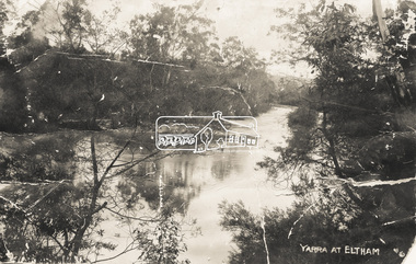
Photograph - Photo postcard, J.H. Clark, Yarra at Eltham, c.1910
This card depicts the Yarra River at Eltham circa 1910. It was addressed to "Mr J. L. Brown, "Elthamville", Tinning Street, Brunswick" most probably from an extended family member. From the same collection as accession no 00779, (Pond near Eltham Park) and no. 00780 (Eltham, J.H. Clark Photo - dated 20 May 1911). Sending postcards to family and friends including short messages was a common form of communication in the early 20th century. Photographer: J.H. Clark John Henry Clark was the youngest of three boys born to William Henry Clark (1823-1877) and Maria White (1843-1914). He and his brothers, William Charles Clark (1872-1945), Clement Kent Clark (1874-1912) operated a photography business (Clark Bros.) from 25 Thomas Street, Windsor near Prahran during the period c.1894 to 1914. Following death of Clement in September 1912 and their mother in 1914, the Clark Bros business appears to have dissolved, the premises demolished, and a new house was under construction in 1915. John set up business independently in 1914 operating out of 29 Moor Street, Fitzroy where he is registered in the 1914 and 1915 Electoral Rolls. By 1916 John had relocated to Eltham where he continued his practice as a photographer and took many of the early images around the district of Little Eltham. Around 1930 John changed professions and opened a small cobbler's shop in 1931 near the pond opposite Dalton Street adjacent to the Jarrold family cottage. He never married and continued his profession as a bootmaker from this little shop, maintaining a close relationship with Mrs Jarrold for the rest of their lives. His bootmaker shop remains today beside the Whitecloud cottage and is one of only three remaining shops in the area from the early 20th century. There are a couple of images of Eltham taken by Clark Bros. in the Eltham District Historical Society collection, one such example being Hunniford’s Post Office with Miss Anne Hunniford out front (EDHS_00140 - marked on the back of the print, Clark Bros., 25 Thomas St. Windsor), which would date this image between c.1894 and 1914. Other early images of Eltham taken by John Henry Clark are marked on the face “J. H. Clark Photo” and it is assumed these are dated between 1914 and 1930. It is noted that the Grant of Probate for John H Clark of Eltham South dated 5 April !957 (513/387) records his occupation as "X Photographer".Sending postcards to family and friends including short messages was a common form of communication in the early 20th century.Postcard in very poor condition which has been removed from an album. Glue residue and album page adhering preventing information being readFront: Yarra at Elthameltham, yarra river, brown family, j.h. clark photo -
 Eltham District Historical Society Inc
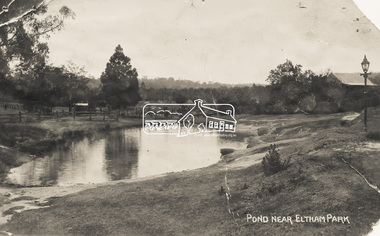
Photograph - Photo Postcard, Pond near Eltham Park, c.1910
This card depicts the pond near Eltham Park (later Eltham Lower Park) circa 1910. The view is taken from Maria Street (Main Road) opposite Dalton Street looking northwest across the Dalton Street road extension reserve (now Wingrove Park Trail) and Jarrold farm. A haystack is visible. Also visible is a gas streetlight and White Cloud cottage which belonged to the Jarrold family From the same collection as accession no. 00778, (Yarra at Eltham) - sent from Eltham and addressed to "Mr J. L. Brown, "Elthamville", Tinning Street, Brunswick" "with love from Nellie" who was most probably a member of the extended Brown family, and no. 00780 (Eltham, J.H. Clark Photo - dated 20 May 1911). Sending postcards to family and friends including short messages was a common form of communication in the early 20th century. Part of a slide show presentation "Bridges & Waterways of the Shire" by Russell Yeoman to the 13 September 1989 Society meeting. The presentation included slides of historic photos from the Shire of Eltham Pioneers collections as well as several recent views.Sending postcards to family and friends including short messages was a common form of communication in the early 20th century.Sepia postcard in very poor condition which has been removed from an album. Glue residue and album page adhering preventing information being readFront: Pond near Eltham Parkpostcard, eltham, pond, dalton street, duck pond, eltham park, elthamville, gas lamp, haystack, jarrold cottage, jarrold property, main road, maria street, white cloud cottage, wingrove park trail -
 Eltham District Historical Society Inc
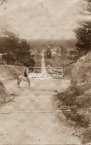
Photograph - Photo postcard, J.H. Clark, Eltham, looking down Bridge Street near intersection with Main Road, c.1910
This postcard depicts the view down Bridge Street from east of Maria Street (Main Road) circa 1910. A man on a horse stands in the foreground. J.H. Clark Photo is stated under the title. From the same collection as accession no. 00778, (Yarra at Eltham) - sent from Eltham and addressed to "Mr J. L. Brown, "Elthamville", Tinning Street, Brunswick" "with love from Nellie" who was most probably a member of the extended Brown family, and no. 00779 (Pond near Eltham Park). "Dear John, As you see " can be ascertained on the reverse of this card. Sending postcards to family and friends including short messages was a common form of communication in the early 20th century. Photographer: J.H. Clark John Henry Clark was the youngest of three boys born to William Henry Clark (1823-1877) and Maria White (1843-1914). He and his brothers, William Charles Clark (1872-1945), Clement Kent Clark (1874-1912) operated a photography business (Clark Bros.) from 25 Thomas Street, Windsor near Prahran during the period c.1894 to 1914. Following death of Clement in September 1912 and their mother in 1914, the Clark Bros business appears to have dissolved, the premises demolished, and a new house was under construction in 1915. John set up business independently in 1914 operating out of 29 Moor Street, Fitzroy where he is registered in the 1914 and 1915 Electoral Rolls. By 1916 John had relocated to Eltham where he continued his practice as a photographer and took many of the early images around the district of Little Eltham. Around 1930 John changed professions and opened a small cobbler's shop in 1931 near the pond opposite Dalton Street adjacent to the Jarrold family cottage. He never married and continued his profession as a bootmaker from this little shop, maintaining a close relationship with Mrs Jarrold for the rest of their lives. His bootmaker shop remains today beside the Whitecloud cottage and is one of only three remaining shops in the area from the early 20th century. There are a couple of images of Eltham taken by Clark Bros. in the Eltham District Historical Society collection, one such example being Hunniford’s Post Office with Miss Anne Hunniford out front (EDHS_00140 - marked on the back of the print, Clark Bros., 25 Thomas St. Windsor), which would date this image between c.1894 and 1914. Other early images of Eltham taken by John Henry Clark are marked on the face “J. H. Clark Photo” and it is assumed these are dated between 1914 and 1930. It is noted that the Grant of Probate for John H Clark of Eltham South dated 5 April !957 (513/387) records his occupation as "X Photographer".Sending postcards to family and friends including short messages was a common form of communication in the early 20th century. Original sepia photo postcard hand dated 20 May 1911 in very poor condition which has been removed from an album. Glue residue and album page adhering preventing information being read Eltham J.H. Clark Photoeltham, bridge street, j.h. clark photo, main road, maria street, horse rider -
 Eltham District Historical Society Inc
Photograph, Main Road, Eltham South, near Eltham Park, flooded by the Diamond Creek, 30 Nov. 1934
Near Eltham Park (now known as Eltham Lower Park), floodwaters from the Diamond Creek cut off the Main road into Eltham at Bremner’s Flats (present day Wingrove Park). In the distance, left of centre, is Mr. Montieth's Ford Wagonette stranded in the floodwater near Wingrove Cottage. “On the Lower Eltham Reserve the water was nearly five feet deep across the reserve and over a mile along the road. All the week-end shops are surrounded. For over 40 years flood waters have not reached this unprecedented level.” - Advertiser, Friday November 30, 1934, p7 "Whilst we were at the shop a "tidal" wave occured . There used to be a Mr. Monteith who ran a Model T Ford bus from the Eltham Railway Station down the main street. The bus would hold seven, six seated in the back, 3 aside a seventh standing on the step on the middle of the back hanging on to two small hand rails. The bus was caught by the flood and was abandoned not far from our shop in the paddocks towards the Higher Elementary School. It was there for days and after the flood waters receded, Mr. Monteith, after removing all the mud and debris gave the engine one turn with the handle and it started first time! So the story goes! " (Doug Orford Reminiscences, 2004) The 1934 flood of the Diamond Creek and Yarra River is the highest recorded flooding in the district and set the standard for the current planning flood plain level.Black and white photograph showing the floodwater from Diamond Creek across Main Road in 1934. Left of centre shows Mr. Montieth's Ford Wagonette in the floodwater in the distancefloods, main road, eltham south, diamond creek (creek), wingrove cottage, wingrove park, bus services, bremner's flat, eltham park, ford wagonette, mr. montieth, floodwater, reminscences -
 Eltham District Historical Society Inc
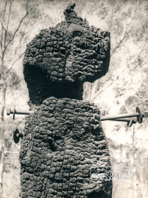
Photograph, George W. Bell, Diamond Creek, 1969, 1969
Canberra Times (ACT : 1926 - 1995), Thursday 9 January 1969, page 1 A day of century heat, 13 KILLED IN VICTORIAN FIRES ...About thirty houses and a public hall were destroyed by fire in the township of Diamond Creek. The group officer of the Diamond Creek Fire Brigade, Mr Tom Harrington, said tonight that he thought it was a "miracle" that no-one lost their lives in the fires. A relief centre for the homeless was set up by the Diamond Valley Shire Council. Mr Harrington said that the first fire call in the town was received at 10.45 am. "Within 20 minutes there were five more fires and it seemed like the whole town was alight", he said. "It was a chaotic day. All our best plans for fighting the fires became disorganised. "As 60-mile-an-hour winds swept fires through different parts of the town many fire fighters were unable to get from one fire to another. ," Black and white photograph of charred fire remnant Diamond Creek 1969diamond creek, fire, george w bell collection, bushfire, charred, burnt timber -
 Eltham District Historical Society Inc
Photograph, Mr J.L. Grimshaw: the man who found the first gold at Kinglake
J. L. Grimshaw, long time gold miner opened up the Kinglake Diggings in 1860. Black and white photograph reproduced on p95 of 'Pioneers & Painters' Shire of Eltham Pioneers Photo Collection, no. 56 (duplicate of hard copy held at Eltham Library)pioneers and painters, sepp, j.l grimshaw -
 Eltham District Historical Society Inc
Photograph, Unveiling of the War Memorial for World War 1 by the Rev. Padre Charles Tregear, assisted by the Church of England vicar, Mr. Sapsford; 9 Nov 1919, 9/11/19
Black and white photograph reproduced on p99 of 'Pioneers & Painters' Shire of Eltham Pioneers Photo Collection, no. 713 (duplicate of hard copy held at Eltham Library)pioneers and painters, sepp, war memorial, padre charles tregear, safsford -
 Eltham District Historical Society Inc
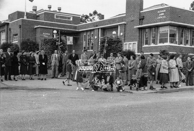
Photograph, Peter Bassett-Smith, Queen Elizabeth II Coronation celebrations and parade, Eltham, Jun 1953
Three black and white photographsalf davis, anz bank, army, arthur street, bert bredle, ceremonies, civic functions, coronation, councillors, cr e.p. harmer, cr f.v. squire, cr frederick e. griffith, cr stanley s. addison, dave lyon house, eltham hall, eltham lower park, eltham shire office, eltham village, eltham, frank davis mhr, guard of honour, main road, mr c.g. seear, mrs alf davis, mrs arthur bird, mrs e.p. harmer, mrs f.e. griffith, mrs frank davis, mrs ham, mrs s.s. addison, mrs squire, parade, queen elizabeth ii coronation, r.j. (dick) ham, shopping centre -
 Eltham District Historical Society Inc
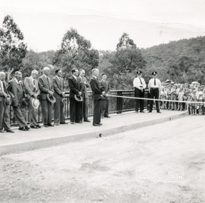
Photograph, Opening Warrandyte Bride, 8 Dec 1955
Built at a cost of £75,000 the five-span reinforced concrete bridge replaced the oldest bridge across the Yarra river, linking the Shire of Doncaster-Templestowe on the south bank with Eltham on the north. The bridge was opened by Mr. G. Reid, M.L.A.Three black and white photographsbridges, warrandyte, yarra river, councillors, ceremonies, stanley addison -
 Eltham District Historical Society Inc
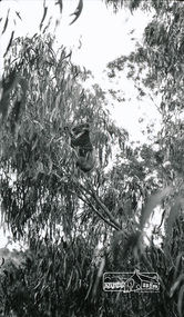
Photograph, Peter Bassett-Smith, Koala in garden of 22 York Street, Eltham, 1928, 1928
Black and white photograph of koala in garden at 22 York Street Eltham, 1928; home of Mr and Mrs W. Bassett-Smithkoala, wildlife, eltham, york street -
 Warrnambool and District Historical Society Inc.
Program, Home & Family Week 1953, 1953
As the photograph on the front page of this pamphlet suggests, the ‘Home & Family Week’ activities may have been inspired by the Coronation of Queen Elizabeth in England. The program for the week included exhibitions, speakers, musical entertainments, a church service, children’s films, public meetings, discussion groups and a youth tea. A committee was formed in Warrnambool to organize the week’s events and the Chairman was Mr Lindsay Anderson.This program is of interest because it gives us details of an event that was staged in Warrnambool in 1953 – Home & Family Week. Many of the speakers and chairpersons for the activities of Home & Family Week were well-known people in the Warrnambool community at the time – Dr H. Holmes, Edith Jacobs, Rupert Philpott, Mrs J.O. Tait, Dr Brauer, Mr E. Willison, Arnold Westgarth etc. This is a pamphlet - one sheet folded in two to make six pages. It has the program for Home & Family Week held in Warrnambool in 1953. The program has blue printing on a beige background. The front page has a photograph in blue and white tonings of Queen Elizabeth, Prince Philip and their two children. As well as the program details the pamphlet contains profiles on some of the speakers and chairpersons and a page promoting the ideas behind the presentation of the week’s sessions.home & family week,, warrnambool, history of warrnambool -
 Warrnambool and District Historical Society Inc.
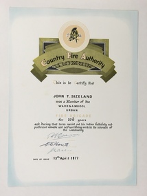
Certificate, Country Fire Authority J T Sizeland, 1977
This is a certificate awarded to John Sizeland of Banyan Street Warrnambool s membership of the Warrnambool Urban Fire Brigade. Mr. Sizeland joined the C.F.A. in 1945 and retired at the compulsory age of 65 in 1977 after over 37 years membership.. The Warrnambool Fire Brigade was established in 1863.This certificate is of interest as it records the work of a prominent fireman in Warrnambool in the 20th century.A sheet of white card featuring a black printing, photocopied hand signatures and a title in an ornamental scroll, a title and a logo of the Country Fire Authority.Country Fire Authority John T. Sizeland john t sizeland -
 Warrnambool and District Historical Society Inc.
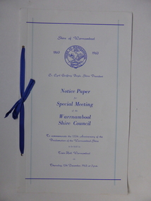
Document, Collett and Bain, Notice of meeting Warrnambool Shire, 1963
This booklet commemorates the 100th anniversary of the proclamation of the Shire of Warrnambool. The original proclamation was read from the Government gazette 13/12/1863 Pg 2958. This follows from being proclaimed a roads district in 1854 which was then partly portioned and proclaimed the Municipal district in 1855. Portion of the shire was again annexed to the city in 1955. The Warrnambool shire covers the area on north east and western sides of the city of Warrnambool covering approximately 600 square miles and has a rich history of farming and dairy products. A program which commemorates 100 years of the shire of Warrnambool. It contains a comprehensive list of councillors who served during that time.White light card cover with royal blue text and tied with royal blue ribbon.Pale blue vertical lines. Shire crest with dates either side at top centre of page.Back cover has list of councillors names who have served from 1863 up to 1963. Photographs in green tinge inside front and back covers. 8 pages. Cr Cyril Geoffery Boyle. Thursday 12th December 1963.Mr Robert Burke, Cr C S Brown, Cr C G Boyle, A F Ponting,The Honourable Murray Porter, Hon R W Mack, Cr J Pascoe, Mr J W Crawley, Mr L Crawley, J Wm Crawley, Jnr, R L Crawleywarrnambool,, warrnambool shire, cr c g boyle, warrnambool shire 1863, warrnambool shire 1963 -
 Warrnambool and District Historical Society Inc.
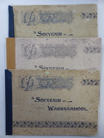
Book, A souvenir of Warrnambool x 5, 1896
These booklets were produced in 1896 by the Warrnambool photographer, Joseph Jordan as a souvenir of Warrnambool with three of them being also souvenirs of the 1896-7 Warrnambool Industrial and Art Exhibition. Joseph Jordan, born in England, took up photography whilst on military service in India. In 1890 he set up as a professional photographer in Warrnambool and became well-known for his family portraits and official photographs of civic dignitaries in the town. He retired in 1916 and the business was continued by his son, Arthur. The Warrnambool Industrial and Art Exhibition was held over three months in 1896-7 in the civic buildings with some temporary buildings added. 70,000 people were said to have attended over that time with concerts, operas, art and sporting competitions and many exhibits. Joseph Jordan had the exclusive rights to publish a souvenir booklet. These booklets are of prime importance because:- 1. They are invaluable pictorial records of Warrnambool and district in the late 1890s. 2. They contain valuable advertisements which give us pictorial representations and other information on businesses in Warrnambool in the late 1890s. 3. Three of them relate directly to the Warrnambool Industrial and Art Exhibition and contain an article dealing with the Exhibition. 4. They contain a written description of Warrnambool in the late 1890s. 5. They show the work of one of our most important photographers, Joseph Jordan and probably also the work of his son, Arthur. These booklets have been published in 1896 by the Warrnambool photographer, Joseph Jordan and contain 15 pages of black and white photographs of Warrnambool and district, many advertisements for local and Melbourne business and an article of the town of Warrnambool. Three of the booklets also contain information on the 1896-7 Warrnambool Industrial and Art Exhibition. Booklet One and Two – dark red hard cover with the title in gold and ornamental scroll work. The cover printing of Booklet Two is almost obliterated. The books are glued and reinforced with string. Booklets Three, Four and Five – soft covers in beige tonings with the title in black print and featuring ornamental scroll work with a sketch of a bird. The covers have much foxing. The booklets are bound with black and brown tape. Booklet One: ‘Ivy Morden’ Booklet Two; ‘Mr Peter Gibbons’ joseph jordan, warrnambool industrial and art exhibition -
 Warrnambool and District Historical Society Inc.
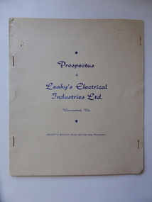
Document, Prospectus Leahy's Electrical, 1951
This prospectus contains the history of Leahy's electrical . The objectives of this company were to allow expansion of the present business ( est,1946) , to take advantage of the excellent corner site and to modernise the building and carry all heavy duty electrical and mechanical lines for commercial users and farmers.Attached was a hire car services which operated as Leahy's Hire cars. The service of the the previous business commenced in 1946 at 82 Fairy Street and grew to employ up to 25 tradesmen. However the assets of the business were lost May1, 1950 when building stock and plant was destroyed by fire.In October 1950 Mr leahy purchased the freehold on the corner of Liebig and Koroit Streets Warrnambool The directors of the new company were John James Leahy, John Beynon Dwyer, William John Taggart Walter, William James Croft, Martin White and James Albert Affleck. They aimed to raise 50000 pounds with 100000 shares at ten shillings each. This document shows the beginnings of one of Warrnambool's most successful 20th century companies. It lists the people associated with it from its inception many of whom were and are well known in the district. It therefore has strong social and historical significance.Cream soft card cover with dark blue text. It is stapled together and contains 6 pages on cream paper with black text.back cover is plain.Prospectus of Leahy's Electrical Industries Ltd Warrnambool Vic, 19th April 1951.warrnambool, j j leahy, jim leahy, leahy's electrical industries, prospectus leahy's electrical industries 1951 -
 Warrnambool and District Historical Society Inc.
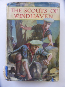
Book, The Scouts of Windhaven, 1940s
This is a book given as a prize to Allan Scarfe in 1942 when he was in Form One at Warrnambool High School. Allan Scarfe, spelled ‘Alan’ in the book inscription, died in 2016. He was a teacher at Warrnambool High School/College for a great number of years and was an author of note. He wrote several works of non-fiction in conjunction with his wife, Wendy, and several novels, mostly crime fiction.This book is of interest because it belonged to Allan Scarfe, a resident of Warrnambool for many years, well-known as a teacher and a writer. It is also of interest as an example of the type of reading material favoured by young boys in the 1940s. This is a hard cover book of 224 pages. The cover is blue with black print on the front cover and spine and a sketch of a sailor on the spine. The dust cover is multi-coloured with sketches of scouts on the front cover and on the spine. The dust cover is ragged at the edges and torn at the bottom part of the spine. The dust cover also has lists of books published by Blackie’s Books. The book has several black and white plates scattered throughout the pages. The inscription on the first page is hand written in black ink. ‘Form 1, Warrnambool High School, 1942, Prize awarded to Alan Scarfe for 7th in Form, gift of Mr G.W. Clarke, R.W.Andrews, B.Sc., B.Ed. Headmaster.’ allan scarfe, warrnambool high school