Showing 1783 items matching "pictorialism"
-
 Orbost & District Historical Society
black and white photographs, Snowy River Mail, 1990
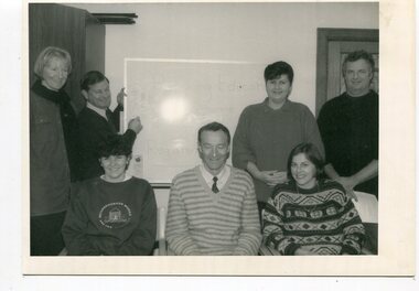
Wendy Blackburn was in charge of T.A..F.E. Orbost and the photographs were taken in her office. Also in the photographs are Tracey Barnett, Peter Cook and Dan Osborne. The Orbost Education Centre is a community based not-for-profit local organisation. It has been in operation since 1976. The programs respond to the needs of the community and short courses are delivered throughout the year for people of all ages and backgrounds. The basis is promoting learning, connectedness and belonging. It is supported by funding from the community, state government and non-government organisations. TAFE offered adult education to those new out of school and mothers coming out of motherhood as well as others. These photographs are pictorial records associated with adult education in Orbost.Five black / white photographs related to adult learning in Orbost. education-adult-orbost t.a.f.e.-orbost -
 Orbost & District Historical Society
black and white photographs, Snowy River Mail, second half 20th century
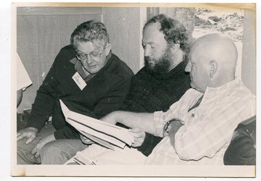
These photographs were taken at the Country Education Project's conference at Dinner Plain, Victoria. The Country Education Partnership (CEP) has been working in the area of rural and remote education for over three decades. It was initially established in Victoria during 1977 and in 2012 it changed its name from Country Education Project. In 3098.9 are Al Balfour (Far East Gippsland Area Coordinator CEP); John Pritchard (Orbost); and Kennie Ellis (Ministry of Education) at FEAST at Dinner Plain. In 3098.10 are: Rod Falconer (Genoa PS); Al Balfour (FEG Coordinator); Jeff Neale ( Club Terrace PS); Lorraine Wylie(Ottways?) and Naomi Ellis (Ministry of Education). They are sharing information at CEP's Dinner Plain conference. In 3098.11 are the East Gippsland representatives at the Country Education Project's Dinner Plain conference. L-R are Al Balfour (far East Gippsland Area CoordinatorCEP); Jeff Neale (Club Terrace)PS); Henrie Ellis ( Ministry of Education); John PritchardThese photographs are pictorial records associated with education in East Gippsland.Three black / white photographs associated with adult education in Orbost.. education-east-gippsland country-education-project balfour-al -
 Orbost & District Historical Society
black and white photographs, 15th February 1971
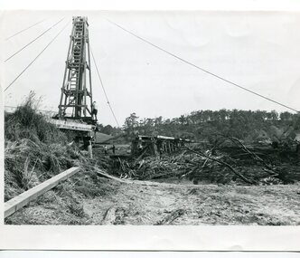
The 1971 flood was the the worst flood on record. At Jarrahmond it was at least 11 metres and up to one and a half kilometres wide on the flats causing enormous damage to the flood plain. Records say that "The brown floodwater stain in Bass Strait could be seen from passing airliners." Considerable damage was done to railway infrastructure, roads and farms. More information from the APRIL, 2008 newsletter by John Phillips. (see orbosthistory.com.au) The railway line was destroyed and was not expected to be opened for a fortnight. Orbost was cut off by 50 square miles of Snowy River floodwater. These photographs are pictorial records of the 1971 floods which was a significant event in the history of Orbost. They are also associated with the East Gippsland Railway.Three black / white photographs of flood debris and flood waters near a railway line. 3102.l has a pile driver 3102.2 shows a gap in the viaduct and 3102.3 shows men with a tractor cleaning up the debris,3102.1 - on back - "1971 FLOOD REPAIRS TO ORBOST RAILWAY VIADUCT - 15th February 1971. Donated by Audrey Van Den Berg VRH 3693" 3102.2 - on back - " DAMAGE TO RAILWAY VIADUCT ACCUMULATED DEBRIS" 3102.3 - on back - "DAMAGE TO RAILWAY VIADUCT AT ORBOST. CLEAN UP BEGINS"orbost-flood-1971 orbost-viaduct-flood-damage orbost-railway -
 Orbost & District Historical Society
album, Cameron, Alex, C1898
The photographs in this album were taken by Alex Cameron in 1898. The captions have been hand-written' Owned by Alexander Cameron who arrived in Australia in 1853. Alexander Cameron ("Big Alex") was an early settler on the Snowy River flats. he worked the paddle steamer Cheviot for a while, having a wharf and sheds on the Snowy River in 1900. Later moved to Cann River. This item is part of the Mary Gilbert Collection.This item is associated with the Cameron family, earty settlers of Orbost. The photographs are pictorial records of early East Gippsland.A ohotograph album with red covers. It contains labelled photographs of East Gippsland. On the front cover a label has been glued on. "Taken by Alex Cameron 1898" is written in red pen.on front cover - KODAK on spine - hand written KODAKcameron-alex photographs-east-gippsland -
 Bendigo Military Museum
Book - BOOK, WW2, The Sun News - Pictorial, "THE FOURTH YEAR OF WAR IN PICTURES", 1944
Refer Cat No. 7503, 7504, 7505, 4 book collection.Hard cover book. Cover - cardboard, with red colour buckram cover, gold print on spine and embossed illustrations on front cover depicting map, aircraft and tank. End papers - illustrated, sepia tones artwork with aircraft and landscape battle scene. 255 pages - cut, plain, white paper. Illustrated in black and white photographs, maps and battle diagrams. Handwritten inscription on page opposite Title Page.Page opposite Title Page - handwritten black ink inscription - "Wishing Kevin a/ Merry Xmas/ from/ Nathalie 1944".books, pictorial, ww2. -
 Bendigo Military Museum
Book - BOOK, WW1, PICTORIAL, Peter BARTON, "THE BATTLEFIELDS OF THE FIRST WORLD WAR", 2005
From front cover- "THE BATTLEFIELDS OF THE FIRST WORLD WAR". "The Unseen Panoramas of the Western front".Box with hard cover book, dust cover and two CD's. 1. Cover - cardboard, with adhered buckram, red colour, white print on spine. Dust cover - paper, with red, black and white print, front, spine and back. Illustrated, black and white photographs. Front cover - "German prisoners and wounded Canadians crossing the battlefield, Passchendaele 1917". Back cover - "Canadian soldiers carrying trench mats. Passchendaele". 376 pages, cut plain, white paper. Illustrated black and white, sepia and colour photographs, maps and diagrams. 2. Box for book - Cardboard, duplicate of print and photographs as per dust cover. Box is open one end. 3. & 4. CD's. - two, plastic CD's in clear plastic storage envelopes adhered to back and paper cardboard cover.books, ww1, pictorial -
 Bendigo Military Museum
Book - BOOK, WW1, Photographs collected and arranged by Francis J Reynolds, "Collier's Photographic history of the European War", WW1
""Collier's Photographic history/ of the European War" including Sketches and drawings made on the battlefields/ PHOTOGRAPHS OF THE OFFICIAL PHOTOGRAPHERS, ACCOMPANYING EACH ARMY/ COLLECTED AND ARRANGED BY FRANCIS J. REYNOLDS AND C. N. TAYLOR".Hard cover book. Cover - cardboard with light grey colour and dark blue fabric spine tape. Black print on front cover and illustrated black and white photograph of a cannon battle scene. 144 pages - cut, plain, glossy white paper. Pictoorial book - illustrated black and white photographs, sketches and drawings.books, pictorial, ww1 -
 Warrnambool and District Historical Society Inc.
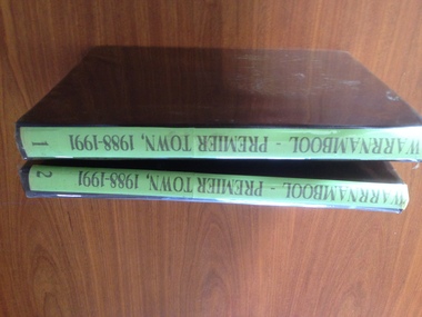
Book - Album, 1988-1991 Premier Town Volume 2, Circa 1988
The Premier towns is an award given by the Victorian state Government. It recognises positive actions by regional communities to protect and enhance their local environment. It is based on criteria relating to litter prevention and waste management, environmental and heritage management as well as activities among community groups and leadership. The following is taken from Hansard at the announcement of the awards in 1988 That the Senate- (a) congratulates the Mayor, Councillors, the Premier Town Committee, and the people of the City of Warrnambool, Victoria, for their achievement, on Saturday, 20 November 1988, in taking out the Victorian `Premier Town Award' for an unprecedented third time; (b) congratulates the business people of Warrnambool for their efforts in helping the city to win the Victorian Industrial and Commercial Development Award, including a special award for coastline preservation and studies This album is significant in that it documents an important award to the City of Warrnambool. It is also a comprehensive pictorial record of Warrnambool as it was in 1988.Volume 2. Covers Warrnambool rivers, bridges, coastal features, places of learning, clubs and sporting facilities and historical and general interest all of which have played an important role in the development of and history of the city and lives of its people.Soft brown vinyl cover with plastic cover. Pages are dark cream cover paper. A sticker with the Warrnambool Premier Town logo is inside the front cover. The album consists of photographs of various buildings and streetscapes with relevant descriptive text.Sticker inside front cover, Mr J Gietz Po Box 1007 Warrnambool Vic 3280. warrnambool, ideal town 1988-1991, victoria’s bicentennial premier town premier town awards -
 Kiewa Valley Historical Society
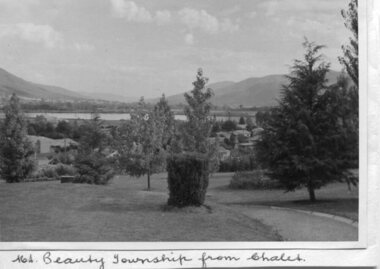
Photos - Mt Beauty and Surrounds, March 1960
Photos of the Kiewa Hydro Scheme and townships as they were in March 1960Pictorial record of the Hydro Electric Scheme in the 1960's when it was operated by the State Electricity Commission of Victoria (SECV). With the privatisation of the SECV in the 1990's the scheme passed to Southern Hydro and was then acquired by ALG Energy in 2005.4 black and white photographs of the Kiewa Valley area taken on a tour of the Kiewa Hydro Electric Scheme in March 1960 1. Mt Beauty township taken from the Mt Beauty Chalet 2. Mt Bogong, taken from Tawonga Gap 3. McKay portal pipeline 4. Bogong townshipmt beauty, kiewa hydro electric scheme, bogong, secv -
 Kiewa Valley Historical Society
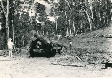
Photo - Mountain Creek Logging Camp, 1955
Hume and Hovell discovered the area in 1824 and by the end of the 19th century the valley was transformed by logging, dairy and beef cattle properties and tobacco farms. The logs could have been milled for timber at the State Electricity Commission's mill at Howman's Gap which provided a much needed source of timber for construction of McKay Creek Power Station which began construction in 1951 and also the camps and houses for the workers and their families. There was a need for housing and infrastructure for an increasing population of workers for the hydro-electric scheme as there was a general shortage of this commodity. A timber mill was started in Tawonga by Mates, of Albury, in 1945, and electricity became available in 1946 the S.E.C. bought the mill, and enlarged it. In 1960 it was purchase by a local family, they also started a timber mill in Mt Beauty worked both until 1980 when they closed it. The Tawonga mill and enlarged the mill called Mt. Beauty Timbers Pty Ltd employed approximately 50 people. An historical pictorial record of the general working conditions, type of machinery and vehicles in use in the 1950’s. Note the lack of protective clothing!Black and white photograph of the logging camp at Mountain Creek. November 1955Handwritten on the back of photograph - MOUNTAIN CREEK LOGGING CAMP NOV 55mountain creek logging camp, timber industry, tawonga -
 Kiewa Valley Historical Society
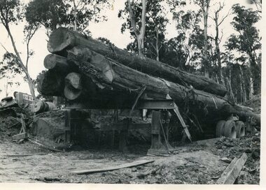
Photo - Logging. Mountain Creek, November 1955, November 1955
Hume and Hovell discovered the area in 1824 and by the end of the 19th century the valley was transformed by logging, dairy and beef cattle properties and tobacco farms. The logs could have been milled for timber at the State Electricity Commission's mill at Howman's Gap which provided a much needed source of timber for construction of McKay Creek Power Station which began construction in 1951 and also the camps and houses for the workers and their families. There was a need for housing and infrastructure for an increasing population of workers for the hydro-electric scheme as there was a general shortage of this commodity. A timber mill was started in Tawonga by Mates, of Albury, in 1945, and electricity became available in 1946 the S.E.C. bought the mill, and enlarged it. In 1960 it was purchase by a local family, they also started a timber mill in Mt Beauty worked both until 1980 when they closed it. The Tawonga mill and enlarged the mill called Mt. Beauty Timbers Pty Ltd employed approximately 50 people An historical pictorial record of the general working conditions, type of machinery and vehicles in use in the 1950’s. Black and white photograph of logging at Mountain Creek November 1955Small typed note attached to the back of photo - Logging Mountain Creek November 1955mountain creek logging camp, tawonga, timber industry -
 Kiewa Valley Historical Society
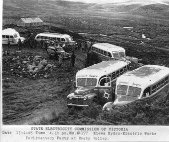
Photograph - Parlimentary Party visiting Rocky Valley Dam site, 15-4-1948
This photograph was taken during construction of the Rocky Valley Dam and wall. Work was commenced in early 1947 but had to be suspended during winter and then resumed in October. Work continued in 1948 with the establishment of work facilities and, at the dam site, the river was diverted through a temporary pipeline. Rocky Valley and associated spillway and outlet works were completed in 1959.A pictorial record of the construction of the rock and earth filled dam wall at Rocky Valley. Shows the extent of the project undertaken and the level of importance of the project as indicated by the large representation at the parliamentary party visit on 15/4/48.Photocopy of black and white photograph of parliamentary party visiting Rocky Valley Dam site 15/04/1948Typed on the bottom of photocopy - State Electricity Commission of Victoria. Date: 15-4-48 Time: 4.30pm No: K4397. Kiewa Hydro-Electric works. Parlimentary Party at Rocky Valleyrocky valley dam, parliamentary party, secv -
 Kiewa Valley Historical Society
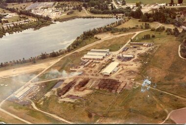
Photograph - Mt Beauty timber Industries, 1960's (estimate only)
Hume and Hovell discovered the area in 1824 and by the end of the 19th century the valley was transformed by logging, dairy and beef cattle properties and tobacco farms. Timber was required for construction of McKay Creek Power Station which began construction in 1951 and also the camps and houses for the workers and their families. There was a need for housing and infrastructure for an increasing population of workers for the hydro-electric scheme as there was a general shortage of this commodity. A timber mill was started in Tawonga by Mates, of Albury, in 1945, and electricity became available in 1946 the S.E.C. bought the mill, and enlarged it. In 1960 it was purchase by a local family. They also started a timber mill in Mt Beauty and worked both until 1980 when they closed the Tawonga mill and enlarged the mill called Mt. Beauty Timbers Pty Ltd which employed approximately 50 people. A pictorial record of the development of the Mt Beauty community and the local timber industry.Colour photograph of aerial view of Mt Beauty Timber Mills and surrounding area including pondage and part of airfield. Photo taken in 1960’s (estimate only)Handwritten in ink on back of photograph in very faint writing – Recent photo of Mt Beauty Timber Industries Mt Beauty Operationsmt beauty timber industry, timber industry, timber mill, secv -
 Kiewa Valley Historical Society
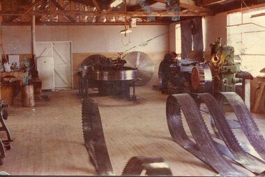
Photograph - Mount Beauty Timber Industries, 1960's (estimate only)
Hume and Hovell discovered the area in 1824 and by the end of the 19th century the valley was transformed by logging, dairy and beef cattle properties and tobacco farms. Timber was required for construction of McKay Creek Power Station which began construction in 1951 and also the camps and houses for the workers and their families. There was a need for housing and infrastructure for an increasing population of workers for the hydro-electric scheme as there was a general shortage of this commodity. A timber mill was started in Tawonga by Mates, of Albury, in 1945, and electricity became available in 1946 the S.E.C. bought the mill, and enlarged it. In 1960 it was purchase by a local family. They also started a timber mill in Mt Beauty and worked both until 1980 when they closed the Tawonga mill and enlarged the mill called Mt. Beauty Timbers Pty Ltd which employed approximately 50 people. A pictorial record of the development of the local timber industry in the Kiewa Valley showing equipment used in timber milling.Colour photograph of Mt Beauty Timber Industries Mill. Photo taken inside the workshop showing saw blades and equipmentmt beauty, mt beauty timber industry, timber mill -
 Kiewa Valley Historical Society
3 X photographs of early residents of the Kiewa Valley, 1. 1949-1950
The 3 photographs are of early residents of the Kiewa Valley who have pursued varying careers. Pictorial history of early residents of the Kiewa Valley giving an insight into the accomplishments of some local residents ie: R Nicholls and T Hotter travelled from New Zealand to work in the Kiewa Valley. J.H. Thompson pursued a career as a police officer. W.M. Sloan and his father built the water wheel at Junction Creek.1. Black and white photograph of Rod Nicholls and Tom Hotter, both of Mt Egmont New Zealand 2. Black and white photograph of J.H Thompson Former pupil of Mongan’s Bridge School 3. Black and white photograph of W M Sloan taken in 1880’s. Photograph is an oval within a larger rectangle 1. Handwritten in black pen on back of photo – Rod Nicholls (wearing hat) & Tom Hotter Both of Hawera (Mt Egmont) New Zealand 1949 – 1950 2. Handwritten on the back of photograph in ink J H Thompson, A fond memory for Mrs. Fisher, Everil & Paddy. Former pupil of Mongan’s Bridge school 3. Handwritten on back of photograph in blue ink – W M Sloan. He and his father built the water wheel 1880’s on Junction Creek (Bakers) j h thompson, fisher family, mongan's bridge, w m sloan, kiewa valley -
 Kiewa Valley Historical Society
Photographs x 2 - Afternoon tea visit to Towong Hill
Towong Hill Homestead is a 110-year-old Federation style mansion situated on a rock outcrop, with views of about 260 degrees. It was built over 2 years by grazier Walter Mitchell from bricks made from local clay dug from the river bank, to be the family home for his new bride Winifred. They established their home in 1904. After the death of Walter in 1917, Winifred relocated her family, but the homestead remained in the families hands. In 1935, Thomas Mitchell (1906-1984) returned home to Australia, a successful Lawyer, and married city girl, Elyne Chauvel, and settled himself back at his childhood home, Towong Hill. Thomas was a world champion slalom skier, had been a prisoner of the Japanese at Changi, and was elected for the Country Party in 1946 and served as attorney-general in the McDonald government. His wife Elayne (1913-2002) is best remembered for her Silver Brumby series of novels for children. But Elyne also wrote a substantial number of non-fiction works about the Snowy Mountains. Photographs demonstrate local Kiewa Valley residents enjoying a community visit to the historic homestead at Towong Hill which holds significance to the early history of the area. Also demonstrates a pictorial history of social activities undertaken during this period2 black and white photographs mounted on buff card. Kiewa Valley residents attending afternoon tea at Towong HillHandwritten in black pen underneath photo - T.W.Mitchell Towong Hill. Afternoon Teat w mitchell, towong hill, kiewa valley -
 Kiewa Valley Historical Society
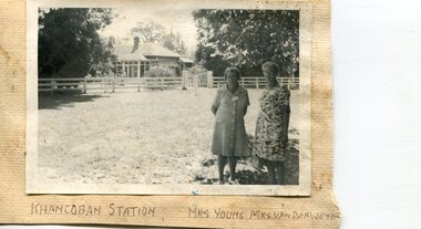
Photographs x 2- Khancoban Station and Comet the horse
In 1824, Hume and Hovell were the first Europeans to pass through the district and graziers soon followed, impressed by the abundance of fodder and water. The first cattle run in the area was settled in about 1838 in what was known as Swampy Plains. Later, this run became known as “Khancoban Station”. Khancoban lies in the heart of the high country and is home of Australia’s mountain cattlemen. This heritage is celebrated in Banjo Paterson’s epic poem, “The Man from Snowy River”. In 1962, Bruce and Jo Chisholm relocated from Bond Springs to Khancoban Station, which Bruce had acquired in 1959. Khancoban Hereford and thoroughbred stud progeny were keenly sought after whenever they were presented in the sale ring. Bruce imported a stallion, Comet, from England in 1964. Comet stood at Khancoban for 15 years and was the sire of numerous winners, including Cobbermine, Kelly's Eye, Boack and Starglow. Photographs demonstrate local Kiewa Valley residents enjoying a community visit to the historic homestead at Khancoban Station which holds significance to the early history of the area. Its heritage is celebrated in Banjo Paterson’s epic poem, “The Man from Snowy River”. Also demonstrates a pictorial history of social activities undertaken during this period Black and white photographs mounted on buff card 1. Kiewa Valley residents visiting Khancoban Station 2. Photo of thoroughbred horse Comet and handler at Khancoban Station1. Handwritten in black ink below photo- Khancoban Station. Mrs. Young, Mrs Van Der Weyde 2. Handwritten in black ink above photo- "Comet' at Khancobankiewa valley residents, clare roper -
 Kiewa Valley Historical Society
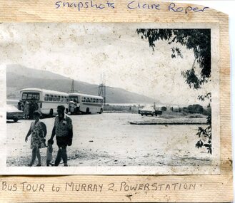
Photograph- Bus tour to Murray 2 Power Station
The Murray Region Hydroelectric Power Stations are two of seven hydro power stations, located near Khancoban in NSW. The two power stations are part of the Snowy Mountains Hydro-electricity Scheme, which is an extensive hydroelectricity and irrigation complex constructed in south-east Australia between 1949 and 1974 and now run by Snowy Hydro. Although both power stations are located in NSW, since 1 July 2008 all power generated has been allocated to the Victorian region of the National Electricity Market. Murray 2 Power Station was the first in the Snowy Scheme to use Japanese supplied large electrical and mechanical components Photographs demonstrate local Kiewa Valley residents enjoying an educational visit to Murray 2 Power Station which holds significance to the early history of the Hydro-electric Scheme in the area. Also demonstrates a pictorial history of social activities undertaken during this periodBlack and white photograph mounted on buff card Bus tour to Murray 2 Power Station showing 2 buses and group of Kiewa Valley residentsHandwritten in blue ink above photo "Snapshots Clare Roper' Handwritten in black ink below photo "Bus tour to Murray 2 Power Station'kiewa valley residents, clare roper -
 Kiewa Valley Historical Society
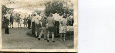
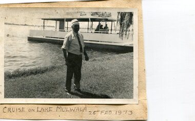
Photographs x 3- Cruise on Lake Mulwala, 25/2/1973
Lake Mulwala is a man–made reservoir created through the construction of the Yarrawonga Weir across the Murray River, is located between Bundalong and Yarrawonga in Hume region of Victoria and Mulwala in the Riverina region of New South Wales, in eastern Australia. The weir was constructed in 1939 to provide water for irrigation of the surrounding district. The weir also serves as a crossing of the Murray between the two towns. It is a popular tourist destination for boating, fishing and other water recreation.Photographs demonstrate local Kiewa Valley residents enjoying a visit to the picturesque area of Lake Mulwala. Also provides a pictorial history of 1973.3 black and white photographs mounted on buff card. Photographs of a cruise on Lake Mulwala 25th Feb. 1973 1. Photo of unidentified man standing on the shore of Lake Mulwala beside cruise launch. 2. Group photo of people standing by cruise boat as others disembark. Woman in centre holding handbag may be Clare Roper (unconfirmed) 3. Photo of 2 men aboard cruise launch looking out over Lake Mulwala1. Handwritten at bottom of photo in black ink. 'Cruise on Lake Mulwala. 25th Feb. 1973' 2. Painted sign above cruise launch- Scenic Lake Cruises 3. No markingsclare roper -
 Kiewa Valley Historical Society
Photographs x 2 1. Lake Guy & Bogong Village 2. Bulldozer moving rocks
1. In 1940 Field Headquarters for the Kiewa Scheme were established at Bogong with office, workshop facilities and accommodation for workmen, staff and some families constructed. (There had been a 'tent camp' on this site in 1939 but was destroyed by bushfires) Construction of accommodation continued until 1947. A total of 40 houses plus a hostel for single staff, post office, police station, medical centre and primary school all with water and sewerage and electricity supply. The staff hostel was known as Kiewa House and is now occupied by the Education Department. Lake Guy was named after Mr. L.T. Guy who was the Resident Engineer in charge of construction work and associated activities on the Kiewa area. He held this position from 1939 to November 1946 when he was transferred to Head Office. 2. Example of the type of heavy machinery used in clearing and building of Lake Guy, Bogong Village and Clover Dam 1. The Bogong Township was developed firstly as an accommodation centre (base camp) for construction workers employed under the Kiewa Hydroelectric Scheme. At the completion of the scheme, in the 1960's, the village was opened to public/tourism use. Strict environmental control has not allowed for any extensive redevelopment in tourist accommodation and basically restricted it to the accommodation initially built for the construction workers. Lake Guy is one of the many water storage reservoirs used to supply the power stations their main power to run the huge turbines generating the final product, electricity 2. Pictorial record of the types of machinery used in the development of Bogong Village and the Hydro-electricity scheme including the Clover Dam. Note the lack of safety equipment worn by construction workers of the period. 2 black and white photographs taken at Bogong 1. Lake Guy with Bogong Village in the background 2. Workman in bulldozer clearing rocks, possibly for construction at Bogong1. Handwritten in blue ink on back of photo 'Lake Guy showing Bogong Village' 2. No markingslake guy, bogong village, secv -
 Kiewa Valley Historical Society
Photographs – Kiewa Cres Mt Beauty. Circa 1993. Set of 12 colour photographs
Established in 1946, during the construction of the Kiewa Hydro Electric Scheme, the township of Mt Beauty was developed by the State Electricity Commission of Victoria to provide additional accommodation for the thousands of workers during the construction of the country’s second largest hydro-electricity scheme. Although these towns were built as temporary accommodation for the workers and their families, many stayed after the scheme finished. Combined with the influx of European migrants, with their rich cultural backgrounds, all played a major part in shaping the future character of the Mount Beauty, the Kiewa Valley and Falls Creek. The Bright Council, now the Alpine Shire took over the control of the township in 1960. This relatively young town of Mount Beauty, along with the surrounding townships of Falls Creek, Bogong, Tawonga South and Tawonga, are all part of a prospering tourist area with excellent services, accommodation, food and a wide range of recreational activities available for all ages. According to Shire records, the population of Mt Beauty has grown from 1,500 in 1981 to 1,800 in 2016 with a projected increase to 2,000 in 2013The photographs taken around 1993 show a prosperous commercial centre catering for both locals and the needs of visitors. It provides a pictorial history of the changes which have occurred in the retail/commercial district of Mt Beauty over the years. It also demonstrates the attention paid by Alpine Shire towards providing accessible recreational green space around the town centre.Set of 12 colour photographs of Kiewa Cres Mt Beauty. Circa 1993 showing retail services and streetscape of the time. No markingskiewa cres mt beauty, mt beauty -
 Kiewa Valley Historical Society
Photographs – Lakeside Avenue, Mt Beauty. Circa 1993. Set of 7 colour photographs
Established in 1946, during the construction of the Kiewa Hydro Electric Scheme, the township of Mt Beauty was developed by the State Electricity Commission of Victoria to provide additional accommodation for the thousands of workers during the construction of the country’s second largest hydro-electricity scheme. Although these towns were built as temporary accommodation for the workers and their families, many stayed after the scheme finished. Combined with the influx of European migrants, with their rich cultural backgrounds, all played a major part in shaping the future character of the Mount Beauty, the Kiewa Valley and Falls Creek. The Bright Council, now the Alpine Shire took over the control of the township in 1960. This relatively young town of Mount Beauty, along with the surrounding townships of Falls Creek, Bogong, Tawonga South and Tawonga, are all part of a prospering tourist area with excellent services, accommodation, food and a wide range of recreational activities available for all ages. According to Shire records, the population of Mt Beauty has grown from 1,500 in 1981 to 1,800 in 2016 with a projected increase to 2,000 in 2013The photographs taken around 1993 show a prosperous commercial centre catering for both locals and the needs of visitors. It provides a pictorial history of the changes which have occurred in the retail/commercial district of Mt Beauty over the years. It also demonstrates the attention paid by Alpine Shire towards providing accessible recreational green space around the town centre.Set of 7 colour photographs of Lakeside Avenue, Mt Beauty. Circa 1993 showing retail services and streetscape of the time. No markingsmt beauty, lakeside ave mt beauty -
 Kiewa Valley Historical Society
Photographs – Tawonga Cres., Mt Beauty. Circa 1993. Set of 4 colour photographs
Established in 1946, during the construction of the Kiewa Hydro Electric Scheme, the township of Mt Beauty was developed by the State Electricity Commission of Victoria to provide additional accommodation for the thousands of workers during the construction of the country’s second largest hydro-electricity scheme. Although these towns were built as temporary accommodation for the workers and their families, many stayed after the scheme finished. Combined with the influx of European migrants, with their rich cultural backgrounds, all played a major part in shaping the future character of the Mount Beauty, the Kiewa Valley and Falls Creek. The Bright Council, now the Alpine Shire took over the control of the township in 1960. This relatively young town of Mount Beauty, along with the surrounding townships of Falls Creek, Bogong, Tawonga South and Tawonga, are all part of a prospering tourist area with excellent services, accommodation, food and a wide range of recreational activities available for all ages. According to Shire records, the population of Mt Beauty has grown from 1,500 in 1981 to 1,800 in 2016 with a projected increase to 2,000 in 2013The photographs taken around 1993 show a prosperous commercial centre catering for both locals and the needs of visitors. It provides a pictorial history of the changes which have occurred in the retail/commercial district of Mt Beauty over the years. It also demonstrates the attention paid by Alpine Shire towards providing accessible recreational green space around the town centre.Set of 4 colour photographs Tawonga Crescent, Mt Beauty. Circa 1993 showing retail services and streetscape of the time No markingstawonga cres mt beauty -
 Kiewa Valley Historical Society
Photographs – Holland Street North, Mt Beauty. Circa 1993. Set of 18 colour photographs
Established in 1946, during the construction of the Kiewa Hydro Electric Scheme, the township of Mt Beauty was developed by the State Electricity Commission of Victoria to provide additional accommodation for the thousands of workers during the construction of the country’s second largest hydro-electricity scheme. Although these towns were built as temporary accommodation for the workers and their families, many stayed after the scheme finished. Combined with the influx of European migrants, with their rich cultural backgrounds, all played a major part in shaping the future character of the Mount Beauty, the Kiewa Valley and Falls Creek. The Bright Council, now the Alpine Shire took over the control of the township in 1960. This relatively young town of Mount Beauty, along with the surrounding townships of Falls Creek, Bogong, Tawonga South and Tawonga, are all part of a prospering tourist area with excellent services, accommodation, food and a wide range of recreational activities available for all ages. According to Shire records, the population of Mt Beauty has grown from 1,500 in 1981 to 1,800 in 2016 with a projected increase to 2,000 in 2013The photographs taken around 1993 show a prosperous commercial centre catering for both locals and the needs of visitors. It provides a pictorial history of the changes which have occurred in the retail/commercial district of Mt Beauty over the years. It also demonstrates the attention paid by Alpine Shire towards providing accessible recreational green space around the town centre.Set of 18 colour photographs Holland Street North, Mt Beauty. Circa 1993 showing retail services and streetscape of the time. No markingsholland st mt beauty, mt beauty -
 Kiewa Valley Historical Society
Photographs – Holland Street South, Mt Beauty. Circa 1993. Set of 16 colour photographs
Established in 1946, during the construction of the Kiewa Hydro Electric Scheme, the township of Mt Beauty was developed by the State Electricity Commission of Victoria to provide additional accommodation for the thousands of workers during the construction of the country’s second largest hydro-electricity scheme. Although these towns were built as temporary accommodation for the workers and their families, many stayed after the scheme finished. Combined with the influx of European migrants, with their rich cultural backgrounds, all played a major part in shaping the future character of the Mount Beauty, the Kiewa Valley and Falls Creek. The Bright Council, now the Alpine Shire took over the control of the township in 1960. This relatively young town of Mount Beauty, along with the surrounding townships of Falls Creek, Bogong, Tawonga South and Tawonga, are all part of a prospering tourist area with excellent services, accommodation, food and a wide range of recreational activities available for all ages. According to Shire records, the population of Mt Beauty has grown from 1,500 in 1981 to 1,800 in 2016 with a projected increase to 2,000 in 2013The photographs taken around 1993 show a prosperous commercial centre catering for both locals and the needs of visitors. It provides a pictorial history of the changes which have occurred in the retail/commercial district of Mt Beauty over the years. It also demonstrates the attention paid by Alpine Shire towards providing accessible recreational green space around the town centre.Set of 16 colour photographs Holland Street South, Mt Beauty. Circa 1993 showing retail services and streetscape of the time. No markingsholland st mt beauty, mt beauty -
 Kiewa Valley Historical Society
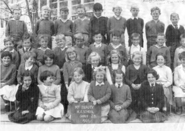
Photograph – Mt Beauty Higher Elementary School Grade 2B, 1960 – Black and white photocopy of original photograph
On Feb 3rd 1948, the Mt Beauty State School was opened with 28 pupils in all grades up to VII. Classes began in the SECV Recreation Hall, which was converted to classrooms during the school week and returned to a recreation hall on weekends for motion pictures and social occasions for SECV workers and their families. A new school building was opened in 1950 on the current school site, with an enrolment of 170 primary and secondary students. A further extension of 4 buildings was added in 1951 with a population increase to 303 students. In May 1953, the status of the school was raised to Higher Elementary School with a total of 403 students. In 1958, the school population rose to a high of 617 students with 436 in primary and 181 in secondary. In 1964, the status of the secondary section of Mt Beauty HES was raised to a High School and was moved to separate facilities in the west of town in September 1964 Pictorial history of children who attended Mt Beauty Higher Elementary School in 1960. Many of the students would have had parents working on the Hydro-Electric Scheme in and around Mt Beauty. Many of the children would also have been the descendants of parents who immigrated to Australia as foreign workers on the Hydro Electric Scheme such as Alex Van De Ruijt, whose parents were Dutch. Photocopy of a black and white class photograph of Mt Beauty H E School Grade 2B, 1960 Back row: Lawrence Woods, John Wayne, Terry Hertzog, Phillip Jervies, ?, Alex Van De Wright , ?John Sigmund, Wayne Shoebridge, Brian Harkin 3rd row: Doug Newbound, Roy Hetherington, ? Kevin Hills, Peter Renshaw, ? Grenville Gerecke, ?, Ken Thomas, Detlef Rueff, ?, not in picture Berndt Homfeld 2nd Row, ?, Lyn Plant, ?, Gabrielle Sigmund, ? Pauline Gerecke, Christine Harmer, ?, Lesley McDonald, not in picture, Jenny Richardson Front Row, ? Christine Pennery, Robyn Symons, ?, ?, Sue Mckendrick, ?, ? with a name may not be correct Chalk Board at front of children in photograph – MT BEAUTY H.E.SCHOOL GRADE 2B. 1960 Handwritten in top right hand corner of photograph, with arrow pointing to the boy 4th from the right Alex Van De Auigh (Ruijt) dutch now De Wright Handwritten on back of photograph – Top row: 6 from left (4th from Right) mt beauty school -
 Kiewa Valley Historical Society
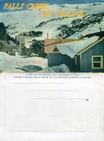
Souvenir Postcard Folder – Falls Creek Ski Village
After World War II, the Kiewa Hydroelectric Scheme was started in the Kiewa River valley by the State Electricity Commission of Victoria. On land previously used only for summer cattle grazing in the natural alpine grasslands, the first ski lodge was built in 1948 by workers from the scheme. The first lift, a rope tow, was built in 1951 and the first chairlift in Australia was constructed there in 1957. Falls Creek Post Office opened on 9 June 1958 (with telegraph and telephone facilities only until 1964) .Despite strong opposition from the head of the Kiewa scheme, who didn't want tourists clogging up his roads and destroying his "dry" construction camps by bringing in booze, Falls Creek boomed as much as Hotham, partly owing to its relatively good access road. Early lodges included Bogong (c.1946), Skyline (1947), Albury (1949), Myrtleford (1949) and Dawn (c.1950).The souvenir postcard photographed and produced by an enterprising local businessman Mr S K Pearce, was produced as a memento for skiers and other visitors to the Falls Creek and Mt Beauty area to send to family and friends as a reminder of their visit to the region, or to keep as a personal souvenir. It presented an excellent promotional opportunity for enterprising local businessmen to promote the area to skiers and tourists near and far. It also presents an excellent pictorial history of the falls creek area around the late 1950’s to early 1960’sColour postcard folder (unused) containing 13 photographs of the Falls Creek ski area and surrounds. Inside cover has a brief description of the area and the services available to visitors Printed on front cover- FALLS CREEK SKI VILLAGE. Your Souvenir Folder Photo of skiing slopes of the village Inside front flap - a brief description of the Falls Creek area and the services available to visitors 1. Diana Lodge parking area and Spion Kopje 2. Winterhaven Lodge 3. Ski Hirage Centre and skiing slopes 4. Ski Lodges from main road 5. Nelse and Arundel Lodges 6. Day visitors’ shelter and parking area 7. Summit T-Bar lift 8. Spur T-bar looking towards Village and Spion Kopje 9. T-bar lower station and Snow Crystal Inn 10. ‘Akja’ rescue sled in use 11. Falls Creek road and Grand Coeur Lodge annex 12. Rope tows and beginner slopes 13. Back cover- Published by Nucolorvue Pty Ltd Mentone Vic. Printed in Australia For S.K.Pearce Pty Ltd Tawonga and Mt Beauty falls creek, snow, bogong high plains, victorian alps -
 Kiewa Valley Historical Society
Photographs – Set of 10 black and white photographs and photocopies of original photographs documenting early residents of Bogong Village
Bogong Village, which was known as “The Junction”, is well recorded. The first tent camp was at the junction of Pretty Valley and Rocky Valley streams in the early 40’s. Further downstream were the sawmill, stables and blacksmith’s forge. Horses were the main mode of transport in the early days. The road to Bogong had reached the lookout spur just beyond Roper’s Spur track just before the 1939 fires. The early forties saw rapid growth of the village, with single and married men’s quarters, workshops, mess huts and administrative offices. The facilities necessary for communal living were quickly in place- a post office, police station, co-op store, medical centre, community hall/theatre, tennis courts and school. Much of the temporary accommodation that housed groups such as the Albion Quarrying Company were in the area now under water.This group of photographs are a pictorial record of the early history of the Kiewa Hydro Scheme, the people who worked in the background supplying administrative support and the workers and their families. It also shows a glimpse into how a large group of people from very diverse backgrounds came together to enjoy social activities and share each others companyGroup of 10 black and white photographs and photocopies of original photographs of varying sizes (some official SECV photos) Some Photos are labelled with the date and the names of SECV staff members. Depicting early life at Bogong Village 1. Group photo – Kiewa House Residents 1.8.41 (SECV official photo) 2. Female staff residents 3. Female office staff 4. Kitchen staff – Junction Mess (SECV official photo) 5. Male administration staff Bogong 6. Bogong Social Club fancy dress ball, 1940 7. Wives and children of SECV workers 8. Children in fancy dress 9. Opening of Volunteer Air Observers post 1943 10. Flag raising at opening of Volunteer Air Observers post 1. Printed under photo: STATE ELECTRICITY COMMISSION OF VICTORIA Date: 1.8.41 Time: 12.30pm No:K 435 Kiewa Hydro-Electric Works. Kiewa House Residents Back Row L to R: S.A. Salmon, W. Strachn, T.A Connors, W.J Norman, R.C Grealey, R.D Hegarty, Mrs Hegarty, W.R Morgan, S.A Clarke, P. Morgan, P.J. Harnetty, G.W Crouch. Front Row L to R: W.L Godfrey, R.S Hollands, Pte. R Charlesworth, R.L Dunn, N Caldwell, L.T Davies, I Webber, H.L Kendall, P Tiller, Ricky Hegarty, L.T Guy, M.C Cox, K.F Calder, D.S Gibson 2. Printed on bottom: Staff who lived at Kiewa House and worked in the Administration Office c 1943 Handwritten at bottom Priscilla Johnson (nee Reid) At top of page A GOOD LIFE: WOMEN’S RECOLLECTIONS OF LIFE IN THE UPPER KIEWA VALLEY 3. Printed under photo- Office Staff – Bogong 4. Printed under photo: STATE ELECTRICITY COMMISSION OF VICTORIA Date: 18.5.40 Time: 11.05am No:K 103. Kiewa Hydro-Electric Works. Kitchen Staff- Junction Mess. Opening night of the new staff mess Bogong. 5. Printed under photo -Administration staff Bogong 6. Printed under photo- The social club raised money for patriotic fund from fancy dress nights. (1st Fancy Dress Ball, Bogong 1940) 7. Printed above photo: ---- and family life begins (1942 Bogong) 8. Printed under photo: A favourite photograph 9. Printed under photo: STATE ELECTRICITY COMMISSION OF VICTORIA Date: 24.5.43 Time: 2.8pm No:K 1151 Kiewa Hydro-Electric Works. Bogong- Squadron Leader Leggett speaking at opening of Air Observer’s Post 10. Printed under photo: Raising the flag at the opening of the Volunteer Air Observer’s Post at Bogong - 1943 bogong village; kiewa hydro electric scheme; social activities; community clubs -
 Kiewa Valley Historical Society
Photographs – Set of 9 black and white photographs and photocopies of original photographs depicting the early days of Bogong Village during the 1940’s, circa 1940's
Bogong Village, which was known as “The Junction”, is well recorded. The first tent camp was at the junction of Pretty Valley and Rocky Valley streams in the early 40’s. Further downstream were the sawmill, stables and blacksmith’s forge. Horses were the main mode of transport in the early days. The road to Bogong had reached the lookout spur just beyond Roper’s Spur track just before the 1939 fires. The early forties saw rapid growth of the village, with single and married men’s quarters, workshops, mess huts and administrative offices. The facilities necessary for communal living were quickly in place- a post office, police station, co-op store, medical centre, community hall/theatre, tennis courts and school. Much of the temporary accommodation that housed groups such as the Albion Quarrying Company were in the area now under water.Pictorial history of the early years of Bogong Village including one photo taken following the devastating fires of 1939. Photos show the terrain in which Bogong Village was built, the early construction used for the temporary buildings and the housing and the amount of infrastructure required to accommodate the needs of the residents of the area including workers, their families and other support staff. Set of 9 black and white photographs and photocopies of photographs depicting early buildings at Bogong Village . Photos show very early construction buildings as well as the village in various weather conditions, including snowing and after bush fires. (some official SECV photographs) 1. Bogong Village in heavy snow 2. Bogong Township during heavy snow (SECV Official Photo) 3. VIP Lodge at Bogong in the snow 4. Bogong Village - circa 1940’s 5. Bogong Village under street lights 6. Lewis Construction Camp (SECV Official Photo) 7. Albion Quarrying Co. Camp (SECV Official Photo) 8. Tent camp and early buildings following 1939 fires 9. Typical house – Bogong Village 1. Handwritten under photo – August 1948 2. Printed under photo: STATE ELECTRICITY COMMISSION OF VICTORIA Date: 25.8.48 Time: 9am No:K 4680 Kiewa Hydro-Electric Works. Bogong Township 3. Handwritten on back of photo- V.I.P. Lodge, Bogong 4 – 5. No markings 6. Printed under photo: STATE ELECTRICITY COMMISSION OF VICTORIA Date: 28.11.40 Time: 1.40pm No:K284 Kiewa Hydro-Electric Works. Lewis Construction Camp 7. Printed under photo: STATE ELECTRICITY COMMISSION OF VICTORIA Date: 11.1.41 Time: 10.40am No:K294 Kiewa Hydro-Electric Works. Albion Quarrying Co. Camp – Bogong. Handwritten on back of photo: On the floor of the present dam 8. No markings 9. Printed under photo: STATE ELECTRICITY COMMISSION OF VICTORIA Date: 11.1.46 Time: 1.23pm No:K2181 Kiewa Hydro-Electric Works. Bogong – Typical House bogong village; 1939 fires; kiewa hydro electric scheme; -
 Kiewa Valley Historical Society
Set of 2 hand coloured photographs of early Mount Beauty, photographs of Mount Beauty, 1947/48
Construction of the town of Mount Beauty commenced in 1946 and continued until 1952. It was built to provide family accommodation for workers engaged in the construction of the hydro electric power scheme. As well as housing, there was an administration building, staff hostel, merchandising centre, workmen's camps, base stores and workshops and the Mount Beauty Terminal Station. The first house was occupied in November, 1946 by the then manager of the trading store, with a frontage onto Hollonds Street. The total number of houses erected was 488, 162 custom built and 326 prefabricated. The main workmen's camp can be seen just left of the centre of the photograph and accommodated 144 men at the time of the photograph. By 1950 it could accommodate 1200men. Photo No. 1 is taken in 1947/early 1948 as there is no evidence of the staff hostel under construction. This hostel was commenced in August/September 1948 and is clearly shown in photograph No. 2, dating this photo as 1948 as it is before the completion of the bypass road connecting to the main (high plains) road. This road was constructed in 1939 and in 1948 followed the route of Tawonga Crescent. This remained in use until the bypass construction was completed in early 1949 and does not appear to be finished in this photograph.. Both photographs are taken from the power line easement adjacent to the Bright road.Significant historical pictorial record of the development of a town from grazing land. The type of terrain that had to be surveyed and then to construct roads and other infrastructure, with very little machinery, is also of prime significance in the development of the Kiewa Hydro Electric Scheme.Two photographs, both hand painted to show colours, and both of Mount Beauty c 1947/48 not long after commencement of construction of homes and facilities for workers.Photo No.1 - on back of photo, left upper corner, faintly in pencil, SPIKE, underneath this is written T Pay,. Photo No. 2 - on back of photo, left upper corner, faintly in pencil, Jmount beauty, housing, accommodation