Showing 4846 items
matching no road sign
-
 Glen Eira Historical Society
Album - Album page, Hotham Street, Circa 1972
This photograph is part of the Caulfield Historical Album 1972. This album was created in approximately 1972 as part of a project by the Caulfield Historical Society to assist in identifying buildings worthy of preservation. The album is related to a Survey the Caulfield Historical Society developed in collaboration with the National Trust of Australia (Victoria) and Caulfield City Council to identify historic buildings within the City of Caulfield that warranted the protection of a National Trust Classification. Principal photographer thought to be Trevor Hart, member of Caulfield Historical Society. Most photographs were taken between 1966-1972 with a small number of photographs being older and from unknown sources. All photographs are black and white except where stated, with 386 photographs over 198 pages.Victorian Heritage Database - Hotham Street Road Overbridge HO116 Heritage Overlay - City of Glen Eira https://vhd.heritagecouncil.vic.gov.au/places/43557 (as of 04/07/2021) The Hotham Street road overbridge is located on the Sandringham railway line between Ripponlea and Elsternwick railway stations. It is presumed to have been built by contractors Sharp and Campbell who signed a contract on 25th . November, 1881 to construct a second line of railway between Windsor and Elsternwick. This contract was completed during 1882 and the bridge may have been designed in the year when Robert Watson took over from William Elsdon as engineer in chief for the Victorian railways. It is historically, aesthetically and technically significant. It is historically significant (Criterion A) to the extent that it demonstrates the standards of construction adopted by the Victorian Railways Department when it rebuilt the lines acquired from the private railway companies, (compare the Geelong and Melbourne Railway Co's line from Newport to Geelong, acquired in 1860). It is aesthetically significant (Criterion E) as an intact nineteenth century structure of its type, many similar girder bridges having been renewed with concrete girders in recent years. The bluestone abutments demonstrate high standards of stone masonry and are representative of Departmental work of the period. This bridge forms one of a group of historic structures on the railway to Brighton Beach and therefore contributes to the line's cultural importance as a whole. The survival of the riveted iron girders with their bellied angle iron struts is important since these elements are representative of the civil engineering practices of the Victorian Railways at the time and constitute the technical significance (Criterion F) of the structure.Page 96 of Photograph Album with three photographs (one portrait and two landscape) from Hotham Street - two external views of one house and a railway bridge.Handwritten: Hotham Street [top right] / 112 HOTHAM ST [under top left photo] / BRIDGE OVER SANDRINGHAM RAILWAY [under top right photo] / 112 HOTHAM ST CNR MELBY AVE [under bottom left photo] / 96 [bottom right]trevor hart, elsternwick, hotham street, caulfield, houses, brick, bay windows, verandahs, railway bridges, tunnels, gardens, bluestone, civil engineering, victorian railways, sharp and campbell, contractors -
 Glen Eira Historical Society
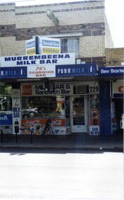
Photograph, Murrumbeena Road, 229, Murrumbeena, 2001
Originally labelled "Beauville Estate, Established 1936, Still Thriving 65 years on, 10th March 2001", the Beauville Estate Album contains colour photographs of houses in the Estate. They were taken around the time of the Beauville Estate’s 65th Heritage Celebration held on 10/03/2001 and donated to the Caulfield Historical Society shortly afterwards. Photographer unknown. From Glen Eira’s Heritage Management Plan by Andrew Ward (1996) Vol 2 p78: In Murrumbeena Road, the shops which form part of the estate are a simple cream brick row relieved by manganese bricks in bands across the upper storeys. City of Glen Eira’s Heritage Management Plan Vol 2 p79 (this is p84 of the pdf version) – HO12 Beauville Estate and environs, Murrumbeena: The Beauville Historic Area is important at the State level as the first large housing estate undertaken by the AV Jennings Construction Co, later Jennings Group Limited, Victoria’s largest home builder. It is important also as a very early estate development incorporating a range of features other than houses and including made roads, shops and recreation facilities. In this respect it was the forerunner of the comprehensively planned housing estate of the post war era. The estate is distinguished by its aesthetic values, as is the earlier and comparable Hillcrest Estate, which are formed by a combination of restrained diversity in house styles, with the exception of no. 30 in the emerging International style, and by a landscaped garden environment. Colour photograph of a section of a double storey, unpainted brick, commercial property containing shops at ground level all with awnings over the footpath. This specific property is a milk bar on street level with plate glass windows and door, colourful advertising and "229' in the top right section of the window. Shop signage says "MURREMBEENA MILK BAR". The upper storey brick residence features a large window, a flat roof and decorative two tone banded brickwork. MURREMBEENA (sic) MILK BAR / PK's / SANDWICH / BAR / MILK BAR & Sandwich Bar / 229 / SUB NEWSmurrumbeena, architectural styles, 1930's, inter war style, a.v. jennings, av jennings, jennings, beauville estate, murrumbeena road, milk bars, commercial establishments, flats, sir albert victor jennings, a v jennings construction co, beauville estate heritage area, glen eira city council, architectural features, jennings group limited, land subdivision, beauville historic area, shops, brick features, window displays, advertising signs, murrembeena (sic) milk bar -
 Glen Eira Historical Society
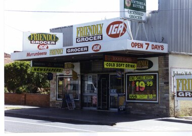
Photograph, Murrumbeena Road, 235, Murrumbeena, 2001
Originally labelled "Beauville Estate, Established 1936, Still Thriving 65 years on, 10th March 2001", the Beauville Estate Album contains colour photographs of houses in the Estate. They were taken around the time of the Beauville Estate’s 65th Heritage Celebration held on 10/03/2001 and donated to the Caulfield Historical Society shortly afterwards. Photographer unknown. No. 235 is NOT covered by the Heritage Overlay HO12.Colour photograph of a supermarket. The property features a flat roof awning, corrugated parapet, irregular multi-coloured slate tile and brick facade and extensive advertising over the front and side of the building plus on the gate to the right.Murumbeena FRIENDLY GROCER IGA / OPEN 7 DAYS / NEWSPAPERS / COLD SOFT DRINKmurrumbeena, architectural styles, 1930's, inter war style, a.v. jennings, av jennings, jennings, beauville estate, murrumbeena road, commercial establishments, shops, supermarkets, sir albert victor jennings, a v jennings construction co, beauville estate heritage area, glen eira city council, architectural features, jennings group limited, land subdivision, beauville historic area, brick shops, parapets, advertising signs, murumbeena friendly grocer iga -
 Glen Eira Historical Society
Document - NEERIM ROAD RAILWAY CROSSING AND GATES GLEN HUNTLY
This file contains two items: 1/Twelve photographs of the Glen Huntly, Neerim Road hand-operated railway gates, dated 1983 and November 1985, photographer unknown, and two black and white copies of two of the original photographs. Four photographs are in black and white and eight are in colour, all picturing the Gatekeeper’s shelter and/or the railway gates. Six photographs dated 1985 include the Gatekeeper, unidentified, in some photos operating the gates. 2/A three-page pamphlet dated 03/05/1979 promoting a public meeting at the Caulfield Town Hall to debate Road Grade Separation proposals for the Neerim Road and Glenhuntly Road railway crossings. Document details the proposed VicRail improvement and four alternative improvements as we as a blank questionnaire for the submission of ideas regarding the proposals to the Caulfield City Council Urban Planner. A short summary of other concerns held by two councillors and an engineer regarding the proposal is also included, as is a Railway Noise Level. Railway Pamphlet also includes a map of the area surrounding the railway crossings under discussion 1977.glenhuntly road, neerim road, caulfield, railway gates, gates, hand-operated railway gates, railways, roads and streets, railway crossings, architectural features, town halls, official buildings, vicrail, meetings, public meetings, caulfield town hall, gatekeepers, caulfield city council, elsternwick, glen huntly, caulfield park, caulfield racecourse, normanby road, dandenong road, railway buildings, railway stations, land transport, transport establishments, hordern a.g., dunstan don, hordern bill, needham j.g., advertisements, graphics, advertising, advertising signs, signs, estate agents, business people, stockdale and leggo, buildings structures and establishments, occupations, united signs, signs, communication devices, motor vehicles, glenhuntly railway station, town planning, civic and landscape art, engineers, professionals, traffic, road transport, transport, maps, documents, plans -
 Glen Eira Historical Society
Letter - Rosstown Railway
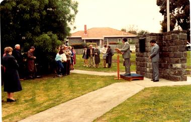
This file contains two items: 1/A group of eight letters, predominantly between Hon. Secretary of Caulfield Historical Society R. Ballantyne and members of the Caulfield City Council written between 1981 and 1983, regarding the installation of a plaque in commemoration of the centenary of the Rosstown Railway. The first two letters are handwritten from R. Ballantyne to G. Calder and Carol Camy, dated 01/06/1981 and 22/02/1982. The letter to G. Calder supports a suggestion in the May edition of the CAULFIELD CONTACT for the installation of a plaque in celebration of the centenary of the Rosstown Railway, suggesting a potential site for another plaque on Curraweena Road. The letter to Carol Harry discusses the costing of the plague and a possible contribution towards this cost from the Caulfield Historical Society. The letter appears to be incomplete, having no sign off from the author. Attached to the letter is what appears to be a suggestion for the inscription of the plaque. The letters addressed to R. Ballantyne are typed and dated 12/06/1981, 24/06/1981, 14/07/19891, 17/12/1981 and 08/09/1983, from A. Craig and D.B. Hogan on behalf of City Manager G.K. Calder and City Liason Officer Carol Harry. All letters concern the commemorative plaque, with these from Carol Harry including handwritten notes which appear to be in R. Ballantyne’s handwriting. The final letter is from Mayoral Secretary Norma Polglase to Miss B. Snowball, dated 23/08/1983, inviting her to attend the unveiling of the plaque. Also included in the item are Council Committee Meeting minutes, dated 16/05/1981, broaching the subject of installing the plaque in Koornang Road. 2/Four colour photographs and two black and white copies of one of the photographs, all dated 18/09/1983 and showing the opening of the commemorative plaque in Marrara Gardens. Two photographs picture Mayor Brian Rudski and City Manager Graham Calder with a crowd of unidentified people present. One photograph and both copies are of the inscription on the plaque, with the wording identical to that of the handwritten note by R. Ballantyne, in item one.caulfield, caulfield south, calder g.k., calder g., hawthorn road, glen eira road, ballantyne r., office workers, caulfield contact, norman peter, groups, glen huntly, koornang road, mills, sugar mills, caulfield historical society, caulfield city council, caulfield town hall, official buildings, glen huntly neville street fourteen, parliamentary representatives, rosstown, rosstown railway, rosstown railway centenary, festivals and celebrations, centenaries, historical markers, plaques, monuments and memorials, ross murray, railways, land transport, curraweena road, parts of buildings or structures, bluestone structures, construction materials, caulfield community liaison officer, harry carol, currency, finances, onley peter, elsternwick, oakleigh, council meetings, caulfield council chambers, caulfield municipal chambers, caulfield municipal offices, craig a., caulfield city manager, city of caulfield, caulfield physical environment committee, public meetings, meetings, ross james, hogan o.b., arrow engraving, campbell f., snowball miss., elsternwick gladstone parade nineteen, walters w.r., marara road gardens, marara road, marara gardens, narrawong road, ceremonies, caulfield mayors, polglase norma, mayoral secretaries, railways routes, documents, correspondence, rudski brian, calder graham, events and activities, official buildings, insignia, local government, local officials and employees, parks and reserves, buildings structures and establishments, official events, festivals and celebrations, occupations, political processes, local history, history, financial economics, local government finance -
 Glen Eira Historical Society
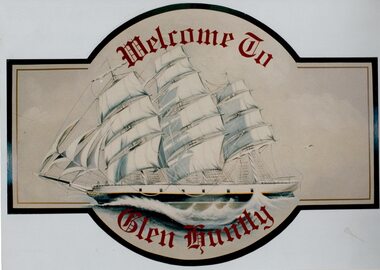
Article - GLEN HUNTLY (HISTORY OF)
This file contains 10 items about the history of Glen Huntly: 1/6 photocopied pages from ‘The History of St Kilda’ which relates to the place name Glen Huntly, and the Quarantine graves, date unknown. 2/2 photocopied pages from the ‘Sun Pictorial’ dated 13/4/1928 and 12/4/1928; relating to the state of the graves at Point Ormond and their re-internment to St Kilda Cemetery. 3/1 pen and ink sketch of graves at Point Ormond from the State Library Victoria. 4/3 pages taken from a website on the re-internment of graves and some social history as to the reason that the new emigrants were coming to Australia. The Article also has 7 photographs. 5/2 newspaper articles on the ‘Glen Huntly’ descendants forthcoming reunion being held on 21&22/4/1990. 6/1 article reprinted from newsletter no. 22 October 1983 on the barque ‘Glen Huntly’. Also details of passengers who died and the burial of 3 at Point Ormond. 7/1 handwritten document (unattributed) taken from ‘Migrant ships for South Australia 1836-1850’ by Ronald Parsons. 8/1 pamphlet commemorating the 150th anniversary of the ‘Glen Huntly’ arriving in Melbourne. It gives information about the ship, passengers, memorial in St Kilda Cemetery and upcoming descendants’ reunion. 9/1 program of commemoration events 21&22/4/1990. 10/1 piece of art work for a ‘Welcome to Glen Huntly’ sign, featuring a ship. Undated, unattributed and source unknown.‘glen huntly’, buchanan captain, fever ship, emigrants, cummins ann, st kilda cemetery, bowman mrs, caulfield, craig john, cameron miss, mcgonagle mrs, elsternwick, armstrong george, mathers james, the glen huntly pioneers memorial, jones alfred ramsey, st david’s uniting church (grange road), glen huntly, glen huntly road, lake street, glen huntly state school, glen huntly presbyterian church, south caulfield, mernda avenue, garden avenue, grange road, jenkin (boss) william, wattle avenue, chinese joss-house, smith a.w, glen huntly post office, foundation stones, king f.l, methodist church, trinity congregational church, greek orthodox church, salvation army temple, wanalta road, st anthony’s roman catholic church, st agnes’ anglican church, booran road, st david’s uniting church, el nido grove, manses, royal avenue, munster avenue, james street, rothschild street, neerim road, organs, peace memorial organ, railways, marara road, curraweena road, booran road, bambra road, rosstown railway, murray-ross william, leila road, murray-ross leila, ‘the grange’, north road, wild cherry road, ‘rosstown’, picture theatres, manchester grove, aerodrome, lord reserve, neville street, lyons street, morgan street, rosedale avenue, rifle clubs, glen huntly infant welfare centre, watson grove, rowlands drapery, drapers, bones plant nursery, nurseries, elsternwick railway station, railway stations, kooyong road, glen eira road, truganini road, rosstown sugar works, ross murray, street names, typhoid, diseases, death and dying -
 Glen Eira Historical Society
Document - History of the City of Caulfield
This file contains 4 items: 1/Typewritten document titled ‘The City of Caulfield’. Author and date unknown. 1 page (back and front), 2 copies. Document covers topics such as origins of the name ‘Caulfield’, early settlement and the Caulfield Cup. 2/Typewritten document titled ‘History of Caulfield Council’. Author and date unknown. 6 pages, 3 copies. Document covers subjects such as early settlement, Aboriginal influence, Caulfield Road Board, Shire of Caulfield, Borough and town boundaries, coat of arms, and Freedom of Entry to the City. 3/Typewritten document (undated + author unknown) titled ‘The Structure of Local Government in Victoria with a history of the City of Caulfield’. 13 pages. Covers the following subjects: Powers, Planning, Public Works, Trading Undertakings, Health Services, Municipalities, Wards Electors or Ratepayers, Voters Roll, Councillors, Officers, Finance, Nature of Soil and Vegetation, Parks and Gardens and Reserves, Coat of Arms, Boundaries, How Did Caulfield get its Name, Aboriginal Influence, Caulfield Road Board, Shire of Caulfield, Borough and Town and the City of Caulfield. Also covered is early settlement. Note at the end of the document mentions that the historical content contained in the last section was based upon a thesis for the Department of Town and Regional Planning, University of Melbourne, 1968 by L. Alwis, P. Rowe, N. Wootten. Melbourne, ‘City of Caulfield: An Illustrated City Report’. 4/Typewritten document (undated) titled ‘The Structure of Local Government in Victoria with notes on the history of the City of Caulfield’. 8 pages, 2 copies. This document also includes a map/diagram of the city with boundaries and wards showing locations of railway stations and parks. Document covers the structure of local government and its functions then goes on to focus on City of Caulfield with subjects similar to those covered in item 3. Document signed off by Deputy Town Clerk.city of caulfield, caulfield john, caulfield baron, caulfield racecourse, elsternwick, ripponlea, st. mary’s church, caulfield council, kooyong road, neerim road, bambra road, greenmeadows house, caulfield park, paddy’s swamp, dandenong road, caulfield grammar school, chisholm institute of technology, murrumbeena, glen eira road, alma road, orrong road, balaclava road, inkerman road, ‘grosmont’, caulfield school room, caulfield road board, caulfield road district, crimean war, victorian amateur turf club, caulfield cup, glenhuntly road, north road, glenhuntly station, ormond station, outer circle railway, local government, gardenvale, carnegie, rosstown, poath road, nepean highway, hotham street, ormond park, princes park, ross william murray, caulfield institute of technology, ‘ross’ folly’, hawthorn road, glenhuntly, ormond, morris t. w., lloyd charles du plan, meals on wheels, shire of caulfield, caulfield railway station, caulfield rsl, bouran road, murrum murrumbeen, kooyong road, great dandenong road, neerim road, trams, prahran and malvern tramways trust, fisher andrew, mackinnon reserve, dover street, ‘glen eira’, blair max cr., insignia, third ordnance services unit, schools, street lighting, lampriere, mr. bevan, the caulfield leader, davies j. henry, curraweena road, st. georges road, o’neill college, hope george, market gardens, koornang reserve, packer reserve, murrumbeena reserve, hopetoun gardens, greenmeadows gardens, mirambeena, caulfield technical college, hart john, langdon h. j., ‘rosecraddock’, judge webb, ‘crotonhurst’, service james, ‘kilwinning’, ricketson henry, grimwade frederick sheppard, airdrie, jenner, st. aubin’s, caulfield john p. t., harlston, lempriere, lord reserve, ‘cantala’ -
Glen Eira Historical Society
Article - St Pauls Anglican Church, 530 Dandenong Road, Caulfield North
Two Port Philip Leader articles on the Rev Howard Langmead. His talents as a comedien and acknowledgement of the church’s Billboard sign, which is causing a lot of interest, locally and interstate. Date unknown. Includes two colour photographs.caulfield, billboards, st pauls anglican church, comedians., langmead howard rev., st clements anglican church, dandenong road, brighton road, caulfield north, elsternwick -
Glen Eira Historical Society
Article - ELSTERNWICK RAILWAY STATION AND LINE
Contains three items about this: 1/A photocopied article (across 3 long columns) from the Southern Cross newspaper dated 21/07/1928. The article contains details of the opening of the Gardenvale Martin Street subway ceremony. Mention is made of the Caulfield Council’s spontaneous assistance, harmony working alongside Brighton and their financial assistance, as well. Councillor E.F. England (Mayor of Caulfield) attended on behalf of the Caulfield Council. He referred to the large patronage on the Brighton line, also mentioning similar issues for the Elsternwick level crossing. There are brief summaries from the many speakers. The pupils from Gardenvale and Elsternwick schools were congregated around the subway, and the Brighton municipal Brass Band rendered selections. 2/Newspaper clipping (source not stated perhaps Melbourne Sun), ‘Elsternwick to get underpass’, dated 25/02/1959, stating that ‘work has begun to build an underpass that will abolish the Glenhuntly Road level crossing’, with photograph and a map of the level crossing. 3/Handwritten note, signed ‘FEC, 17/11/2006’, headed ‘To be researched – Shooting in foot underpass-policeman killed-murder last man to be hanged in Victoria’, with note on Glenhuntly Road underpass.‘southern cross’, gardenvale progress league, point nepean road, newspapers, caulfield council, north road, ‘made in australia’ week, railways department, parliamentary representative, railway crossings, councillors, gardenvale school, elsternwick school, schools, market gardens, gardenvale progress association, england e.f.(mayor), elsternwick, caulfield, hoyts theatre, theatres, glenhuntly road, elsternwick station, police, murders, executions, shops, elsternwick plaza, petrol stations, ‘the hub’, flats, brothels, ‘the daily planet’ (sic), car parks -
Glen Eira Historical Society
Document - ORMOND IN THE TWENTIES, WITH PARTICULAR REFERENCE TO THE ORMOND PARK CRICKET CLUB, BY CYRIL H. HENSHAW
Typescript text of a talk given to the Caulfield Historical Society on Wednesday, 17 June 1981, by Cyril H. Henshaw. 20 single-sided sheets bound in binder, plus two additional sheets (addendum) separately, in polyester sleeve (typescript, signed C. Henshaw in ink.) Note: Despite the title, this talk contains so much material pertaining to the history of Ormond that it has been filed and catalogued to reflect that, rather than being filed with material relating to the cricket club.ormond cricket club, ormond park cricket club, ormond state school, ormond junior presbyterian cricket club, ormond katandra road 20, ormond katandra road 26, ormond katandra road 30, history of ormond, rosstown railway, henshaw cyril h., sporting clubs, ormond railway station, briggs james r., lord harry, dawson eileen (mrs. rae), rae eileen (nee dawson), lord edwin, lord allan, lord estate agent (katandra road 8 north road ormond, outhred keith, jones hugh rev., jones lorna, arundel e. (ted), nutt e., stock w.g. (george), caulfield eumeralla road, ormond wheatley road, ormond north road, ormond murray road, ormond park (e.e. gunn reserve), e.e. gunn reserve, presbyterian church hall (fraser street and north road ormond), ormond plant farm, queen’s hall caulfield, stock len, ormond presbyterian cricket club, ellis harry, coulsons mac, jones w. sergeant, jones bill, ashton r., mclean a., ellis r., de garis mr., whitelaw’s cafe (dalmor avenue & north road ormond), gunn e.e., russell mr. & mrs., ormond picture theatre (north road ormond), ormond park committee, stock lilian mrs., morgan w. rev., cohn alan, livesey miss, riley miss, birch f., laver lloyd -
Glen Eira Historical Society
Article - Grand Union Tramway Junction, Balaclava Road and Hawthorn Road
This file contains three items. 1. A three-page Caulfield Conservation Study of the Balaclava Road/Hawthorn Road Tramway Crossing, undertake by Andrew Ward and dated September 1994. Study includes a brief history of the junction and a statement of significance. Study also includes Four black and white photographs of the junction and of architectural details of the tram tracks. 2. A letter from the Conservation Manager of the National Trust of Australia (Victoria) to the manager of the Planning Section for the City of Glen Eira, dated 15/06/2001 and attached to a six-page Classification Report. The letter informs of the Classification of the Grand Union Junction at the intersection of Balaclava and Hawthorn Road by the national trust, signed by Conservation Manager Ian Pausacker. Classification Report includes details such as the date of construction, a statement of significance, history of the junction, physical description of the junction and the condition of the junction at the time of writing. Report also includes a map of the Melbourne Tram Network drafted by Keith Kings and dated 01/005/1956, with illustration of the layout of fifteen tram depots, and updated aerial illustration of the Grand Union Junction, and a further map of Melbourne Tramways developed by North Melbourne Electric Tramways and Lighting Co. and Prahran and Malvern Tramways Trust, drafted by Keith Kings and dated January 1914 with illustrations of three tram depots. 3. Two articles from the Caulfield Leader written by Aaron Langmaid and dated 13/02/2007 and the Melbourne Bayside Weekly dated 21/02/2007 written by Joanne Sim, both concerning the Grand Union Junction. The article from the Caulfield Leader includes a picture of Executive Officer of the council of Tramway Museum of Australia Craig Tooke in front of the intersection. The article from the Bayside Weekly includes a picture of a tram passing through the junction and a brief history of the junction and tram network in Caulfield. The article also refers to twp local tram shelters at the intersection of Dandenong Road and Alma Road and also Orrong Road and Balaclava Road.caulfield, caulfield conservation, study, balaclava road, hawthorn road, grand union junction, ward andrew, tramway crossings, transport, acland street, caulfield racecourse, tram tracks, race events, event, tram routes, thorough fares, melbourne and metropolitan tramways board, prahran and malvern tramway trust, prahran and malvern district tramways, caulfield electric tramways, caulfield city council, architectural detail, city of glen eira, balaclava road and hawthorn road intersection, balaclava road and hawthorn road junction, dandenong road, glenhuntly road, four-way tram junctions, access covers darling road, cast metal access covers, hadfields patent, caulfield park, tram systems, tram networks, heritage, tramway heritage, kings keith, tram depots, glenhuntly depot, maps, glen eira, melbourne electric tramways, north melbourne electric tramways and lighting co., prahran and malvern tramways trust, caulfield leader, bayside weekly, tooke craig, tourist attractions, grand union tramways junction, caulfield junction, cable car tramways, tram shelters, building, sheds, alma road, orrong road, caulfield electric line, balaclava junction, elsternwick railway station, caulfield station, caulfield station loop, tram services, transport establishments, thoroughfares, buildings, structures, establishments, parts of buildings or structures, documents, commercial industry, sites, historic sites, melbourne bayside weekly -
 Glen Eira Historical Society
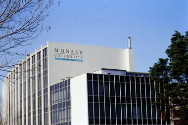
Article - MONASH UNIVERSITY CAULFIELD CAMPUS
This folder contains 6 items about this educational institution: 1/Undated colour slides showing various angles of two different building facades of Monash Caulfield Campus. 2/Article 'Martens Matters' re launch of exhibition of covesr of OASE 33 Magazine by Designer Karel Martens. Date noted as 01/04/2011 in 'The Age'. 3/Collection of 6 separate cards, all Priority Development Panel Submissions, Design Visualization, dated May 2006 (Architectural drafts) dated 31/03/2006 plus 2 identical cards dated 01/05/2006 - all drawings and one plan for NHArchitecture. 4/Collection of 4 colour separate cards, all Priority Development Panel Submissions, Design Visualization for Architect Wojciech Huszek of existing buildingsdated 31/03/2006. 5/Collection of 4 colour separate cards all Priority Development Panel Submissions, Design Visualization of existing buildings by photographer Andrius Lipsys, dated March 2006. (No architect stated.) 6/Article 'Uni rank sign of the Times' from Glen Eira Port Phillip Leader dated 12/03/2013 concerning Monash University’s world ranking in 100 best universities.nharchitecture, altoon and porter (master planner and urban designer ), huczek wojciech (architect), lipsys andrius (photographer), martens karel, station square development, campus map, derby lane, princess lane, post office place, caulfield station, sir john monash drive, derby road, the hub, the mat, post office square, station square, zagame’s hotel, dandenong road, oase 33, art and design building, monash university, caulfield campus, caulfield east, universities, tertiary education -
 Flagstaff Hill Maritime Museum and Village
Functional object - Ship's Wheel
This wooden ship's wheel originally had eight spokes but four are no longer in their sockets. One of the spokes has been shaped. Both sides of the wheel have a brass cap over the centre of the hub, covering the wooden hub. The wood is split and cracked, and parts of it have small holes, a sign of being affected by the sea worm. Thick encrustations are on parts of the wheel, showing that it has been on the sea bed for quite some time. The donor is a Warrnambool resident. Years ago he was cray fishing at King Island, which is in Bass Strait, northwest of Tasmania. His craypot got stuck in a reef so a diver helped him by retrieving the craypot for him. While the diver was underwater he also stumbled across the ship's wheel, which he gave to the donor. The Bass Strait is a very narrow route that was difficult and dangerous to navigate in the early 19th century, before good maps, communications and lighthouses were installed. The area, including King Island, is the graveyard of many ships that almost made it to their destination of Melbourne along Australia's treacherous coastline. Around King Island alone, many ships and lives were lost. There is no information about the history of this ship's wheel. Its condition shows that the item has been under the water for a long time. However, there is no evidence that it came from a shipwreck. It could even have been an old ship that could have been scuttled or destroyed as it was no longer useful. The wheel is significant as a sign of shipping around King Island. It is part of the island's history, and of maritime history. It is an example of an item manufactured by hand.Ship's wheel; segment of a wooden ship's wheel. It once had eight spokes but only portions of four spokes remain. The outer centres of the hub and the reinforcing bands around the hub are brass. The wheel is heavily encrusted in parts. It was recovered from an unknown shipwreck in the waters of King Island.great ocean road, warrnambool, shipwreck artefact, artefact, ship's wheel, ship's wheel segment, portion of a ship's wheel, flagstaff hill, maritime museum, maritime village, flagstaff hill divers, marine technology, navigation, steering wheel, eight spoke wheel, king island, craypot, diver -
 Federation University Historical Collection
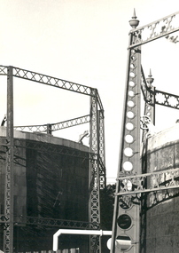
Photograph - Photograph - Black and White, Geoff Biddington, Views of Ballarat, 1967
These images were taken by Geoff Biddington who was highly active in the Ballarat Branch of the National Trust. Twenty two black and white photographic views of Ballarat by Geoff Biddington. 1. Ballarat Mechanics' Institute 2. 18-20 Lyons Street south, Ballarat 3. Licensed grocer (Corner Eyre and Lyons Street South) featuring Ballarat Bertie Sign 4. Cast Iron Gasometer Frames 5. Former Ballarat Supreme Court (Ballarat School of Mines Electrical Engineering 6. Telegraph Station (Castlemaine?) 7. Ballarat Fine Art Gallery (later Art Gallery of Ballarat) 8. Former Ballarat Police Station, Camp Street 9. Former Baptist Church, Dawson Street 10. Craig's Hotel Lamp 11-13. Goller's, Camp Street 14. Old Post Box- Crown on Top 15. Former Ballarat Gaol Gates 16. Golden Point Football Club Rooms, Main Road 17. Ballarat Fire Station, Ballarat East 18. Ballarat Town Hall Tower 19. Ballan Hotel 20. Building on Inglis street, Ballan 21. Ballan News Building (Est 1872) 22. Adam Lindsay Gordon Cottagebiddington, ballarat mechanics' institute, ballaarat mechanics' institute, mechanics institute, gasometer, ballarat police station, police, baptist church, craig's hotel, goller, post box, crown, golden point, ballarat town hall, ballan hotel, adam lindsay gordon cottage, ballarat gaol gates, wrought iron, bluestone, ballarat bertie, orlando, penfolds, signwriting, licensed grover, ballarat bitter, craig's royal hotel lamp, craig's hotel -
 Flagstaff Hill Maritime Museum and Village
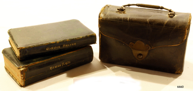
Book - Religious books in case, Book of Common Prayer and Hymns Ancient and Modern, Mid 19th century
In the words of the Donor, Betty Stone, "According to family tradition, this small leather case containing a prayer book and a hymn book was originally owned by Susan (nee Ellis) Chamberlain who brought it with her when the family left Thriplow England in 1854 to come to Australia. Later, Susan passed it on to her granddaughter Ann (nee Lees) Dale who used the little books for some years in 1912, Ann Dale (my grandmother) gave the case and books to my mother Daisy Elvena Dale. Daisy, aged twelve years at the time, was the youngest child of Ann and Ellis Dale, of Latrigg, Wangoom, Warrnambool. There is no date of publication but it would be mid-1800's, as it was brought to Australia in 1854 . The hymn book has a notation - “From Mother to Daisy 1912 Print too small” and is signed by A. Dale. (ie Ann Dale, granddaughter of Susan Chamberlain)" (Note: For additional information please refer to Betty Stone’s book “Pioneers and Places - A History of three Warrnambool Pioneering Families” ie. Chamberlain, Dale and Lees Families) This item is associated with families of Chamberlain, Dale and Lees. These families are listed in the "Pioneers' Register" for Warrnambool Township and Shire, 1835-1900, published by A.I.G.S. Warrnambool Branch.Miniature leather case with two books inside - Book of Common Prayer and Hymns Ancient and Modern, Brought to Australia by Susan Chamberlain when she emigrated in 1854. From the 'Chamberlain Dale Lees Collection'. Hand written inscription is inside the cover. One end of the handle has been repaired by sewing it in place. Hand written inside the cover is "From Mother to Daisy, 1912 Print too small (signed) A. Dale"flagstaff hill, warrnambool, shipwrecked coast, flagstaff hill maritime museum, maritime museum, shipwreck coast, flagstaff hill maritime village, great ocean road, chamberlain, dale, lees, stone, betty stone, warrnambool pioneers, miniature bible, miniature hymn book, worship, emigration -
 Flagstaff Hill Maritime Museum and Village
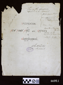
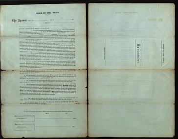
Legal record - Plans and Contract, Arthur H. Cutler, Architect, Warrnambool Town Hall, 1890-1892
This is a set of documents including three sheets of blueprint plans for the New Town Hall and Offices for Warrnambool, created in 1890 by the Architect Mr Arthur H. Cutler of Melbourne. The Contract was signed by the Town Mayor for Warrnambool, Mr William Simpson on May 7th 1890. Also, a Council copy of the Contract dated 26 June 1890, with the signatures and diagram where the two official stamps would be placed. The Foundation Stone was laid the following year by the next Mayor, John Hyland on February 24th 1891. The contractor for the building was granted to W. Kellas (William) of Warrnambool. The Town Hall and Offices were built on the corner of Liebig and Timor Streets in Warrnambool. On March 20th 1983 the new Performing Arts Centre was opened y the Mayor, Councillor R w Andreson, on the same site. The new building incorporates the 1890 Town Hall building. The plans, contracts, documents and various references to people on the documents are significant to the history of the City of Warrnambool and its community. The Warrnambool Town Hall building is also significant for the many community events held there over the decades after it was built. Appreciation for the significance of the almost century-old Town Hall building is demonstrated by its inclusion in the new Performing Arts Centre.Set of five documents that includes Plans for the Warrnambool Town Hall, the Contract cover page and a letter from the Architect to the Council. The Contract cover page and the Letter are hand written on cream-coloured paper with a waxy finish, with watermarks. 1) Contract Cover Page, 5th May 1890, Specification of the New Town Hall and Offices at Warrnambool. 2) Letter, 29th January 1892, from Architect Arthur H. Cutler to Mayor and Councilors, Town of Warrnambool 3) Blueprint Sheet 4, Longitudinal Section, and profiles of Liebig Street and Timor Street, Warrnambool Town Hall, 4) Blueprint Sheet 3, First Floor & Balcony Plan, and Roof Plan 5) Blueprint Sheet 2, Ground Floor Plan, Warrnambool Town Hall 6) Contract, 26 June 1890, marked (Draft Copy Tow Hall Contract), Between Mayor, Councillors and Rate Payers, and William Kellas, ContractorWatermarks on handwritten pages [horizontal lines], "36" "BUSBRIDGE'S / LOFT DRIED" Contract cover page, Oval stamp "CUTLER - 281 COLLINS ST. E. MELBOURNE - ARCHITECT " (other crossed out text) Handwritten script "This is the specifications referred to in our agreement" "Dated this 7th day of May A.D. 1890" Signed "W. Simpson Mayor" "Arthur H. Cutler Architect", [two Witnesses' signatures and others] Letter from Arthur Cutler, handwritten, has his address "472 Chancery Lane, Melbourne" CONTRACT of 26 June 1890: "The Mayor, Councillors and Rate Payers of Warrnambool" "William Kellas of Warrnambool" "Signed William Simpson, Maoyorr" "R F Kennedy, Councillor" "Wm Kellas" with diagrams where the round Common Seal and square Stamp would be applied.warrnambool, flagstaff hill, warrnambool, flagstaff hill maritime museum, maritime village, shipwreck coast, great ocean roaad, warrnamboo town hall, warrnambool council offices, mayor william simpson, arthur h cutler, architect, civic centre, town hall, performing arts centre, mayor john hyland, william kellas, mayor r w anderson, r f kennedy, contract -
 Federation University Historical Collection
Document, A.J. Peacock, Agreement under the Mines Act 1890, 13/02/1919
Richard Squire was a graduate of the Ballarat School of Mines. He worked a number of mines in Victoria..1) Large legal document under the Miners Act 1890 Part 2, between Allan A. Fraser of Meredith and Richard Brereton Squire of 66 Lewisham Road Windsor, Victoria. A seal has been attached to the two signatures. .2) blank formSigned by Allan A. Fraser and Richard B. Squire. Both signatures witnessed by Annie Marchment.mining, mines act, mines act 1890, squire, richard squire, fraser, marchment, annie marchment, meredith, windsor, grenville, lalalute -
Federation University Historical Collection
Document - Report, University of Ballarat Canadian Wetlands Project Report, 2000, 04/2000
1992 - Property purchased fronting Geelong Road, Mount Helen 1994 - Additional adjoining property purchased 1995 - Wetlands included in the Corporate Plan for the area 1997 - Launch of Wetlands Development by Minister Maclennan 1998 - Preliminary planning and plant identification underway - Contract signed for funding 1999 - Stage 1; Planning finalised, earthworks undertaken and weed infestation assaulted - "Work for the Dole" project undertaken - Deluge of rain on Boxing Day provides the centrepiece f the project, the just-completed dam, with a body of water to overflowing level. - Waterbirds move in and the germination of native wetland plant species begins 2000 - Stage 2 plans developed, including additional walkways, bird hides and interpretation. Three page report on the University of Ballarat Canadian Wetlands Project. Direct funding for the project was provided by the University of Ballarat; The Department of Employment, Workplace Relations and Small Business and the Corangamite Catchment Authority.ballarat technology park, canadian wetlands, ian howe, mount helen, mount helen campus -
 Federation University Historical Collection
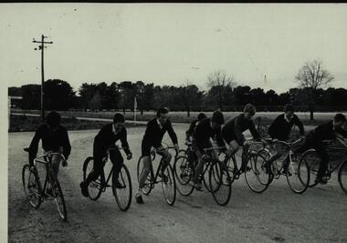
Photograph - Black and white photograph, Bike Ride - Ballarat Technical School students - 1950s
... .1 Black and white photograph of on bicycles. Sign on LHS... Black and white photograph of on bicycles. Sign on LHS "Ballarat ....1 Black and white photograph of on bicycles. Sign on LHS "Ballarat 3" (miles). Second sign is train crossing sign for private road. .2 Riding on made road with channel dug beside. Farming area..1 "Ilford"; 1746 stamped. Hand written 9 .2 "Ilford"; 1748 stamped. Hand written 10bicycle, cyclist, ballarat junior technical school -
Federation University Historical Collection
Poster - Signs, Window signs by Keith Rash
It is thought the signs were used for Ballarat's Gold Centenary in 1851.Seven window signs by Keith Rash painted onto wallpaper. The signs were designed to sit in shop windows to tell the history of the shop of company. .1) In 1862 Eurgene Bourdet conducted the "Imperial Dining Rooms" here. Board 20/- Board & Lodging 25/- week .2) On 16th Feb. 1853 at the Government Land Sale, Mr C.N. Thorne purchased this area. In 1893, R. Ludbrook used this property as Auction Rooms. .3) McArtney & aldred first occupied these premises in 1856. There were coachbuilders. .4) From the Single Storeyed wooden building once her J.P. Clarke operated as a carrier until 1865. Welsh & Surplice took over as Estate Agents until 1870. .5) Dr James Stewart built this property H.G. Harrison, 1957. J.C. Proctor 1862, John Stokes 1865, were chemists here. In 1856 The Savings Bank commenced here. W.H. Pooley, actuary .6) Wm Moss, tinsmith, occupied this site in 1865. Thos. Freeman,a uctioneer in 1882. .7) Doig & Cant. Gasfitters & Plumbers came here from Main Road in 1866. After 38 years A. Cant removed 2 doors further north .8) In 1871, This part was the shop of Wm Moss, tinsmith & plumberballarat, doig, cant, plumber, william moss, tinsmith, thomas freeman, james stewart, h.g. harrison, j.c. proctor, john stokes, savings bank, w.h. pooley, j.p. clarke, welsh, surplice, mcartney, aldred, coachbuilders, c.n. thorne, r. ludbrook, eugene bourdet -
 Flagstaff Hill Maritime Museum and Village
Painting - Maritime painting, 1837
Research is currently being undertaken on this maritime painting.Painting behind glass, depicting P & O ship WILLIAM FAWCETT. Gold painted frame, gold matte. Signed N. P. Wilkinson ("on" at end of signature is obscured by matte). Inscriptions on back paper of frame. Signature on bottom right "N.P. WILKINSO - - " is partly obscured by the gold matte that covers the last letters "ON". (is artist Norman Wilkinson?) Inscription on paper on back of painting has pencil writing "24-ID 3/4/905" Also has a white sticker with pen writing "55"flagstaff hill, warrnambool, flagstaff-hill, flagstaff-hill-maritime-museum, maritime-museum, shipwreck-coast, flagstaff-hill-maritime-village, painting, norman wilkinson, n wilkinson, n p wilkinson, william fawcett, p & o ship -
 Flagstaff Hill Maritime Museum and Village
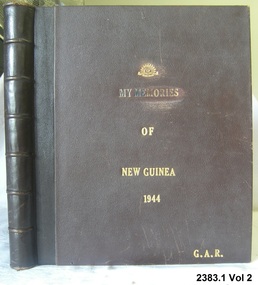
Book, My Memories of New Guinea 1944 Vol 2, after 1944
Books, one of a set of two, "My Memories of New Guinea 1944 Vol 2". Leather bound books with gold lettering ("My Memories" lettering shows signs of wear). The bottom right corner of the cover has embossed in gold the initials “G.A.R." This book contain newspaper cuttings, pictures and hand written notes on various ships and shipping disasters.gold lettering on cover "G.A.R."flagstaff hill, warrnambool, shipwrecked-coast, flagstaff-hill, flagstaff-hill-maritime-museum, maritime-museum, shipwreck-coast, flagstaff-hill-maritime-village, my memories of new guinea 1944 vol 2, book -
 Flagstaff Hill Maritime Museum and Village
Painting - Maritime painting, C. W. Veale, Loch Ard, c. 1978
This painting is believed to have been created by an amateur artist C W Veale of Colac, who established an early bus service in about 1923, known at the time as the Blue Bus Service, which operated from Colac. This service was available for special trips within the Colac region. The Blue Bus Service became very popular with travellers to Lorne via the Deans Marsh Road. The label on the back of the painting comments on whether the ship would be in full sail at the time of the wreck. History of the Loch Ard: The Loch Ard got its name from "Loch Ard" a loch that lies to the west of Aberfoyle, and the east of Loch Lomond. It means "high lake" in Scottish Gaelic. The vessel belonged to the famous Loch Line which sailed many vessels from England to Australia. The Loch Ard was built in Glasgow by Barclay, Curle & Co. in 1873, the vessel was a three-masted square-rigged iron sailing ship that measured 79.87 meters in length, 11.58 m in width, and 7 m in depth with a gross tonnage of 1693 tons with a mainmast that measured a massive 45.7 m in height. Loch Ard made three trips to Australia and one trip to Calcutta before its fateful voyage. Loch Ard left England on March 2, 1878, under the command of 29-year-old Captain Gibbs, who was newly married. The ship was bound for Melbourne with a crew of 37, plus 17 passengers. The general cargo reflected the affluence of Melbourne at the time. Onboard were straw hats, umbrellas, perfumes, clay pipes, pianos, clocks, confectionery, linen, and candles, as well as a heavier load of railway irons, cement, lead, and copper. There were other items included that were intended for display in the Melbourne International Exhibition of 1880. The voyage to Port Phillip was long but uneventful. Then at 3 am on June 1, 1878, Captain Gibbs was expecting to see land. But the Loch Ard was running into a fog which greatly reduced visibility. Captain Gibbs was becoming anxious as there was no sign of land or the Cape Otway lighthouse. At 4 am the fog lifted and a lookout aloft announced that he could see breakers. The sheer cliffs of Victoria's west coast came into view, and Captain Gibbs realised that the ship was much closer to them than expected. He ordered as much sail to be set as time would permit and then attempted to steer the vessel out to sea. On coming head-on into the wind, the ship lost momentum, the sails fell limp and Loch Ard's bow swung back towards land. Gibbs then ordered the anchors to be released in an attempt to hold their position. The anchors sank some 50 fathoms - but did not hold. By this time the ship was among the breakers and the tall cliffs of Mutton Bird Island rose behind. Just half a mile from the coast, the ship's bow was suddenly pulled around by the anchor. The captain tried to tack out to sea, but the ship struck a reef at the base of Mutton Bird Island, near Port Campbell. Waves subsequently broke over the ship and the top deck became loosened from the hull. The masts and rigging came crashing down knocking passengers and crew overboard. When a lifeboat was finally launched, it crashed into the side of Loch Ard and capsized. Tom Pearce, who had launched the boat, managed to cling to its overturned hull and shelter beneath it. He drifted out to sea and then on the flood tide came into what is now known as Loch Ard Gorge. He swam to shore, bruised and dazed, and found a cave in which to shelter. Some of the crew stayed below deck to shelter from the falling rigging but drowned when the ship slipped off the reef into deeper water. Eva Carmichael a passenger had raced onto the deck to find out what was happening only to be confronted by towering cliffs looming above the stricken ship. In all the chaos, Captain Gibbs grabbed Eva and said, "If you are saved Eva, let my dear wife know that I died like a sailor". That was the last Eva Carmichael saw of the captain. She was swept off the ship by a huge wave. Eva saw Tom Pearce on a small rocky beach and yelled to attract his attention. He dived in and swam to the exhausted woman and dragged her to shore. He took her to the cave and broke the open case of brandy that had washed up on the beach. He opened a bottle to revive the unconscious woman. A few hours later Tom scaled a cliff in search of help. He followed hoof prints and came by chance upon two men from nearby Glenample Station three and a half miles away. In a complete state of exhaustion, he told the men of the tragedy. Tom then returned to the gorge while the two men rode back to the station to get help. By the time they reached Loch Ard Gorge, it was cold and dark. The two shipwreck survivors were taken to Glenample Station to recover. Eva stayed at the station for six weeks before returning to Ireland by steamship. In Melbourne, Tom Pearce received a hero's welcome. He was presented with the first gold medal of the Royal Humane Society of Victoria and a £1000 cheque from the Victorian Government. Concerts were performed to honour the young man's bravery and to raise money for those who lost families in the disaster. Of the 54 crew members and passengers on board, only two survived: the apprentice, Tom Pearce, and the young woman passenger, Eva Carmichael, who lost her family in the tragedy. Ten days after the Loch Ard tragedy, salvage rights to the wreck were sold at auction for £2,120. Cargo valued at £3,000 was salvaged and placed on the beach, but most washed back into the sea when another storm developed. The wreck of Loch Ard still lies at the base of Mutton Bird Island. Much of the cargo has now been salvaged and some items were washed up into Loch Ard Gorge. Cargo and artefacts have also been illegally salvaged over many years before protective legislation was introduced in March 1982. One of the most unlikely pieces of cargo to have survived the shipwreck was a Minton majolica peacock- one of only nine in the world. The peacock was destined for the Melbourne 1880 International Exhibition. It had been well packed, which gave it adequate protection during the violent storm. Today the Minton peacock can be seen at the Flagstaff Hill Maritime Museum in Warrnambool. From Australia's most dramatic shipwreck it has now become Australia's most valuable shipwreck artefact and is one of very few 'objects' on the Victorian State Heritage Register.The shipwreck of the Loch Ard is of significance for Victoria and is registered on the Victorian Heritage Register ( S 417). Flagstaff Hill has a varied collection of artefacts from Loch Ard and its collection is significant for being one of the largest accumulation of artefacts from this notable Victorian shipwreck of which the subject items are a small part. The collection's objects give us a snapshot of how we can interpret the story of this tragic event. The collection is also archaeologically significant as it represents aspects of Victoria's shipping history that allows us to interpret Victoria's social and historical themes of the time. Through is associated with the worst and best-known shipwreck in Victoria's history.Painting in brown-stained wooden frame. Depicts three-masted vessel 'Loch Ard' in full sail on moderate seas. Ship has figurehead, figures on board, and a Union Jack flag on red background. Ship's hull is black with white stripe, and is red on waterline. Ship's name is on hull. Artist C. W. Veale, painted in 1978, signed on bottom right. Label on back of painting has typed description of the Loch Ard and a comment.Signature "C W Veale / 1978" Text on hull "LOCH ARD" Label on back; " "LOCH ARD" / The clipper ship Loch Ard was wrecked on the 1st June 1878. / Of 54 people on board only two survived : Eva Carmichael and Tom Pearce. / Pearce became hero of the wreck for saving Miss Carmichael. / This picture shows the Loch Ard in full sail in moderate seas. / When approaching Cape Otway from the west, she would be in rough water and would presumably not be in full sail."flagstaff hill maritime museum, colac bus services, blue bus service, cw veale, loch ard paintings, loch ard, veale, warrnambool, great ocean road, eva carmichael, tom pearce, thomas pearce, cape otway, cargo ship 1878 -
 Flagstaff Hill Maritime Museum and Village
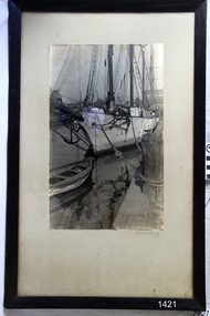
Photograph
Photograph of schooner "RA*RA" docked. Signed - N.P.Wilkinson 1928flagstaff hill, warrnambool, shipwrecked-coast, flagstaff-hill, flagstaff-hill-maritime-museum, maritime-museum, shipwreck-coast, flagstaff-hill-maritime-village, photograph, n.p.wilkinson -
 Flagstaff Hill Maritime Museum and Village
Legal record - Record Book, Warrnambool Lighthouse Register of Meteorological Observations 1902 Jan
flagstaff hill, warrnambool, shipwrecked-coast, flagstaff-hill, flagstaff-hill-maritime-museum, maritime-museum, shipwreck-coast, flagstaff-hill-maritime-village, warrnambool lighthouse register of meteorological observations 1902 Jan, meteorological observations, book, Warrnambool Lighthouse, Meteorological ObservationWarrnambool Lighthouse Register of Meteorological Observations 1902 Jan Handwritten entries in columns of Air Pressure, Temperature, Wind Velocity and Direction, Cloud, Rain and Remarks, Signed D Lindsayflagstaff hill, warrnambool, shipwrecked-coast, flagstaff-hill, flagstaff-hill-maritime-museum, maritime-museum, shipwreck-coast, flagstaff-hill-maritime-village, meteorological observations, book, warrnambool lighthouse, meteorological observation, warrnambool lighthouse register of meteorological observations 1902 jan -
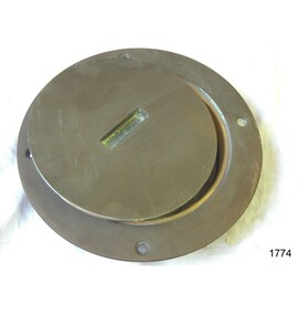 Flagstaff Hill Maritime Museum and Village
Functional object - Inspection Plate, Mid-20th century
This cast brass deck inspection cover with housing is made for the marine environment. Inspection plates have been incorporated into the ship's design since at least the late 19th century. Modern deck inspection posts have a similar design and can be made from stainless steel, aluminium or plastic. The deck inspection plate gives marine vessel owners and inspectors easy access to the areas below the deck to check for signs of damage, wear or corrosion. This mid-20th-century inspection plate with housing shows the importance of marine safety. Inspections on marine vessels today are still carried out via inspection ports made from modern materials. Inspection plate; a round brass marine inspection screw-out cover and housing with a slotted recess in the lid.warrnambool, shipwreck coast, flagstaff hill, flagstaff hill maritime museum, flagstaff hill maritime village, brass marine inspection plate, marine equipment, inspection housing, boat plate, inspection port, marine plate, deck plate, marine safety -
 Flagstaff Hill Maritime Museum and Village
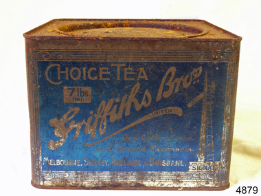
Container, Griffiths Bros, 1900 - 1940
In 1873, English grocer James Griffiths migrated to Melbourne with his wife and cousin in order to start a tea business. By 1875 Griffiths Brothers Teas had become a sensation, providing tea, coffee, cocoa and chocolate all over Australia. The Sydney outlet of the Melbourne-based company was built in 1915. In a memorable advertising campaign, a series of Griffiths signs were situated at varying intervals along the rail lines on fences and building, designed to allow travellers to count down the miles until they could drink up. In 1925, James Griffiths was killed by a train and the tea company was sold to Robur Tea, which itself lasted until 1974. Griffiths’ death meant downsizing within the company with the Sydney building being transferred to the Sydney City Council, who then leased it back to Griffiths Teas. The tea craze was over by 1965, and Griffiths relinquished control of the building to a variety of tenants. Griffiths tea became an intrical part of Australian life, during the late 19th to mid 20th century. The company became a household name through the clever use of outdoor advertising with their blue and white enamel “Griffiths Tea” signs. These were visible Australia wide on railway fences, stations and other buildings. Griffiths signs let the rail travelers know the distance to where their tea could be enjoyed, with distances being shown as “miles to Griffiths Tea”, These signs were well known along the eastern states railway lines. Tea container tin Griffiths blue tin with round lid, not hinged. 7lbs net Choice Tea Griffith Bros 7lb net in white on a blue labelflagstaff hill, warrnambool, shipwrecked-coast, flagstaff-hill, flagstaff-hill-maritime-museum, maritime-museum, shipwreck-coast, flagstaff-hill-maritime-village -
 Flagstaff Hill Maritime Museum and Village
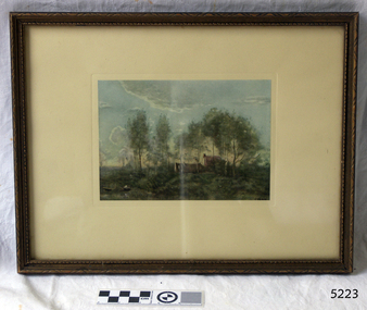
Print - Landscape, Jean Baptiste Camille Corot, Souvenir of a Journey to Coubron, 1908-mid-20th century
Famous French artist Jean Baptiste Camille Corot, 1796-1875, was trained in the classical landscape style. His inspiration came from his travels around France and Italy. He developed a soft poetic or romantic style of work which became very popular. He had the skills to bring'light' into his paintings. The original oil on canvas painting by Corot is held at The National Gallery in the United Kingdom. It is titled 'Souvenir of a Journey to Coubron' and is one of twenty-seven of his works at the Gallery. Corot visited Coubon, east of Paris, many times. In 1873 during his stay there he sketched the scene that became the basis of this painting. This reproduction print was made by The Medici Society Ltd., founded in England 1908. The Society's aim was to make artwork affordable and available to the general public. The name Medici was chosen to honour the support and encouragement given to artists in the 15th century by Lorenzo de' Medici (1449 - 1492), known as Lorenzo the Magnificent, and his family. His profile is on the company's trademark. The Medici Society still produces Fine Art reproduction prints as well as selling original works. The print was framed by Westminster Art Gallery in Camperdown, London. The handwritten text on the back of the artwork adds some background to the artist: Corot was apprenticed to a Draper but changed to his profession at the age of 22 years. When he went from a poor artist to achieving wealth and fame he generously supported his less fortunate fellow artists. Corot found that the light and shade in a natural scene meant more to a landscape painter that what could be learned by following the principles of the academies. Corot was 51 years old before he sold his first picture. He though that he was the only artist that could really paint 'light'. The National Gallery, Victoria, has an original oil on canvas by Corot "the bent tree", created 1856-1860. It is in a similar style to this print "Souvenir of a Journey to Coubron", which was likely to have been painted around the same time.This high quality reproduction print was produced in the early-to-mid 1900;'s. This advancement in technology allowed everyday people to own and enjoy the fine art that was previously only accessible to the wealthy. The print is significant for its association with the famous 19th century artist Jean Baptiste Camille Corot.Print of a painting by Jean Baptiste Camille Corot, depicting a landscape with two buildings amongst trees and a boatman in the marshy foreground. The print is famed in carved timber with a cream matt, behind glass. there is an inscription on bottom right of print and further stamped and handwritten inscriptions of the reverse paper. The is a genuine Medici Society Fine Art reproduction print and was framed by Westminster Art Gallery.Original artwork painted and signed by artist "COROT" White sticker with"32" Reproduction print by the Medici Society, London Stamp "Westminster Art Gallery / 91 CAMBERWELL RD. / CAMBERWELL E.6." Text on Corot's history Underlined statement "GENUINE MEDICI PRINT "flagstaff hill, flagstaff hill maritime museum and village, warrnambool, maritime museum, maritime village, great ocean road, shipwreck coast, jean-baptiste-camille corot, french artist, jean corot, camille corot, print, souvenir of a journey to coubron, coubron, 19th century artist, medici society, reproduction print, westminster art gallery, fine art -
 Flagstaff Hill Maritime Museum and Village
Document - Framed Poster, Borough of Warrnambool, Victoria, Australia, after 30/06/1875
This document, also referred to as a word picture or Tablet, is framed in glass and timber with gilt trim, is handwritten with colour highlights. The penned letters rest on ruled guide lines, decorated where the lines intersect. The writing gives a description of the state of Borough of Warrnambool around 1875; its location, the area it covers, its population, Harbour and facilities, public buildings and institutions, imports and exports, financial worth, number of houses, connection with other areas of the Colony. A possible reason and origin for the document is found in an article ‘Link with US Exhibition’ from the Warrnambool Standard of December 19, 1981, written by local historian Bruce Morris. The writer mentions that the Warrnambool Borough Council met on 15th June 1875 and recorded a letter from G.C. Levey , secretary to the Melbourne group of commissioners representing the Colony, and Victoria in particular, for the Philadelphia Centennial Exhibition of 1876. The letter asks Council to provide “statistics as to the population, social condition and commercial and industrial state of the district in and around Warrnambool.” A sub committee was formed for the project. The Mayor, Cr. Thomas King, wrote and signed a Report, presented to the council on July 14, 1875, in which “The Committee … begs to recommend that a Tablet be prepared setting for the particulars respecting the following matters relating to the Borough”. The matters included area, population, annual income, churches, schools, other public buildings, societies and companies, general description of houses erected, and returns of exports and imports for 1874. The minutes note that the Report was adopted. The article above also notes the opinion of Warrnambool printers who have examined the document; it is almost certainly to be an old lithograph, which means there could be several copies. It is possible that there may be a copy in Melbourne and another in Philadelphia. It is interesting to note that (1) the quoted location co-ordinates are for an “Unnamed Road, Packsaddle NSW 2880, Australia”, and that the DMS co-ordinates for Warrnambool’s Council Offices differ, being 38.23.9.12 South, 142.28.52.887. (2) the date for “Exports and Imports for the Year Ending 30th June 1875” is different to the period mentioned by Cr. King in the sub committee’s Report of recommendation “returns of exports and imports for 1874”. The information required to have the figures for the end of June 1875 would need to have been compiled very quickly for the Tablet to be ready for the opening of the Philadelphia Exhibition on 10 May 1876. The document/certificate shows the following – - - - - - - - - - - - - - - -- - - - - - - - - - - - - - -- - - - - - - - - - - - - - -- - - - - - - - - - - - - - - “Victoria Australia, Borough of Warrnambool. Latitude, 30.24.50 South, Longitude 142.32 East The Principal Port in the Western District of the Colony and the Centre of its Choicest Agricultural Lands. Established a Municipality in 1855, and Created a Borough 1863. Population in 1875 4,500. Warrnambool is the nearest Port to Melbourne on the Western Seaboard, being about 160 miles distant. Coaches run to and from the Metropolis daily, in connexion [connection] with the Railway of Geelong and Steamers belonging to Local Companies sail between Melbourne, Warrnambool, Belfast [renamed Port Fairy], and Portland several times weekly. The Harbour is known as Lady Bay, and is partially protected by a reef of rocks stretching from the mouth of the Hopkins River. The formation of a Breakwater has been decided upon by the Government, to extend 600 yards, at an estimated cost of £100,000. There are two substantial Jetties, one of 800 and the other of 600 feet in length. The former is connected with the Town by means of a Tramroad, along which Goods, inwards & outwards, are conveyed, & the latter has been constructed solely for the purpose of facilitating the transit of material for the formation of the Breakwater. In addition to the trade of the Borough and District, the principal Townships up country receive their supplies from Melbourne and ship their exports through Warrnambool. Potatoes form the staple produce of the district, and the richness of the soil can be estimated by the fact that the Government Statistics for 1875 give as the average yield a return of Seven Tons to the acre. Several thousand acres between Warrnambool and Tower Hill are now being laid down in Potatoes by Tenants who have leased the lands at rates up to £5 per acre for the season 1875-6. Wool, Tallow, hides &c are also largely exported, while the shipments of all descriptions of Farm Produce are annually increasing. Area of Borough, 3362 Acres. Net Annual Value £27,000. Annual Revenue £5,500. Number of Houses in Borough 800. Public Buildings and Institutions Churches. Church of England, Roman Catholic, Presbyterian, Wesleyan, Congregational and Baptist. Schools. Three State Schools, average attendance nearly 1000. New Building in course of erection. Several private establishments. Banks. Bank of Australasia, Bank of Victoria, National Bank, Colonial Bank and Savings Bank. Public Buildings. Court house, Custom house, Post & Telegraph Offices, Survey & Land Offices, Shire £, Town Hall, Mechanics Institute, Volunteer Orderly Room, Odd Fellows Hall, Hospital & Benevolent Asylum, Temperance Hall &c. Companies & Societies. Steam Navigation Co, Woolen Mill Co, Gas Co, Racing Club, Amateur Turf Club, Agricultural Society, Farmers’ Club, Cricket Club, Anglers’ Society, Building Society, Freemasons Odd Fellows, Foresters, Druids, Hibernians. Protestant Alliance, Rechabites, Sons of Temperance, &c, Fire Brigade &c. --- Exports and Imports for the Year Ending 30th June 1875 –-- --Exports Total Tonnage 27,800 (Calculated at the Current Warrnambool Market Prices) Potatoes Wool Wheat Barley Hides Skins Fowls Butter Cheese Eggs Tallow Leather Ale Pigs Sheep Sundries --Imports 13,000 Tons Of the Estimated Value of £520,000 Total Tonnage of Exports and Imports 40m900 Tons, Value £806,627 Passenger Travels, to ad from Warrnambool during year, 10,000 persons Revenue from all sources paid through Warrnambool Sub Treasury From 1860 to June 1875 £1, 292, 300 Thomas King [signed] Mayor Henry T Read [signed] Town Clerk” - - - - - - - - - - - - - - -- - - - - - - - - - - - - - -- - - - - - - - - - - - - - -- - - - - - - - - - - - - - - The document is of historical, social, economic and local significance in that it summarises activities, business, community, trade, travel and government at a point in time in Warrnambool’s history – 30th June 1875.Document, also referred to as a ‘word picture’ or ‘tablet’. Document is framed in glass and timber with gilt trim, handwritten with colour highlights. The penned letters rest on ruled guide lines, decorated where the lines intersect. Document outlines the establishment of Warrnambool as a Municipality in 1855 and Borough in 1863, with a population of 4,500 in 1875. It states geographic location, public buildings and institutions, harbor facilities and imports and exports for the year ending 30th June 1875. Two signatures "Thomas King" Mayor and "Henry T Read" Town Clerk. It shows the Coat of Arms of the Borough of Warrnambool.Signatures - "Thomas King" Mayor and "Henry T Read" Town Clerk. Warrnambool Coat of Arms; “British Coat of Arms, above sailing vessel and sheaf of wheat in sun, motto “By these we flourish” and around circumference “Borough of Warrnambool 1855”flagstaff hill, warrnambool, shipwrecked coast, flagstaff hill maritime museum, maritime museum, shipwreck coast, flagstaff hill maritime village, great ocean road, borough of warrnambool, municipality of warrnambool, document borough of warrnambool 1875, word picture of warrnambool 1875, tablet of borough of warrnambool 1875, statistics borough of warrnambool 1875, lithograph borough of warrnambool 1875, coat of arms warrnambool, warrnambool city motto – in these we flourish, establishment of warrnambool, warrnambool history, thomas king mayor of warrnambool, henry t read town clerk of warrnambool, warrnambool breakwater, warrnambool jetty, warrnambool imports and exports 1875, warrnambool agriculture 1875, warrnambool business 1875, warrnambool population 1875, centennial exhibition philadelphia 1876, framed certificate -
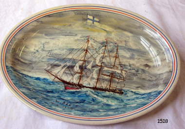 Flagstaff Hill Maritime Museum and Village
Plate
Bristile Hotel China Made in Australia. Plate oval shaped with a painting of a three masted ship, signed and dated. Norwegian flag painted above ship. flagstaff hill, warrnambool, shipwrecked-coast, flagstaff-hill, flagstaff-hill-maritime-museum, maritime-museum, shipwreck-coast, flagstaff-hill-maritime-village