Showing 10522 items matching " sections"
-
 Kew Historical Society Inc
Plan, Melbourne & Metropolitan Board of Works : Borough of Kew : Detail Plan No.1297, 1904
The Melbourne and Metropolitan Board of Works (MMBW) plans were produced from the 1890s to the 1950s. They were crucial to the design and development of Melbourne's sewerage and drainage system. The plans, at a scale of 40 feet to 1 inch (1:480), provide a detailed historical record of Melbourne streetscapes and environmental features. Each plan covers one or two street blocks (roughly six streets), showing details of buildings, including garden layouts and ownership boundaries, and features such as laneways, drains, bridges, parks, municipal boundaries and other prominent landmarks as they existed at the time each plan was produced. (Source: State Library of Victoria)This plan forms part of a large group of MMBW plans and maps that was donated to the Society by the Mr Poulter, City Engineer of the City of Kew in 1989. Within this collection, thirty-five hand-coloured plans, backed with linen, are of statewide significance as they include annotations that provide details of construction materials used in buildings in the first decade of the 20th century as well as additional information about land ownership and usage. The copies in the Public Record Office Victoria and the State Library of Victoria are monochrome versions which do not denote building materials so that the maps in this collection are invaluable and unique tools for researchers and heritage consultants. A number of the plans are not held in the collection of the State Library of Victoria so they have the additional attribute of rarity.Original survey plan, issued by the MMBW to a sewage contractor with responsibility for constructing sewers in the area identified on the plan within the Borough of Kew. The plan was at some stage hand-coloured, possibly by the contractor, but more likely by officers working in the Engineering Department of the Borough and later Town, then City of Kew. The hand-coloured sections of buildings on the plan were used to denote masonry or brick constructions (pink), weatherboard constructions (yellow), and public buildings (grey). This plan of Kew encompasses the area bounded by Barkers Road, High Street and Stevenson Street. Because of the angle created by High Street, a number of houses on the northern side of High Street are shown. The area is dominated by one of the great original landholdings in Kew, described here as the ‘Findon Paddock’. ‘Findon’, the house from which the name of the paddock was taken fronts Stevenson Street and was clearly a rambling structure. The best-known occupant of Findon was Henry ‘Money Miller’ who bought the house in 1871. Miller was a member of Victoria’s first parliament and assisted in the framing of its constitution. Findon was to be subdivided as early as 1912, when the Findon Subdivision was advertised to be sold by auction. In the plan of the subdivision, the original house is not shown, so, presumably it had previously been demolished. Fincham & Son moved the organ, built by Henry Willis, which was installed in the house, first to ‘Whernside’ in Toorak, and later to the Box Hill Methodist Church.melbourne and metropolitan board of works, detail plans, mmbw 1297, cartography, kew (vic.) — municipal collection -
 Kew Historical Society Inc
Plan, Melbourne & Metropolitan Board of Works : Borough of Kew : Detail Plan No.1568, 1905
The Melbourne and Metropolitan Board of Works (MMBW) plans were produced from the 1890s to the 1950s. They were crucial to the design and development of Melbourne's sewerage and drainage system. The plans, at a scale of 40 feet to 1 inch (1:480), provide a detailed historical record of Melbourne streetscapes and environmental features. Each plan covers one or two street blocks (roughly six streets), showing details of buildings, including garden layouts and ownership boundaries, and features such as laneways, drains, bridges, parks, municipal boundaries and other prominent landmarks as they existed at the time each plan was produced. (Source: State Library of Victoria)This plan forms part of a large group of MMBW plans and maps that was donated to the Society by the Mr Poulter, City Engineer of the City of Kew in 1989. Within this collection, thirty-five hand-coloured plans, backed with linen, are of statewide significance as they include annotations that provide details of construction materials used in buildings in the first decade of the 20th century as well as additional information about land ownership and usage. The copies in the Public Record Office Victoria and the State Library of Victoria are monochrome versions which do not denote building materials so that the maps in this collection are invaluable and unique tools for researchers and heritage consultants. A number of the plans are not held in the collection of the State Library of Victoria so they have the additional attribute of rarity.Original survey plan, issued by the MMBW to a contractor with responsibility for constructing sewers in the area identified on the plan within the Borough of Kew. The plan was at some stage hand-coloured, possibly by the contractor, but more likely by officers working in the Engineering Department of the Borough and later Town, then City of Kew. The hand-coloured sections of buildings on the plan were used to denote masonry or brick constructions (pink), weatherboard constructions (yellow), and public buildings (grey). Plan No.1568 covers the area bounded by Cotham Road, John Street, Sackville Street, and Edward Street. Alfred Street and Rowland Street are in shown in the middle of the plan. The two most notable buildings shown are ‘St Helliers’, the home of the Dumaresq family, and St Hilary’s Church and school. While the colours used to indicate St Hilary’s are grey as in other civic/public buildings, the first St Hilary’s Anglican Church was at this stage constructed in weatherboard. At the left of the plan, facing Sackville Street is a house named ‘Glencara’. The 1988 ‘Kew Conservation Study’ recorded that “The first documentary evidence of this house comes from Rate Books which record that in 1893 a Mrs Treadway was the owner of this building with an N.A.V. of £81? At that date the occupier of the house was Charles B. Kelly, a clerk, while by 1910 Kelly had become the owner of the property described in that year ‘as a six-roomed stone, brick and wood house with stables and outbuildings’”. Contrary to this description, the 1905 plan indicates that the house was entirely constructed of masonry.melbourne and metropolitan board of works, detail plans, mmbw 1568 -
 Kew Historical Society Inc
Plan, Melbourne & Metropolitan Board of Works : Borough of Kew : Detail Plan No.1571, 1904
The Melbourne and Metropolitan Board of Works (MMBW) plans were produced from the 1890s to the 1950s. They were crucial to the design and development of Melbourne's sewerage and drainage system. The plans, at a scale of 40 feet to 1 inch (1:480), provide a detailed historical record of Melbourne streetscapes and environmental features. Each plan covers one or two street blocks (roughly six streets), showing details of buildings, including garden layouts and ownership boundaries, and features such as laneways, drains, bridges, parks, municipal boundaries and other prominent landmarks as they existed at the time each plan was produced. (Source: State Library of Victoria)This plan forms part of a large group of MMBW plans and maps that was donated to the Society by the Mr Poulter, City Engineer of the City of Kew in 1989. Within this collection, thirty-five hand-coloured plans, backed with linen, are of statewide significance as they include annotations that provide details of construction materials used in buildings in the first decade of the 20th century as well as additional information about land ownership and usage. The copies in the Public Record Office Victoria and the State Library of Victoria are monochrome versions which do not denote building materials so that the maps in this collection are invaluable and unique tools for researchers and heritage consultants. A number of the plans are not held in the collection of the State Library of Victoria so they have the additional attribute of rarity.Digital copy of the original survey plan, issued by the MMBW to a contractor with responsibility for constructing sewers in the area identified on the plan within the Borough of Kew. The plan was at some stage hand-coloured, possibly by the contractor, but more likely by officers working in the Engineering Department of the Borough and later Town, then City of Kew. The hand-coloured sections of buildings on the plan were used to denote masonry or brick constructions (pink), weatherboard constructions (yellow), and public buildings (grey). This plan is part of a large and historically significant group of MMBW plans and maps that was donated to the Society by the Mr Poulter, City Engineer of the City of Kew in 1989. When the contracts were let for surveyors to identify and record the extant houses and landscapes within an area for the Board of Works, the contracts were let at separate times, hence the anomaly where two copies of Plan No.1571 exist in our collection. The first of these plans identifies the building materials used in houses bordering Fitzwilliam Street, Edgevale Road, May Street, Malin Street, Davis Street and Wellington Street. The cut off point for the survey was the south side of Wellington Street. By 1903 when the survey was undertaken many of the sites were already built on, particularly those facing Edgevale Road. The plan identifies the preponderance of weatherboard houses in the area. The other version of the plan identifies the buildings between Wellington Street and Cotham Road.melbourne and metropolitan board of works, detail plans, mmbw 1571, cartography -
 Kew Historical Society Inc
Plan, Melbourne & Metropolitan Board of Works : Borough of Kew : Detail Plan No.1573, 1905
The Melbourne and Metropolitan Board of Works (MMBW) plans were produced from the 1890s to the 1950s. They were crucial to the design and development of Melbourne's sewerage and drainage system. The plans, at a scale of 40 feet to 1 inch (1:480), provide a detailed historical record of Melbourne streetscapes and environmental features. Each plan covers one or two street blocks (roughly six streets), showing details of buildings, including garden layouts and ownership boundaries, and features such as laneways, drains, bridges, parks, municipal boundaries and other prominent landmarks as they existed at the time each plan was produced. (Source: State Library of Victoria)This plan forms part of a large group of MMBW plans and maps that was donated to the Society by the Mr Poulter, City Engineer of the City of Kew in 1989. Within this collection, thirty-five hand-coloured plans, backed with linen, are of statewide significance as they include annotations that provide details of construction materials used in buildings in the first decade of the 20th century as well as additional information about land ownership and usage. The copies in the Public Record Office Victoria and the State Library of Victoria are monochrome versions which do not denote building materials so that the maps in this collection are invaluable and unique tools for researchers and heritage consultants. A number of the plans are not held in the collection of the State Library of Victoria so they have the additional attribute of rarity.Original survey plan, issued by the MMBW to a contractor with responsibility for constructing sewers in the area identified on the plan within the Borough of Kew. The plan was at some stage hand-coloured, possibly by the contractor, but more likely by officers working in the Engineering Department of the Borough and later Town, then City of Kew. The hand-coloured sections of buildings on the plan were used to denote masonry or brick constructions (pink), weatherboard constructions (yellow), and public buildings (grey). This plan has detailed annotations written in red or blue ink, showing prices, which may be the annual valuations of the properties, and some owners’ names, a most unusual feature on contractor's maps. Some areas, such as the buildings of Methodist Ladies’ College (MLC), include the school’s tennis court and swimming pool, but are not coloured to show building materials – did the draftsman just run out of time, or ink, or enthusiasm, before his plan had to be submitted? MLC had been founded in 1882 as a ‘modern school of the first order’ with buildings that formed ‘a collegiate institution for girls unsurpassed in the colonies’. The goal of its founders was to provide a high-class Christian education for girls, comparable with that provided elsewhere for boys. Some shops are shown along Edgevale Road, though they are not designated as commercial premises. Larger houses are depicted, including ‘Fairlawn’ in Barkers Road, and ‘Clevedon’ and ‘Rosehill’ (now demolished) in Fitzwilliam Street.melbourne and metropolitan board of works, detail plans, mmbw 1573, maps - borough of kew, cartography -
 Royal District Nursing Service (now known as Bolton Clarke)
Photograph - Photograph, black and white, c.1980
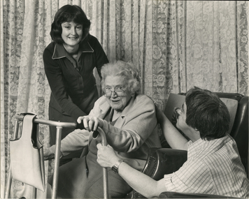
An RDNS Sister had previously visited Mrs. Crook in her home and assessed the nursing care she required. Following the Sister's instructions, the Home Health Aide in this photograph, Robin Brown, is assisting Mrs. Crook from her lounge chair onto her walking frame. Mrs. Crook's son, Robert is also assisting his mother. Home Health Aides were employed and trained by Royal District Nursing Service (RDNS) from 1980. They wore a RDNS royal blue uniform, which has a white trim and RDNS badge applied to the left hand side, and a dark blue cardigan. In 1980, a Home Health Aide ‘Pilot study’, funded by the Federal Government, the Brotherhood of St. Laurence and RDNS, with the program written and taught by RDNS Principal Nurse Educator. Pat (Paddy) Rowley, was evaluated as successful. Following this Pilot study, Home Health Aides were employed by RDNS, and after instruction in the RDNS Education department, joined RDNS Centres and worked under the supervision of the RDNS Trained nurses (Sisters). The Sister assessed each patient, then introduced and supervised the Health Aide in the patient procedure required. The Sister wrote out clear, concise procedural instructions on a work card which the Health Aide followed each visit. If the Health Aide noticed any change in the patient’s condition, this was reported immediately and the Sister visited. The Sister made routine visits to the patient for review at least monthly. On the left of this black and white photograph is Royal District Nursing Service, Home Health Aide, Robin Brown, who has dark shoulder length hair and is wearing a dark cardigan over her dark coloured uniform which has white piping at the edge. To her right is Mrs. Crook who is sitting froward in her lounge chair. A walking frame, which has a material bag hanging from the front bar, is in front of her. Robin Brown has her left hand on Mrs Crook's back and her right hand under her arm. Mrs. Crook has curly white hair; is wearing glasses which are resting partly down her nose, and is wearing a light coloured cardigan over her dark dress. Part of a necklace of pearls can be seen hanging over her dress. She is smiling and looking at the camera. She has her right hand on the upper part of the right wing of the walking frame and her left hand is on the top hand grip section on the left wing of the frame. To her right, her son, Robert, who is squatted down by the chair, has short dark hair and is wearing a checked shirt. He is holding the left wing of the walking frame with his left hand and his right arm is extended with his hand on his mother's back. Closed floral curtains are seen in the rear of the photograph.Photographer's stamprdns, royal district nursing service, home health aide, home health aide uniform, patient care, mrs crook, mr robert crook, home health aide robin brown -
 Royal District Nursing Service (now known as Bolton Clarke)
Photograph - Photograph, black and white, Barry Sutton, 22.06.1977
Royal District Nursing Service (RDNS) Sisters worked from this, their rented Collingwood Centre at 98 Charles Street, Collingwood, which opened in 1977. The Sisters left each morning taking any sterilized equipment needed with them to carry out their nursing visits in a specific area (district), They returned at the end of the day to write up their patients nursing histories, clean and reset any equipment used ready for re-sterilization, and contact other medical and community personal as necessary. From its inception as Melbourne District Nursing Society (MDNS), in 1885, their Trained nurses (Nurses) worked in specific areas, 'districts'. The first Nurse worked east and west, between Victoria Parade and Flinders Street and, north and south, between Spencer Street and Spring Street. When a second Nurse was employed they divided this area at Elizabeth Street so each Nurse could attend to patients in the same area giving continuity of care. Gradually over the years, Melbourne District Nursing Service (MDNS), later known as Royal District Nursing Service (RDNS) from 1966 when they received Royal patronage, opened Centres throughout the Melbourne Metropolitan area and outer suburbs with Heidelberg Centre opening in 1971. Their Trained nurses (Sisters) left from these Centres each morning to carry out their nursing visits in a specific area (district), taking any sterilized equipment needed with them. They returned at the end of the day to write up their patients nursing histories, clean and reset any equipment used ready for sterilization, and contact other medical and community personal as necessary. Through its expansion quality of care was not lost, the RDNS nursing staff gave best practice care in many fields of nursing and to people of many cultures with their patients ranging in age from babes, children, adults to the elderly. Some of the care provided was – Post-Natal care, Diabetic Care, Wound Care, Giving of injections and medications, Catheterizations on children and adults, Stoma care, Dementia care, Palliative Care, General care, Rehabilitation, Spinal care, Cystic Fibrosis care, Haemo-Oncology care, Home Enteral Feeding care, and IV therapy at home. Assisting with rehabilitation with an aim towards independence remained at the forefront of the Sister’s minds. All care included giving advice and support to the patient and their Carers. Black and white photograph showing the front facade of the Royal District Nursing Service (RDNS), Collingwood Centre. It is a Victorian style, single story, light coloured painted concrete faced building built around the 1870s. To its left is the front wooden door with a small central glass section in the upper center, and a wire door in front of this. To its right is an Electricity Department meter attached to the wall, and under this a large "98" and to its right, and a little lower is an attached rectangular white sign, with black capital letters, saying "Royal District Nursing Service" and below this in smaller letters "Collingwood". To the right sits a long sash window with dark frame. At either end of the building white concrete face extensions, with embellishments, support a corrugated iron straight veranda roof, with wrought iron embellishment attached to its outer edge. This sits above the window and door and runs along the building protecting the small porch. Above this, along the building, is deep decoration, including a row of concrete balusters and above and central is a concave shell shaped structure. A short dark metal spiked fence runs along the edge of the narrow garden bed. In the foreground the footpath and part of a road can be seen. A small bare tree can be seen on the left hand side of the building and a small bush on the right hand side.Photographer stamp. Quote No. DO 66royal district nursing service, rdns, rdns centre -
 Royal District Nursing Service (now known as Bolton Clarke)
Photograph - Photograph, black and white, Barry Sutton, c.1970
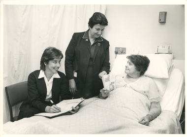
This photograph shows Royal District Nursing Service (RDNS) Sister (Sr.) Moira Coates doing Liaison work at St. Vincent's Hospital in Melbourne. Miss C. Healy is St. Vincent's Home Care Supervisor and she and Sr. Coates are discussing plans with Miss E. Monks for the future care she requires following her discharge from hospital. Sr. Coates is wearing the RDNS uniform of a royal blue dress with white piping around the peaks of the collar. An RDNS logo is on its upper left. She is wearing a darker blue jacket.Liaison had occurred between Doctors and the the Trained nurses (Nurses) of the Melbourne District Nursing Society (MDNS), from its inception in 1885. This increased when Midwifery was introduced in August 1893 with close liaising with the Women’s Hospital. As District nursing grew it was recognized that closer liaising between many Public Hospitals would be beneficial, for not only the MDNS, later called Royal District Nursing Service (RDNS), Trained nurses (Sisters), but also for the patients and the hospitals. In August 1964 a Liaison Officer commenced at the Alfred Hospital. This soon increased to Liaison Officers working full time at several Public Hospitals. They facilitated the smooth transition from hospital to home for many patients who required ongoing nursing care. Liaison Sisters regularly attended discharge planning meetings, interviewed prospective patients, co-ordinated discharge and booked the first visit by the visiting RDNS Sister. At the time of a patient’s discharge, the Liaison Sister forwarded information on their diagnosis and instructions regarding the care required at home to the appropriate RDNS Centre, and in turn the attending District Sister wrote a report of progress and any queries to the Hospital Doctor, via the Liaison Sister, at the time the patient was attending outpatients. Any new instructions were then sent back to the District Sister. Liaising also occurred between District Sisters and Doctors when patients were referred by General Practitioners and did not attend a hospital.In the left foreground of this black and white photograph is Miss C. Healy who has collar length dark hair and is wearing a hospital uniform dark cardigan over a white blouse and dark skirt. She is sitting on a kitchen style chair and has an open folder; a pen in her right hand is poised over a white sheet of paper. She is smiling and looking to her left at Miss E. Monks who is resting in a bed in front of her. Standing to her right, and at the head of the bed, is RDNS Sister Moira Coates who has short dark hair. and is wearing a dark jacket over a dark colour dress with white piping on the collar peaks. Her identity card is clipped on the right hand pocket. She is smiling at Miss Monks and has her left hand on an RDNS leaflet which Miss Monks is holding. To her right is Miss Monk who has short dark hair and wearing a light coloured nightdress. She sitting up supported against pillows on a hospital bed which has the top section raised. She is looking at the RDNS folded leaflet; two photographs and writing can be seen on the front cover. White bedclothes cover most of Miss Monks body. Drawn curtains are seen in the left rear of the photograph and some switches and a name card are seen behind the bed. Barry Sutton. LJ93 and namesrdns, royal district nursing service, rdns liaison, rdns uniform, sister moira coates, miss c. healy, miss e. monks -
 Villa Alba Museum
Decorative object - Gilt metal fringe for furnishings - detached
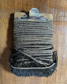
It is not clear that this fringe was ever attached to the curtain suite; it may have come from an associated part of the original ensemble (eg pelmet) or from associated furniture. However, it is certainly connected to the fringe on the tieback tassels, whose tassels are finished with the same product. The detached gilt metal fringe has aesthetic significance as specimen of an opulent furnishing decoration in very lavish contexts, such as gold rush Victoria. Part of it still preserves the original bright gold metal, ie is untarnished; this is probably quite rare in Australian collections.Board wrapped w c.17m of heavy gilt metal fringe (known as bullion fringe) in several pieces, evidently detached from curtains, and/or furniture items. (No sign of it having been attached to the curtains). The fringe is composed of metallic thread very tightly wound over a cotton/linen thread, attached to a narrow header braid with an ornamental design worked in metallic gimp cord. The colour was originally gold, now tarnished on all parts exposed to air, but sections of the fringe under the top layers retain the luxurious gold finish. Westman (2019: 242) explains that 'gold thread' was made of gold fired onto silver bars from which thin, flat or round wires were cut to wrap around a core linen thread for use in trimmings. Shen notes that the very thin layer of gold often wears away, exposing the silver which tarnishes. Bullion fringe: fringe made of bullion, in the sense of precious metal, used for prestigious royal, ecclesiastical and military garments and furnishings. Westman (2019: 193, 240) says that by the 19thC, the name was also used for twisted thread long fringe made of wool, silk, cotton or a mix, as it is today. In this form, 'bullion fringe' became a lavish edge-trim in the early-mid-19thC wherever its vertical look could add richness to drapery. interior decoration - history -
 Wodonga & District Historical Society Inc
Functional object - Edison Phonograph Records
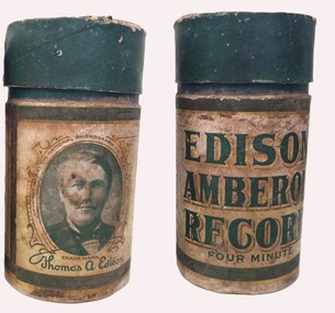
Edison cylinders were the earliest commercial medium for recording and reproducing sound. These hollow cylindrical objects have an audio recording engraved on the outside surface which can be reproduced when they are played on a mechanical cylinder phonograph. Beginning in 1889, pre-recorded wax cylinders were marketed. These have professionally made recordings of songs, instrumental music or humorous monologues in their grooves. The earliest cylinders were made from soft wax and later hard wax was utilised. Further developments by several companies, led to the introduction of celluloid cylinders. In late 1908, Thomas Edison had introduced wax cylinders that played for about four minutes (instead of the usual two) under the Amberol brand. The Amberols were manufactured with flat rim-ends, to prevent confusion with the earlier bevel-edged two-minute version. In 1912, the Edison company eventually acquired patents to the celluloid technology, and almost immediately started production under new brand as Edison Blue Amberol Records. Cylinder records continued to compete with the growing disc record market into the 1910s. In 1912, Columbia Records, which had been selling both discs and cylinders, dropped the cylinder format, while Edison introduced his Diamond Disc format, played with a diamond stylus. From 1915, new Edison cylinders were re-recordings from Edison discs. Although his cylinders continued to be sold in steadily dwindling quantities, Edison continued to support the owners of cylinder phonographs by making new titles available in that format until the company ceased manufacturing all records and phonographs in November 1929.This item is significant because it is representative of home entertainment in the late 19th and early 20th century.Two phonograph cylinders in cardboard boxes. The first cylinder is an earlier 2 minute Edison Gold Moulded Record with Issue Number 9184. It features a recording of "Paddle your own Canoe" by Arthur F. Collins and Byron G. Harlan and was released in January 1906. The second cylinder is a 4 minute Edison Amberol Record (NO. 647) featuring the Levy-Athan Polka performed by Charles Daab on xylophone and accompanied by an orchestra. It was released in February 1911. The case is cylindrical in shape and made of cardboard. It is coloured green, white, and black on the outside, while the base is not coloured. The tube is open at the top, and sealed at the base. Inside the tube is a white fabric lining. The top section of the outside of the tube is dark green. Below this is an outer sleeve. The outer sleeve has a half white, half green background with a black stripe, with gold outline, running horizontally around the top and bottom. The words "Thomas A. Edison" are printed in green cursive along the band. In the centre of the sleeve is the text " EDISON AMBEROL RECORD FOUR MINUTE" in green ink. To the left of that text is a green-toned image of Thomas Edison in an ornate, gold border. This is surrounded by the words “Copyright 1900 by the National Phonograph Co. Orange N.J. U.S.A". To the right of the text is a rectangular text box with a black border, which contains patent information in green text. edison phonograph, home entertainment, music early 20th century -
 University of Melbourne, Burnley Campus Archives
Photograph - Black and white photographs, A.W. Jessep, Grafting and Cutting Display, Unknown
Black and white photographs of various sizes pasted on cardboard for display purposes. Some annotated. Labelled: (1) Rose with 4 pieces cut off it. (2)"Citrus rootstock in nursery ready for budding." (3) "Feb. Left. Healthy budstick of current season's growth. Right. Prepared budstick, foliage and undeveloped buds removed, short section of leaf-stick reatined." (4) Same as (3). (5)"Harvest scions while dormant and store in moist, well-drained soil." (6) "Whip-tongue graft after one season of growth." (7) "Graft after one season of growth." (8) "Mastic applied to keep air and moisture from the cut surfaces." (9) "Graft tied to prevent movement." (10) "Young camellia-struck cutting." (11) Cutting beside pot. (12) "Feb. Same pot camellia struck." (13) Clump of dug-up perennials. (14) Divided piece. (15) Trimmed. (16) "April. Seedling Polyanthus." (17) Cuttings. (18) Clump of rooted cuttings. (19) Trimming rooted cutting. (20) Clump of Begonia. (21) Dividing Begonia. (22) Begonia leaf cut into pieces. (23) Rooted cuttings from leaf. (24) Putting leaf pieces in pot. (25) Pot of rooted cuttings. (26) Lupin seedlings emerging. (27) Lupin seedlings. (28) Clump of roots? From A. W. Jessep.roses, nursery, budstick, grafting, growth, camellia, polyanthus, cutting, trimming, begonia, dividing, a. w. jessep, citrus rootstock, scions, whip-tongue graft, perennials, lupin seedlings, teaching -
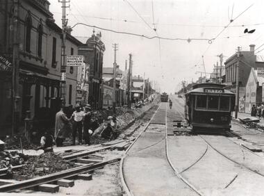 Melbourne Tram Museum
Photograph - Black & White Photograph/s, Melbourne & Metropolitan Tramways Board (MMTB), 1926
Black and white photograph of MMTB No. 58 in Wellington St. St Kilda, about to enter St Kilda Junction and continue to St Kilda beach via Fitzroy St St Kilda, late 1925 or early 1926 - Wellington St electric line opened 27/12/1925. Note the sign on the left hand pole about travel to Malvern and St Kilda Beach, the workmen and that another tram has left heading outwards. On the right hand side is part of a sign advising people to catch cars to the Esplanade. Photo from the Collection of the Department of Infrastructure now with the Public Records Office - image number H102. Note: this photo is now out of copyright and was not an original VR photograph, but one copied from another source and collected as their Heritage series. See Image 3673i2 for a digital image of the card photograph at the PRO on 7/1/2019 that this photograph comes from. Further notes from Rod Atkins: Note the Electrical box at base of the pole on left hand side of the photo. No section insulators yet as power would have been stretched from Dandenong Road / Chapel Street right through to Fitzroy Street to run the first services. Great shot of the "H" car. Malvern bound is a another Californian combo car, but with original destination boxes and PPTT style "No" on the left side of the apron but cant make out the number.Has Department of Infrastructure copy right stamp on rear and number "H 102" in ink on rear and "2-3"trams, tramways, mmtb, st kilda junction, wellington st, trackwork, st kilda beach, tram 58 -
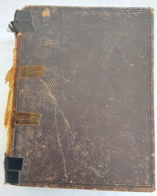 Mont De Lancey
Book, Rev. John Brown, Brown's Self-Interpreting Family Bible, 1862
A late Victorian family Bible— the beloved King James text, augmented by the late Revd John Brown of Haddington’s Comprehensive Bible study aids which was well bound. First published in 1611, the King James Version of the Bible has exercised an incalculable impact on piety, language and literature throughout the English-speaking world. "Other translations may engage the mind, but the King James Version is the Bible of the heart" (Campbell, 275). It is probably the text most commonly found in decorative family Bibles such as this one, which has several black and white plates. The Rev. John Brown of Haddington was "a tirelessly faithful pastor"—"For eight months of the year he delivered a lecture, two sermons, and an exercise each Sunday"—and also a prolific author. He is best remembered for his Self-Interpreting Bible, first published 1778, which became "as familiar in Presbyterian households as John Bunyan's Pilgrim's Progress and Thomas Boston's Human Nature in its Fourfold State" (DNB). Without Apocrypha. There is a Separate New Testament title page dividing the bible. Opposite page 832 is The Family Register fully handwritten in black ink Old English script commencing with Peter Sebire born 14th June 1835 Sen Died 20th September 1902 (67 years). Many other entries are listed.Brown's Self-Interpreting Family Bible. London: Blackie and Son 1862. A thick dark brown volume with a tiny embossed diamond shaped self-pattern on both covers. All edges of pages are gilt, The title, Holy Bible is printed in gold lettering at the top of the spine and it has five raised bands across it. The black and white decorative title page has Brown's Self-Interpreting Family Bible with many Additional notes, References and Readings, also Index of subjects printed at the top. Underneath in a semi-circle shape is a black ad white illustration of Ruth and Naomi, with publisher details below. The following Title Page has full details and explanations of the contents. There is a Publisher's Preface and Attestations to this Edition. Following this is a Memoir of The Rev. John Brown, closing with his final words upon his death on 19th June 1787. He was buried at Haddington Churchyard 24th June A.D. 1787, aged 65 years. Following this is an Introduction to the Right Understanding of the Oracles of God. There are many black and white plates included throughout the Bible. Pp. 1157 (Bible) At the back are many additional inclusions such as: Alphabetical Index, A Collection of Similies contained in the Scriptures, Complete Index, and Concise Dictionary, The Psalms of David in Metre, Translations and Paraphrases and more. There are missing pages of the Hymns. In all a most complex Bible for the family. Included are four loose pages with details of some of the Sebire Family Tree as noted in the Inscriptions section below. non-fictionA late Victorian family Bible— the beloved King James text, augmented by the late Revd John Brown of Haddington’s Comprehensive Bible study aids which was well bound. First published in 1611, the King James Version of the Bible has exercised an incalculable impact on piety, language and literature throughout the English-speaking world. "Other translations may engage the mind, but the King James Version is the Bible of the heart" (Campbell, 275). It is probably the text most commonly found in decorative family Bibles such as this one, which has several black and white plates. The Rev. John Brown of Haddington was "a tirelessly faithful pastor"—"For eight months of the year he delivered a lecture, two sermons, and an exercise each Sunday"—and also a prolific author. He is best remembered for his Self-Interpreting Bible, first published 1778, which became "as familiar in Presbyterian households as John Bunyan's Pilgrim's Progress and Thomas Boston's Human Nature in its Fourfold State" (DNB). Without Apocrypha. There is a Separate New Testament title page dividing the bible. Opposite page 832 is The Family Register fully handwritten in black ink Old English script commencing with Peter Sebire born 14th June 1835 Sen Died 20th September 1902 (67 years). Many other entries are listed. bibles, religious books, religion, genealogical charts, genealogy, genealogical documents, family trees -
 University of Melbourne, Burnley Campus Archives
Document - Personal files, Andrew Smith's Files, 1981-2022
cactus, cacti, clematis, orchard redevelopment, r. hall, geoff olive, pruning garden, field station, vcah, university of melbourne, burnley, jill kellow, field station redevelopment, field nursery, student gardens, turfgrass, grassy woodland, chris findlay, phil tulk, grasslands, herbaceous border, car park, native garden, restoration native garden, john rayner, hilda kirkhope rockery, herb garden, rainforest garden redevelopment, plant lists, shady walk, salvia, trees, tai-haku cherry, tree management, tree lists, david aldous, grey border -
 Eltham District Historical Society Inc
Document - Property Binder, 616 Main Road, Eltham; Plum Cottage
Plum Cottage is covered by Heritage Overelay HO256 in the Nillumbuk Planning Scheme This two-lot land holding was created as a subdivision and sold to Charles Stuart McNeil by May 1955. Sometime in the period 1955-1960, the builder-designer, John Harcourt had created a pise house on the site, straddling the two subdivision lots. The designer, John M. Harcourt was a pioneer builder in pise-de-terre and mudbrick in the Eltham Shire, Eltham being synonymous with alternative lifestyles and building practises until the onset of suburbia in the late 20th and early 21st centuries. This hipped-roof house is set high above Main Road on a V-shape plan characteristic of the Arts & Crafts style, with rammed earth or pise walls, timber joinery and a cement tiled roof. The V shape plan was used by important English and Eltham Arts & Crafts designers. The use of natural materials such as stone and timber construction is an essential part of the Arts & Crafts style and Harcourt’s work. So too is the application of the style on both the exterior and interior of the house as a holistic concept. The house adjoins the Lim Joon adobe house built and designed by Alistair Knox in the same era (HO119), thus forming a distinctive pair, both using an uncommon plan form. This house was identified in the Shire of Shire of Eltham Heritage 1992 as contributory to the Eltham Gateway Conservation Area, then proposed as an urban conservation area (now Heritage Overlay Area). Land Ownership Emily Jane Smith of 12 Woodside Street Fitzroy owned Crown Allotments 1 & 2 Sections 14, 27 by August 1918, selling to William Henry Smith of 12 Woodside Street, Nth Fitzroy May 1921. (John) James Isherwood of Main Road, Eltham owned the property by 1928 (the year of his death) with the beneficiary of his estate and next owner of this site being his widow, Minnie Maria Isherwood of Cemetery Road, Eltham. His holding in Main Road included parts of what was described in rate records as allotments1 & 2 Section E6. In the late 1930s, early 1940s her son Alfred John Isherwood was also rated for the land around this site, with the rated nett annual value varying between £2 and £5. Alfred Isherwood also lived at Main Road, Eltham with his wife Ellen: her early death at the age of 24 was reported in the Argus of 1923. Part of the Isherwood land was divided off and sold to Charles Stuart McNeil by May1955. Sometime in the period 1955-1960, the builder-designer, John Harcourt had created a pise house on the site, straddling the two subdivision lots. The house is visible on an aerial photograph from 1960s. Reputedly the house was called Plum Cottage and erected for Harcourt’s mother-in-law. A garage was added in 1959. Charles McNeil died in1971 aged 87: he was the son of Don McNeil and Margaret Arkell. Available rate records from the construction era start in the of the 1970s (1972-3) and list Mr H.C. & M/S A.V. Charity at 616 Main Road Eltham of this property with a nett annual value of $740. More recent valuer's data describes the property as lots 1 & 2 LP25668, located in the Central Riding of Eltham Shire, owned by Ann Valerie Charity and later, in 1990, by the Chincarini family. Building Description This hipped roof 11 .5 square house is set high above Main Road on a characteristic-shape plan and has rammed earth or pise walls, timber joinery and a cement tiled roof. The V-shape plan was used by Important designers such as C.F.A. Voysey (UK) who interpreted medieval domestic architecture as part of the Arts & Crafts style of the late 19th and early 20th centuries. The pise walls are covered with a textured render while the cement roofing tiles are also seen in the Harcourt Hill examples. Reputedly the ceiling joists are of a deep section and span long lengths with no need for hanging beams in the roof space. The ceilings are low and panelled in main rooms with apparently Caneite soft board infill panels between the exposed ceiling beams. These are painted white but may have been stained at one time. The focus of the house is the large living area with its vast random stone fireplace. Significance Plum Cottage is significant to the locality of Eltham because: Historically: • Plum Cottage is closely associated with the important historical theme of earth construction evident in Eltham and elsewhere in the Shire since theear1y Arts & Crafts inspired creations at Penleigh Boyd's The Robins (1912, HO101) and those at Montsalvat (1934-, HO82) but more prominent from the Second War period when earth building in Eltham was promoted in national periodicals as an alternative building method that avoided the building materials shortages of that era; • The choice of the earth building technique also expresses the theme of refuge or alternative living, synonymous with Eltham in the early to mid 20th century; • as a good example of domestic architecture from John Harcourt who was the first major post Second War figure in an important phase of Eltham’s earth building development, using his characteristic Old English or Arts& Crafts style that relies in this case on the pise wall construction, pitched roof forms, exposed ceiling joists, half timbering, random stonework, and panelled internal wall finishes. Architecturally: • Plum Cottage's pise wall construction is uncommon among the early earth-walled structures in the Shire, that are mainly of adobe or mud brick, and as a building material is uncommon among the Shire’s suburban dwellings generally which are clad typically with either fired clay bricks or timber boarding. Aesthetically: • Plum Cottage is a good and well preserved example of a modern Old English or Arts & Crafts style earth-walled building in the Shire • For the proximity of the significant Lim Joon adobe house designed by Alistair Knox adjoining to the north, providing a distinctive earth wall house pair, with uncommon plan forms. Reference Heritage Assessment of Plum Cottage, 616 Main Road, Eltham; Graeme Butler & Associates 2010main road, eltham, property, houses, (john) james isherwood, alfred john isherwood, ann valerie charity, arts and crafts style, charles stuart mcneil, chincarini family, eltham gateway zone, emily jane smith, h.c. charity, heritage assessment, john harcourt, john m. harcourt, lim joon house, main road eltham, minnie maria isherwood, pise construction, plum cottage -
 Eltham District Historical Society Inc
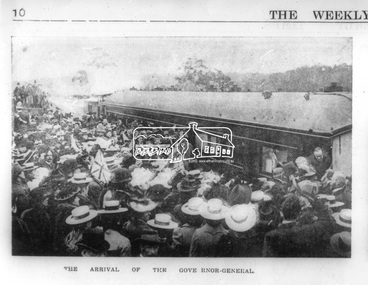
Photograph, Opening of the Railway Line; The arrival of the Governor-General, 6 June, 1902, 1902
Published: The opening of the railway line by His Excellency The Governor General, The Weekly Times, June 14, 1902, p10. Governor General was John Hope, Earl of Hopetoun THE HEIDELBERG TO ELTHAM RAILWAY. OPENING CEREMONY. The opening of the railway line from Heidelberg to Eltham took place on the 6th inst. The special train, containing a large number of members of Parliament, including Mr Trenwith, the Minister for Railways, left Prince's Bridge at half-past eleven, and arrived at Eltham at twenty minutes past twelve. The party was accompanied by Mr Fitzpatrick, Acting Commissioner for Railways; Mr Lockhead, the Traffic Manager; and Mr Norman, Engineer for Existing Lines. On arrival, the visitors were entertained at a banquet in the marquee, of which a photograph is given, erected close to the railway station. Mr E. H. Cameron, M.L.A., the member for the district, occupied the chair, and, seated on his right, was Mr Mason, the Speaker of the Legislative Assembly, and on his left the Minister of Rail-ways. After the banquet His Excellency the Governor-General arrived, and was received and welcomed by Mr Cameron, the local State school children singing the National Anthem. The Governor-General, in declaring the line open, said that he felt highly honored at being asked to perform the opening ceremony, and he trusted that the railway would be a source of great convenience to the inhabitants of the district. He was sorry to say that this would be the last opportunity he would have of seeing them. It cost him a great deal to leave them. (Hear, hear.) He had a great many friends amongst all sections of the community, and he could hardly bear to trust himself to speak about leaving them. (Hear, hear.) He was sorry Lady Hopetoun was on the high seas, and unable to accompany him that day. Mr Cameron thanked his Excellency for performing the opening ceremony, and hoped the trip home would have the effect of restoring His Excellency to good health again. In replying. Lord Hopetoun thanked them sincerely for the cordial vote of thanks. He hoped Providence would shower her blessings over them, and that they would have a series of good seasons. He would always keep a warm corner in his heart for the people of Victoria. (Loud cheers.) THE COUNTRY. In our illustrations, views are given of a couple of sections of the new line, and glimpses of the surrounding country are shown. The line is eight miles in length, and cost £51,000 in construction. Eltham, which is the terminus, possesses many of the features that go to make a favorite holiday resort. It is a quiet picturesque little hamlet, snugly ensconced on the slope of one of many sombre-tinted hills by which it is sur-rounded. Even when viewed under ad-verse conditions one could not fail to be-impressed with the natural, rugged beauty of the place. It is situated about sixteen miles from Melbourne, and the line takes a circuitous course through a continuation of pretty undulating country. At intervals on the slopes of the surrounding green-mantled hills, patches of brown, freshly tilled soil indicate that for all its serene reposeful-ness Eltham possesses its phases of industrial life as well. Looking down into this valley from the main road which skirts the slope of a hill, distant something less than a quarter of a mile from the railway station is one of the prettiest pieces of scenery in the district. Verdure-clad hills ascend on all sides, whilst beneath stretches a broad expanse of carpet-like green sward, dotted here and there with picturesque homesteads, each with its patches of tilled soil. In the township itself the dwelling-houses are comparatively few, the larger portion of the inhabitants residing in the scattered homesteads. Eltham is as yet only in its youth, but energetic and un-tiring public men can effect wonders in a community's prosperity, and Eltham, whatever other real or imaginary advantages it may lay claim to, certainly possesses this one. The railway is the result of their endeavor. 1902 'THE HEIDELBERG TO ELTHAM RAILWAY.', Weekly Times (Melbourne, Vic. : 1869 - 1954), 14 June, p. 14. , viewed 26 Sep 2018, http://nla.gov.au/nla.news-article221230719This photo forms part of a collection of photographs gathered by the Shire of Eltham for their centenary project book,"Pioneers and Painters: 100 years of the Shire of Eltham" by Alan Marshall (1971). The collection of over 500 images is held in partnership between Eltham District Historical Society and Yarra Plenty Regional Library (Eltham Library) and is now formally known as the 'The Shire of Eltham Pioneers Photograph Collection.' It is significant in being the first community sourced collection representing the places and people of the Shire's first one hundred years.Digital image Negative black and white film 120 6x9 format 2 stripsAgfa APX 100sepp, shire of eltham pioneers photograph collection, eltham, heidelberg-eltham railway extension, earl of hopetoun, john hope, opening day, railway line construction -
 Eltham District Historical Society Inc
Photograph - Digital Photograph, Alan King, Stonygrad, 34 Hamilton Road, North Warrandyte, 30 January 2008
Vassilieff dynamited rock from his own property to build his house. Stonygrad is reminiscent of a grotto and in parts, of a sculpture. Covered under Heritage Overlay, Nillumbik Planning Scheme. Published: Nillumbik Now and Then / Marguerite Marshall 2008; photographs Alan King with Marguerite Marshall.; p135 Stonygrad, the home built by Expressionist painter and sculptor Danila Vassilieff, is reminiscent of a grotto and in parts, of a sculpture. Vassilieff, who amongst others influenced painter Sydney Nolan and Albert Tucker, was a member of the artists group the Angry Penguins. He was also a highly regarded art teacher at the nearby Koornong Experimental School and taught at Eltham High School. Art critic Robert Hughes described Vassilieff’s painting as ‘lyrical without social commentary’, and said Vassilieff was ‘the most oddly neglected artist in recent Australian History’. Vassilieff, who was born in 1897 in Russia, had an unusually adventurous life before he settled in Warrandyte. The 12th of 18 children, he lived on a farm in the Don Basin. Vassilieff trained with the Imperial Military Academy at St Petersburg and fought in World War One as an officer in the White Russian Army against the communists. In 1920 he was captured, then escaped from prison, stole a horse and rode bareback 150 miles to the Black Sea, helped at first by Tartar freebooters. He then travelled to India, Shanghai and arrived in Queensland as a refugee in 1923 where he began painting. He and his wife Anisia bought a sugar farm near Ingram, and later he constructed railway lines at Mataranka, in the Northern Territory.4 In 1929 Vassilieff went to Brazil for formal art training from former fellow-officer Dmitri Ismailovich, but he soon left to travel up the Amazon River. He then worked as a sidewalk artist in the West Indies and travelled for two years in England, France and Spain. In 1937 he arrived in Melbourne where he lived until his death in 1958. His first major Australian series was the Carlton streetscapes and from 1951 he sculpted in local hard limestone. Vassilieff rejected all dogma and regarded religious subjects as suitable only for decorative arts. In 1944 he helped defeat a communist attempt to take over the Contemporary Art Society. For a short time, from around 1955, Vassilieff taught at various Victorian schools. The Angry Penguins painted mainly between 1937 and 1947, and included Arthur Boyd, Albert Tucker, Sidney Nolan and Joy Hester. The group formed as they felt isolated from European thought and art (including Surrealism) from which their work was derived. They were also angry at what they considered to be the complacency and insularity of their society. They maintained Australians at first were scarcely aware of the threats of the Wall Street Crash and Hitler and were little interested in the Spanish Civil War. The Angry Penguins also objected to the White Australia Policy. Hughes said although most of the Melbourne Expressionists in the 1940s were unskilled and their work crude in style, they helped jolt Australian painting from its pastoral complacency. Their style influenced nearly every painting produced by significant figurative artists in Melbourne in the 1950s such as Charles Blackman. From 1939 Vassilieff built Stonygrad, mainly with local stone. The house stands at the end of a private road surrounded by trees with the quiet occasionally broken by the sounds of bellbirds. To build his house Vassilieff dynamited rock and cut trees from his own property. The original section of the three-level house is of irregular-shaped pieces of solid stone, exposed inside like the exterior. Vassilieff later built sections with timber and brick. Inside is rustic and cave-like, and several rooms are linked by arched openings with no doors. One undulating wall was carved out of rock from which two sculptured heads protrude. Several ceilings are of rough-hewn logs and the built-in table and bookcase are rough, as is a timber ladder leading to a bedroom. Not for the elderly or unsteady! Yet the general impression in the muted light is beautiful, with artistic originality.This collection of almost 130 photos about places and people within the Shire of Nillumbik, an urban and rural municipality in Melbourne's north, contributes to an understanding of the history of the Shire. Published in 2008 immediately prior to the Black Saturday bushfires of February 7, 2009, it documents sites that were impacted, and in some cases destroyed by the fires. It includes photographs taken especially for the publication, creating a unique time capsule representing the Shire in the early 21st century. It remains the most recent comprehenesive publication devoted to the Shire's history connecting local residents to the past. nillumbik now and then (marshall-king) collection, danila vassilieff, hamilton road, north warrandyte, stonygrad -
 Eltham District Historical Society Inc
Photograph - Digital Photograph, Alan King, Sweeney's Cottage, Sweeneys Lane, Eltham, 30 January 2008
Part of the original cottage named Culla Hill built by Thomas Sweeney (a former convict) remains as a small section of today’s house. Covered under Heritage Overlay, Nillumbik Planning Scheme National Estate National Trust of Australia (Victoria) Local Sifgnificance Published: Nillumbik Now and Then / Marguerite Marshall 2008; photographs Alan King with Marguerite Marshall.; p19 Thomas Sweeney, a former convict who became a respected citizen, once lived on a property at what is now the corner of Sweeneys Lane and Culla Hill, Eltham. As Sweeney was one of the district’s first settlers, the property is registered by the National Trust. Thomas Sweeney was born in 1802, son of impoverished tenant farmers in Tipperary County, Ireland. He became a ploughman, then at 21 he was sentenced to hang for setting on fire the house of Patrick Guyder at Gullshill. It is said the arson was due to a dispute over undelivered guns to a social justice guerilla group, the White Boys, of which Sweeney was a member. But the sentence was commuted to life transportation to Australia in 1823.1 Apparently in Sydney he became a servant to James Chandler at Botany. Soon James Chandler leased his farm and became a catechist on the Hawkesbury River, so Sweeney was reassigned to a former convict, John Brown, at Liverpool. Later Sweeney was assigned to George Brown of Lake Illawarra. In 1831, Sweeney was granted a ticket-of-leave and bought a boat to carry goods between Illawarra district and Sydney Town. He married his first wife who had come to Australia as a free woman. However she drowned after bearing him a daughter. In 1838, one month after he had received a conditional pardon, Sweeney married a blacksmith’s daughter, Margaret Meehan, newly arrived from Ireland. They then moved to Port Phillip and squatted on the south side of the Yarra River, about seven miles (11km) from Melbourne. Around 1842, Sweeney bought 110 acres (44.5ha) in the parish of Nillumbik for £110. He built a slab hut 12 x 10 feet (3.6m x 3m) and then his homestead, Culla Hill, a typical Tipperary style cottage, now known as Sweeney’s Cottage. It was here that many generations of Sweeneys lived for almost 100 years. Culla Hill became a social centre for the district and the Catholic community used it as a church. Sweeney was apparently on good terms with a tribe of Aborigines living on the river nearby, who helped him build his house.2 Sweeney proved himself a civic-minded leader. In 1844, he led a call for a bridge over the Plenty River. He was on the first school board and supplied the first grain for Eltham’s mill. Sweeney profited during the gold rush, not by gold digging, but by providing supplies for nearby fields and others as far away as Beechworth.3 Thomas Sweeney died in 1867 and was buried at the Eltham Cemetery, leaving two sons, five daughters, and 300 acres (121.4ha), as well as Culla Hill. Culla Hill – by then reduced to 75 acres (30ha) – was sold out of the family in 1939, then renamed Sweeneys. The present Sweeneys Lane, running diagonally through the original holding, was the track to the house. Part of the original cottage remains as a small section of today’s house. The dining-family room fronted by a veranda is original, and although there have been some changes, the cedar door and most of the small 12-paned wooden-framed windows are original. The walls are made of the original hand-made brick. After buying the property in 1952 Mr and Mrs Burston demolished a dilapidated slab hut, a three-roomed detached kitchen and cellar, as materials needed to restore them were very difficult to obtain so soon after the war.4 However the barn remains almost in its original condition. It is believed to have been built from stone quarried on the property. Now roofed with iron sheets it was probably originally thatched. The sandstone barn has a peaked roof supported by the original saplings and a doorway large enough to accommodate a fully loaded wagon.This collection of almost 130 photos about places and people within the Shire of Nillumbik, an urban and rural municipality in Melbourne's north, contributes to an understanding of the history of the Shire. Published in 2008 immediately prior to the Black Saturday bushfires of February 7, 2009, it documents sites that were impacted, and in some cases destroyed by the fires. It includes photographs taken especially for the publication, creating a unique time capsule representing the Shire in the early 21st century. It remains the most recent comprehenesive publication devoted to the Shire's history connecting local residents to the past. nillumbik now and then (marshall-king) collection, culla hill, eltham, sweeney's cottage, sweeneys lane, thomas sweeney -
 Flagstaff Hill Maritime Museum and Village
Photograph - Historical, building, Late 19th to early 20th century
The black and white photograph depicts the Lady Bay Lighthouse Complex at Flagstaff Hill, Warrnambool. It was opened on this site in 1871. From left to right, the Chartroom (previously named the Store), Upper Lighthouse, Flagstaff, Lighthouse Keeper's Quarters. The bluestone buildings are facing North on Merri Street. The Harbour Pilot's Lodgings were on the east of the Complex. There are two unknown male figures standing in front of the light-coloured picket fence that encompasses the Complex. The photograph is mounted on card. WARRNAMBOOL'S LADY BAY LIGHTHOUSES In the 1800s ships sailing from England to Australia began to use Bass Strait as a faster route to Melbourne. Small navigation errors led to many tragic shipwrecks. From 1848 lighthouses were operating along Victoria’s southern coast as a guide for sailors. Coastal towns such as Warrnambool grew and the exchange of trade and passengers was of great benefit. However, the uncertain weather changes, relatively shallow waters and treacherous, hidden rocky reefs were not really suitable for a Harbour and in the 1840s and 1850s, there were many shipwrecks in the area, with some even stranded in its Lady Bay harbour. A jetty was built in 1850 and a flagstaff to guide seafarers was placed up high on what became known now as Flagstaff Hill. In November 1857 the Victorian Government recommended that Warrnambool Harbour had beacons and two lighthouses to guide vessels into and out of the Harbour safely. The white light of the Middle Island lighthouse was to be used for the first time on September 1, 1859. The red light of the Beach Lighthouse, a wooden obelisk structure, was first operated on March 25, 1860, but in 1868 this light was ‘discontinued’ due to it being too low. Melbourne’s Department of Public Works decided to relocate the Middle Island Lighthouse Complex - Lighthouse, Keeper’s Quarters, Privy, Store Room and even water tanks - to Flagstaff Hill. The lower obelisk was shortened, and a protruding gallery, railing, and external ladder were added, and the light from the Beach Lighthouse. A green guiding light was erected on the end of the jetty. The transfer of the Complex began in March 1871. Each shaped stone of the lighthouse was carefully numbered, removed then reassembled on Flagstaff Hill. In 1872 the well was sunk behind the Lighthouse Keeper’s Cottage. The Keepers and families had left Middle Island in April and moved to Flagstaff Hill in October 1871. Vessels entering Lady Bay align the Upper and Lower Lighthouse towers during the day and the lights at night. The Upper Lighthouse is a round tower, and the Lower Light is square. The Lighthouses were categorised as harbour lights rather than coastal lights, so they remain under the control of the Victorian Government’s Ports and Harbours section. The lights were originally powered by oil, then acetylene gas, later by electricity, and then converted to solar power in 1988. In 1993 the solar panel was replaced by a battery charger. A decision was made in 1936 to replace the lighthouses’ lights with unattended lights that no longer required Keepers and Assistants. At least 29 Keepers had attended to the lighthouse from its opening in 1859 to when the last official Lightkeepers left In April 1916. The Warrnambool Harbour Board rented out the Quarters from 1916 to 1936. The Board closed down but the rentals continued with other unknown landlords. In the 1970s the Flagstaff Hill Planning Board was set up under the chairmanship of John Lindsay. The Board was to make recommendations to the Warrnambool City Council regarding using the buildings and the rest of the Crown Land on the site. The Flagstaff Hill Maritime Village opened in 1975 and began renovating the Cottage in stages, during which time evidence of a 1920s fire was found in the eastern section of the cottage. Additions of a porch on the west and a washroom on the east were made in the 1980s. The western part of the building is now a Shipwreck Museum and the east has returned to a late 19th-century Lighthouse Keeper’s cottage and includes the screen made by Assistant Lighthouse Keeper Thomas Hope in the late 19th century. He served as Assistant Keeper in Warrnambool for two periods.The Warrnambool Lighthouse Complex is now listed on the Victorian Heritage Register, H1520, for being of historical, scientific (technological) and architectural significance to the State of Victoria. The Complex is significant as an example of early colonial development. The buildings are significant for their connection with the important navigational function of the Lighthouses, a function still being performed to this day. The buildings are also significant as an example of structures designed and works carried out by the Public Works Department in Victoria in the mid-to-late 19th century. The structures still stand strong. Photograph; Warrnambool Lighthouse Keeper's cottage, lighthouse, flagstaff and chartroom at Flagstaff Hill, and a light-coloured picket fence with gate. Two male figures are in front of the fence. Black and white print glued to a yellow card. The inscription is indecipherable. The right side of the cottage has a built-in, enclosed addition.Ink stamped in lower right hand corner, too faded to be legible.flagstaff hill, flagstaff hill maritime museum, flagstaff hill maritime village, warrnambool, maritime museum, shipwreck coast, lighthouse keeper's cottage, lighthouse residence, lighthouse, chart room, quarters, privy, middle island, beach lighthouse, obelisk, lighthouse complex, lady bay complex, warrnambool port, warrnambool harbour, lady bay, keepers, lighthouse keeper, upper lighthouse, lower lighthouse, assistant keeper, ports and harbours, cottage -
 Red Cliffs Military Museum
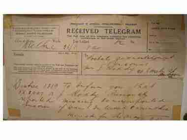
Telegram, Telegram from Minister for the Army to Mrs. Roddy, 5:MMMM, 1941 (estimated)
A hand written telegram from the Minister for the Army to Mrs. J. Roddy to inform her of the capture of VX8007 A.J. RoddyCOMMONWEALTH OF AUSTRALIA POSTMASTER GENERAL's DEPARTMENT/ RECIEVED TELEGRAM/ Typed section of Telgram: FUNDS MAYBE QUICKLY, SAFELY AND/ECONOMICLY TRANSFERRED BY/ MONEY ORDER TELEGRAM/ PLEASE TURN OVER./ RECIEVED TELEGRAM./ The first line of this Telegram contains the following/ particulars in the order named/ Office of Origin, Words, Time Lodged, No/ (hand written)Melbourne, 36/1, 9a, 12 , 2./ Top right hand corner: T.G. 42 (not stamped)/Office Date Stamp/sent at...../Ch'nl No..../ By ....(all of which have no markings)/ Mid Document: Remarks. This message has been recieved subject to the/post and telegraph act/ and regulations./ The time received at this office is shown at the end of this message./The date stamp indicates the date both of lodgement and of reception/ inless otherwise shown after the particulars/ of the time lodged.// Beside this is: TO (hand written) Postal acknowledgement/ Personal/ Mrs. J. Roddy 20 Emily St/Merbein 6365.// Under this handwrittten in ink: Distre 1319 To inform you that/ VX8007 A J Roddy Previously/ reported missing is now reported/ Prisoner of War Interned Carinthia/ Minister for the Army/ 9.25 ww11, pow, a j, roddy, vx8007, 1941, carinthia -
 Orbost & District Historical Society
black and white photograph, July 1922
A new bridge over the Snowy River at Orbost was opened for traffic on June 20th 1922. It was designed for future joint use by road and railway traffic, but it was only used for road traffic. During the last few years the condition of an old suspension bridge [the 1893 bridge] which was the only vehicular crossing between the town of Orbost and the railway station, caused much concern. The structure was of timber, except for the wire suspension cables of its central span of about 100 feet. A design was prepared in 1914 for a permanent bridge with five spans of 85 feet composed of plate girders on concrete piers. With great increase in the price of steel work during the war, the cost of this design became prohibitive, and the need for a new structure becoming urgent, alternative proposals were investigated. As a result the present design was adopted as providing a sem-permanent bridge at moderate cost. The new bridge spans the river about 160 feet upstream from the old bridge on a slight skew, the piers being at an angle of 80 degrees with the centre line of the bridge. It has a camber of about 2 feet 5 inches in its total length of 527 feet. ( information from Newsletter March 2014 - Lois Crisp) The photograph shows Mrs James Cameron cutting the ribbon at the opening of the Orbost Pile Bridge in 1922. This second bridge, was built by the Victorian Railways and the Country Roads Board. Constructed at a cost of 35,000 pounds and used second-hand girders from the Flinders Street- Spencer Street viaduct. On July 4 1922 it was officially opened by Mrs James Cameron. Unfortunately, her husband, who had long championed the building of the bridge so that it would be ready for the railway to continue to the border, was too ill to attend the ceremony. In fact, James Cameron died on July 13 after a long and severe illness (ref. S.R.M. 20.7.1922). There is a section of this ribbon in the collection - Registration No. 366. This is a pictorial record of a significant event in Orbost's history.A black / white photograph of a pile bridge with a suspension bridge behind it. There are many people standing on the bridge.on back - "Opening of Pile Bridge - 1922"snowy-river-bridge ceremonies cameron-mrs -
 Eltham District Historical Society Inc
Photograph, Peter Pidgeon, Grave of John and Mary Murray, Eltham Cemetery, Victoria, 5 April 2021
Irish-born John Murray and his wife Mary (daughter of Thomas Sweeney) married in 1849 and settled in Eltham North. John and Mary were amongst the earliest inhabitants of Eltham. John was a farmer and their block of about 80 acres, called ‘Laurel Hill’, was on the eastern side of the Diamond Creek, extending east to beyond Zig Zag Road. It was later extended southward by the purchase of a further 60 acres. He is recorded as a supporter on the petition for a school in Eltham and he served on the National School Board of the Eltham school. John died in 1867 and is buried in Eltham Cemetery with Mary and with two of their grandchildren. Their eldest son Johnnie inherited the property. Then in about 1902 his younger brother James purchased about 50 acres on the western side of the Diamond Creek immediately opposite Laurel Hill, extending west to slightly past Wattletree Road. Eltham North Reserve now lies just beyond the southern boundary. James built a family home on top of the hill on the northern boundary, together with a dairy and milking shed and a food cellar. It is thought that the barn with stables was already there. When Johnnie died in 1912, the two properties (though severed by both the creek and the railway line) effectively merged. The land was worked as an orchard with apples, pears, quinces, and possibly apricots and peaches. Later it became a dairy farm. By 1986, almost all the land had been sold off for residential subdivision and the house had been condemned as unfit for habitation. John's grandson Jim retained a small portion of the land and built a new house. He kept the old one as a storage shed, but it was demolished after he died in 1993. The very old barn is still standing. Located in the Roman Catholic section In Memory of John Murray Who died Dec. 1867 aged 50 years Also his wife Mary Murray Who died 7th Sep. 1909 aged 76 years And of their grandchildren Thomas and Mary Ellen DrainBorn Digitaleltham cemetery, gravestones, john murray, mary ellen drain, mary murray, thomas drain -
 Eltham District Historical Society Inc
Photograph, The Stokes family home and orchard blanketed with snow, corner Nyora and Eucalyptus roads, Eltham, Winter 1951, 1951
Taken from outside the family home on the southest corner of the intersection of Nyora Road and Pitt Street with Eucalyptus Road. Frank Stokes first traveled to the district by train in 1944 to find land with the intention to establish an orchard. By chance he met Arthur Bird of Bird Orchard (bounded by Pitt Street, Eucalyptus Road and Wattle Grove) and they got talking over their common interest. Arthur put Frank up for the night and pointed out the land, part of Crown Allotment 15, Section 5, Parish of Nillumbik (CA15) somewhat diagonally opposite Bird Orchard. Frank bought the land and for the next two years would travel by train from Melbourne to Eltham every weekend establishing Stokes Orchard and building a home for his family, which they eventually moved into in 1946. Marjorie North remembered well the winter of 1951, when she took children, including son John together with the Shallard and Squire children “in the Austin A40 up the Main Rd., Eltham to farmer Bell’s property alongside the Eltham College. They were able to make a snow man and throw snowballs. (Diamond Valley News, August 5, 1986.p.42) In the mid 1970s the Shire of Eltham divided the orchard up into numerous rate-able parcel lots, which became affordable for Frank. As a consequence Stokes Orchard was turned into a housing development by Macquarie Builders and marketed as the Stokes Orchard Estate in two stages; Stage 1 encompassing Scarlet Ash Court, Ironbark Close and Peppermint Grove bounded by Nyora and Eucalyptus roads c.1976 and Stage 2 encompassing Stokes Place, Orchard Way, The Crest and The Lookout bound by Nyora and Diosma roads c.1979. The development of Orchard Way, The Crest and The Lookout did not proceed as planned due to the lack of the sewer along Diosma Road and so many of the proposed lots were incorporated into five-acre parcels instead.Representative of the orchard growing areas of Eltham. One of the rare times it has snowed in Eltham.Digital file only - Digitised by EDHS from a scrapbook (containing commercially printed photos of digital scans) on loan from Beryl Bradbury (nee Stokes), daughter of Frank Stokes.1951, beryl bradbury (nee stokes) collection, eltham, nyora road, eucalyptus road, snow, stokes family home -
 Eltham District Historical Society Inc
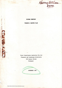
Document - Report, Tract Consultants Australia Pty Ltd, Eltham Cemetery: Towards a Master Plan, Nov 1987
BACKGROUND The Eltham Cemetery is of historic significance to the Eltham area. The Trust was established in 1858 and has administered and maintained the cemetery from that date right up to the present. Among the more noteworthy graves is that of Sir William Irvine, a former State Premier and Chief Justice of Victoria. Eltham Cemetery is surrounded on three sides by urban development. Montsalvat Artists Colony adjoins the remaining (eastern) side. A Joint Select Committee of Parliament called the “Mortuary Industry and Cemeteries Administration Committee" (MICA) enquired into the land requirements at the Eltham Cemetery in 1986. The MICA recommendations contained in its 1986 report are included in the Appendices attached to this report. Although the recommendations have not been adopted by the Government it is interesting to note that the MICA report recommended the use of the bulk of the land for cemetery purpose. In June of 1987, the Cemetery Trust was expanded to include additional members from the Eltham Community by the Minister for Health. At the same time, he instructed the Trust to resolve the land requirement issues. As a result of this Ministerial direction, Tract Consultants has been instructed by the Eltham Cemetery Trust to prepare a report addressing the issues raised in the Minister's letter (see Appendix 1) to the Trust. Principally, the study will examine options available for development of the Cemetery. These options will explore possible boundaries, cemetery design, vegetation, the overall environment, landscaping and financial planning for the Cemetery operations. Appendix 2 details the Cemetery Trusts Terms of Reference for the Study. Before commencing the study in detail, additional basic information was sought; viz: a) sub-soil and rock analysis; and b) feature survey by a Licensed Surveyor. The results from both exercises are included as appendices to this report. Section three includes a summary of the findings along with other analytical results. Also: Eltham Cemetery - planning bewteen 1859 to 1860; research by Alan Sheehan April 2015, collated by Harry Gilham, EDHS, April 2016 (2 pages) PROV Guide 5: Cemetery Records (8 pages), printed 7 May 2014Development of Eltham Cemeteryeltham cemetery trust, master plan, mica, montsalvat, mortuary industry and cemeteries administration committee, tract consultants -
 City of Moorabbin Historical Society (Operating the Box Cottage Museum)
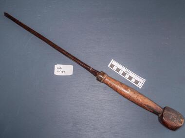
Tools, Screwdriver large, c1900
A screwdriver is a tool, manual or powered, for turning (driving or removing) screws. A typical simple screwdriver has a handle and a shaft, and a tip that the user inserts into the screw head to turn it. The shaft is usually made of tough steel to resist bending or twisting. The tip may be hardened to resist wear, treated with a dark tip coating for improved visual contrast between tip and screw—or ridged or treated for additional 'grip'. Handle are typically wood, metal, or plastic and usually hexagonal, square, or oval in cross-section to improve grip and prevent the tool from rolling when set down. The handle and shaft of screwdrivers have changed considerably over time. The "Perfect Pattern Handle’ screwdriver was first manufactured by HD Smith & Company, which operated from 1850 to 1900. Screwdrivers were probably invented in the late 15th century, either in Germany or France when Screws were used to construct screw-cutting lathes, for securing breastplates, backplates, and helmets on medieval jousting armor—and eventually for multiple parts of the emerging firearms, particularly the matchlock. The jaws that hold the pyrites inside medieval guns were secured with screws, and the need to constantly replace the pyrites resulted in considerable refinement of the screwdriver. The screwdriver depended entirely on the screw, and it took several advances to make the screw easy enough to produce to become popular and widespread Canadian P.L. Robertson, though he was not the first person to patent the idea of socket-head screws, was the first to successfully commercialize them, starting in 1908. In Portland, Oregon, Henry F. Phillips patented his own invention, an improved version of a deep socket with a cruciform slot, today known as the Phillips Screw. Phillips offered his screw to the American Screw Company, and after a successful trial on the 1936 Cadillac, it quickly swept through the American auto industry. A main attraction for the screw was that conventional slotted screwdrivers could also be used on them, which was not possible with the Robertson Screw. A large steel screwdriver with worn wooden handlepioneers, early settlers, market gardeners, moorabbin, bentleigh, cheltenham, brighton, tools, craftsman, carpenters, , blacksmiths, builders, farmers, metalwork, woodwork, screws, philllips head screwdrivers, h.d.smith & co usa, p.l. robertson, henry f.phillips , oregon, canada, american screw company, -
 Eltham District Historical Society Inc
Photograph, St Andrews Primary School, Eltham Heritage Tour, 24 May 1992, 24/05/1992
ELTHAM HERITAGE TOUR The Society excursion on 24th May 1992 was arranged by David Bick, leader of the team carrying out the Shire's heritage study. David selected a number of sites or buildings identified in the study, some of them lesser known components of the Shire's heritage. The tour commenced at the Eltham Shire Office at 10.00 am. Travel was by private car and mini-bus with stops at about twelve locations for commentary by David.It included a short walk in Hurstbridge and lunch at Kinglake. Highlights of the tour included: - 10 am Leave from Shire Offices - 3 Important Trees - A Physical Link to Eltham's First Settlers - Toorak Mansion Gates - A Surviving Farm House - An Intact Circa 1900 Main Street - First Settlers - Gold Miners, and Timber-getters - An Early Hotel - A Pioneering Homestead - Changing Eltham Shire - 20th Century - 4 pm Afternoon Tea and Finish Tour Extract from ELTHAM CULTURAL HERITAGE TOUR (Newsletter No. 85, July 1992, by Bettina Woodburn) "At St Andrews we noted the old and new schools, the Anglican Church, the Hall, the Bakery and the pub – still a popular watering and eating place. Climbing towards Panton Hill the soil was not rich and supported only scarce growth. Perfunctory prospecting and mining had taken place in this area, though not with the diligence applied at Research. Again we saw the ingredients of a settlement, this one organised by Government, the Hotel, the Store, the School. Down from Memorial Park the School grounds had original tree planting and the School Bell dedicated to Maud Rattray who died in 1922. There is a new Hall and opposite in the grounds of the Church and Sunday School a modest Memorial Cross of granite with inscriptions and in memory of four 'fallen comrades'. This small section of the main road retained the small village atmosphere; although the population had increased there had been little alteration."Record of the Society's history and activities and highlighting various aspects of the Heritage Study undertaken by David Bick used to create the future heritage overlay for the Shire of Eltham and later Nillumbik Shire.Roll of 35mm colour negative film, 4 stripsKodak Gold 100 5095shire of eltham historical society, activities, heritage tour, st andrews -
 4th/19th Prince of Wales's Light Horse Regiment Unit History Room
Medal, 1939-45 Star
The 1939-45 Star may be awarded for those who undertook operational service during World War II. Eligibility The 1939-45 Star is awarded for service between 3 September 1939 and 2 September 1945 for: a period of six months (180 days) operational service for RAN and Army personnel and RAAF non-air crew personnel a period of two months operational service for air crew personnel a period of six months service at sea for Merchant Navy provided at least one voyage was made through one of the specified areas of active operations The 1939-45 Star is awarded to Australian Civilian Personnel who served afloat with the United States Army Small Ships Section between 8 December 1941 and 2 September 1945. Eligibility is the same as that for Merchant Navy personnel. See required evidence to support a claim. The Medal The 1939-45 Star is a six–pointed star of yellow copper zinc alloy. The obverse has a central design of the Royal and Imperial cypher, surmounted by a crown. The cypher is surrounded by a circlet containing the words ‘The 1939-45 Star'. Stars issued to Australian personnel have recipient names engraved on the plain reverse. The Ribbon The 1939-45 Star ribbon has three vertical stripes of dark blue, red and light blue. The dark blue stripe represents the Naval Forces and the Merchant Navy, the red stripe the Armies and the light blue stripe the Air Forces. Clasps The ‘BATTLE OF BRITAIN' clasp was awarded to eligible air crew involved in the Battle of Britain. When the ribbon is worn alone a gilt rosette ribbon emblem is worn to denote the award of the ‘BATTLE OF BRITAIN' clasp. The ‘BOMBER COMMAND’ clasp was introduced in 2012 and is awarded to eligible Bomber Command aircrew. When the ribbon is worn alone the standard silver rosette ribbon emblem is worn to denote the award of the ‘BOMBER COMMAND’ clasp. Full size and miniature medals with ribbons. Miniature has clasp : Battle of Britainnilmedal 1939-45 star -
Glen Eira Historical Society
Article - Grand Union Tramway Junction, Balaclava Road and Hawthorn Road
This file contains three items. 1. A three-page Caulfield Conservation Study of the Balaclava Road/Hawthorn Road Tramway Crossing, undertake by Andrew Ward and dated September 1994. Study includes a brief history of the junction and a statement of significance. Study also includes Four black and white photographs of the junction and of architectural details of the tram tracks. 2. A letter from the Conservation Manager of the National Trust of Australia (Victoria) to the manager of the Planning Section for the City of Glen Eira, dated 15/06/2001 and attached to a six-page Classification Report. The letter informs of the Classification of the Grand Union Junction at the intersection of Balaclava and Hawthorn Road by the national trust, signed by Conservation Manager Ian Pausacker. Classification Report includes details such as the date of construction, a statement of significance, history of the junction, physical description of the junction and the condition of the junction at the time of writing. Report also includes a map of the Melbourne Tram Network drafted by Keith Kings and dated 01/005/1956, with illustration of the layout of fifteen tram depots, and updated aerial illustration of the Grand Union Junction, and a further map of Melbourne Tramways developed by North Melbourne Electric Tramways and Lighting Co. and Prahran and Malvern Tramways Trust, drafted by Keith Kings and dated January 1914 with illustrations of three tram depots. 3. Two articles from the Caulfield Leader written by Aaron Langmaid and dated 13/02/2007 and the Melbourne Bayside Weekly dated 21/02/2007 written by Joanne Sim, both concerning the Grand Union Junction. The article from the Caulfield Leader includes a picture of Executive Officer of the council of Tramway Museum of Australia Craig Tooke in front of the intersection. The article from the Bayside Weekly includes a picture of a tram passing through the junction and a brief history of the junction and tram network in Caulfield. The article also refers to twp local tram shelters at the intersection of Dandenong Road and Alma Road and also Orrong Road and Balaclava Road.caulfield, caulfield conservation, study, balaclava road, hawthorn road, grand union junction, ward andrew, tramway crossings, transport, acland street, caulfield racecourse, tram tracks, race events, event, tram routes, thorough fares, melbourne and metropolitan tramways board, prahran and malvern tramway trust, prahran and malvern district tramways, caulfield electric tramways, caulfield city council, architectural detail, city of glen eira, balaclava road and hawthorn road intersection, balaclava road and hawthorn road junction, dandenong road, glenhuntly road, four-way tram junctions, access covers darling road, cast metal access covers, hadfields patent, caulfield park, tram systems, tram networks, heritage, tramway heritage, kings keith, tram depots, glenhuntly depot, maps, glen eira, melbourne electric tramways, north melbourne electric tramways and lighting co., prahran and malvern tramways trust, caulfield leader, bayside weekly, tooke craig, tourist attractions, grand union tramways junction, caulfield junction, cable car tramways, tram shelters, building, sheds, alma road, orrong road, caulfield electric line, balaclava junction, elsternwick railway station, caulfield station, caulfield station loop, tram services, transport establishments, thoroughfares, buildings, structures, establishments, parts of buildings or structures, documents, commercial industry, sites, historic sites, melbourne bayside weekly -
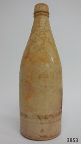 Flagstaff Hill Maritime Museum and Village
Ceramic - Stoneware Bottle, Dundas Pottery, 1856-1910
This bottle is part of the John Chance Collection of shipwreck artefacts. The Dundas Pottery works were established in 1828 by William Johnstone in partnership with John Forsyth and John Mc Coll. Located where the Forth and Clyde Canal joined the Monkland Canal, North of Glasgow. Johnstone sold the pottery in 1835 to Robert Cochran and James Couper. Mc Coll was retained as manager until 1837when in 1839 Cochran & Couper sold the pottery and purchased the St Rollex Glass Works. George Duncan took over briefly but died in 1841, with the pottery possibly being run by his widow Helen and a potter named Alexander Paul. James Miller was the manager at the time and he bought the pottery in 1856, in partnership with John Moody. Miller's long and careful stewardship of the pottery saw success from the export market which allowed him to purchase the North British pottery in 1867 until 1874 when it was sold. In 1875, Miller, in partnership with John Young, leased part of Caledonian Pottery, naming it Crown Pottery, however, it burned down in 1879. In the early 1880s, Young extended the pottery and named it Milton Pottery. Miller’s son, James W., became a partner in Milton pottery in 1905. James Miller Snr died in 1905 and the company continued as a limited liability company, being sold to the Borax Consolidation Ltd in 1929, but it was unsuccessful and Possil pottery purchased some of the company's equipment before it finally closed in 1932. From 1828 until the James Miller period of circa 1856, the pottery produced salt-glazed stoneware for the local industrial trade; mainly bottles and drain pipes. James Miller produced various bottles, whisky and acid jars, casks, butter crocks, jam jars and domestic wares in Bristol glaze. He streamlined the water filter manufacturing, which had become a speciality of the pottery, and a dedicated section of the pottery was created solely for their production, which was exported worldwide. A significant item of salt-glazed ceramic stoneware made by the Dundas potteries in Scotland who were renowned for making quality ironstone pottery. The bottle that was in common use throughout the British colonies and America for the containment of ale The bottle is also significant as it was recovered by John Chance, a diver, from a wreck on the coast of Victoria in the 1960s-70s. Items that come from several wrecks along Victoria's coast have since been donated to the Flagstaff Hill Maritime museum collection by his family Illustrating the level of historical value the subject item has.Beige salt glazed stoneware, bottle with discolorations above base. Manufacturer's oval Inscription lozenge stamped near base. Stamp: [symbol of concentric ovals], text within the symbol "PORT DUNDAS POTTERY COY." and "GLASGOW". Stamp:[Symbol - square with short vertical line in centre of base line]flagstaff hill, warrnambool, flagstaff hill maritime museum, maritime museum, shipwreck coast, flagstaff hill maritime village, great ocean road, john chance, stoneware bottle, pottery, port dundas pottery, william johnstone, bottles, shipwreck artefact, stoneware, ironstone, bottle, glasgow, antique bottle -
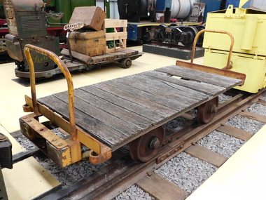 Puffing Billy Railway
Explosives Wagon, unkown
This 2 foot 6 inch (762mm) gauge wagon was used for carrying explosives and was used with the Greenbat Battery loco. It was donated to the Walhalla Goldfields Railway on long term loan in 2013 along with a large quantity of narrow gauge trollies and light rail from Orica’s now closed munitions factory in Melbourne’s western suburbs. Orica - Deer Park Munitions factory Orica Deer Park in Melbourne’s west has been used since circa 1875 for various forms of manufacturing and storage of chemicals. Although the site is bounded by Ballarat Road, Station Street, Tilburn Road and the Western Ring Road, the current entry point for industrial operations is situated at Gate 6 of Tilburn Road. Operations include: • a specialty chemicals facility producing products for mining services operations • quarry services • other chemical manufacture activities. The Deer Park factory complex The factory complex is of historical significance for the major role it played in Australia's manufacturing and mining industries through the development of progressively more efficient and safer explosives. It also contributed to wartime production in ammunition, initiators and the development of synthetic ammonia production and construction of the Defence Explosives Annexe No 5 (later the Albion Explosives Factory) during World War Two. The factory complex is also of technical significance for the unusual and specialised design of many of the buildings and structures, both in the layout of the works and the individual design of buildings. Blast protection and safety measures such as mounds around the buildings, 'cleanways' and buffer zones between production areas were employed extensively. A characteristic of many production buildings was the elimination of cavities where explosive compounds could lodge. The combination of concrete barriers and light-weight construction was designed to direct explosion debris away from operators or other buildings. The narrow gauge tramway, which ran through the explosives section, is a rare survivor of nineteenth century materials-handling methods. Historic - Industrial Narrow Gauge Railway - Wagon for carrying Explosives at the Orica - Deer Park Munitions factory, Deer park, Victoria, Australia Wagon for carrying explosives made from Timber and steelwagon for carrying explosives, puffing billy, industrial narrow gauge railway, orica - deer park munitions factory, explosives wagon -
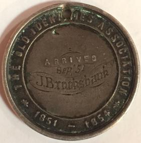 Old Colonists' Association of Ballarat Inc.
Photograph - Photograph - Colour, John Brooksbank's Old Identities' medal
The Old Identities' Association was a forerunner of the Old Colonists' Association Ballarat. John Brooksbank was a very early arrival to Ballarat in September 1851, which was not long after the discovery of gold at Ballarat. J. Brooksbank lost a dog in 1857 "LOST from the Half Way House, Smythe's Creek Road, a black bloodhound and kangaroo dog. Anyone detaining him after this date will be prosecuted. J. BROOKSBANK" (Ballarat Star, 30 December 1857) Another very early identity in Ballarat, James Oddie, advertised the sale of J. Brooksbank's hotel in 1860: "JAMES ODDIE & CO. have received instructions from the Mortgagees, to sell I by auction at their rooms, Dana street, on Thursday, 20th September, at twelve o'clock, All that desirable properly known as the , Halfway House Hotel, Together with all that piece or parcel of ' land situate in the parish of Cardigan and county of Grenville, containing 34 acres 1 rood 26 ½ perches, part of allotment 1, section 6, of said parish, situated on the Ballarat and Smythesdale road, and recently occupied by Mr J. Brooksbank. The property consists of a spacious stone building one story high, strong and substantially built, the internal fittings and arrangements are neat and complete. The house possesses all requisite accommodation for a respectable country hotel. In addition are stockyards, stables &c, all well and securely fenced. Terms at Sale. (Ballarat Star, 20 September 1860) Four years later Brookbank was selling his hotel in Lyons Street Ballarat: "RARE OPPORTUNITY.-FOR SALE the BLACK BULL HOTEL, Lyons street. The proprietor of the above hotel being about entering into another line of business, begs to call the attention of parties looking for a safe and profitable investment, the above having undergone thorough repairs, and is now in good working order and doing a fair share of business. The conditions will, be half cash, balance six, nine, and twelve months. Apply, J. Brooksbank, proprietor, on the premises. (Ballarat Star, 22 October 1864)Colour photograph of a sterling silver medal relating to The Old Identities' Association 1851-1854. The medallion, belonging to John Brooksbank, has a drilled hole at the top suggesting it was worn by the owner at some stage in its life. The medal has been engraved: Arrived "Sep 51 J. Brooksbankold identities association, old colonists' association ballarat, c.a. welch, silversmith, numismatics, j. brooksbank, medal