Showing 1102 items
matching information map
-
 Vision Australia
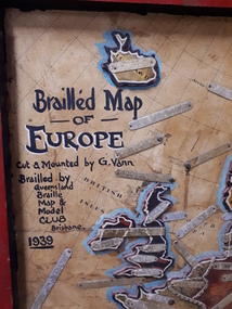
Map - Object, Brailled Map of Europe, 1939
... and handwritten note "Information about maps gratis from Miss E Southern... and handwritten note "Information about maps gratis from Miss E Southern ...This tactile map of Europe was created in 1939, and brailled by the Queensland Braille Map and Model Club. Cut and mounted by G. Vann with geographical inforamtion provided by Miss E Southern. The Queensland Braille Map and Model Club was a volunteer organisation which produced tactile maps from the 1920s to the late 1940s. These were sent as presents to schools, organisations and missions for people who were blind or vision impaired around Australia, New Zealand, Syria, India, Canada, Papua New Guinea and Africa. Due to free postage of Braille obtained by Tilly Aston and her compatriots, the maps were transported gratis within Australia and at a cheap rate overseas. When this map was made, East Prussia, Danzig and the Levant States were all separate countries. Some information about each country (name, area in sq miles and population) is written on a small door on the right hand side, which can be opened to reveal the same information in Braille. At the base is a braille and handwritten note "Information about maps gratis from Miss E Southern "Kingsley" George St, Brisbane. "For lending to the Blind" is written at the base of the wooden frame.1 paper attached to wooden mount with metal labels, on the right hand side a small door with country information on the front and opens to reveal the same in Braille. queensland braille map and model club, r.f. tunley -
 Melbourne Tram Museum
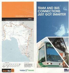
Pamphlet, Yarra Trams, "Tram and Bus connections just got smarter", 2008
... system, its route, timetable information and has a map... route, timetable information and has a map of the route ...Pamphlet - two fold DL full colour printed on semi gloss paper, titled ""Tram and Bus connections just got smarter", introducing Smart Bus route 903 from Mordialloc to Altona connecting with 9 different bus routes. Gives details of the smart bus system, its route, timetable information and has a map of the route on the rear. Dated 2008.trams, tramways, smart bus, buses, public transport, maps -
 Bendigo Historical Society Inc.
Document - NEWSPAPER PAGES (BENDIGO ADVERTISER, 1971), 1971
... c. Lake Eppalock page - maps and information. Advertiser 10.... As for a. but Advertiser 25/9/71 c. Lake Eppalock page - maps and information ...a. Bendigo Tramways Amended Timetable (to operate from 27/9/1971). Advertiser 27/9/71 b. As for a. but Advertiser 25/9/71 c. Lake Eppalock page - maps and information. Advertiser 10/4/71 d. Classified Ad cutting 25/9/1971 - reference to Bendigo Historical Society Museum ( & Shakespeare Society) 23/01/2020 Item missing AVdocument, newspaper, bendigo theme -
 Ballarat Tramway Museum
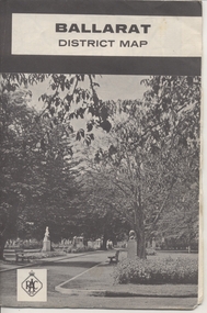
Map, Royal Automobile Club of Victoria, "Ballarat District Map - RACV", c1966
... and district maps and information, and a list of sporting..., Ballarat and district maps and information, and a list of sporting ...Yields information about the extent of Ballarat in the early to mid 1960's shows the tram lines and other rail lines in the district.Printed street map titled "Ballarat District Map", published by the RACV, showing the central part of Ballarat, Ballarat Outlets, streets, principal attractions, Ballarat and district maps and information, and a list of sporting and entertainment facilities. Has the tram lines shown dotted, does not run out to Sebastopol or the Lydiard St North terminus. Each map in the bottom left hand corner has the numbers "1166", possibly indicating the date.trams, tramways, map, ballarat, racv, railways -
 Ballarat Tramway Museum
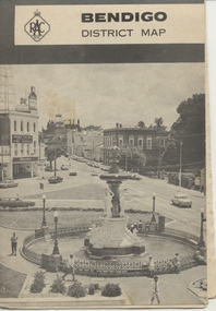
Map, Royal Automobile Club of Victoria, "Bendigo District Map - RACV", c1971
... Printed street map titled "Bendigo District Map", published... Parade Ballarat Ballarat goldfields Trams tramways Map Bendigo ...Printed street map titled "Bendigo District Map", published by the RACV, showing the central part of Bendigo, Bendigo Outlets, streets, principal attractions, Bendigo and district maps and information, and a list of sporting and entertainment facilities. Has the tram lines shown dotted, only shows the full extent of the Golden Square line. The main map has the number "0171" in the bottom left hand corner, indicating the publication date.in ink on the Bendigo Outlet map, "3/4" along bottom edge.trams, tramways, map, bendigo, racv, railways -
 Melbourne Tram Museum
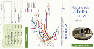
Pamphlet, Yarra Trams, "Help us to build a better service", 2001
... , and information provided. Has a map of the Yarra tram routes, or network... Trams tramways Yarra Trams Livery Surveys Map Pamphlet - four ...Pamphlet - four fold DL - gloss paper, titled "Help us to build a better service", asking Yarra Trams (prior to amalgamation of M>Tram) passengers, survey, about the appearance of the new Yarra trams livery, inside and outside, security cameras, and information provided. Has a map of the Yarra tram routes, or network. Include contact number and logos. Dated 2001 and signed by Steve MacDonald as CEO of Yarra Trams.trams, tramways, yarra trams, livery, surveys, map -
 Bendigo Historical Society Inc.
Document - PETER ELLIS COLLECTION: NATIONAL FOLK FESTIVAL, 16th - 20th April, 1992
... ), Festival Map, the Programme and Dance Programme Information. Also... & Garran Halls Information for Visitors, Map of Australian National ...Literature from the 26th National Folk Festival held in Canberra on the 16-20 April 1992. Program containing General Information, the Performers (including the Emu Creek Bush Band), Festival Map, the Programme and Dance Programme Information. Also leaflets: Visitors Guide, Program, Embassies in Canberra, University Halls of Residence Bruce Burton & Garran Halls Information for Visitors, Map of Australian National University, and an article titled 'Real Folk' with information about performers. Pioneer Performers Series Information Sheet April 1992 contains Introduction, Current Available Items, Current Projects, Forthcoming Events and Ramblings of a Modern Day Collector.entertainment, music, national folk festival, peter ellis collection, australian national university, 26th national folk festival canberra 1992, the monaro folk music society, emu creek bush band, wongawilli colonial dance club inc -
 Melbourne Tram Museum
Ephemera - Map - Timetable, Melbourne & Metropolitan Tramways Board (MMTB), "Map and timetable of Melbourne Tram and Bus Services", March 1952
... Map provided information about Melbourne's tramway network...Melbourne Tram Museum 8 Wallen Road Hawthorn melbourne Map ...Map provided information about Melbourne's tramway network in 1952. At base of map - timetable of all night trams and bus services. On rear index to routes, 1st and last services, time of Sunday am services, Latrobe St. services and photo of Wattle Park. The conversion of Bourke St to electric trams marked up. Copy 1 - has been marked for hypothetical extensions in blue pencil mainly in the northern and western suburbs. In particular note the Ballarat Road and South Road markings. Copy 2 - has been marked up for newer route numbers, following the opening of the Bourke St services and additional route numbers on the Essendon Depot lines. Demonstrates the provision of information about Melbourne tram services.Fold out map (10 sections - 2 high x 5 wide), coloured of Melbourne's Tram and Bus routes, route numbers, rail lines, municipalities boundaries and location of major places of interest. melbourne, tram and bus services, mmtb, buses, trams, routes, timetables, all night services -
 Warrnambool and District Historical Society Inc.
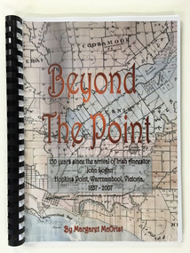
Booklet, Beyond the Point, 2007
... . The front cover has a reproduction of an 1891 map of Warrnambool... information superimposed on the map. The back cover is black. The book ...This book was written in 2007 by Margaret McOrist to mark the 150th anniversary of the arrival in the Warrnambool area of John Logan. It is a sequel to a 1991 book, ‘Clotted Cream and Mangels’ which told the story of John Logan and his wife Mary Gardner. They lived at Hopkins Point, Warrnambool and the book, ‘Beyond the Point’ tells the story of the Logan descendants. When the farm land was sub-divided and sold the nearby beach was named ‘Logans Beach’. This book is of considerable interest as it tells the story of the descendants of important early settlers, John Logan and Mary Gardner. The area where they first settled is now of major interest as Logans Beach (named for the Logan family) is the well-known whale watching area. Southern Right Whales return to this beach each year and the females calve and remain up to three months at this beach, making it an important ‘whale nursery’. This is a soft cover book with black plastic ring binding and clear plastic sheets covering the front and back paper covers. The front cover has a reproduction of an 1891 map of Warrnambool and district with the title of the book and other information superimposed on the map. The back cover is black. The book has 101 pages and contains information on the Logan families who lived at Tooram in Allansford and their descendants. There are many black and white and colour photographs, diagrams, maps and family trees. Front Cover: ‘Beyond the Point, 150 years since the arrival of Irish ancestor, John Logan, Hopkins Point, Warrnambool, Victoria, 1857-2007, by Margaret McOrist’. john logan and mary gardner, hopkins point, logans beach, tooram, history of warrnambool -
 Ballarat Tramway Museum
Map, Ministry of Transport, "Metropolitan Transport Services Map - Melbourne - Tram and Bus Services", c1970
... telephone numbers for further information. Notes the map... various telephone numbers for further information. Notes the map ...Pocket size - folded - public transport map of Melbourne, printed in colours showing the bus, train and tram routes around Melbourne. Has a cover price of 10c. No printing date shown, but c1970 as distances are still in imperial, the West gate bridge is shown, though so is the Williamstown Ferry. Gives telephone numbers in 6 digit figures. Lists route numbers for trams, tramways board bus services and private services. Gives various telephone numbers for further information. Notes the map is a combined effort of the Tramways Board, Victorian Railways, Bus Proprietors' Association and the Transport Regulation Board. Single sheet of paper folded in 9 x 3 folds.trams, tramways, melbourne, map, public transport, routes -
 Bendigo Historical Society Inc.
Document - ALBERT RICHARDSON COLLECTION: SOUTH NEW MOON MINE EAGLEHAWK
... Two-page typed document with map, detailing information... document with map, detailing information on the South New Moon Gold ...Two-page typed document with map, detailing information on the South New Moon Gold Mine on the Garden Gully line of reef. Information includes the location, depth of shaft, steel poppet legs, engine house, air compressor, battery, company ownership, battery. The shaft The 'Walker and Coy' winding engine of the later company together with poppet heads was removed later to the South Virginia company between Napier and Market Street, Eaglehawk. Gold production from both companies who owned the mine was 257,498 oz.'.bendigo, mining, south new moon gold mine -
 Melbourne Tram Museum
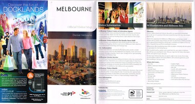
Pamphlet, Public Transport Victoria (PTV), "Melbourne Official Visitor Map", 2012 to 2019
... , Myki, and visitor information. Has two maps - Melbourne..., Myki, and visitor information. Has two maps - Melbourne ...Set of 6 pamphlets - folded to DL size - full colour - each titled "Melbourne Official Visitor Map" giving location of various Melbourne attractions, transport information, ticketing, Myki, and visitor information. Has two maps - Melbourne and the inner suburbs and the CBD + Southbank area. .1 - 14 - fold - published 2012 - 13 - has standard tram and rail maps as well. .2 - 14 fold - published 2013 - 14, also has a map of Melbourne laneways. .3 - 12 fold - published 2016 - has D 3523 on front cover outside Flinders St Station. .4 - 12 fold - published 2015 - map of City Centre and Inner Melbourne, .5 - 12 fold - published 2017 - as above. .6 - 12 fold - published 2019 - as abovetrams, tramways, melbourne, ptv, maps, tramways, railways, tram 3523 -
 Melbourne Tram Museum
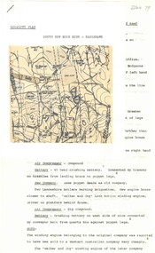
Document - Opening of Box Hill Extension Route 109 Press documents, Ministry of Transport, May 2003
... the following items .2 - 10 fold DL pamphlet providing map, technical... providing map, technical information and tram stops. .3 - A2 folded ...Produced for the opening of the Box Hill Extension, 2 May 2003, extending the tram line from Union Road Mont Albert to Station Street Box Hill. Became known as Route 109 - Port Melbourne Box Hill.Provides the background to the 2003 extension of the Mont Albert tram to Box Hill.Documents - mainly folded to A4 enclosed within a card folder prepared for the event. .1 - folder - folded card to hold the following items .2 - 10 fold DL pamphlet providing map, technical information and tram stops. .3 - A2 folded sheet for the Route 109 project - introduction by the Minister for Transport, Peter Batchelor .4 - A3 folded sheet giving background history to the area .5 - 2 page Press Release dated 2/5/2003 .6 - A4 sheet with CD containing a photo of the 30/9/1916 Opening by Mr. A Bailey trams, tramways, new tramway, box hill, opening, route 109, mont albert -
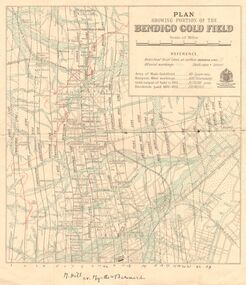 Bendigo Historical Society Inc.
Map - DEPARTMENT OF MINES VICTORIA : PLAN SHOWING PORTION OF THE BENDIGO GOLD FIELD
... through the western side of the map. Additional information... through the western side of the map. Additional information ...Department of Mines Victoria. Plan showing portion of the Bendigo Gold Field. On the back is written, in ink, J. J. Tyler 1937 Northern Area. (He was a teacher at Bendigo High - see donation notes). Across the bottom of the map is written ' M. Hill cr. Myrtle & Barnard' .The named reef lines have been numbered with ink across the bottom of the map. The gullies have been coloured with green pencil and a red pencil line is drawn through the western side of the map. Additional information: anticlinal axial lines at surface, alluvial workings, shaft sites, area of Main Goldfield, Deepest mine workings, Gold output of field to 1935, and Dividends paid 1870 - 1935.bendigo, gold mining, bendigo gold field. gold mining. tyler, j. j. -
 Melbourne Tram Museum
Pamphlet, Public Transport Corporation (PTC), "Free City Circle Tram", mid 1990's
... , the Melbourne Town Hall, Visitor Information, Walking Trails, a map..., the Melbourne Town Hall, Visitor Information, Walking Trails, a map ...Pamphlet - eight fold to DL size, full colour, titled "Free City Circle Tram" with a photo of a City Circle tram passing Flinders St station. Has information about Melbourne trams, the Melbourne Town Hall, Visitor Information, Walking Trails, a map of the route, with places of interest shown. Map shows the service via Spencer St. Has photos of 2013 and 909 as well. Has the City of Melbourne, Department of Infrastructure and Public Transport Corporation logos. Possible produced during the mid 1990's given the various logos used. .1 - As above, but with Yarra Trams and State Government logos See Reg Items 1387 and 2703 for other versions.trams, tramways, city circle, melbourne, public transport corporation, ptc -
 Melton City Libraries
Map, Streets of Melton, 1963
... Name appears on 2013 Melton information map JANG Place... information map JANG Place KURUN – jang KIRKTON Drive Name ...MELTON’S STREETS Heritage Week 2014 What’s in a Name? Alphabetical List Aboriginal place names, Early Family Names and landowners, Agricultural, Shop and Commercial premises, Places and Events Melton & District Historical Society Street Naming Project 1972 – c 1998 Suburb Name – KURUNJANG - Kirkton, 1972, Brookfield, West, 1988 Melton and Town Centre - A joint collaboration with the Shire of Melton and Subdivision Developers ARNOLD Court – Family house - Arnolds Creek ALKEMADE Drive Family – Lime kilns Coimadia ALEXANDRA Street 1902 – Corination of King Edward VII and Queen Alexandra AVIATOR Place Event, location of plane crash – Jimmy Melrose 1936 Adina ?Annibee - Anniba? Agricultural Avon court .. .. BAKERY Square - Location of Jongebloed shop, bakehouse and stables BALUK Place Aboriginal BARLEYCORN Place Agricultural BILLING Place Name of Jimmy Melrose Uncle Noel Pemberton Billing BLACKWOOD Drive - Alexander Blackwood 1860c Registrar BARRIES Road C. E. Barrie “Darlingsford” farmer 1911, chaff mill owner BROOKLYN Road Staughton family residence. 1875 – Dismantled c 193? CAHILL Drive Family - Glenville Dairy CAMERON Court Family Canopus Place ? CANALLAN Drive Early Surveyor CAMPBELL Court Aviation – Melrose passenger 6th July 1936 CARBERRY Drive Michael, early landowner family CAREW Court Edward and Michael. Royal Hotel. Vera (Carew) Forran Singer - Opera CASEY Court Family CASHIN Court Family CHEVIOT Court Agriculture, breed of sheep CHESNEY Road was re named ( Minns Road being duplicated c 1973) CHRISTINA Crescent Christina McPherson, daughter of James and Mary Mary McPherson. Died 1955 aged 85 years COLLYER Close a deleted street (parallel to Yuille) re-used CORRIEDALE Road Breed of sheep CORR Court Teacher at first school, landowner CROXTON Court Name of the Hornbuckle and Knox family home DALEY Court - William Daley and family 1865 Bootmaker High Street DARLINGSFORD Boulevard - Name of early homestead Thomas B Darling 1853 DJERRIWARRH Court - Parish County of Bourke - very early map. DODEMAIDE Place Early land owners - Melton Football Team had 6 brothers playing c 1924 DONALD Court McPherson family 6 generations in Melton in 1936 DOUGAL Court DUNCAN Court .. .. DUNVEGAN Circuit Home of the McPherson family, castle Isle of Skye Name of bluestone house Smith Street (now at Willows) EMIL Court Jongebloed family EXELL Avenue Farming family Melton Sth- Closer Settlement 1907 EXFORD Road Exe former name of the Werribee river FARMER Court Name of early postmistress FERRIS Road John Ferris Farmer HANNAH Close First name of Hannah Watts – midwife HAYBALE Place Agricultural HELDER Court Early surveyor J Helder Wedge map HEWSON Street Winston Hewson Shire Engineer – check title c 1960 HENRY Street Township map c 1860 HESTON Street Heston Phoenix – C.J. Melrose plane HILDEGARDE Court Jimmy Melrose’s mothers name HOMESTEAD Close HORNBUCKLE Cres Farmers. Three members of family - Shire Presidents HURLEY Street Farmers IAIN Court Descendent of James and Mary McPherson JAMES MELROSE Drive Name appears on 2013 Melton information map JANG Place KURUN – jang KIRKTON Drive Name of the McPherson family home Toolern Vale Road KIRWIN Street Michael early landowners (deleted for freeway construction) KILPATRICKS Road Deleted when Barries Road was extended across Station Rd KOROROIT Court Early map, Parish of Kororoit. Creek name KNOX Circuit Family – Hornbuckle “Croxton Park” KURRUNJANG Drive Aboriginal name for people of the red earth – Suburb name Lara Place ? LLOYD Court Garage owners High Street. Laura lived to 100 years D 1955 LUBY Court John Luby – Crown Grant Land Title LITTLE Court MANNING Avenue Richard, hotel owner 1891 MARGARET Drive McPherson family McDONALD Street Melton South family name McKENZIE Street Township c1860 MORROW Street Early name MOWBRAY Crescent Name of English Melton, popularly believed origin of Melton MYERS Court Early setters c 1866 Crown Grant Land Title NIMMO Street Early name NIXON Street Name submitted by Mary nee Nixon Collins c1985 OLDERSHAW Road Early builder PALMERSTON Street Early township map c 1860 PEART Court Early name PENNYROYAL Avenue Plant growing by the creek. Early name used for the Toolern Toolam Creek PINKERTON Street Family name and early street map PINNACLE Crescent Agricultural - type of wheat PHOENIX Circuit C.J. Melrose Phoenix Heston Plane 2013 map PRATT Family PRIOR Court PYKE Place Brothers – early settlement 1838 RADFORD Court Land owners and business operators. Former Royal Hotel Grocer High Street demolished 1970 RAGLAN Court Hotel 19th century Lord Raglan RALEIGHS Road Oliver Reierson family (Norweigen) Shopkeeper – Dressmakers RIDDELL Drive (misspelt Riddle) Resident and land owner RODERICK Road McPherson family – a re occurring name ROLLAND Court Jones family ROSS Court Daniel. Landowner. Agnes Ross music teacher RUSSELL Court Robert. Early land surveyor of Melton 1853 RYAN Court Family early landowner. Member of the 1862 Road Board SHEBLER Place Augustus early Melton resident – Golden Fleece Hotel SHEEPFOLD Court Farming SHERWIN Court Sherwin Street earliest Township map– became Golf course SMITH Street Early township map. STRATHULLOH Circuit Strathtulloh Homestead. STAUGHTON Street Family – LARGE land owners Strachan ? SWANEY Court Marie Swaney earlier resident of Strathtulloh. SUTHERLAND Family name TOOLERN Street TOOLAM – TOOLERN Creek TULLIDGE St Road marked on 1861 map UNITT Street Early Township c 1860 WALLACE Square Cr Jack Wallace 5 terms as President 46 years unopposed WATTS Court Hannah Watts – midwife, cottage hospital WALSINGHAM Name of house of Minns family. From Walsingham Norfolk England WESTLEY Place Name of Jimmy Melrose Percival Gull Plane WESTLAKE Drive Early resident WHICKHAM Street Family Name Melton South WILSON Road Albert, Melton South YUILLE Street William Cross, early landowner, Rockbank run Zoomed in section of Melton Streets including Church and High Streetlandscapes of significance -
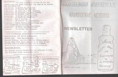 Bendigo Historical Society Inc.
Document - JAMES LERK COLLECTION: BENDIGO CENTRAL BOTTLE CLUB NEWSLETTER
... map) and information on two of the seven vineyards in area... being once a main thoroughfare to Bendigo (with sketch map ...Bendigo Central Bottle Club Newsletter - James Lerk Collection (April 1976 by deduction). Reference to William Brude store owner/wine and spirit merchant. Involved in partnership in London Brewery and owned Norfolk Brewery - includes list of various bottles owned and used by William Bruce. Reference to Sheepwash being once a main thoroughfare to Bendigo (with sketch map) and information on two of the seven vineyards in area by 1855 - A. Derivan (sic) De Ravin and William Jones, Wine Merchant; article on Bendigo Breweries - reference in it to Albion Brewery, Phoenix Brewery (Pheonix sic), Lucan St Brewery, Thunder & Co, Thunders Sandhurst Brewery, A Thunder & Co, Tankard Malting Co, Bendigo Cognac Distilling Coy, Norfolk Brewery, BB Brewery, Union Brewery, Dublin Porter Brewery, Hindmarsh Brewery, Liverpool Brewery, Edinborough Brewery, Adelaide Brewery, the City Brewing Co, Anchor Brewing Co, Kent Brewery, Alpine Brewery, Sandhurst Brewery; Page listing know Bendigo aerated water manufacturers who used the Hamilton Patent - W Bruce, J Heffernam (sic) ,Hefferman?, G Pritchard, Hunter Bros, J Wharton, F G Beard, A Phillips, T Davies. -
Federation University Historical Collection
Document, Zelda Martin, Central Victorian Goldmining towns - Boom Towns or Ghost Towns?, c1996
... information to Chapter 1 plus extra re towns and maps. Sections... information to Chapter 1 plus extra re towns and maps. Sections ...Zelda Martin was a PhD candidate at the University of Melbourne.[.1] 4th item in light blue display book titled Research Approach/Overview of Chapters/Confirmation of Canditure/Chapters1,2,3&4 of proposed thesis. *Twenty-seven page article on Victorian goldfields towns titled: Central Victorian Goldmining Towns - Boom Towns or Ghost Towns. The article was written during the author's PhD study. It outlines the context methodology, and resources and the chapters of the proposed thesis: (1) Central Victorian Goldmining Towns - The Context (2) Contemporary Views of the Factors Necessary for Town Growth (3) Outward Manifestations of Town Growth (4) The Trappings of Government (5-9) The Main Towns and Their Hinterland. [.2] 5th item in Light Blue display book as above item. *Chapter 1 of proposed thesis titled 'Pick, Shovel and Tin Dish Mining.' Covers in Section A: Central Victoria - Pre 1851: Aborigines in Central Victoria, Squatters, and Government. Section B: The years 1851-1854: The Early Gold Rushes, Government Reaction, Township Surveys, Legislation, Town Development, Local Government and Early Settlement. [.3] 6th item in Light Blue display book as above item. *2A of proposed thesis titled 'Contemporary Views of the Factors Necessary for Town Growth'. Similar information to Chapter 1 plus extra re towns and maps. Sections: Introduction, Context of Place - Geographical Towns Listed, The Context of Time - Pre1851 Aborigines, Governance of Port Phillip, The Squatters, The Villages of Central Victorian Highlands, Conclusion, Condensed Version of Chapter2B. [.4] 7th item in Light Blue display book as above item. *Chapter2B of proposed thesis. Sections: Area of Research, Schools, Banks, Newspapers, Progress Association, Town Development - Sandhurst (Bendigo), Ballarat, Castlemaine,, Maryborough, Ararat and Stawell. [.5] 8th item in Light Blue display book as above item. *Chapter 3 of proposed thesis titled 'Outward Manifestations of Town Growth'. Sections: Introduction, Contemporary Writing, Educationalists, The Bankers, The Townsfolk, Current Theory, General Theories of Urban Development, and Conclusion. [.6] 9th item in Light Blue display book as above item. *Chapter 4 of proposed thesis titled 'Trappings of Government' Sections: Introduction, Early Government Attitudes to Mining and Town Development, Law and Order, Township Surveys, Legislation, Local Government, Transport and Communication, The People and Lobbyists. [.7] 10th item in Light Blue display book as above item. *'The Rise and Fall of Central Victorian Goldmining Towns'. Includes a map showing main Goldfields, a table showing towns and villages at two points in time - 1857 and 1871; a Bibliography of Primary and Secondary Sources. [.8] Resource No1. Black display book titled Local Towns 1 : Alma: *Brief history *Directory *Maps Amphitheatre / Mountain Hut: *Brief History Post Office Directory Ararat: *Brief History *Post Office Directory 1869 - Alphabetical Listing by Occupation *Ararat - Prominent Citizens of 1858 *Langi-Morgala Museum Avoca: *Brief History *Excerpts from 'Avoca The Early Years', Margery and Betty Beavis; pg1 - Beginnings; pg11 - The Midas Touch; pg25 - Local Gold Escorts; pg27 - A Town is Born; pg51- The Administration of Justice; pg53 - The Ways of the Law; pg61 - News of the Day; pg65 - A Time to Play; pg72 - Land Ownership *Post Office Directory (Bailliere's) 1869 *Tourism Map and Information of area *Historic Avoca - A 5.5km Tour *Avoca & the Pyrenees Region - information pamphlet Ballarat: *Early History of Ballarat - Ballarat Historical Society, Publication No.1: origin of the name; Ballaarat - the Beginning; Fabulous Yields from the Ballaarat Goldfield; *Streetscape Lydiard Street. *Hand drawn map showing Leigh River, Old Portland Bay Road, plaque on road to Colac; etc. *Newspaper article re 'The Theatre Royal' ( which stood in the vicinity of the current Owen Williams store) - 'The News'15/04/1998 *Article - 'Ballarat's Mechanics' Institute Lives On' Ballarat Courier, 14/09/1985 *Article - Standing the Test of Time' The News 17/11/1993 re The Mechanics Institute & picture of the Reading Room *'Ballarat a Study of a City, Phyllis Reichl, pub. Nelson, 1968; no.3 place, time and people field studies series *Investigator Vol.33 No.2, 1998 Geelong Historical Society. Article on pg75 describes Ballarat in 1861 *Folded poster - 'Ballarat 100' a history of telegraph communication, pub. Telecom. Beaufort (Fiery Creek): *Brief history *Post Office Directory [.9] Resource No.2 Black Folder Titled Towns cont.No2 Bendigo (Sandhurst): *'Family & Local History at the Bendigo Library - 1851-2001 150 years of gold'. *Bendigo Government Camp in 1853 illustration; key to sketch and names of Government officers stationed there *Excerpts from 'Bendigo and Vicinity' Adolph Haman *The Bendigo Goldfield Registry - pgs 1-7 Introduction *Excerpt: 'Breaking the Grip' *Excerpt: The Most Go-Ahead Place *Excerpts from 'History of Bendigo' - anti license agitation; laying out of town; proposed railway; gold calls and dividends; the Sandhurst Municipality; journalism *Bibliography Blackwood: *Excerpts from 'Aspects of Early Blackwood - The Goldfield, the Landmarks, the Pioneers' Alan J Buckingham and Margaret F Hitchcock, JG Publishing,1980 Buninyong: *A Brief History *Investigator Vol1 No.2 Feb 1966 Geelong Historical Society. Pg3 - Article re gold escort route - Mt Alexander to Adelaide - (see a simple monument on the Western Highway a few miles out of Horsham. Pg 15 - Ballarat Excursion - re the finding of gold. *Three articles published by Buninyong and District Historical Society Inc: (Magpie Exploration; Finding Gold In The Green Hills; Magpie Exploration; Burnt Bridge to Cargarie to Mt Mercer) *Copies of newspaper articles/items *Buninyong Street Directory Carisbrook: *In the Beginning There Was Carisbrook *The History of the Carisbrook Racecourse Carngham / Snake Valley: *Brief History *Directory Castlemaine: *Directory 1865-1866 - Alphabetical and Street *Poster - Castlemaine A Contemporary Guide "The Great Centre" 1866 - A Contemporary Guide to the Fascinating Past *Pamphlet - Castlemaine District Community Hospital *Map - Castlemaine, Maldon & Surrounding Districts *Map and Information - The Dry Diggings Track - a 55kl walk among historic goldfields relics ( Castlemaine Fryerstown Vaughan Mt Franklin Hepburn Daylesford) *Postcard - Former Court House *Directory 1867 - Alphabetical, Trade [.10] Resource No.3 Grey folder Titled Towns 3 Creswick to Maryborough Creswick: *Brief History *Booklet - "Creswick Cemetery Walk" *Booklet - The Buried Rivers of Gold Heritage Trail Creswick *Creswick Historical Museum Information Sheet *Chronological History of Creswick *Alphabetical Directory of the Borough of Creswick *Creswick's Creek Directory 1856 *Historic Creswick Walking Tour *A Brief Account of the Schools of Creswick - Past and Present *100 Years of Railway Travel in Creswick *The Berry Deep Leads *The Spence Home at Jackass Gully in the Creswick State Forest ( William Guthrie Spence - Pioneer) *The New Australian Mine and the 1882 Disaster *Creswick District News, Issue 7, July August 1999 *The Creswick Miners Walk - Information and Map *Maps Chewton: *Brief History *Directory Clunes: *Brief History *Clunes Street Directory Daylesford: *Brief History *Notable Bushfires in Daylesford District Over More Than a Century - "Black Thursday" 1851; 1862; 1899; the Disastrous Hepburn Fire of 1906; 1939; 1944; 1969. *Post Office Directory -Daylesford and Hepburn Dunolly / Inkerman: *Brief History *Directory *Pamphlet - Goldfields Historical Museum *Pamphlet - Historic Dunolly - Victoria's Best Kept Secret *Map of Gold Workings at Dunolly Area - showing where the main gold rushes occurred *Brief History - Inglewood *Directory - Inglewood - Name Occupation, Dwelling Kingower: *Brief History *Directory - Name / Ocupation / Dwelling Linton / Happy Valley / Piggoreet: *Brief History *Directory - Lintons McIvor: *"A History of the Shire and the Township of Heathcote" by J.O. Randell Majorca: *Brief History *Official Post Office Directory 1869 - Name / Occupation/ Address Maldon (Tarrangower): *Brief History Part 1 *Brief History Part 2 *Post Office Directory *List - Alphabetical Order by Names plus Business and Trade (Tarrangower Times Oct/1858) *List - Alphabetical Order by Trade plus Name and Business *Directory - Name / Occupation / Dwelling Maryborough: *Worsley Cottage - built by Arthur Worsley, a contractor in stonework in 1894 [.11] Resource No. 4 Blue Display Book titled Towns 4 Moliagul to Stawell Moliagul: *Brief History *Moligul Legislative Assembly (Voting?) List - Names and Occupations *Moliagul Victorian Post Office Directory 1868 - Name / Ocupation / Address / Comments *"The Welcome Stranger" gold nugget *The Sunday School *The Welcome Stranger Discovery Walk - information and map Moonambel (Mountain Creek) Redbank *Brief History *List of names extracted from advertisments of the Pioneer and Mountain Creek Advertiser 16/02/1861. *Bailliere's Directory 1869 - Alphabetical List of Name / Occupation / Place St Arnaud: *Brief History Sebastapol: *Brief History *Directory 1869 - Alphabetical by Name; plus occupation and address. Browns and Scarsdale: *Brief History *Browns Street Directory - Name and Occupation Smythesdale: *Brief Description *Smythesdale Street Directory -Name and Occupation Stawell (Pleasant Creek) *Brief History *Victorian Official Post Office Directory - Name /Occupation / Dwelling *Chronology - 1841-1920 *Production of gold statistics - 1879 - 1900 *Big Hill *Extracts from "The Golden Years of Stawell". Chapt 1 - Stawell's Coming Out. Capt. 2 - The Gold Rush. Caapt.3 - Cradle of Democracy. Chapt.4 - The Reefs Becomes Stawell. Chapt. 5 - Rushing In. Chapt.6 - The Pioneers. Chapt 7 - The Decade of Optimism. [.12] Resource No. 5: Blue Display Book titled 'Towns Steiglitz to the The Golden Triangle. Steiglitz: Brief History Victorian Post Office Directory 1869 *Map of Steiglitz *List of maps relevant to Steiglitz history *Information 6 tables of data from "Reports of Mining Surveyors Talbot (Back Creek) Brief History Taradale: Post office Directory 1869 - Name/Occupation/Street. Also list in alphabetical order by Occupation Taradale *Chronological Reference to Taradale Mines *Water - The Coliban System of Waterworks *Joseph Brady *The Syphon Tarnagulla (Sandy Creek) *Brief History *Tarnagulla Businessmen Cameos to give depth to advertisments in 'The Tarnagulla Courier' various issues 1864-1871 *Directory - Name/Occupation /Address *List - Name/Business/Trade Wedderburn (Koorong) *Brief History *List - Name/Occupation The Golden Triangle: *The Early Rushes - Wedderburn / Moliagul / Sandy Creek - Tarnagulla / Jones Creek - Waanyarra / Kingower / Dunolly - Goldsborough / Inglweood *Census of 1857 - Population / Occupations *1858-1871 - A Time of Consolidation- Wedderburn / Moliagul / Sandy Creek- Tarnagulla / Arnold *Census 1871 - Population *Information gleaned from the census data - Demographics / Population / Occupations / marital / Birthplace / Religion / Literacy/ Occupation and Housing Cameos *Graphs - Birthplace of settlers /Male-Female Ratio / Married males / Children under 15 as Percentage of Population / Religion *Census 1857 - Statistical data *Maps *Bibliography [.13] Resource No. 6 - Black Display Book Information and Research in Central Victoria including: *Banking - Research from ANZ Bank Archives *Institutions - also includes articles listed from the Ballarat Times Newspaper *Australian mining History Association - A.M.H.A. Bibliography *Australia's Mining History * Bibliography - Land Surveys Victoria - *1853 Administration (Statistics and Other) includes: schools / ministers of religion / police / military / local administration / licences for sale of spirits / distances between various Victorian gold fields. * Victoria Government Gazette (Copy) - N0. 116, 12/12/1854 includes: Gold Felds Commission of Enquiry & No. 85, 15/09/1854 - Addresses presented to the Lieutenant Governor (Sir Charles Hotham) during his tour through the Gold Fields of Victoria,1854. Addresses on behalf of : the people of Bendigo; Members of the Church of England, Bendigo; Members of the Wesleyan Church on the Bendigo Gold Fields; Bendigo Gold District General Hospital; the Bendigo Prospecting Association; Committee of the Bendigo Local Exhibition; Bendigo District Medical Association; Coloured Americans Resident at Bendigo; German Inhabitants of Bendigo; Landowners, Inhabitants, and Miners of Castlemaine; Inhabitants of Forest Creek; Inhabitants of Heathcote and Gold Miners of McIvor; Residents and landholders of the District of Bacchus Marsh; Inhabitants of Kilmore and Vicinity. *Gold Fields Correspondence 1853: letter from Lieutenant Colonel Valiant, (Officer commanding the Troops in Victoria) to the Lieutenant Governor re threatened disturbance at Sandhurst (Bendigo) regarding the Gold License Fee. * Extracts from a book "Victoria" re Gold Fields Commission of Enquiry involving mainly Ballarat and Castlemaine and a chapter titled 'A Tour to the Victorian Gold-Fields' *Lists of central Victorian newspapers - listed by date published 1851to 1874; by first date available to State Library. *A list of cities and towns showing County, population in 1861 &1871, and municipal status. [.14] Resource no.7. Black display book. *Reference: Papers presented to Parliament Victoria - 1859-1860 4 volumes - relevant sections copied. Contains information on Branches of Government. General / Finance / Gold / Gazette / Commission and Warrant / Statistic. *Gold Fields Act. In accordance with the Act the gold fields are divided into six districts - Ballaarat, Castlemaine , Sandhurst, Avoca, Ararat, and Beechworth.. Official staff in each gold district consists of a Resident Warden, Wardens, Wardens' Clerks, Bailiffs, Chinese Protectors, Chinese Interpreters, and Mining Surveyors. *Gold Receiver *Gaols *Police magistrates and Clerks of Petty Sessions, etc. *Field Branch *Immigration and Emigration Overland - Chinese - 1859 *Population on the Goldfields *The Geological Survey - The Government Geologist is assisited by staff from four branches - the office Branch; the Publishing Branch; the Field Branch and the Museum Branch. *Commission to Enquire Into Sludge dated 10/02/1859 (Some sections copied) - Report to the Honorable Chief Commissioner of Public Works, Melbourne re the mode of carrying the sludge from the puddling mills in Sandhurst without interfering with the drainage of the town and the roads in the neighbourhood. [.15] Resource No.8: Camel display book titled Resource No. 8. Aborigines *Lists of book titles - +"Readings in Victorian prehistory" +"The Aborigines of Port Phillip" +Aboriginal languages and clans" +"A History of the Port Phillip District" +"Langi Ghiran 1: Aboriginal Rock...." +"Koorie History: sources for aboriginal studies in the State Library of Victoria", ed. Tom Griffiths, Melb. Friends of the State Library, 1989 +"The Public Lands of Australia Felix"; settlement and land appraisal in Victoria1834-91 with special reference to the Western Plains", J.M.Powell, Melb. Oxford University Press 1970 +*Bibliography of the Victorian Aborigines' from the earliest manuscripts to 31st December 1970, Massoa, Aldo, Melb. Hawthorn Press, 1971 +"Aborigines in Colonial Victoria, 1836-1886", M.F. Christie, Sydney University Press, 1979 +"Urban and Industrial Australia: readings in Human Geography" ed J.M. Powell, Melb. Sorrett Pub. 1974 *Extracts: -Processes of Pioneer Settlement - The Squatting Occupation of Victoria, 1834-60. J.M. Powell -Areal Variations in the Class Structure of the Central-Place Hierarchy. P. Scott - Volume1 and Volume 2: Notes Relating to the Habits of the Natives of Other Parts of Australia and Tasmania. Compiled from various sources for the Government of Victoria by R Brough Smyth. John Curry, O'Neil, Melb. 1st pub. Melb. 1876. p31-45 - Numbers and Distribution of the Aborigines in Victoria -Victorian Aborigines 1835-1901 - A Resource Guide to the Holdings of the Public Record Office, Victoria; published by the Government Information Centre 1984. *History of the Aboriginal Artefacts Displayed in the Daylesford Museum. F. G. Powell (4 page pamphlet) *Letter to Zelda Martin from Peter Lovett, Cultural Officer, Ballarat & District Aboriginal Co- Operative, 05/02/1997 *Map: Ian Clarke Victorian Tribunal Boundary Map - Clans of Central Victoria. *Victorian Rock Art and Mythology - Article about Mount Langhi Ghiran and myths of the Tjapwarong people. *Two Aboriginal myths relating to the Grampians - 'The Monster Emu' / 'The Aquisition of Fire', by the Aborigines in the Grampians Areas *Article titled (chapter 8) Ballarat - information re camping sites in the region. Lake Wendouree / Lake Burrumbeet (includes a myth) / Mt Bunninyong / Lal Lal / Pitfield / Mount Elephant / Mount Egerton / Meredith / Lake Goldsmith / Lake Learmonth / Ercildoune *Notes on the Aborigines of the Wider Ballarat Region plus European names=Aboriginal names. John Morris 26/07/1995 *Role of Aborigines in Town Development in Central Victoria. Mentions Native Police Force est. in Port Phillip 1842 and Central Board for Aborigines est. 1860 *The Grave of King Billy. (Frank Wilson) Pamphlet. *Camping Places in Central and Northern Victoria. Article re Lake Burrumbeet site. *Programme for the Unveiling of Memorial Cairn for Edward Stone Parker 1802-1865. Note portrait not accurate. Accurate portrait is available in the book "A Successful Failure A Trilogy The Aborigines and Early Settlers", Edgar Morrison, Graffiti Publications, 2002. * Large envelope addressed to Mr G Netherway containing newspaper cuttings regarding the life of Edward Stone Parker, the unveiling of the Memorial Cairn as mentioned above, articles titled 'Episodes from Our Early Days' (Edgar Morrison, Yandoit)- The Black's School, A School At Last and The Final years. Also a typed page titled 'Historical Background to E.S.Parker's Career. Includes an interesting tale titled 'When the cat lay doggo' re laying power leads for the unveiling ceremony at the memorial site. [.16] green display folder titled 'Research Aids' *List of references to Commissioners' & W'ardens' Reports (formerly held at La Trobe Library Archives, now at Public Records Office [PRO]). Indicates town referred to / date of report / name of camp if different to town. * Archive information re Anglican Records *Movement around the Goldfields - Miners and Storekeepers - usefulness of newspapers in providing information - areas covered - Castlemaine, Maldon, Ararat, Stawell, Tarnagulla, Dunolly. *Port Phillip /Victoria Directories 1839/1867 - Chronological list of Directories included in this series. *"Notes on the History of Local Government in Victoria" A.W. Greig Melb. University Press 1925 - Photo-copied extract p5-p40. (Source - Deakin University Library) - Introduction by W.Harrison Moore. Section 1 - Development in New South Wales Before Separation. Section 2 - Development in Victoria After Its Separation from New South Wales. Hand written notations: 'roads, markets, and local government 1855 on' ;'opportunity of squatters in parliament' and 'opportunities of matters in parliament p33' * Notes on the Establishment of Surveyor General's Department 1851and Commissioner of Crown Lands and Survey. * Newspaper articles from The Argus, 1849, re the discovery of gold in the Pyrenees region. * Excerpt - a report on schools - A.B.Orlebar, Inspector; re the need for permanent school buildings rather than tents. *Excerpt from - 'Approaches to Urban History', Sean Glynn: The Case for Caution * Except from - 'The Urban Sprinkle', Weston Bate: Country Towns and Australian Regional History *Reference- 'The History of Land Tenure in the Colony of Victoria', John Quick. References the Haines Land Bill, land tenure and Land Leagues. [.17] Light blue envelope folder titled 'Birtchnell's Ballarat, etc. Directory 1862 *Contains various directories for Smythesdale, Buninyong, Clunes, Brown's and Creswick. [.18] Red envelope folder no.2 titled Victorian Gazetteer *Selected pages from 1869 Victorian Gazetteer on A4 paper (with a handwritten note questioning if some pages are from 1868 Victorian Gazetteer as appears to be different sizes - A3 pages.) Information includes locations and descriptions of towns, hotels, banks, communications and populations. (Does not include names, residences and occupations) [.19] Red Envelope folder titled Bailliere's Official Post Office Directory 1868 (or1869 or a mixture of both?) *Preface *Contains a selection of pages of towns highlighted in yellow in the the index *Work on this directory was commenced in 1867. *Information includes: Municipalities - mayors and councilors; lists of towns naming male inhabitants and their occupations. [.20]Yellow manila folder titled Post Grad Seminar Presentation 1996 *Gives some background to Zelda Martin's proposed thesis and why she chose the topic Gold Mining Towns Boom or Bust [.21] A3 display book - No. 1A * A list of 'Relevant Newspapers collected: The Tarrangower Times and Maldon Advertiser (first published 1858) Includes dates 1858-1867. The Mount Alexander Mail. Includes dates 1854-1866 The Tarnagulla Courier. Includes dates from1864-1871 Dunolly and Burnt Creek Express. Includes dates from 1862-1871 * Selection of newspaper pages from The Mount Alexander Mail 1854 to 1856, mostly showing advertisements for businesses and services provided to that community. [.22] A3 display book - No. 1B * Selection of newspaper pages from The Mount Alexander Mail 1857 to 1866, mostly showing advertisements for businesses and services provided to that community. [.23] A3 display book -No. 2 * Selection of newspaper pages from The Tarnagulla Courier 1864 to 1871, mostly showing advertisements for businesses and services provided to that community. [.24] A3 display book - No. 3 *Selection of newspaper pages from The Tarrangower Times (and Maldon and Newstead) Advertiser 1858 to1867, mostly showing advertisements for businesses and services provided to that community. [.25] A3 display book - No.4 * Selection of newspaper pages from The Dunolly and Burnt Creek Express; and The Dunolly and Betbetshire Express 1862 to 1871, mostly showing advertisements for businesses and services provided for that community. [.26] A3 display book - No.5 Includes: * Bryce Ross's Diggings Directory. Includes instructions for using this directory. This directory was used by "all persons having connexion or desiring to communicate with 'working parties, private friends, or Stores at the Diggings." As a directory for each area wwas completed it was published in each month's issue of Bonwick's "Digger's Magazine." Years c1852/1853. This Directory commences first at the head of Forest Creek. Includes a directory for Bendigo and Ballarat. Of interest at the end of the Bendigo and Ballarat directory is a list of the number of storekeepers, butchers, doctors, smiths, eating houses, lemonade sellers and chapels. * The Castlemaine Directory and Book of General Information Comprehending Glass's Model Calendar for the Two Years 1862 and1863. "zelda martin, victorian goldfield towns, bendigo, castlemaine, ballarat, maldon, stawell, ararat, maryborough, creswick, avoca, heathcote, banks, bank of australasia, union bank of australia, government camp, sandhurst, water supply, tarnagulla, talbot, back creek, mountain creek, police court, carisbrook, dunolly, thompson's foundry, charles clacy, anthony trollope, robert cecil, mount alexander, urbanisation, national schools, education, govenrment, industry, railway, transport, settlement, land settlement in central victoria, steiglitz, joseph brady, the new australian mine, berry deep leads, william guthrie spence, creswick state forest, arthur worsley, worsley cottage, the welcome stranger, moliagul, moonambel, redbank, st arnaud, sebastapol, brown's, scarsdale, clunes, chewton, daylesford, bushfires, inkerman, inglewood, kingower, lintons, happy valley, piggoreet, mcivor, majorca, tarrangower, taradale, the coliban system, the syphon, sandy creek, wedderburn, koorong, arnold, jones creek, waanyarra, the golden triangle, census 1857, blackwood, buninyong, durham lead, magpie, carngham, snake valley, alma, amherst, daisy hill, amphitheatre, mountain hut, beaufort, fiery creek, counties, population, gold fields commission of enquiry1854, william westgarth, gold license fee, lieutenant colonel valiant, administration of the victorian gold fields, commission to enquire into sludge 1859, e.s. parker, edward stone parker, edgar morrison, mount franklin protectorate, dja dja wurrung, memorial cairn, franklinford, mt franklin memorial cairn, jajowurrong, dja dja wurung, tjaowarong, wothowurong, assistant protectors, daylesford museum, buluk, rock art - grampians, aboriginal mythology - grampians, aborigines, first nations people, mount franklin, aboriginal artifacts, lake burrumbeet, native police force, central board of aborigines, yandoit, commissioners' reports, wardens' reports, port phillip/victoria directories 1839-1867, local government - victoria 1853/1854, surveyor general's department - 1850's, victorian schools 1850's, a.b.orlebar, haines land bill, william charles haines, wilson gray, land tenure, land leagues, victorian gazetteer, the tarrangower times and maldon advertiser - 1858-1867, the mount alexander mail 1854-1866, the tarnagulla courier 1864, dunolly and burnt creek express 1862-1871, bryce rose's diggings directory, the castlemaine directory 1862-1863 -
 Orbost & District Historical Society
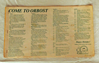
brochure, Come To Orbost, c 1980's
This brochure was produced as a tourist guide to Orbost.This item is a useful research tool.A magazine/brochure for use as tourist information. It contains the history, maps and touring routes of the Orbost district.tourism-orbost -
 Orbost & District Historical Society
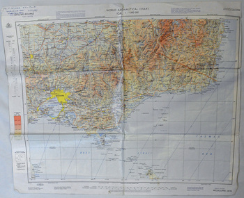
map, 1985
An aeronautical chart is a map designed to assist in navigation of aircraft. Using these charts and other tools, pilots are able to determine their position, safe altitude, best route to a destination, navigation aids along the way, alternative landing areas in case of an in-flight emergency, and other useful information such as radio frequencies and airspace boundaries. World aeronautical charts have a scale of 1:1,000,000 and cover relatively large areas. Orbost Aero Club began in 1969 with Basil Dowie as Chair, David Nixon as Secretary/Treasurer. The group went into recess from 1977-1991 closing in 1997. The mid 1960s were boom years in flying training in Australia and the number of Aero Clubs grew rapidly. The Club played a significant role in the establishment of the small airport at Marlo and in the ongoing operation and development of the airport over the years particularly for patient transfer by aerial ambulance. The Orbost Aero Club Club played a significant role in the establishment of the small airport at Marlo and in the ongoing operation and development of the airport over the years.A laminated map of eastern Victoria. A World Aeronautical Chart. It shows elevations, longitude etc and is designed for pre-flight planning as well as pilotage. Top left hand corner - D.F.N.Nixon VH-FWD 12 Kristine Ct Cheletenham 27/7/87orbost-aero-club aeronautical-map -
 Orbost & District Historical Society
information sheet, Welcome to the Shire of Orbost, 1992
This was possibly produced for an open day in the centenary year. The Shire of Orbost was a local government area about 380 kilometres east of Melbourne. The shire covered an area of 9,347 square kilometres and existed from 1892 until 1994. Originally, Orbost was part of the Bairnsdale Road District which was created on 30 April 1867. Splitting away as part of the Shire of Tambo in 1882, Orbost was first incorporated as a shire in its own right as the Shire of Croajingolong on 30 May 1892. It received its present name on 17 February 1893. On 3 January 1913 part of its western riding was annexed to Tambo as its Cunninghame Riding. On 2 December 1994, the Shire was abolished, and merged with City and Shire of Bairnsdale, Shire of Tambo, most of the Shire of Omeo and the Boole Boole Peninsula from Shire of Rosedale into the Shire of East Gippsland. This is a useful reference tool.Two stapled pages of printed information. On the front page is the logo of Orbost Shire Council. There is information on the role of the Shire Councillors for 1992/93. It has a map of the council building.orbost-shire-council -
 Orbost & District Historical Society
pamphlet, Snowy River Mail, Happy Holidays
This pamphlet was probably produced for use in the Slab Hut (Orbost Visitor Information Centre)These pamphlets are useful reference tools and reflect the tourism history of the local area.Two single page tourist brochures, printed on both sides and folded in the middle. They are white with pink and blue print. and have a map of East Gippsland and descriptions of places to visit.tourism-orbost -
 Orbost & District Historical Society
book, Snowy River Mail as "Mail" Print, Princes Freeway Orbost Section, 2117.1 : 1976 2117.2 : 4.9.2013
The Snowy River Bridge, Princes Freeway, Orbost, Victoria was opened by the Hon. J A Rafferty, Minister for Transport, 25 November 1976. ‘The bridge was built at a cost of A$2.4 million and is the first of four bridges to be built as part of the 8.4 kilometre freeway bypass of Orbost. Construction of the bridges commenced in January 1975, with an expectation to open the bridge across the Snowy River as soon as possible. Less than two years later, on 25 November 1976, the bridge across the Snowy River was opened to traffic, allowing the old bridge to be demolished. The remainder of the Orbost Bypass, both the floodplain crossings and the eastern section around the township itself, was declared ‘Princes Freeway’. The newspaper article was written by David Jellie as part of the centenary celebrations of Vic Roads/Country Roads on 4.9.2013. David Jellie was the project engineer for the Snowy River Crossing Project.This book and article contain historical information and details about the construction of the bridges on the Orbost section of the Princes Freeway.2117.1 isaA thin paperbook book which contains a map, history and construction details of the Princes Freeway at Orbost. It has a program for the opening ceremony of the snowy River Bridge in 1976. 2117.2 is an article from the snowy River Mail on the history of the highway. It is dated 4.9.2013.In pencil - 20csnowy-river-bridge jellie-david princes-freeway-orbost -
 Orbost & District Historical Society
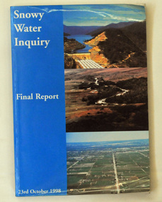
book, Snowy Water Inquiry, Snowy Water Inquiry Final Report, 1998
The Snowy Water Inquiry was commissioned in 1998 with a brief to recommend environmental water release options to the Commonwealth, Victorian, and NSW Governments so that corporatisation of the Snowy Mountains Scheme could proceed. These release options related to the Snowy River below Jindabyne, the Murray River and other rivers associated with the Scheme. The Inquiry objectives were that the recommendations would not adversely impact on water supplies to existing irrigators or the viability of the Snowy Mountains Scheme. (ref snowyhydro.com.au)This report contains information about water allocation and uses of the Snowy River.A book of 160 pp - Snowy River Inquiry Final report 23rd October 1998. Submitted to the Governments of New South Wales and Victoria / Commissioner: The Hon. Robert Webster. On the front cover are three aerial photographs of the Snowy River and Snowy Hydro Scheme. The book contains maps and photographs. snowy-river snowy-hydro snowy-mountains government-inquiry -
Orbost & District Historical Society
folder and photographs, Leatch, May, February 2005
From an interview by Ngaere Donald and May Leatch.Rabbits had been reported in Orbost from 1899. Prior to the introduction of myxomatosis, there was an active export trade in rabbit skins and meat. The main market for canned rabbit meat was the United Kingdom and most skins were exported to the USA.. In Orbost there was a Rabbit Skin Buyers' Shed.1904.1 is a manila folder with printed information and a hand -drawn map. There are four coloured photographs of the Tyndall Street Old Hide Merchants shed with Lachlan Macalaster standing in the doorway. macalaster-lachlan rabbit-skin-buyers-shed hide-merchant -
 Orbost & District Historical Society
map/brochure, Discovering Marlo & The Snowy River Estuary, December 1988
In 1983 the Department of Conservation, Forests and Lands replaced the Department of Crown Lands and Survey, the Department of State Forests and the Ministry for Conservation. This brochure/map was used as tourist information in Orbost.This item is a useful research tool.A folded map/brochure titled "DISCOVERING MARLO & THE SNOWY RIVER ESTUARY". On the front is a photograph of Marlo and the title in yellow print. There is a locality map for access to Corringle beach and the brochure Includes a key to fishing sites and various tourist locations. On the back of the brochure are notes on fishing, wildlife and a boating guide, map brochure snowy-river marlo -
 Ballan Shire Historical Society
Book - Book, Ford - Our Ford Family History, 2015
A history of the Ford Family and descendants, pioneer settlers of the Morrisons/Meredith area in Victoria. Contains photographs, family trees, documents, newspaper cuttings, maps, narratives etc. Black and white only.This book is significant in that it contains valuable historic information on the Ford and Brawn families. The publication is private and intended for the information and interest of family members and others researching the family.Book, soft cover, perfect bound, with a leather look cover and a photograph of family members with a scrollwork surround.ford, brawn, bant -
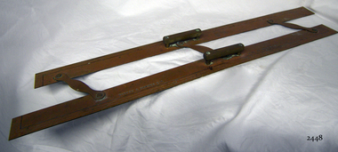 Flagstaff Hill Maritime Museum and Village
Parallel Rule, 1947-1955
History/Context: In 1947, the scientific instrument manufacturing firms of Henry Hughes & Son Ltd, London, England, and Kelvin Bottomley & Baird Ltd, Glasgow, Scotland, came together to form Kelvin & Hughes Ltd. Hughes Company History: Henry Hughes & Sons were founded in 1838 in London as a maker of chronographic and scientific instruments. The firm was incorporated as “Henry Hughes & Sons Ltd” in 1903. In 1923, the company produced its first recording echo sounder and in 1935 a controlling interest in the company was acquired by S Smith & Son Ltd resulting in the development and production of marine and aircraft instruments. Following the London office's destruction in the Blitz of 1941, a collaboration was entered into with Kelvin, Bottomley & Baird Ltd resulting in the establishing “Marine Instruments Ltd”. Following the formal amalgamation of Kelvin, Bottomley & Baird Ltd and Henry Hughes & Sons Ltd in 1947 to form Kelvin & Hughes Ltd. Marine Instruments Ltd then acted as regional agents in the UK for Kelvin & Hughes Ltd who were essentially now a part of Smith's Industries Ltd founded in 1944 and the successors of S. Smith & Son Ltd. Kelvin & Hughes Ltd went on to develop various marine radar and echo sounders supplying the Ministry of Transport, and later the Ministry of Defence. The firm was liquidated in 1966 but the name was continued as Kelvin Hughes, a division of the Smiths Group. In 2002, Kelvin Hughes continues to produce and develop marine instruments for commercial and military use. (See Note section this document for further information on the company's origins)This model parallel map ruler is a good example of the commercial diversity of navigational instruments made by Kelvin & Hughes after world war 2. It was made in numbers for use by shipping after the second world war and is not particularly rare or significant for its type. Also, it was made no earlier than 1947 as the firms of Kelvin, Bottomley & Baird Ltd and Henry Hughes & Sons Ltd who took over from Smith & Sons were not amalgamated until 1947. It can there for be assumed that this ruler was made during the company's transitional period to Kelvin & Hughes from Smith Industries Ltd.Metal parallel rule with Kelvin & Hughes Ltd, Made in Great Britain imprinted, numerous measurements, two handles and 3 hinges.flagstaff hill, warrnambool, shipwrecked-coast, flagstaff-hill, flagstaff-hill-maritime-museum, maritime-museum, shipwreck-coast, flagstaff-hill-maritime-village, parallel rule, kelbin & hughes ltd, metal parallel rule -
 Ringwood and District Historical Society
Poster, Land Sale Advertisement - Pinemont Estate, Ringwood, Victoria - circa 1924
Map of residential allotments for sale, with terms of sale, summary of subdivision features and local services and facilities, and photographs of local street scene and lake (Loughnan's Lake - location not marked), Subdivision includes Wonga Road (later Loughnan's Road), Glenvale Road, Kubba Road, Felix Crescent, Summit Crescent, Pine Crescent, Aurum Crescent, Hygeia Parade, Panorama Avenue, Avalon Grove, Montalbo Road, Cielterre Avenue. Sole Agents T.M. Burke Pty Ltd, 340 Collins Street Melbourne Phones 6294, 6779. Map by S. Callanan, Licensed Surveyor, 107 Elizabeth Street Melbourne. Date of poster estimated from railway services information extract " ... 36 fast electric trains to Flinders Street daily ... proposed electrification to Croydon ..." . Timeline for electrification of Lilydale Line record indicates Box Hill to Ringwood January 1923, Ringwood to Croydon November 1924 (Source: History of Croydon - McGivern, Vol.1 p20). -
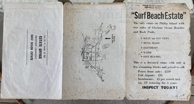 Phillip Island and District Historical Society Inc.
Booklet, Surf Beach Estate, About 1950
W. Davie was a local real estate agentHistoricalBooklet advertising the Surf Beach Estate . Large sheet printed on both sides. One side has map of the estate. other has information about estate, agent and location on Island" Surf Beach Estate" '"The only estate on Phillip island with two miles of Glorious Ocean Beaches and Rock Pools." Prices from only 250 pound.surf beach, real estate, w davie, town planning