Showing 131 items matching "upper kiewa valley"
-
 Kiewa Valley Historical Society
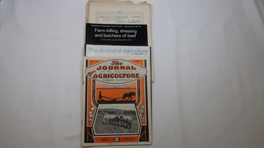
Journals - Department of Agriculture, 1. 1950s and 2. one 1932 & others 1970s
The Kiewa Valley has been a farming district from early settlement of white people. This has continued until the present although the nature of farming has varied over the years. Access to information has improved with transport and technology. The journals kept the farmers informed and up to date.These booklets and journals were one of the few sources of information during the 1950s for the isolated farmers of the Kiewa Valley. The Kiewa Hydro Electric Scheme improved both transport and technology during the scheme's construction from the 1940s. It provided the township of Mt Beauty at the upper end of the valley where shops and schools were constructed, roads were improved out of the valley and the supply of electricity for milking etc. became available. 1. 14 articles each bounded by 2 staples, and each reprinted from Dept. of Agriculture Journal on a particular topic relating to Agriculture. All black & white and c1950s. 2. 4 Journals with colored covers 3 from Victoria Dept. of Agriculture (1932, 1974 & 1975) and 1 from Sth. Australia.1. "J.H.Wallace" hand written top right corner of covers of pamphlets titled 'Diseases Affecting /Young Cattle' and 'Mastitis'. "AHW" hand written top right corner of cover of pamphlet titled ' Grading Land for Irrigation' 2. Nonefarming, agriculture, cattle, pasture, kiewa valley, department of agriculture in victoria, kiewa hydro electric scheme, -
 Kiewa Valley Historical Society
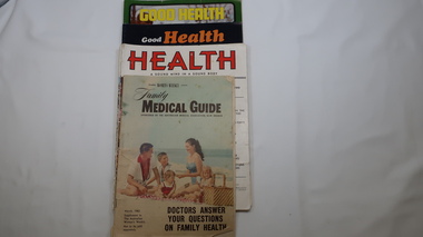
Magazines - Health, 1951, 1952, 1973, 1974, 1962
... in remote areas. The Upper Kiewa Valley situated in a remote part ...These magazines published articles on health for the family giving up to date information with diagrams on common health problems. Magazines with written Information was subscribed to by families at the time as transport and technology was not readily available in remote areas. The Upper Kiewa Valley situated in a remote part of Victoria didn't have easy access to health information. These magazines were available to farmers in the Kiewa Valley and to the workers and their families during the construction of the Kiewa Hydro Electric Scheme from the 1940s. With the introduction of improved transport and technology magazines eventually became less popular as a source of information. They are of interest in that they indicate the medical knowledge of the time and can thus be compared to current day knowledge.11 magazines with colorful covers and the occassional colored picture inside. Each has 32 pages. Periodicals - March, may, July, Sept, Nov. 1951 & jan. 1952. Also - Jan-Feb., Sept-Oct. 1973 and Mar, July-aug. 1974 Also Australian Women's Weekly supplement magazine 'Family Medical Guide' March 1962 with 47 pages. Inserted is a 16 page supplement (also Women's Weekly) dated Aug. 1976 titled 'Poison & First Aidhealth, magazines, medical guide, kiewa hydro electric scheme, kiewa valley -
 Kiewa Valley Historical Society
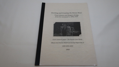
Book - Kiewa River, Stocking and Crossing the Kiewa River by Jan Hunter (nee Chick), 2020
The Chick brothers, Alf, Les and Allan, plus friends, began trout fishing and camping in the Kiewa Valley before the early 1930s. Les continued his connection with the Kiewa River until his death in 1972. Fingerlings were placed in the Kiewa River from the early 1880s. Keegan's Bridge is a crossing near Upper Gundowring and about 4 km south east of Dederang. References to the crossing were made in the early 1900s and a petition presented to Council in 1904 calling for a bridge.The bridge was built and opened in 1907. The photos are of the release of fingerling trout in the Kiewa River, thought to be at Keegan's Bridge. The fingerlings were transported in drums on the back of trucks. The photos are c1940s.The Kiewa Valley has been a popular spot for fishermen, tourists and campers from the 1880s. One of the many attractions has been the excellent fishing along the Kiewa River due to the regular release of fish especially brown trout. This continues to the present day (2020) when a few fish were marked with $$ signs for the lucky fisherman who caught them. This attracts visitors, their families and boosts the economy and dates back to visits at the Tawonga Pub prior to the Kiewa Hydro Electric Scheme.19 page book with black plastic spine and clear plastic cover over the beige paper cover with title , author and black & white photo. Note: In KVHS photo collection there are 4 good quality reproduction photos on photographic paper. These have been produced professionally. These photos of Jan Hunter's are featured on the second page of her book. These also have a letter attached. The book is a pre-research paper & is No 33 of the Albury and District Historical Society Papers. The sub-title is "Trout releases and Keegan's Bridge / from the newpapers, 1882-1935"None on the book but a letter is attached from Jan Hunter, the author as a follow up to the photos she donated. On the photos - On the back: Fujifilm / Fujicolor Crystal Archive / Paper / Production - run codekiewa river; trout; fish; keegan's crossing; keegan's bridge; fingerlings; chick family; camping; tourism -
 Kiewa Valley Historical Society
Photograph - 30 black and white photographs (assorted sizes) plus page from a newspaper and copied article on A4 paper, c1880's c1910 - 1920 (photographs) Newspaper 1961
K2,3 and4 are of the Kiewa River and two of the bridges spanning the river along the valley. K3 and K4 would have been taken in the 1880's and show the type of trees and plant growth along the river prior to land clearing for farming. K5 is of the Running Creek Cricket Team and therefore there was sufficient population in the area to form and maintain a team as well as have other teams in the relatively near vicinity to provide competition. Note the horse drawn cart which provided transport. Date taken is unknown but possibly c 1910. The Mt. Buffalo Chalet was built in 1910 by the Victorian Government. It was Australia's first ski resort and has served generations of skiiers, hikers and families over the years. It was built for 3195 pounds and has had stories and wings added since and is the largest timber building in Australia. B4 is the earliest photo in this group as the garden is in early stages of development - the other photos show the growth of the shrubs and would be taken about c 1920. Note the cars and motor bikes. It closed in 2006. The other photos are of general interest only but interesting to see that there were donkey's grazing. There is no information as to their purpose on Mt. Buffalo. Four different Kiewa Valley families are represented in the photographs. Their descendants still live in the Valley and carry on the traditions of beef and dairy farming. Of particular interest is the photo of Miss Marjorie Clemence, the first School Teacher of Upper Gundowring School. Gundowring pastoral run was taken up in 1838 and occupied by framers in the 1860's. The area was known as Gundowring and Upper Gundowring. The Gundowring School was opened in 1871 and most likely the Upper Gundowring school would be built at the same time. It was School No. 2733 and situated in Boyd Road. It closed in 1953 when the Kiewa Consolidated School opened. The newspaper page describes the activities in which the local community of Kergunyah were in engaged in that period - Red Cross, Fire Brigade, cattle round up and some of the identities involved. The article photocopied from the Yackandandah times states that he (Norman Coad) "was sent to the Ovens District Hospital, Beechworth for treatment" which would mean that this was the closest hospital to the Kiewa Valley for emergencies in 1912.The Kiewa Valley photographs are of social significance showing two of the early bridges allowing the community easy access to both sides of the river and also the tree and plant growth before land clearing for farming. The photos of Mt. Buffalo Chalet have social, architectural and historical significance. the Chalet has been used by skiers, bush walkers and day trippers since its completion in 1910 and its closure in 2006. It is listed in the Victorian Heritage Register. The family photographs are of social and historical significance as they are of early farming families in the Kiewa Valley and also depict the dress, of both men and women) in the late 1880's. The write up in the Weekly Times has social significance as it depicts the social and farming activities and photos of the local residents from around that area. The article from the Yackandandah Times is of a personal nature with concern for the individual involved. Note: There is a photo of the gentleman mentioned in the article (Mr. Norman Coad) in the Families of the Kiewa Valley (F4) as above.30 black and white photographs - 5 of the Kiewa Valley, 8 of families of the Kiewa Vallley and 17 of Mt. Buffalo. Various sized photos. Page from the Weekly times and copied article from the Yackandandah Times on A4 sheet.(Note for easier identification they have been numbered and grouped - K1-5 (Kiewa Valley), F1-8 (Families) and B1-17 (Mt. Buffalo). K1: handwritten in ink, lower L hand corner "Bogong in the distance". K2: handwritten in ink lower L hand corner "Mongan's Bridge or Towonga". K3 handwritten in ink "Taken from Mongan Bridge looking up stream". K4 - no inscription. K5: handwritten in ink, back of photo "Running Creek Cricket Team". F1: handwritten in ink on back "Mrs. Heap" and lower down in pencil "1880's". F2 handwritten in pencil at top of back phot "Land at Tawonga TROVE The Y'dah Times 20/2/1913" and lower down in ink "Henry Ellis Larkin". F3: handwritten in ink bottom edge "Mrs Coad". Note that this photo is a postcard. F4: Written in ink lower edge "Norman Coad". Note this photo is also a postcard. F5: Lower left corner in Ink "Harry Larkin". F6: lower half back of photo, in ink "Bernie Maddison". F7: on back of photograph in ink "Miss Marjorie Clemence first School Teacher Upper Gundowring: and underneath, in pencil "C1880's". F8: Handwritten in ink on back of photo "Frank & Mrs. Keat & Lesley of Tawonga". Lower down in pencil "c1912-1914". B1: Back of photo in ink "The Chalet Mt. Buffalo". B2: no inscription. B3: "chalet at Bufflo" in ink lower left corner. B4: This is a post card. Written in ink is "Mt. Buffalo Chalet". B5 - B10 printed in ink, lower left corner "Buffalo". B11: no inscription. B12: "Mt. Buffalo" lower R corner. B13: "Buffalo?". B15: Printed in ink lower edge "Picnic at Buffalo". B16: "Donkeys on Mt. Buffalo" printed in ink lower edge. B17: handwritten in ink across back of photo "Donkeys & top of Mt. Buffalo with the Monileith in the distance". A4 sheet of paper describing an accident to Mr. Norman Coad. Under article is : Yackandandah Times (Vic: 1890 - 1931), Thursday 18 July 1912, page 3. A page torn from the Weekly Times, June 14, 1961 and entitled "Kergunyah has picturesque setting". kiewa valley, farming, families, kergunyah, gundowring upper, mt. buffalo chalet, briggs family, larki family, coad family, clemence family, laskowski collection -
 Kiewa Valley Historical Society
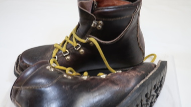
Ski Boots - Cross Country
Cross country boots are no longer attached to the ski by three holes hooked onto 3 'nails'. Very dark brown solid leather boots with 3 steel loops each side on the lower and 2 steel hooks on the upper section of the opening. The tongue is high and padded. The laces are thick and yellow. The sole is a thick rubber with 3 toe holes (to attach to skis) at the front end.Outer side: embossed 'V'. Inside tongue: 'Vasque / Boots'. Bottom of sole: 'Vibram / 'Made in Italy'cross country boots, skiing boots, falls creek, snow, cross country skiing -
 Kiewa Valley Historical Society
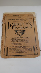
Book - Farming - Pastoral & Agricultural, Dalgety's Review 1906-1907
... the Kiewa Hydro Electric Scheme commenced in the Upper Kiewa Valley ...Dalgety's is a stock and station agent who produced a 'monthly record / of Australian Pastoral / and Agricultural Affairs / with Commercial news / and General information.' 1906 was the 14th year of publication.The Kiewa Valley consisted only of farming until the late 1940s when the Kiewa Hydro Electric Scheme commenced in the Upper Kiewa Valley creating the townships of Bogong and Mt Beauty and the corresponding infrastructure. This book would have been subscribed to (9pence) by local farmers all the way along the valley.Paper cover with black print and sketch of a sheep's head with horns in the centre. It has 140 pages which include black & white print of articles, advertisements, charts and photos.dalgety's review 1906, kiewa valley farmers, stock and station agent -
 Kiewa Valley Historical Society
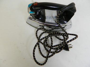
Iron - Electric
From c1950s electrical irons were used. The thermostatic iron followed the electric iron used with a container that enabled water to be sprayed onto the cloth. Damp cloth was more easily pressed. This thermostatic electric iron was one of the early models.This iron was used by residents of the Kiewa Valley including those living at Mt Beauty where there was electricity and an SEC shop from c1950.This is a "General Electric" iron. It has a steel base with a chrome upper and black plastic handle. It is thermostatically controlled with water spray. The electric cord is permanently attached, at right angels, to the handle base. A red button activates the water spray when pushed. A white button slides to enable fabric selection. A metal hole in the front of the handle is used to fill the iron with water.General Electric; Wash and Wear / Wool / Cot / Lin; Australian General Electric Appliances Pty Ltd.; Notting Hill Victoria. 1100 Wats 240 Volts AC only. V/A2F Cat. No. 10 FS10iron;, electrical appliance, laundry, domestic, pressing clothes -
 Kiewa Valley Historical Society
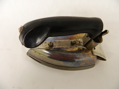
Iron - Electric
This iron was used when electricity became available. It was possibly used for smaller items that didn't require a lot of time. Residents of the Kiewa Valley used irons for pressing the family's clothes and linen - usually by the women as it was considered to be part of their domestic duties.A small electric iron, for heating only. "Hot Point" brand with a steel body and a black plastic (or could be Bakelite) upper body that is chromed. The electric cord is detachable and not with the iron.Hotpoint Cat No. 6266 G7 Watts 575 - Volts 240. Ps 7 Made in Australiairon, laundry, domestic, pressing clothes, household, electric -
 Kiewa Valley Historical Society
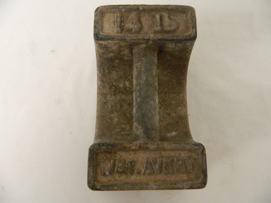
Weights
Weight was used on platform type scale to weigh farm produceImperial weights were used prior to 1966 when decimal currency was introduced. Weights were used in stores selling farm produce prior to packaging.Cast iron weight with a solid base the upper side curved to form two ends which are joined by a cylindrical handle. The ends are embossed on the top.W & T Avery 14 lbweights. scale. farms produce. w & t avery. -
 Kiewa Valley Historical Society
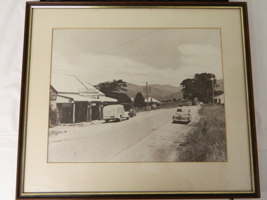
Photo - Tawonga Store
... in the 1950s when the population of the area in the Upper Kiewa Valley ...This photo was taken in the 1950's when Pearce Bros. owned the Tawonga Store. I.R.Northey's van is parked outside the store. Kodak photos are advertised. The Bakery existed. The road is sealed and telephone and electric wires are shown. The Pearce Bros owned the Tawonga Store in the 1950s when the population of the area in the Upper Kiewa Valley and High Plains was high due to the construction of the Kiewa Hydro Electric Scheme by the State Electricity Commission of Victoria.Sepia photo of Pearce Bros. Tawonga Store including a house next door, cars in the sealed street and part of the Bakery opposite. It has a slim wooden frame & white cardboard border. It has a clear glass cover. The back is lined with brown paper with a white cord across for hanging the photo.tawonga store. pearce bros. tawonga bakery. i.r.northey. -
 Kiewa Valley Historical Society
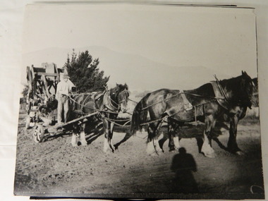
Photos - Horse team working on farm x3
Horses were coupled together to form a team to pull farm machinery to work on farms. Later, petrol and kerosene equipment was used and then diesel. The Kiewa Valley consisted of farming families before the Kiewa Hydro Electric Scheme was constructed in the late 1940's at the upper end of the valley. Three large black & white photos of a horse team pulling farm equipment. 1. Mouldboard plough 2. header 3. thresher or chaff cutter. 1.& 2. are working on the farm 3. is pulling the machinery to a nearby farm. No labelsfarm equipment. horse teams. farming. crops. -
 Kiewa Valley Historical Society
Folder - Samuel Keith Pearce, Samuel Keith Pearce
... the context of the history of the Upper Kiewa Valley. Samuel Keith ...Keith Pearce was a well known identity in the Kiewa Valley as a councillor on the Bright Shire and the owner of stores in Tawonga and Mount Beauty. He was a main instigator of the development of the area after the S.E.C.V. completed the Kiewa Hydro Electric Scheme. S.K. Pearce was a significant identity in the Kiewa Valley having achieved much during his lifetime and within the context of the history of the Upper Kiewa Valley. Red plastic with clear front cover with 8 sleeves / pages. Includes publications about the life of S.K. Pearce 1917 - 1994samuel keith pearce. bright shire; supermarkets; mt beauty; tawonga -
 Kiewa Valley Historical Society
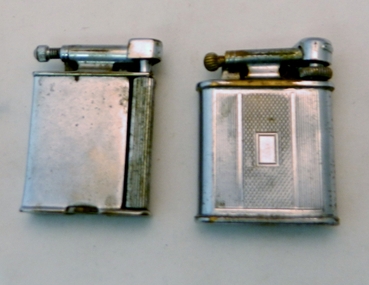
Lighter Lift Arm, Circa 1930's to 1940's
This cigarette or pipe lighter was in use in the mid 1900's when the majority of users were men. Ladies did smoke but mainly not in "public" The activity was still regarded as a male activity. Middle to Upper "Class" of women nearly always had a gentleman "at hand" that would "light up" her cigarette. This was seen as a "social" activity only but later in the mid 1900's onward it was quite acceptable for both sexes to "smoke" at anytime.This type of lighter was male orientated due to the degree of lighting the flint with the horizontal movement required a strong thumb action across the lighting wheel. It is significant to rural areas such as the Kiewa Valley as the majority of men (especially during and after World War II) regarded smoking as a way to ease off the "tension" of hard work. The socio-economics of the Australian work place changed after the emancipation of women in the "workforce" after the World War II depleted the male workforce for the duration of the War and changed the Australian ethics of women in all aspects of both city and rural working "so called" male only occupations.This Polo Swift lift arm cigarette/pipe lighter has a chrome plated shell and is fueled by petrol. To operate this lighter you lift the "snuffer" arm exposing the wick, then scrape the flint wheel to create a spark from the adjacent flint(resting on the brass ignition wheel).At the bottom of the lift arm station "POLO". Each side of the lighter are "Art Deco line running from the top of the lighter to the bottom. Between these is a rectangular box with "diamond crossed lines"early hand lighters, smoking in the 1930's, cigarette lighter, tobacco, cigerettes, lighter -
 Kiewa Valley Historical Society
Lighter Lift Arm, circa early 1900s
This cigarette or pipe lighter was in use in the mid 1900's when the majority of users were men. Ladies did smoke but mainly not in "public" The activity was still regarded as a male activity. Middle to Upper "Class" of women nearly always had a gentleman "at hand" that would "light up" her cigarette. This was seen as a "social" activity only but later in the mid 1900's onward it was quite acceptable for both sexes to "smoke" at anytime.This type of lighter was male orientated due to the degree of lighting the flint with the horizontal movement required a strong thumb action across the lighting wheel. It is significant to rural areas such as the Kiewa Valley as the majority of men (especially during and after World War II) regarded smoking as a way to ease off the "tension" of hard work. The socio-economics of the Australian work place changed after the emancipation of women in the "workforce" after the World War II depleted the male workforce for the duration of the War and changed the Australian ethics of women in all aspects of both city and rural working "so called" male only occupations.This Roller Beacon lift arm cigarette/pipe lighter has a chrome plated brass shell and is fueled by petrol. To operate this lighter you lift the "snuffer" arm(long roller lift arm) exposing the horizontal external flint tube, then scrape the flint wheel to create a spark (to light the wick) from the adjacent flint(resting on the brass ignition wheel).At the base to the left of the "filler" screw "PATENT No. 485037, 818155" underneath "REG. DES. N" on the filler screw "ROLLER REG" underneath "TRADE MARK". To the right of the "filler", "THE ROLLER BEACON MADE IN ENGLAND"early hand lighters, smoking in the 1930's, cigarette lighter, cigarette, tobacco -
 Kiewa Valley Historical Society
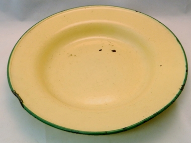
Plate Enamel, mid 1900's
... for overnight workers and campers in the upper Kiewa Valley and its high ...This "outdoor" dinner plate was made in Hong Kong and is therefore dated well after World War II. It was imported from Hong Kong at the beginning of the start of the great Asian influx of cheap household/camping kitchen and dinner plates(1960's onward). It is also during the time before stronger and more resilient plastic "camper" goods. It was at the start of the city based outdoor campers Australian bush adventure holidays.This plate is very significant to the High Plains cattlemen of the Victorian Alpine Region. Because of its unbreakable and easy to clean qualities this type of plate and associate mugs where a necessity for overnight workers and campers in the upper Kiewa Valley and its high plains regions. The Kiewa Valley has small township centres and to survive in the Australian bush high country environment camp-side fires and meals required sturdy utensils and plates.This yellow enameled tin soup/salad/dinner plate has a green boarded rim and can hold a variety of different meals. This plate is sturdy enough for any outdoor activity and was used by campers and cattlemen.Stamped on the bottom base " made in Hong Kong 24 cm E MELLING CO LTD"enamel outdoor plates and mugs, camping kitchen utensils -
 Kiewa Valley Historical Society
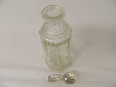
Decanter Glass, circa mid to late 1900's
This "art deco" style of containers were very popular by the "art and trendy" socialites, be they in the city or in rural towns and properties. This style was very popular in the 1940's to 1950's. The octagonal shape provided the stability of the decanter with its "expensive" contents. Because of its style it blended in well with any lavish meal and socio economic "upper" class environment. It was a part of social atmosphere of elegance and wealth be it in the city or on a rural property. This is very significant to the Kiewa Valley rural "society" environment. At the time of its use the wealth of Australia was "riding on the sheep's back", that is rural income(primary producers), on the whole, was well above that in the cities (industrial). It was in a period where large wealthy property owners could spend lavishly on trendy domestic items.This octagonal glass decanter with its egg shaped stopper is made in an "art deco" style and reflects the 1950's style of bold design. The decanter "stopper" has been cut in a "diamond" cut to reflect the sunlight as does a diamond ring. The stopper is tapered down to permit easy placement and removal. The Stability of the decanter is increased by the broad base and octagonal (8) sides tapering going up the sides.decanter, glass, art deco glass ware, spirits container -
 Kiewa Valley Historical Society
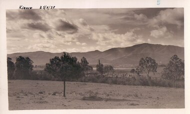
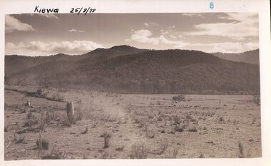
Black and white photograph of farmland, Kiewa, 25/8/38, circa 1938
... Scheme This photograph is important as it shows the upper Kiewa ...This photograph was taken in August, 1938 some eight years prior to the establishment of Mt. Beauty as a township. The area was still being used for grazing, and the land was eventually acquired from the local land owners by the State Electricity Commission. The construction of the road, from Tawonga to the High Plains, was commenced in April of this year. This allowed men and heavy equipment to be transported to the work sites for the construction of the Kiewa Hydro Electric Scheme This photograph is important as it shows the upper Kiewa Valley as it was before the establishment of the town of Mt. Beauty. The land has been cleared of natural growth and has been used for grazing cattle. By 1946 housing construction had commenced for the new town of Mt. Beauty and by 1948 street construction in the southern part of the town was completed as far as Hill Street.A black and white photograph of farmland with Mt. Emu in the background. This has been taken from where Mt. Beauty township now stands prior to road making and the erection of houses. A line of trees below the hill line indicates the position of the East Kiewa River. (No. 5 in a set of 8) Handwritten in black ink on the upper left corner of the photograph is the inscription 'Kiewa 25/8/38' and the number 5 has been stamped on the upper right hand corner. On the back is the word 'Velox' which is the name of the photographic paper on which the photo was developed.road construction, kiewa, tawonga, mt. beauty, secv -
 Kiewa Valley Historical Society
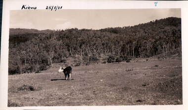
Black and white photograph of farmland, Kiewa, 25/8/38, circa 1938
... as it shows the upper Kiewa Valley as it was before the establishment ...This photograph was taken in August, 1938, some eight years prior to the establishment of Mt. Beauty a a township. The area was still being used for grazing, and the land was eventually acquired from the local land owners by the State Electricity Commission. The construction of the road, from Tawonga to the High Plains, was commenced in April, 1938 and this photograph was taken August, 1938. This allowed men and heavy equipment to be transported to the work sites for the construction of the Kiewa Hydro Electric Scheme. Prior to this access was by bridle trail, either on horse back or on foot. By 1946 housing construction had commenced for the new town of Mt. Beauty and by 1948 street construction in the southern part of the town was completed as far as Hill Street.This photograph is important as it shows the upper Kiewa Valley as it was before the establishment of the town of Mt. Beauty. The land has been cleared of natural vegetation to allow grazing of cattle. Black and white photograph of grazing farmland with one animal standing in the paddock. The area could possibly be where the golf course now stands with the road to the high plains not yet commenced.Handwritten in the upper left hand corner 'Kiewa 25/8/38'. The number 7 has been stamped in the upper right hand corner. It is part of a set of 8 photographs. On the back are the words Velox repeated several times, indicating the type of photographic papergrazing, kiewa, mt. beauty, secv -
 Kiewa Valley Historical Society
Photograph Farm Land, Kiewa, 25/8/38, circa 1938
... the upper Kiewa Valley and the site for Mt. Beauty as it was before ...This photograph was taken in august, 1938 some eight years prior to the establishment of Mt. Beauty as a township. The area was still being used for grazing cattle and the land was eventually acquired from the local land owners by the State Electricity Commission. The construction of the road, from Tawonga to the High Plains, was commenced in April of 1938. This allowed men and heavy equipment to be transported to the work sites for the construction of the Kiewa Hydro Electric Scheme. Prior to this access was by bridle trail, either on horse back or by foot. By 1946 housing construction had commenced for the new town of Mt. Beauty and by 1948 street construction in the southern part of the town was completed as far as Hill Street.This is an important photograph as it shows the upper Kiewa Valley and the site for Mt. Beauty as it was before the establishment of the town. The land has been cleared of natural vegetation and used for grazing cattle.Black and white photograph of farmland, cattle in the distance, hills in the backgroundHandwritten in the upper left hand corner, in black ink, 'Kiewa 25/8/38'. The number 8 has been stamped in the upper right hand side of the photograph. On the back have been stamped the words Velox, indicating the type of photographic paper.kiewa, mt. beauty, construction, grazing, secv -
 Kiewa Valley Historical Society
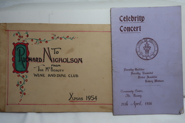
Cards - Owned by Nesta Drew, 1. The Mt Beauty Wine and Dine Club and 2. The Lodge of Beauty Programme
... activities partaken during the 1950s in the Upper Kiewa Valley during ...The Mt Beauty Wine and Dine club existed during the construction of the Kiewa Hydro Electric Scheme as part of the social life. These cards were owned by Nesta Drew nee Cooper. The Celebrity Concert dated 20th April 1956 was held at the Community Centre Mt Beauty during the construction of the KHES.A good example of social activities partaken during the 1950s in the Upper Kiewa Valley during the construction of the KHES. Nesta Drew lived on a farm in the Kiewa Valley.1. Buff coloured cardboard hand-made Christmas card sent to Richard Nicholson from the Mt Beauty Wine and Dine Club. Xmas 1954. and 2. Pale purple cardboard cover with cream paper centre. It includes sponsors advertisements and has the programme in the centre. Celebrity Concert run by the Lodge of Beauty Masonic Lodge No. 658.nesta drew, beauty maonic lodge, mt beauty wine and dine club -
 Kiewa Valley Historical Society
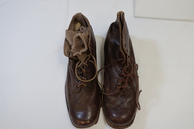
Riding Boots - Army
Leather riding boots were worn by the cavalry for their protection and endurance. Gaiters were also added to increase the protection and comfort. See KVHS 0267, KVHS 1365, KVHS 1367 Men from the Kiewa Valley joined the army and some were in the cavalry. See KVHS 0267, KVHS 1365; 1367Brown leather boots with sewn-on thick sole. Covered ankle with 8 eyelets for thin brown laces. This leather piece is sewn onto the upper front leather piece. It has a cotton piece at the heel to enable the wearer to pull the boot onto the foot. It has a soft leather tongue. Note: an army sock is enclosed in one of the boots.military, army, horse riding, riding boots, cavalary -
 Kiewa Valley Historical Society
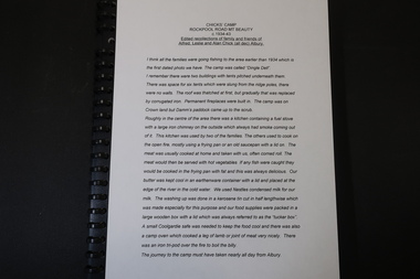
Booklet - Chicks' Camp Rockpool Road Mt Beauty
... in the Upper Kiewa Valley prior to the KHES being constructed.The ...The Chick family went fishing and lived on Rockpool Road beside the East Kiewa river from c1934-43. This was before the construction of the Kiewa Hydro Electric Scheme. The Chick family camped in the Upper Kiewa Valley prior to the KHES being constructed.The memories and photographs are important for their contribution to this time.Black folder bound with plastic spiral ring. Page 1. includes a letter from Jan Hunter (nee Chick) to KVHS. Pages 2 -4 Written history. Page 5 An index to the 7 photosOn letter: 'Barbara - had this ready before I spoke to you. Jan'chick family, rockpool road, early camping -
 Kiewa Valley Historical Society
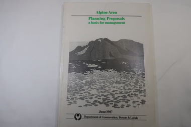
Book - Book - Alpine Area - Department of Conservation, Forests & Lands, Alpine Area / Planning Proposals / a basis for management. 1987
... of the Kiewa Valley and the planning for it is of interest to the Kiewa ...It is the policy of the Government that most of the State's alpine area will be proclaimed as an Alpine National Park, which would complement the Kosciusko National Park in N.S.W.. This is yet to be achieved (1987), however there is a need for sound, efficient and coordinated management based on the area's natural features, values and uses. Planning is proceeding on this basis.Victoria's alpine area is one of the State's most outstanding and spectacular natural areas. It is noted for its diverse plant and animal life, scenery, recreation opportunities and as a water catchment. This country is at the upper end of the Kiewa Valley and the planning for it is of interest to the Kiewa Valley inhabitants.White bound book with green print for title at the top, black & white picture and black print at the bottom for the name of the government authority publishing the book.143 pages with fold out map after page 7. The map is coloured green to indicate the planning area.alpine area, bogong national park, victorian department of conservation forests & lands -
 Kiewa Valley Historical Society
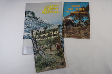
Books x3 - Walking on the Bogong High Plains, 1. The Alpine Track Walhalla to Mt Bogong. 2. Bogong High Plains and Adjacent Peaks both by John Siseman 3. Alpine Safety Manual
... Plains and Mt Bogong are at the upper end of the Kiewa Valley ...Books were published to guide walkers travelling long distances in remote areas increasing their safety and giving them independence.Bogong High Plains and Mt Bogong are at the upper end of the Kiewa Valley where local people and visitors spend their leisure time, walking.1. and 2. both written by John Siseman, small (pocket size), includes maps and black & white photos. The covers are colored photos with the title at the top. 1. has 78 pages and 2. has 63 pages.The Alpine Safety Manual (in yellow) is twice the size of the others and published by the Department of State Development, Decentralization and Tourism.It has 40 pages, coloured and black & white photos and is held by 2 staples.bush walking, bogong high plais, walhalla to mt bogong, alpine track -
 Kiewa Valley Historical Society
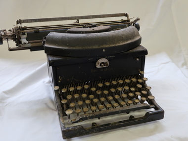
Typewriter - Remington
The first typewriters were placed on the market in 1874.It includes both upper and lower case letters via a 'shift' key and has a QUERTY layout.Used by typists working in the office for the State Electricity Commission of Victoria during the construction of the Kiewa Hydro Electric Scheme.Large heavy typewriter. Rusty condition 1926 ? Metal frame with black paint"Remington" on the front above the keyys "Chartre? Business Service" suppliertypewriter, remington, office equipment -
 Kiewa Valley Historical Society
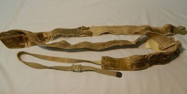
Seal Skins Ski Straps / Soles, mid 1900's
... sections of the upper Kiewa Valley and the Alpine regions were ...These seal skin straps and webbing were introduced into the Victorian Alps by European engineers, conducting survey work for the SEC Hydro scheme in the late 1930s. This period in time produced many immigrants from a war torn Europe with highly developed technical skills. Many of these immigrants provided articles that were well suited to the alpine regions of Australia, ones they used in their homelands. These were times when the home grown cultures of the Anglo Saxon heritage of the earlier settlers within the Kiewa Valley became interwoven with the various European cultures and this formed, what in later years became the beginning of the Australian multi-cultural society. The Kiewa Valley and its surrounding regions where the major rural areas which did not progress in a so typical Aussie "dinky-di", "she'll be right" fashion. The European influence was however not too strong, so as to obliterate the flavour of the home grown rural society.The major populated sections of the upper Kiewa Valley and the Alpine regions were accelerated by the SEC Hydro Development which brought into the slow growing rural regions a quasi multi ethnic society, however this was only noticeable up to the time when the final Power Station was commissioned in the 1960s. The slight variations to the typical Australian rural settlements of the time were in some food preparations, winter apparel such as these seal skin straps and soles and "langlauf" (cross-country skis). The sealskins were sewn so that their grain ran from front to back thereby allowing the skins to grip going up hill and glide going downhill.The gardens and varieties of flowering shrubs and trees where also more in line with traditional European "outdoor" settings. Seal skin sewn onto one side of a strap of webbing. There is a webbing loop on the front that slips over a small point at the front of the ski. There is a webbing strap attached to the back of the seal skin sole coming over the back of ski that clips metal fasteners onto a loop of webbing behind the ski boot. alpine sports, snow skis, winter clothing, mount bogong recreational activities, snow sports -
 Kiewa Valley Historical Society
Fan Personal, circa 1920's
Personal fan of Asian origin used by early immigrant family living in Kiewa Valley and indicative of the mixed heritages within the Valley. Personal Fan of vintage circa 1920s suggests middle to upper socio-economic levelHistorically this item places certain ethnic group in the Kiewa Valley circa 1920's - 1950's. This personal fan indicates that it may have belonged to a middle class person with greater leisure time than that of a working class. The multicultural fabric of the region is also highlighted.Personal hand fan (slide out sideways open). Cardboard screen on wooden spine frame. Main side bright coloured green trees on golden red and royal blue background. Wispy silver lined clouds, black branches and brown earth with moss. Flip side gold speckled on white background Bamboo like sliversfan, personal fan, cooling, oriental, hand fan -
 Kiewa Valley Historical Society
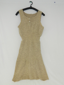
Dress Knitted
This dress was possibly manufactured by a local seamstress in the period circa early 1900.The quality of the dress suggests that the lady who wore it was from middle to upper range of the socio-economic structure within the Kiewa ValleyHistorically this item dating in the early 1900s was made by a very competent seamstress (lack of manufacturer's label). It demonstrates that the conditions of relative isolation within the Kiewa Valley was not extreme and that local manufacture of clothing items were available and at a very high level of quality. This item demonstrates that the hand made era was alive and an essential part of community/social adhesion within the valley.Beige knitted dress, sleeveless ladies pin weaved running from waist to bottom. Fine pin weave from bust to waist. Two mother of pearl buttons fastening opening front neck 11cm from neck to upper breastno manufacturer's label suggesting manufacturer was a very talented local seamstress costume, woollen, knitted, dress, female clothing -
 Kiewa Valley Historical Society
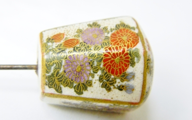
Hat Pin
Historically this item could be a valuable antique worn originally by a wealthy upper class woman. The fine hand painted pictures with gold boarders and porcelain body suggests the item was bought either in Europe or Britain and brought into Australia in the late 19 th to early 20 th century by a wealthy landed gentryThis item is a reflection of both the fashion mode of the 1800s to mid 1900s when long hair needed to be controlled by hair pins rather than later manufactured hair sprays. It is also an example of society's mores of tidiness and quasi religious beliefs of covering the hair and head when outdoorsHead of pin is six sided, domed top made of porcelain. Two sides have hand painted pictures of grapes, two sides with flower arrangement , two sides detailing cypress tree tips of branch, top has flowers and leaves with hidden small birdshat pin, porcelain hat accessory, millinery clothing -
 Kiewa Valley Historical Society
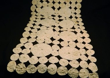
Table Runner, circa 1920s to 1950s
Historically this item highlights the middle to upper to middle socio economic levels of a rural community in the 1920s to 1950s. The fashion dictated to by the larger cities and towns were for some smaller items of house hold furniture encompassed by homes in the region, not only because of practicality but also for longevity of the item it protected.The significance of this item in showing that although the region was to a small degree isolated from the "latest" fashion of house hold dressage, it was to a certain degree not regional and that the fashion of the day in large cities and towns was instilled through magazines and Country Women,s organisations.Fine cotton table runner. Middle section has a 2cm wide crochet insert around it with another border of cotton around it 2cm wide. All the item is edged with a 7cm wide crochet band.hand craft, furniture dressing, lace, crochet, cotton furniture proctective coverings