Showing 10586 items matching "historical records"
-
 Kiewa Valley Historical Society
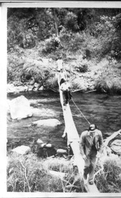
3 small black and white photos of West Kiewa River and Tail Race, c1948/49
... on 22d July. Historical record of the construction of the Kiewa ...The No. 4 Tail Race Tunnel was commenced in 1947 from the downstream end at Mt. Beauty. Difficulties were encountered and driving from the top end in a downstream direction was commenced in January 1950 and the breakthrough between these two headings occurred on 22d July.Historical record of the construction of the Kiewa Hydro Electric Scheme.3 small black and white photographsPhoto 1 - on back in ink - 'Tour of area, crossing West Kiewa Branch Jan. 1949 Photo 2 - on back in ink - 'Kiewa Valley River - site of tunnel in rear. Dec. 1948'. Photo 3 - on back in ink - 'No. 4 Tail Race Portal Mt. Beauty Jan. 1949'.west kiewa river; tail race portal; mt beauty; kiewa hydro electric scheme -
 Kiewa Valley Historical Society
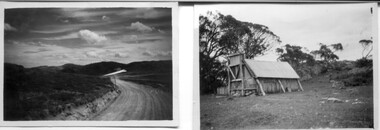
18 small black and white photographs of the Bogong High Plains, 1948
These photos of the Bogong High Plains were all taken by Ronald George Thorn who was a cadet engineer with the State Electricity Commission. He worked on the Kiewa scheme from 1948 to 1950 doing overhead line construction and maintenance plus electrical design and drawing work. They are from his personal collection and a record of his time in the Kiewa area.Pictorial history of personal involvement in the the early days of the Kiewa Scheme.18 small black and white photographs all taken on the Bogong High Plains.Photo 1 Wallace's Hut. Photo 2 Ruined Castle - Looking towards Pretty Valley December 1948. Photo 3 Ruined Castle - Looking towards Pretty Valley December 1948. Photo 4 Ruined Castle - Looking Down Valley December 1948. Photo 5 - Mt. McKay from Ruined Castle October 1948. Photo 6 View from Rocky Valley Camp October 1948. Photo 7 Mt. Feather Top from Ruined Castle October 1948. Photo 8 View from Ruined Castle looking downwards towards Beauty October 1948. Photo 9 Rocky River from gauging station October 1948. Photo 10 Rocky Valley River from main road October 1948. Photo 11 View along little Arthur Fire Track October 1948. Photo 12 View along main road. Looking towards Beauty Valley October 1948. Photo 13 View from Little Arthur Fire Track October 1948. Photo 14 Frying Pan Spur from Rocky Valley Road October 1948. Photo 15 Mt. Bogong from Big Hill Fire Track October 1948. Photo 16 View from Big Hill Fire Track October 1948. Photo 17 Mt. Feathertop from Ruined Castle October 1948. Photo 18 Mt. Fainter from Ruined Castle October 1948. (All of the above is hand written on the back of photos in ink). bogong high plains; r g thorn; secv; kiewa hydro electric scheme; pictorial history -
 Kiewa Valley Historical Society
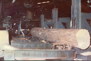
Photographs - 2 Colour photographs of logs being harvested and milled for timber in the Kiewa Valley
... Ltd which employed approximately 50 people. An historical ...: Hume and Hovell discovered the area in 1824 and by the end of the 19th century the Kiewa Valley was transformed by logging, dairy and beef cattle properties and tobacco farms. The logs could have been milled for timber at the State Electricity Commission's mill at Howman's Gap which provided a much needed source of timber for construction of McKay Creek Power Station which began construction in 1951 and also the camps and houses for the workers and their families There was a need for housing and infrastructure for an increasing population of workers for the hydro-electric scheme as there was a general shortage of this commodity. A timber mill was started in Tawonga by Mates, of Albury, in 1945, and electricity became available in 1946 the S.E.C. bought the mill, and enlarged it. In 1960 it was purchase by a local family, they also started a timber mill in Mt Beauty worked both until 1980 when they closed the Tawonga mill and enlarged the mill called Mt. Beauty Timbers Pty Ltd which employed approximately 50 people. An historical pictorial record of the type of machinery and vehicles in use in the 1950’s to harvest and mill the logs from surrounding forested areas.1. Colour photograph of large logs being milled for timber at a timber mill 2. Colour photograph of heavy machinery being used to harvest large logs for milling timber; timber mill; kiewa valley; forests; logging -
 Kiewa Valley Historical Society
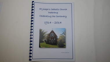
Book - Catholic Church Dederang, St Joseph's Catholic Church Dederang Celebrating the Centenary 1914 - 2014, 16th November 2014
Initially in the 1880s, services (known as stations) were held at Creamer's home in Dederang - generally x3 per year.In 1883 a small church was built where the present church now stands.This weatherboard church, St Joseph's, was replaced by a brick one in 1914 and opened on 8th Nov. 1914. The book has 9 chapters, the last one being 'Photo Gallery'. It covers the religious men, local families, newspaper snippets and records.Religion was an important part of life to people throughout the 20th century especially in a rural community as it gave people an opportunity to be part of the community and to socialize. This book gives a history of religion, of maintaining a church, of a rural community and of the Catholic religion.58 pages of printed history followed by 10 pages of colored photos in a spiral book with a blue spiral spine and a clear plastic cover. The front page includes the title in blue print with a colored photo of the church below the title.st joseph's catholic church dederang; kiewa valley; dederang families; catholic clergy; religion -
 Kiewa Valley Historical Society
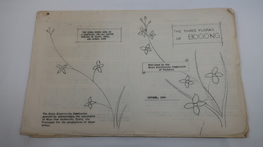
Mills Collection of Papers, 1. Unknown 2. October 1964. 3. Unknown SECV. 4. June 1963. 5. Unknown, Victorian Dept of Education. 6. Unknown SECV
Catelogue of flora and fauna of the 1960s in the Kiewa Region.A collection of papers including: 1. Three poems. 2. The ''Three Floras of Bogong'Oct 1964. 3. 'SEC Bird Life within and adjacent to the Kiewa Works area' recorded between 1963 and 1964. 4. 'General Geology of the Kiewa Area' June 1963. 5. Victorian Department of Agriculture, 'Tobacco', Notes for Students/Geology/Maize Culture/The Buffalo Dam Project/Stamped with 'Hoys Passenger Service Pty Ltd'. 6, SEC Kiewa Region, Forestry and Conservation.No. 5. - Stamped with 'Hoys Passenger Service Pty Ltd'flora, bogong, birds, geology, kiewa valley, tobacco, forestry and conservation, secv -
 Kiewa Valley Historical Society
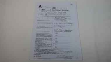
AIF Service Record of Henry John Higginson
The Higginson family farmed in the Kiewa Valley17 pages of photocopied pages from Henry John Higginson's enlistment and service history with the Australian Imperial Force (WW1)world war 1, war service, higginson, kiewa valley -
 Kiewa Valley Historical Society
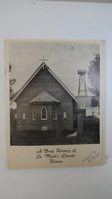
Booklet - St Mark's Church Kiewa x2, A Brief History of St Mark's Church Kiewa written by E. Temple
The Anglican Church at Kiewa. The first stone was laid on the 29th Oct. 1924. In 1879, the Yackandandah rector commenced services on Sundays in private homes in the Kiewa Valley. In 1911 Anglicans met in the Kiewa Methodist Church to elect a committee to organise financial offers and so it eventually became a vestry.The town Kiewa is in the Kiewa Valley. The church served other communities in the Valley. The book records the local populations and their commitment to religion. Cream cardboard cover with a black and white photo of the church on the front cover. It has 4 pages printed on both sides held by 2 staples. Inside there are a few black and white photos. Dated 19741. "Written by E. Temple" handwritten on the front cover 2. "C. Roper" on the front cover and inside the front cover "Clare Roper" Also, "Esther Temple" 's signature on the cover page.st mark's church, kiewa, anglican church, esther teple, thomas mitchell -
 Kiewa Valley Historical Society
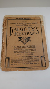
Book - Farming - Pastoral & Agricultural, Dalgety's Review 1906-1907
Dalgety's is a stock and station agent who produced a 'monthly record / of Australian Pastoral / and Agricultural Affairs / with Commercial news / and General information.' 1906 was the 14th year of publication.The Kiewa Valley consisted only of farming until the late 1940s when the Kiewa Hydro Electric Scheme commenced in the Upper Kiewa Valley creating the townships of Bogong and Mt Beauty and the corresponding infrastructure. This book would have been subscribed to (9pence) by local farmers all the way along the valley.Paper cover with black print and sketch of a sheep's head with horns in the centre. It has 140 pages which include black & white print of articles, advertisements, charts and photos.dalgety's review 1906, kiewa valley farmers, stock and station agent -
 Kiewa Valley Historical Society
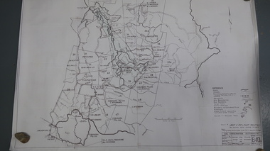
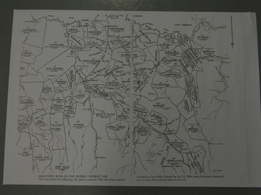
Map - Bogong High Plains - Grazing Runs, Grazing Run Boundaries 1960 - Soil Conservation Authority
Cattle grazing on the Bogong High Plains during summer commenced in the 1840s and continued for many years. The Soil Conservation Authority recorded each family's area boundaries which were updated in June 1972 and continued to be adjusted until cattle were banned in 2005. The tradition of cattle grazing continues to be controversial.Holders of grazing rights for grazing on the Bogong High Plains were allocated specific areas recorded by the Soil Conservation Authority in 1972. Cattle have been banned in the Alpine National Park due to their impact on the environment.White paper with brown print. Bogong High Plains from Feathertop in the west to Mt Nelse in the east showing physical boundaries including the Kiewa Hydro Electric Scheme, roads, rivers and mountains. Names of families with grazing runs and the boundaries are shown.cattlemen, grazing runs, bogong high plains, kiewa valley families -
 Kiewa Valley Historical Society
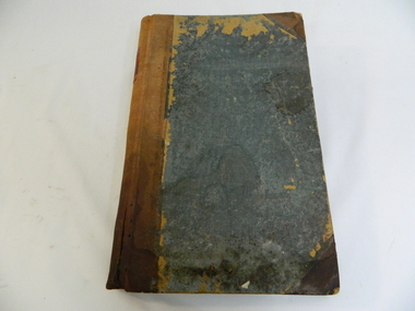
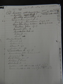
Ledger - Tawonga Store 1915 to 1920s, c1915
The Tawonga Store was a general store in the Upper Kiewa Valley providing for a farming community. This store which had a variety of items was the main store for many of the farming families who would travel on horse and cart to make weekly trips to the store for supplies. This ledger was used by the owner of Tawonga Store to keep a record of items sold and to whom. George Potter owned the Tawonga Store before 1920. Whit Potter, George's son, worked with his father for many years. Attached to this ledger is a sheaf of letters which were sent to the Potter's, which are relevant to the day to day operation of a General Store. The ledger gives a comprehensive list of what type of items the residents of the Kiewa Valley purchased during this period, thus has great historical significance. It is well provenanced and very good interpretive capacity. Green linen covered cardboard cover. Brown (leather look) paper spine. Inside cover is red and green marbled paper. It has an alphabetic index at front. 262 ledger pages, the edges of which have been marbled.Ledger - printed on a red square embossed in gold on a brown thick paper spinetawonga, general store, book-keeping, ledger, george potter, whit potter -
 Kiewa Valley Historical Society
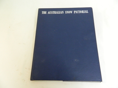
Book - Miscellaneous - Pictorial - Snow, Georgian House, The Australian Snow Pictorial, c1952
This book records the history of skiing in Victoria with photos of places and people showing equipment used in the snow fields and used by skiers.Falls Creek and the Bogong High Plains are included in this book showing photos of local people and machinery etc. Dorothy Anderson (nee Ryder) owned and used this book. She lived at Tawonga.This is a bound pictorial book with a blue cover and white printed title.. The subject is Alpine resorts and ski areas in the Australian High Country in the 40s and 50s. 'To our very dear friends, Mr and Mrs Ryder, with our best wishes for a Merry Christmas & a Happy New Year from Harold and 'Rel / Ril ?' 'snow, skiing, photography, pioneers, enthusiasts, heritage, st elmo, secv machinery, ryder family, bogong high plains, rope tow -
 Kiewa Valley Historical Society
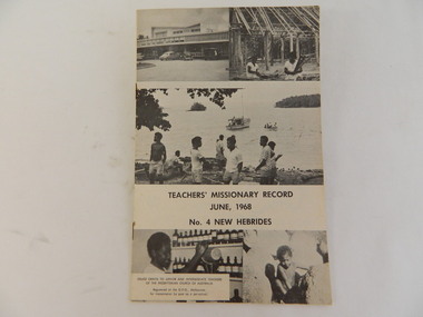
Book - Religious Education, Teachers' Missionary Record, June 1968
Students attended Sunday School classes at the Kergunyah Presbyterian Church. The Sunday school was held in a little 16 foot square wooden building which came from Rocky Valley after it was no longer needed there. Ewen Wallace's father initiated and organised the move. C2011 the building was knocked down because of white ants. The Presbyterian Church will be 125 years old in 2015.Historical: Religious Education: This book was used by students who attended the Sunday School classes at Kergunyah Presbyterian Church. Religion: Presbyterian Church at Kergunyah, in the Kiewa Valley, celebrates its 125th anniversary in 2015 after being handed over to the Uniting Church in the 1970s. Black and white cardboard cover with two small pictures top and bottom and one across centre front with title, date. and "No. 4 New Hebrides". Back cover "Psalm 23 for the Islands" in print. Picture underneath. Under picture "Goodbye" and more writing. Thin - 16 pages including coverTeachers' Missionary Record / June, 1968 / No 4 New Hebridespresbyterian church, teachers, religion, religious education., kergunyah, ewen wallace, sunday school -
 Kiewa Valley Historical Society
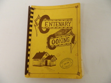
Book - Cooking x2, Centenary Cooking, 1980
The Tawonga School was a weatherboard building built on 8 acres of land catering for children from the surrounding grazing farms to ride their horses to school. It opened on 27th July 1880. The original school building and records were erased by fire in 1900. The Tawonga hall was used until 1910 when 3 acres of land was donated by Frank Cooper. It still operates today (2015) with its numbers having fluctuated over the years with the Kiewa Hydro Electric Scheme, tobacco farming and now tourism. The Tawonga community published a cook book to celebrate the school's centenary.This book may have also been used as a fund raiser.The Tawonga school celebrated its centenary with a cookbook with contributions from the community. This indicates that the school was very proud of reaching its centenary and the community co-operated with each other to develop this book.This book is a good source of the names of people who lived in Tawonga in 1980.Yellow book with brown writing and sketch of school held together with brown hard plastic binding. It has 90 pages of recipes most of which give the contributor's name.Tawonga State School Centenary 1880 - 1980 (stamped on front & back cover) In pencil on front cover: Ada Ryder An advertising for Kelvinator sticker has been stuck on the inside front cover with 18-3-92 written on it & on the inside back cover and 'Energy Rating' sticker.tawonga school. centenary of school. 1880-1980. cooking. food. kiewa valley -
 Kiewa Valley Historical Society
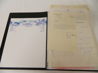
Folder - Retail Development of Mt Beauty
The papers have been collected in correspondence since 1947 and cover many of the retail shops in Mt Beauty. The sale of the shops by the State Electricity Commission during the 1960's when the construction of the Kiewa Hydro Electric Scheme was completed. Owners of the Mt Beauty Supermart and Newsagency and Falls Creek Mini-Mart, Samuel Keith Pearce and Gordon Cathew Pearce's documents are included. The papers record a period when the SECV sold the retail shops in Mt Beauty after the completion of the Kiewa Hydro Electric Scheme. This enables researchers to gauge the value of the properties at the time and the changes in retail shops from that time.A black plastic folder containing a collection of correspondence pertaining to the retail development of Mt Beauty from the 1940's through to the 1960's and 1970's. pearce bros. mt beauty. falls creek. mt beauty retail. state electricity commission of victoria. -
 Kiewa Valley Historical Society
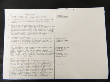
Papers - History of Mt Beauty State School No. 4644
10 points of history pertaining to the History of the Mt Beauty State School which was built in 1947 as a result of the increase in student population due to the State Electricity Commission of Victoria's construction of the Kiewa Hydro Electric Scheme. Sources sited from School records and S.E.C.V records.The papers give a detailed account of the History of the Mt Beauty State School with sources sited giving accuracy to the account.Two A3 papers with typed history of the Mt Beauty State School No. 4644 with sources sited.mt beauty. state school. state electricity commission of victoria. kiewa hydro electric scheme. -
 Kiewa Valley Historical Society
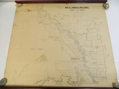
Map - Kiewa Valley, Parish Map of Mullindolingong, 12/10/1906
The map shows the names of people living in the parish of Mullindolingong in 1906. These people had leases or licences giving the reader an insight into the number of people in the area and an understanding of the size of their holdings. Infrastructure is also given including shops, schools, churches etc. Presumably it was used by the Ryder family.This map gives an historical insight into the parish of Mullindolingong as it names people and the infrastructure - roads, buildings etc. as it was in 1906. This enables the reader to compare the area at the time with other times and other places and to have an understanding of the early settlers in the area.This is a very old paper or parchment map with wooden rods top and bottom. The top rod has ribbons attached to enable hanging. The map shows the current leases and licences and when they were held by during this period, circa 1906.Mullindolingong County of Bogong. This plan has been prepared by The Most Reliable Data in the Possession of the Department up to the date of its Compilation. Information respecting Leases or Licences which await Final Completion is not recorded.parish of mullindolingong map; ryder family; early settlers; -
 Kiewa Valley Historical Society
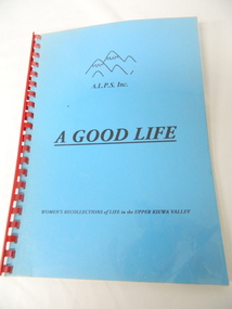
Book - A.L.P.S, A Good Life - A.L.P.S. x2, 1998
A.L.P.S. began an ongoing project to record the contribution made by women to life in the Kiewa Valley.An original history of the Kiewa Valley focusing on women from various backgrounds.A soft covered book with clear plastic cover of 81 pages with a blue cover, black written heading including A.L.P.S. Inc. logo and red plastic 'spiral' spine."Val Woinarski" & phone number inside on the first page.community group in the kiewa valley; alps -
 Kiewa Valley Historical Society
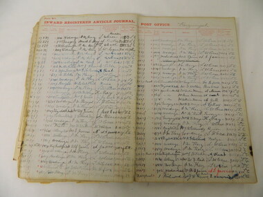
Ledger - Post Office Kergunyah, Inward Registered Article Journal Post Office - Kergunyah, 1920 - 1951
Post Offices in Victoria were required to keep track of articles posted and received with the addressee signing on receipt of the article and the name of the recipient also being recorded.Kergunyah Post Office is part of the Kiewa Valley. This register indicates the number of articles being posted during the time and the number and names of people sending and receiving articles.Register commences Nov. 1920 though to Feb. 1951. It includes the origin of the article, addressee, signature of the person to whom the article delivered, date of delivery and initials of the officer. Inside 2 loose sheets regarding tariffs for trunk line calls.post office; ledger; kiewa valley -
 Kiewa Valley Historical Society
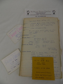
Papers of the Mt Beauty Tennis Club, 1970's onwards
The Mt Beauty tennis club was formed in the late 1940's. The number of players has varied as has the number and type of courts.Mt Beauty Tennis Club has been a part of Mt Beauty for many years involving many people. The history of the club identifies local people and the changes in the town and district regarding the popularity of tennis and tennis equipment.Paper records for the Mt Beauty Tennis Club. Minute book 1977 - 1983, 1983 - 1985, 1983 - 1990, 1991 -1999. Treasurer's book 1987 - 1996. Book tennis Competitions 1991, 1992, 1993, Rules and loose papers 1980's - 2006 and 3 types of cards Dinner Dance at the Workmen's Club, Picnic Cabaret at the Community Centre, and 1983 Tennis Club ball at Community Centremt beauty; tennis club; sport -
 Kiewa Valley Historical Society
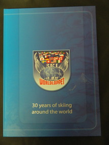
Book - Cross Country Skiing x2, Worldloppet - 30 Years of Skiing Around the World, 2007
The Worldloppet is a skiing race held throughout the world for cross country skiers. American Tony Wise conceived the idea of bringing together long distance skiers together. 14 ski marathons held in 4 continents (Europe, North America, Australia and Asia) with over 90,000 skiers each year.Falls Creek is on the Bogong High Plains at the top of the Kiewa Valley. Falls Creek held the first Kangaroo Hoppet in 1979 over a distance of 21 km with 80 participants. In 1995 a record 1588 participants took part. They received membership of the Worldloppet in 1991 holding the event on the last Saturday of August and haven't had to cancel the event. Two copies of a blue hard covered book with 167 pages consisting of an index (Kangaroo Hoppet page 54), information on 30 years of (cross country) skiing around the world with colored photos. cross country skiing; worldloppet; falls creek -
 Kiewa Valley Historical Society
Journal - John Creamer, Dairyfarmer, 1916 - 1942
Dairy farmers kept a journal to record their transactions and business on the farm. John Creamer's daughter Mary Cardwell has her father's journal covering the years 1916 to 1942.The journal was kept by local dairy farmer John Creamer who farmed at Gundowring in the Kiewa Valley. It consists of names of local people and is representative of the business (produce and life) on the dairy farm at the time.Photocopied A3 sized pages from John Creamer's dairy journal covering the years 1916-1942. The book has an alphabet index for people's names with details of their purchases (eg. mutton and potatoes) with the cost in pounds shillings and pence. Page 15 has the title "Sows When Due to Parrow" and lists the cows by name. Only pages 1 to 61 have been copied except for pages 39-41, 49, 54, 55. The rest has been digitised. See: KVHSs 1823 for digitised copydairy industry; creamer family; gundowring -
 Kiewa Valley Historical Society
Maps - Squatting Runs of the Murray District 1848 x2, July 26,1848
The Port Phillip Gazette was the second newspaper published in Melbourne, in the then Port Phillip district, now Victoria. In 1948 it was published bi-weekly.The map shows the original names of squatters along the Kiewa River. The names of the district are mostly current today although some are spelt differently.2 copies - 1 laminated & 1 paper of the map of "Squatting Runs of the Murray District 1848." The area is recorded (eg. Tawanga, Dederang, Gundowring, Kergunia, Merrimarenbung all along the Kiewa River) under which the names of the squatter is recorded, the number of acres and the licence number. Scale is 8 miles to the inch.squatting runs; kiewa valley; port phillip district; -
 Kiewa Valley Historical Society
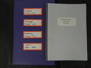
Paper Collection of Football Clubs of the Upper Kiewa Valley, 1940s onwards
Tawonga's first recorded game was against Yackandandah in 1893 at Tawonga. Tawonga folded up in 1957 enabling Bogong to have 2 teams, the firsts and seconds in 1958. Bogong merged with Dederang in 1976 and became the Dederang-Mt Beauty Football Club. Bogong joined the Yackandandah league in 1947. In 1954 Bogong entered the Ovens & King League. In 1960 Bogong United was in the Tallangatta League with Tallangatta, Kiewa, Kergunyah, Dederang, Lavington, Bandiana, Bullioh, Mitta United, Barnawartha, Sandy Creek and Yackandandah. The Kiewa league was formed in 1923. In the 1930's Tawonga was in the Chiltern League then the Dederang League, then the Yackandandah League and then the Tallangatta League.The papers are a primary source of the history of the Bogong, Tawonga, Dederang and Mt Beauty Football Clubs. They include family names of players and families living in the Kiewa Valley at the time and increase an understanding of the social changes country areas have undergone during the period covered.Paper records for local (Upper Kiewa Valley) football clubs' history including minute books, notes, journals, newspaper cuttings, footy records and booklet produced for the Dederang-Mt Beauty Golden Jubilee in 1998.football clubs; upper kiewa valley; sport -
 Christ Church Anglican Parish of Warrnambool
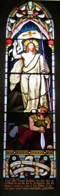
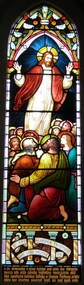
Memorial window: Eliza RUTLEDGE
Eliza Rutledge (1820-1888) was the daughter of Rupert and Jane (nee Newby) Kirk. She married William Rutledge in St James’ Church, Sydney on 18th August, 1840. She and William had five children two sons and five daughters. Recorded accounts tell that Eliza was “beloved for her kindness and hospitality” and that she and William kept open house for all manner of social events and occasions. Eliza died at Farnham Park, Dennington, on 31st August 1888. The marriage of Eliza to William Rutledge, a man of historical importance in the development of Port Fairy, Warrnambool and the western district of Victoria, places her as a person of importance.Her daughter Susan Fleetwood is also memorialised in a window in Christ Church, Warrnambool.Her son, Thomas Forster is memorialised in a tablet near the two windows for Eliza.Stained-glass lancet window, south wall, main nave. A depiction of the risen Jesus.In fond memory of ELIZA RUTLEDGE who was born on / 12th February AD 1820, who died on 31st August AD 1888, this / window is erected as a token of filial affection by her / loving children Thomas F Rutledge, Martha Hamilton and Edith McKellar.rutledge, christ church warrnambool, eliza rutledge, eliza kirk, farnham park -
 Christ Church Anglican Parish of Warrnambool
Memorial window: Elizae (Eliza) RUTLEDGE, "By Thy Glorious Ascension Good Lord Deliver Us"
Eliza Rutledge (1820-1888) was the daughter of Rupert and Jane (nee Newby) Kirk. She married William Rutledge in St James’ Church, Sydney on 18th August, 1840. She and William had five children, two sons and five daughters. Recorded accounts tell that Eliza was “beloved for her kindness and hospitality” and that she and William kept open house for all manner of social events and occasions. Eliza died at Farnham Park, Dennington, on 31st August 1888. She is buried at Tower Hill Cemetery. The marriage of Eliza to William Rutledge, a man of historical importance in the development of Port Fairy, Warrnambool and the western district of Victoria, places her as a person of importance.Their daughter Susan Fleetwood is also memorialised in a window in Christ Church, Warrnambool. Their son Thomas Forster is also memorialised with a tablet positioned near the Eliza Rutledge windows. Stained glass, lancet window, south wall, main nave. Depiction of the ascension of Christ."By Thy Glorious Ascension Good Lord Deliver Us" In Latin: +In Memoriam+ Elizae Rutledge quae pridie idus Februarias/ MDCCXX nata pridie kalendas Septembres MDCCCXXXVIII obit/ liberi amantissimi Gulielmus Rutledge et Susanna Fleetwood pietatis/ indicio hane Jenestram posuerant Beati qui sunt mundi corde.rutledge, christ church warrnambool, eliza rutledge, eliza kirk, farnham park -
 Warrnambool and District Historical Society Inc.
Book, Picturesque Warrnambool, C1891
This book presents a pictorial and written record of Warrnambool in 1891.It covers a wide range of topics. It provides statistical evidence relating to public buildings and organisations of that era, as well as basic information about district points of interest. The Mechanics Institute, the Common, Albert Park, the rivers, the Museum and the Sea Baths are all mentioned. The various drawings and advertisements provide a list of businesses which were prevalent at the time.As this book is one of only two complete copies documented to be still in existence, it is of considerable significance and importance to our collection. The drawings and text are artistically very much of the era and are aesthetically pleasing.Plain grey card cover with fabric binding. Handwriting on front cover and inside front cover. It contains a number of black and white and coloured plates depicting scenes of Warrnambool and the district. Approximately 70 pages.Old Warrnambool about 1891 hand written on label on front cover, underneath is also written “When I have finished with these please forward to Warrnambool Historical Society Warrnambool. D 77, 252 in bottom RHC of cover. picturesque warrnambool,, warrnambool 1891, -
 Warrnambool and District Historical Society Inc.
Document, Map: Lady Bay 1853, 1853
This is one of the earliest surveys and maps of Warrnambool harbor, Lady Bay. Being done in 1853, it shows the depths of the bay area marked in fathoms, currents and directions and areas of rocks around mouth of the Merri and the Western side of the bay as well as a large sand spit to the middle right of the beach region.. It also marks the large areas of seaweed and fuci in the outer bay area. It has the area of Pertobe Lagoon marked and shows the early tracks to the town. The engraving work was done by Tulloch and Brown, with Tulloch being one of the earliest engravers and lithographers in the state of Victoria. He arrived in Melbourne in 1849 and set up business with James Davie Brown in 1853 with Brown being a map engraver. They were awarded bronze and silver medals for their work at the Victorian Industrial Exhibition. He also worked in the vignettes on the Proeschel Map of Victoria.This map is of high historical and comparitive significance as it shows the Lady Bay area prior to the changes that have occurred in the last 160 years with the building of the breakwater. The issue regarding access to Lady Bay remains a current one. The engraver D Tulloch engraved some of the earliest scenes of the goldfields in Ballarat and as such has left a record of a very early and important era in Australian history. Rectangular cream paper with black text. Map area is outlined by fine black lined border. Key in top right hand corner and scale at bottom middle of map.Map is labelled Town of Warrnambool printed at top of map. Small logo at top right corner which has “Hydrographic Department” in circle around an anchor. Lady Bay Warrnambool Surveyed by John Barrow assistant surveyor Engraved by Tulloch & Brown in bottom right corner. Melbourne engraved by order of the legislative Council of Victoria in middle bottom.map, warrnambool, town of warrnambool map 1853, tulloch & brown map 1853, lady bay warrnambool,, warrnambool harbour, warrnambool breakwater, warrnambool beach -
 Warrnambool and District Historical Society Inc.
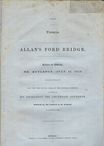
Document, Allan’s Ford Bridge 1852, 1852
This is an original Victorian Government document containing the printed version of 37 reports and letters regarding the building of the first Allansford bridge completed early in 1852. The correspondence dates from October 1850 to February 1852 and includes letters and reports from Melbourne Government employees such as Robert Hoddle, Chief Surveyor, David Lennox, Superintendent of Bridges and Lieutenant – Governor Charles La Trobe. The correspondence from local settlers included the names of William and John Allan, John Davidson and James Coulstock. The correspondence shows that some settlers in the Warrnambool/Port Fairy district wanted a portion of the Government allocated funds spent on the local roads and bridges in other locations. The 1852 Allansford bridge cost £480 and was replaced in 1870. This document has strong historical significance as it relates to one of the earliest State government works in the district and records the public imput into the decision.. It contains opinions and correspondence between a number of early settlers in the district at the time.Grey/blue paper document with black text. 21 pages plus 4 page index at back.allan's ford 1852, allansford bridge, allansford, history of allansford, warrnambool -
 Warrnambool and District Historical Society Inc.
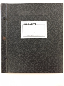
Photo, Negatives Pioneers of Warrnambool & District board, 1975
The following extract written by Karen Tyers Warrnambool Family history group explains the journey and background of the Warrnambool Pioneer Board. Warrnambool is fortunate to have a photographic record of some of its pioneers. They are commemorated on the Pioneers’ Board. The Pioneers’ Board with its elaborate frame measures approximately 2 metres by 3 metres and holds 204 photographs of Warrnambool’s early pioneers. In 1907 Edward Vidler, secretary of the Warrnambool & District Progress League and Chamber of Commerce and Industry, invited descendants of those who arrived in Warrnambool before 1860 to send photographs of their pioneer ancestors to commemorate the Diamond Jubilee of Warrnambool’s foundation in 1847. A charge of £1 for each photograph was set. Lillian Foyle of Foyle’s photographic studio, was engaged to colour the photographs and undertake the associated artwork. By December 1907 the honour board was on exhibition in Bernard’s Gallery, Melbourne. Unfortunately Vidler left Warrnambool in 1907 with the honour board expenses unpaid. The Progress League refused to take responsibility for the debt and the honour board remained with Foyle’s Studio for 17 years. In 1922 subscriptions were called for and £43 16s 6d was acknowledged. After a final determined effort was made in 1924, the £100 debt was collected and Charles Foyle, Lillian’s brother, accepted settlement of the debt. On 2 May 1924 the honour board was moved from Foyle’s Studio to the Art Gallery. For many years the honour board was in the entrance passage to the public library. After the library was demolished in 1975 the pictures were removed to the Art Gallery where it was restored by the Director of the Art Gallery, Jack Welsh. The board was later stored in an empty front room at Murweh and the dismantled frame stored in an outbuilding. By 1982 the honour board was in the foyer of the City Council offices. During the renovations of the interior of the council offices in 1997 the honour board was moved to the library where it remained until moved to HeritageWorks in March 2014. For a full list of names go to http://www.warrnamboolhistory.org.au/warrnambool-history/pioneers-board/ The Warrnambool pioneer Board is one of those rare items which can claim significance on most if not all of the primary and comparative significance criteria. As a collection of early pioneers in the district it provides a valuable resource for historians and researchers. It gives light to a social scene in the district much of which can be verified from diaries and other items held by the historical society and also available on websites such as Trove. It has relevance to this day with many family historians enquiring of people included on the board. The collation of the board is a story of great interest in itself. While there are images of 204 men on the board the only reference to a woman is Lillian Foyle the artist who was responsible for much of the artistic work on the board. It compares well in size and quality with a number of montages, and collations of images from around the state of Victoria. It is by no means a complete list of pioneers of the district but there are many well- known ones included. They come from a wide range of backgrounds and as such presents a cross section of our earliest settlers in the district from 1840's to 1860’s.Cardboard folder with black and grey mottled cover with 3 metal studs along spine and white paper label with the word negative printed in black on front cover. Inside is a printed index of pioneers with reference relating to board number and negative number. There are three loose strips of negatives and 20 pages with pockets to hold strips of negatives. Up to page 13 have negatives strips inserted. There are 15 large and one small print of some of the pioneers from the board.This negative album was prepared by John A Welsh MBE JP Dip M Eng Director Warrnambool Art Gallery 1/7/1975 to 11/12/1977.There are a number of grey lead notations possibly corrections against some of the names in the index.warrnambool, warrnambool pioneer board, jack welsh, warrnambool art gallery, pioneers of warrnambool, foyles photography, lillian foyle, bernard framers, w mcaree, -
 Warrnambool and District Historical Society Inc.
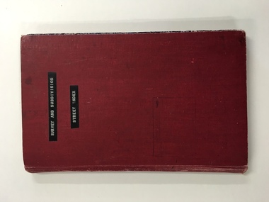
Register, Survey & subdivision street index, 1930s
This is a book with the City of Warrnambool surveys and subdivisions listed under the street names. It covers the period from 1938 to 1975. The information is listed under the headings of plan number, street name, section, allotment, date and remarks. The information contained therein would now be held as electronic data in the Council Records Department. Warrnambool, founded in 1847, became a municipality in 1856, a Borough in 1863, a Town in 1883 and a City in 1918. This book is of considerable interest because it lists Warrnambool streets from 1938 to 1975 and gives details of the subdivisions and surveys during that time. It will be very useful for researchers. This is a foolscap-size hard-cover book with a red cover with a mottled-blue pattern paper inside the covers. It has 95 pages with ruled red and blue lines. It has a handwritten alphabet index throughout the pages. The contents are handwritten in blue, green and black ink. The inside binding has been mended with adhesive tape and one page is loose. The book lists subdivisions in the City of Warrnambool under the heading of the street names and covers 1938 to 1975. The cover is somewhat grubby.Front Cover (in plastic tape): ‘Survey and Subdivision. Street Index’warrnambool city council, warrnambool streets and subdivisions