Showing 5882 items
matching residential
-
 Kew Historical Society Inc
Photograph - Flooding of the Yarra Valley at Kew East, 1974
Flooding of the Yarra Valley, including that section of the Yarra bordering Kew and Kew East in the north and west of the municipality, was a regular occurrence. Extreme flood events of the Yarra River are recorded to have occurred in 1891, 1901, 1916, 1923 and 1934. The Municipality of Kew's response to these floods was to enact planning decisions restricting residential development in flood prone areas following the floods of 1916, 1921 and 1934. While floods continued after the development of the Upper Yarra Reservoir (construction 1948-57), the regularity and extent of these inundations diminished. During the nineteenth century, the land abutting the south side of the Yarra in Kew was devoted to dairy farming. In the twentieth century, before and after the construction of the Eastern Freeway, much of this low-lying area was used as golf courses and public parks.Late example of the capacity of the Yarra Valley at Kew to flood, even though drainage works and the Upper Yarra Reservoir had reduced their regularity.Original black and white print photograph of the low-lying land at East Kew under floodwater on 16 May 1974. The vantage point of the photographer is at Willsmere Road. The road itself is underwater.Annotation verso: "Willsmere Rd / Same as No.7 / 16 May 1974 11.15am"floods, yarra river, willsmere road -
 Kew Historical Society Inc
Photograph - Flooding of the Yarra Valley at Kew East, 1974
Flooding of the Yarra Valley, including that section of the Yarra bordering Kew and Kew East in the north and west of the municipality, was a regular occurrence. Extreme flood events of the Yarra River are recorded to have occurred in 1891, 1901, 1916, 1923 and 1934. The Municipality of Kew's response to these floods was to enact planning decisions restricting residential development in flood prone areas following the floods of 1916, 1921 and 1934. While floods continued after the development of the Upper Yarra Reservoir (construction 1948-57), the regularity and extent of these inundations diminished. During the nineteenth century, the land abutting the south side of the Yarra in Kew was devoted to dairy farming. In the twentieth century, before and after the construction of the Eastern Freeway, much of this low-lying area was used as golf courses and public parks.Late example of the capacity of the Yarra Valley at Kew to flood, even though drainage works and the Upper Yarra Reservoir had reduced their regularity.Original black and white print photograph of the low-lying land at East Kew under floodwater on 16 May 1974. The photograph is of Hyde Park looking north-east.Annotation verso: "Hyde Park looking nth-east / Flood Level / 16 May 1974 11.15am / R.L. 46.61"floods, yarra river, hyde park -
 Kew Historical Society Inc
Photograph - Flooding of the Yarra Valley at Kew, 1974
Flooding of the Yarra Valley, including that section of the Yarra bordering Kew and Kew East in the north and west of the municipality, was a regular occurrence. Extreme flood events of the Yarra River are recorded to have occurred in 1891, 1901, 1916, 1923 and 1934. The Municipality of Kew's response to these floods was to enact planning decisions restricting residential development in flood prone areas following the floods of 1916, 1921 and 1934. While floods continued after the development of the Upper Yarra Reservoir (construction 1948-57), the regularity and extent of these inundations diminished. During the nineteenth century, the land abutting the south side of the Yarra in Kew was devoted to dairy farming. In the twentieth century, before and after the construction of the Eastern Freeway, much of this low-lying area was used as golf courses and public parks.Late example of the capacity of the Yarra Valley at Kew to flood, even though drainage works and the Upper Yarra Reservoir had reduced their regularity.Original black and white print photograph of the low-lying land at East Kew under floodwater on 16 May 1974. The photograph is taken from 43 Kellett Grove.Annotation verso: "Kellett Gve No.43 / Flood Level / 16 May 1974 11.40am"floods, yarra river, kellett grove -
 Glen Eira City Council History and Heritage Collection
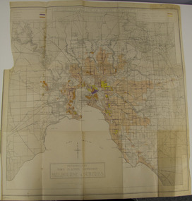
Map - Map, zoning, "DISTRIBUTION AND USE OF EXISTING PROPERTY. MAP NO. 6.", 1929
The map titled: “Distribution and use of Existing property map No. 6” (Metropolitan Town Planning Commission Melbourne and Suburbs) is of historical significance. It is listed on page 168 of Chapter 4 the Zoning section of the "Plan of General Development Melbourne Report of the Metropolitan Town Planning Commission 1929" - Melbourne's first strategic plan. Map No. 6 is mentioned throughout Chapter 4 of the 1929 Report. It states on page 156 that this Map was created to graphically illustrate the data collected by the Planning Commission. The Map illustrates the general distribution of uses of existing property throughout the metropolitan area. The coloured sections show the areas which were developed or were in the process of development in 1929. The colours indicate the distribution of uses in the developed areas. The pink coloured areas, which include Caulfield, were almost completely residential.1929, metropolitan town planning commission, melbourne, suburbs -
 Surrey Hills Historical Society Collection
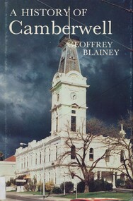
Book, A history of Camberwell, 1980
In 1964 Camberwell City Council commissioned Professor Geoffrey Blainey to first write this history. Since that time, many changes have taken place and therefore the Council asked Professor Blainey to bring the book up to date. Bibliography, includes index. The author presents a century of pioneering development and endeavours. He has traced the coming of the wood-cutters and the farmers, the transition from rectangular paddocks to a grid of roads and streets, the growth from shire to borough, town and city, the filling up of thirteen squares miles into residential suburbia - in successive waves of invasion, along new transport routes - including the Outer Circle Railway. Substantial chapters cover the War Years and the progress of Camberwell since the 1960s have also been included in this edition. 134p; ill;camberwell, victoria, market gardens, tolls, railways, mayors, boroondara road board, borondara shire, councillors, (mr) (prof) geoffrey blainey -
 Vision Australia
Administrative record - Text, Royal Victorian Institute for the Blind annual report 1981-1982, 1981-1982
Articles in annual report include: the official opening of the educational camp at Romsey, introduction of a Hartley 3909 Mini Computer, increasing move away from residential services with 74% of school children supported in learn at their local school, hydrotherapy unit (spa) and Versa Brailler purchased for school, 2 week ski camp offered at RVIB ski lodge at Mt Baw Baw, employment continuing in packaging and assembly, plant nursery, maintenance of St Kilda Road and Raleigh Street sites, kiosks at RMIT, Melbourne University and the Institute, trial scheme launched with Alfred for work experience in various roles, introduction of 4 track tapes in library and reduction of Clarke & Smith tapettes, and development of 16mm film 'The Mediators' for use by Public Relations department.1 volume of printed materialroyal victorian institute for the blind, corporation records -
 Vision Australia
Administrative record - Text, The Association for the Blind Illawarra Community Centre committee meeting minutes 12/1/1985 to 5/12/1988, 1985-1988
These meetings were held at the Illawarra Community Centre and the minutes include Present, In attendance, Apologies, Business arising from previous minutes, correspondence, Life Governors, Accounts paid to be ratified, Statements, receipts and payments, Reports including Financial, Executive Director, Staff, Manager, General Committee, Geelong Illawarra Auxiliary Association for the Blind (AFB) general business and date of next meeting. 4/2/1986 Mr Cook reported that the AFB90th birthday, held at Dallas Brooks Hall, was most successful and the Association is now in a more favourable financial position. 8/11/1988 The Executive Director reported that the homes of the Association for the Blind in Victoria are being reviewed and upgraded in all aspects of residential care. The next round of expansion plans include Bright, Bendigo, Ballarat and Mt. Eliza. 1 folder of loose papersassociation for the blind, illawarra community centre -
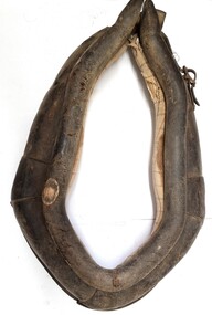
 Wodonga & District Historical Society Inc
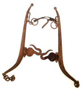
Functional object - Hames from Horse Harness, 1930s
These hames are part of the harness used by the family of Michael Conway who established a dairy farm of 35 acres in Wodonga in 1940. He and his wife Catherine nee Carroll settled there and raised 5 children. Before coming to Wodonga Michael carried on a bakery business at Urana. The hames were part of the harness attached to the horse which pulled his bakery cart. In Wodonga Michael Conway built a 2 bail dairy and milked up to 20 cows, separated the cream from the milk by hand and sold it to the local butter factory of Holdensen and Nielsen. In later years only whole milk was sold. The farm was on the outskirts of East Wodonga. Michael Conway died on 6th January 1945. The farm was later sold for residential and industrial development and includes Conway Court.This item has a clear connection to the family of Michael Conway of Wodonga, Victoria2 metal sections shaped to fit around the exterior of a horse collar. They are joined at the lower end by a chain and upper end by a leather strap. Approximately halfway up each section a hinged hook is located to which chains are hooked and attached to the cart. Towards the upper end is attached a ring through which reins pass before being connected to the bit.michael conway wodonga, horse harnesses, dairy industry wodonga -
 Wodonga & District Historical Society Inc
Functional object - Leather Horse Collar
This horse collar was made and used by the family of Michael Conway who established a dairy farm of 35 acres in Wodonga in 1940. He and his wife Catherine nee Carroll settled there and raised 5 children. Before coming to Wodonga Michael carried on a bakery business at Urana. This collar was used to attach the hames, harness and chains which pulled his bakery cart. In Wodonga Michael Conway built a 2 bail dairy and milked up to 20 cows, separated the cream from the milk by hand and sold it to the local butter factory of Holdensen and Nielsen. In later years only whole milk was sold. The farm was on the outskirts of East Wodonga. Michael Conway died on 6th January 1945. The farm was later sold for residential and industrial development and includes Conway Court.This item has a clear connection to the family of Michael Conway of Wodonga, VictoriaA handmade leather horse collar padded with straw and cloth. It has metal buckles secured by leather straps which are held in place with metal studs.michael conway wodonga, horse harnesses, dairy industry wodonga -
 Bendigo Historical Society Inc.
Document - MCCOLL, RANKIN AND STANISTREET COLLECTION: INDENTURE, GOLD MINING LEASE CROWN AND RONALD ALEXANDER RANKIN, BENDIGO, 24th June 1941
6 page document, Gold Mining Lease 11166, plus map. Indenture between Crown (King George VI) and Ronald Alexander Rankin of Bendigo, dated 24th June, 1941. Map No. 11166 Bendigo, Mining District of Bendigo, Parish of Sandhurst, County of Bendigo. Map shows lease 11166 marked in yellow with shaft, ore bins and tramway marked. Belle Vue Road , Adam Street and Griston Street shown on map. ( Golden Gully area) Dams indicated on lease holdings. Other lease holdings: 1675 T.L.9858, 10990, 11013, 11062, 11165, 11063 (void) 1172 W.R. (dam thereon) 9882 (void). Some residential lots marked along Belle Vue Road, and Adam Street. On bottom of map 21.8.41 in pencil. On last page of document : North Deborah Mining Company now the proprietor of the within described estate by transfer registered on 11th November 1914.bendigo, mining, north deborah lease, belle vue road, adams street, griston street, golden gully, ronald alexander rankin, north deborah mine. -
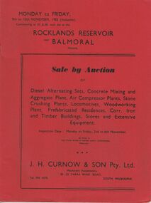 Bendigo Historical Society Inc.
Document - IAN DYETT COLLECTION: AUCTION CATALOGUE - ROCKLANDS RESERVOIR
Red covered catalogue for a Sale by Auction at Rocklands Reservoir near Balmoral, Vic. On the 9th to 13th November, 1953 (inclusive). For sale are Diesel Alternating Sets, Concrete Mixing and Aggregate Plant, Air Compressor Plants, Stone Crushing Plants, Locomotives, Woodworking Plant, Prefabricated Residences, Corr. Iron and Timber Buildings Stores and Extensive Equipment by order of The State Rivers & Water Supply Commission, Melbourne. Pasted in the front of catalogue is a slip to write name, address and phone number on and to give to clerk when making their first purchase. A typed note loose in the front of catalogue mentions that the time for removal of houses and buildings has been increased from four weeks to three months and goods would be at purchaser's own risk after time of sale. Descriptions of some of the items for sale. Catalogue has Ground Plans of the eight different residential houses. J. H. Curnow & Son Pty. Ltd. Were the auctioneers.business, auctioneers, j h curnow & son pty ltd, ian dyett collection - auction catalogue - rocklands reservoir, the state rivers & water supply commission, j h curnow & son pty ltd, balmoral combined women's associations, prahran telegraph printing co -
 Kew Historical Society Inc
Photograph, J F C Farquhar, A View in Studley Park Road, 1891
At the beginning of the 1890s, the Kew businessman and Town Councillor, Henry Kellett, commissioned J.F.C. Farquhar to photograph scenes of Kew. These scenes included panoramas as well as pastoral scenes. The resulting set of twelve photographs was assembled in an album, Kew Where We Live, from which customers could select images for purchase.The preamble to the album describes that the photographs used the ‘argentic bromide’ process, now more commonly known as the gelatine silver process. This form of dry plate photography allowed for the negatives to be kept for weeks before processing, hence its value in landscape photography. The resulting images were considered to be finely grained and everlasting. Evidence of the success of Henry Kellett’s venture can be seen today, in that some of the photographs are held in national collections.It is believed that the Kew Historical Society’s copy of the Kellett album is unique and that the photographs in the book were the first copies taken from the original plates. It is the first and most important series of images produced about Kew. The individual images have proved essential in identifying buildings and places of heritage value in the district.This is the earliest known photograph of the exterior of Byram (later Tara Hall). It shows the original red brick fence, its asymmetrical gate and gateposts, with a large terra cotta gargoyle surmounting the higher of the two. The architect, Edward Kilburn designed Byram in the Arts & Crafts style for the industrialist George Ramsden. Construction began in 1888 and was reputed to have lasted three years. The mansion had frontages to Studley Park Road and Stevenson Street, including gardens laid out with great taste, including pleasure grounds, tennis lawn, fruit and flower garden, and paddock. The size of many of the trees in the garden indicate that many survived from the garden of Clifton Villa, the previous single-storeyed house built on the site by the Stevenson brothers. Byram had views to Melbourne and Port Phillip Bay. The house was demolished in 1960, despite opposition from the National Trust (Victoria), and its gardens subdivided into residential allotments.A View in Studley Park Roadkew illustrated, kew where we live, photographic books, henry kellett, byram, tara hall, goathlands -
 Kew Historical Society Inc
Plan, J R Mathers & McMillan, 5 Splendid vVlla Allotments,: Segtoune St. & Windsor St., Kew, 1928
Prue Sanderson, in her groundbreaking ‘City of Kew Urban Conservation Study : Volume 2 - Development History’ (1988), summarised the periods of urban development and subdivisions of land in Kew. The periods that she identified included 1845-1880, 1880-1893, 1893-1921, 1921-1933, 1933-1943, and Post-War Development. These periods were selected as they represented periods of rapid growth or decline in urban development. An obvious starting point for Sanderson’s groupings involved population growth and the associated economic cycles. These cycles also highlighted urban expansion onto land that was predominantly rural, although in other cases it represented the decline and breakup of large estates. A number of the plans in the Kew Historical Society’s collection can also be found in other collections, such as those of the State Library of Victoria and the Boroondara Library Service. A number are however unique to the collection.Subdivision plans are historically important documents used as evidence of the growth of suburbs in Australia. They frequently provide information about when the land was sold on which a built structure was subsequently constructed as well as evidence relating to surveyors and real estate and financial agents. The numerous subdivision plans in the Kew Historical Society's collection represent working documents, ranging from the initial sketches made in planning a subdivision to printed plans on which auctioneers or agents listed the prices for which individual lots were sold. In a number of cases, the reverse of a subdivision plan in the collection includes a photograph of a house that was also for sale by the agent. These photographs provide significant heritage information relating house design and decoration, fencing and household gardens.In 1928, five residential allotments bordering Segtoune and Windsor Streets were advertised for sale as part of a subdivision. Four of the blocks faced Segtoune Avenue. The auctioneers proclaimed the advantages of the sites: ‘Situate one minute from the High Street Electric Tram, which now runs direct to Spencer Street via Bridge Road and Flinders Street. Opposite the East Kew Railway Station (Outer Circle Line), which may be reopened In connection with the new Line from Kew to Doncaster; Adjacent lo the Kew Recreation Reserve, Sports Oval, and Swimming Bath; Half Minute from the Shopping Centre of East Kew, Accessible to the State School and Other Educational Centres’. The Harp of Erin Hotel and the route of the Outer Circle Railway line are marked on the plan. The Recreation Reserve and Sport Oval refer to Victoria Park. The Swimming Baths were located on the site of the current Kew Recreation Centre.subdivision plans - kew, segtoune street -- kew (vic.), windsor street -- kew (vic.) -
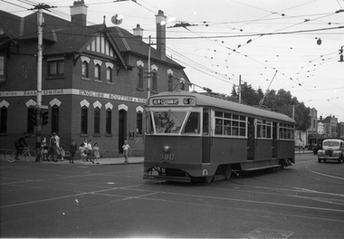 Melbourne Tram Museum
Negative, 9/02/1951 12:00:00 AM
Black and white negative, by Wal Jack, of PCC 980, northbound bound in Glenferrie Road at High Street with the destination of Kew Cotham Road. The Bank was replaced by a more modern looking building during the 1970's. In the background is the ES&A bank on the corner. Jane Nigro advised 9/9/2020: "1907 Photo of the E. S. & A. Bank on the corner of High Street and Glenferrie Road, Malvern. In 1885 land on corner of Glenferrie Road & High St. (40' x 150') was purchased by E.S. & A. Bank. A condition of sale was that the bank erect on the land a 'substantial brick building to be used as a branch bank', within 24 months. The E.S. & A. Bank, single-storey four roomed brick, was built in 1888. The first manager was Frederick Leonard. In 1907 a second storey, including residential quarters for the manager, was added to bank at a cost of £1400.The Bank was demolished in 1958-9and replaced with present building."trams, tramways, pcc class, glenferrie road, route 69, kew- cotham rd, tram 980 -
 Eltham District Historical Society Inc
Photograph, N. J. Tillings Timber Factory, 15 June, 1975, 15/06/1975
N. J. Tillings Timber Factory was part of the Brougham Street, Light industrial area, Eltham. This is one of 7 B/W 8x10 inch photos with notes on obverse by Dick Crichton. Accompanying letter from Florence Chrichton 2013 : "Originally sent to Shire of Eltham Engineer, Mr. McDonald. [These photographs were part of their campaign to the Shire of Eltham in 1975] claiming that the zoning regulations were being breached by the occupants of various factories in the nearby light industrial zone [Brougham Street, Eltham] - to the detriment of those living in adjoining residential zones, and that, despite .. earlier objections and complaints, nothing was done about it." "The Tilling Group was established in November 1963 and began as a small factory in Eltham Victoria. The company now has large, modern offices and warehouses in most major cities across Australia" - http://www.tilling.com.au/about-us1 black and white photograph printed with white borderInscribed on back: "N.J. Tillings 3rd and recently installed extractor fan at rear of premises. Eltham Council Officers continue to state that such installations require no permit even though the installation involves a change in the nature of the firm's operations. Residents believe that this firm (and others) are no longer classifiable as 'light industrial.' Do residents have to act as watch-dogs to see that regulations are observed or will council officers in future carry out their obligations to do so." industrial estate, brougham street, eltham, 1975, bolton street, dick crichton, n.j. tillings, timber factory, shire of eltham, milling, fan -
 Melbourne Legacy
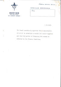
Document - Memorandum, Establishing hostels for Junior Legatees, 01/10/1942
An inter-club memorandum advising of the Board's approval to establish a hostel for Junior Legatees, later to be known as Holmbush, and ultimately as Blamey House. Holmbush was the first residential accommodation operated by Melbourne Legacy, and was established in 1942. It accommodated boys aged between 9 and 19, usually attending secondary school. In 1956, Holmbush became known as Blamey House. It was located not far from another Legacy home, Stanhope (1245 Burke Road). Residents of Holmbush and other Legacy homes were the children of deceased ex-servicemen. Sometimes residents at Legacy homes were both children of ex-servicemen and wards of state. In 1956, Blamey House, another Legacy children's home formerly in Beaumaris moved into the Holmbush property in Kew, and it was renamed Blamey House. Location 1942 - 1956? Address - Holmbush was located at 1267 Burke Road, Kew. Location: Kew Early record of the establishment of one of Melbourne Legacy's residences.Typed memo, black on white with blue letterhead outlining the agreement of the JLC board to proceed with the hostel for boys.residences, holmbush initial negotiations -
 Bayside Gallery - Bayside City Council Art & Heritage Collection
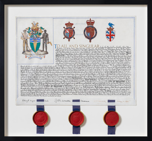
Document - Certificate, City of Brighton Coat of Arms, 1970
The Coat of Arms, represents Brighton City Council's "growing awareness of the importance of formality and correct symbolism in local government". It replaced the council's crest of a pier and yachting scene and was used as council's seal, emblem on its flag and letterhead. The new Coat of Arms, drawn up by the College of Arms in England, depicts the progression from a seaside gardening community to a modern residential city. The prominent forms are on the shield-like coat of arms include waves and a Lymphad (a ship, symbolic of the sea); a market gardener; an aboriginal man; two horns plenty with abundant fruit and vegetables (the wealth and plenty) and Elster Creek (now Elster Canal). It is underscored by the motto "By their fruits, ye shall know them". Brighton was first incorporated as a borough on 18 January 1859, it became a town on 18 March 1887 and was proclaimed a city on 12 March 1919.Ink and gouache on parchment with wax seals. Allocates a Coat of Arms to the City of Brighton, by the College of Arms in London on 08/09/1970. The Coat of Arms is located on the upper left quadrant and has the following parts: the crest, the wreath, the helmet and mantle, the shield, the supporters, the compartment and the motto. The crest is two cornucopias with fruits and vegetables, above which sits a seagull. The mantle above the helmet is in green and gold. The shield is also green and gold with a lymphad (ship), and blue and white waves, representing the sea. The market gardener, holding a hoe, and Aboriginal figure, bearing a boomerang, support the shield and stand upon the compartment which is soil with a representation of Elster Creek. A ribbon below contains the motto in 'FRUCTU NOSCITUR'. The certificate text explains the origins of Brighton and the parts of the coat of arms. At the bottom of the folded parchment are three signatures and titles, below which three red wax seals in gold tin containers hang from blue ribbons.coat of arms, certificate, city of brighton, college of arms, market gardener, aboriginal, wax seal, elster creek, lymphad, fructu noscitur, letters patent, armorial bearings, heraldry, seal -
 Kew Historical Society Inc
Legal record - The Indenture, Crown Portion 86, otherwise known as 'The Morgan Deed', 1852 (and later)
This indenture once formed part of the City of Kew's Municipal Collection. Cr. W.D. Vaughan in his history 'Kew's Civic Century' (1960) records on page 194 that: "The original deed of conveyance of the land being all of Crown Portion 86, Kew, purchased by John Quick, James Venn Morgan, Samuel Derrick and William Derrick was presented by the Historical Society of Victoria on behalf of Mrs Fryer, a daughter of the later J.V. Morgan, to the [Kew] Council on August 5, 1941. Crown Portion 86, comprised all the land between Cotham Road and High Street to an alignment opposite the east boundary of Glenferrie Road. On it the first residential house was built by Mr. J.V. Morgan in 1852." Following the donation, the Indenture was surrounded by other original related text and explanatory notes and framed. The resulting framed documents are the largest framed objects in the collection.The Indenture and the accompanying contextual documents are some of the most historically significant manuscripts to have survived since the settlement of Kew in the 1850s. They provide a link to Kew's most famous pioneering families.Framed 1952 Indenture recording the sale of land in Kew to pioneering Kew families.james venn morgan, john quick, william derrick, samuel derrick, kew (vic) - history, kew (vic) - pioneers, samuel watts, kew (vic.) — municipal collection -
 Kew Historical Society Inc
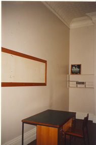
Photograph, Former Willsmere (Kew) Mental Hospital, c.1990
The former Kew Lunatic Asylum, was commenced in 1856 and opened in 1872. At various stages of the institution's history it was named the Kew Lunatic Asylum (1872-1956), Kew Mental Hospital (1956-1960s), Willsmere Mental Hospital (c.1960s-1982), and the Willsmere Unit (1982-1989). The Kew Idiot Ward/Asylum (1887-1929) was initially part of the Asylum. Later it was called Kew Children’s Cottages (1929-62), Kew Training Centre (1962-c.97), and Kew Residential Services (c.1997-2008). Most of the records relating to these former institutions are held by the relevant Government Department or by the Public Record Office Victoria. Due to the location of these two institutions in Kew, the Kew Historical Society also holds an extensive photographic archive as well as significant collections of personal papers collected by staff who worked at these institutions.This photograph is one of a series donated to the Society by the photographer, taken following the closure of the Willsmere Unit, and before its redevelopment as a private residential complex. The series is historically significant in that it depicts interior and exterior views of the former institution that were subsequently altered or demolished during redevelopment. A number of the 'views' are socially significant as they allow us to examine the ways in which public institutional architecture in the 19th and 20th centuries responded to the needs of those with perceived mental health issues. Colour snapshot of a part or section of the former Willsmere (Kew) Mental Hospital, taken following its decommissioning and before its sale and redevelopment.kew lunatic asylum, kew mental hospital, willsmere mental hospital, willsmere unit, health & human services, mental health, institutional architecture -
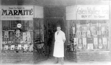 Surrey Hills Historical Society Collection
Photograph, Edward Blanchford Wright's grocery shop, Canterbury Road, Surrey Hills
Edward Blatchford Wright was born in 1894 in Birmingham, son of Edward Wright and Florence Emuss. It is not known when he migrated to Australia but he served in the AIF during WW1, seeing action in France. On enlistment aged 20 years 9 months, he gave his occupation as farmer. He married Gertrude Matilda Wain in 1919. He came to Surrey Hills c1924. He was a grocer in the area for several decades with shops in Canterbury Road. In 1942 he is listed at 235 Union Road. This was a residential address. Alan Holt's Surrey Hills property register places him at 365 Canterbury Road (c1920-1930) and 359 Canterbury Road (c1930-1940). He died in 1972 in Mont Albert. His last electoral roll entry in 1968 gives 18 Serpentine Street, Mont Albert. He and his wife are buried in Burwood Cemetery.Black and white photo of the exterior of Edward Blanchford Wright's grocery shop in Canterbury Road, Surrey Hills. The screen door is open and William Reynolds stands in the opening, dressed in a long white coat. The window displays are stacked high with cans and packages and large signs advertising the prices of goods. There is advertising on the windows for Marmite, Glen Valley tea, Preservene soap and Brockoff's biscuits. advertising, shops, grocers, businesses, union road shops, edward blatchford wright, william reynolds, burwood cemetery, world war 1, canterbury road -
 Melbourne Legacy
Slide, Blamey House, 1960s
Blamey House was one of the residences used by Legacy as a home for Junior Legatees. From 1942-1981 Legacy provided residential accommodation for junior legatees who may have been left orphans, or whose mother may have been unable to care for them herself, or they needed to stay in Melbourne for further education. Short term accommodation for children could be provided, for instance if a widow needed hospital care. The property at 1267 Burke Road was known as Holmbush from 1942 until 1956. The name was transferred to this property from another residence in Balcombe Road Beaumaris when it was sold in the mid 1950s. Was with many other slides taken in the 1950s and 1960s. The slides have been photographed to make digital images and moved to archive quality sleeves. In many cases the original images were not well focussed and the digital image the best available.A record of the residence in Burke Road named Blamey House.Colour slide of Blamey House viewed from the road in a red edged Kodachrome cardboard mount.Printed on reverse in red ink 'Kodachrome Transparency / Processed by Kodak'. Handwritten in blue ink 'Blamey House'. Imprinted slide number in black ink '1'.residences, blamey house -
 Melbourne Legacy
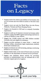
Pamphlet, Facts on Legacy, c.1990
This is an example of Melbourne Legacy promotional material. It is possibly from the 1990's as it was in a folder with marketing material from that time. The brochure mentions 119,000 widows and 3,000 children enrolled Australia wide. It lists the types of assistance as: "rental and housing, welfare, educational, legal, employment, medical, dental and residential care". The main time of year for fundraising is September when Legacy holds 'Badge Week'. Often there is a celebrity who gives his or her time as 'Personality of the Year'. Examples are Sir Weary Dunlop (1992), Clive James (1993), the Scott family (1994), The Emmanuel brothers (1995), Daryl Somers (1996 and 1997), and Patsy Adam Smith (1994). Was in a folder with marketing material from the 1990s to 2009, see items 01240 to 01258. The collection shows the types of marketing materials that were produced and the celebrities that were helping Legacy.An example of promotional material from the 1990s. Marketing material and photos were compiled and released to newspapers, also printed as brochures and sometimes as stickers and collection tin wrappers.Colour promotional leaflet to explain Legacy's work.legacy promotion, badge appeal, legacy week, marketing -
Warrnambool and District Historical Society Inc.
Document, Wollaston sale, 1919
This is a poster advertising the sale of part of the Wollaston Estate in Warrnambool in 1919. The sections for sale were Allotments 1, 18 and 19 which included the Wollaston Homestead. The original Wollaston property of 679 acres was selected by Thomas Manifold in the late 1840s. This land, on the northern side of the Merri River, near the Woodford Road was three kilometres from the Warrnambool town. The first farmer we know who leased the property was William Simpson. Walter Manifold inherited the property and he took it over in 1884. The swing bridge he built in 1890 still stands today. In 1919 the Closer Settlement Board of Victoria acquired Wollaston and 17 lots were sold to returned soldiers for farming purposes. By 1930 there were only five soldier settlers remaining. In 2009 further subdivision took place with lots sold for residential purposes. The homestead allotments were sold separately in 1919 with various owners of the homestead itself recorded since that time. This poster is of interest as it shows the areas of the Wollaston Estate which were sold in 1919. The history of this estate is well-documented and of importance in the history of Warrnambool. This is a sheet of paper with red and black printing and a map of the Wollaston Estate which is photo-lithographed. The sheet has been folded three times. It has some small tears at the top of the page. wollaston, history of warrnambool, walter manifold -
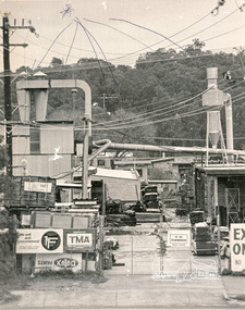 Eltham District Historical Society Inc
Photograph, N. J. Tillings Timber Factory, 15 June, 1975, 15/06/1975
N. J. Tillings Timber Factory was part of the Brougham Street, Light industrial area, Eltham. This is one of 7 B/W 8x10 inch photos with notes on obverse by Dick Crichton. Accompanying letter from Florence Chrichton 2013 : "Originally sent to Shire of Eltham Engineer, Mr. McDonald. [These photographs were part of their campaign to the Shire of Eltham in 1975] claiming that the zoning regulations were being breached by the occupants of various factories in the nearby light industrial zone [Brougham Street, Eltham] - to the detriment of those living in adjoining residential zones, and that, despite .. earlier objections and complaints, nothing was done about it." Wire gate and fencing in foreground of photo displays signs relating to timber products and Dulux Paints. "The Tilling Group was established in November 1963 and began as a small factory in Eltham Victoria. The company now has large, modern offices and warehouses in most major cities across Australia" - http://www.tilling.com.au/about-us1 black and white photograph printed with white borderInscribed on back: "Front entrance to N,J. Tillings timber yard showing part of extractor fan system installed to facilitate milling operations. Sound intensified due to position of mill in valley. Valley acts as a natural sound bowl. Eltham Council were warned of this some years ago." Includes diagram of residences in relation to mill and statement that tooter blast at least ten times per day. "#Note Residences in close proximity to sound source. Pen marks on front of photograph indicating points of interest.industrial estate, brougham street, eltham, 1975, bolton street, dick crichton, n.j. tillings, timber factory, shire of eltham, milling, fan -
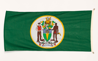 Bayside Gallery - Bayside City Council Art & Heritage Collection
Flag, City of Brighton flag
The coat of arms on this flag were granted by the British College of Arms in 1970 and represented Brighton City Council's "growing awareness of the importance of formality and correct symbolism in local government". It replaced the council's crest of a pier and yachting scene and was used as council's seal, emblem on its flag and letterhead. The new Coat of Arms, drawn up by the College of Arms in England, depicts the progression from a seaside gardening community to a modern residential city. The prominent forms are on the shield-like coat of arms include waves and a Lymphad (a ship, symbolic of the sea); a market gardener; an aboriginal man; two horns of plenty with abundant fruit and vegetables (the wealth and plenty) and Elster Creek (now Elster Canal). It is underscored by the motto "By their fruits, ye shall know them". Brighton was first incorporated as a borough on 18 January 1859, it became a town on 18 March 1887 and was proclaimed a city on 12 March 1919.Green flag with circular City of Brighton Coat of Arms in the centre. The central circle is white with a yellow edge, with a polychrome coat of arms featuring: the crest which is two cornucopia with fruits and vegetables, above sits a seagull. The mantle above the helmet is in green and gold. The shield is also green and gold with a lymphad (ship) and blue and white waves. The market gardener, holding a hoe, and Aboriginal figure, bearing a boomerang, support the shield and stand upon the compartment which is soil with a representation of Elster creek. A ribbon below contains the motto in blue 'FRUCTU NOSCITUR'.flag, brighton, city of brighton, coat of arms, college of arms, market gardener, aboriginal, elster creek, lymphad, fructu noscitur, armorial bearings, heraldry, cornucopia, by their fruits ye shall know them, motto -
 Kew Historical Society Inc
Plan - Subdivision Plan, Balwyn Theatre and Shop Sites, circa 1927-28, c.1927-28
The Kew Historical Society's map collection includes a substantial number of real estate subdivision plans, mainly of Kew but also of surrounding suburbs in Melbourne. Most of the subdivision plans date from the 1920s and 1930s when the districts old homes and local farmland were being split up to accommodate residential growth in the postwar period. These early plans were assembled by a local firm, Jas R Mather & McMillan, which had an office in Cotham Road. Many of the plans, and sometimes photos, were annotated by the agents. The ‘new’ Balwyn Picture Theatre was built and owned by Balwyn Theatres Pty Ltd in ca. 1928. By 1930, this first Balwyn Theatre was destroyed by fire after a break-in. Following the fire, a new cinema was constructed. This plan for a Cinema and eleven shops presumably dates from 1927/28 when the Company announced that this location in Whitehorse Road ‘was the most central and best suited [area] for their Theatre and shops’.Subdivision plans are historically important documents used as evidence for the growth of suburbs in Australia. They frequently provide information about when the land was sold as well as evidence relating to surveyors and real estate and financial agents. The numerous subdivision plans in the Kew Historical Society's collection represent working documents, ranging from the initial sketches made in planning a subdivision to printed plans on which auctioneers or agents listed the prices for which individual lots were sold. In a number of cases, the reverse of a subdivision plan in the collection includes a photograph of a house that was also for sale by the agent. These photographs provide significant heritage information relating house design and decoration, fencing and household gardens.The photograph may also be aesthetically significant depending on the importance of the photographic atelier.Subdivision plan showing the Balwyn Theatre and its adjoining shop sites in Whitehorse Road Balwyn. The 11 shop sites were noted for their depth (133 ft - 145 ft. [Map.0041]balwyn theatre -- balwyn (vic.), subdivisions -- balwyn (vic), subdivision plans -
 Vision Australia
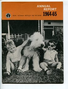
Administrative record - Text, Royal Victorian Institute for the Blind annual report 1964-1965, 1964-1965
Articles in annual report include: list of office bearers of the institute and officers of the institute, Introduction and summary, Residence nursery and school for blind children, Programme in rehabilitation, Blind welfare - Mr W Casey retired as welfare officer in December 1964 after a 40 year association, Institute busy factory - faced by serious competition from overseas the basket shop closed, No sugar packaging done since 1963, Employment of blind people, Splendid support from auxiliary, The future, Income and expenditure, Where there's a will there's a way. Events that occurred in 1964 : HRH Duchess of Gloucester visited residential nursery and school, four hundred members of auxiliary lined driveway to greet her, helped by nationwide drive of the Apex clubs this year more blind people are reading talking books, this year a specific department staffed full time was set to demonstrate aids and equipment for blind people.1 volume of text and illustrationsannual reports, royal victorian institute for the blind -
 Kew Historical Society Inc
Plan - Subdivision Plan, Raheen Estate Subdivision, 1960
Subdivision plans are historically important documents used as evidence of the growth of suburbs in Australia. They frequently provide information about when the land was sold on which a built structure was subsequently constructed as well as evidence relating to surveyors and real estate and financial agents. The numerous subdivision plans in the Kew Historical Society's collection represent working documents, ranging from the initial sketches made in planning a subdivision to printed plans on which auctioneers or agents listed the prices for which individual lots were sold. In a number of cases, the reverse of a subdivision plan in the collection includes a photograph of a house that was also for sale by the agent. These photographs provide significant heritage information relating house design and decoration, fencing and household gardens.The Raheen Estate Subdivision of 1960 involved the creation of 36 residential allotments and the sale of 34 of these. The land on which the subdivision was created had until 1960 formed part of the grounds of the mansion Raheen in Studley Park Road. In 1917, the Catholic Church had purchased Raheen and its lands. It was to become the home of Archbishop of Melbourne, Daniel Mannix, for 46 years. The sale of the subdivision took place three years before the Archbishop’s death. Subsequent archbishops were to reside at Raheen until its sale to the Pratt family in 1981. When the sale of the Estate was reported in the newspapers in 1960, it was described as the last big subdivision near Melbourne. At the auction, 33 of the 36 allotments were sold. The auction realised £315,750. Purchasers were advised that the vendor intended to keep lots 22 and 23. The alllotments in the subdivision required the construction of new roads. These included Eamon Court and Raheen Drive. The justification provided by the Church for the sale was that the estate was being sold to finance school building projects.subdivision plans - kew, studley park, raheen estate, eamon court, studley park road, coombes avenue, raheen drive -
 Bendigo Historical Society Inc.
Document - MCCOLL, RANKIN AND STANISTREET COLLECTION: INDENTURE, GOLD MINING LEASE 11081 CROWN AND HERBERT JACKSON LEED OF BENDIGO, 21st September, 1940
6-page document plus map, dated 21st September 1940, between the Crown and Herbert Jackson Leed, for the land shown on the accompanying map 'indicated by yellow colour' Depths indicated on lease document. On map: Mining District of Bendigo, County of Bendigo, Parish of Sandhurst. No. 11081. Net Area 24 acres, 3 roods, 3 perches. Signed by Herbert Leed and ?Walsh, Warden Clerk, Bendigo. Map shows lease holding 11081 coloured yellow. Other leases: no's. 9882 11081, 11034, 11080. Streets: Fletcher Street, and Belle Vue Road. Gullies: Derwenters Mistake Bully and Pig Face Gully on lease 11081. Quarry Hill Recreation Reserve marked and some residential allotments. Water race indicated on map. On back of document: ; Deborah United Gold Mining Company No Liability of Charing Cross Bendigo is now the proprietor of the within described estate by transfer registered on 21st November 1940 and numbered 1795202.bendigo, mining, deborah united gold mine, herbert jackson leed, deborah united gold mining. major general sir winston joseph dugan -
 Department of Health and Human Services
Photograph, Winlaton
WINLATON 1956 - 1993 • Established in 1951 with the name “Winlaton” the property was a children’s home run by the Mission of St James & St John. • By 1953 it was acquired and ran as a state facility under the same name (Winlaton), for female offenders and for girls under protection orders - otherwise known as ‘wards of the state’. • By the time of its closure in 1993, it was operating under the name “Nunawading Youth Residential Centre”, housing both males and females. WINLATON YOUTH TRAINING CENTRE By 1956, the state had constructed a purpose-built facility at Winlaton which would cater for both girls, and young women, who were under either a protection order/ward or who were female juvenile offenders. Some of the juvenile offenders were transferred to Winlaton from other facilities such as Turana, originally called the Royal Park Depot, due to overcrowding, or from convents. With the new facilities Winlaton, supposedly, could offer a separate training, education and treatment regime for those girls or young women who had been admitted under protection orders separately to those who had been committed under a custodial order. With this focus on training and rehabilitation the facility had 3 residential sections, or cottages. A Winlaton “trainee”, showing signs of good behaviour and progress, could be promoted up through any of the 3 cottages and likewise demoted down with bad behaviour. However, by 1957 one of the 3 cottages at Winlaton housed sentenced offenders and wards of state together. A 4th hostel – named ‘Leawarra’ - was added in 1959 which functioned as a reward, or privilege, for residents deemed worthy. Of note, this hostel kept offenders segregated from wards of the state. Juvenile offenders were termed as “trainees” through the Social Welfare Act 1960. By 1985 Winlaton was restricted to only providing programs for young offenders. CLOSURE OF WINLATON The population of Winlaton peaked in the mid-1970s with approximately 100 “trainees” and this population then declined to approximately 25 by 1991 when it closed under the name “Winlaton”. https://www.findingrecords.dhhs.vic.gov.au/collectionresultspage/Winlaton https://www.findandconnect.gov.au/ref/vic/biogs/E000192b.htm