Showing 3226 items
matching road map
-
 Melton City Libraries
Map, Streets of Melton, 1963
... TULLIDGE St Road marked on 1861 map UNITT... Agriculture, breed of sheep CHESNEY Road was re named ( Minns ...MELTON’S STREETS Heritage Week 2014 What’s in a Name? Alphabetical List Aboriginal place names, Early Family Names and landowners, Agricultural, Shop and Commercial premises, Places and Events Melton & District Historical Society Street Naming Project 1972 – c 1998 Suburb Name – KURUNJANG - Kirkton, 1972, Brookfield, West, 1988 Melton and Town Centre - A joint collaboration with the Shire of Melton and Subdivision Developers ARNOLD Court – Family house - Arnolds Creek ALKEMADE Drive Family – Lime kilns Coimadia ALEXANDRA Street 1902 – Corination of King Edward VII and Queen Alexandra AVIATOR Place Event, location of plane crash – Jimmy Melrose 1936 Adina ?Annibee - Anniba? Agricultural Avon court .. .. BAKERY Square - Location of Jongebloed shop, bakehouse and stables BALUK Place Aboriginal BARLEYCORN Place Agricultural BILLING Place Name of Jimmy Melrose Uncle Noel Pemberton Billing BLACKWOOD Drive - Alexander Blackwood 1860c Registrar BARRIES Road C. E. Barrie “Darlingsford” farmer 1911, chaff mill owner BROOKLYN Road Staughton family residence. 1875 – Dismantled c 193? CAHILL Drive Family - Glenville Dairy CAMERON Court Family Canopus Place ? CANALLAN Drive Early Surveyor CAMPBELL Court Aviation – Melrose passenger 6th July 1936 CARBERRY Drive Michael, early landowner family CAREW Court Edward and Michael. Royal Hotel. Vera (Carew) Forran Singer - Opera CASEY Court Family CASHIN Court Family CHEVIOT Court Agriculture, breed of sheep CHESNEY Road was re named ( Minns Road being duplicated c 1973) CHRISTINA Crescent Christina McPherson, daughter of James and Mary Mary McPherson. Died 1955 aged 85 years COLLYER Close a deleted street (parallel to Yuille) re-used CORRIEDALE Road Breed of sheep CORR Court Teacher at first school, landowner CROXTON Court Name of the Hornbuckle and Knox family home DALEY Court - William Daley and family 1865 Bootmaker High Street DARLINGSFORD Boulevard - Name of early homestead Thomas B Darling 1853 DJERRIWARRH Court - Parish County of Bourke - very early map. DODEMAIDE Place Early land owners - Melton Football Team had 6 brothers playing c 1924 DONALD Court McPherson family 6 generations in Melton in 1936 DOUGAL Court DUNCAN Court .. .. DUNVEGAN Circuit Home of the McPherson family, castle Isle of Skye Name of bluestone house Smith Street (now at Willows) EMIL Court Jongebloed family EXELL Avenue Farming family Melton Sth- Closer Settlement 1907 EXFORD Road Exe former name of the Werribee river FARMER Court Name of early postmistress FERRIS Road John Ferris Farmer HANNAH Close First name of Hannah Watts – midwife HAYBALE Place Agricultural HELDER Court Early surveyor J Helder Wedge map HEWSON Street Winston Hewson Shire Engineer – check title c 1960 HENRY Street Township map c 1860 HESTON Street Heston Phoenix – C.J. Melrose plane HILDEGARDE Court Jimmy Melrose’s mothers name HOMESTEAD Close HORNBUCKLE Cres Farmers. Three members of family - Shire Presidents HURLEY Street Farmers IAIN Court Descendent of James and Mary McPherson JAMES MELROSE Drive Name appears on 2013 Melton information map JANG Place KURUN – jang KIRKTON Drive Name of the McPherson family home Toolern Vale Road KIRWIN Street Michael early landowners (deleted for freeway construction) KILPATRICKS Road Deleted when Barries Road was extended across Station Rd KOROROIT Court Early map, Parish of Kororoit. Creek name KNOX Circuit Family – Hornbuckle “Croxton Park” KURRUNJANG Drive Aboriginal name for people of the red earth – Suburb name Lara Place ? LLOYD Court Garage owners High Street. Laura lived to 100 years D 1955 LUBY Court John Luby – Crown Grant Land Title LITTLE Court MANNING Avenue Richard, hotel owner 1891 MARGARET Drive McPherson family McDONALD Street Melton South family name McKENZIE Street Township c1860 MORROW Street Early name MOWBRAY Crescent Name of English Melton, popularly believed origin of Melton MYERS Court Early setters c 1866 Crown Grant Land Title NIMMO Street Early name NIXON Street Name submitted by Mary nee Nixon Collins c1985 OLDERSHAW Road Early builder PALMERSTON Street Early township map c 1860 PEART Court Early name PENNYROYAL Avenue Plant growing by the creek. Early name used for the Toolern Toolam Creek PINKERTON Street Family name and early street map PINNACLE Crescent Agricultural - type of wheat PHOENIX Circuit C.J. Melrose Phoenix Heston Plane 2013 map PRATT Family PRIOR Court PYKE Place Brothers – early settlement 1838 RADFORD Court Land owners and business operators. Former Royal Hotel Grocer High Street demolished 1970 RAGLAN Court Hotel 19th century Lord Raglan RALEIGHS Road Oliver Reierson family (Norweigen) Shopkeeper – Dressmakers RIDDELL Drive (misspelt Riddle) Resident and land owner RODERICK Road McPherson family – a re occurring name ROLLAND Court Jones family ROSS Court Daniel. Landowner. Agnes Ross music teacher RUSSELL Court Robert. Early land surveyor of Melton 1853 RYAN Court Family early landowner. Member of the 1862 Road Board SHEBLER Place Augustus early Melton resident – Golden Fleece Hotel SHEEPFOLD Court Farming SHERWIN Court Sherwin Street earliest Township map– became Golf course SMITH Street Early township map. STRATHULLOH Circuit Strathtulloh Homestead. STAUGHTON Street Family – LARGE land owners Strachan ? SWANEY Court Marie Swaney earlier resident of Strathtulloh. SUTHERLAND Family name TOOLERN Street TOOLAM – TOOLERN Creek TULLIDGE St Road marked on 1861 map UNITT Street Early Township c 1860 WALLACE Square Cr Jack Wallace 5 terms as President 46 years unopposed WATTS Court Hannah Watts – midwife, cottage hospital WALSINGHAM Name of house of Minns family. From Walsingham Norfolk England WESTLEY Place Name of Jimmy Melrose Percival Gull Plane WESTLAKE Drive Early resident WHICKHAM Street Family Name Melton South WILSON Road Albert, Melton South YUILLE Street William Cross, early landowner, Rockbank run Zoomed in section of Melton Streets including Church and High Streetlandscapes of significance -
 The Beechworth Burke Museum
Geological specimen - Feldspathic Sandstone
Feldspathic arenites are sandstones that contain less than 90% quartz, and more feldspar than unstable lithic fragments, and minor accessory minerals.Feldspathic sandstones are commonly immature or sub-mature.These sandstones occur in association with cratonic or stable shelf settings. Feldspathic sandstones are derived from granitic-type, primary crystalline, rocks. If the sandstone is dominantly plagioclase, then it is igneous in origin Sandstone features prominently in public buildings throughout Victoria. Most of the sandstone used as dimension stone in the State came from three sources: the Heatherlie quarry in the Grampians (Silurian), the Bacchus Marsh area (Permian), and the Barrabool Hills near Geelong (Cretaceous).Sandstone features prominently in public buildings throughout Victoria, making this specimen special as it shows the materials used by Victorian building companies. Sandstone can also be crushed, crushed stone is used in the construction of roadways and road structures such as bridges, and in buildings, both commercial and residential. This specimen is part of a larger collection of geological and mineral specimens collected from around Australia (and some parts of the world) and donated to the Burke Museum between 1868-1880. A large percentage of these specimens were collected in Victoria as part of the Geological Survey of Victoria that begun in 1852 (in response to the Gold Rush) to study and map the geology of Victoria. Collecting geological specimens was an important part of mapping and understanding the scientific makeup of the earth. Many of these specimens were sent to research and collecting organisations across Australia, including the Burke Museum, to educate and encourage further study. A feldspar-rich sandstone, a sandstone intermediate in composition between an arkosic sandstone and a quartz sandstone, containing 10% to 25% feldspar and less than 20% matrix material of clay, sericite, and chlorite. Feldspathic arenite containing less than 90 percent of the composition of quartz. Feldspar is the main composition. Feldspathic arenite may contain fragments of unstable rock, and a little amount of other minerals such as mica and heavy minerals. Some feldspathic arenite have pink or red color because of the presence of potassium feldspar or iron oxide. There are also colored light gray to white. These sandstones are usually medium to coarse grained and can contain a high percentage of granules with angular until subangular roundness. The content of the matrix can appear as the rest up to more than 15 percent, and sorting of grains can present as moderate to poorly sorted. Feldspathic sandstones are generally immature in textural maturity. Feldspathic arenite can not be judged from the structure of the sediment. Bedding can emerge from the laminate parallel to the crossbed. Fossils may appear in the layer deposited on the sea. Feldspathic arenites usually appear on the craton or the continental shelf, which can be associated with conglomerate, quartz lithic arenite, carbonate rock, or evaporites. This sandstone may also appear on the succession of sedimentary basins deposited on an unstable or deep sea, and moving arc setting. According to Pettijohn (1963) Arkose make up about 15 percent of all sandstones. Some Arkose formed in situ when the granite and related rocks disintegrate and generate granular sediments. Most of the material feldspathic sandstones derived from primary crystalline granitic rocks, such as granite or metasomatic rocks containing abundant potassium feldspar. Mineral contained in sandstones is mostly a form of plagioclase feldspar derived from quartz diorite or volcanic rock. Feldspar contained on this sandstone comes from arid to cool climates when the chemical weathering process is reduced.sandstone, natural stone, feldspathic sandstone, burke museum, geology, geological, geological specimen -
 Orbost & District Historical Society
pamphlets, Princes Freeway - Orbost Section, 1976
Opened by the Hon. J A Rafferty, Minister for Transport, 25 November 1976, the bridge was the first of four bridges to be built as part of the freeway bypass of Orbost. Construction cost $2.4 million. This construction was an important development along the Princes Highway corridor through East Gippsland. The original highway approached the Snowy River at a very poor alignment, and several serious accidents had occurred at the Orbost end. In times of heavy flood, the highway on both sides of the river had been cut by floodwaters and during the 1971 floods, the highest ever recorded, the river was a mile wide at the crossing. Construction of the bridges commenced in January 1975, with an expectation to open the bridge across the Snowy River as soon as possible. Less than two years later, on 25 November 1976, the bridge across the Snowy River was opened to traffic, allowing the old bridge to be demolished. The remainder of the Orbost Bypass, both the floodplain crossings and the eastern section around the township itself, was declared ‘Princes Freeway’ and opened to traffic in December 1977. (ref http://mrv.ozroads.com.au) The Country Roads Board was the government authority for the construction and maintenance of main roads in Victoria between 1913 and 1983. It was succeeded by the Road Construction authority on 1 July 1983 and later merged with the Road Traffic Authority on July 1 1989 to form the Roads Corporation. James Cameron, an Orbost farming pioneer and Member of the Legislative Assembly, fathered the Country Roads Board. The opening of this Snowy River Bridge was an important development in the accessibility to the township of Orbost.Three coloured Country Roads pamphlets for the 'Princes Freeway - Orbost Section". On the front is a coloured photograph of the new construction over the Snowy River at Orbost. Inside is a program for a ceremony for the opening of the new Snowy River Bridge. There is also a black print map of the project. -
 Orbost & District Historical Society
book, Snowy River Mail as "Mail" Print, Princes Freeway Orbost Section, 2117.1 : 1976 2117.2 : 4.9.2013
The Snowy River Bridge, Princes Freeway, Orbost, Victoria was opened by the Hon. J A Rafferty, Minister for Transport, 25 November 1976. ‘The bridge was built at a cost of A$2.4 million and is the first of four bridges to be built as part of the 8.4 kilometre freeway bypass of Orbost. Construction of the bridges commenced in January 1975, with an expectation to open the bridge across the Snowy River as soon as possible. Less than two years later, on 25 November 1976, the bridge across the Snowy River was opened to traffic, allowing the old bridge to be demolished. The remainder of the Orbost Bypass, both the floodplain crossings and the eastern section around the township itself, was declared ‘Princes Freeway’. The newspaper article was written by David Jellie as part of the centenary celebrations of Vic Roads/Country Roads on 4.9.2013. David Jellie was the project engineer for the Snowy River Crossing Project.This book and article contain historical information and details about the construction of the bridges on the Orbost section of the Princes Freeway.2117.1 isaA thin paperbook book which contains a map, history and construction details of the Princes Freeway at Orbost. It has a program for the opening ceremony of the snowy River Bridge in 1976. 2117.2 is an article from the snowy River Mail on the history of the highway. It is dated 4.9.2013.In pencil - 20csnowy-river-bridge jellie-david princes-freeway-orbost -
 Ballan Shire Historical Society
Map - Map. Bungal, Department of Lands and Survey, Bungal, County of Grant, 09/09/1926
A map of Bungal in the 1920's showing the allotments, and the size, with the names of the residents. It shows the roads and the Western and Eastern Moorarbool River, and the Whipstick State Forest.Cream coloured map of Bungal in the County of Grant, bounded by the the East Moorarbool River on the East, and the State Forest on the South. It is marked with the scale of chains and the number L.358. Lithographed at the Department of Lands and Survey. Melbourne by W. J. Butson on 9.9.1926. It shows the land allotments with names of owners.Coloured pen marks and circled numbers on various areas. Price 2 shillings marked on bottom right hand edge.bungal, kerrit bareet, egerton, lal lal, borhoneyghurk, bungeeltap, ballark, yaloak, gorong, moorarbool west -
 Ballan Shire Historical Society
Map - Map. Ballark, Department of Lands and Survey, Ballark. County of Grant, 31/08/1915
A map of the Ballark area within the County of Grant showing roads, waterways, property boundaries and property owners in 1915.Significant to people researching land usage and ownership. Also those researching families in the area at that time.A map of Ballark in the County of Grant. Black printing on buff coloured paper. Extra notations by hand and various coloured highlighting of certain features. Details roads, rivers, property boundaries and names of property owners and districts. The map is easily readable although there is some physical damage to the borders and some sellotape residue. Shows a scale in Chains and the number L.6030Various numbers and directional arrows added to map.bungal, borhoneyghurk, bungeeltap, ballark, beremboke, moreep, meredith, morrisons, moorarbool river -
 Ballan Shire Historical Society
Map - Map. Kerrit Bareet, Department of Lands and Survey, Kerrit Bareet. County of Grant, 08/1944
A map of the Kerrit Bareet area within the County of Grant showing properties and names of owners in 1944.Significant to people researching land usage and ownership. Also those researching families in the area at that time.A map of Kerrit Bareet in the County of Grant. Black printing on buff coloured paper. Details roads, rivers, railways, property boundaries and names of property owners and towns and villages. The map is easily readable although there is some physical damage and that and the borders have been reinforced with sellotape. Shows a Scale in Chains and Price 2/.gordon, bungal, kerrit bareet, lal lal, moorarbool river, warrenheip, bungaree, wallace, moorarbool west -
 Ballan Shire Historical Society
Map - Map. Shire of Ballan, Shire of Ballan
This is a fairly comprehensive map of the former Shire of Ballan which is now amalgamated into the Shire of Moorabool.A black and white map of the Shire of Ballan showing major roads, rivers, towns, settlements, State parks and forests and land subdivisions. It appears to be a copy of the original as no dates or maker or printer appear on the map. There is a scale of 2 miles to 1 inch.gordon, ballan, bungal, kerrit bareet, borhoneyghurk, bungeeltap, ballark, yaloak, gorong, beremboke, wallace, ingliston, hunterston, millbrook, bradshaw, myrniong, blackwood, moorarbool, greendale, bayup, trentham, bullarto, korweinguboora, glenlyon, bolwarra -
 Ballan Shire Historical Society
Map - Map. Moorarbool East and West, Country Lands in the Parishes of Moorarbool East and Moorarbool West. Counties of Bourke and Grant
This is a map of "Country Lands" around the Werribee River, north of Ballan in the Counties of Bourke and Grant.A relatively small map, paper on a material backing. Shows topographical features, roads and property divisions. Scale of forty chains to one inch. The map is dated March 31st, 1859.There is a small inscription under the chain scale that reads "No 58/364 John Phillips ? Survey 1st August 1858". The name Dugald McPherson is hand written on one of the blocks of land.moorarbool west, moorarbool east, dugald mcpherson, county of bourke, county of grant, werribee river, ballan -
 Ballan Shire Historical Society
Map - Map. Korweinguboora, Department of Lands and Survey, Korweinguboora. Counties of Talbot and Grant
A map of the Korweinguboora area showing roads, forests, railway lines and properties with the owners names.The inclusion of the names of landowners is of significance and value to historians.A map of the Korweinguboora area showing land subdivisions and names of owners and other physical features. There is a scale in chains. No date is certain but it could be 1902. The map has been repaired with sellotape.There are various pencil annotations but the are difficult to read.talbot, moorarbool west, wombat, bullarto, korweinguboora, moorarbool east, dean, wombat state forest, barkstead -
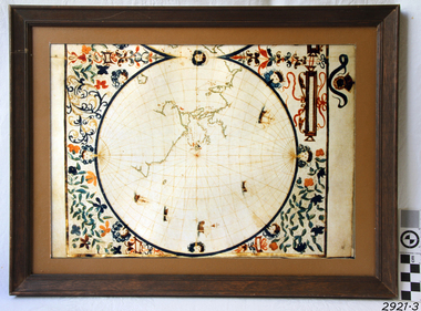 Flagstaff Hill Maritime Museum and Village
Maps
Maps (3) framed-Portuguese of Sumatra, Jave Le Grande and the Northern part of Australia - "Iaua la grande."flagstaff hill, warrnambool, shipwrecked-coast, shipwreck-coast, jave le grande, portuguese of sumatra, iaua la grande -
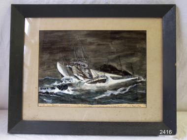 Flagstaff Hill Maritime Museum and Village
Print - Lithograph, Cruiser Melbourne Rescuing crew from the "Helen B Stirling" off Three Kings Islands New Zealand in January 1922, 1924
Lithography is a method of printing, originally based on the immiscibility of oil and water. The printing is from a stone or a metal plate with a smooth surface. It was invented in 1796 by the German author and actor Alois Senefelder and was initially used for musical scores and maps. There were two sailing ships with the name Helen B Sterling a six masted vessel and an earlier four masted Helen B Stirling that is the subject of the lithograph depicting the rescue of the crew and passengers by the Australian light Cruiser Melbourne in a gale off three Kings islands 55 kilometres Northwest of Cape Reinga New Zealand. This Helen B Sterling was built as a four mast wooden auxiliary screw Schooner, known as a wind jammer of 1608 tons. The vessel was formally known as the “Tacoma” and owned by the Washington Shipping Corporation based in Seattle USA in 1917. This original Helen B Sterling was caught in this storm and eventually sunk after being abandoned by the crew. The second generation relatives of those who were passengers at the time of the foundering advise that the storm was more like a cyclone. The Zeehan and Dundas Herald reported on January 26th 1922 that the abandoned vessel was still afloat and drifting towards the New Zealand coast. The Kalgoorie Miner newspaper also had an article reporting that on the 7th Feb 1922 the crew, captain, first mate and their families after being heroically rescued by the crew of the Australian light Cruiser Melbourne were arriving in Sydney today aboard the steamer the “Maheno” from New Zealand.Lithograph appears to be by an unknown artist A M Duffield produced in 1924. It is significant in that it depicts the rescuing of the passengers and crew of the schooner “Helen B Stirling”. At the time this was a significant event that made most Australian and New Zealand papers because of the involvement of the Australian cruiser “Melbourne”.Lithograph framed of cruiser Melbourne rescuing crew from Helen B Stirling off New Zealand coast. By A.M. Duffield."Australian Cruiser Melbourne Rescuing crew of (undetermined text _ _) Schooner Helen B Sterling of (Halifax Nth Canada Tons 1343 in a gale in the Pacific Ocean" (this last potion of text is incorrect see note sec this document) Lithograph signed bottom right hand corner in black "A M Duffield Nov 19th 1924"warrnambool, flagstaff-hill, flagstaff-hill-maritime-museum, maritime-museum, shipwreck-coast, flagstaff-hill-maritime-village, lithograph, a.m.duffield., helen b stirling, schooner, cape reinga new zealand, alois senefelder, cruiser melbourne, three kings islands -
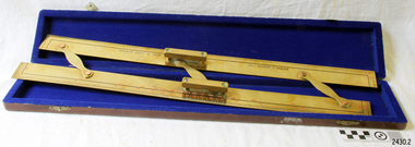 Flagstaff Hill Maritime Museum and Village
Parallel Rule, 1947-1950
Navigators use parallel rule with maps and charts for plotting a specific course on a chart. One long edge is used with the compass rose on the chart, aligning the centre of the rose with the desired direction around the edge of the rose. The compass bars are then ‘walked’ in and out across the map to the desired location so that lines can be plotted to represent the direction to be travelled. Kelvin Company History: The origins of the company lie in the highly successful and strictly informal relationship between William Thomson (1824-1907), Professor of Natural Philosophy at Glasgow University from 1846-1899 and James White, a Glasgow optical maker. James White (1824-1884) founded the firm of James White, an optical instrument maker in Glasgow in 1850 and was involved in supplying and mending apparatus for Thomson university laboratory and working with him on experimental constructions. White was declared bankrupt in August 1861 and released several months later. In 1870, White was largely responsible for equipping William Thomson laboratory in the new University premises at Gilmore hill. From 1876, he was producing accurate compasses for metal ships to Thomson design during this period and this became an important part of his business in the last years of his life. He was also involved in the production of sophisticated sounding machinery that Thomson had designed to address problems encountered laying cables at sea, helping to make possible the first transatlantic cable connection. At the same time, he continued to make a whole range of more conventional instruments such as telescopes, microscopes and surveying equipment. White's association with Thomson continued until he died. After his death, his business continued under the same name, being administered by Matthew Edwards until 1891 when he left to set up his own company. Thomson who became Sir William Thomson and then Baron Kelvin of Largs in 1892, continued to maintain his interest in the business after James White's death in 1884, raising most of the capital needed to construct and equip new workshops in Cambridge Street, Glasgow. At these premises, the company continued to make the compass Thomson had designed during the 1870s and to supply it in some quantity, especially to the Admiralty. At the same time, the firm became increasingly involved in the design, production and sale of electrical apparatus. In 1899, Lord Kelvin resigned from his University chair and became, in 1900, a director in the newly formed limited liability company Kelvin & James White Ltd which had acquired the business of James White. At the same time Kelvin's nephew, James Thomson Bottomley (1845-1926), joined the firm. In 1904, a London branch office was opened which by 1915 had become known as Kelvin, White & Hutton Ltd. Kelvin & James White Ltd underwent a further change of name in 1913, becoming Kelvin Bottomley & Baird Ltd. Hughes Company History: Henry Hughes & Sons were founded in 1838 in London as a maker of chronographic and scientific instruments. The firm was incorporated as “Henry Hughes & Sons Ltd” in 1903. In 1923, the company produced its first recording echo sounder and in 1935 a controlling interest in the company was acquired by S Smith & Son Ltd resulting in the development and production of marine and aircraft instruments. Following the London office's destruction in the Blitz of 1941, a collaboration was entered into with Kelvin, Bottomley & Baird Ltd resulting in the establishing “Marine Instruments Ltd”. Following the formal amalgamation of Kelvin, Bottomley & Baird Ltd and Henry Hughes & Sons Ltd in 1947 to form Kelvin & Hughes Ltd. Marine Instruments Ltd then acted as regional agents in the UK for Kelvin & Hughes Ltd who were essentially now a part of Smith's Industries Ltd founded in 1944 and the successors of S Smith & Son Ltd. Kelvin & Hughes Ltd went on to develop various marine radar and echo sounders supplying the Ministry of Transport, and later the Ministry of Defence. The firm was liquidated in 1966 but the name was continued as Kelvin Hughes, a division of the Smiths Group. In 2002, Kelvin Hughes continues to produce and develop marine instruments for commercial and military. This model parallel map ruler is a good example of the commercial diversity of navigational instruments made by Kelvin & Hughes after World War II. It was made in numbers for use by shipping after the second world war and is not particularly rare or significant for it's type. Also it was made no earlier than 1947 as the firms of Kelvin, Bottomley & Baird Ltd and Henry Hughes & Sons Ltd who took over from Smith & Sons were not amalgamated until 1947. It can therefor be assumed that this ruler was made during the company's transitional period to Kelvin & Hughes from Smith Industries Ltd.Brass parallel rule in wooden box with blue felt lining.Rule inscribed on front "Kelvin & Hughes Ltd" " Made in Great Britain"flagstaff hill, warrnambool, shipwrecked-coast, flagstaff-hill, flagstaff-hill-maritime-museum, maritime-museum, shipwreck-coast, flagstaff-hill-maritime-village, parallel rule, kelvin & hughes ltd, map ruler, plot direction, navigation, maps, echo sounder, kelvin & james white, lord kelvin, baron kelvin of largs, scientific instrument -
 Flagstaff Hill Maritime Museum and Village
Document - Navigation Chart, Admiralty Office, Lady Bay and Warrnambool Harbour, 03/04/1871
This Chart titled “Lady Bay and Warrnambool Harbour” was surveyed by Nav. Lieut. H.J. Stanley, of Britain's Royal Navy, in 1870 and printed in April 1871. The chart was made before the Warrnambool Breakwater was built (construction had begun in 1874 and was completed in 1890). The chart includes Directions for entering Lady Bay, Warrnambool Harbour. These are "Vessels entering Warrnambool Harbour must bring the Red Light in sight and steer in with it in line with the upper white Light bearing North, until the Green Light on the Jetty is opened, when steer towards it and anchor. The best anchorage is in 2 ¼ fms [fathoms)] of water, about a cable from ledge off Breakwater rock. Or where convenient, according to draught of water, only endeavouring to anchor as close as possible to Breakwater rock. It is not safe to enter or leave the Harbour in south westerly or Southerly gales.” This chart is significant for its strong connection to the maritime history of Warrnambool Harbour and Lady Bay, and eventually to the Warrnambool Breakwater. The Warrnambool Breakwater is registered as a place of significance on the Victorian Heritage Database (VHR H2024). A copy of the same chart was used to plan several submissions for future changes to the jetty and breakwater. The chart is a historical record of structures existing in 1870; the Warrnambool Jetties, Lady Bay, the leading lights (lighthouses), streets, roads, bridges and many buildings. It also shows the lay of the land and seabed.Canvas chart of Australia, South Coast, Victoria Title: Lady Bay and Warrnambool Harbour Surveyed by Nav. Lieut. H.J. Stanley, R.N., 1870. Magnet Variation, 1870 Published April 3, 1871, by the Admiralty, London. Directions for vessels entering Warrnambool Harbour are printed on the chart. The chart has a lacquer or seal over it.Top of chart has logo "HYDROGRAPHER OFFICE" "Price Eighteen Pence". "Engraved by Edward Weller" Along bottom of Chart: “London… Published at the Admiralty, 3rd April 1871, under the Superintendence of Rear Admiral G.H. Richards, F.R.S. Hydrographer, Corrections July 71” Bottom of chart “Australia South Coast Victoria Lady Bay and Warrnambool Harbour. 2494”flagstaff hill, warrnambool, chart of lady bay warrnambool 1870, warrnambool harbour, cartography, navigation, warrnambool breakwater, 1871, australia – south coast / victoria, lady bay, 1870, nav. lieut. h.j. stanley, r.n, directions for entering warrnambool harbour, hydrographer office, rear admiral g.h. richards, edward weller, port of warrnambool, flagstaff hill maritime museum & village, maritime museum, maritime village, shipwreck coast, map, chart, navigation chart, admiralty chart, breakwater, jetty, pier, vhr h2024 -
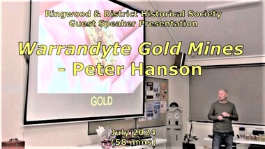 Ringwood and District Historical Society
Mixed media - Video, RDHS Guest Speaker Presentation - "Warrandyte Gold Mines" - Peter Hanson
Digitised video (2.73GB). Duration: 58 minutes. Recorded July, 2024. (Video is available for viewing at Ringwood & District Historical Society Archives by appointment)Guest Speaker, Peter Hanson grew up in Warrandyte surrounded by signs of gold mining activities including in his own back yard. In this presentation, Peter talks about the numerous diggings in the area, with images, maps and drawings of the mines, tunnels, shafts and structures above and below ground. -
 Ringwood and District Historical Society
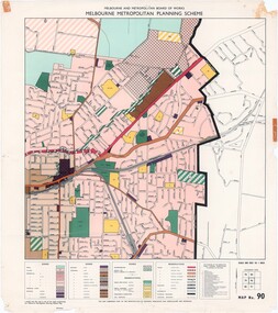
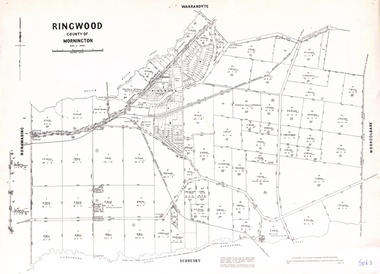
Map - Melbourne Metropolitan Planning Scheme, Municipality of Ringwood area - circa 1970
Colour-coded map marking proposed and existing business, industrial, transportation, public reservation, etc. planning zones within the City of Ringwood. Includes (undated) certification that this map is one of the maps constituting the Melbourne Metropolitan Planning Scheme Map.Scale: 800 feet to 1 inch. -
 Ringwood and District Historical Society
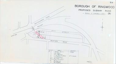
Map, Borough of Ringwood, Victoria - Proposed Subway Road - 1943
... Subway Road - 1943 Map ...Technical drawing by D.H. Oliver dated 22/9/43 showing residential lots affected by proposed road extending from Warrandyte Road railway underpass into Pitt Street and Bedford Road. Includes list of owners and occupiers of properties - Lot 4 Stanley Harris /R. Taylor, Lot 6 R.S. Sharp, Lot 7 William J. Wakeham, Lot 8 Janet R. Gibson /Mrs C. Burden, Lot 9 Mrs McClelland, Lot 10 part Mrs. Yetts, Lot 11 part 10 Church of Christ, Lot 54 Mrs Shwerkolt, Lot 55 Mrs Goodall.Scale: 2 chains = 1 inch. -
 Ringwood and District Historical Society
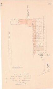
Map - Plan of Survey, Part of Crown Portion 12, Parish of Ringwood, Victoria - circa 1930
... Church and Falconers Grocery Shop on Whitehorse Road corner. Map ...Map of area bounded by Ringwood Street, Melbourne Street and Adelaide Street, showing details of Adelaide Street allotments and existing outbuildings. Certificate of Title numbers include Ringwood Street C/T 3418-553, C/T 3563-433, Adelaide Street C/T 7151-047, C/T 7038-465, C/T 7098-464, C/T 7098-465, C/T 3604-635, C/T 8066-900, C/T 3866-118, C/T 3609-728, and C/T Vol 3670 Fol 133992.Subsequent additional notations identifying 1971 closure of Melbourne Street North, and properties of Hone, Patendon, Pines Hosptial, Mail Office, Presbyterian Church and Falconers Grocery Shop on Whitehorse Road corner. -
 Ringwood and District Historical Society
Map, Proposed Subdivision - Hilltop Estate, Heathmont, Victoria - circa 1925
Plan of Part of Crown Allotments 16 & 18, Parish of Ringwood, County of Mornington. Subdivision includes Site for Heathmont Station, Heathmont Road, George Street, Lilian Street, Edith Street, Edna Street, Great Ryrie Street. Inset locality plan also shows nearby Electric Railway Estate and Heathmont Station Estate. L.H. Webber, Licensed Surveyor, 440 Little Collins Street, Melbourne. -
 Ringwood and District Historical Society
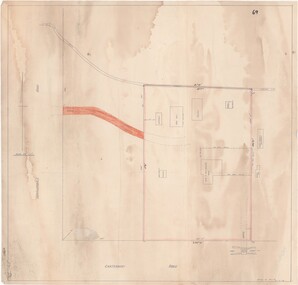
Map - Ringwood Animal Welfare Clinic, 1958 Land Survey Drawing, Ringwood, Victoria
Plan of driveway and property east of Heatherdale Road and Canterbury Road corner, with details of house, shed, bungalow, dog pen, kennels and enclosures.Survey by H.L.M. 31-7-58. Scale 20'=1" -
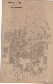 Ringwood and District Historical Society
Map, Borough of Ringwood, Victoria - c.1950s
A0-size (approx) linen-backed municipal engineer’s survey map of named streets and lot-numbered properties within Borough of Ringwood.Scale: 8 chains to 1 inch. -
 Ringwood and District Historical Society
Poster, Land Sale Advertisement - Pinemont Estate, Ringwood, Victoria - circa 1924
Map of residential allotments for sale, with terms of sale, summary of subdivision features and local services and facilities, and photographs of local street scene and lake (Loughnan's Lake - location not marked), Subdivision includes Wonga Road (later Loughnan's Road), Glenvale Road, Kubba Road, Felix Crescent, Summit Crescent, Pine Crescent, Aurum Crescent, Hygeia Parade, Panorama Avenue, Avalon Grove, Montalbo Road, Cielterre Avenue. Sole Agents T.M. Burke Pty Ltd, 340 Collins Street Melbourne Phones 6294, 6779. Map by S. Callanan, Licensed Surveyor, 107 Elizabeth Street Melbourne. Date of poster estimated from railway services information extract " ... 36 fast electric trains to Flinders Street daily ... proposed electrification to Croydon ..." . Timeline for electrification of Lilydale Line record indicates Box Hill to Ringwood January 1923, Ringwood to Croydon November 1924 (Source: History of Croydon - McGivern, Vol.1 p20). -
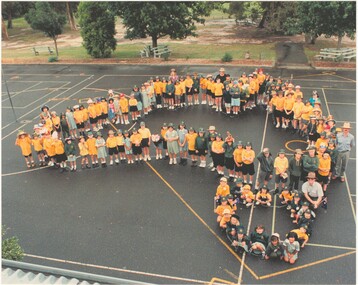 Ringwood and District Historical Society
Photograph, Southwood Primary School staff and student photo forming map of Australia outline (undated) - circa 1997-8
colour photoSOUTHWOOD Primary School students and staff -
 Ringwood and District Historical Society
Map - Public Land Sale by Thomas Ham, 2000 Acres for Sale - Crown Sections 20, 23, 24 - Ringwood, Victoria - 1855
Two 1850s surveyor's maps on cardboard backing showing area from Melbourne extending East beyond Bulleen and Nunawading. Detailed description of lots for sale and navigational directions to the property from Richmond by Thomas Ham, Victorian public servant, map maker, publisher, lithographer and original Ringwood land owner. Inset map enlarging area between Yarra River and Dandenong Creek, with southern boundary of allotments later forming part of Oban Road, North Ringwood.TRANSCRIPT: "This really valuable Property is now offered to the public for sale, in lots to suit purchasers at the Iow rate of £1 per Acre for 80 acres and upwards, and £1.10s per Acre for any smaller portion. Terms of payment Half Cash, Balance in 6 and 12 months, bearing 8 per cent interest. The Estate is well wooded with Gum, Cherry Tree and Stringy Bark, with Wattle in the valleys of the several creeks. Every lot is Staked and Trenched at the corners marked on the Plan thus - The Surveyor has carefully sub-divided the Property, in order to give every Farm a Creek for Water, Valley for Cultivation, and Hills for House and Grass Paddock. The ROADS have been very carefully laid out so as to give a firm, well drained, and nearly level road to each Homestead. Intending purchasers can readily find the property by the following directions, viz: Start from Richmond Bridge, at Hawthorne, then take the left-hand road to KEW. When at the "Woodman Inn", take the Cotham Road to the right, bearing due east, keep this Road, passing Trainor's "White Horse" Inn, and before you leave the fences, you will see calico bills (see margin) nailed to the Trees on the bush track leading to the Upper Yarra country, follow the Bills till you come to the SOUTH boundary line of the Property, which bears East and West (see Plan) where you will see Bills nailed up "THIS PROPERTY FOR SALE, etc." The Bills from Town lead direct to where Mr. Jull is erecting his Store, and arrangements have been made with him to show the lots to intending purchasers free of charge. At the respective corners of the lots the Bills are nailed up double, with numbers to denote the lot, and that the corner stake is adjacent. Any parties wishing to proceed to the property by way of BULLEEN will find Bills nailed on the Trees, commencing at the NEW INN, at "Wilson's Slip Rail." Keep this Track till you come to the Log Bridge, over the Deep Creek at Bloxhome's Paddock; go through the land now being cleared; keep the track over the hill till you come to an Iron House, you will then be on the property, which Iies to the North and East as per Plan. Follow the Bills till you come to Mr. Jull's Store, etc. etc. Further particulars can be had from the Agent for the Property. THOMAS HAM. " -
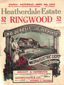 Ringwood and District Historical Society
Pamphlet - Land Auction Brochure, Heatherdale Estate, Ringwood, Victoria - 1919
Double sided leaflet advertising subdivision site, layout of streets and allotments, summary of local features and services and terms of sale. Inset photographs of local views and residence of F.W. Purches on the Estate.Auction Saturday September 6th, 1919. 52 Lots. Subdivision includes White Horse Road, Witt Street, Mitcham, Station Street (later Victory Street, Mitcham). (Railway Avenue marked on the map did not eventuate). Agents - Knight & Harwood, 315 Collins Street, Melbourne in conjunction with Godbehear & Co, Phone Ringwood 49, selling through their auctioneer - Sydney T. Haynes. Solicitor W.H. Peers, 395 Collins Street, Melbourne. -
 Ringwood and District Historical Society
Map - Parish of Ringwood, County of Mornington, Victoria, Original Land Owners
Laminated Parish map of Ringwood detailing original Land Owners' names, property locations and acreages. Details reproduced in 1957 by the Department of Lands and Survey, Melbourne, from original surveys of varying dates. -
 Phillip Island and District Historical Society Inc.
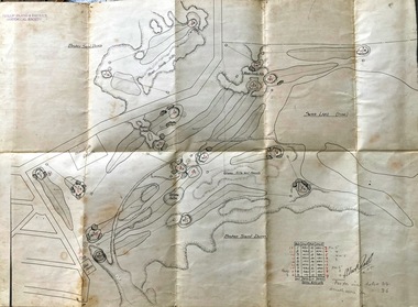
Map, Map of Summerland Golf Course, 15/12/1927
Summerlands Estate was created in the 1920s by A.K. T. Sampbell. It consisted of a housing estate, guest house and golf course. This area was acquired and all buildings, roads etc removed by the Victorian Government in the 1980s for a nature reserve for the penguins. This is believed to be the only time in the world when humans have been removed to benefit nature. HistoricalPurple leather covered fold out linen map with hand drawn diagram of the topography, layout of golf holes and club house Broken sand dunes, rough sandy hills, grassy hills and mounds, Swan Lake, Par for nine holes 34, Scratch score for nine holes 36, Drawn by A. Russell 12/12/1927summerland estate, summerlands golf course, a.k. t. sampbell, map, penguin reserve -
 Phillip Island and District Historical Society Inc.
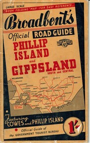
Booklet, Broadbent's Official Roadguide Phillip Island and Gippsland 45, c. 1945
Broadbent's was the official guide of the Government Tourist Bureau. Mr Roy Bain owned a secondhand shop on corner of Thompson Ave and Chapel Street, Cowes, currently a Japanese restaurant.HistoricalSmall orange, black and red booklet with black type containing maps and information of accommodation, businesses and tourist venues.Broadbent's Official Road Guide Phillip Island and Gippsland South and Central. Broadbent's Year of Issue 45.guesthouses, broadbent's guides, hislop newsagency, underdown strawberry farm, osterlund fishing trips, parry's butcher, athenia cafe, roy bain, broadway bakery, cowes camping ground, cowes main garage, beach park camp -
 Flagstaff Hill Maritime Museum and Village
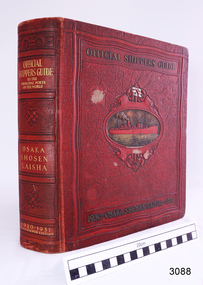
Book - Reference, M. Franklin Kline, Official Shippers Guide, 1930
This book has information about shipping companies and the world's ports. It was a handy guide for travellers of the time and included how and where to board ships going to various countries in 1930 & 1931. In effect, it was a reference work like a timetable for shippers and travellers alike.The book has maps depicting N.Y.K. shipping lines all over the world, indexes (including advertisers), and is thumb-indexed. This book is an official guide that supplies vast information for ships and shipping lines but also for tourists of the time. These types of reference works are keenly collected today.Official Shippers Guide reference book to the Principal Ports of the World, OSAKA SHOSEN KAISHA, 1930 – 1931, Seventeenth Edition, edited, compiled and designed by M. Franklin Kline. Large, hard covered, bound book with margin thumb tabs. Covers are dark red with gold lettering and embossed pattern. Centre of front cover has an oval image of a red steam ship on a gold sea. Above the ship is a white flag with a red emblem.flagstaff hill, warrnambool, flagstaff hill maritime museum, maritime museum, shipwreck coast, flagstaff hill maritime village, great ocean road, traveller's guide, shippers guide, osaka shosen kaishaguide, guide to world ports, m. franklin kline -
 Ringwood and District Historical Society
Entry Form - Walkathon, Wal Elms, Hon Chairman, Walkathon Committee, Maroondah Hospital Family Walkathon records of entry and progress - 1971-72, 1971
Form for recording the entry and progress of a person in a family walkathon for the Maroondah Hospital. Qty 2. A map of the route is shown on the card and there is provision for about 20 sponsors. +Additional Keywords: Elms, Wal (Hon Chairman) / McGrath, Keith (Hon Sec) / Gough, Mrs