Showing 31872 items
matching south
-
 Eltham District Historical Society Inc
Photograph - Digital Photograph, Alan King, Site of the Diamond Creek Gold Mine, 28 December 2007
The largest gold mine in the area originated from a find in 1862. The mine was closed January 20, 1915 when a fire destroyed nearly all the above ground plant. Published: Nillumbik Now and Then / Marguerite Marshall 2008; photographs Alan King with Marguerite Marshall.; p75 Beneath Mine Hill, as locals call it, runs a network of tunnels once of central importance to the fledgling township of Diamond Creek. These are relics of gold mines, which transformed early Diamond Creek.1 The tiny settlement of about 20 families soared to more than 200 because of gold. For around 50 years, from 1862, gold mining was Diamond Creek’s major source of employment. On September 7, 1854 The Argus newspaper reported a find of a four pound (1.8kg) gold nugget in Nillumbik (an early name for Diamond Creek). Exactly where, is not known.2 The largest mine in the district, the Diamond Creek Gold Mine, apparently originated from a find in 1862. It is said Joe and Dave Wilson were visiting former tailor then cook, Charles Orme, at the southern end of Fraser Street. Sitting on a stump outside the front gate on land belonging to Dr A. E. Phipps the Wilsons found a vein of gold-bearing quartz, which led to the discovery of four quartz reefs varying in width to eight inches (20cm), running north and south. A reef found at the foot of the hill opposite Challenger Street became the Union Mine. This reef was traced south to Allendale Road where a small mine began operations.3 Other smaller mines later operated as well. Dr Phipps immediately began to mine and also built the Diamond Reef Hotel as a boarding house for miners. But Charles Orme, who owned the land alongside, leased his mine to Dr Phipps probably because of insufficient funds and business skills. By mid 1865 the mine had produced 2530 ounces of gold – a 100% profit on the original outlay. Of course there were problems. When the local dam dried up a Blake pump was installed to draw water from the creek. The Union Mine operated under the Diamond Creek Gold Mine management except when disputes sometimes resulted in separate management. However disagreements had to be resolved as the Union Mine depended on Diamond Creek Gold Mine pumps to remove underground water from common reefs. In 1912 the main shaft of about 380 yards (350m) employed 200 men recovering an average of 5000 ounces (141.7kg) of gold a year. But not everyone did well out of gold. Records of failed mining companies in the Victorian Public Record Office, reveal that owner Dr Phipps leased his Right to others. Companies came and went over the next 40 years, most sponsored by Melbourne businessmen who sold shares to gullible locals and then became insolvent. Although there were some good profits, financial returns were haphazard until 1905. Some local residents, who were share holders in short- term companies, became well-known names in modern Diamond Creek such as Scott, Haley, Butler, Alder, Ryan, Wadeson, Reeves, Alston, Paul and Edwards. Gold mining was brought to a disastrous end on January 20, 1915 at 3 pm, when fire destroyed nearly all the above-ground plant. Fortunately no lives were lost. But reopening the mine was almost impossible because of the increasing depth of water in the main shaft. The closed mine destroyed the livelihood of 200 families and the debris took many years to clear.4 In 1946 the Diamond Creek Gold Mine was reopened by the Golden Hind Mining Company, but money ran out before the 600 feet (182.8m) or so of water could be removed. Gold remains in the mine but enormous capital would be needed to buy the land, equipment and to remove the water. Today 12 known sealed shafts along the ridge of the hills on private property extend west for around one kilometre from the corner of Fraser and Haley Streets, crossing Norma and Fyffe to Dering Streets. As recently as 1987, heavy rains revealed a former Union Mine shaft in the Georgiadis family Fyffe Street back yard.5 Allendale Mine, south of Allendale Road, is still open and one of the Union Mine’s main drives (horizontal excavation) remains unsealed, on the Creek Reserve.This collection of almost 130 photos about places and people within the Shire of Nillumbik, an urban and rural municipality in Melbourne's north, contributes to an understanding of the history of the Shire. Published in 2008 immediately prior to the Black Saturday bushfires of February 7, 2009, it documents sites that were impacted, and in some cases destroyed by the fires. It includes photographs taken especially for the publication, creating a unique time capsule representing the Shire in the early 21st century. It remains the most recent comprehenesive publication devoted to the Shire's history connecting local residents to the past. nillumbik now and then (marshall-king) collection, diamond creek, diamond creek mine, fraser street, gold mining, james cook drive, mine hill -
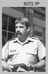 Bendigo Military Museum
Photograph - Printer Technicians and other RASvy personnel at the Army Survey Regiment, c1980s
These ten photographs were probably taken circa 1980s in Lithographic Squadron at the Army Survey Regiment, Fortuna, Bendigo. Most of the photos were taken on the shop floor in the Print Room.This is a set of photographs of Printer Technicians and other RASvy personnel in Lithographic Squadron, Army Survey Regiment, Bendigo c1980s. The photographs were printed on photographic paper and are part of the Army Survey Regiment’s Collection. The photographs were scanned at 300 dpi. .1) - Photo, black & white, c1980s, WO2 Steve Egan, Lithographic Squadron .2) - Photo, black & white, c1980s, WO2 Jeff Lynch, Lithographic Squadron .3) - Photo, colour, c1980s, SPR Peter Dillon, Lithographic Squadron .4) - Photo, black & white, c1980s, L to R: Peter Dillon, unidentified, Lithographic Squadron .5) - Photo, black & white, c1980s, L to R: SPR Colin Yeats, SPR Graeme Spong, CPL Peter Dillon, Lithographic Squadron .6) - Photo, black & white, c1980s, L to R: SPR Colin Yeats, WO2 Ralph Chant, Lithographic Squadron .7) - Photo, black & white, c1980s, L to R: Dale Hudson, Mark ‘Dogs’ Doherty, Lithographic Squadron .8) - Photo, black & white, c1980s, L to R: SGT Greg Rowe, WO1 Trevor Osborne, Dale Hudson, Lithographic Squadron .9) - Photo, black & white, c1980s, L to R: unidentified, SGT Kim Reynolds, Shane ‘Soupy’ Campbell, Lithographic Squadron .10) - Photo, colour, 1987, L to R: Jim Ash, Daryl South, Jeff Willey, unidentified, Lithographic Squadron.1P to .4P – not annotated .5P - annotated on front with ‘I AM BROKE, I’M NOT and me neither’, annotated on back with ‘Curly Larry Moe’ .6P to .9P – not annotated .10P – annotated with dateroyal australian survey corps, rasvy, army survey regiment, army svy regt, fortuna, asr, litho, printing -
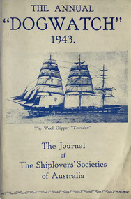 Mission to Seafarers Victoria
Journal (item) - Periodicals-Annual, Shiplovers' Society of Victoria, The Annual Dog Watch, 1943
This journal provides the reader with glimpses of the adventures and hardships of a seaman's life. Many of the stories are of sailing ships.First issue of the magazine published during the war Contributes to our knowledge of the importance of shipping and places on record those stories of the sea which would otherwise be lost.sailing ships, steamships, shipping, seafaring life, shiplovers' society of victoria, dog watch, ww2, hms jervis bay -
 Kiewa Valley Historical Society
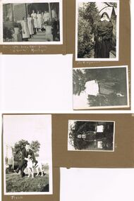
Photos - King Family Collection
The King family lived in Tawonga South where my older brother and sister went to school. We lived over the road from Wally Madison's farm. Later when a house became available, we moved into Valley Avenue, Mt Beauty. This is when I turned 5 and started my schooling. It was a long walk for a 5 year old as I remember. Then later we moved to 50 Lakeside Ave. I remember we loved living there as it was close to the school, footy ground and kindergarten. My father, Ted King, wad a carpenter and was involved in the building of many houses in Mt Beauty which was the home for the workers on the Kiewa Electric Scheme. So as they are part of the history of Mt Beauty I thought they may be useful to you as part of the history. The tennis photos, I vaguely remember Lou Hoad and Ken Rosewell giving exhibition matches in Mt Beauty. I may stand corrected on this, but I do remember my parents who were keen tennis players themselves were most excited at seeing these famous tennis players. As I was only 9 when we left Mt Beauty to live in Dimboola I still remember the shock of leaving a beautiful mountainous county side and arriving in a flat farming land next to a desert and seeing windmills One thing I do remember from school is, once a week (or fortnight) the teacher used to come around with a jar of little white pills, of which we were all to take. I really don't know what they were?? or for?? I also remember being taught to swim in the freezing cold river by a Mrs Smith who wore black bathers and wore her hair in a bun...... ...I am now in my 70s My father used to also carve intricate trays and jewellery boxes in his spare time. I think they were used for tennis trophies. by Diane Werner.x33 photos of small black and white photos of the Tawonga, Tawonga South and Mt Beauty - Photos not labelled but described as follows. See each photo for a possible label. A. Tawonga? B. Mt Beauty taken on the road to Bogong ? C. SEC Works D. Industrial buildings with mountains in the background E. Building site with wooden frame and 3 men F. Buildings with power poles G. Building site with lots of huts H. Buildings under construction I. Group of houses in the distance J. Group of houses in the distance K. Group of people in front of a building L. Group of 8 men sitting on timber planks, corrugated iron at back. M.& N. Building site with floor and upright timbers O. Mountain view with camp site in foreground P.& Q. Buiding site, several houses R.5 men at a building site S. portable building on trailer T & U. Mountain view V. Building site W. Group of men, car and mountains in background X. Cows Y. Pigs Z. 2 men standing next to cars. AA. Football players BB. Man painting a corrugated iron building CC. Football DD. Men in front of a building EE Buildings with mountains in background FF & GG Tennis payersHH & II. Electricity infrastructure -
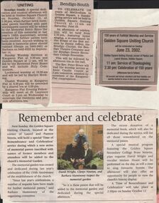 Bendigo Historical Society Inc.
Newspaper - BARBARA MAMOUNEY COLLECTION: 3 NEWSPAPER ITEMS,ONE INCLUDING AN IMAGE OF 3 PEOPLE
4 Newspaper items, one headed 'Bendigo South' To Celebrate 150 years of Methodism in Golden Square held at Golden Square Uniting Church at 11am on Saturday June 23; re-enactment by Jim Evans of the first sermon by Jimmy Jeffrey, the Bendigo Chorale , the Bendigo Theatre Company, Bendigo Senior Secondary College Ensemble. Followed by an afternoon tea in the hall. The Reverend Peter Hoare will lead the worship service at Anne Caudle Centre at 2pm tomorrow assisted by members of the Kangaroo Flat congregation; another headed 'Uniting' a special dedication and musical afternoon will be held at Golden Square Church on Sunday October 12 at 2.30pm when further brick pavers inscribed with past worshippers names will be added to the Memorial Entry. Since the creation of this memorial at last years 150th anniversary several requests have been received for further pavers to be. Anyone wishing to include a memorial paver should contact Glenys on 5443 9451 or Barbara on 5443 6323. Sunday Worship at Kangaroo Flat at 9.30am Golden Square at 11am will be led by the Reverend Peter Hoare and will include Holy Communion. Lockwood worship at 10.30 am and will be led by Marilyn Hocking. Cluster Worship at Kangaroo Flat at 6.30 pm will be preceded by a shared tea at 5.30 pm. Kangaroo Flat Evening Fellowship will meet at St Laurence Court at 2 pm on Wednesday to entertain the residents and provide afternoon tea.celebration of 150 years of methodism in golden square; golden square uniting church, laurel & panton sts; david wright, glenys newton and barbara mamouney; jim evans; jimmy jeffrey; bendigo chorale; bendigo theatre company; and bendigo senior secondary college; reverend peter hoare anne caudle centre; kangaroo flat congregation; glenys 5443 9541; barbara 5443 -
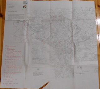 Bendigo Historical Society Inc.
Map - BENDIGO HISTORICAL SOCIETY COLLECTION: EAGLEHAWK MINE MAP
Base map Australian map grid of Eaglehawk area. Map has letter attached from the Department of Conservation, Forests and Lands, 22 March, 1990, addressed to Felicity Kingerlie, BHS, requesting information regarding the historic mining sites marked on the map. Sites marked are: A. Golden Age Mine, engine mountings present B. Johnson's No. 2 Mine, engine mountings, old boiler foundations C. Johnson's No. 1 Mine, mullock retaining wall made from sandstone, engine mountings, remains of old building demolished? D. Toma's Eucalyptus Factory, old boiler still there, boiler shed, chimney (remnants of) outlet drain, distilling vats, dam, remnant of winch. E. New Argus Mine,mullock heap F. New Moon Mines Dams (1) stone walls G. North Lightning Hill Mine, engine mountings, quartz retainer wall, Pascoe and Simmons open cuts and other open cuts here too H. New Prince of Wales Mine and Poppet Head I. Quarry site for stone, excavation (for miners cottages in Clarke Street) J. Lancashire open cut mine K. Virginia Hill (cynaide vats etc) L. South Prince of Wales mine, now capped and fenced M (possibly ) Catherine United Mine, engine mountings, battery mountings?bendigo, mining, eaglehawk mines -
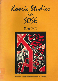 Victorian Aboriginal Corporation for Languages
Book, Catholic Education Commission of Victoria, Koorie studies in SOSE : years 7-10, 2001
Section 1. Notes on the use of this resource Section 2. Policy support statements. Aboriginal Studies Policy Statement of Victorian Aboriginal Education Association Incorporated (VAEAI) National Principles and Guidelines for Aboriginal Studies and Torres Strait Islander Studies, K-12 Principles for the Introduction of Aboriginal Perspectives in the Curriculum of the Catholic School (Catholic Education Commission of Victoria Policy 1.3, 1987) Section 3. Language, culture and viewpoint: issues of terminology Section 4. Units of work Unit 1. Koorie people of south-east Australia: a contemporary view Unit 2. On sacred ground Unit 3. Koorie life in the pre-contact era Unit 4. Mulla Meea-Baa Gnuenjall: a long time ago, and today Unit 5. The land we share: human stories in the environment Unit 6. Frontier wars Unit 7. Aboriginal mission stations and reserves in Victoria Unit 8. Land, law and indigenous Australians Section 5. Directory of indigenous organisations and affiliated groups/?agencies. National organisations Victorian organisations Catholic Education Commission of Victoria Indigenous Education personnel Organisations within regions of the Archdiocese of Melbourne Organisations within regions of the Ballarat Diocese Organisations within regions of the Sale Diocese Organisations within regions of the Sandhurst Diocese Cultural centres/?camps across Victoria.maps, b&w photographsvaeai, history, curriculum development, koorie studies, catholic education commission of victoria, secondary school education, -
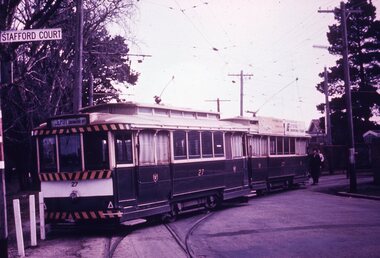 Ballarat Tramway Museum
Slide - 35mm slide/s - set of 7, Noel Simons, 1970's
Set of 7 transparencies taken undated (appear to be 1970 or 71) on PAKON mounts. Also possibly copy slides as quality is poorish. 1175.1 - No. 27 has derailed at Depot, across Wendouree Parade, and No. 33 appears to be about to try and tow it back on. Wendouree Parade totally blocked. Adjacent pole has tram stop sign and has "Stafford Court" street sign mounted on it. 1175.2 - No. 43 at corner of Drummond St. South and Dana Street, with destination Lydiard St. North. 1175.3 - No. 42 (Mt Pleasant) and 21 (Gardens via Sturt St. West) crossing at Gardens Loop. 1175.4 - No. 42 bound for Lydiard St. Nth at intersection with Macarthur St. Shows the retaining wall for the cutting on the east side of Lydiard St. Nth. 1175.5 - No. 43 at corner of Lydiard St and Sturt St., at city terminus showing "Special" and tram 35 adjacent to Post Office in Lydiard St. Nth. Photo shows the small tram stop pole at this location and Post Office building. 1175.6 - No. 39 and 26 and 27 at the Mt Pleasant terminus. Near closure as a bus stop sign has been positioned on the west side of the road. No. 39 showing destination of "Gardens via Sturt St. West" 1175.7 - Nos 21 and 34 crossing at the Grant St. loop in Barkly St. 21 has destination of Mt Pleasant, while 34, - Gardens via Sturt St. West"All information on typed small white labels, on the top of the slides using black ink. 1175.1 - "27 derailed and 33 at depot" 1175.2 - "43 at cnr Drummond & Dana Sts" 1175.3 - "21 and 42 Gardens Terminus" 1175.4 - "42 at cnr Macarthur & Lydiard" 1175.5 - "43 & 35 at Post Office" 1175.6 - "39, 26 and 27 at Mt Pleasant" 1175.7 - "21 & 34 at Grant St"tramways, trams, wendouree parade, depot, accidents, derailments, drummond st. sth, gardens loop, post office, mt pleasant, grant st., tram 21, tram 26, tram 27, tram 33, tram 35, tram 42, tram 43 -
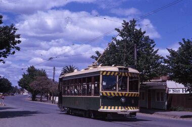 Ballarat Tramway Museum
Slide - 35mm slide/s, Noel Simons, 21/11/1962 12:00:00 AM
Set of 6 transparencies taken on 21/11/1962 on Kodak mounts. 1189.1 - Bendigo No.11 at Quarry Hill terminus. Photo taken looking in along the route. Tram has destination of North Bendigo. 1189.2 - No. 21 in Pall Mall bound for North Bendigo. Tram has roof ads for Mamouney's furniture and SEC. In the background are the National Bank building, Dad and Dave's Cafe and the Beehive Buildings and the London Pharmacy. 1189.3 - No. 2 in Mitchell St, just after crossing over railway bridge. Photo taken after tram has passed photographer. Has what appears to be an SEC road works crew in the background. Has destination of Quarry Hill. 1189.4 - No. 17 climbing Mitchell St. on the start of the single track section, just before crossing the railway bridge. Has destination of Quarry Hill and the large Maples building sign in the background. 1189.5 - as for 1189.4 but after tram has passed photographer. Has an Ilford film roof ad and an SEC roof ad. Railway bridge in the background. 1189.6 - No. 21 at Charing Cross with passengers boarding. Tram has destination of North Bendigo and roof ads for SEC 'Electric Cooking' and Sandhurst Milk. In background are the buildings on the south side of High St. Also has a SEC worker in white overalls sweeping the track.Information written on in black ink and date stamped on purple ink. 1189.1 - "Birney car No. 11 in High St. Bendigo at Golden Square terminus" 1189.2 - "No. 21 in Pall Mall Bendigo near Charing Cross" 1189.3 - "No. 2 in Mitchell St. Bendigo, just after crossing bridge over railway line (Quarry Hill route)" 1189.4 - "No. 17 in Mitchell St. Bendigo, climbing the hill the bridge over the railway line. (Quarry Hill route)" 1189.5 - "No. 17 in Mitchell St., Bendigo approaching bridge over Railway line (Quarry Hill route)" 1189.6 - "No. 21 at Charing Cross, Bendigo"tramways, trams, bendigo, golden square, pall mall, mitchell st., quarry hill, tram 2, tram 11, tram 17, tram 21 -
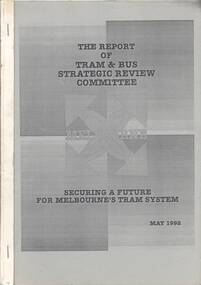 Ballarat Tramway Museum
Document - Report, Tram & Bus Strategic Review Committee, "The Report of Tram & Bus Strategic Review Committee - Securing a future for Melbourne's Tram System.", May. 1992
1302.1 - A4 size, 88 page report on Melbourne's tram and bus system produced by 'Tram & Bus Strategic Review Committee' in May 1992. Report printed on white paper, with blue covers, stapled on sides. Report examines cross linking of trams routes and many other recommendations regarding services, union awards, ticketing, opportunities for expansion, reliability, revenue impacts, driver only trams, workplace reform, staffing, revenue protection and tourism opportunities. Note the report has been mis-bound with pages out of order eg 2, 1, 4, 3, 6, 5 etc. Gives a series of recommendations, few of which were implemented in reality. 1302.2 - A4 size - approx. 200 page document with blue covers - appendix to the above report. List of appendices given in 1302.1. Appendix No. 1 - Left/right turn priority at intersections 2 - draft structural efficiency proposal 3 - selection and training procedures report 4 - absenteeism report 5 - cost study of W and Z class trams 6 - Trams in Melbourne - AGB Australia Consultants 7 - Proposed tram and bus depot - South Melbourne - Detailed evaluation 8 - Depot and Route vehicle composition 9 - Options and Feasibility study of Additional W class trams in Melbourne.trams, tramways, melbourne, routes, strategic reviews, tramway systems -
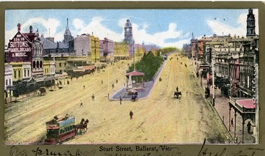 Ballarat Tramway Museum
Postcard, Sturt St. from top of the Nicholl and Allan Building, c1904
2437 - Printed colour postcard of the east end of Sturt St. from top of the Nicholl and Allan Building in Grenville St looking west. Has a horse tram leaving the Grenville St. terminus travelling up to Lydiard St. on the north side of Sturt St. Has the buildings on either side of Sturt St. in the view, including Suttons Music store. Titled "Sturt St Ballarat Vic" along the bottom edge. 2437.1 - On the bottom of the postcard is a two line hand written message. On rear of postcard is the address to a Miss C. Haurley of 4 Mortuary Road, South Shields England and two Victorian stamps - half penny (green) and one penny (red) stamps. Has been postmarked "North Melbourne Vic. Feb? 23 05" and over stamped "289" over the penny stamp. See images .1 and .2 2437.2 - On the bottom of the postcard is a single line hand written message. On the rear of postcard is the address to a Mr Frank Tucker, Glencairn, Park Avenue, Harrogate, England. Has two Victorian stamps, half penny (green) and one penny (red) stamps. Has been postmarked twice with the same stamp, "Ballarat East 16.01.04" or 16.11.04?? See images .3 and .4 See Reg Item 5103 for a black and photograph close up of the horse tram in the photo. trams, tramways, horse trams, sturt st, postcards, grenville st -
 Ballarat Tramway Museum
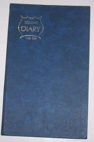
Administrative record - Log book, Diary, Collins Bros, 1970
Yields information about the track maintenance activities of the track gang in Ballarat, the work they did, notes, names and other information.Collins Australian Diary, No. 324 printed by Collins Bros, dark blue card covers, sewn sections with ruled sheets providing a diary for 1971, one week per double page. Has "useful information" sheets at from the diary. Used by the SEC Ballarat track gang to record their daily work, leave, welding, track cleaning, truck driver etc. Names of gang often mentioned in the diary undertaking specific jobs and when on leave. Last day work recorded - 24/9/1072. Loose contents Inside front cover Workshop requisition to fill pot holes and note re rail requirements for Daylesford and Hamilton. Clip to page with metal paper clip. 29/8/1971 - note re account numbers and on rear of a pink requisition form - work list for gang. 12/9/1971 - Workshop Requisition form - green dated 6/5/1971 Inside rear cover Circular for a Male Cleaner in Traralgon Workshop Requisition for work at the Zone substation - Ballarat South Circular to authorised drivers re used of defective vehicles. Has W. Vermeend name typed in top left hand corner. SEC Long Service Regulations circular - has name D.Wiseman handwritten in top right hand corner. 5 sheets of blue carbon paper.tram, trams, sec, ballarat, depot, trackwork -
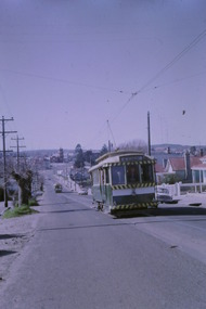
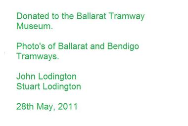 Ballarat Tramway Museum
Photograph - Digital image Set of 11, Stuart Loddington, 10 images of Ballarat trams prior to closure, 1971
Yields information about Ballarat Tramways and trams prior to the closure of the tramway system.Set of 11 digital images, comprising 1 donation text image and 10 images of Ballarat trams prior to closure, scanned from original slides by Stuart Lodington, 1971 prior to closure of the system. .1 - Donation text slide. .2 - No. 26 southbound in Lydiard St North, with the Ballarat Railway Station level crossing gates in the background. .3 - No. 27 and 30 crossing at Bell St Loop, Skipton St. (see also btm4976i4) .4 - No. 17 Wendouree Parade, near Gardens Loop .5 - Single truck tram at Victoria St terminus, taken from the west side of the Buninyong Rail line bridge, with CRB Roadwork sign, Eureka Caravan Park and Meagher Hotel in the background, possibly No. 11, see entry for .10 .6 - No. 12 and 30 crossing at the Urquhart St Loop, Drummond St South. .7 - No. 12 westbound in Sturt St, with Grenville St in the background. .8 - No. 17 at Gardens Loop with the Trolley pole being reversed. .9 - No. 30, Lydiard St North with Reid's Palace building in the background. .10 - No. 11 passing over the Buninyong rail line bridge, with Gardens via Sturt St West and a Twin Lakes sign. Has a number of children alongside the driver. .11 - No. 21 heading northbound in Wendouree Parade, Gardens, just to the north of the now BTM depot junction.trams, tramways, ballarat, level crossings, buninyong railway, lydiard st north, bell st, victoria st, wendouree parade, gardens, drummond st, sturt st, tram 26, tram 27, tram 30, tram 17, tram 12, tram 21, tram 11 -
 Ballarat Tramway Museum
Photograph - Digital image Set of 10, Tony Smith, 5/09/1971 12:00:00 AM
Yields information about Ballarat Tramways and trams prior to the closure of the tramway system.Set of 10 digital images of Ballarat trams prior to closure, scanned from original slides by Tony Smith, 1971 prior to closure of the system. This set of slides, possibly on the last weekend of Mt Pleasant services - closure took place on 5/9/1971. .1 - 13 outbound in Barkly St, Mt Pleasant - with another single trucker and the Ballarat Fire Station in the background. .2 - Bogie tram and single trucker at Grant St Loop. Has the Mobile service station on the right hand side. Note the family sitting on the steps of a house on the left side watching proceedings. .3 - 14 (Mt Pleasant) and 39 ditto. .4 - 27? and 39 crossing at the Morrison St loop. .5 - 14 and another single trucker at Mt Pleasant terminus. Has the corner store in the background with adverts for Robur Tea, Womens Weekly and Coca Cola. .6 - 39 and two single truckers at the Mt Pleasant terminus. .7 - View looking south along Ripon St from Mair St, with power station buildings on the right hand side. Shows the power distribution poles on the street. .8 - Scrubber tram on 0 road with tennis court alongside. .9 - 40 running special in Wendouree Parade, near the Haddon St intersection. .10 - 40 turning from Macarthur St into Drummond St Nth.trams, tramways, mt pleasant, barkly st, grant st, victoria park, sturt st west, ripon st, view st, depot, wendouree parade, drummond st nth, macarthur st, closure, tram 14, tram 39, tram 13, tram 26, tram scrubber, 40 -
 Bendigo Historical Society Inc.
Photograph - HILDA HILL COLLECTION: BLACK AND WHITE PHOTOS, 1922
Series of Black & White Images depicting life for the Hill Family and Friends During 1922 Post War Boom. Total 5 Photos. Ladies Day Out: Alma, Kitty, Lorna Claire & Eileen, all the ladies are dressed in white, lady at front wears dark stockings others are wearing white stockings and shoes, first two are standing on the steps and the others are on the verandah, two stone pillars with garden pots on them, Window of house to the left and curtains hanging inside, 'The Ranche' March 1922. (Aunt Mabel) Sister M. Alphonsus, dressed in dark habit with rosary hanging from her waist, arms crossed, standing in archway covered with vine, to right a spire can be seen. Uncle Percy in South America with Fox Terrier, holding a gun in his left hand, garden setting with palm trees. Frank, dressed in black suit white shirt and dark tie with his hands around a Hound Dog enjoying some R&R. Ken with his tennis racquet, in his dark coloured uniform white shirt and dark tie, standing between two chairs holding a tennis racquet and ball, both chairs have a white cloth backing, left chair with object on seat and large vase on the ground, trellis to the right, weatherboard to the left and shrub.Hilda Hill Personal Collectionaustralia, history, post war life -
 Kew Historical Society Inc
Plan, Melbourne & Metropolitan Board of Works : Borough of Kew : Detail Plan No.1581, 1904
The Melbourne and Metropolitan Board of Works (MMBW) plans were produced from the 1890s to the 1950s. They were crucial to the design and development of Melbourne's sewerage and drainage system. The plans, at a scale of 40 feet to 1 inch (1:480), provide a detailed historical record of Melbourne streetscapes and environmental features. Each plan covers one or two street blocks (roughly six streets), showing details of buildings, including garden layouts and ownership boundaries, and features such as laneways, drains, bridges, parks, municipal boundaries and other prominent landmarks as they existed at the time each plan was produced. (Source: State Library of Victoria)This plan forms part of a large group of MMBW plans and maps that was donated to the Society by the Mr Poulter, City Engineer of the City of Kew in 1989. Within this collection, thirty-five hand-coloured plans, backed with linen, are of statewide significance as they include annotations that provide details of construction materials used in buildings in the first decade of the 20th century as well as additional information about land ownership and usage. The copies in the Public Record Office Victoria and the State Library of Victoria are monochrome versions which do not denote building materials so that the maps in this collection are invaluable and unique tools for researchers and heritage consultants. A number of the plans are not held in the collection of the State Library of Victoria so they have the additional attribute of rarity.Original survey plan, issued by the MMBW to a contractor with responsibility for constructing sewers in the area identified on the plan within the Borough of Kew. The plan was at some stage hand-coloured, possibly by the contractor, but more likely by officers working in the Engineering Department of the Borough and later Town, then City of Kew. The hand-coloured sections of buildings on the plan were used to denote masonry or brick constructions (pink), weatherboard constructions (yellow), and public buildings (grey). The streets and built structures in this plan were surveyed in 1903 and released to contractors in 1904. In addition to the designation of building types by colour, the plan includes detailed descriptions of land use and ownership. While many buildings remain from this period, a number of the buildings represented have been demolished including the original Kew Town Hall, and the Congregational and Roman Catholic churches in Walpole Street. While the mansion ‘Illapa’ in Princess Street is still extant – now part of ‘Rylands’ – the neighbouring mansion ‘Elsmere’ was demolished some decades ago. Rivalling Illapa and Elsmere in size were two mansions in Walpole Street, one named on the plan as ‘Gnarlbine’. Over time, Kew Junction and the south side of High Street have been reconfigured and widened, so that the commercial buildings on the corner of Princess and High Street no longer exist. A surprising feature of this part of central Kew to the northwest of Kew Junction is the amount of vacant land. In a number of cases, this land is noted by the contractor as used for vegetable gardens.melbourne and metropolitan board of works, detail plans, maps - borough of kew, mmbw 1581, cartography -
 Kew Historical Society Inc
Plan, Melbourne and Metropolitan Board of Works, Melbourne & Metropolitan Board of Works : Borough of Kew : Detail Plan No.1294 & 1295, 1904
The Melbourne and Metropolitan Board of Works (MMBW) plans were produced from the 1890s to the 1950s. They were crucial to the design and development of Melbourne's sewerage and drainage system. The plans, at a scale of 40 feet to 1 inch (1:480), provide a detailed historical record of Melbourne streetscapes and environmental features. Each plan covers one or two street blocks (roughly six streets), showing details of buildings, including garden layouts and ownership boundaries, and features such as laneways, drains, bridges, parks, municipal boundaries and other prominent landmarks as they existed at the time each plan was produced. (Source: State Library of Victoria). This plan forms part of a large group of MMBW plans and maps that was donated to the Society by the Mr Poulter, City Engineer of the City of Kew in 1989. Within this collection, thirty-five hand-coloured plans, backed with linen, are of statewide significance as they include annotations that provide details of construction materials used in buildings in the first decade of the 20th century as well as additional information about land ownership and usage. The copies in the Public Record Office Victoria and the State Library of Victoria are monochrome versions which do not denote building materials so that the maps in this collection are invaluable and unique tools for researchers and heritage consultants. A number of the plans are not held in the collection of the State Library of Victoria so they have the additional attribute of rarity.Original survey plan, issued by the MMBW to a contractor with responsibility for constructing sewers in the area identified on the plan within the Borough of Kew. The plan was at some stage hand-coloured, possibly by the contractor, but more likely by officers working in the Engineering Department of the Borough and later Town, then City of Kew. The hand-coloured sections of buildings on the plan were used to denote masonry or brick constructions (pink), weatherboard constructions (yellow), and public buildings (grey).The streets and built structures in MMBW Detail Plan 1294 & 1295 were surveyed in 1903 and released to contractors in 1904. This plan is one of two in the collection where the lithographers amalgamated two separate plans. Both plans include sections of Studley Park. Dominating the south and west corners of Kew Junction are the Clifton and Kew Hotels. The Kew Hotel, owned by Patrick O’Shaughnessy was one of the oldest in Kew. MMBW plans were amended over time to take account of new subdivisions such as that which created Merrion Place. Of the four mansions shown in Studley Park Road, three remain – ‘Field Place’, the home of Frances Henty, ‘Leaghur’ and ‘Darley’. ‘Byram’ (later ‘Goathland’, then ‘Tara Hall’) was an architectural marvel. Designed in 1888 by E.G. Kilburn for the paper magnate George Ramsden, it was demolished in 1960. While an earlier sale of the southern section of Byram had created Tara Avenue in 1927, the demolition of the house in 1960 enabled the extension of Tara Avenue northward.melbourne and metropolitan board of works, detail plans, mmbw 1294, mmbw 1295, cartography -
 Kew Historical Society Inc
Plan, Melbourne & Metropolitan Board of Works : Borough of Kew : Detail Plan No.1571, 1904
The Melbourne and Metropolitan Board of Works (MMBW) plans were produced from the 1890s to the 1950s. They were crucial to the design and development of Melbourne's sewerage and drainage system. The plans, at a scale of 40 feet to 1 inch (1:480), provide a detailed historical record of Melbourne streetscapes and environmental features. Each plan covers one or two street blocks (roughly six streets), showing details of buildings, including garden layouts and ownership boundaries, and features such as laneways, drains, bridges, parks, municipal boundaries and other prominent landmarks as they existed at the time each plan was produced. (Source: State Library of Victoria)This plan forms part of a large group of MMBW plans and maps that was donated to the Society by the Mr Poulter, City Engineer of the City of Kew in 1989. Within this collection, thirty-five hand-coloured plans, backed with linen, are of statewide significance as they include annotations that provide details of construction materials used in buildings in the first decade of the 20th century as well as additional information about land ownership and usage. The copies in the Public Record Office Victoria and the State Library of Victoria are monochrome versions which do not denote building materials so that the maps in this collection are invaluable and unique tools for researchers and heritage consultants. A number of the plans are not held in the collection of the State Library of Victoria so they have the additional attribute of rarity.Digital copy of the original survey plan, issued by the MMBW to a contractor with responsibility for constructing sewers in the area identified on the plan within the Borough of Kew. The plan was at some stage hand-coloured, possibly by the contractor, but more likely by officers working in the Engineering Department of the Borough and later Town, then City of Kew. The hand-coloured sections of buildings on the plan were used to denote masonry or brick constructions (pink), weatherboard constructions (yellow), and public buildings (grey). This plan is part of a large and historically significant group of MMBW plans and maps that was donated to the Society by the Mr Poulter, City Engineer of the City of Kew in 1989. When the contracts were let for surveyors to identify and record the extant houses and landscapes within an area for the Board of Works, the contracts were let at separate times, hence the anomaly where two copies of Plan No.1571 exist in our collection. The first of these plans identifies the building materials used in houses bordering Fitzwilliam Street, Edgevale Road, May Street, Malin Street, Davis Street and Wellington Street. The cut off point for the survey was the south side of Wellington Street. By 1903 when the survey was undertaken many of the sites were already built on, particularly those facing Edgevale Road. The plan identifies the preponderance of weatherboard houses in the area. The other version of the plan identifies the buildings between Wellington Street and Cotham Road.melbourne and metropolitan board of works, detail plans, mmbw 1571, cartography -
 Bacchus Marsh & District Historical Society
Photograph, Woolpack Stables Bacchus Marsh 1883
This image is one of a series of photographs taken by Melbourne based photographers Stevenson and McNicoll who visited Bacchus Marsh and its nearby districts between September and November 1883. James Elijah Crook settled in Bacchus Marsh in 1841 and soon after held a licence for a lodging house on the Portland Road. In about 1845, he built the first Woolpack Inn, a slab building of eight rooms. This was replaced in 1850 with a “stately country villa” of brick and stone. The stables were also built in 1850 to accommodate twenty horses. In 1851, Crook established a coach service to the goldfields. After being in use as a Court of Petty Sessions, the Woolpack Inn lost its licence and closed in 1862. After this date, Crook took an interest in horse-breeding and continued to use the stables for his horses. His most notable success was with his horse, Saladin, which won the Australia Cup in 1872, after two exciting dead-heats with The Flying Dutchman. James Elijah Crook died in 1889. The Woolpack Inn and Stables were sold and then used as a hay and corn store. In 1910 the site was leased for use as an abattoir. The Woolpack Inn was demolished in 1931. The site is still in use as an abattoir. Little remains of the original stables.Small sepia 'carte de viste' style unframed photograph on card with gold border framing photograph. Housed in the Jeremeas Family Album which contains photographs of Bacchus Marsh and District in 1883 by the photographers Stevenson and McNicoll. The photo is of a gable-roofed commercial stables with shingled roofing, and white-washed render to the walls, standing in a large cleared yard. There is a skillion extension to the south-west corner. On the front (northern) wall can be seen a door and three windows, two large and one small paned window in the centre. The eastern window is paned, while the western window has louvres and a pull-out blind. Three S shaped stays can be seen on the northern wall. Along the western wall are two more windows and doors. A mound of hay lies at the north-western corner. Standing at the front of the stables is a group of five men and two boys, one holding a large dog. Four of the men are dressed in workman’s clothing and some are holding tools of their trade. The man at the back is wearing more formal clothes and has distanced himself from the workmen. The pole against which one of the workmen is leaning appears to have damage along one side. This pole may have been used as a hitching post as there is a footrest installed lower down to make mounting easier. Printed On the front: Stevenson & McNicoll. Photo. 108 Elizabeth St. Melbourne. COPIES CAN BE OBTAINED AT ANY TIME. On the back: LIGHT & TRUTH inscribed on a banner surmounted by a representation of the rising sun. Copies of this Portrait can be had at any time by sending the Name and Post Office Money Order or Stamps for the amount of order to STEVENSON & McNICOLL LATE BENSON & STEVENSON, Photographers. 108 Elizabeth Street, MELBOURNE. stevenson and mcnicoll 1883 photographs of bacchus marsh and district -
 Bendigo Historical Society Inc.
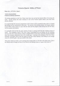
Document - DRAINAGE PROBLEMS - VICTORIA QUARTZ INFLUX OF WATER
Handwritten copy of a report in the Bendigo Advertiser 12/7/1910 Page 2. New Chum Mines. Progress of Bailing Operations. The bailing operations at the New Chum mines have not yet had the desired effect of lowering the water. On the contrary the water continues to rise in the Victoria Quartz which is the mine most directly affected. It is expected that the necessary preparations at the Lazarus will be completed today when it is hoped that bailing will be commenced at that mine. The success of the bailing scheme will largely depend on the efforts of the Lazarus to cope with the water and the progress made during the next few days will be awaited with interest. It is generally believed that the great volume of water is coming north from the southern group of mines. The companies south of the New Chum Consolidated are not bailing, and the pumping service at the New Chum Railway which is installed down to the 550 ft. level has not been operated since that company abandoned work a few months ago. A perusal of the statistics of the New Chum Drainage Association shows that the pumps at the New Chum Railway were lifting on anaverage close on 1,000,000 galls of water per month in the winter. That great volume of water is now pouring from storage dams at 550 feet to the deep levels, and in the natural order of things will have to be lifted by the tanking system in vogue at the mines N.' Document from Albert Richardson Collection of mining history.document, gold, drainage problems, new chum drainage association, victoria quartz influx of water, bendigo advertiser 12/7/1910 page 2, victoria quartz, lazarus, new chum consolidated, new chum railway, new chum drainage association -
 Melbourne Tram Museum
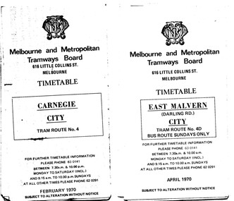
Ephemera - Timetable/s, Melbourne & Metropolitan Tramways Board (MMTB), "MMTB Tram Timetables", 1970
Set of 12 MMTB Tram timetables, folded sheets, 10 sections, providing timetables for specific routes, day of week giving information on tram times at specific time points, route map, sections and fares and organisation address - 616 Little Collins St. Melbourne. .1 - Route 4 - Carnegie - City - Feb. 1970. .2 - City Route 4D - East Malvern - April 1970 - notes a bus route on Sundays only .3 - Routes 55 and 56 - West Coburg - City via Domain Road and William St - Sept. 1970 .4 - Route 65 and 64 - East Brighton - City - April 1970 .5 - Route 1, 2, 15 and 16, St Kilda Beach, South Melbourne Beach and City - March 1970. .6 - Route 5 - Malvern Burke Road - City - April 1970 .7 - Routes 48 and 74 - North Balwyn - Burwood - City September 1970 .8 - Route 59 - Essendon - city - July 1970 .9 - Routes 88 and 96 - East Preston - East Brunswick - City - March 1970 .10 - Route 82 - Footscray - Moonee Ponds - Feb 1970 .11 - Routes 48 and 74 - North Balwyn - Burwood - City September 1970 - Saturdays and Sundays, printed on pink paper. .12 - Routes 88 and 96 - East Preston - East Brunswick - City - March 1970 - Saturdays and Sundays, printed on pink paper.trams, tramways, mmtb, timetables, melbourne, fares, route 4, route 4d, route 55, route 56, route 64, route 65, route 1, route 2, route 15, route 16, st kilda beach, carnegie, east malvern, west coburg, east brighton, south melbourne beach, route 5, route 48, route 74, route 88, route 59, route 96, route 82 -
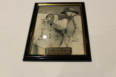 Dandenong/Cranbourne RSL Sub Branch
Photograph - Framed photo, Unknown
WWII Historical significance with some information of the Dandenong area.Black and white framed photo of 408537 Sgt R.R.E. Swords 23 Sep 1912 - 21 Jan 1943. This photograph is a tribute to the late Robert Richard Falkiner Swords. 'Bob' as he was known to his friends and most townsfolk of Dandenong and it's people. His older brother James, served in the First World War and later was a founding member of the Dandenong RSL Sub-Branch, formed in 1919, was its second President and also served a term as Honorary Secretary and Treasurer. James was the Editor of Dandenong's first newspaper, the Dandenong Advertiser. 'Bob' Swords was also a member of the Dandenong Advertiser newspaper and was a driving force in Dandenong getting it's own Hospital. For many years his photo hung over the entrance to the old building, which was demolished some years back. Regrettably this photo was lost. Bob enlisted into the Royal Australian Air Force to train as a pilot on 26 April 1941 and after initial training embarked to Southern Rhodesia. After completion of initial flight training he then moved to England for advanced training, prior to postings onto an OTU. He was tragically killed during this phase of training on 21 January 1943. The gentleman with in this photo is believed to be his South African Flying Instructor 'Panda' Watkins. His grave in England has a lovely headstone and the inscription: 'Service Above Self'. (As advised by Robert Richard Kudyba OAM).Brass plaque stating 4085537 Sgt R.R.F. Swords 23 Sept 1912 - 21 Jan 1943. -
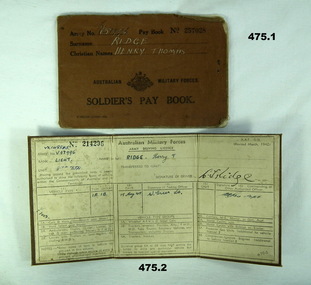 Bendigo Military Museum
Financial record - PAY BOOKS, ADMINISTRATIVE, DOCUMENTS WW2, 1) 1941 - 1942 .2) 1915-1944 .3) 26.2.1941 .4)20.10.1944 ? .5) 10.3.1944? .6) 2.5.1942? .7)? .8) 30.4.1942 .9) 7.5.1942
Henry Thomas Ridge initially enlisted in September 1934 No V57996, 8th Australian Infantry Battalion CMF. He rose to Sergeant then qualified as a Lieutenant on 8.10.41. He was stationed in Darwin during the bombing 19th Feb 1941. He was discharged and the re enlisted as VX148845 AIF on 9.3.44. He served overseas and was discharged 29.7.46 in 8MD Papua. Refer 473P.1) Pay book No 257028, brown covers re H.T Ridge. .2) Drivers Licence No 214206, Army issue, brown fabric covers, folds in three re H.T. Ridge Lieut. .3) Drivers Licence No 592440,civilian, yellowish paper, red, blue, black writing re H.T. Ridge. Feb 29-1941. .4) Army "Final Statement account," form W.F.88 re VX149945 Ridge HT, 20.10.44. Paper, black and white, stamped 21 october 1944. .5) Typed note re Lieut H. Ridge, yellowed paper dated 10.3.44, red lettering at top of page " CUTSA New South Wales". .6) Letter, dated 2.5.1942 to Mrs E. Ridge re H. Ridge "Seriously ill with appendicectomy.", letter yellowed. .7) Cardboard , yellowed, typed and hand written re brief description V57996 and VX148845 H.T. Ridge, military and medical history. .8) Telegram Re " V57996 H.T. Ridge seriously ill 30th April." Double sided, front Blue with message, rear red, stamped 1 May 1942. .9) Telegram re " V57996 H.T Ridge removed from ill list 7th May 1942, double sided, front blue with message, rear red, stamped 18th may 1942. .10) Pay book No 195734, yellow covers re H.T Ridge.documents - licences / letters, communication - telegraphic, photography - photographs -
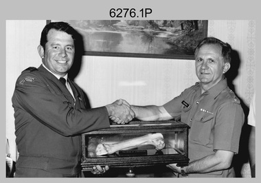 Bendigo Military Museum
Photograph - Bones Day - Army Survey Regiment, Bendigo versus RAAF School of Radio, Laverton, 1984, 1985 and 1988
These five photographs were taken at Bones Day, an annual sports competition between the Army Survey Regiment and the RAAF School of Radio in November 1984, 1985, and 1988. The two units took turns each year to host the event. The day competition usually comprised basketball, cross country, golf, sailing, squash, softball, tennis, touch football, rifle shooting, tug-of-war and volleyball. The “big bone” trophy comprising a large bone from a beast housed inside a wooden framed glass case, was awarded to the winner of the day competition. The evening competition often included darts, carpet bowls, hookey, quoits and billiards/snooker. The “little bone” (a mounted chicken bone) was the consolation trophy awarded to the winner of the evening competition. The “O.H.A.R.A Rock” seen in photo 6276.2P was awarded to PTE Zahra for the lowest score in rifle shooting. He had to lug it with him for the rest of the evening. The 3-hour bus trip for the visiting unit on their return was typically very raucous. The history of the Bones Day competition is best described in the booklet titled - Bones of Contention Souvenir Program. 1965. Refer to Item 6267. Photo 6276.1P is also published with item 6585.41P.This collection of five photographs was taken at Bones Day, an annual sports competition between the Army Survey Regiment and the RAAF School of Radio, at Bendigo and Laverton respectively in November 1984, 1985, and 1988. The photographs were printed on photographic paper and are part of the Army Survey Regiment’s Collection. The photographs were scanned at 300 dpi. .1) - Photo, black & white, 14th November 1984, RAAF CO WGCDR McCarthy presents ‘the Big Bone’ to Army’s CO LTCOL Jorge Gruszka. .2) - Photo, black & white, 13th November 1985, Trophy presentations L to R: MAJ Daryl Hockings CSM, PTE JB Zahra, unidentified RAAF officer. .3) - Photo, black & white, 13th November 1985, tug-of-war L to R: Peter Lefel, Kerron South, Barry Hogan, DB Zahra, unidentified (x2), Guenther Ebenwaldner, Steve Burke, Mal Paterson. .4) - Photo, colour, 1988, at Bendigo, tug-of-war L to R: Jodi Bowman, unidentified, Frank Savy, Barry Hogan, unidentified (x2), Graeme Spong, unidentified (x2), Mick Duggan, unidentified, Dave Lambton-Young, unidentified (x2). .5) - Photo, colour, 1988, at Bendigo, tug-of-war L to R: Mick Duggan, Dave Lambton-Young, unidentified (x3), Frank Savy (with sign), unidentified, Barry Hogan, unidentified, Graeme Spong, unidentified (x3)..1P to .7P – No personnel are identified. The date is stamped on the back of photos .1P to .3P.royal australian survey corps, rasvy, army survey regiment, army svy regt, fortuna, asr, raaf school of radio, bones day -
 Old Castlemaine Schoolboys Association Inc.
Document, Circular 1937
Dear old boy, the 24th annual reunion will be held in the town hall, Castlemaine, on Saturday ninth October, 1937 at 8 PM. You are earnestly invited to attend. And your subscription and tickets for reunion – the annual subscription 2/6 is now due. Members are urged to pay on before the night of meeting. Enclosed please find ticket (8/6) for the reunion. Change of address – members are asked to notify change of address age limit – the age of joining members is now 30 years. Extension of radius- the radius for membership is 7 miles. Members are urged to advise all of these to join and make the association one of the strongest in the state. Please try and secure new members. honor boards – 14 schools in the Castlemaine District have been presented with honour boards they are as follows – Fryerstown, Campbell's Creek, Chewton, Guildford, South Castlemaine, North Castlemaine, Woodbrook, Faraday, Elphinstone, Barkers Creek, Harcourt, Winters flat, St Mary's, Yapeen. School prize endowment – at the 1935 reunion -
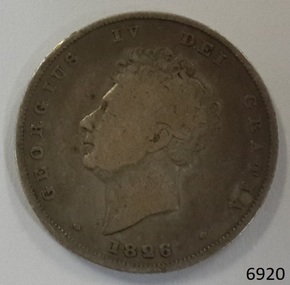 Flagstaff Hill Maritime Museum and Village
Currency - Coin, 1826
This Great Britain shilling is dated 1826. There were over 6 million of these coins minted during the reign of King George IV, 1820-1830 This coin’s denomination is not inscribed on the coin but it has been identified as a shilling from information about the King George III currency 1816-1820. - This Shilling is 24mm (the same size as this coin) British coins such as this one shilling were in circulation in the colony of Australia until 1910, when the Commonwealth of Australia began producing its own coinage. This coin was minted by the Royal Mint at Royal Mint Court, in Little Tower Hill, London, England. Coins for circulation in the Kingdom of England, Great Britain and most of the British Empire were produced here until the 1960’s when the Royal Mint shifted location to Wales. The obverse side of the coin’s inscription translation is “George IV by the Grace of God”. The engraver of the obverse image was William Wyon. The reverse side’s inscription on the coin is translated " King of The British territories, Defender of the Faith” The engraver of the reverse image was William Wyon. AUSTRALIAN CURRENCY The early settlers of Australia brought their own currency with them so a wide variety of coins, tokens and even ‘promissory’ notes (often called IOU’s) were used in the exchange of goods and services. In 1813 40,000 silver Spanish dollars, purchased by the English government, were delivered to Sydney to help resolve the currency problem reported by Governor Macquarie. The coins were converted for use by punching a hole in the centre of the coin. Both the outer ring, called the holey dollar, and the punched out ‘hole’, called the dump, were then used as the official currency. The holey dollars hold the place of being the first distinctively Australian coins. In 1825 the British Government passed the Sterling Silver Currency Act, making the British Pound the only legal form of currency in the Australian colonies. Not enough British currency was imported into the colony so other forms of currency were still used. In the mid 1800’s Australia entered the Gold Rush period when many made their fortunes. Gold was used for trading, often shaped into ingots, stamped with their weight and purity, and one pound tokens. In 1852 the Adelaide Assay Office, without British approval, made Australia’s first gold coin to meet the need for currency in South Australia after the Gold Rush began. In 1855 the official Australian Mint opened in Sydney, operating as a branch of the Royal Mint in London, and the gold was turned into coins called ‘sovereigns’. Other branches also opened in Melbourne and Perth. Up to the time of Australia becoming a federation in 1901 its currency included British copper and silver coins, Australian gold sovereigns, locally minted copper trade tokens, private banknotes, New South Wales and Queensland government treasury notes and Queensland government banknotes. After Federation the Australian government began to overwrite privately issued notes and prepared for the introduction of its own currency. In 1910 a National Australian Currency was formed, based on the British currency of ‘pounds, shillings and pence’ and the first Commonwealth coining was produced. In 1966, on February 14th, Australia changed over to the decimal currency system of dollars and cents. Australia did not have its own currency in the colonial times. Settlers brought money from other countries and they also traded goods such as grain when currency was scarce. For a long time there was no standardised value for the different currencies. In 1825 British currency became the only official currency in the colony of Australia and coins such as this silver shilling were imported into Australia to replace the mixture of foreign currency. Australia became a Federated nation on 1st January 1901. In 1910 National Australian Currency was formed and Australia produced its own currency, based on the British ‘pounds, shillings and pence’. The British currency was no longer valid. This silver shilling is of national significance as it represents the British currency used in Australia from 1825-1910. Coin, Great Britain shilling. 1826. Silver coin, round. Obverse; King George IV bare head, looking left. Reverse; crowned lion; below, a large crown; below are a shamrock, rose and thistle united. Inscriptions on both sides of coin (denomination not inscribed).Obverse “GEORGIUS IV DEI GRATIA” and “1826” Reverse “BRITANNIARUM REX FIDEI DEFENSOR” flagstaff hill, warrnambool, shipwrecked coast, flagstaff hill maritime museum, maritime museum, shipwreck coast, flagstaff hill maritime village, great ocean road, coin, currency, money, legal tender, australian currency history, royal mint, great britain shilling 1826, king george iv currency, colonial australia currency, william wyon, numismatics -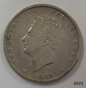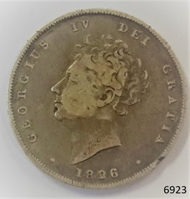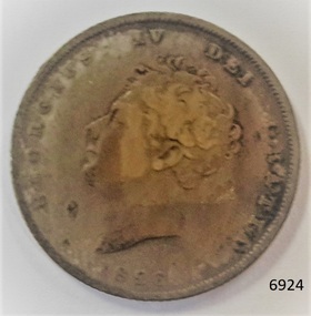
 Flagstaff Hill Maritime Museum and Village
Currency - Coin, 1826
This Great Britain shilling is dated 1826. There were over 6 million of these coins minted during the reign of King George IV, 1820-1830 This coin’s denomination is not inscribed on the coin but it has been identified as a shilling from information about the King George III currency 1816-1820. - This Shilling is 24mm (the same size as this coin) British coins such as this one shilling were in circulation in the colony of Australia until 1910, when the Commonwealth of Australia began producing its own coinage. This coin was minted by the Royal Mint at Royal Mint Court, in Little Tower Hill, London, England. Coins for circulation in the Kingdom of England, Great Britain and most of the British Empire were produced here until the 1960’s when the Royal Mint shifted location to Wales. The obverse side of the coin’s inscription translation is “George IV by the Grace of God”. The engraver of the obverse image was William Wyon. The reverse side’s inscription on the coin is translated " King of The British territories, Defender of the Faith” The engraver of the reverse image was William Wyon. AUSTRALIAN CURRENCY The early settlers of Australia brought their own currency with them so a wide variety of coins, tokens and even ‘promissory’ notes (often called IOU’s) were used in the exchange of goods and services. In 1813 40,000 silver Spanish dollars, purchased by the English government, were delivered to Sydney to help resolve the currency problem reported by Governor Macquarie. The coins were converted for use by punching a hole in the centre of the coin. Both the outer ring, called the holey dollar, and the punched out ‘hole’, called the dump, were then used as the official currency. The holey dollars hold the place of being the first distinctively Australian coins. In 1825 the British Government passed the Sterling Silver Currency Act, making the British Pound the only legal form of currency in the Australian colonies. Not enough British currency was imported into the colony so other forms of currency were still used. In the mid 1800’s Australia entered the Gold Rush period when many made their fortunes. Gold was used for trading, often shaped into ingots, stamped with their weight and purity, and one pound tokens. In 1852 the Adelaide Assay Office, without British approval, made Australia’s first gold coin to meet the need for currency in South Australia after the Gold Rush began. In 1855 the official Australian Mint opened in Sydney, operating as a branch of the Royal Mint in London, and the gold was turned into coins called ‘sovereigns’. Other branches also opened in Melbourne and Perth. Up to the time of Australia becoming a federation in 1901 its currency included British copper and silver coins, Australian gold sovereigns, locally minted copper trade tokens, private banknotes, New South Wales and Queensland government treasury notes and Queensland government banknotes. After Federation the Australian government began to overwrite privately issued notes and prepared for the introduction of its own currency. In 1910 a National Australian Currency was formed, based on the British currency of ‘pounds, shillings and pence’ and the first Commonwealth coining was produced. In 1966, on February 14th, Australia changed over to the decimal currency system of dollars and cents. Australia did not have its own currency in the colonial times. Settlers brought money from other countries and they also traded goods such as grain when currency was scarce. For a long time there was no standardised value for the different currencies. In 1825 British currency became the only official currency in the colony of Australia and coins such as this silver shilling were imported into Australia to replace the mixture of foreign currency. Australia became a Federated nation on 1st January 1901. In 1910 National Australian Currency was formed and Australia produced its own currency, based on the British ‘pounds, shillings and pence’. The British currency was no longer valid. This silver shilling is of national significance as it represents the British currency used in Australia from 1825-1910. Coin, Great Britain shilling. 1826. Silver coin, round. Obverse; King George IV bare head, looking left. Reverse; crowned lion; below, a large crown; below are a shamrock, rose and thistle united. Inscriptions on both sides of coin (denomination not inscribed).Obverse “GEORGIUS IV DEI GRATIA” and “1826” Reverse “BRITANNIARUM REX FIDEI DEFENSOR” flagstaff hill, warrnambool, shipwrecked coast, flagstaff hill maritime museum, maritime museum, shipwreck coast, flagstaff hill maritime village, great ocean road, coin, currency, money, legal tender, australian currency history, royal mint, great britain shilling 1826, king george iv currency, colonial australia currency, william wyon, numismatics