Showing 1594 items
matching prior street
-
 Surrey Hills Historical Society Collection
Photograph, Grovedale Road Quarry in the 1920s - looking south, c1920
The quarry was part of John Butler Maling's property. He was one of the original settlers of the area and farmed the area between Weybridge Street and Whitehorse Road. Clay was quarried from part of this area and used to make the bricks used in the construction of his home, known as 'Ancyra'. This is still extant at the corner of Weybridge and James Streets. Maling grazed cows and used the quarry as a water source. He was the uncle of John Butler Maling, Mayor of Camberwell. He was married to Kate Conlon in 1882. They had 3 children: Silas Young, Alick and Zillah. Maling was born in c1829 in Shepreth, Cambridgeshire; he died in Surrey Hills on 9 October 1912 and is buried in Box Hill Cemetery - CE-*-0586. Mrs Kate Maling (born c1859 in Co Meath, Ireland) died at the property on 8 March 1921. She is buried in Brighton General Cemetery. Probate was valued at over 10,000 pounds and included other properties in Sandringham, Hawthorn and Macedon. At the time of her death the Surrey Hills property was described as being 23 acres with 2 brick houses, 1 cow, 2 heifers and 40 fowls or chickens. The property was subdivided after her death. The property was subdivided into 110 house blocks in c1923 - see Maling's Estate subdivision flyer on the State Library of Victoria's website. This shows that the Grovedale Park site had been acquired by Camberwell Council by this time. An attached newspaper clipping documents prices realised for a cross-section of blocks. The MMBW map of 1925, also on the SLV website, shows the outline of the clayhole / quarry. The quarry was filled in after several drownings or near drownings and the land is now occupied by a park and playground, known as Grovedale Road Park, maintained by the City of Boroondara. Beckett Park is sited on horizon to the left beyond the trees. This documents the landscape prior to close settlement and is material to early building and farming in the Surrey Hills area.Black and white photo of the quarry between Grovedale Road and James Street taken in the 1920s and looking south. In the foreground is an area of water with reeds in the LH corner. Beyond on the high banks there are single storey houses in the background and (?) some light poles. An object that looks like a tank on posts is in a cutting on the far bank.quarries, grovedale road, james street, clay quarries, farming, kate conlon, kate maling, john butler maling, ancyra -
 Surrey Hills Historical Society Collection
Photograph, Grovedale Road Quarry in the 1920s - looking north, c1920
The quarry was part of John Butler Maling's property. He was one of the original settlers of the area and farmed the area between Weybridge Street and Whitehorse Road. Clay was quarried from part of this area and used to make the bricks used in the construction of his home, known as 'Ancyra'. This is still extant at the corner of Weybridge and James Streets. Maling grazed cows and used the quarry as a water source. He was the uncle of John Butler Maling, Mayor of Camberwell. He was married to Kate Conlon in 1882. They had 3 children: Silas Young, Alick and Zillah. Maling was born in c1829 in Shepreth, Cambridgeshire; he died in Surrey Hills on 9 October 1912 and is buried in Box Hill Cemetery - CE-*-0586. Mrs Kate Maling (born c1859 in Co Meath, Ireland) died at the property on 8 March 1921. She is buried in Brighton General Cemetery. Probate was valued at over 10,000 pounds and included other properties in Sandringham, Hawthorn and Macedon. At the time of her death the Surrey Hills property was described as being 23 cres with 2 brick houses, 1 cow, 2 heifers and 40 fowls or chickens. The property was subdivided after her death. The quarry was filled in after several drownings or near drownings and the land is now occupied by a park and playground maintained by the City of Boroondara. Beckett Park is sited on horizon to the left beyond the trees. This documents the landscape prior to close settlement and is material to early building and farming in the Surrey Hills area.Black and white photo of the quarry between Grovedale Road and James Street taken in the 1920s and looking north. In the foreground is an area of water with high banks dividing the horizontal centre. Beyond are paddocks and trees behind which is a row of at least 3 single-storey houses. Light poles can be seen along a distant street. There are many mature trees in the background. The houses and trees are positioned along Whitehorse Road in the vicinity of Westminster Street. Shadows indicate the photo was taken in early morning or evening.quarries, grovedale road, james street, surrey hills, balwyn, clay quarries, ancyra, kate conlon, kate maling, john butler maling, farming -
 Surrey Hills Historical Society Collection
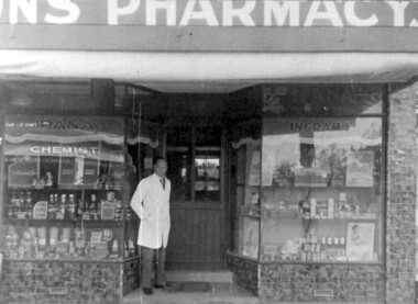
Photograph - Photograph (Copy), Charles Leslie Mitton's Surrey Hills pharmacy, c1933
REF: SHNN article Oct/Nov 1991: Pharmacy was purchased from Mr Nye by C L Mitton in 1933; later moved to 139 Union Road. Research: Stanley Morris Nye (born Ballarat in 1889, son of a Methodist minister; served AIF in WW1) moved to Surrey Hills from Auburn after 1922. He was the first occupant of 131 Union Road which was built in 1924. He is listed in the 1924,1927 and 1931 electoral rolls at 86 Canterbury Road, Surrey Hills. He died aged 44 years in December 1933 and Charles Leslie Mitton took over the business. Charles Leslie Mitton was practising in Newmarket prior to taking over the pharmacy in 1933, the year he also married Ethel Sylvia Stevenson. They lived at 65 Union Road until c1940 when they moved to Kenmare Street, Box Hill North. The pharmacy passed to his son John and daughter Rosalind Lorraine (1937-1997)Black & white photo of a man in a white coat, identified as Charles Leslie Mitton, standing outside his pharmacy in Union Road, Surrey Hills. There is a step up to a central door with glass panels in the top half. The display windows are angled to either side of the door. Within these are shelves displaying many products. The surrounds of the windows are tiled.Note sign for Ipana toothpaste.mitton's pharmacy, businesses, pharmacies, pharmacists, union road shops, mr charles leslie mitton, mr stanley morris nye -
 Surrey Hills Historical Society Collection
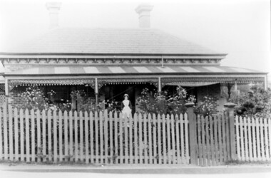
Photograph, Dr Blakie's home and surgery, 171 Union Road, Surrey Hills
The photo would have been taken prior to 1913 as Dr Blakie moved across the road to 174 Union Road to a purpose-built home/surgery designed by architect Arthur Plaisted. He practised at 171 Union Road joining or taking over from Dr Percy Liddle in 1905. The property was rented from the Zeplin family who built the house in 1890, which was known as 'Edgeware', and originally owned all the land bound by the railway, Union Road, Wilson Street and Montrose Street. in the 1920s to 1930s. 1906 became the home of Dr James Blakie, surgery was to the left of house. In 1912 Blakie had house built opposite (now Medical Centre). In 1920s-30s 'Edgeware' became Surrey Hills Police Station. Family details: James Blakie was born in New Zealand to a farming family of Scottish origin. He trained at Otago University with additional study at Cambridge. He married Catherine Miller Martin in 1906. They had 4 children: Geoffrey Noel (1906-1955); Raymond James (1907-1989); Theodore (1913-1913) and a daughter.Black and white photo of a Victorian style home with a slate roof, 2 chimneys, and a striped corrugated iron front veranda to 2 sides with decorative iron fretwork. It has a picket fence and an established garden with a central path leading to the front door. A woman, identified as Nurse Jones, is standing on the veranda.victorian style, homes, edgeware, house names, union road, montrose street, surrey hills, police station, zeplin family, professor zeplin, doctors, medical services, nurses, nurse jones, dr james landells blakie, dr percy liddle, mrs catherine miller blakie, raymond james blakie, geoffrey noel blakie, surrey hills police station, arthur plaisted, architects, edgeware, house names, 1890-1900 -
 Surrey Hills Historical Society Collection
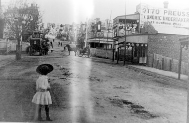
Photograph, Empire Day in Surrey Hills circa 1912
Empire Day celebrations were held from 1908-1912. Prior to the opening of the railway in 1893 the only public transport to Surrey Hills was the Melbourne-Lilydale horse coach which travelled to Surrey Hills down Victoria Street and Mont Albert Road. The fare to Union Road was 9 pence. Photo 16-4a was the number given to the original print provided by the State Savings Bank. Ken Hall made a negative from it, and the reprint of this was given the number 1459. This number was chosen as the catalogue number to avoid confusion with SHP4a. Photo provided by Surrey Hills branch of State Savings Bank of Victoria in 1978 for launch of Surrey Hills Neighbourhood Centre and was one of the first photos in the collection. The inscriptions on the reverse may indicate it was used in the Surrey Hills Neighbourhood News.Black and white photo of Union Road looking south towards Canterbury Road. The street is decorated with lanterns and the Union Jack and other flags for Empire Day celebrations. There is a young girl in the foreground looking towards the railway crossing where there is a horse drawn cab and a horse drawn cart. Business signage includes that for a butcher, Sneddon's Real Estate and Otto Preuss, Economic Undertaker.On rear: "113% "; "Enlarge to 172 mm" and 2 arrows, all in blue biro.union road, empire day celebrations, horse drawn vehicles, undertaker, sneddon real estate, businesses, union road shops, otto preuss -
 Surrey Hills Historical Society Collection
Photograph, Streetscape near the corner of Victoria Crescent and Hotham Street, Surrey Hills
Prior to subdivision for housing this area was paddocks used for grazing of cattle and used as part of the course in the early days of the Surrey Hills Golf Club. Reproduced by permission of Mr John Arnold from his book: "The Riversdale Golf Club - a history, 1892-1977." Copyright to book: Riversdale Golf Club. Surrey Hills Golf Club operated from 1892-1908 then moved and became Riversdale Golf Club. The game was played across paddocks from Trafalgar Street, Mont Albert to Whitehorse Road and down Victoria Crescent to where Box Hill TAFE is now located in Elgar Road. There were problems with cows eating the tee flags! The clubhouse still exists as 30 Trafalgar Street.Black and white photo taken from the centre of a bitumen road which is flanked by bluestone guttering. Nature strips, drive cross-overs and house fences are shown. Trees on the RHS nature strip are pollarded to avoid overhead power and telephone lines. There houses in the background."Bottom: The same view today taken from the intersection of Victoria Crescent and Hotham Street, Surrey Hills."surrey hills golf club, hotham street, victoria crescent, riversdale golf club, surrey hills, john arnold -
 Surrey Hills Historical Society Collection
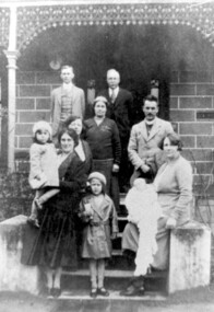
Photograph, Charles Henry Maling and family at 'The Willows', Shepreth Street, Surrey Hills (demolished), 1930s
“The Willows” home of John Butler Maling on south side of Whitehorse Road in Shepreth Street, near Banool Road. He built 2-roomed mud brick cottage in about 1861 extending it in stages into a weatherboard Victorian villa as his family grew. John Butler Maling's uncle (also John Butler Maling lived nearby at 'Ancyra' at 26 Weybridge Street). 'The Willows' was situated on a small farm of c13 acres with a creek running through it, lined with willows. The house was demolished after J B Maling's death in 1931 when the land was subdivided, some of it having been previously bought by the Education Department for the site of Chatham Primary School. J B Maling trained his six sons as builders. Charles Henry and his family are pictured in this photo. Charles Henry Maling (1875-1953) married Katherine Mitchell (1875-1958) in 1901. They lived at 9 Benson Street, Surrey Hills but came to live at 'The Willows' for 5 years prior to 1931 to care for Charles' father. Charles and Katherine are the older man and woman centre back with daughter Ellen Grace, known as Nell (1882-1960) in the front of them. Right front seated on the pillar is daughter Jane Emma (1872-1980) with her baby. Her husband Robert Wilhelm (Bob) Sutherland is the younger man at the back. The occasion is thought to be the christening of their first child. The other people are Rev O Cordell, his wife Mary and their children who are friends visiting from Africa where the donor, Rev Charles Maling, son of Charles Henry Maling was working with the Church Mission Society. A black and white photograph of a group of people standing (one lady sitting) on the front steps of a house.the willows, house names, (mr) john butler maling, whitehorse road, banool road, balwyn, surrey hills, (mr) charles henry maling, (mrs) katherine maling, (miss) nell maling, (mrs) jane sutherland, (mr) bob sutherland, (rev) o cordell, (mrs) mary cordell -
 Surrey Hills Historical Society Collection
Photograph, Alice Eleanor Jackson
Alice Louisa (Louise) Jackson was one of 12 children of George James Jackson and his wife Alice Eleanor (nee Taylor); both of whom were jewellers. One of her brothers, George Hall Jackson, served in WW1. The family lived at 'Handsworth', 7 Russell Street, Surrey Hills. Alice was born 25/9/1892 and died 25/8/1983. She was buried in Box Hill Cemetery - CE-*-2010. REF: Personal communication (email) Ruth Theodoridis, her niece, 30/5/2018: Alice trained at the Austin Hospital prior to WW2. She worked there after graduating and became the charge sister of the ward for terminally ill patients, many of whom were TB patients. After she retired from the Austin she nursed elderly and dying people in the Surrey Hills area. She had had a tricycle made especially for her as she could not ride a bicycle. She would always ride in the centre of the road in case the trike tipped over. She left her estate to the hospital. A black and white photograph of a young lady, identified as Alice Eleanor Jackson, seated between an older couple in front of a house.jeweller, watchmaker, russell street, surrey hills, clothing and dress, nurse, george james jackson, mrs alice eleanor jackson, miss alice louisa jackson -
 Surrey Hills Historical Society Collection
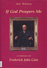
Book, If God prospers me: a portrait of John Frederick Cato, 1990
Purchased when author Ann Blainey spoke to the Surrey Hills Historical Society. There was a Moran and Cato store in Surrey Hills.This biography tells the story of Fred Cato the businessman, who co-founded the Moran and Cato grocery chain. He was an influential Methodist layman, whose major involvements spanned more than forty years, from the Lonsdale Street Central Mission in 1893 to the Aboriginal Methodist Mission at Yirrkala in 1935. He lived to celebrate his 70th birthday.For the History Group, Surrey Hills / with best wishes / Ann.(mr) frederick john cato, grocery trade, business people, methodists, grocers, shops, moran and cato, (ms) ann blainey -
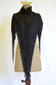
 Brighton Historical Society
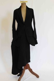
Clothing - Riding habit, 1910s-20s
This item is from the "Barone" Collection. "Barone" (also known as "Seaview") was a stately Brighton home built at 9 Moule Avenue prior to 1855 and demolished in 1986. The house's residents included Edward Elgin Browne (during 1859-72), a Melbourne tea merchant, and the family and descendants of retired Scottish Army captain Archibald Black (during the period 1880-1970). Its neighbors included “St Ninians” owned by the Ward- Cole family, “Seacombe” owned by the Moule family, and the home of James Grahame and his family. The items in the "Barone" collection were largely donated by two of the house's later owners, Mrs Doris Halkyard and Mrs Brian Brandt.An English-made “Busvine” black wool herringbone twill riding habit comprising jacket and safety skirt, (jodhpurs missing) from late 1800’s to early 1900’s. The jacket (.1) features a black short pile silk velvet inset notched lapel collar secured with a single button at the apex of the waist and a single button near the collar for use in inclement weather. The sleeves join the bodice high on the shoulder with a full cut head to the sleeve and a tapered curved shape to the hand. The sleeve secures at the wrist with four black buttons. From the waist the jacket flares over the hip through princess line shaping and finishes with a curved front on either side. The seams of the shaping panels intersect single functional flapped besom pockets on either front panel. The back of the jacket features a centre back seam and two princess-line shaping seams that finish in a double vent on either side of the centre back. The jacket length would have finished approximately just below the bottom of the wearer. The apron fronted safety skirt (.2) secures from the waist at the front of the left thigh with five buttons. Over the wearers, right leg the skirt shapes to accommodate the rider’s right knee whilst sitting sidesaddle with her legs on the horses left flank. The base of the skirt has an elastic strap, which hooks around the rider’s leg to reduce the danger of the rider’s skirt become tangled, should the rider become un-seated. When the riders is not mounted the skirt can be secured with a button around the body to provide additional modesty as well as assist walking without the skirt dragging on the ground.Jacket: Manufacturer's label “Busvine, By serial appointment to Her Majesty The Queen, 4 Brook Street W.” Owner label “Doreen Wright” this label appears far more modern than the manufacturers label. Skirt: Manufacture's label: “J. Busvine and Co, 4 Brook Street, London W." In handwriting “Miss Wingfield” Manufacturers label: Busvines Patent Safety Skirt, protected by two separate patents. 4 Brooks St London West.barone, riding habit, j. busvine and co, seaview, brighton -
 Brighton Historical Society
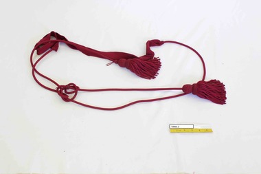
Accessory - Sash
This item is from the "Barone" Collection. "Barone" (also known as "Seaview") was a stately Brighton home built at 9 Moule Avenue prior to 1855 and demolished in 1986. The house's residents included Edward Elgin Browne (during 1859-72), a Melbourne tea merchant, and the family and descendants of retired Scottish Army captain Archibald Black (during the period 1880-1970). Its neighbors included “St Ninians” owned by the Ward- Cole family, “Seacombe” owned by the Moule family, and the home of James Grahame and his family. The items in the "Barone" collection were largely donated by two of the house's later owners, Mrs Doris Halkyard and Mrs Brian Brandt.Woven dark red sash with tassel."Barone" a modern inscription, appears to be in ball point pen.barone, brighton, seaview, sash, military -
 Brighton Historical Society
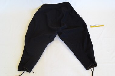
Clothing - Jodhpurs, late 1800s - early 1900s
This item is from the "Barone" Collection. "Barone" (also known as "Seaview") was a stately Brighton home built at 9 Moule Avenue prior to 1855 and demolished in 1986. The house's residents included Edward Elgin Browne (during 1859-72), a Melbourne tea merchant, and the family and descendants of retired Scottish Army captain Archibald Black (during the period 1880-1970). Its neighbors included “St Ninians” owned by the Ward- Cole family, “Seacombe” owned by the Moule family, and the home of James Grahame and his family. The items in the "Barone" collection were largely donated by two of the house's later owners, Mrs Doris Halkyard and Mrs Brian Brandt.A pair of black wool twill women's jodhpurs from late 1800s to early 1900s. The jodhpurs feature a flat flap-front that buttons on either hip with four buttons on either side. The cut of the leg is full tapering through shaped panels to a slim fit over the calf. At the centre front of the leg at the shin, the pant leg is laced closed and finished with brown binding. From the back, the pant hangs loose and full over the bottom, tapering to a slim fit over the calf. Note: These jodhpurs are not a matching piece of the riding habit T0002.1. However, it appears that the same person wore them together as an outfit.barone, riding habit, seaview, jodhpurs, brighton -
 Brighton Historical Society
Clothing - Cape, Pelerine, circa 1890
This item is from the "Barone" Collection. "Barone" (also known as "Seaview") was a stately Brighton home built at 9 Moule Avenue prior to 1855 and demolished in 1986. The house's residents included Edward Elgin Browne (during 1859-72), a Melbourne tea merchant, and the family and descendants of retired Scottish Army captain Archibald Black (during the period 1880-1970). Its neighbors included “St Ninians” owned by the Ward- Cole family, “Seacombe” owned by the Moule family, and the home of James Grahame and his family. The items in the "Barone" collection were largely donated by two of the house's later owners, Mrs Doris Halkyard and Mrs Brian Brandt.Black silk satin, lace and beaded pelerine from c.1890. The pelerine features a silk high stand collar covered in black lace. It secures around the neck and down the centre front to the waist by seven hook and eye closures. A black lace frill extends down the centre front from the throat to the centre front tip of the garment. The shoulders feature a heavy, intricately beaded floral design open sleeve through which the arm would be visible. The sleeve finishes around the elbow in a point, however the beading hangs down to below the hip in a loose fringe. At the back from below the shoulder, the garment shapes in to finish in a tapered 'V' shape over the wearer's coccyx. There is a hand stitched "M" in white thread on the inside lining of the pelerine near the neck.pelerine, brighton, barone, seaview -
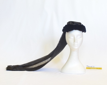 Brighton Historical Society
Headwear - Hat, Mourning bonnet, circa 1915
This item is from the "Barone" Collection. "Barone" (also known as "Seaview") was a stately Brighton home built at 9 Moule Avenue prior to 1855 and demolished in 1986. The house's residents included Edward Elgin Browne (during 1859-72), a Melbourne tea merchant, and the family and descendants of retired Scottish Army captain Archibald Black (during the period 1880-1970). Its neighbors included “St Ninians” owned by the Ward Cole family, “Seacombe” owned by the Moule family, and the home of James Grahame and his family. The items in the "Barone" collection were largely donated by two of the house's later owners, Mrs Doris Halkyard and Mrs Brian Brandt. Brighton Historical Society records indicate this bonnet was worn at the death of Archibald's widow, Isabella Black, in 1912. Other records held place Isabella Black's death in 1915. Navy silk velvet mourning bonnet with black silk train, circa 1915. The bonnet’s shape is created by a horseshoe shaped rib that sits across the crown of the head and shapes in to cover and conceal the back of the head. Across the crown, the bonnet features a navy silk velvet bow. The veil is constructed from a very fine black corded silk and hangs to approximately just below the wearer’s bottom. mourning bonnet, barone, seaview, brighton, isabella black -
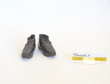 Brighton Historical Society
Footwear - Shoes, Children's shoes, circa 1860
This item is from the "Barone" Collection. "Barone" (also known as "Seaview") was a stately Brighton home built at 9 Moule Avenue prior to 1855 and demolished in 1986. The house's residents included Edward Elgin Browne (during 1859-72), a Melbourne tea merchant, and the family and descendants of retired Scottish Army captain Archibald Black (during the period 1880-1970). Its neighbors included “St Ninians” owned by the Ward Cole family, “Seacombe” owned by the Moule family, and the home of James Grahame and his family. The items in the "Barone" collection were largely donated by two of the house's later owners, Mrs Doris Halkyard and Mrs Brian Brandt.Leather, wood and metal ankle boots c.1860. Dark brown leather upper constructed of two pieces, the foot secures with a metal clasp at the centre front ankle. The upper is adhered to the wooden sole with metal nails. The sole of the forefoot has been reinforced with a metal horseshoe around the edge. On one shoe, a modern inscription (ball point pen) : From "Barone" 9 Moule Ave Brighton. Sept 1970 On other shoe, typewritten on paper: From "Barone", 9 Moule Ave., Brighton Pres. Aug 1970children's shoe, barone, seaview, brighton, 1860s -
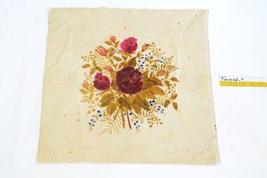 Brighton Historical Society
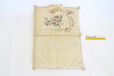
Textile - Cushion cover, Cushion cover (fabric remnant)
This item is from the "Barone" Collection. "Barone" (also known as "Seaview") was a stately Brighton home built at 9 Moule Avenue prior to 1855 and demolished in 1986. The house's residents included Edward Elgin Browne (during 1859-72), a Melbourne tea merchant, and the family and descendants of retired Scottish Army captain Archibald Black (during the period 1880-1970). Its neighbors included “St Ninians” owned by the Ward Cole family, “Seacombe” owned by the Moule family, and the home of James Grahame and his family. The items in the "Barone" collection were largely donated by two of the house's later owners, Mrs Doris Halkyard and Mrs Brian Brandt.A piece of hand painted cream silk velvet believed to be from a cushion cover. Date unknown.barone, seaview, brighton, cushion -
 Brighton Historical Society
Textile - Needle book
This item is from the "Barone" Collection. "Barone" (also known as "Seaview") was a stately Brighton home built at 9 Moule Avenue prior to 1855 and demolished in 1986. The house's residents included Edward Elgin Browne (during 1859-72), a Melbourne tea merchant, and the family and descendants of retired Scottish Army captain Archibald Black (during the period 1880-1970). Its neighbors included “St Ninians” owned by the Ward- Cole family, “Seacombe” owned by the Moule family, and the home of James Grahame and his family. The items in the "Barone" collection were largely donated by two of the house's later owners, Mrs Doris Halkyard and Mrs Brian Brandt.A hand painted and hand embroidered cream silk needle book. Date unknown. This cushion features a delicate hand painted floral design, enhanced with highlight embroidery. It also features a silk rope binding around its edges and a cream silk bow. It appears to have enclosed something as it has a button and loop to secure it in half.cushion, barone, seaview, brighton -
 Brighton Historical Society
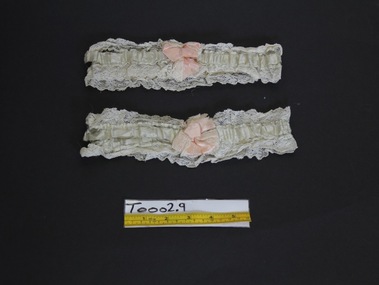
Accessory - Garters, Wedding garters, circa 1910
From the wedding trousseau of Doris Cora Halkyard, nee Wrigley, who married Arthur John Stanley Halkyard in 1912. The couple lived at Barone, 9 Moule Avenue, from around 1951 until 1970. This item is from the "Barone" Collection. "Barone" (also known as "Seaview") was a stately Brighton home built at 9 Moule Avenue prior to 1855 and demolished in 1986. The house's residents included Edward Elgin Browne (during 1859-72), a Melbourne tea merchant, and the family and descendants of retired Scottish Army captain Archibald Black (during the period 1880-1970). Doris, the final member of the Black family to inhabit the house, was Archibald's granddaughter. Barone's neighbours included “St Ninians” owned by the Ward Cole family, “Seacombe” owned by the Moule family, and the home of James Grahame and his family.A pale blue wedding garter featuring a pale pink bow and cream lace edging.wedding garter, doris cora wrigley, doris cora halkyard, stanley halkyard, trousseau, barone, seaview, brighton -
 Brighton Historical Society
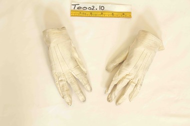
Accessory - Gloves, circa 1853
This item is from the "Barone" Collection. "Barone" (also known as "Seaview") was a stately Brighton home built at 9 Moule Avenue prior to 1855 and demolished in 1986. The house's residents included Edward Elgin Browne (during 1859-72), a Melbourne tea merchant, and the family and descendants of retired Scottish Army captain Archibald Black (during the period 1880-1970). Its neighbors included “St Ninians” owned by the Ward Cole family, “Seacombe” owned by the Moule family, and the home of James Grahame and his family.A pair of ivory kid ladies' gloves secured at the wrist with a metal catch. Circa 1853.Modern inscription on the inside of the glove: "'Barone', worn at Hastings E (presumably England), 1853."kid gloves, barone, seaview, brighton, 1850s -
 Brighton Historical Society
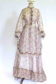
Clothing - Dress, Day dress, circa 1870
The donor and family of this gown were long-term Brighton residents, and the gowns were held by them as family heirlooms prior to donation to Brighton Historical Society. Originally owned by Elizabeth Emma Adams and Cecilia Elizabeth Adams, it is believed that the dress was brought to Australia by either a half brother, James Smith Adams, or a younger sister, Sophia Charlotte Louisa Adams (later known as Mother Rose Columba Adams). Elizabeth and Cecilia were the daughters of James Smith Adams (a squire, 1780-1860) and Elizabeth Emma McTaggart (1793-1843) of Tower House, Woodchester in Gloucester, a property which Elizabeth later inherited. Originally a monastery, Tower House had been converted into a stately home after the Reformation. According to information originally provided by the donor, both this dress and the dress T0004.3 were made for Elizabeth and Cecilia, to be worn at the young Queen Victoria’s first 'drawing room ball' following the end of court mourning in 1838 for her uncle William IV who died in 1837. In 1838 Cecilia would have been twelve years old and Elizabeth would have been ten years old. It is possible that the dress T0004.3 was worn by one of the girls to this event as it is of appropriate dimensions for a child of that age, although its design is very formal and adult. However, it is unlikely that either of the girls wore this dress at the ball due to the size and styling of the dress. It is likely that the dress belonged to one of the girls, but was worn at a later date. Elizabeth was born on 30 June 1828 at Tower House and died on 1 May 1909. She created a scandal when she eloped with her first husband, Thomas Charles Gardiner at the age of 18. The validity of the marriage was later formally investigate and, while it was confirmed as valid, a second church wedding was subsequently held. Thomas died in 1878. Elizabeth subsequently remarried Reverend R. E. Blackwell, but was widowed again by 1889. Cecilia was born on 17 December 1826 and died in 1902 a spinster recluse in England. At the inquest into Cecelia's death in 1904 it was revealed that she had clearly come from a family of means as her home was filled to the brim with highly valuable goods, many in boxes. She was buried in the family vault at Woodchester. Elizabeth and Cecilia's sister Sophia converted to Roman Catholicism in 1851 and became a nun, taking the religious name 'Rose Columba'. In 1883 Mother Rose Columba led a group of eight to Australia, answering a call for Dominican sisters to nurse the sick in Adelaide. Upon arrival, she founded St. Dominic's Priory and the Church of Perpetual Adoration in North Adelaide, using her inheritance to build the chapel. Elizabeth's second son, George Henry Somerset, who inherited the Adams family estate dropped the 'i' in Gardiner and added the maiden name of his grandmother. Therefore, the family name has now become Gardner McTaggart. These Adams family entries have been updated with information provided by Dr Herbert Gardner McTaggart, great-grandson of George Henry Somerset in April 2016. Mr McTaggart contacted the society after finding our entries online.A hand sewn white purple, pink, green, blue and yellow floral silk chiffon dress from circa 1870. The dress consists of two pieces worn together as a dress. This dress has received a great deal of mending and alteration and so it is difficult to be sure of what constitutes its original state. The following description is of its current state. The bodice has a high neck with a simple shallow band collar, an olive braid and a press stud closure. The bodice fastens down the centre front with ten hook and eyes closures and two sets of ribbon ties . The bodice has three darts providing shaping into the waistline. The bodice finishes at the waist and gently tapers towards the front creating a 'V' line. Down the centre front from the neck to the waist concealing the bodice opening is a pressed pleated ruffle of the dress fabric and a line of olive braid. The dress features pagoda sleeves finished at the hem with pressed pleated ruffle of the dress fabric, a line of olive braid and a silk fringe of 4 cm pale pink and white. The skirt part of the bodice section attaches to the front of the dress with two hooks and eyes on the left hand side of the waist. The fabric drops down to approximately the knees at the front, curving up and splitting on either side over the hip. The edge of this piece is also trimmed with a pressed pleated ruffle of the dress fabric and a line of olive braid. Just below the hip on either side is a large bow of pink, cream, purple and green taffeta. The bodice at the back is shaped with four panels into the waistline. Where it joins the bodice skirt the skirt is pleated, creating fullness. The skirt of the dress ensemble secures at the waist on the left hand side. At the front it has two pleats (that may have been repositioned during repair), and is fully gathered at the back. At the front the dress falls to the floor whilst at the back it is longer to accommodate the bustle and possibly a small train.cecilia elizabeth adams, elizabeth emma adams, 1870s fashion, tower house, woodchester, james smith adams, elizabeth emma mctaggart, mary rose columba adams, sophia charlotte louisa adams -
 Brighton Historical Society
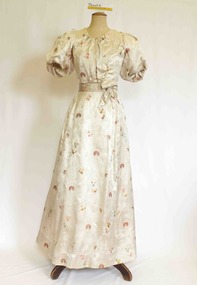
Clothing - Dress, Evening dress, circa 1890 (bodice), circa 1840 (skirt)
The donor and family of this gown were long-term Brighton residents, and the gowns were held by them as family heirlooms prior to donation to Brighton Historical Society. Originally owned by Elizabeth Emma Adams and Cecilia Elizabeth Adams, it is believed that the dress was brought to Australia by either a half brother, James Smith Adams, or a younger sister, Sophia Charlotte Louisa Adams (later known as Mother Rose Columba Adams). Elizabeth and Cecilia were the daughters of James Smith Adams (a squire, 1780-1860) and Elizabeth Emma McTaggart (1793-1843) of Tower House, Woodchester in Gloucester, a property which Elizabeth later inherited. Originally a monastery, Tower House had been converted into a stately home after the Reformation. According to information originally provided by the donor, the skirt portion of this dress (along with the bodice T0004.3) was made for either Elizabeth or Cecilia to be worn at the young Queen Victoria’s first 'drawing room ball' following the end of court mourning in 1838 for her uncle William IV who died in 1837. In 1838 Cecilia would have been twelve years old and Elizabeth would have been ten years old. It is possible that this dress was worn by one of the girls to this event as it is of appropriate dimensions for a child of that age, although its design is very formal and adult. Elizabeth was born on 30 June 1828 at Tower House and died on 1 May 1909. She created a scandal when she eloped with her first husband, Thomas Charles Gardiner at the age of 18. The validity of the marriage was later formally investigate and, while it was confirmed as valid, a second church wedding was subsequently held. Thomas died in 1878. Elizabeth subsequently remarried Reverend R. E. Blackwell, but was widowed again by 1889. Cecilia was born on 17 December 1826 and died in 1902 a spinster recluse in England. At the inquest into Cecelia's death in 1904 it was revealed that she had clearly come from a family of means as her home was filled to the brim with highly valuable goods, many in boxes. She was buried in the family vault at Woodchester. Elizabeth and Cecilia's sister Sophia converted to Roman Catholicism in 1851 and became a nun, taking the religious name 'Rose Columba'. In 1883 Mother Rose Columba led a group of eight to Australia, answering a call for Dominican sisters to nurse the sick in Adelaide. Upon arrival, she founded St. Dominic's Priory and the Church of Perpetual Adoration in North Adelaide, using her inheritance to build the chapel. Elizabeth's second son, George Henry Somerset, who inherited the Adams family estate dropped the 'i' in Gardiner and added the maiden name of his grandmother. Therefore, the family name has now become Gardner McTaggart. These Adams family entries have been updated with information provided by Dr Herbert Gardner McTaggart, great-grandson of George Henry Somerset in April 2016. Mr McTaggart contacted the society after finding our entries online.A hand and machine sewn cream, pale blue, orange and gold embroidered satin formal dress, the bodice dates from circa 1890. This dress shares a skirt with T0004.3, which dates from circa 1840. The bodice features a high scoop neckline with gathers at the base of the scoop and directly below where the bodice finishes creating fullness over the bust. The bodice front encloses the bust with a right panel over the top of a left panel and securing with two hook and eye closures over the left shoulder. The panels are secured together with 15 hook and eye closures. The sleeves are set neatly on the true shoulder and are elongated full puffs to just above the elbow. The fullness is created by nine pleats from the top of the shoulder over the back of the shoulder. At the base of the sleeve the fullness is gathered just above the elbow. At the centre back of the bodice are four inward facing pleats running from the centre neck to the waist. The bodice is secured around the waist with a tape and four hook and eye closures. The bodice is boned around the sides and back of the torso with eight bones. This bodice is finished at the waist with a pleated cummerbund of the dress fabric that is designed to appear to be a sash with two decorative bows. One front left of centre and one back right of centre. The skirt secures at the waist with an opening to the left of centre at the back. The skirt gathers tightly at the centre back with a dart on either side. The skirt has a front central panel and the skirt falls to floor length. At the back, the skirt is also floor length. The back of the skirt may have been modified at some time and may have originally finished in a train. It would be more appropriate to the period of the bodice, and the believed use of the dress with a train.cecilia elizabeth adams, elizabeth emma adams, queen victoria, tower house, woodchester, james smith adams, elizabeth emma mctaggart, sophia charlotte louisa adams, 1890s fashion -
 Brighton Historical Society
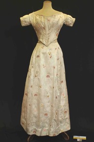
Clothing - Dress, Evening dress, circa 1840
The donor and family of this gown were long-term Brighton residents, and the gowns were held by them as family heirlooms prior to donation to Brighton Historical Society. Originally owned by Elizabeth Emma Adams and Cecilia Elizabeth Adams, it is believed that the dress was brought to Australia by either a half brother, James Smith Adams, or a younger sister, Sophia Charlotte Louisa Adams (later known as Mother Rose Columba Adams). Elizabeth and Cecilia were the daughters of James Smith Adams (a squire, 1780-1860) and Elizabeth Emma McTaggart (1793-1843) of Tower House, Woodchester in Gloucester, a property which Elizabeth later inherited. Originally a monastery, Tower House had been converted into a stately home after the Reformation. According to information originally provided by the donor, both this dress and the dress T0004.1 were made for Elizabeth and Cecilia, to be worn at the young Queen Victoria’s first 'drawing room ball' following the end of court mourning in 1838 for her uncle William IV who died in 1837. In 1838 Cecilia would have been twelve years old and Elizabeth would have been ten years old. It is possible that this dress was worn by one of the girls to this event as it is of appropriate dimensions for a child of that age, although its design is very formal and adult. Elizabeth was born on 30 June 1828 at Tower House and died on 1 May 1909. She created a scandal when she eloped with her first husband, Thomas Charles Gardiner at the age of 18. The validity of the marriage was later formally investigate and, while it was confirmed as valid, a second church wedding was subsequently held. Thomas died in 1878. Elizabeth subsequently remarried Reverend R. E. Blackwell, but was widowed again by 1889. Cecilia was born on 17 December 1826 and died in 1902 a spinster recluse in England. At the inquest into Cecelia's death in 1904 it was revealed that she had clearly come from a family of means as her home was filled to the brim with highly valuable goods, many in boxes. She was buried in the family vault at Woodchester. Elizabeth and Cecilia's sister Sophia converted to Roman Catholicism in 1851 and became a nun, taking the religious name 'Rose Columba'. In 1883 Mother Rose Columba led a group of eight to Australia, answering a call for Dominican sisters to nurse the sick in Adelaide. Upon arrival, she founded St. Dominic's Priory and the Church of Perpetual Adoration in North Adelaide, using her inheritance to build the chapel. Elizabeth's second son, George Henry Somerset, who inherited the Adams family estate dropped the 'i' in Gardiner and added the maiden name of his grandmother. Therefore, the family name has now become Gardner McTaggart. These Adams family entries have been updated with information provided by Dr Herbert Gardner McTaggart, great-grandson of George Henry Somerset in April 2016. Mr McTaggart contacted the society after finding our entries online.A hand sewn cream, pale blue, orange and gold embroidered satin formal dress, the bodice dates from circa 1840. This dress shares a skirt with T0004.2, which dates from a different period (circa 1890). The bodice features a wide shallow neckline finished with a beige coloured cord in two decorative lines. The sleeve is set on the true shoulder and is a short fitted sleeve with decorative gathering and two lines of corded detail. The bodice is shaped to the body with 2 sets of six fine knife pleats diagonally positioned narrower over the waist and spreading out over the bust. These pleats are secured with six double lines of stitching. The bodice finishes high on the waistline at either side and points down to a point over the centre front. The base of the bodice is finished with a piped edge and beige decorative cording. The bodice encloses the body at the centre back where it has holes that presumably would have held lacing. The back features four diagonal knife pleats finishing at the centre back and splaying out over the shoulders. The waistline at the back features only a very gentle point.cecilia elizabeth adams, elizabeth emma adams, james smith adams, elizabeth emma mctaggart, sophia charlotte louisa adams, queen victoria, drawing room ball, 1840s fashion, tower house, woodchester -
 National Wool Museum
Jumper
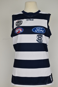
The jumper was donated to the National Wool Museum in early 2019 from the Geelong Football Club. The jumper is the fourth in the 'country game' range. The oringal 2016 jumper was designed to commemorate a 'country game' against the Essendon Football Club prior to the start of the 2016 AFL Season. The four themes depicted in that jumper included: livestock, wool, wine and wheat. the 2016 jumper can be viewed as entry 7613.White sleeveless Geelong football jumper. The jumper has a large number 4 printed on the back. On the front of the Jumper it has the words Cotton On printed bellow the neck line as well as the emblems for Powercor Country round, the AFL Ford and the Geelong Football Club.Wording. Printed: COTTON ON POWERCOR COUNTRY FESTIVAL AFL / Ford GEELONG CATS EST 1859 FOOTBALL CLUB Reverse. Wording. Printed: 4 Fordgeelong football club, country round -
 Vision Australia
Text, Association for the Advancement of the Blind Hostel Committee 3 September 1947 to 7 May 1958, 1947-1958
Minutes of the monthly meetings of the AAB Hostel Committee to discuss items related to the running of the Mens Hostel at 11 Lara Street, South Yarra and the Women's Hostel at 54 The Avenue, Windsor. Agenda topics included Receipts and Accounts, Admissions, reports from both hostels and Official Visitors, rules of the hostel including no washing on Sundays (p.75), the closure of the Mens Hostel (p.78), regret that the sale of the Women's Hostel was not advised prior, and that when a new hostel is established, it be named in honour of Mrs L. Hutchinson (p.173). 1 paper registerassociation for the advancement of the blind -
 Port Fairy Historical Society Museum and Archives
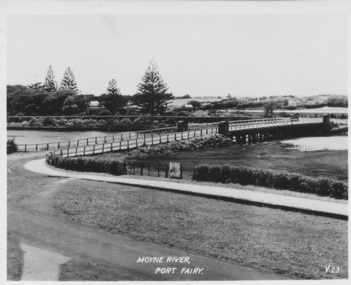
Postcard, Moyne River Port Fairy
This bridge was built in 1902, replacing a previous structure that crossed the Moyne River from 1857 and linked Belfast with Belfast East, as the two areas of Port Fairy were then known. Prior to that, passage over the river was via a ford (an underwater stone track that allowed wagons to cross when the river was low) located just north of where the current car bridge stands. The present bridge survived the great flood of 1946, but has been the subject of innumerable patch-up jobs over its 114 years. In 2012, the bridge underwent a detailed structural assessment and was given the OK for the next eight to 10 years, notwithstanding the need for regular maintenance works. At the time, it was estimated a new bridge would cost between $2-3 million. It was extensively refurbished in 2016Sole means for traffic to cross to the east side of Port FairyBlack and white photographMoyne River Port Fairyriver, moyne, bridge, road -
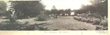 Port Fairy Historical Society Museum and Archives
Photograph, A.C. Aberline, The Gardens, Port Fairy
Gardens, Port Fairy - flowers & lawns panoramic view. The Port Fairy Botanical Gardens were formed in 1856 making it one of the earliest gardens in Victoria. The first curator was James Prior, he was paid fifty-two pounds per annum. He was an outstanding curator having been apprenticed to the trade in England at the age of 12, his brother Edward in later years was the Curator of the Koroit Gardens. Prior retired in 1903. During the years of his curatorship Port Fairy was said to have the best gardens outside the city of Melbourne, he was constantly in touch with Baron Von Mueller and later Guilfoyle of the Royal Botanical Gardens of Melbourne. In the early years plants from all over the world were planted here with varying rates of success many of them sent by Baron Von Mueller. In the 1930’ and 40’s the gardens were still very beautiful, and the curator was Roy Manuell. The beautiful iron gates at the entrance were destroyed in the 1946 floods and were replaced in 1989 using some of the material from the original gates. From the 1950’s on the gardens went into a state of decline, much being taken up by the caravan park until in 1986, after a public meeting ‘Friends of the Gardens’ was founded when the entrance section was restored. Black and white Photograph of Port Fairy Gardens glued to cardboard as a mountThe Gardens Port Fairy—- A.C.Aberline, 26 Faversham Road, Canterbury gardens, botanical -
 Port Fairy Historical Society Museum and Archives
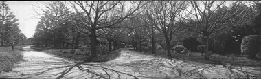
Photograph, A.C. Aberline, Gardens, Port Fairy
Gardens, Port Fairy panoramic view. The Port Fairy Botanical Gardens were formed in 1856 making it one of the earliest gardens in Victoria. The first curator was James Prior, he was paid fifty-two pounds per annum. He was an outstanding curator having been apprenticed to the trade in England at the age of 12, his brother Edward in later years was the Curator of the Koroit Gardens. Prior retired in 1903. During the years of his curatorship Port Fairy was said to have the best gardens outside the city of Melbourne, he was constantly in touch with Baron Von Mueller and later Guilfoyle of the Royal Botanical Gardens of Melbourne. In the early years plants from all over the world were planted here with varying rates of success many of them sent by Baron Von Mueller. In the 1930’ and 40’s the gardens were still very beautiful, and the curator was Roy Manuell. The beautiful iron gates at the entrance were destroyed in the 1946 floods and were replaced in 1989 using some of the material from the original gates. From the 1950’s on the gardens went into a state of decline, much being taken up by the caravan park until in 1986, after a public meeting ‘Friends of the Gardens’ was founded when the entrance section was restored. Black and white panoramic photograph of the bare limbed trees in the botanical gardensGardens, Port Fairy- A.C.Aberline, 26 Faversham Road, Canterburygardens, winter, trees, botanical -
 Port Fairy Historical Society Museum and Archives
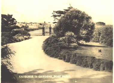
Postcard, Entrance to Gardens, Port Fairy
Pedestrian entrance to the Botanical Gardens. The Port Fairy Botanical Gardens were formed in 1856 making it one of the earliest gardens in Victoria. The first curator was James Prior, he was paid fifty-two pounds per annum. He was an outstanding curator having been apprenticed to the trade in England at the age of 12, his brother Edward in later years was the Curator of the Koroit Gardens. Prior retired in 1903. During the years of his curatorship Port Fairy was said to have the best gardens outside the city of Melbourne, he was constantly in touch with Baron Von Mueller and later Guilfoyle of the Royal Botanical Gardens of Melbourne. In the early years plants from all over the world were planted here with varying rates of success many of them sent by Baron Von Mueller. In the 1930’ and 40’s the gardens were still very beautiful, and the curator was Roy Manuell. The beautiful iron gates at the entrance were destroyed in the 1946 floods and were replaced in 1989 using some of the material from the original gates. From the 1950’s on the gardens went into a state of decline, much being taken up by the caravan park until in 1986, after a public meeting ‘Friends of the Gardens’ was founded when the entrance section was restored. Black and white photograph of the pedestrian entrance to the Botanical Gardens gradens, botanical, path, gates, entrance -
 Port Fairy Historical Society Museum and Archives
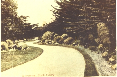
Postcard
Entrance to Gardens - Port Fairy. The Port Fairy Botanical Gardens were formed in 1856 making it one of the earliest gardens in Victoria. The first curator was James Prior, he was paid fifty-two pounds per annum. He was an outstanding curator having been apprenticed to the trade in England at the age of 12, his brother Edward in later years was the Curator of the Koroit Gardens. Prior retired in 1903. During the years of his curatorship Port Fairy was said to have the best gardens outside the city of Melbourne, he was constantly in touch with Baron Von Mueller and later Guilfoyle of the Royal Botanical Gardens of Melbourne. In the early years plants from all over the world were planted here with varying rates of success many of them sent by Baron Von Mueller. In the 1930’ and 40’s the gardens were still very beautiful, and the curator was Roy Manuell. The beautiful iron gates at the entrance were destroyed in the 1946 floods and were replaced in 1989 using some of the material from the original gates. From the 1950’s on the gardens went into a state of decline, much being taken up by the caravan park until in 1986, after a public meeting ‘Friends of the Gardens’ was founded when the entrance section was restored. Hand painted photograph of winding path in Botanical GardensGardens Port Fairythe gardens, gates, botanical, griffith street -
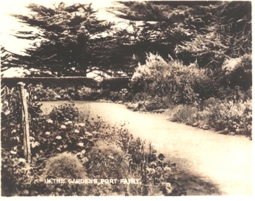 Port Fairy Historical Society Museum and Archives
Postcard, In the Gardens, Port Fairy
The Port Fairy Botanical Gardens were formed in 1856 making it one of the earliest gardens in Victoria. The first curator was James Prior, he was paid fifty-two pounds per annum. He was an outstanding curator having been apprenticed to the trade in England at the age of 12, his brother Edward in later years was the Curator of the Koroit Gardens. Prior retired in 1903. During the years of his curatorship Port Fairy was said to have the best gardens outside the city of Melbourne, he was constantly in touch with Baron Von Mueller and later Guilfoyle of the Royal Botanical Gardens of Melbourne. In the early years plants from all over the world were planted here with varying rates of success many of them sent by Baron Von Mueller. In the 1930’ and 40’s the gardens were still very beautiful, and the curator was Roy Manuell. The beautiful iron gates at the entrance were destroyed in the 1946 floods and were replaced in 1989 using some of the material from the original gates. From the 1950’s on the gardens went into a state of decline, much being taken up by the caravan park until in 1986, after a public meeting ‘Friends of the Gardens’ was founded when the entrance section was restored. Black and white photograph of a path through the Botanical GardensIn the Gardens Port Fairygardens, botanical, path, griffith street, trees