Showing 11558 items matching " maps"
-
 Clunes Museum
Map, A.C. BROOKS GOVERNMENT PRINTER MELBOURNE, EGLINTON COUNTY OF TALBOT, 1965
MAP OF EGLINTONMAP OF EGLINTON, COUNTY OF TALBOT PRINTED ON CANVAS WITH PLASTIC TAB FOR HANGING. MAP SHOWS TOWN ALLOTMENTSADMINISTRATIVE STAMP ON BOTTOM LEFT AND ON THE BACK OF THE MAP ANOTHER STAMP - NORTHERN DIVISION (299) FORESTS COMMISSION BENDIGOeglinton, historical map -
 Bendigo Military Museum
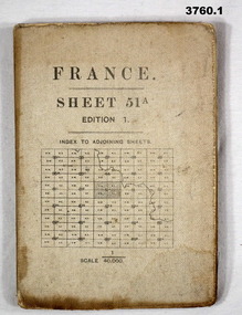
Map - MAPS, FRANCE WW1, 1915 - 1917
... Maps ...(.1) Areas covered by this map, Somain to Valenciennes, Ramillies to Beaudignies. (.2) Areas covered on this map, Bellicourt to Tupigny, St Quentin to Guise. (.3) Areas covered on this map, Heslin to lens, Domart to Baupaume. (.4) Areas covered on this map, Dieppe to Le Quesnoy, Monville to Bonniers. (.5) Same as (.2) Items relate to William Alexander No 502 AIF. Refer 3746.3 for his service details.(.1) Map, France, sheet 51A, Edition 1, scale 1:40,000, Ordnance survey 1916, gauze lined, rear has glossary of terms French to English. (.2) Map, France, sheet 62B, first edition, scale 1:40,000, Ordnance survey December 1917, gauze lined, rear has glossary of terms French to English. (.3) Map France, Lens 11, scale 1:100,000, OSO 1915, gauze lined. (.4) map, France, Dieppe 16, scale 1:100,000, general staff No 2364, War Office 19– gauze lined. (.5) Map, France (same as (.2)(.2 & .5) On rear hand written “124 A.L.T.M.B P179/5maps, france -
Whitehorse Historical Society Inc.
Map, Nunawading Map. Large Scale, 1960's ?
... Maps ...Sheet 2, Nunawading map. Sections 78 -97.Sheet 2, Nunawading map. Sections 78 -97.Sheet 2, Nunawading map. Sections 78 -97.maps, nunawading -
 Whitehorse Historical Society Inc.
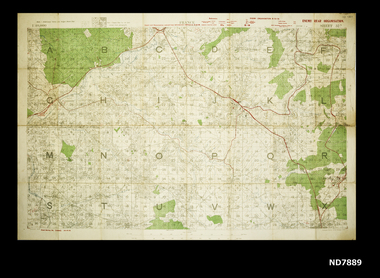
Map - WW1 map of France, WW1 map of France - regional. Field Survey Map of Enemy Rear Organisation, 08/10/1918
... Maps ...Enemy Rear Organisation map Scale 1 : 40,000Field Survey Map of Enemy Rear Organisationnon-fictionEnemy Rear Organisation map Scale 1 : 40,000maps, world war 1914 - 1918 -
 Whitehorse Historical Society Inc.
Map - Parish Map, Parish of Nunawading, 1892
... Maps ...A map copied from 'Directory maps - parishes and counties' dated 26 Nov 1892. Compiled and lithographed by G.S. Bonney. The map includes roads, railway, stations, names of property owners. It has a scale [ca. 1:31,680] 40 chains to an 1 inch.A map copied from 'Directory maps - parishes and counties' dated 26 Nov 1892. Compiled and lithographed by G.S. Bonney. The map includes roads, railway, stations, names of property owners. It has a scale [ca. 1:31,680] 40 chains to an 1 inch.non-fictionA map copied from 'Directory maps - parishes and counties' dated 26 Nov 1892. Compiled and lithographed by G.S. Bonney. The map includes roads, railway, stations, names of property owners. It has a scale [ca. 1:31,680] 40 chains to an 1 inch.maps, parish of nunawading -
 Bendigo Military Museum
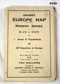
Map - MAP of EUROPE, Craigie"s Europe Map, 1939
... Maps ...The map features the areas and populations of all European countries as per 1939. Part of the collection re Frederick Gardner Davey DFC No 410533 RAAF. Refer Cat No 3536P for his service details.Folded map in black and white. Coloured British and German flags are pinned to countries on the map.On the front cover in pencil, “2/-“. (2 schillings)maps, europe -
Whitehorse Historical Society Inc.
Map, Shire of Boroondara, Parish of Nunawading, 1904
... Maps ...Photocopy of printed map extending from Camberwell to Middleborough Road.Photocopy of printed map extending from Camberwell to Middleborough Road. note on verso: From a book of maps dated 1904.Photocopy of printed map extending from Camberwell to Middleborough Road. maps, shire of boroondara, parish of nunawading -
 Bendigo Military Museum
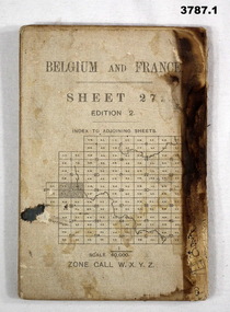
Map - MAPS, BELGIUM WW1, 1912 - 1917
... Maps ...(.1) Areas covered on this map, Bollezeele to Poperinghe, Arques to Meteren. (.2) Areas covered on this map, BourBourg to Poelcapple, Reemilly to Armentieres. (.3) Areas covered on this map, Bruges, Neuzen, Ghent. (.4) Areas covered on this map, Alost, Loulain, Soignes, St Germain. (.5) Areas covered on this map, Roulers, Oosterzeele, Lille, Thoriecourt. Items relate to William Alexander No 502 AIF. Refer 3746.3 for his service details.(.1) Map, Belgium and France, sheet 27, Edition 2, scale 1:40,000, zone call W.X.Y.Z, Ordnance survey May 1917, gauze lined. (.2) Map, Belgium, Hazebrouck 5A, Edition 2, scale 1:100,000, Ordnance survey 1916, gauze lined. (.3) Map, Belgium, Ghent 2, scale 1:100,000, War Office June 1915. (.4) Map, Belgium, Brussels 6, scale 1:100,000, Drawn at War Office, Ordnance survey 1912. (.5) Map, Belgium, Tournai 6, scale 1:100,000, War Office Ordnance survey July 1912.(.1) On rear, “Glossary of terms”maps, belgium, france -
 Bendigo Military Museum
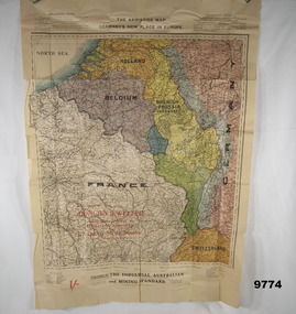
Map - ARMISTICE MAP, WW1, The Industrial Australian and Mining Standard, Melbourne and Sydney>, Post June 1919
... maps ...The different colours cover France, Belgium, Luxembourg, Alsace, Lorraine, The Rhine, Nuetral zone, Germany, Switzerland, Holland, Rhenish Prussia (Germany) Item in the collection relating to C.J.C. McQuie MM, refer Cat No 9680P for his service details.Map in colour showing a large section of Europe, the boundaries set up after the Armistice in 1919, countries are in different colours.At the top, "The Armistice map, Germany's new place in Europe"maps, europe, armistice, mcquie -
Clunes Museum
Map, Township of Clunes - Parish of Clunes - County of Talbot
Map of Clunes Township in 19511 X PHOTOCOPY OF MAP, (COMPRISING A NUMBER OF A4 SHEETS TAPED TOGETHER) SHOWING LOT NUMBERS AND NAMES OF LANDHOLDER. REFERENCE GAZ 1951.1480. SCALE 30 CHAINS = 1 INCH 1 X PHOTOCOPY OF MAP, (COMPRISING A NUMBER OF A4 SHEETS TAPED TOGETHER) SHOWING LOT NUMBERS AND NAMES OF LANDHOLDER. REFERENCE: G76359 GENERAL FILE TOWNSHIP RESIDENTIAL ALLOTMENTS SCALE 30 CHAINS = 1 INCHNOTATED IN PURPLE CRAYON ON SECOND MAP: AS AT LATE 1984 COPY OF MAP FROM LAND TITLES OFFICE BALLARATtownship of clunes map, 1951 -
 Ballarat Tramway Museum
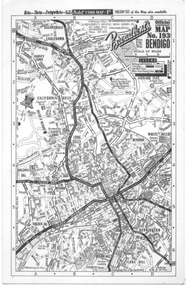
Map, Broadbent's, "Broadbent's Map 193 Bendigo", 1950s
... maps ...Map of Bendigo showing streets, with the tram routes in dotted lines. Has a legend, scale and continuation maps. Gives an address of 475 Collins St Melbourne and a Melbourne telephone number - MR 2021.Yields information about Bendigo and its tram lines. Broadbents was a prolific publisher of maps. Map - single sided card, pocket map priced at 1/- - undated.bendigo, tramways, tram lines, maps, broadbents -
Clunes Museum
Map - MAPS, A.C. BROOKS GOVERNMENT PRINTER MELBOURNE
... MAPS ....1 PARISH OF CLUNES, COUNTY OF TALBOT. (3 COPIES) (1) STAMP: DRAWING OFFICE RECORDS COPY, STATE ELECTRICITY COMMISSION OF VICTORIA. ELECTRICITY DEPARTMENT (THIS PLAN MUST NOT BE TAKEN FOR FIELD USE. PLEASE DO NOT DEFACE) C71 ON LEFT BOTTOM CORNER, CLUNES SHEET 1 (2) '19' HANDWRITTEN ON ALL FOUR CORNERS AND PLASTIC TAB FOR HANGING (3) PLASTIC TAB FOR HANGING .2 MAP BECKWORTH COUNTY OF TALBOT (3 COPIES) (1) IN RED: B-61. L.4855. THE ALLOTMENTS COLOURED BROWN ARE FREEHOLD (2) WITH PLASTIC TAB FOR HANGING (3) WITH PLASTIC TAB FOR HANGING. '14' HAND WRITTEN IN ALL 4 CORNERS AND VARIOUS PENCIL NOTATIONS ON THE MAP..1.2 DRAWN AND REPRODUCED AT THE DEPARTMENT OF LANDS & SURVEY MELBOURNE. PRICE 2/- .1 IN PENCIL ON BOTTOM ' 211 ' 20%parish of clunes, electricity supply department, beckworth -
 Geelong RSL Sub Branch
Silk Map - Asiatic Series, circa 1940s
Silk Maps were produced by Great Britain and United States during WW2 some 3.5 million Silk Maps and cloth maps were produced for Allied Military Personnel.This Silk Map is an original map from the WW2 era.An oblong, cream colour silk map, Asiatic Series.AAF Cloth Map-Asiatic Series Side 1 - No 34 Southeast China Side 2 - No35 - Northeast Chinaww2, silk map, great britain, united states -
 Vision Australia
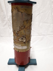
Map - Object, R.F. Tunley, Braille cylinder map, 1940-1950s
This map was produced by Richard Francis Tunley and given to the Victorian Braille Library for use by it's patrons. Mr Tunley was a prolific Braille map maker as well as producing other items for blind and vision impaired children, advocated for compulsory education for blind and deaf children and established the Queensland Braille Map and Model Club. Leading by example, his maps were treasured by those who used them and were an outstanding piece of craftsmanship. In this example, the metal cylinder sits on a wooden base and can be turned via a handle in the wooden top or rotating the sides. A brailled red metal plate occupies the bottom third, and large continents have a metal plate, cut to shape, upon which braille country/continent names are placed. Major rivers are traced through raised lines in the metal continental plates, twisted wire traces shipping routes with associated brailled metal plates, raised metal pins in some major locations and more explanatory plates sit in various oceans.1 metal cylindrical map with tactile markersCommercial & Strategic Map of the British Empire Presented to the Victorian Braille Librarybraille library of victoria, r.f. tunley -
 Bendigo Military Museum
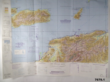
Map - MAPS, EAST TIMOR, US Govt et al, 1975 - 1976
... Maps ...1. This is a coloured map. It's scale is 1.250,000 - called a jpoint operations graphic. It covers the North side of East Timor. Dili is in the centre. Its shows 4 Islands to the north of Timor. It shows Savu Fea, Ombai Strait, Wetar Strait. On bottom left of map it shows Batheade and the start of the New Border. Map - Series 159. Sheet 5C- 51-4. Edition 3-GSGS. 2. This is a coloured map. Its scale is 1.250,000 called a joint Operations Graphic. It manly covers West Timor. It shows Savu Sea in North and Timor Sea on south side. Series 1501. Sheet SC 51.7. Edition 3-GSGS. 3. This a coloured map. It's scale is 1.250,000. Joint operations graphic. This map shows the south side of East Timor and the Timor Sea. This map shows a highlighted New border. The major towns on South coast are KAMFNASA, BETANO. Map series 1501. Sheet SC 51-8. Edition 3 GSGS.1. Has highlighted "7 BSG" on coast. All maps show East Timor border highlighted in pink.east timor, maps, interfet -
 Eltham District Historical Society Inc
Book, Melway Great Melbourne street directory including Geelong, Phillip Island Healesville, Bellarine & Mornington Peninsulas, 1998
... maps ...25th edition. Coloured detailed maps accessed by a street or location index. Cover: (Includes) New Southbank map including Crown Complex, enlargements of Footscray and Kensington, bike paths, walking tracks & horse trails, latest public transport information, South east Australia tours maps, Vic Roads new route numbers, map of Australia1 atlas (22, 772 p.) : col. maps ; ISSN 03113957streets, maps, roads, melbourne -
Beechworth Honey Archive
Map- Everton
Map compiled from 1975 aerial photography. Printed in 1979.Map shows Everton, Ovens River, Beechworth- Wangaratta Rd, former Wangaratta- Bright railway. Scale 1:25,000. Printed colour on paper.Map labelled Everton. No. 8225-3-3.map, everton, ovens river, bright, railway, aerial, photography, paper, beechworth honey -
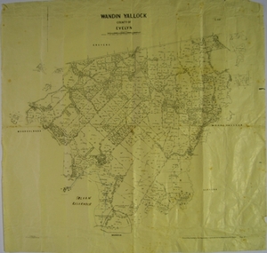 Yarra Ranges Regional Museum
Map, H J Green, Acting Govt. Printer, Wandin Yallock, County of Evelyn (Parish Plan), c. 1910 - 1920
... Maps ...Parish Plan of Wandin Yallock. Location of Silvan Reservoir marked in ink on map.Parish Plan of Wandin Yallock. Location of Silvan Reservoir marked in ink on map. wandin yallock, maps -
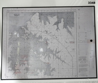 Bendigo Military Museum
Map - MAP, MOUNTED, WW2, Possible pre WW2
This sketch map is a copy of the original found in Tokyo after the 1939 - 1945 War. Note that Japanese writing that has been added.Copy of Sketch Map of Darwin prepared by Australian Section Imperial General Staff. Mounted on board backing with laminated surface added, black border around edge, hanging strap on back. A detailed map of Darwin area giving convergence & time correction figures for artillery purposes.Top left words: “Sketch Map Darwin”map, darwin -
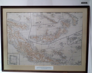 Bendigo Military Museum
Map - MAP, FRAMED
... Maps ...Printed on border under map: These escape maps were carried in the zip pockets of life jackets by fighter pilots in WW2. This map was presented to A.S.R on the 12/7/79 by Councillor Ian McKenzie, Mayor of Eaglehawk who served as a fighter pilot in 78 Sqn. in Sth. W. Pacific are during 1943-44.Map of eastern section of New Guinea. Black print on white background with mountain ridges in tan. Inset 'A' is New Britain. Inset 'B' is New Ireland. Inset 'C' is Manus Island. Map is mounted with cream border, brown wooden frame with glass front and fawn wooden backing.maps, ww2 -
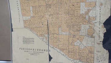 Peterborough History Group
Map - Map of the Parish of Nirranda, Parish of Nirranda
... Maps ...Map of the Parish including roads, names of landowners, location of schools etc in 1939A3 size map of the Parish of Nirranda in 1939nirranda, maps, parish map -
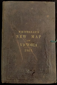 Kew Historical Society Inc
Map, Whitehead's Map of Victoria, With Alphabetical Key, 1869, 1869
When E. Whitehead's New Map of Victoria was released in 1869, an advertisement in the Bendigo Advertiser (16 July 1869) noted that: "This beautifully engraved Map has been revised and brought down to the present time; and, with the Alphabetical Key, is the most complete and the cheapest Map ever published; Price, 6d plain; 1s colored; 2s 6d in case; on linen, post free, 2d extra. E.. WHITEHEAD and CO, Publishers, 67 Collins-street east." The following year, 1870, Whitehead's promoted the edition in the Portland Guardian and Normanby General Advertiser (3 January 1870), advising that: "WHITEHEAD'S NEW MAP OF VICTORIA, 1869 ... is corrected to the latest date, and around is arranged an Alphabetical Key, with Post Towns and Money Order Olffices marked. The Map being divided into squares and numbered, by reference to the Key any place can be found immediately. Price Is beautifully colored, or mounted on linen in case, 2s 6d. Post free, 2d extra, in Victoria. B. Whitehead and C0., Puolishers, 67 Collins-street East, Melbourne". In the same edition of the Portland Advertiser, they also promoted their business generally, saying: "E WHITEHEAD and Co., Stationers, Engravers, Lithographers, 67 Collins street East, execute every description of Lithographic PRINTING, BILL-HEADS. NOTE Headings. Business Dies Engraved and Embossed on Envelopes &c. ARMS, MONOGRAMS, AND CRESTS Engraved and Embossed in Colour, superior to any other house in the Colony. Specimens, post free, 2d. Lithographers, &c, to H.R.H. the Duke of Edinburgh, and Die-inkers and Embossers to His Excellency Sir J. H. T. Manners-Sutton, K C.B. Orders executed for the Trade". Whitehead’s New Map of Victoria 1869 is is an important record of region created towards the end of the Victorian Gold Rush (1851-1869). In addition to its historical significance, this is a rare map, of which the only known copies in Australian public collections are those held at the National Library of Australia, the State Library of Victoria, State Library of New South Wales and the University of Queensland Library.Map of Victoria with gold mining areas, notes on topography, transport routes. Relief shown by hachures. List of towns with distance from Melbourne in map margin. [Melbourne] : Printed & Published by ... E Whitehead & Co ... 67 Collins Street East, 1869 1 map : col., mounted on linen ; 38.4 x 55.4 cm, folded to 18 x 12 cm.Cover "WHITEHEAD'S NEW MAP OF VICTORIA 1869"maps - victoria - 1860s, e whitehead's new map of victoria 1869, whitehead's map of victoria with alphabetical key 1869, cartography, gold rush -
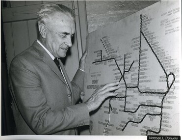 Vision Australia
Photograph - Image, Ron Bruce reading Sydney Train map, 1971?
... Maps ...Ron Bruce reading a Braille map of Sydney's railway network.B/W photograph of man reading braille map1/71016 M&O -historicalroyal blind society of nsw, ron bruce, maps -
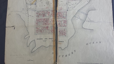 Peterborough History Group
Map - Map of the town, Government Printer, Township of Peterborough
... maps ...Map donated by Barry Jenkins and assume that updated names were written on the map by him. Good information pertaining to the history of each allotment. Significant as it shows the names of the owners of each allotment in 1931 and handwritten notes of more recent owners.27/6/1931 paper map of the township of Peterborough including names of the landowners at that time.Handwritten landowner names over the original printed names.peterborough, old maps, maps -
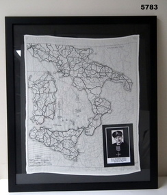 Bendigo Military Museum
Map - MAP, ITALY, SILK, 1939 - 45
... maps ...The silk maps were carried by Aircrew. This item carried by A.F. Goodall DFC, RAAF, refer Cat No 543.2 for his service details.Framed silk map of Italy and Sicily, black frame with black backing, map is in all black, the other side shows Northern Italy, inset is a photo of A.F. Goodall DFC, RAAF.silk, maps -
 Vision Australia
Photograph - Image, Ron Goodwin reading a map of Wynyard train station, 1969?
... Maps ...Ron Goodwin reads a tactile map of Wynyard Railway Station in Sydney's CBD. The map was made at the Sydney Tesol College with wood working machinery and painting/decorating sections. In front of Ron sits a ultrasonic torch.B/W photograph of man looking at relief map of Wynyard Station14/69051 Ann. Report Orientation - historicalroyal blind society of nsw, ron goodwin, maps -
 Whitehorse Historical Society Inc.
Map - Civic Map, Subdivision of Village of Springfield, 1861
Map of the subdivision of the Springfield Estate, Nunawading, 1861. The Springfield Estate was located in the Northwest corner of Whitehorse Road and Springvale Road.Map of the subdivision of the Springfield Estate, Nunawading, 1861. Springfield Estate was located in the Northwest corner of Whitehorse Road and Springvale Road.non-fictionMap of the subdivision of the Springfield Estate, Nunawading, 1861. The Springfield Estate was located in the Northwest corner of Whitehorse Road and Springvale Road.springfield estate, whitehorse road nunawading, springvale road nunawading -
Whitehorse Historical Society Inc.
Map, Nunawading Planning Scheme. Local Section, 1993
... Maps ...Map of City of Nunawading.Map of City of Nunawading showing zoning of areas by means of colours and some detailed designations. Note: ' This map contains amendments as at 14 Oct 1993'Map of City of Nunawading.city of nunawading, maps, land use -
 Ballan Shire Historical Society
Map - Map. Ballark, Department of Lands and Survey, Ballark. County of Grant, 31/08/1915
A map of the Ballark area within the County of Grant showing roads, waterways, property boundaries and property owners in 1915.Significant to people researching land usage and ownership. Also those researching families in the area at that time.A map of Ballark in the County of Grant. Black printing on buff coloured paper. Extra notations by hand and various coloured highlighting of certain features. Details roads, rivers, property boundaries and names of property owners and districts. The map is easily readable although there is some physical damage to the borders and some sellotape residue. Shows a scale in Chains and the number L.6030Various numbers and directional arrows added to map.bungal, borhoneyghurk, bungeeltap, ballark, beremboke, moreep, meredith, morrisons, moorarbool river -
Melbourne Tram Museum
Map - Metlink folder - Travel Smart Maps, Travelsmart - Department of Infrastructure, "Melbourne's Public transport Map", 2005 to 2006
... maps ...Set of four maps issued by Metlink - 2005 to 2006 contained within a Metlank badge plastic folder. Maps published in association with Melway 1 - 5 x 8 fold map with card cover dated Jan 2005 with a price of $2. Detailed map showing rail, tram and bus routes. 2 - 6 x 4 fold map for Moonee Valley - Travelsmart - for public transport, walking and cycling - dated 2005 3 - 7 x 4 fold map for Moreland - Travelsmart - for public transport, walking and cycling - dated October 2006 - includes notes on taxis. 4 - 7 x 4 fold map for Ride to Work day - 5 Oct. 2005Yields information about Melbourne Public Transport network.Metlink plastic folder containing maps.maps, metlink, public transport, moreland, moonee valley, travelsmart