Showing 2475 items matching " township"
-
 Bendigo Historical Society Inc.
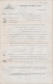
Document - H. A. & S. R. WILKINSON COLLECTION: CONTRACT OF SALE
Contract of sale of land dated 7th January 1952 between Mr. H. & Mrs. E. M. Muir (vendor) and Mrs. R. F. Turvey (purchaser). Property: land being allotment 118B section D in the Township of Kangaroo Flat Parish of Sandhurst County of Bendigo, containing 1 rood 38 perches and 1/10 of a perch land described in Crown grant volume 7454 folio 004 and situate in Railway Terrace, Kangaroo Flat, together with 5 roomed weatherboard dwelling and all sundry outbuildings, also all blinds and electric light fittings and shades. Price 875 pounds.organization, business, h.a. & s.r wilkinson real estate -
 Ballarat Tramway Museum
Document - Report, State Electricity Commission of Victoria (SECV), "Commission Acts and Regulations", May. 1958
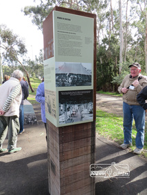
Twenty two page document, outlining the Acts and Regulations of the State Electricity Commission of Victoria with an introduction, dated 28 may 1958. Gives background to the Electricity Commissioners Bill of 1918, SEC ACTS, General Powers and responsibilities, SEC ACT of 1929, which allowed for operation of Tramways, and associated provisions and powers, Yallourn Township, Tramways By-Law No. 1, Orders in Council for local councils to supply power and wiring rules etc. Printed by a duplicating process onto paper with rounded corners. Pages held in top left hand corner by a brass split binder. Pages have "sticky tape" repairs on edges.On top of the first sheet in ink "Received from o/m in December 1958"trams, tramways, sec, acts of parliament, power supply, tramways -
 Bendigo Historical Society Inc.
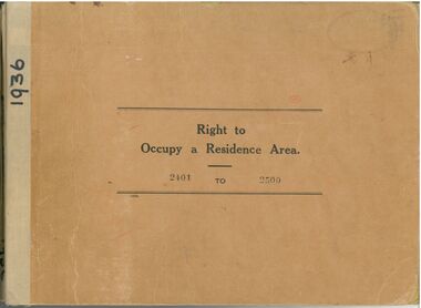
Administrative record - Right to Occupy Certificates
Ten books containing stubs of Right to Occupy Certificates for 1936. Includes name and address of person receiving the Right to Occupy certificate and the description of the land including allotment, Section, City, Town, Borough or Township and Parish name. Two blue covered books used for Substitute Right to occupy certificates. One book, stubs only, dated 1976 - 1981. One with four stubs dated 1981 - 1983. Four stapled bundles of stubs dated 1937 - 1971 issued for Replacement Rights. Includes names and Receipt numbers. Yellow foolscap sheet Listing reord numbers of Rights issued during 1936 and 1937.Some items have pencil and pen marks and ink stains.right to occupy, central victoria -
 Federation University Historical Collection
Book, Final recommendations Ballarat Study Area Land Conservation Council, Victoria, 1982, 1982
Yellow soft covered report of 95 pages . The contents of the report include: Parks, reference areas, wildlife reserves, water production, hardwood production, softwood production, flora Reserves and Flora and Fauna reserves, bushland reserves, historic area and reserves, rivers and streams, Roadside conservation and Highway parks, Education areas and School Plantations, Lake Reserves, geological reserves, recreation, scenic reserves, agriculture, mineral and stone production, utilities and survey, township land, Uncommitted Land, military training, other reserves and public land. Maps include: The Study area 1: 250 000 Supplementary Mapsland conservation authority, ballarat, endowment plantations, pine plantations, langi ghiran state park, mount buangor state park, enfield state park, ballarat-creswick regional park, rossbridge, black lake, flax mill swamp, dereel lagoon, lake bolac, lake wongan, langi ghiran reservoir, gong gong reservoir, pincotts reservoir, beales reservoir, wilsons reservoir, moorabool reservoir, korweinguboora, korweinguborra reservoir, learmonth bores, sago hill, illabarook reservoir, ballarat water commission, dunneworthy, mount cole, mont lonarch, ben major, waterloo, trawalla, linton, ross creek, canadian, shepherds flat, lal lal, mount doran, raglan, chute, carngham, buninyong, watsons hill, enfield, cape clear, illabrook, rokewood junction, mount warrenheip, nerrina, jubilee, golden stream, australasian deep lead mine, happy valley school, piggoreet, berringa, bulldog, ballarat common, wildlife, water, timber, flora, rivers, geology, agriculture, warrenheip, biodiversity -
 The Beechworth Burke Museum
Photograph
This photograph was taken of an avenuw of acacias on Sydney Rd, Beechworth. Picture on the left hand-side is a row of Liquidamber trees also known as American storax, hazel pine, bilsted, redgum, satin-walnut, star-leaved gum, alligatorwood, or simply sweetgum. On the right is a row of English Oak trees commonly known as common oak, pedunculate oak, or European oak. Behind the English oaks is Old Beechworth Goal. Many of the trees in the Beechworth township were planted in the 1860's and today have exceptional historical, botanical or cultural value. Their place within the built environment reflects the importance in the Victorian era of town planning for a community, wealthy in gold and civic pride.Black and white rectangular photograph. The image is printed on gloss photographic paper and mounted on cardboard. Obverse: NO INSCRIPTION Reverse: 7760 The old Acacia Avenue alongside the jail. Sydney Road Beechworth Gardens & Parks beechworth, acacia avenue, gaol, sydney road, burke museum, photograph, post card, english oak, liquidambar -
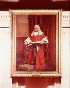 Supreme Court of Victoria Library
Portrait, Sir William Stawell
The portrait was commissioned in 1884, near the end of Stawell's term of office. The portrait was commissioned at the same time as those of Redmond Barry and Justice Molesworth. The total cost of all three paintings was 1200 pounds. Sir William Stawell arrived in Victoria in 1842; he quickly established a reputation for himself at the Bar. After the separation of the Port Phillip colony from New South Wales, Sir William served as the attorney general in the first representative government and was the leading prosecutor in the Eureka trials. Sir William was appointed as Chief Justice of the Supreme Court in 1857, serving 29 years in the post. In addition the township of Stawell was named after the recently appointed Chief Justice in 1858. The portrait is of historical significance as a portrait of Sir William Stawell.Full length portrait in oils of Sir William Stawell. Stawell is seated and dressed in his judicial robes. Signed and dated 1887 lower right hand corner of the painting. Plaque identifying subject. The Hon. Sir W.F. Stawell.K.C.M.C Chief Justice of the Supreme Court 1857-1886judges, william stawell -
 Eltham District Historical Society Inc
Document - Property Binder, 963 Main Road, Eltham
Newspaper article: Big crowd sees Eltham P.O. openingThe News, 31 January 1958, Opening of new post office in Eltham. Program of proceedings: Official Opening of the new Eltham Post Office by Mr D C McKenzie M.P. Friday 14th February 1975. Typescript: A History of P.M.G. Services at Eltham, prepared by Derek M Baker, Post Office Historian-Victoria, 1975, including Chronology, text, list of Sources. Sheet of proceedings: Official Opening of the new Eltham Post Office including Historical Notes. Newspaper article: Diamond Valley News, 2 July 1985, Gold brought life to the township. main road, eltham, businesses, eltham post office, e p harmer, d c mckenzie m.p., w j b pollock, a s knox, senator a j missen, derek m baker, australia post, peter jolly -
 Kiewa Valley Historical Society
Black and white photograph of farmland, Kiewa, 25/8/38, circa 1938
This photograph was taken in August, 1938, some eight years prior to the establishment of Mt. Beauty a a township. The area was still being used for grazing, and the land was eventually acquired from the local land owners by the State Electricity Commission. The construction of the road, from Tawonga to the High Plains, was commenced in April, 1938 and this photograph was taken August, 1938. This allowed men and heavy equipment to be transported to the work sites for the construction of the Kiewa Hydro Electric Scheme. Prior to this access was by bridle trail, either on horse back or on foot. By 1946 housing construction had commenced for the new town of Mt. Beauty and by 1948 street construction in the southern part of the town was completed as far as Hill Street.This photograph is important as it shows the upper Kiewa Valley as it was before the establishment of the town of Mt. Beauty. The land has been cleared of natural vegetation to allow grazing of cattle. Black and white photograph of grazing farmland with one animal standing in the paddock. The area could possibly be where the golf course now stands with the road to the high plains not yet commenced.Handwritten in the upper left hand corner 'Kiewa 25/8/38'. The number 7 has been stamped in the upper right hand corner. It is part of a set of 8 photographs. On the back are the words Velox repeated several times, indicating the type of photographic papergrazing, kiewa, mt. beauty, secv -
 Kiewa Valley Historical Society
Photograph Farm Land, Kiewa, 25/8/38, circa 1938
This photograph was taken in august, 1938 some eight years prior to the establishment of Mt. Beauty as a township. The area was still being used for grazing cattle and the land was eventually acquired from the local land owners by the State Electricity Commission. The construction of the road, from Tawonga to the High Plains, was commenced in April of 1938. This allowed men and heavy equipment to be transported to the work sites for the construction of the Kiewa Hydro Electric Scheme. Prior to this access was by bridle trail, either on horse back or by foot. By 1946 housing construction had commenced for the new town of Mt. Beauty and by 1948 street construction in the southern part of the town was completed as far as Hill Street.This is an important photograph as it shows the upper Kiewa Valley and the site for Mt. Beauty as it was before the establishment of the town. The land has been cleared of natural vegetation and used for grazing cattle.Black and white photograph of farmland, cattle in the distance, hills in the backgroundHandwritten in the upper left hand corner, in black ink, 'Kiewa 25/8/38'. The number 8 has been stamped in the upper right hand side of the photograph. On the back have been stamped the words Velox, indicating the type of photographic paper.kiewa, mt. beauty, construction, grazing, secv -
 Eltham District Historical Society Inc
Photograph, Shire of Nillumbik World War One Memorials tour, 10 August 2016, 10 August 2016
As part of a program to acknowledge the Anzac Centenary Nillumbik Shire Council partnered with Yarra Plenty Regional Library to provide a bus tour with commentary of local sites of significance. These included Eltham township, the Shire of Eltham War Memorial at Kangaroo Ground, Christmas Hills war memorial, Hurstbridge memorial recreation park and finshed at Eltham Library to view the Writing the War exhibtion at Eltham Library Community Gallery. In May 2015 Nillumbik Shire Council received Anzac Centenary Local Grants Program funding for the restoration and enhancement of the Christmas Hills cenotaph as a project to commemorate the First World War An interpretative project lists names on the honour roll for Christmas Hills and District Born DigitalChristmas Hills and District Honour Roll World War 1 1914-1918 Lest we forget Arthur Stanley Ashmore James Edward Betts Herbert Eugene Borner Harry Conway* George Benjamin Muir Henry (Harry) Thomas Muir George Peter Maurice Saltau George Edwin Smith James Henry Sumner John Valentine Wilson* *Killed in actionworld war 1, war memorials, shire of nillumbik, christmas hills, interpretative signage, list, names, honour roll -
 Eltham District Historical Society Inc
Photograph, Shire of Nillumbik World War One Memorials tour, 10 August 2016, 10 August 2016
As part of a program to acknowledge the Anzac Centenary Nillumbik Shire Council partnered with Yarra Plenty Regional Library to provide a bus tour with commentary of local sites of significance. These included Eltham township, the Shire of Eltham War Memorial at Kangaroo Ground, Christmas Hills, Hurstbridge memorial recreation park and finished at Eltham Library to view the Writing the War exhibtion at Eltham Library Community Gallery. In June 2014 Nillumbik Shire Council received Anzac centenary Local Grants Program funding to create new interpretative signage that acknowledged the history of the Hurstbridge Memorial Recreation Park as a memorial to all who served in the First World War. One of the panels discusses women. Born Digitalworld war 1, war memorials, hurstbridge, interpretation panel, interperative signage -
 Warrnambool and District Historical Society Inc.
Document, Warrnambool Tramways-William Bell, C 1881
In 1858 a tramway was constructed to move goods between Warrnambool township and jetty on Lady Bay which was over a mile away The terminus was established on the southern side of Merri Street. and the track went around the edge of Lake Pertobe reserve. Large stores were also built near where the present railway station is situated to hold produce and carriages.This document is is a surety between John McDermit a saddler of Liebig Street Warrnambool along with Henry Phillips hay and corn dealer of Liebig Street Warrnambool, acting as surety in the amount of fifty pounds to William Bell a contractor to perform horse work for the Warrnambool tramways. for a period of one year, 1881-1882. This contract has a strong historical link to one of Warrnambool's earliest infrastructure projects . It contains the names of local people and provides an insight into the links between people and the types of work they undertook Pale blue lined paper with red lined outline.Hand written in black pen with names and some other words underlined in red. Two signatures on bottom right with red seal beside each. Witness signature below on left hand side. Of the four pages of the document , only the first page is used.Signed John McDermid, Henry Phillips. 1st October 1881.warrnambool,, warrnambool history, warrnambool tramways, william bell contract,, john mcdermid, henry phillips -
 Sunbury Family History and Heritage Society Inc.
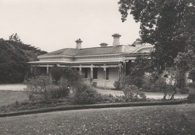
Photograph, 'Glenara' Homestead, 20 August 1952
"Glenara' was the home of Alistair Clark who lived at Bulla which is situated about 20 kms NW of Melbourne in the Deep Creek valley. He was born there in 1864 and lived there throughout his lifetime until his death in 1949. His father established the property during the mid-nineteenth century. Alister Clark was a rose grower and created the very popular 'Lorraine Lea 'rose along with other famous species. A rose garden has been established in the township of Bulla in his memory. He was also an active member of the Victorian Racing Club. The original photograph was published in the Melbourne 'Herald' on 20 August 1952 on page 5.Alistair Clark was a prominent rose grower and developed many rose species which were suitable for Victorian conditions. The homestead is a good example of Victorian architecture built in Victoria in the latter years of the nineteenth century. The house has a heritage listing in the City of Hume Heritage Study.A black and white photograph with a fine white frame, of a Victorian homestead with a a verandah across the front of the house. It is set in a spacious garden with garden beds, lawn and trees.clark, alistair, 'glenara' homestead, roses, bulla, deep creek -
 Wodonga & District Historical Society Inc
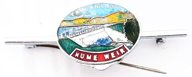
Souvenir - Tallangatta - Hume Weir Tiepin, 1980s
A wide range of items have been created as souvenirs to represent the Hume Weir on the Murray River. Work on Hume Dam started in 1919 and took 17 years to complete. Souvenir items have included chinaware, ashtrays, placemats and small jewellery items such as this tie pin. This tie pin was created as a souvenir for the town of Tallangatta. In the 1950s, the height of the Hume Weir wall was increased, resulting in a nine metre rise in the level of the water in Lake Hume. This necessitated the moving of most of the town of Old Tallangatta due to flooding. The transfer of the township by the State Rivers and Waters Supply Commission to a new site approximately 8 kilometres to the west was completed on 29 June 1956.This item is representative of many items commemorating the Hume Weir and the township of Tallangatta.A small metal and enamelled oval tie pin. It features and image of the Hume Weir.Around top edge in white: TALLANGATTA Around bottom edge" HUME WEIR"hume weir australia, tallangatta, tallangatta - the town that moved -
 Wodonga & District Historical Society Inc
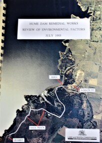
Booklet - Hume Dam Remedial Works - Review of Environmental Factors July 1995, Department of Land and Water Conservation, NSW Government, July 1995
The findings of a review into the environmental impact of remedial works being carried out on the Hume Dam.non-fictionThe findings of a review into the environmental impact of remedial works being carried out on the Hume Dam.hume dam, remedial works dams, environmental impact of dams -
 Linton and District Historical Society Inc
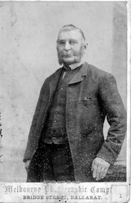
Photograph, Melbourne Photographic Company, Bridge St, Ballarat, Mr W.G Bennett, butcher
William Garnsworthy Bennett was at Linton's Diggings in 1856, when he married Susan Williams. Both had migrated from England. W. G. Bennett established a butcher's shop in Linton Township, and later purchased farming land and other town allotments. William and Susan Bennett had twelve children, eight of whom survived to adulthood. W. G. Bennett was a Trustee of the Linton Town Common, was elected to the Grenville Shire Council in 1871,and founded the Linton Rifle Club. After W. G. Bennett's death in 1903, the butcher's shop was run by the Todd family. William and Susan's daughter Elizabeth (Lizzie) married William Todd in 1882.Sepia photograph of a gentleman with long sideboards, moustache and beard, wearing a suit."Mr W G Bennett, Butcher"william garnsworthy bennett, w. g. bennett [butcher] -
 Stawell Historical Society Inc
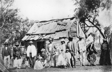
Photograph, Indigenous or First Nations People at Carrs Plains 1874 Richardson River Tribe
Photo taken at Carrs Plains in 1874 of Indigenous or First Nation People outside a wood and bark hut. In 1861, William Dennis of Carrs Plains Station, a staunch Methodist became Honorary, Aboriginal Protector for the area. One of his main tasks to give Government supplied food and clothing to the Aboriginals. Many district, remaining Aborigines became based at Carrs Plains, and their dead were buried in a cemetery on the station. The cemetery is show on survey map of Wirchilleva Borough, in corner of camping & water reserve near surveyed Bismarck township. In a Protector's report 1869, Dennis wrote that only one male worked regularly on the property, a Bullock driver.Black and white photograph of a wood and bark hut with a group of men, women and children out the front. Richardson River Tribe.Anthony & Lubra, Donald & Affie my ? Herbal? Black Billie Great Rider, Kitty Supulants? Lubra Jonny Callaghan Jr., Four? Supulant? Harry, Blind Tommy & Lubra, 1874 Reproduction rights reserved Copied by State Library of Victoriastawell aboriginal portrait -
 Kiewa Valley Historical Society
Photos: Kiewa Hydro Electric Scheme x 12
K.H.E.S.Photos 4 coloured and 8 black and white with the Title printed below each one. 1. S.E.C.V. Telephone Switch Board (See also KVHS 0847) 2.West Kiewa Tunnel 3. Construction of Underground Power Station 4. Pretty Vally Camp 5.Outside Kiewa House, Bogong 6. S.E.C.V. Saucer (See also KVHS 0128) 7.Insulator Disk Struck by Lightning 8. S.E.C.V. Map of the Kiewa Hydro Scheme 9.Howman's Gap Camp 10.Tunnel Excavation Face 11. Mt Beauty Townhship 1948, looking north east 12. Mt Beauty Township - no labelkiewa hydro electric scheme photos -
 Bendigo Historical Society Inc.
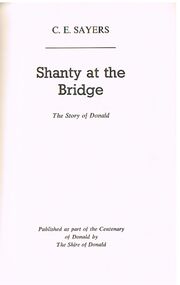
Book - ALEC H CHISHOLM COLLECTION: BOOK ''SHANTY AT THE BRIDGE'' BY C.E.SAYERS
Book. ALEC H CHISHOLM COLLECTION. 233 hardcover book on the history of the Wimmera township of Donald, Victoria. Written by C. E. Sayers. Published in 1963 as part of the centenary of Donald by the Shire of Donald. Illustrated with B&W photos of the town and people. Printed by W & K Purbrick Pty Ltd, Melbourne. Catalogue sticker ''2230 SAY'' on spine. Handwritten in ink on the flyleaf ''A.H.C. From C.E.S. Sincerely September 1963'' On a loose page inside the front cover handwritten in ink ''Dear Chis Here it is for what it's worth I trust that the acknowledgement to R.A.H.S. Is considered O.K. Sincerely C.E.S. FirstPublished1963 (RAHS = Royal Australian Historical Society)C. E. Sayersbooks, collections, history, alec h chisholm collection, c.e.sayers, donald, wimmera -
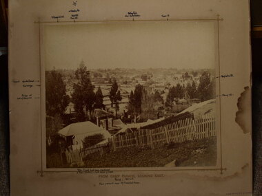 Clunes Museum
photograph, FROM CAMP PARADE, LOOKING EAST
PHOTOGRAPH OF CLUNES TOWNSHIP - FRASER STREET FROM CREEK PARADE, CLUNES. C1876 .1 BLACK AND WHITE MOUNTED ON CARDBOARDF .2 BLACK AND WHITE PHOTO PRINT .3 BLACK AND WHITE PHOTO PRINT .4 BLACK AND WHITE PHOTO PRINT .5 BLACK AND WHITE PHOTO PRINT .6 BLACK AND WHITE PHOTO PRINT .7 SMALL BLACK AND WHITE PHOTO PRINT .8 SMALL BLACK AND WHITE PHOTO PRINT .9 SMALL BLACK AND WHITE PHOTO PRINT .10 B LACK AND WHITE PHOTO PRINT .11 SEPIA MOUNTED PHOTO WITH POINTS OF INTEREST WRITTEN ON MOUNTING .12 SEPIA MOUNTED PHOTOlocal history, photography, photographs, clunes township -
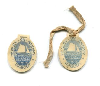 Orbost & District Historical Society
badges, 1918
The Henley on Snowy was a water carnival held on Saturday, 14th December, 1918. "It included a procession of decorated cars, buggies, etc., fancy costumes and sets, which left the township at 12.30. At 1 p.m. there was a speculator display of decorated boats. A luncheon, also afternoon tea and tea, was served by the ladies of the Red Cross, and the stalls were in the hands of the Comforts Fund girls." (ref Snowy River Mail 8.11.1919) Half of the proceeds were to go to the local Repatriation fund, the other half to be divided equally between the Y.M.C.A. and the Comforts' League. Unfortunately the carnival was not as successful as promised and the funds raised were not substantial. (More info. from O.D.H.S. May 2008 Newsletter by John Phillips)These badges are part of a historical local event. Two small paper Local Repatriation badges. They have a picture of a boat on the Snowy river and "Henley on Snowy- Orbost". 554.1 has a ribbon attached.henley-on-snowy water-carnival repatriation-funds -
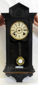 Orbost & District Historical Society
wall clock, c. late 19th century
The clock was the original clock located over the bar in the Orbost Club Hotel. In 1884 J.A. Petterson built the first Orbost Club Hotel with the licence in the name of Thomas Maguire (his stepson). This hotel was the first in the area and cost 1,400 pounds to build (ref. In Times Gone By - Deborah Hall) and was actually built before Orbost was proclaimed a township - April 17 1885 The R A on the pendulum stands for: retard/advance. It is a common pendulum bob, used by many manufacturers, worldwide. Regulator clocks, sometimes referred to as pendulum clocks, were invented in the late 18th century in a quest for greater timekeeping accuracy. They were weight-driven devices. The pendulum on this clock appears to be German made. .The Orbost Club Hotel was the first hotel built in the Orbost district and was an important hub for the township with many whole town meetings held there.A wall clock with Roman numerals inside a dark brown wooden case. It has a brass pendulum and the key is inside the case.R A on the pendulum.wall-clock orbost-club-hotel -
 Eltham District Historical Society Inc
Photograph, Shire of Nillumbik World War One Memorials tour, 10 August 2016, 10 August 2016
As part of a program to acknowledge the Anzac Centenary Nillumbik Shire Council partnered with Yarra Plenty Regional Library to provide a bus tour with commentary of local sites of significance. These included Eltham township, the Shire of Eltham War Memorial at Kangaroo Ground, Christmas Hills war memorial, Hurstbridge memorial recreation park and finshed at Eltham Library to view the Writing the War exhibtion at Eltham Library Community Gallery. In May 2015 Nillumbik Shire Council received Anzac Centenary Local Grants Program funding for the restoration and enhancement of the Christmas Hills cenotaph as a project to commemorate the First World War An interpretative project lists names on the honour roll for Christmas Hills and District with stories and photographsBorn Digitalworld war 1, war memorials, shire of nillumbik, christmas hills, interpretative signage -
 Warrnambool and District Historical Society Inc.
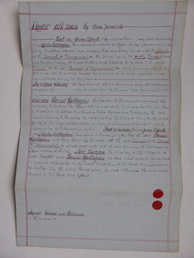
Document, Gallagher, C 1881
In 1858 a tramway was constructed to move goods between Warrnambool township and jetty on Lady Bay which was over a mile away The terminus was established on the southern side of Merri Street. and the track went around the edge of Lake Pertobe reserve. Large stores were also built near where the present railway station is situated to hold produce and carriages. These documents relate to the contract to perform the horse work for the tramway for a period of one year. The horse work involved the transporting of goods by horse drawn tram trucks, all repairs to the tracks , shunting and delivery duties. The tramway operated from 7 am to 6 pm six days a week and a team of six horses was required to perform the work.The tramway was an important part of Warrnambool's infrastructure and history and the documents also include names of local people.001261.1 Pale blue lined paper with red lined outline.Hand written in black pen with names and some other words underlined in red. Two signatures on bottom right with red seal beside each. Witness signature below on left hand side. Of the four pages of the document , only the first page is used. 001261.2 Cream paper lined in blue with heavy black ink writing. A red seal attached beside the tenderer's mark and name. on right side of page. Witness's signature at bottom centre of page.001261.1 James Roberts hay and corn dealer ,Fairy Street Warrnambool, Martin Callaghanfarmer and contractor Raglan Parade Warrnambool. Daniel Gallagher, contractor of Warrnambool. September 1881. 001261.1 Daniel Gallagher .James Roberts Martin Callaghan September 12, 1881.warrnambool, warrnambool history, daniel gallagher, james roberts -
 Orbost & District Historical Society
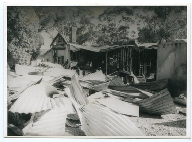
Photograph - Bemm River hotel fire
Bemm River is a small township in East Gippsland. There have been several Bemm River hotels since 1891 when the first Hotel was built by Henry Summer. This Hotel was located near a ford where traffic crossed the river. Annie Morgan was the next person to have a roadside licence to sell liquor at Bemm River, also known as Sydenham Inlet Hotel. In 1927, a hotel was built on the present site at Bemm River, again with the Morgan family. Like many hotels, the Bemm River hotel has burned down or suffered damage through fires and was rebuilt. These photos are likely of a fire at the Hotel in 1994 which resulted in the hotel burning down. It was re-built in 2000 on the same site.History of Bemm River and its hotel5 b/w photos showing a building with severe fire damage, and two people in front of the photos (probably owners).nonebemm river, fire, hotels -
 Flagstaff Hill Maritime Museum and Village
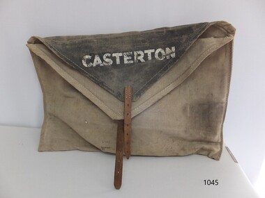
Functional object - Courier Bag, Government of Victoria, Late 19th to mid-20th centuries
The courier bag was once government property, as indicated by the broad arrow symbol. The flap has the name 'Boronia' - an area near Melbourne - overstamped with the town name 'Merino', and on the other side of the flap is the town 'Casterton'. Merino and Casterton are renowned for large sheep farming properties in Victoria's western district. Perhaps the courier bag was originally used between Melbourne and Boronia. During the late 19th and early-to-mid 20th centuries, a government-operated railway service was active in in the western district of Victoria. It served remote properties, including a line between Merino and Casterton. The train delivered mail, cash, supplies documents, business records and people between the sheep farm properties and the township of Casterton.This courier bag is an example of the connections and business between people in the remote areas of western Victoria. It was likely used by Victoria's railway system that transported people, goods, documents and cash between the districts of western Victoria.Courier bag; beige canvas rectangular bag with triangular black canvas flaps and a leather strap and buckle closure. The bag has stencilled stamps of three towns - Casterton, Merino and Boronia. It also has the government property symbol of a broad arrow.White stencilled paint "CASTERTON" Black stencilled paint "BORONIA" [barely visible] White over-stamped stencilled paint "MERINO"warrnambool, shipwreck coast, flagstaff hill, flagstaff hill maritime museum, flagstaff hill maritime village, bag, pouch, document pouch, courier bag, western district, western victoria, 19th century, 20th century, railway, rural business, rural trade, boronia, casterton, merino, sheep farm, sheep property, canvas bag, canvas courier bag, government courier bag, broad arrow -
 Creswick Museum
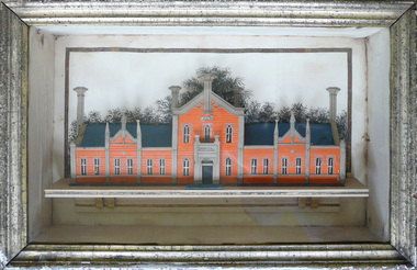
Model Building, circa 1869
Rev. Thomas Williams was grandfather of the Lindsay children. He is credited with encouraging his grandchildren in their artistic talents. Both Lionel and Normam learnt their model making skills from him. Creswick Hospital was foundation stone was laid in 1863. It operated as a hospital until 1911 when it was sold to the government as part of the School of Forestry (now University of Melbourne). The model shows it as a red brick building. In the 1870s it was painted as a white building. The Museum has b/w photos of the building taken prior to rendering. The people of Creswick collected fund for the project and obtained a government grant. The 1857 survey map of the proposed township shows the area at Eastern Hills reserved for a hospital and Benevolent SocietyThe model's unique association with the Lindsay Artist of Creswick. Model of Creswick Hospital before rendering. Made of paper with painted background and framed.model, creswick hospital, rev t. williams, lindsay family -
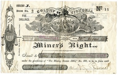 Flagstaff Hill Maritime Museum and Village
Ephemera - Miner's Right - Collins, 1888
This Miner’s Right was issued post the rush of the 1850s-60s but is testament to the ongoing interest in gold although the great rush had dwindled. Local papers continued to report on findings and hopes of success, including syndicates and explorations across the south-west district of Victoria and Otways. The Warrnambool correspondent of the “Hamilton Spectator”, 31/1/1878, p4 attest to the price of a good season of potatoes comparing “favourably with the unsteady returns of any precarious gold-bearing quartz reefs in the colony.” A James Collins (1842-1918) is listed in the Pioneers’ Register, Warrnambool, Township and Shire 1839-1900, Volume One, A.I.G.S Warrnambool Branch, 2004, p137. As are numerous other Collins pioneer families of the district. This item is significant in that it illustrates that people associated with the region were interested in taking their chances in prospecting for gold similar to many others. A lure that is still present for some today. Although the southwest region found it's source of wealth in other industries from whaling and fishing, wool and other agricultural pursuits. This is a top to bottom upright image of a Miner’s Right. It is a buff coloured document printed in black ink. It was issued in “BALLARAT” and rubber stamped twice in red ink. The issue to “James Collins”, is dated “23rd August 1889” to “22nd August 1890”. The signature of the authority could be Bennet. All handwriting is script style in black ink. Looking from the front the lefthand side has a serrated edge. The back is printed in black ink and there are no “particulars of registration”. The Miner’s Right is from “Series J, Book No. 3, ticket “No. 15”. A “Colony of Victoria” coat of arms is displayed at the top of the document. An insignia runs along the lefthand side of the license featuring coat of arms with a kangaroo and emu, then a miner’s pick and shovel, two crossed Union Jack flags sit behind a monogram “VR” with a hanging set of scales supported by a sword. "By Authority Robt. S. Brain, Government Printer.""Series J. Book No. 3 Five Shillings. No. 15. Colony of Victoria. Miner's Right"flagstaff hill, warrnambool, shipwrecked coast, flagstaff hill maritime museum, maritime museum, shipwreck coast, flagstaff hill maritime village, great ocean road, james collins, australian goldfields, miner's rights, the history of ballarat, gold rush -
 Phillip Island and District Historical Society Inc.
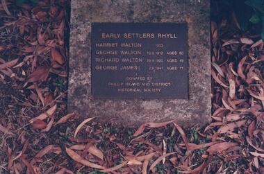
Photograph Album, Kodak, Phillip Island Cemetery, c 1990
The Album was compiled by Nancy McHaffie late 1990's, with the assistance of Edith Jeffery's, with her book "Garden of Memories" and extensive knowledge of Phillip Island. The Cemetery lies back from the road and is surrounded by Manna Gums, rare Peppermint Gums, Blackwoods and other native trees. In all 25 acres of land were set aside as Crown Land in the land settlement of 1868. There are 6.2 acres of wetlands near the cemetery entrance.466-40: George Walton settled at Rhyll after the Land Settlement Act was granted 8 acres in the township of Rhyll. He was the father of a large family, many descendants still live on Phillip Island. He had the honour of being the first brickmaker on the Island. He died in 1912 in his 81st year. Also Harriet Walton, Richard Walton & George James. 466-41: The Gall Family. Robert and Sarah Gall came to Phillip Island about 1869 and selected Block 10, some 20 acres. They built their home and sunk a well which still exists in Settlement Road, Cowes. Their Plaque and the Walton Plaque were donated by the Phillip Island & District Historical Society. phillip island cemetery, walton, gall, nancy mchaffie, edith jeffery -
 Ringwood and District Historical Society
Map - State Aerial Survey, Dandenong Ranges Area, Parishes of Warrandyte and Ringwood - 1956
Map of central and southern areas of Ringwood and part of Ringwood East and Heathmont compiled by Dept of Lands and Survey, July 1956, from aerial photographs and Cadastral Survey information. Subsequent hand-drawn addition of streets showing layout of "Township of Ballyduffy Estate 1858-60", an earlier proposed subdivision that did not eventuate. (See attached 5009b Ballyshanassy_ Melbourne’s lost suburb.pdf for Ballyduffy historical naming relevance). Ballyduffy Estate streets include City Road, West Prussia Road, Duffy Street, Ireland Street, Evans Street, Victoria Street, Regina Street, Short Road, Prussia Road, Duffy Street East, Ireland Street East, Evans Street East, Chapman Street. Misc Topo 93 Sheet 22, Ringwood A4B2. Scale: 4 chains to 1 inch. Contour interval 20 feet.