Showing 1821 items
matching brick building
-
 Kew Historical Society Inc
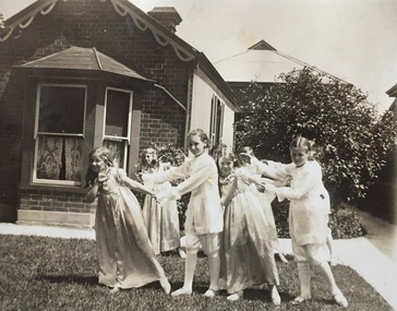
Photograph - Clarence Kindergarten and Sub-Primary, 180 Cotham Road, 1930-1935
180 Cotham Road, formerly 178 and later 210 Cotham Road, described as a brick residence of six rooms, was constructed in c.1890, for Alexander Hall, a dentist. From 1903, Miss Florrie Wymond operated a girls school at the property, and a timber schoolroom building was constructed at the rear of the property. During the 1930s, the school was known as the Clarence Primary School, and operated by Misses F L and M Wymond. While the listing of the property as a primary school had ceased by 1947, the Wymond family owned the property until the mid 1960s. (Source: Lovell Chen 2007, Review of B-graded buildings in Kew, Camberwell and Hawthorn).One of three photographs taken between 1930 and 1935 of students of 'Clarence' Kindergarten and Sub-Primary, located at 180 Cotham Road. The photos were accompanied by detailed notes identifying the names of students (where remembered).schools -- kew (vic.), clarence school, clarence house, 180 cotham road -- kew (vic.) -
 Kew Historical Society Inc
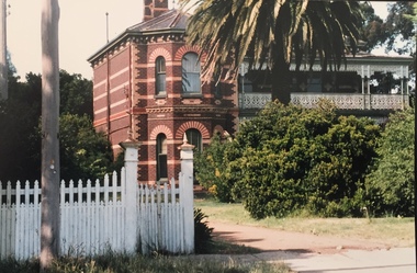
Photograph - Preshil (formerly 'Kalimna'), 12 Sackville Street, 1988
Documentary evidence records that in 1890 William H. Jarman, accountant, was the first owner and occupier of 'Kalimna', a substantial rwo-storey residence; it having an initial N.A.V. of £1503. In the following year the N.A.V. for the eleven-roomed property had increased to £2504 indicating that the building had been completed. Jarman is recorded as owning and occupying 'Kalimna' until at least 1910,Colour photographic positive of one of 'Kalimna'. The house is typical of the late Victorian period with polychromatic brick walls, a two storeyed, cast iron decorated verandah that spans two facades, and a polygonal bay window extending to the front. The eaves and chimneys are decorated with Italianate brackets executed in render. The slate roof remains intact, including its cast iron finials. (Kew Conservation Study, 1988)kalimna -- sackville street -- kew (vic.), preshil -
 Kew Historical Society Inc
Photograph - 'Glencara', 59 Sackville Street, 1988
The first documentary evidence of this house comes from Rate Books which record that in 1893 a Mrs Treadway was the owner of this building with an N.A.V. of £80. At that date the occupier of the house was Charles B. Kelly, a clerk, while by 1910 Kelly had become the owner of the property described in that year as a six-roomed stone, brick and wood house with stables and outbuildings.(Kew Conservation Study, 1988)Colour photographic positive of one of 'Glencara'. It is a single storeyed house clad in render and dominated by a verandah that wraps around the front and sides, following the line of the projecting polygonal bay window. The verandah has elegance, being supported on coupled candy-twist columns and decorated with cast iron, and it returns around to the side entrance. The slate roof is intact. (Kew Conservation Study, 1988)glencara -- sackville street -- kew (vic.) -
 Kew Historical Society Inc
Photograph - 264 Cotham Road, 1988
The dwelling is representative of the development of the Georgian Revival style in the 1920s and 30s and its popularity amongst the upper-middle classes as a result of the work of William Hardy Wilson and Professor Leslie Wilkinson. It is of importance as a fine and largely intact designer/builder example of the Georgian Revival style, with American Georgian Revival influences. The dwelling embodies the principal characteristics of the style. American Georgian Revival influences are noted in the deep eaves with modillions, central broken pediment, brick quoins and presentation of the central porch. The garden wall, with arched opening, in the side setback appears to be an early or original landscape feature, based on the comparable brick work detail construction with that of the house. Considering this, it is the only early landscape feature extant which assists in providing some understanding of the original landscape layout of the property. (Criteria D and E) (Boroondara Planning Scheme)Colour photographic positive of 264 Cotham Road, Kew. The residence was constructed in 1931 for the Howitt family. 264 Cotham Road, Kew (HO813) is an individually listed building of significance under Amendment C294 of the Boroondara Planning Scheme. 264 cotham road -- kew (vic.) -
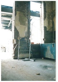 Queen Victoria Women's Centre
Photograph, August 1996
Colour photograph. Ground floor looking east formerly the administration offices into what was to be the cafe and in 2015 is the Breacan office. Ladder leaning against brick wall. Blue locked trunk left of frame, Taken during restoration inspection. historic buildings, building construction, cultural structures and establishments -
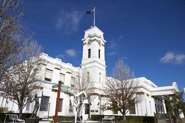 Glen Eira City Council History and Heritage Collection
Photograph - Building, Glen Eira Town Hall, 1884
Originally known as Caulfield Shire Hall, the original 1884 building was designed by Shire surveyor Sydney Smith. In 1931 the Caulfield Town Hall, as it was then known, was remodelled to include the main hall and foyer and a Neo-Grecian portico with Corinthian Order columns. Major works completed since 1945 include Caulfield Arts Complex (opened 20 August 1988), Caulfield Library (opened 4 December 1993) and the award-winning Caulfield Municipal Offices extension which opened on 24 February 1991. The building is listed as No. H0106 in the GECC Heritage Overlay Schedule. The site also includes a Significant Tree (H&H Register No. 034). Brick exterior of two storey building painted white and featuring pillared portico entrance and solid glass doors on Glen Eira road facing north. On the eastern side of the portico is a two storey clock tower with clock surmounted by a flagpole and flag. Some of the eastern section of the building is original with various alterations over the years. The award winning service centre and offices in the westerly aspect of the town hall were extended on to the original buliding in 2000.building, town hall, council, local government, caulfield, glen eira, moorabbin, sydney smith -
 Sunbury Family History and Heritage Society Inc.
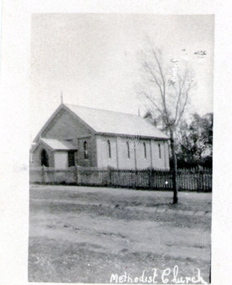
Photograph, Former Sunbury Methodist Church
... for the building of a new brick church on that site. The brick church... where in 1870 a small weatherboard building was built. In 1879 ...The church in the photograph is the former Methodist Church which is on the NW corner of Barkly and Harker Streets inn Sunbury. It was built on land donated by Thomas Woods at Lot 14 Barkly Street where in 1870 a small weatherboard building was built. In 1879 John Browning gifted land at 13 Barkly Street for the building of a new brick church on that site. The brick church continued to be a place of worship until the June 1977 when the Presbyterian, Methodist and Congregational churches came together and worshipped as the Uniting Church. St. Andrews Uniting Church have been the owners of this building since that time. A non-digital black and white photograph of a little Church building with the words Methodist Church written across the bottom of the image.methodist church, methodism, barkly street, harker street, uniting church -
 Sunbury Family History and Heritage Society Inc.
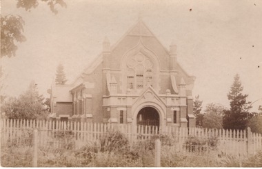
Photograph, St. Andrew's Presbyterian Church
The Government first granted land for the building of a Presbyterian Church in Sunbury in Stawell Street and Barkly Street, in 1864 and a smaller building was later erected on the site. In 1904 Rev Goyen pressed for a brick church rep[lace the smaller weather board building and the foundation stone was laid for the new church was laid by Mrs. John Duncan on 17th August 1904 and the new church opened by Lady Clarke on 13th November 1904.The Presbyterian Church was one of the earliest churches to be established in Sunbury along with a school.A non-digital sepia photograph in post card format of the front view of a brick church with a light picket fence across the front. -
 Sunbury Family History and Heritage Society Inc.
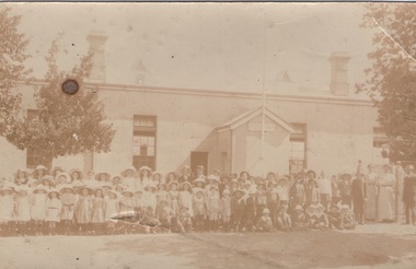
Photograph, Sunbury State School
The first building which housed Sunbury State School No.1002 was built on the corner of Macedon and Stawell Streets in the early 1870s and functioned as the local State School until 1912 when a sturdier red brick structure replaced on the same site. In 1999 Sunbury State School was relocated in the former Industrial School heritage buildings in Jacksons Hill. The existing building in Macedon Street was incorporated into the Sunbury Community Health Centre. The school in the photograph is the original Sunbury State School NO. 1002 building, where many early Sunbury residents attended. A non-digital black and white photograph in post card format of a crowd of children outside a school building. Four teachers are standing on the RHS of the image.sunbury state school no. 1002, stawell street, macedon street, schools -
 Sunbury Family History and Heritage Society Inc.
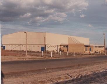
Photograph, c1980s
... A coloured photograph of a large colour bond building... building with a brick annex side at the entrance of a reserve ...The building in the photograph is the recently built stadium which is part of the Boardman Reserve Sporting Complex in Mitchells Lane. This complex caters for Australian Rules Football, basketball, netball and other community sporting activities for the Sunbury Community. The stadium was built during the 1980s when the town's population was on the increase.A coloured photograph of a large colour bond building with a brick annex side at the entrance of a reserve.boardman reserve sporting complex, australian rules football, basketball -
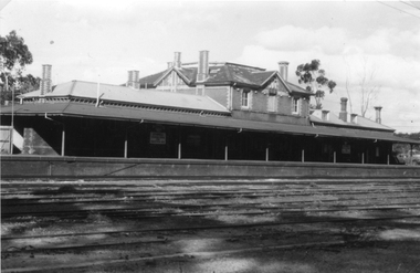 Stawell Historical Society Inc
Photograph, Railway Station Stawell
Railway Station Stawell. B/W photo showing large two storey brick station with long verandah over platform in heavy shade. Rail lines in foreground. This Photograph is a copy of a Negative owned by the Society - paid from a grant 1991. This Photograph is of Stawell Railway Station.B/W. Photograph of Stawell Railway Station taken from acroos the railway tracks. Also showing two vechiles of the far right. the centre of the building is two story stawell railways, transport, mark dadswell -
 Stawell Historical Society Inc
Photograph, Stawell Football Club Rooms at North Park -- old being demolished & new ones under construction 1991 & 2000 -- 15 Colour Photos
Club Rooms North Park 1991 & 2000 Demolition of old rooms and photos of erection of brick rooms.15 Colour photographs of building being demolished and erected,stawell -
 Stawell Historical Society Inc
Photograph, Second building used for the Weighbridge in Lower Main Street near War monument
... Second building for Weighbridge of Brick in Lower Main... grampians Second building for Weighbridge of Brick in Lower Main ...Second building for Weighbridge of Brick in Lower Main Street near War monument. stawell transport -
 Surrey Hills Historical Society Collection
Book, Raheen: a house and its people, 2007
Raheen is a 120 year old Victorian house owned by Richard and Jeanne Pratt. Mrs Jeanne Pratt commissioned the book and this copy was presented to Sue Barnett on a visit by members of the Boroondara Historical Societies. The visit was organised by local member Mr Josh Frydenburg. 92p. ill. bibliog., Raheen was a grand two-storey red brick house in the Italianate Style, with a prominent tower and an arcaded loggia on two levels. This book explores its history, restoration and further development over many years. 92p. ill. bibliog., Raheen was a grand two-storey red brick house in the Italianate Style, with a prominent tower and an arcaded loggia on two levels. This book explores its history, restoration and further development over many years.Endpaper: Surrey Hills Historical Society / Jeanne Pratt / 27/7/2013(mr) ian allen oam, (mr) william lawrence bailieu, ehud barak, (dr) james broadbent, (mr) robert bruce, (mr) george h w bush, (mrs) barbara pierce bush, (mr) arthur calwell, (ms) jane dennithorne, (mr) eamon de valera, (sir) james augustine gobbo, (mr) lloyd hill, (mr) william morris hughes, (lord) (mr) immanuel jakobovits, (mr) philip johnson, (cardinal) (mr) walter kaspar, moshe katsav, (mr) james robert knox, (mr) terence lane, (mr) edward latham, (mr) michael lehany, (dr) (mr) miles lewis, (mr) sam lipski am, (sir) (mr) thomas francis little, (mr) peter lovell, (mr) egidio lunardon, (mr) (cardinal) jean-marie lustiger, (mr) daniel patrick mannix, (sir) (mr) robert gordon menzies, (mr) henry miller, (mr) glen murcutt ao, (mr) benjamin netanyahu, (mr) ngo dinh diem, (mr) phillip nikolitsis, i (eoh) m(eng) pei, (mr) shimon peres, (mr) joseph reed, (mr) yves st laurent, (mr) william salway, (mr) james henry scullin, jessie serle, (mr) justin david simonds, (mrs) heliose waislitz, (miss) heliose pratt, (mr) john wren, (sir) (mr) henry john wrixon, (mr) richard pratt, (mrs) jeanne pratt, raheen, historical buildings, kew, victoria, italianate style, house names -
 Surrey Hills Historical Society Collection
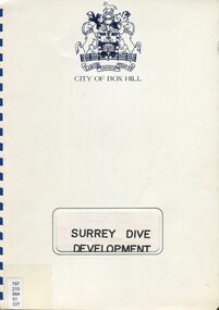
Book, Surrey Dive Development, Nov. 1986
A report on the proposed development of the Surrey Dive and adjacent areas. It includes topography, site services, buildings, usage of the area including fishing, boating, model boats.An A4 spiral bound report.surrey dive, box hill brick company, surrey park, shire of nunawading, scott and furphy engineers pty ltd, box hill -
 Surrey Hills Historical Society Collection
Photograph, St Stephen's Presbyterian Church, Surrey Hills, viewed from Warrigal Road, 1980's
The first service of the Surrey Hills Presbyterian Church was held at ‘Kinnoul’, the home of Thomas Hogg, located in The Avenue. This was while the church was being built. St Stephens Presbyterian Church opened in March 1899 on land that had previously been part of Klepper's orchard. The first minister was Rev F A Darling. He resigned in 1892 to open Surrey College. The church building pictured was built in 1910 adjacent on land gifted to the church. Noted features of the interior are the pulpit and honor board carved by sculptor John Kendrick Blogg. There are also memorial windows to Charles de Burgh Hogg and William Thomas Hogg, both killed in WW1.Red brick church with bell tower and slate roof. Cyprus tree at side; other trees fronting Canterbury Road.Canterbury Road - Warrigal Rd (written in biro on th back of photo)stained glass, lead lights, churches, presbyterian church, st stephens presbyterian church, 1980-1989, surrey hills, canterbury road, warrigal road, john kendrick blogg, charles de burgh hogg, thomas william hogg -
 Surrey Hills Historical Society Collection
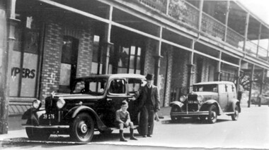
Photograph, Sunbury Crescent, Surrey Hills looking towards the corner of Union Road, 1930s, 1930
Date is approximate. This is one of a series of photos donated by Arthur Lyons. Lyons family history: Arthur's father, Fred Lyons initially worked for George Rea's cab service until he set up his own business. He started with a horse and hansom cab but in time he changed over to a motor vehicle and continued his service until 1960. Frederick Adolphus Lyons (1891-1980) was born in Surrey Hills, son of Thomas and Catherine Lyons. He married Elizabeth Ruby Hall in 1918. They lived at 55 Sunbury Crescent. The Lyons’ home in Sunbury Crescent was called ‘Knopshambury’ - this was probably a misspelling of Knockshanbally in Co Kilkenny, the birth place of Fred’s father, Thomas Edmund Josias Lyons (1846-1915). Arthur Lyons was born in Surrey Hills on 12 Jun 1920. He became a motor mechanic / welder and lived his whole life at 55 Sunbury Crescent. The donation was made while he was in hospital. He died shortly afterwards (23 Sep 1990). Donation was finalised by a neighbour, Mrs Florence Ann Armitstead, wife of Glen Victor Armitstead. Glen was a local hairdresser. They moved to 11 Sunbury Crescent after their marriage in 1939. Arthur had no relatives to distribute the material to. The buildings date from circa 1887 and extended some way down Sunbury Crescent. The address was 63 Sunbury Crescent on the corner of Union Road. Built by Albert Mills for the Premier Land Agency; taken over by Timothy Leigh in 1893. The building housed a variety of shops – initially the land agency, but later shops included at various times a fruiterer, florist, carpenter, fishmonger, upholsterer, plumber. However, by the time this photo was taken in the 1930s it was occupied by Triumph Press. The printing industry continued to have a lasting presence. Triumph Press was followed by Surrey Press and in 1970 New Life Publications moved to the site from Abbotsford. It was about this time that this original building was demolished to make way for a modern print works. Gradually the needs of the printing business absorbed other properties along the Union Road frontage. The boy in the photo is Arthur (Tiger) Lyons and beside him is Alf Johnson, the local printer. The Lyons family lived adjacent to these buildings at 55 Sunbury Crescent.Black and white photo of a section of double-storey terrace buildings in Sunbury Crescent Surrey Hills, taken looking towards the corner of Union Road. The bricks are two-toned and laid in herringbone pattern. The verandah on the 2nd story is filled in with cast-iron lacework panels. There are 2 vintage cars in front of the terrace. A young boy sits on the running board beside a man dressed in suit and hat. printers, vintage cars, sunbury crescent, victorian style, union road shops, arthur lyons, arthur frederick lyons, alf johnson, triumph press, surrey press, new life publications, timothy leigh,, albert mills -
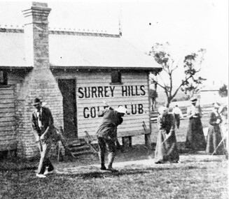
 Surrey Hills Historical Society Collection
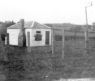
Photograph, The gate-keeper's shed, Surrey Hills Golf Club
Reproduced by permission of Mr John Arnold from his book: "The Riversdale Golf Club - a history, 1892-1977." Copyright to book: Riversdale Golf Club. Surrey Hills Golf Club operated from 1892-1908 then moved and became Riversdale Golf Club. The game was played across paddocks from Trafalgar Street, Mont Albert to Whitehorse Road and down Victoria Crescent to where Box Hill TAFE is now located in Elgar Road. There were problems with cows eating the tee flags! The clubhouse still exists as 30 Trafalgar Street.Apart from it association with the Surrey Hills Golf Club which is long gone, this image documents the landscape of pre-urban Surrey Hills.Black and white photo of a rectangular timber building with a slate hip roof and brick chimney on the LHS. The one visible window appears to be boarded up and has a door to its right. The building is fenced by posts and wire. A (?) street sign bearing the letters FLINT is at the right of the picture."The gate-keeper's shed was used as a clubhouse from 1895-1900."sports grounds, surrey hills golf club, riversdale golf club, timber building, john arnold -
 Surrey Hills Historical Society Collection
Photograph, Surrey Hills Golf Club clubhouse and players
Reproduced by permission of Mr John Arnold from his book: "The Riversdale Golf Club - a history, 1892-1977." Copyright to book: Riversdale Golf Club. Surrey Hills Golf Club operated from 1892-1908 then moved and became Riversdale Golf Club. The game was played across paddocks from Trafalgar Street, Mont Albert to Whitehorse Road and down Victoria Crescent to where Box Hill TAFE is now located in Elgar Road. There were problems with cows eating the tee flags! The clubhouse still exists as 30 Trafalgar Street. The Surrey Hills Golf Club was founded by Mr Hugh W McLeod in 1894. The first president was Mr A W Harston. Mr William Meader was the first honorary secretary and the club champion for several years. Another notable identity was Mr. Harry Culliton, who contributed golf notes to "The Argus" for many years.The image is significant in documenting the Surrey Hills Golf Club which is no longer in existence.Black and white photo of a timber building with an ornamental roof ridge and brick chimney. Two men in 'plus fours' and hats and three women in long dresses and hats have golf clubs in their hands. The men and one lady are practising swings. There is a mature tree in the background with a house to the right."A group of Surrey Hills players practising in front of the clubhouse early this century. The player in the background is heading towards the first tee. The house to his right can still be seen at 3 Beatty St., Mont Albert."sports grounds, surrey hills golf club, riversdale golf club, timber building, clothing and dress, john arnold -
 Surrey Hills Historical Society Collection
Photograph, Baby Health Centre in the Surrey Gardens, 1982
The Baby Health Centre opened in the Surrey Gardens in 1930 on the site previously occupied by the screen for outdoor pictures. Previously during the 1920s it had operated in the room underneath the rotunda in the Surrey Gardens. The room was also shared by other groups including the Surrey Hills Progress Association (SHPA). The SHPA raised 200 pounds to provide the materials for the building, which was built by voluntary labour under the leadership of Ralph Hayes, a local builder. The foundation stone was laid by Mrs A Latham, Mayoress of Camberwell on 31 March 1930. There is a bottle containing the names of the committee members sealed in the pillar behind the memorial stone. The centre was managed by a committee until 1975. Maternal health nurses associated with the centre included Sister D Thompson, Sister Newnham, Sister Kelsell, Sister Barker, Sister Sharp and Sister Bolton. Ref: Mrs D Lancashire - a long-serving member of the committee. The site of the Surrey Hills Maternal and Child Health Centre was moved to 18 Verdun Street, adjacent to the pre-school, in accord with Council policy to co-locate services and from a concern regarding solo staff working in relatively isolated locations. The building was included in the heritage overlay protecting the gardens and was refurbished by Council for community use. The cairn commemorates the work of Cr Albert Ernest Vine who was a Camberwell Councillor from 1926-1934 and 1937-1944; he was also Mayor on 1940-41. There is a photo of him in Mayoral robes in the City of Boroondara Library Service collection.Black and white photo of a timber building with a tiled roof and a brick veranda supported by brick and concrete pillars. In front of the baby health centre is a small cairn.surrey gardens, baby health centres, monuments and memorials, surrey hills progress association, cr albert ernest vine, sister d thompson, sister d. newnham, sister kelsell, sister barker, sister sharp and sister bolton, mrs a latham, ralph hayes, mrs d lancashire -
 Surrey Hills Historical Society Collection
Photograph, Grovedale Road Quarry in the 1920s - looking north, c1920
The quarry was part of John Butler Maling's property. He was one of the original settlers of the area and farmed the area between Weybridge Street and Whitehorse Road. Clay was quarried from part of this area and used to make the bricks used in the construction of his home, known as 'Ancyra'. This is still extant at the corner of Weybridge and James Streets. Maling grazed cows and used the quarry as a water source. He was the uncle of John Butler Maling, Mayor of Camberwell. He was married to Kate Conlon in 1882. They had 3 children: Silas Young, Alick and Zillah. Maling was born in c1829 in Shepreth, Cambridgeshire; he died in Surrey Hills on 9 October 1912 and is buried in Box Hill Cemetery - CE-*-0586. Mrs Kate Maling (born c1859 in Co Meath, Ireland) died at the property on 8 March 1921. She is buried in Brighton General Cemetery. Probate was valued at over 10,000 pounds and included other properties in Sandringham, Hawthorn and Macedon. At the time of her death the Surrey Hills property was described as being 23 cres with 2 brick houses, 1 cow, 2 heifers and 40 fowls or chickens. The property was subdivided after her death. The quarry was filled in after several drownings or near drownings and the land is now occupied by a park and playground maintained by the City of Boroondara. Beckett Park is sited on horizon to the left beyond the trees. This documents the landscape prior to close settlement and is material to early building and farming in the Surrey Hills area.Black and white photo of the quarry between Grovedale Road and James Street taken in the 1920s and looking north. In the foreground is an area of water with high banks dividing the horizontal centre. Beyond are paddocks and trees behind which is a row of at least 3 single-storey houses. Light poles can be seen along a distant street. There are many mature trees in the background. The houses and trees are positioned along Whitehorse Road in the vicinity of Westminster Street. Shadows indicate the photo was taken in early morning or evening.quarries, grovedale road, james street, surrey hills, balwyn, clay quarries, ancyra, kate conlon, kate maling, john butler maling, farming -
 Surrey Hills Historical Society Collection
Photograph, Home and surgery of Dr William Langley Carrington, 174 Union Road, 1935
The building was erected in c 1913 as a home / surgery for Dr James L Blakie (1868-1937), who originally lived / practised across the road. It was designed by architect Arthur William Plaisted (1890-1965) and is an early example of attic-style Californian bungalow style. Dr Carrington ( 1900-1970) succeeded Dr Blakie and practised at 174 Union Road from 1930-1970. Now known as the Surrey Hills Medical Centre.Black and white photo of the surgery and home of Dr and Mrs William Langley Carrington at 174 Union Road on the corner of Guildford Road, Surrey Hills.. The exterior of the building is decorated with paper lanterns around the windows and veranda for the Empire Day celebrations in 1935. The building is 2 storey, of brick construction with a tiled roof and front porch. It has a bay window front right. Shadows indicate the photo was taken early morning in winter.medical services, guildford road, union road, dr william langley carrington, mr arthur plaisted, dr james landells blakie, californian bungalow, dr bill carrington -
 Surrey Hills Historical Society Collection
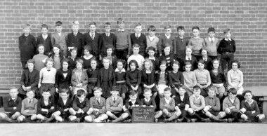
Photograph, Surrey Hills Primary School class photo, Grade 5, 1935
... of Grade 5 in 1935 taken outside the school building against... building against a brick wall. There are 54 students, 25 girls ...Black and white photo of Surrey Hills Primary School pupils of Grade 5 in 1935 taken outside the school building against a brick wall. There are 54 students, 25 girls and 29 boys. None are identified.On the rear in pen: Top LH corner - "SH History Nook / From McCracken family" + centre - "grade 5 1935".surrey hills primary school, schools, education, primary education, children, mccracken family -
 Surrey Hills Historical Society Collection
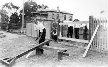
Photograph, St George's Church of England, Mont Albert working bee, early 1923 (2), 1923
The foundation stone for St George's Church of England, Mont Albert was laid in 1886 on land donated by Edward Dyer and the first service was preached in January 1887. From 1904 until 1907 it was known as Holy Trinity, Surrey Hills. The original church was weatherboard and replaced by a brick one in the Gothic Revival style which was designed by local architect George J V Blackburne, who also designed the Wesleyan School at Surrey Hills. The building was partly funded by donations, profits from a bazaar and concert, and other people donated furnishings. The church had boundaries along Mont Albert Road and St Georges Road. In 1998 the Church was sold and converted into a complex of units. Its current address is 19 St Georges Avenue, Mont Albert. The purpose of this working bee in 1923 was to close up the double gateway, which in earlier times had been used for entry of by horse-drawn vehicles to the church grounds. 'Lugano' was built in 1893 for William Wilson, a prominent stonemason and importer of marble fireplaces. In 1903 it became the home of William Holmes who was Chief Electrical Engineer for the Victorian Railways. He designed the electrification of the Melbourne suburban network. 'Lugano' stayed in the Holmes family until the 1930s. Norman Carter took many photos of Surrey Hills and Mont Albert from the 1920s in particular of events and activities associated with the Church of England.Black and white photo of 6 men behind and in front of a picket fence, a section of which has posts and railings only. In front of the fence is a wide grassy verge on which a bench is set up for cutting lengths of wood. A large Victorian house ('Lugano') can be seen in the background and a lamp post with a street sign. Beyond the house are mature eucalyptus trees.churches, holy trinity church, anglican church, st george's anglican church, working bees, lugano, william holmes, william wilson, norman brodley carter -
 Surrey Hills Historical Society Collection
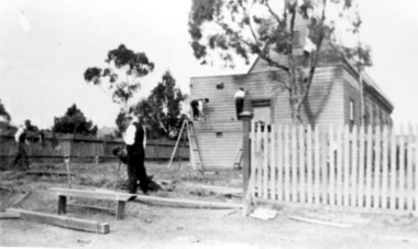
Photograph, St George's Church of England, Mont Albert working bee, early 1923 (1), 1923
The foundation stone for St George's Church of England, Mont Albert was laid in 1886 on land donated by Edward Dyer and the first service was preached in January 1887. From 1904 until 1907 it was known as Holy Trinity, Surrey Hills. The original church was weatherboard and replaced by a brick one in the Gothic Revival style which was designed by local architect George J V Blackburne, who also designed the Wesleyan School at Surrey Hills. The building was partly funded by donations, profits from a bazaar and concert, and other people donated furnishings. The church had boundaries along Mont Albert Road and St Georges Road. In 1998 the Church was sold and converted into a complex of units. Its current address is 19 St Georges Avenue, Mont Albert. Norman Carter took many photos of Surrey Hills and Mont Albert from the 1920s, in particular of events and activities associated with the Church of England.Black and white photo of 4 men at a working bee in the grounds of St George's Anglican Church in Mont Albert. Two men are on a scaffold working on the weatherboards of the church; the other two are working on fencing. One boundary is marked with a paling fence; the other has a section of picket fencing and a large open section with no fencing. There is a mature eucalyptus tree in front of the church; others are beyond the paling boundary fence. The church itself is a simply constructed weatherboard building.churches, holy trinity church, anglican church, st george's anglican church, working bees, norman brodley carter -
 Surrey Hills Historical Society Collection
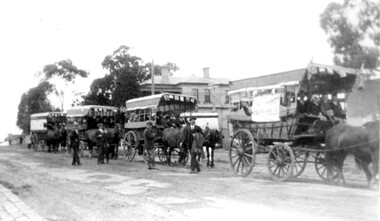
Photograph, Preparing to leave for the St George's Church of England Sunday School picnic, Mont Albert Road, 1922
The drags would have been leaving St George's Church of England in Mont Albert Road. The foundation stone for St George's Church of England, Mont Albert was laid in 1886 on land donated by Edward Dyer and the first service was preached in January 1887. From 1904 until 1907 it was known as Holy Trinity, Surrey Hills. The original church was weatherboard and replaced by a brick one in the Gothic Revival style which was designed by local architect George J V Blackburne, who also designed the Wesleyan School at Surrey Hills. The building was partly funded by donations, profits from a bazaar and concert, and other people donated furnishings. The church had boundaries along Mont Albert Road and St Georges Road. In 1998 the Church was sold and converted into a complex of units. Its current address is 19 St Georges Avenue, Mont Albert. The annual Sunday School picnic was held at Hampton and drags were the usual mode of transport. 'Lugano' was built in 1893 for William Wilson, a prominent stonemason and importer of marble fireplaces. In 1903 it became the home of William Holmes who was Chief Electrical Engineer for the Victorian Railways. He designed the electrification of the Melbourne suburban network. 'Lugano' stayed in the Holmes family until the 1930s. The annual Sunday School picnic was held at at a variety of locations and drags were the usual mode of transport. Donor information is that this was taken as the congregation prepared to depart for at Hampton on the picnic held on 25/2/1922. There are 2 copies: the original donated print and an enlargement. The original was mounted on card with photo mounts along with 506, 871, 872, and 873. It measures 13 cm x 9 cm.Black and white photo of 4 'drags' (horse-drawn hooded carriages) lined up in Mont Albert Road near the corner of St George's Avenue, in readiness for departure for the Sunday School picnic. The carriages are loaded with people and decorated with flags. The front carriage has a material sign attached to the side; the top line of writing is not decipherable, but the bottom one reads "SURREY HILLS". Four men stand in the road, which has bluestone curb and channelling. In the background is 'Lugano'.On rear in ink: "S.S. picnic to Hampton / 25th. Feb. 1922" and in a different hand in biro: "At Mont Albert. St George's Church"churches, holy trinity church, anglican church, sunday schools, picnics, lugano, horse-drawn vehicles, william wilson, willaim holmes, st george's church of england, mont albert, mont albert road -
 Surrey Hills Historical Society Collection
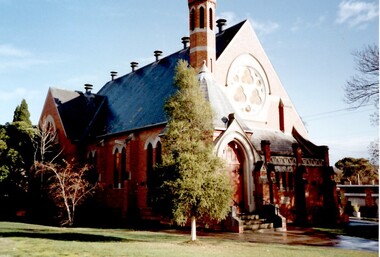
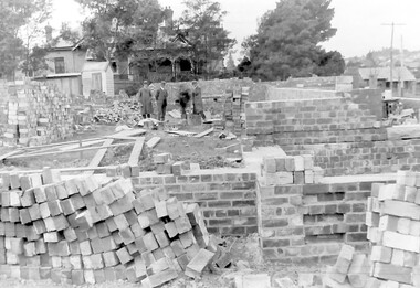
Photograph, Holy Trinity Church of England, Surrey Hills during construction, 1922
St George's Church of England, Mont Albert was built in 1886 and from 1904 until 1907 was known as Holy Trinity, Surrey Hills. As the population increased there was a need for a church in Surrey Hills. This brick church was consecrated in 1922 and replaced the earlier one built in 1907 on the adjacent site in Union Road. The house behind the church at 1 Montrose Street belonged to Mr W B Vine. There are 2 copies: the original donated print and an enlargement. The original is mounted on card with photo mounts along with 884, 885, 886 and 512. It measures 13 cm x 9 cm. Norman Carter took many photos of Surrey Hills and Mont Albert in the 1920s; many were associated with events and activities of the Church of England.Black and white photo of 3 men inspecting the construction site of the Holy Trinity Church of England in Union Road, Surrey Hills. The foundations are surrounded by piles of bricks. In the background is a small timber shed and beyond that a timber Edwardian home partly hidden by foliage.churches, holy trinity church, anglican church, building construction, montrose street, w b vine -
 Surrey Hills Historical Society Collection
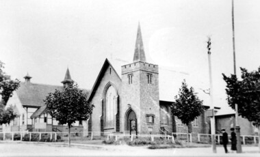
Photograph, Holy Trinity Church of England, Surrey Hills post 1926, After 1926
St George's Church of England, Mont Albert was built in 1886 and from 1904 until 1907 was known as Holy Trinity, Surrey Hills. As the population increased there was a need for a church in Surrey Hills. This brick church was consecrated in 1922 and replaced the earlier one built in 1907 on the adjacent site in Union Road. After construction of the brick church, the earlier one became a Sunday School. The copper spire was added in 1926, which dates this photo as post-1926. Norman Carter took many photos of Surrey Hills and Mont Albert in the 1920s; many were associated with events and activities of the Church of England.Black and white photo of the 'newly' constructed brick Holy Trinity Church in Union Road, Surrey Hills taken from near the south-west corner of Guildford Road. Further up the hill is the earlier church. Both buildings are bounded by a simple post and rail fence. Immature street trees are planted on both sides of Union Road.churches, holy trinity church, anglican church, sunday schools, norman carter