Showing 622 items
matching local -- sources. | australia -- historiography.
-
 Eltham District Historical Society Inc
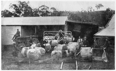
Photograph, Allwood Nurseries, Diamond Creek, Vic
Allwood Nurseries in Hurstbridge was operated by W.G (William George) Gray. By 1922 he operated a well cultivated property of 64 cleared acres, 56 of which were under nursery healthy stock, principally apples, peaches, plums and cherries. In addition to 4 acres of potatoes. He grew seedling stock which he supplied to other local orchardists and the overseas market. This photo forms part of a collection of photographs gathered by the Shire of Eltham for their centenary project book, "Pioneers and Painters: 100 years of the Shire of Eltham" by Alan Marshall (1971). The collection of over 500 images is held in partnership between Eltham District Historical Society and Yarra Plenty Regional Library (Eltham Library) and is now formally known as 'The Shire of Eltham Pioneers Photograph Collection.' It is significant in being the first community sourced collection representing the places and people of the Shire's first one hundred years.Digital imagesepp, shire of eltham pioneers photograph collection, hurstbridge, allwood nurseries, export, nursery -
 Glen Eira Historical Society
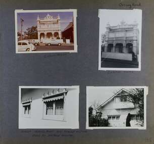
Album - Album page, Orrong Road, Circa 1972
This photograph is part of the Caulfield Historical Album 1972. This album was created in approximately 1972 as part of a project by the Caulfield Historical Society to assist in identifying buildings worthy of preservation. The album is related to a Survey the Caulfield Historical Society developed in collaboration with the National Trust of Australia (Victoria) and Caulfield City Council to identify historic buildings within the City of Caulfield that warranted the protection of a National Trust Classification. Principal photographer thought to be Trevor Hart, member of Caulfield Historical Society. Most photographs were taken between 1966-1972 with a small number of photographs being older and from unknown sources. All photographs are black and white except where stated, with 386 photographs over 198 pages.Victorian Heritage Database https://vhd.heritagecouncil.vic.gov.au/places/35576 No. 70 Orrong Road is important as an exceptionally ornate Boom style villa residence in the terraced form and in this respect is rare in Caulfield. Its architectural value is enhanced by its intact state and by the manner in which its bold architectural expression is carried through into the hallway and staircase. Victorian Heritage Database - National Trust local significance 284 Orrong Road Caulfield https://vhd.heritagecouncil.vic.gov.au/places/65700 A house designed by Harold Desbrowe Annear in 1917 and believed to have been the first "all electric" house in Melbourne. It has been extensively altered.Page 164 - four photographs of 2 different houses on Orrong Road. The top left photo is in colour while the others are in black and white.Handwritten: Orrong Road [top right] / Lisborn House [ (ed. correct name is LISBON HOUSE), under top left photo] / Lisborn House [under top right photo] / [under bottom right photo] / CORNER ORRONG ROAD AND PEARSON AVENUE / HOUSE BY DESBROWE ANNEAR [under bottom left photo] / 164 [bottom right]trevor hart, orrong road, lisbon house, lisborn house, elsternwick, pearson grove, st kilda east, caulfield north, terrace houses, cast iron work, verandahs, balconies, parapets, arches, cars, streetscapes, attic houses, desbrowe annear -
 Glen Eira Historical Society
Album - Album page, Paynswicke, Gladstone Pde & Hartington St, Circa 1972
This photograph is part of the Caulfield Historical Album 1972. This album was created in approximately 1972 as part of a project by the Caulfield Historical Society to assist in identifying buildings worthy of preservation. The album is related to a Survey the Caulfield Historical Society developed in collaboration with the National Trust of Australia (Victoria) and Caulfield City Council to identify historic buildings within the City of Caulfield that warranted the protection of a National Trust Classification. Principal photographer thought to be Trevor Hart, member of Caulfield Historical Society. Most photographs were taken between 1966-1972 with a small number of photographs being older and from unknown sources. All photographs are black and white except where stated, with 386 photographs over 198 pages. House is commonly spelt as "Payneswicke".From: Glen Eira Heritage Management Plan (1996) by Andrew Ward and Associates "Payneswicke" is locally significant as a prominent and substantially intact villa of its period, distinguished by its cast cement enrichment, unpainted stuccoed surfaces and commanding aspect to the south-west. Its role for a period as home for local builder, Patrick Millane (compare no. 11 Gladstone Parade) is of interest. In 1889, a nine roomed brick house was in the course of erection on the site. The house was completed in 1890 and Millane took up residence. Millane continued as owner/ occupant in 1894. However, in 1899, although Millane still occupied the house, ownership had been taken over by the Land Mortgage Bank. By 1910, Andrew Brown was occupant. Occupancy passed to Edward Brown by 1920 and to Miss A.N. Brown by 1930. Miss Brown continued to live there in 1941.Page 50 of Photograph Album with three exterior photographs (2 landscape and 1 portrait) of Paynswicke, a double storey house.Hand written: No 13 [top right] / "Paynswicke" N.E. cnr Gladstone Pd & Hartington St [top right] / 8 Oct 1966 [under top left photo] / 50 [bottom right] trevor hart, 1880's, 1890's, payneswicke, patrick millane, gladstone parade, unpainted stuccoed surfaces, cast cement enrichment, hartington street, villa residence, italianate, elsternwick, victorian, mansion, cast iron verandahs, return verandahs, curved windows, full length windows, land mortgage bank, andrew brown, edward brown, a n brown, paynswicke -
 Glen Eira Historical Society
Album - Album page, Glen Huntly Road, Circa 1972
This photograph is part of the Caulfield Historical Album 1972. This album was created in approximately 1972 as part of a project by the Caulfield Historical Society to assist in identifying buildings worthy of preservation. The album is related to a Survey the Caulfield Historical Society developed in collaboration with the National Trust of Australia (Victoria) and Caulfield City Council to identify historic buildings within the City of Caulfield that warranted the protection of a National Trust Classification. Principal photographer thought to be Trevor Hart, member of Caulfield Historical Society. Most photographs were taken between 1966-1972 with a small number of photographs being older and from unknown sources. All photographs are black and white except where stated, with 386 photographs over 198 pages. From: Glen Eira Heritage Management Plan (1996) by Andrew Ward and Associates Moore's Buildings", were built in 1891 and comprising 5 shops. In 1888, Hugh Moore, a gentleman, subdivided his land in Glen Huntly Road, north side between Selwyn Street and St Georges Road into 27 lots, with a right of way separating them from his property "Glenmoore". The subdivision was known as the "Glenmoore Estate". Purchases of land included local builders Corkill, French and Pugh. Moore retained five lots and W.W. Jamieson bought lots 11 to 14. "Moore' s Buildings are locally important for their association with the early Elsternwick land owner, Hugh Moore, whose home, "Glenmoore", at 1 St.Georges Road (qv) survives. They recall Elsternwick's role in the Land Boom and survive as a most prominent row in the Glen Huntly Road shops, enhanced by the survival of the unpainted stuccoed surfaces to nos. 307-311. 287-289 Glen Huntly Road: contributory to HO72, Elsternwick Estate and Environs, City of Glen Eira.Page 63 of Photograph Album with one landscape photograph of retail shops (Moore's Buildings).Hand written: 287-289 Glen Huntly Road [under photo] / 63 [bottom left] trevor hart, shop, grocer, stuccoed, terrace, victorian terrace, protruding parapet, ornate render, hugh moore, 1890's, moore's buildings, glenmoore, glenmoore estate, shopping centres, milk bars, cars, victorian style, glen huntly road, glenhuntly road, elsternwick -
 Flagstaff Hill Maritime Museum and Village
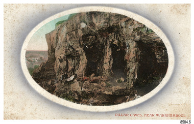
Postcard - Scenic, Warrnambool, Pillar Caves, near Warrnambool, 1902-1929
The nine postcards in this set were donated together and date to the early 1900s. All but one postcard in this set shows images of Warrnambool, in the Western District of Victoria; the other has a London image. The postcards were all printed in Great Britain according to that country’s postal regulations. The fronts of all cards have titles printed in red. Most of the images on the cards are attributed to photographer Joseph Jordan and belong to the Jordan Series. The back of these cards has an outline for a postage stamp, a vertical dividing line and a heading on each side of the line to separate the Correspondence from the Address. Postcards or ‘correspondence cards’ appeared in Britain in 1894. They were plain cards with a space for the message on one side and an address on the other; regulations didn’t allow anything but the address to be written on the ‘address’ side. In 1902 the British regulations then allowed a picture to be printed on the front and the address on the back, so messages had to be written on the picture side. Soon, the regulations changed and the back was divided for a message and the address. Pliiar Caves, near Warrnambool – The formation at the front of the cave resembles the pillars of a porch, giving the cave its name. Local social media discussion locates the caves near Lake Gillear, east of Warrnambool. The area was popular with young lads as a place to explore and to go rabbiting. The caves in this area are home to colonies of bats and have been a source of bat feces or bat guano, which is an enriching additive to soil. The 19th century sailing ships in the Nitrogen or Guano trade collected large quantities of guano from caves and popular bird nesting locations to sell as a rich fertiliser, due to its high nitrogen and phosphorus properties. Joseph Jordan - Joseph Jordan was born in 1841 in Leicester England. When he was 16 he joined the 7th Queen's Own Hussars and was sent to India at the outbreak of the mutiny. He took part in the relief of Lucknow and remained in India for eleven years. It was during this time that he became interested in photography. He was posted to New Zealand and later came to Victoria, becoming a sergeant major of the Mounted Rifles. In the mid-1880s he came to the Western district where he was responsible for establishing units of the Mounted Rifles in various country towns such as Dunkeld, Mortlake, Panmure, Bushfield, Koroit etc. He resigned from the army in 1889 and set up a professional photography studio in Liebig Street, Warrnambool. He became very well known in the Western District for family photographs, official photographs of local councillors and groups as well as views of local scenery. In 1891 he photographed the wrecked barque ‘Fiji’ at ‘Wrecks Beach’ near Princetown. His business was taken over by his son Arthur around 1917. Joseph was a keen rifle shot and in 1924 he donated the "Jordan Shield" as a prize to the Victorian Rifle Association. He was made a "Life Honorary Member" of the Warrnambool Returned Soldiers League and in 1933 he was recognised as being the oldest living soldier in Victoria. Joseph died in 1935 aged 95.The image of the Pillar Caves rock formation with figures on it suggests that the location was a popular place to visit. The choice of subject for this postcard indicates the popularity of Warrnambool's natural environment as a tourist attraction at a time when ships called coastal traders brought passengers and cargo to the Port of Warrnambool from ports along Victoria's southwest coast. The presence of bats in local caves also connects the postcard to the 19th century Nitro Trade and Guano Trade, when bat guano was collected and sold for plant fertiliser around the world. Joseph Jordan is a significant figure in Warrnambool history as he helped to establish early units of the Mounted Rifles (G Company) in local towns during the late 1880's and later, photographed local scenes, groups and citizens of early Warrnambool.Postcard, one of nine, landscape orientation, coloured print within an oval border and mauve-toned shading. The cameo image shows figures on the high, grass-topped cliff, one between the likeness of pillars in the cave entry, and others walking on the rocks nearby. The background below is rough ground. There is no correspondence written on the card. The back has inscriptions and outlines for a postage stamp. Jordan Series, printed in Great Britain.Front, in red: “PILLAR CAVES, NEAR WARRNAMBOOL” Back in black: “Jordan Series” “POST CARD” “PRINTED IN GREAT BRITAIN” “For correspondence” “The Address only to be written here”flagstaff hill maritime museum, flagstaff hill maritime village, flagstaff hill maritime museum and village, maritime museum, warrnambool, great ocean road, warrnambool and district, warrnambool scenes, local scenes, views of warrnambool, joseph jordan, jordan series, jordan photography, postcard, souvenir, correspondence, cameo postcard, landscape, rock formation, pillar caves, pillars cave, lake gillear, rebbiting, bats, guano, nitro trade, fertilizers -
 Flagstaff Hill Maritime Museum and Village
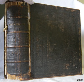
Book - Religious Book, Oxford University Press, The Holy Bible, 1866
This King James version of the Holy Bible, with Old and New Testaments, was published in 1866 in London. The large Bible contains family records of Joseph Bell (born 9-5-1829) and Elizabeth Bell (born 22-101833). Joseph and Elizabeth Bell were married on 12-09-1854 in St Paul's church, in Bristol, England. The loose endpaper within the Bible is headed 'Singleton, 2nd day of 1st month 1869" It records their marriage and the birth of their ten children. between 1856 and 1878. It appears that the entries up until their 8th child were written at the same time, 2nd January 1869, with the last two entries for children number 9 and 10, written at a later date. This fits with the Bible being published in 1866. The children were Thomas, Mary, James, John, Ruth, Andrew, Joseph, Elizabeth, Lewis and Hannah. Further research is being carried out to connect this branch of the Bell family with local history.The Holy Bible is significant for being published over 150 years ago when printed books were very expensive. The book contains handwritten records of the Bell family of Bristol and is a significant source of the Bell family history. Book, black hard cover with embossed pattern and gold test, metal locking clasp. King James Version of the Holy Bible, containing the Old and New Testaments. It was published by Oxford University Press in 1866. Inscriptions on the loose endpaper list the marriage of Joseph and Elizabeth Bell in 1854 at St Paul's, Bristol, England, and their ten children born from 1856 to 1878.Spine: "HOLY BIBLE" Fly: "THE HOLY BIBLE CONTAINING THE OLD AND NEW TESTAMENTS: TRANSLATED OUT OF THE ORIGINAL TONGUES:: AND WITH THE FORMER TRANSLATIONS DILIGENTLY COMPARED AND REVISED, BY HIS MAJESTY'S SPECIAL COMMAND" "APPOINTED TO BE READ IN CHURCHES" "OXFORD: PRINTED AT THE UNIVERSITY PRESS FOR THE BRITISH AND FOREIGN BIBLE SOCIETY, INSTITUTED IN LONDON IN THE YEAR 1804." "SOLD TO SUBSCRIBERS AT THE SOCIETY'S HOUSE, EARL STREET, BLACKFRIARS, LONDON." "MDCCCLXVI" (converts from Roman Numerals to the number 1866) LOGO with a motto: [shield with scroll, three crowns and test] "dominus illuminatio mea" (Latin, translates to "The Lord is My Light") On endpapers: Heading in script: "Singleton 2nd day of 1st month 1869" and listed below " Joseph Bell, born 9/5/1829 married Elizabeth Bell, born 22/10/1833 on 12/9/1854 at St Pauls, Bristol, England." (Numbered 1 to 10, their children and their birth dates, from 1856 to 1878, are also listed. The children were Thomas, Mary, James, John, Ruth, Andrew, Joseph, Elizabeth, Lewis and Hannah.) flagstaff hill, flagstaff hill maritime museum and village, warrnambool, maritime museum, maritime village, great ocean road, shipwreck coast, holy bible, book, religious book, bell family, bell family bible, elizabeth bell, joseph bell, 1826, 1833, 1854, st paul's bristol -
 Flagstaff Hill Maritime Museum and Village
Document - Framed Poster, Borough of Warrnambool, Victoria, Australia, after 30/06/1875
This document, also referred to as a word picture or Tablet, is framed in glass and timber with gilt trim, is handwritten with colour highlights. The penned letters rest on ruled guide lines, decorated where the lines intersect. The writing gives a description of the state of Borough of Warrnambool around 1875; its location, the area it covers, its population, Harbour and facilities, public buildings and institutions, imports and exports, financial worth, number of houses, connection with other areas of the Colony. A possible reason and origin for the document is found in an article ‘Link with US Exhibition’ from the Warrnambool Standard of December 19, 1981, written by local historian Bruce Morris. The writer mentions that the Warrnambool Borough Council met on 15th June 1875 and recorded a letter from G.C. Levey , secretary to the Melbourne group of commissioners representing the Colony, and Victoria in particular, for the Philadelphia Centennial Exhibition of 1876. The letter asks Council to provide “statistics as to the population, social condition and commercial and industrial state of the district in and around Warrnambool.” A sub committee was formed for the project. The Mayor, Cr. Thomas King, wrote and signed a Report, presented to the council on July 14, 1875, in which “The Committee … begs to recommend that a Tablet be prepared setting for the particulars respecting the following matters relating to the Borough”. The matters included area, population, annual income, churches, schools, other public buildings, societies and companies, general description of houses erected, and returns of exports and imports for 1874. The minutes note that the Report was adopted. The article above also notes the opinion of Warrnambool printers who have examined the document; it is almost certainly to be an old lithograph, which means there could be several copies. It is possible that there may be a copy in Melbourne and another in Philadelphia. It is interesting to note that (1) the quoted location co-ordinates are for an “Unnamed Road, Packsaddle NSW 2880, Australia”, and that the DMS co-ordinates for Warrnambool’s Council Offices differ, being 38.23.9.12 South, 142.28.52.887. (2) the date for “Exports and Imports for the Year Ending 30th June 1875” is different to the period mentioned by Cr. King in the sub committee’s Report of recommendation “returns of exports and imports for 1874”. The information required to have the figures for the end of June 1875 would need to have been compiled very quickly for the Tablet to be ready for the opening of the Philadelphia Exhibition on 10 May 1876. The document/certificate shows the following – - - - - - - - - - - - - - - -- - - - - - - - - - - - - - -- - - - - - - - - - - - - - -- - - - - - - - - - - - - - - “Victoria Australia, Borough of Warrnambool. Latitude, 30.24.50 South, Longitude 142.32 East The Principal Port in the Western District of the Colony and the Centre of its Choicest Agricultural Lands. Established a Municipality in 1855, and Created a Borough 1863. Population in 1875 4,500. Warrnambool is the nearest Port to Melbourne on the Western Seaboard, being about 160 miles distant. Coaches run to and from the Metropolis daily, in connexion [connection] with the Railway of Geelong and Steamers belonging to Local Companies sail between Melbourne, Warrnambool, Belfast [renamed Port Fairy], and Portland several times weekly. The Harbour is known as Lady Bay, and is partially protected by a reef of rocks stretching from the mouth of the Hopkins River. The formation of a Breakwater has been decided upon by the Government, to extend 600 yards, at an estimated cost of £100,000. There are two substantial Jetties, one of 800 and the other of 600 feet in length. The former is connected with the Town by means of a Tramroad, along which Goods, inwards & outwards, are conveyed, & the latter has been constructed solely for the purpose of facilitating the transit of material for the formation of the Breakwater. In addition to the trade of the Borough and District, the principal Townships up country receive their supplies from Melbourne and ship their exports through Warrnambool. Potatoes form the staple produce of the district, and the richness of the soil can be estimated by the fact that the Government Statistics for 1875 give as the average yield a return of Seven Tons to the acre. Several thousand acres between Warrnambool and Tower Hill are now being laid down in Potatoes by Tenants who have leased the lands at rates up to £5 per acre for the season 1875-6. Wool, Tallow, hides &c are also largely exported, while the shipments of all descriptions of Farm Produce are annually increasing. Area of Borough, 3362 Acres. Net Annual Value £27,000. Annual Revenue £5,500. Number of Houses in Borough 800. Public Buildings and Institutions Churches. Church of England, Roman Catholic, Presbyterian, Wesleyan, Congregational and Baptist. Schools. Three State Schools, average attendance nearly 1000. New Building in course of erection. Several private establishments. Banks. Bank of Australasia, Bank of Victoria, National Bank, Colonial Bank and Savings Bank. Public Buildings. Court house, Custom house, Post & Telegraph Offices, Survey & Land Offices, Shire £, Town Hall, Mechanics Institute, Volunteer Orderly Room, Odd Fellows Hall, Hospital & Benevolent Asylum, Temperance Hall &c. Companies & Societies. Steam Navigation Co, Woolen Mill Co, Gas Co, Racing Club, Amateur Turf Club, Agricultural Society, Farmers’ Club, Cricket Club, Anglers’ Society, Building Society, Freemasons Odd Fellows, Foresters, Druids, Hibernians. Protestant Alliance, Rechabites, Sons of Temperance, &c, Fire Brigade &c. --- Exports and Imports for the Year Ending 30th June 1875 –-- --Exports Total Tonnage 27,800 (Calculated at the Current Warrnambool Market Prices) Potatoes Wool Wheat Barley Hides Skins Fowls Butter Cheese Eggs Tallow Leather Ale Pigs Sheep Sundries --Imports 13,000 Tons Of the Estimated Value of £520,000 Total Tonnage of Exports and Imports 40m900 Tons, Value £806,627 Passenger Travels, to ad from Warrnambool during year, 10,000 persons Revenue from all sources paid through Warrnambool Sub Treasury From 1860 to June 1875 £1, 292, 300 Thomas King [signed] Mayor Henry T Read [signed] Town Clerk” - - - - - - - - - - - - - - -- - - - - - - - - - - - - - -- - - - - - - - - - - - - - -- - - - - - - - - - - - - - - The document is of historical, social, economic and local significance in that it summarises activities, business, community, trade, travel and government at a point in time in Warrnambool’s history – 30th June 1875.Document, also referred to as a ‘word picture’ or ‘tablet’. Document is framed in glass and timber with gilt trim, handwritten with colour highlights. The penned letters rest on ruled guide lines, decorated where the lines intersect. Document outlines the establishment of Warrnambool as a Municipality in 1855 and Borough in 1863, with a population of 4,500 in 1875. It states geographic location, public buildings and institutions, harbor facilities and imports and exports for the year ending 30th June 1875. Two signatures "Thomas King" Mayor and "Henry T Read" Town Clerk. It shows the Coat of Arms of the Borough of Warrnambool.Signatures - "Thomas King" Mayor and "Henry T Read" Town Clerk. Warrnambool Coat of Arms; “British Coat of Arms, above sailing vessel and sheaf of wheat in sun, motto “By these we flourish” and around circumference “Borough of Warrnambool 1855”flagstaff hill, warrnambool, shipwrecked coast, flagstaff hill maritime museum, maritime museum, shipwreck coast, flagstaff hill maritime village, great ocean road, borough of warrnambool, municipality of warrnambool, document borough of warrnambool 1875, word picture of warrnambool 1875, tablet of borough of warrnambool 1875, statistics borough of warrnambool 1875, lithograph borough of warrnambool 1875, coat of arms warrnambool, warrnambool city motto – in these we flourish, establishment of warrnambool, warrnambool history, thomas king mayor of warrnambool, henry t read town clerk of warrnambool, warrnambool breakwater, warrnambool jetty, warrnambool imports and exports 1875, warrnambool agriculture 1875, warrnambool business 1875, warrnambool population 1875, centennial exhibition philadelphia 1876, framed certificate -
 City of Moorabbin Historical Society (Operating the Box Cottage Museum)
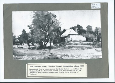
Photograph, B/W Watercolour,'Spring Grove' Charman Cottage built c1855 E Barlow c 1900, Elsie Barlow, c1900
... . 'The Spring' was an important water source for the local Aboriginal...' was an important water source for the local Aboriginal people ...This is a B/W photograph of a Water colour by Elsie Barlow c 1900. The original water-colour is in the collection of the Beaumaris and District Historical Trust in the State Library of Victoria. 'Spring Grove' was the home of the Charman family in the Parish of Moorabbin. Stephen Charman, aged 21years, arrived in Melbourne in 1842 as one of Henry Dendy's Emigrants. 1852 he purchased 160 acres for £328 bounded by Charman Rd and Balcome Rd. 'The Spring' was an important water source for the local Aboriginal people and then for the early settlers. Charman's first wife Harriet and their infant child died and in 1850 he married a widow with 5 children, Mary Gettens. Their first home was made of wattle and daub and they had 7 more children. Later a weatherboard cottage was built c 1855 Together they developed a market garden and specialized in marigolds which were sold for medicinal purposes to the Melbourne Chemists - Martin & Pleasance . The first Methodist Church Services were held at Spring Grove and the Charmans donated land in 1857 for the first Chapel, Cemetery and Primary School . Mary died 1870 and Stephen married again and moved to Gippsland where he died aged 85 in 1906Stephen and Mary Charman were pioneer market gardeners in Moorabbin Shire 1842 and were involved in the development of Church, school and community in the area now called Cheltenham. Charman Road Cheltenham was a boundary of their land. Black & White photograph of a Watercolour of Charman family cottage built 1885 Cheltenham Signed E Barlow on back ; A Cottage in Charman Road - the Dandelion Season / by Elsie Barlow / In the Collection of the State Library Victoria / Reproduction requires the permission of the Library Moorabbin Standard Newspaper moorabbin, cheltenham, dendy henry, dendy's special survey 1841, assisted emigrants early settlers, pioneers, market gardeners, marigold flowers, pharmacy, charman stephen, gettens mary, charman harriet, methodist church, primitive methodists, box william, box elizabeth, state schools, education, moorabbin shire, moorabbin roads board, city of moorabbin, kingston city council -
 City of Moorabbin Historical Society (Operating the Box Cottage Museum)
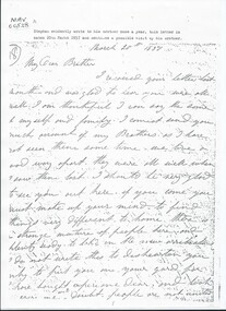
Document, Photocopy Letter Stephen Charman to Michael Charman UK 1857, 1857
... ' was an important water source for the local Aboriginal people...' was an important water source for the local Aboriginal people ...Stephen Charman, aged 21years, arrived in Melbourne in 1842 as one of Henry Dendy's Emigrants. 1852 he purchased 160 acres for £328 bounded by Charman Rd and Balcome Rd. 'The Spring' was an important water source for the local Aboriginal people and then for the early settlers. Charman's first wife Harriet and their infant child died and in 1850 he married a widow with 5 children, Mary Gettens. Their first home was made of wattle and daub and they had 7 more children. Later a weatherboard cottage was built c 1855 Together they developed a market garden and specialized in marigolds which were sold for medicinal purposes to the Melbourne Chemists - Martin & Pleasance . The first Methodist Church Services were held at Spring Grove and the Charmans donated land in 1857 for the first Chapel, Cemetery and Primary School . Mary died 1870 and Stephen married again and moved to Gippsland where he died aged 85 in 1906 Stephen and Mary Charman were pioneer market gardeners in Moorabbin Shire 1842 and were involved in the development of Church, school and community in the area now called Cheltenham. Charman Road Cheltenham was a boundary of their land. Letter, handwritten from Stephen Charman to his brother Michael in UK 1857 x 3 pageshandwrittenmoorabbin, cheltenham, dendy henry, dendy's special survey 1841, assisted emigrants, early settlers, pioneers, market gardeners, marigold flowers, pharmacy, charman stephen, gettens mary, charman harriet, methodist church, primitive methodists, box william, box elizabeth, state schools, education, moorabbin shire, moorabbin roads board, city of moorabbin, kingston city council, charman michael, cancel -
 City of Moorabbin Historical Society (Operating the Box Cottage Museum)
Document, Photocopy Letter Thomas Charman to Michael Charman UK 1878, 1878
... source for the local Aboriginal people and then for the early... and Balcome Rd. 'The Spring' was an important water source ...Thomas Charman came to Australia with his brother Stephen and went to Sydney. Thomas came to Melbourne c 1853 with a large dray and bullock team and with his son took supplies to the Victorian Gold digging sites. Quite profitably. Stephen Charman, aged 21years, arrived in Melbourne in 1842 as one of Henry Dendy's Emigrants. 1852 he purchased 160 acres for £328 bounded by Charman Rd and Balcome Rd. 'The Spring' was an important water source for the local Aboriginal people and then for the early settlers. Charman's first wife Harriet and their infant child died and in 1850 he married a widow with 5 children, Mary Gettens. Their first home was made of wattle and daub and they had 7 more children. Later a weatherboard cottage was built c 1855 Together they developed a market garden and specialized in marigolds which were sold for medicinal purposes to the Melbourne Chemists - Martin & Pleasance Thomas Charman arrived in Australia 1842 with his brother Stephen and moved to Sydney where he obtained a large dray and bullock team. He delivered supplies to the Goldfields and realized this was more secure than chancing to find gold by digging. Thomas returned to Melbourne when the Victorian Mines became more numerous than NSW and profitably delivered to the Victorian gold fields .Letter, handwritten from Thomas Charman to his brother Michael in UK 1878 x 3 pagesHandwritten -
 City of Moorabbin Historical Society (Operating the Box Cottage Museum)
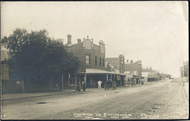
Photographs , Postcards x4 Charman Rd Cheltenham c 1910, c1910
... ' was an important water source for the local Aboriginal people... source for the local Aboriginal people and then for the early ...After the arrival of the Cheltenham Railyway Station Charman Road became the main shopping centre. From 1 small shop - Mrs Meeres who sold sweets, school requisites and drapery - it proceeded to develop throughout the 1890's with various traders until the 1910 Postcards show many shops on both sides of the road, Stephen Charman, aged 21years, arrived in Melbourne in 1842 as one of Henry Dendy's Emigrants. 1852 he purchased 160 acres for £328 bounded by Charman Rd and Balcome Rd. 'The Spring' was an important water source for the local Aboriginal people and then for the early settlers. Charman's first wife Harriet and their infant child died and in 1850 he married a widow with 5 children, Mary Gettens. Their first home was made of wattle and daub and they had 7 more children. Later a weatherboard cottage was built c 1855 Together they developed a market garden and specialized in marigolds which were sold for medicinal purposes to the Melbourne Chemists - Martin & Pleasance . The first Methodist Church Services were held at Spring Grove and the Charmans donated land in 1857 for the first Chapel, Cemetery and Primary School . Mary died 1870 and Stephen married again and moved to Gippsland where he died aged 85 in 1906 Stephen and Mary Charman were pioneer market gardeners in Moorabbin Shire 1842 and were involved in the development of Church, school and community in the area now called Cheltenham. Charman Road Cheltenham was a boundary of their land.4x Black & White Postcards c 1910 of Charman Road Cheltenham VictoriaFront; CHARMAN RD. CHELTENHAM P. FAIRLAM PHOTOfairlam p, cheltenham railway station, moorabbin, cheltenham, dendy henry, dendy's special survey 1841, assisted emigrants early settlers, pioneers, market gardeners, marigold flowers, pharmacy, charman stephen, gettens mary, charman harriet, methodist church, primitive methodists, box william, box elizabeth, state schools, education, moorabbin shire, moorabbin roads board, city of moorabbin, kingston city council, cancel, cheltenham primary school -
 City of Moorabbin Historical Society (Operating the Box Cottage Museum)
Photograph, Black & White, Methodist Children's Home Cheltenham Boys & Briquettes 1935, 1935
Boys from the Methodist Children's Home Cheltenham collecting Briquettes from the shed. Briquettes, made from Brown coal, were an economical source of heating for the Home The Methodist Children's Home in Cheltenham was founded c1880 to provide housing for neglected children from the inner city. The Founders aimed to provide regular nourishment, a stable environment and integrate the children into the local community thereby improving their education and lives. ( see 00561) 1950's saw a new direction for the support of children and families in poor and difficult situations . The new Burwood Homes Facility opened in 1951 and children were transferred from Cheltenham in 1952. The land was sold to the St John of God, Catholic Order in1953 who maintained an orphanage until Myer Pty Ltd bought the site in 1967 and constructed the Southland Shopping Centrec1892-1953 The Methodist Children's Home Cheltenham was founded to provide safe accommodation and education for neglected children from the inner city slums. Black & White photograph of some boys in the Briquette Shed at Methodist Children's Home Cheltenham 1935Back Handwritten informationmethodist children's home cheltenham 1892-1953, briquettes, heating, yallourn brown coal mine, city of moorabbin, county of bourke, moorabbin roads board, parish of moorabbin, shire of moorabbin, henry dendy's special survey 1841, were j.b.; bent thomas, o'shannassy john, king richard, charman stephen, highett william, ormond francis, maynard dennis, cheltenham state school no.84, methodist chapel cheltenham, methodist school cheltenham, beaumaris west state school, meeres frederick, meeres walter, education, early settlers -
 Flagstaff Hill Maritime Museum and Village
Equipment - Marine diver's boots, 20th century
These marine diver's boots are made to weigh down the diver's feet to the bottom of the seabed, at the same time protecting his feet. The different pieces are joined with nuts, bots and washers. The boots are part of the protective clothing worn by marine divers to enable them to go to depths where others had not been. The Great Ocean Road along the southwest coast of Victoria is renown for its treacherous seas and tragic shipwrecks. Decades after the occurred divers began to explore the wreck sites and discovered hundreds of lost ships. The ships' skeletons and sprawled wreckage tell many stories of the type of ships used, the cargo and luggage carried onboard. They are valuable source of primary history. Many artefacts were recovered from local shipwrecks by the Flagstaff Hill divers and they have been preserved for historical records. Since that time many historic shipwrecks have become protected by Australian law. However, divers are able to still visit the sites.The boots are an example of diver's apparel in the 20th century and show the process of evolving protective and safety wear for underwater divers today.A pair of marine diver's boots. Boots are made of brass alloy and leather. The toes are metal and the metal soles are rippled. The sides have a short bar along the inner and outer sides of the foot, designed to fit a leather strap across the boot to hold it in place. A leather piece is attached to the back of each boot and extends around the ankle area to fasten with a buckle. flagstaff hill, warrnambool, maritime village, maritime museum, shipwreck coast, great ocean road, diver's boots, marine diving, underwater diving, deep sea diving, diving equipment, diving accessory, shipwreck exploring -
 Port Melbourne Historical & Preservation Society
Plan - Liardet Memorial, Sinclair Parade, Port Melbourne, Peter Christoff, Architect, Proposed Liardet Monument for City of Port Melbourne, Aug 1987
Given to donor, source unknown. Monument itself was designed by local architect Peter CHRISTOFF as Port's Bicentenary project; utilises bluestone from the demolished Sugar Works property, later Harper's(.01)Photocopy of plan for Liardet Memorial in Sinclair Parade, Port Melbourne's 1988 Bi-Centennial project designed by Richardson Christoff Architects for Port Melbourne Council (.02) Proposed Liardet monument working drawing. February 1988. Richardson Christoff P/L (.03) Plan of proposed garden for Liardet monument (.04) Correspondence Port Melbourne City Council and Port Melbourne BiCentennial Committee Title has been highlighted in orangebuilt environment - civic, architecture, celebrations fetes and exhibitions, peter christoff, richardson christoff architects, wilbraham frederick evelyn liardet, wfe liardet -
 Myrtleford and District Historical Society
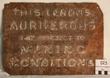
Gold Mining Sign
This sign was required to be displayed in the vicinity of gold mining sites. Myrtleford district was known to have had 100 sites within a ten mile radius of the town; the sign was recovered by Charlie McFadyen, a local prospector and fossicker, of some 60 yearsThe sign relates to local gold mining activity, a key source of wealth and employment from 1854 to the late 19th century. Such signs continued to be in use during the period between World War 1 and 2,including the period of the Great Depression.Tin rectangular mining sign embossed with a warningInscription: "THIS LAND IS AURIFEROUS AND SUBJECT TO MINING CONDITIONS"auriferous mining -
 Puffing Billy Railway
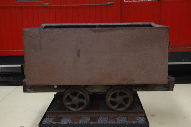
Wonthaggi Coal Skip, Early 20th century
One of two types of four wheel skips widely used on the Wonthaggi Coal Fields for transportation from the underground workings to the surface screening and loading areas. Haulage underground was accomplished by the use of pit ponies, whilst an endless rope system was used to bring the skips to the surface areas. Much of the coal for the colony of Victoria was sourced from Newcastle and the Hunter Region in New South Wales, along with local supplies from private and co-operative coal mines at Outtrim, Jumbunna and Korumburra in Gippsland. After the 1909–1910 strike by coal miners in the Hunter Valley, the Victorian state government were determined to ensure stability in local supplies of coal. The State Coal Mine and the town of Wonthaggi came into being in 1910 to supply coal for the Victorian Railways. It was one of the largest and most dangerous collieries in Australia. At its peak in 1926 the mine produced 2,435 long tons (2,474 t) per day, with the Victorian Railways buying 90% of production. In 1928, Wonthaggi coal accounted for around 60% of Victorian Railways coal consumption.Historic - Industrial - Victorian Railways - Narrow Gauge Railway rolling stock - Wonthaggi Coal Fields, Victoria, AustraliaRectangular steel bin with wood frame and steel wheelspuffing billy, coal skip, wonthaggi, wonthaggi coal fields, 2'0" gauge, brown coal -
 Puffing Billy Railway
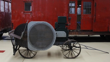
New Record Saw Bench, circa 1930's
Saw Bench - New Record Saw Bench Timber framed with steel wheels, belt driven saw blade powered by a Rosbery internal combustion engine. The Rosebery Engine No C28437 R.P.M 800 H.P. 6 Manufactured By Westinghouse Rosebery Pty.Ltd. Sydney Rosebery Engine Works Ltd began as the engine and pump manufacturing division of Buzacott & Company, and in 1923 became an incorporated company. In 1935, Westinghouse gave Rosebery Engine Works the right to manufacture and sell nearly all Westinghouse products. The name of the company then changed to Westinghouse Rosebery Ltd From the late nineteenth century, petrol engines gradually supplanted steam engines for running a wide range of machines, and in turn petrol engines were largely supplanted by electric motors. The Champion was a successful small petrol engine made by the large Sydney company, Westinghouse Rosebery, based on the American-designed Fuller and Johnson engine. With hopper cooling and a fuel tank between the skids, and weighing only 240 pounds (109 kg), it was easy to mount on wheeled transport, making the Champion a self-contained mobile source of power. Engines of this type were used in rural areas for driving chaff cutters, small saw benches, pumps and orchard sprayers. These engines were also commonly used in both rural and urban areas for powering concrete mixers. Both Westinghouse Rosebery in NSW and Toowoomba Foundry in Queensland made these engines in large quantities, beginning in the 1920s when tariff protection made local manufacturing viable. The production of small petrol engines continued in Australia until the 1970s, when reduced tariff protection led to increased competition from cheaper imported engines. Historic - Industrial Timber working - belt driven saw blade powered by a Rosbery internal combustion engine. Timber framed with steel wheels, belt driven saw blade powered by a Rosbery internal combustion engine. The Rosebery Engine No c28437 R.P.M 800 H.P. 6 Manufactured By Westinghouse Rosebery Pty.ltd. Sydneysaw bench, puffing billy, new record, internal combustioin, westinghouse rosebery pty.ltd., rosebery pty, internal combustion engine. -
 Tatura Irrigation & Wartime Camps Museum
Book, A German Church in the Garden of God, 2004
Published for 150 years of Melbourne Trinity Lutheran Church, 1853-2003, not only as a source of reference and awareness about its own background but also as an incentive and motivation for continued active engagement of a large membershipCharcoal grey to beige at the top, of a hard cardboard cover book. Cover depicts Melbourne 1887 and title in black text. Back cover depicts "The Sower" window donated in 2004. 2 copiesPresented to Tatura & District historical Society In. with the compliments of Trinity Lutheran Church of Melbourne.luthern church, melbourne, mees hd, steiniger d, steiniger h, rechner p, camps, tatura, ww2, lutheran church, books, history, local -
 Victorian Aboriginal Corporation for Languages
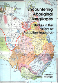
Book, William B McGregor, Encountering Aboriginal languages : studies in the history of Australian linguistics, 2008
"This edited volume represents the first book-length study of the history of research on Australian Aboriginal languages, and collects together 18 original papers on a wide variety of topics, spanning the period from first settlement to the present day. The introduction sets the scene for the book by presenting an overview of the history of histories of research on the languages of Australia , and identifying some of the major issues in Aboriginal linguistic historiography as well as directions for future investigations. Part 1 presents three detailed investigations of the history of work on particular languages and regions.The eight papers of Part 2 study and re-evaluate the contributions of particular individuals, most of who are somewhat marginal or have been marginalised in Aboriginal linguistics. Part 3 consists of six studies specific linguistic topics: sign language research, language revival, pidgins and creoles, fieldwork, Fr. Schmidt's work on personal pronouns, and the discovery that Australia was a multilingual continent. Overall, the volume presents two major challenges to Australianist orthodoxy. First, the papers challenge the typically anachronistic approaches to the history of Aboriginal linguistics, and reveal the need to examine previous research in the context of their times - and the advantages of doing so to contemporary understanding and language documentation. Second, the widespread presumption that the period 1910-1960 represented the 'dark ages' of Aboriginal linguistics, characterised by virtually no linguistic work, is refuted by a number of studies in the present volume."B&w photographs, maps -
 Victorian Aboriginal Corporation for Languages
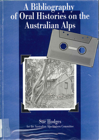
Book, Sue Hodges, A bibliography of oral histories on the Australian Alps, 1996
... Street Brunswick melbourne historiography Australian Alps history ...Covers 465 oral history interviews contained in a number of collections: - Kosciusko Huts Committee collection, Matthew Higgins collection, Peter Read collection, Ruth Lane collection, Sue Hodges collection, Tor and Jane Holth collection, Klaus Hueneke collection, Siobhan McHugh collection, National Parks and Wildlife Service collection, Stockman's Hall of Fame collection, Timothy Lee collection, Lesley Alves collection, Sue Wesson collection, unavailable collections.b&w photographs, tableshistoriography, australian alps history, victorian history -
 Victorian Aboriginal Corporation for Languages
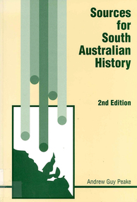
Book, Andrew Guy Peake, Sources for South Australian history, 1998
document reproductions, posterssouth australia, genealogy, local history, bibliographies, public records, land records, family history -
 Sunshine and District Historical Society Incorporated
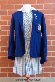
School Uniform, Blazer - Mark Anttony Schoolwear, SUNSHINE WEST HIGH SCHOOL, 1960's
Sunshine West High School started in 1960 with classes held in the old church and the church hall of St Mark's Anglican Church, Sunshine, Victoria, 3020. The school transferred to Lachlan Road, West Sunshine when the new building was completed. In 1961 the proportion of students from European background was almost 52% and those of British-Australian almost 48%. By 1965 the number of students totalled 699, with 28 of them being the first to do the Form 6 (Year 12) Matriculation exam. By 1969 the number of students had increased to the point that some classes were held in shelter sheds. In 1992 the multi campus Sunshine College was formed through the amalgamation and restructure of six schools: Sunshine West High School, Sunshine Technical School, Ardeer High School, North Sunshine Technical School, Sunshine High School, and Tottenham Technical School. The last two school sites were closed and are now occupied by Victoria University and the Tottenham English Language Centre respectively. Sunshine West High School became the junior West Campus of Sunshine College. The style of school uniform displayed here is not used by the Sunshine College. The girls had two sets of uniforms, one for the summer and one for the winter. The frock and blazer (as displayed) were for the summer but a grey straw hat, grey socks, and black shoes were also part of the compulsory uniform. The displayed grey v-necked jumper could be worn in both summer and winter. The winter outfit consisted of a blue shirt, a tie (as displayed), a grey box pleated tunic, blazer, grey stockings, black shoes, a blue felt hat and grey gloves. Of particular interest is that the boys did not have to wear the feminine looking style of grey jumper with the pink and blue stripes. They wore a dark blue jumper. There was a 'uniform inspection' carried out after the Monday morning assembly and the Prefects had the task of policing students to make sure that they wore the full complement of items, both to and from school. The 3 badges indicate that the female student was a member of the School Council, which had replaced the Prefects around 1969 or 1970, and she was also Captain of one of the 4 Sports Houses and of her Form. Sources of information: (1) http://www.sunshine.vic.edu.au/history.htm (accessed 4/11/2015). (2) Book - 'Harvester City' by Olwen Ford (page 412). (3) Discussions with two former students.Sunshine West High School played a significant part in the secondary education of local children, however the school had a relatively short life span in its own right during the latter part of the twentieth century. The items of girls school uniform, the school insignia, and the 3 metal badges serve as a historical reminder of the previous existence of the school, and of the colours and designs of these items.Four items of girls school uniform plus 3 metal badges: (1) Dark blue blazer with school insignia on the left breast pocket. (2) Blue and white striped frock. (3) Light grey v-necked jumper with dark blue, light blue, and pink stripes around the neck and the cuffs. (4) Dark blue tie with light blue and pink diagonal stripes. The 3 badges are School Captain, House Captain, and Form Captain.Insignia on blazer - SWHS / COURAGE AND WISDOMsunshine west high school, girls school uniform, carland, blazer, frock, school jumper, swhs, courage and wisdom, junior campus, west campus, sunshine college, 1960, 1991 -
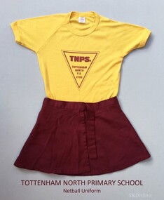 Sunshine and District Historical Society Incorporated
Sports Uniform (Netball) - TOTTENHAM NORTH PRIMARY SCHOOL, 'Ryder' Brand T-Shirt, Early to mid 1980's
This Netball uniform from circa 1986 was worn by a girl named Rebecca when she attended the Tottenham North Primary School. Tottenham North Primary School was opened on 29 May 1953 and was built on a South Road, Braybrook site purchased in 1929. After a fire in February 1961 the pupils were sent to the Powell and Curtin Street schools in Yarraville, and to the Maidstone and Sunshine East schools. The new building was officially opened on 22 August 1962 by A. McDonell, Director of Education, and it had sixteen classrooms, an art/craft room, and an assembly hall. Sporting achievements by the pupils included the 1963 football premiership and the 1968 cricket premiership. Over the years it has been called Tottenham Primary, Tottenham Crossing Primary, and Maidstone Primary. The different names resulted because of mergers with other local primary schools as the number of primary aged children in the Braybrook and Tottenham area changed. The school on South Road is now named Dinjerra Primary School. Dinjerra supposedly means 'out west' in the dialect of the original indigenous people of the area. Dinjerra Primary School is now the only neighbourhood government primary school in Braybrook Tottenham. The above information was sourced and compiled from: 1. 'Vision and Realisation - A Centenary History of State Education in Victoria - Volume 3', Education Department of Victoria 1973. 2. The Dinjerra Principal's website article at: http://www.dinjerra.vic.edu.au/91/Message-from-the-Principal.The netball uniform serves as a historic reminder that a school named Tottenham North Primary School once existed. The uniform also provides us with information of the colours used on these types of sports uniforms, and of the design of the School Logo.Two items of Netball Uniform. (a) Skirt - Maroon coloured wrap around sports skirt. (b) T-shirt - Yellow, Size 14 'Ryder' brand children's T-shirt, with maroon coloured triangular shaped School Logo printed on the front.TNPS. TOTTENHAM NORTH P.S. 4703 - (Printed inside triangle)sports uniform, netball skirt, netball t-shirt, tottenham north primary school, south road braybrook, tottenham primary school, maidstone primary school, tottenham crossing school, dinjerra primary school, tottenham north state school, state school 4703 -
 Yackandandah & District Historical Society
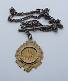
Medal - Bryson's Medal, Aronson & Co
The Medal was won by WJ Mahon, Best Bowling Average, Yackandandah Cricket Association 1923-1924' It was donated to Yackandandah Cricket Club by Mrs Evelyn Drummond, daughter of William James Mahon. An Allans Flat cricketer, Jim Mahon was a third-generation Allan's Flat/ Osborne's Flat resident. His father, Henry, keenly followed football and cricket. His son, Mervyn, Captained Yackandandah in cricket and served as Club Treasurer. Jim, like Merv, represented his association at Country Week Cricket. (notes accompanying medal on donation - source Yack Cricket Club)The item is of local significance, in the story of cricket in Yackandandah. Cricket has been played in the district since 1860, and the Medal was an important exhibit in a celebration of 150 years of cricket in Yackandandah, 2010. The medal is a good example of a practice used in the creation of trophies, where a base item is created, and a sport-specific item added. In this case the addition is a representation of a cricketer, with arm aloft, ie a bowler. Cavell, 1990, observes that Aronson & Co used this to create medals/medalets for a variety of sports, and includes a selection of images of different bases to which representations of different sports are added. Another example is the Woy Woy Champion 1925 awarded to cyclist K. Ross, held by the National Museum of Australia. The same practice is used extensively now, albeit in plastic and synthetic wood, rather than gold.Gold, wreath shaped fob medallion/medalet. Central circle (attached as a separate item) shows cricketer holding aloft a ball. Back engraved. Attached to silver-coloured, metal link chain with bar and hook fastener. Won by WJ Mahon, Best Bowling Average, Yackandandah Cricket Association, 1923-24 season.Bryson's Medal / won by / W.J. Mahon / Best Bowling Avg / Yack Assn / 1923'24. Marks: maker's mark (Aronson & Co), 9, sheaf of wheat; PT APPFORsport, trophies -
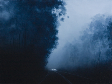 Nillumbik Shire Council
Painting: Camilla TADICH, Camilla Tadich, 6.23am Kangaroo Ground, 2009
Tadich spends time observing night time phenomena, the light from the moon, street lights and other sources; atmospheric states, fog and dampness and the nature of surfaces, vegetation, road, vehicles and buildings. She uses photographs and sketches before settling on the final idea for a work.This painting is typical of Tadich's recent work. She continues her exploration of the Australian landscape (most often the local, Nillumbik Shire). It is 'a dramatic interplay between narrative, landscape and the binaries of light/dark and the known/unknown of local landscape. The swathes of darkness within the work(s) pose questions about our inscribed fears and tensions, both cultural and existential'. (catalogue, 'Silent Space' Ex. 2006) Tadich's early experiences of fireworks, simple fireworks and bonfire in the surrounding bush of her outer Melbourne home, caught her imagination. She was inspired to investigate the issues surrounding nights in the bush. In this painting the narrative is ambiguous, the pinpricks of light, in this case from the car headlights provide a critical element. We can distinguish familiar features, a road, trees and a car that suggest human presence. However, what is going on is unclear. The resulting tension can leave us unsure, unsettled and anxious.Oil on canvascamilla tadich, nillumbik shire council, kangaroo ground -
 Peterborough History Group
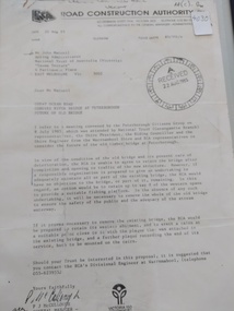
Document - Three letters pertaining to the retention of the Old Bridge
Upon confirmation that a new bridge was to be built, there was some discussion about the possibility of retaining the old bridge for pedestrian purposes, or part of the old bridge as a fishing platform. These letters are part of the correspondence re an organisation taking responsibility for the ongoing maintenance so the old bridge could be retained.The old bridge was constructed of locally sourced timber and was such an important structure to the town when built. Its sentimental value saw locals attempt (although unsuccessfully) to retain the old bridge.Two A4 Typewritten letters, one from the Road Construction Authority to the National Trust Australia, the other from the Department of Conservation Forests & Lands to Mr John Irvine. And one hand written letter.RCA letter is stamped "Received 22 Aug 1985", Dept of Conservation Forests & Lands has a pencilled phone no inscribed.peterborough, curdies river bridge, old peterborough bridge, department of conservation forest & lands, road construction authority -
Whitehorse Historical Society Inc.
Document, Notes on Box Hill and Nunawading, c1972
Covers various interviews and extracts from sourcesCovers various interviews and extracts from sourcesCovers various interviews and extracts from sourceslocal history, leach, nancy, walker, g. e., box hill, east burwood methodist church, lowan, walter, edward street, mitcham, no 9, middleborough road, blackburn, no 372, mount pleasant road, nunawading, no 129, lucknow street, mitcham, no 58, wolseley crescent, blackburn, no 7 -
Whitehorse Historical Society Inc.
Document, Statement of revenue, 1933, 1933
Shire of Blackburn and Mitcham statement of revenue from all source for the year ended 30 Sep 1933 compiled for the purposes of ascertaining the revenue basis for salaries etcShire of Blackburn and Mitcham statement of revenue from all source for the year ended 30 Sep 1933 compiled for the purposes of ascertaining the revenue basis for salaries etcShire of Blackburn and Mitcham statement of revenue from all source for the year ended 30 Sep 1933 compiled for the purposes of ascertaining the revenue basis for salaries etclocal government, shire of blackburn and mitcham, financial documents -
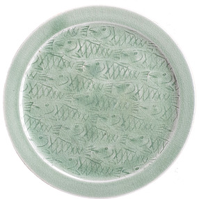 Ballarat Heritage Services
Ceramic - Studio Pottery, John Gleeson, Ceramic Platter, 2007
John GLEESON Living at Campbell's Creek for over 30 years, John Gleeson makes a range of functional stoneware pottery. He fell in loved with pottery during a hobby class in Geelong in 1972. He worked for a year at Canny Ridge Pottery in Harcourt. John Gleeson uses white stoneware and porcelain clay from The Bendigo Pottery, and buff clay from Bennetts Pottery in Adelaide. He mixed all his own glazes from commercially sourced raw materials, sometimes supplemented with ash from his fire and local red clay to get special effects.Large celadon platter with incised fish design. john gleason, studio pottery, ceramics, australian studio pottery -
Unions Ballarat
Book - Australian Labour History (D.J. Spiers Collection), Patmore, Gred
Australian Industrial Relations series. Chapter headings: 1. Australian labour history 2. Convicts and free labour 1788-1850 3. A working man's paradise? Labour 1850-91 4. Labour and politics 1891-1957 5. Labour and the state: Compulsory arbitration and wages boards 1890-1914 6. Labour and capital: The labour process in Australia before 1972 7. Gender and work: Feminist labour historiography and equal pay in Australia 8. Race, ethnicity and work: Australia 1788-1972Significant to labour relations and unions in Australia.Book; paper.Front cover: Author's name and title. btlc, ballarat trades and labour council, history - labour