Showing 2091 items matching "gold districts"
-
 Wodonga & District Historical Society Inc
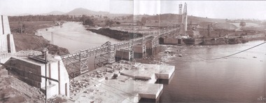
Album - Hume Reservoir Australia Album - General View of Works from New South Wales end, Looking Upstream, August 1927
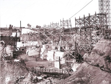
This set of photos is from a leather bound album bearing the inscription "HUME RESERVOIR AUSTRALIA" plus 'The Rt. Hon. L. C. M. S. Amery, P. C., M .P.' all inscribed in gold. It was presented to The Rt. Hon. L. C. M. S. Amery, P. C., M. P, Secretary of State for Dominion Affairs on the occasion of his visit to the Hume Reservoir on 2nd November 1927. This album is of local and national significance as it documents the planning and development of the Hume Reservoir up to 1927. It was the largest water reservoir in the British Empire. The album records the pioneering engineering work that went into its construction.DEPARTMENT OF PUBLIC WORKS, N.S.W. RIVER MURRAY WATERS SCHEME. HUME RESERVOIR. 22. General View of Works from New South Wales end, Looking Upstream. Features: At the left, part of the North Wing Wall, the highest part of which is 26 feet below its ultimate height. Below in the foreground is the portion of the dam where provision is to be made for hydro-electric generation. The tubes, three in number, 13 feet in diameter, will be laid on the level shown and an early start will be made in laying them. The level for the other four regulating outlets, 9 feet in diameter, together with a part of the spillway section of the dam, is underwater at this stage and it may be remarked that at one point, about half way across the channel where the water is now flowing, the concrete foundations are about 80 feet below the level of the water. The broken surface of the water is due to the large “plums” in the concrete. The still water in the right foreground is the stilling pool over the concrete floor of which there is now more than 20 feet of water and by means of which the discharge from the outlet pipes will be quelled. The trestlework on the upstream side of the dam carries the concrete belt conveyor. It extends from the concrete mixer house, which is out of the picture, behind the wing wall, along almost the entire length of the concrete portion of the dam. The concrete is discharged from the belt at any desired point by means of trippers, one of which may be seen over the second trestle. On the other side of the flowing water is the coffer dam. A channel 300 feet wide involving about 140,000 cubic yards of excavation and dug for the temporary diversion of the river as it is flowing now. To the right top of the view beyond the Coffer Dam is the earth embankment being thrown across the major part of the valley by the Victorian Constructing Authority. The Mitta Mitta River flows into the Murray at the far end of the reach of water on the left. August 1927.hume reservoir australia, river murray waters scheme, hume reservoir construction -
 Wodonga & District Historical Society Inc
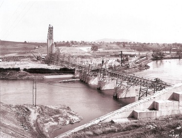
Album - Hume Reservoir Australia Album - General View of Works from New South Wales end, Looking Upstream, August 1927
This set of photos is from a leather bound album bearing the inscription "HUME RESERVOIR AUSTRALIA" plus 'The Rt. Hon. L. C. M. S. Amery, P. C., M .P.' all inscribed in gold. It was presented to The Rt. Hon. L. C. M. S. Amery, P. C., M. P, Secretary of State for Dominion Affairs on the occasion of his visit to the Hume Reservoir on 2nd November 1927. This album is of local and national significance as it documents the planning and development of the Hume Reservoir up to 1927. It was the largest water reservoir in the British Empire. The album records the pioneering engineering work that went into its construction.DEPARTMENT OF PUBLIC WORKS, N.S.W. RIVER MURRAY WATERS SCHEME. HUME RESERVOIR. 23. General view of works from the New South Wales end, looking downstream. The features are generally speaking the same as in the last view 22 (Record WHS 00716) in reverse.hume reservoir australia, river murray waters scheme, hume reservoir construction -
 Wodonga & District Historical Society Inc
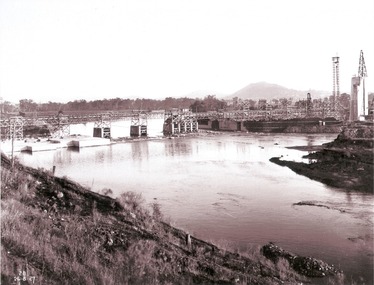
Album - Hume Reservoir Australia Album - View looking upstream, August 1927
This set of photos is from a leather bound album bearing the inscription "HUME RESERVOIR AUSTRALIA" plus 'The Rt. Hon. L. C. M. S. Amery, P. C., M .P.' all inscribed in gold. It was presented to The Rt. Hon. L. C. M. S. Amery, P. C., M. P, Secretary of State for Dominion Affairs on the occasion of his visit to the Hume Reservoir on 2nd November 1927. This album is of local and national significance as it documents the planning and development of the Hume Reservoir up to 1927. It was the largest water reservoir in the British Empire. The album records the pioneering engineering work that went into its construction.DEPARTMENT OF PUBLIC WORKS, N.S.W. RIVER MURRAY WATERS SCHEME. HUME RESERVOIR. 24. Another view looking upstream. August 1927.hume reservoir australia, river murray waters scheme, hume reservoir construction -
 Wodonga & District Historical Society Inc
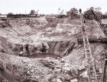
Album - Hume Reservoir Australia Album - Work proceeding inside the coffer dam, August 1927
This set of photos is from a leather bound album bearing the inscription "HUME RESERVOIR AUSTRALIA" plus 'The Rt. Hon. L. C. M. S. Amery, P. C., M .P.' all inscribed in gold. It was presented to The Rt. Hon. L. C. M. S. Amery, P. C., M. P, Secretary of State for Dominion Affairs on the occasion of his visit to the Hume Reservoir on 2nd November 1927. This album is of local and national significance as it documents the planning and development of the Hume Reservoir up to 1927. It was the largest water reservoir in the British Empire. The album records the pioneering engineering work that went into its construction.DEPARTMENT OF PUBLIC WORKS, N.S.W. RIVER MURRAY WATERS SCHEME. HUME RESERVOIR. 25. Work proceeding inside the Coffer Dam. This shows the curving downstream face of the Spillway section taking shape, the bottom edge being the line of the contraction joint between the wall and the energy dissipater which has still to be built. Note the steam navvy at the end of the bit of curved work ready to take out the foundations for the energy dissipater. The tall concrete pillar is a portion of the work at the intersection of the main and south wing walls which was built in advance of the rest of the work to accommodate the tail tower of the cableway. The Tail Tower for the first stages of the work stood on the ground. Part of it is seen erected on the pillar while part of it is still in its original position. To command the concreting of the pillar end of the south wing wall a twin hoist tower of steel construction was erected at the end of the belt conveyor. This hoist is 160 feet high. The belt conveyor will at a later stage be raised for the concreting of the upper portion of the dam and the trestles are now being built up for that purpose. A drag line excavator with a 2 cubic yard capacity bucket is at work near the tail tower on the foundations for the south wing wall. New South Wales, August 1927.hume reservoir australia, river murray waters scheme, hume reservoir construction -
 Wodonga & District Historical Society Inc
Album - Hume Reservoir Australia Album - Work proceeding inside the coffer dam (2), August 1927
This set of photos is from a leather bound album bearing the inscription "HUME RESERVOIR AUSTRALIA" plus 'The Rt. Hon. L. C. M. S. Amery, P. C., M .P.' all inscribed in gold. It was presented to The Rt. Hon. L. C. M. S. Amery, P. C., M. P, Secretary of State for Dominion Affairs on the occasion of his visit to the Hume Reservoir on 2nd November 1927. This album is of local and national significance as it documents the planning and development of the Hume Reservoir up to 1927. It was the largest water reservoir in the British Empire. The album records the pioneering engineering work that went into its construction.DEPARTMENT OF PUBLIC WORKS, N.S.W. RIVER MURRAY WATERS SCHEME. HUME RESERVOIR. 26. Work proceeding inside the coffer dam. This view was taken from the edge of the cut for the South Wing Wall foundations looking from the opposite direction to that of the preceding photograph, the curving downstream face of the main wall being seen beyond the steam navvy. This view shows the way in which the concrete paddocks are stepped and broken jointed vertically and horizontally. In the distance is the North Wing Wall and Power House stack beyond it. New South Wales, August 1927.hume reservoir australia, river murray waters scheme, hume reservoir construction -
 Wodonga & District Historical Society Inc
Album - Hume Reservoir Australia Album - Preparing a paddock for concrete. August 1927
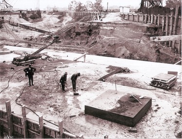
This set of photos is from a leather bound album bearing the inscription "HUME RESERVOIR AUSTRALIA" plus 'The Rt. Hon. L. C. M. S. Amery, P. C., M .P.' all inscribed in gold. It was presented to The Rt. Hon. L. C. M. S. Amery, P. C., M. P, Secretary of State for Dominion Affairs on the occasion of his visit to the Hume Reservoir on 2nd November 1927. This album is of local and national significance as it documents the planning and development of the Hume Reservoir up to 1927. It was the largest water reservoir in the British Empire. The album records the pioneering engineering work that went into its construction.DEPARTMENT OF PUBLIC WORKS, N.S.W. RIVER MURRAY WATERS SCHEME. HUME RESERVOIR. 27. Preparing a Paddock for Concrete. Great care is taken in cleaning the surface of the concrete before placing the next layer. A hose applies a jet of water with a pressure of about 150 pounds to remove laitance and all dirt, which is swept off with brooms. (Laitance is the weak, milky or powdery layer of cement dust, lime and sand fines that appear on the surface of concrete. ) The square block of concrete in the foreground is poured at the same time as the concrete surrounding it and acts as a key for the next layer. Usually large granite “plums” or displacers weighing from 2 tons to 8 tons are used for this purpose and are placed in position by the cableway, but while the cableway is out of action the other method has been adopted. In this view may also be seen some of the timber piles and sheeting which form the inner side of the coffer dam. The outer side is formed of steel sheet piling. The space between the two lines of piles is 20 feet wide and is filled with earth after the steel and timber lines have been bound together by steel tie rods. New South Wales, August 1927.hume reservoir australia, river murray waters scheme, hume reservoir construction -
 Wodonga & District Historical Society Inc
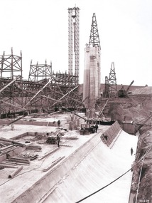
Album - Hume Reservoir Australia Album - Concrete pillar for tall tower, New South Wales, August 1927
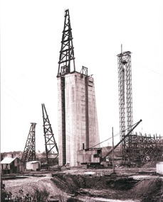
This set of photos is from a leather bound album bearing the inscription "HUME RESERVOIR AUSTRALIA" plus 'The Rt. Hon. L. C. M. S. Amery, P. C., M .P.' all inscribed in gold. It was presented to The Rt. Hon. L. C. M. S. Amery, P. C., M. P, Secretary of State for Dominion Affairs on the occasion of his visit to the Hume Reservoir on 2nd November 1927. This album is of local and national significance as it documents the planning and development of the Hume Reservoir up to 1927. It was the largest water reservoir in the British Empire. The album records the pioneering engineering work that went into its construction.DEPARTMENT OF PUBLIC WORKS, N.S.W. RIVER MURRAY WATERS SCHEME. HUME RESERVOIR. 28. Concrete Pillar for Tail Tower. This shows the back and upstream side of the tower. The groove at the back is left for the reception of the concrete core wall of the earth embankment. The groove is being used at present as a hoist well, up and down which men and materials are conveyed in connection with the re-erection of the Tail Tower of the cableway. The pillar is 108 feet from the ground and is within 4 feet of its ultimate height. The foundation of this part at its deepest is 90 feet below the natural surface so that when the 80 feet tower and jury mast are in place the total height from foundation to top of mast will be about 300 feet. New South Wales, August 1927.hume reservoir australia, river murray waters scheme, hume reservoir construction -
 Wodonga & District Historical Society Inc
Album - Hume Reservoir Australia Album - View of concrete dam from top of tall tower pillar, August 1927
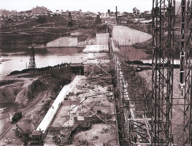
This set of photos is from a leather bound album bearing the inscription "HUME RESERVOIR AUSTRALIA" plus 'The Rt. Hon. L. C. M. S. Amery, P. C., M .P.' all inscribed in gold. It was presented to The Rt. Hon. L. C. M. S. Amery, P. C., M. P, Secretary of State for Dominion Affairs on the occasion of his visit to the Hume Reservoir on 2nd November 1927. This album is of local and national significance as it documents the planning and development of the Hume Reservoir up to 1927. It was the largest water reservoir in the British Empire. The album records the pioneering engineering work that went into its construction.DEPARTMENT OF PUBLIC WORKS, N.S.W. RIVER MURRAY WATERS SCHEME. HUME RESERVOIR. 29. View from Top of Tail Tower Pillar - Concrete Dam. This was taken from the top of the Tower described in the preceding photograph looking towards New South Wales. (WHS 00722) First is the part of the spillway being built inside the Coffer Dam, then over the Coffer Dam the submerged portion of the Spillway and outlet sections for the river diversion, beyond that the situation for the hydro-electric turbo passages bounded by the North Wing Wall. The gap may be seen in wing wall for the passage of the belt conveyor and half of the concrete mixer house behind. This gives a general view of the New South Wales Township. The Quarry is on the side of the hill showing up beyond the Township. New South Wales, August 1927.hume reservoir australia, river murray waters scheme, hume reservoir construction -
 Wodonga & District Historical Society Inc
Album - Hume Reservoir Australia Album - View of South Wing Wall Foundations from Top of Tail Tower Pillar, August 1927
This set of photos is from a leather bound album bearing the inscription "HUME RESERVOIR AUSTRALIA" plus 'The Rt. Hon. L. C. M. S. Amery, P. C., M .P.' all inscribed in gold. It was presented to The Rt. Hon. L. C. M. S. Amery, P. C., M. P, Secretary of State for Dominion Affairs on the occasion of his visit to the Hume Reservoir on 2nd November 1927. This album is of local and national significance as it documents the planning and development of the Hume Reservoir up to 1927. It was the largest water reservoir in the British Empire. The album records the pioneering engineering work that went into its construction.DEPARTMENT OF PUBLIC WORKS, N.S.W. RIVER MURRAY WATERS SCHEME. HUME RESERVOIR. 30. View from Top of Tail Tower Pillar - South Wing Wall Foundations. This photograph was taken at right angles to the preceding one, (WHS 00723) ooking downstream along the cut for the South Wing Wall foundation. The granite is at a greater depth here than elsewhere and the cut will be twice as deep before the foundations are cleared. New South Wales. August 1927.hume reservoir australia, river murray waters scheme, hume reservoir construction -
 Wodonga & District Historical Society Inc
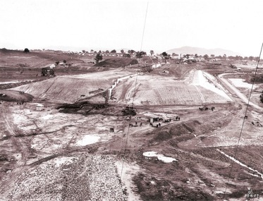
Album - Hume Reservoir Australia Album - Earth embankment on Victorian side from Top of Tail Tower Pillar, August 1927
This set of photos is from a leather bound album bearing the inscription "HUME RESERVOIR AUSTRALIA" plus 'The Rt. Hon. L. C. M. S. Amery, P. C., M .P.' all inscribed in gold. It was presented to The Rt. Hon. L. C. M. S. Amery, P. C., M. P, Secretary of State for Dominion Affairs on the occasion of his visit to the Hume Reservoir on 2nd November 1927. This album is of local and national significance as it documents the planning and development of the Hume Reservoir up to 1927. It was the largest water reservoir in the British Empire. The album records the pioneering engineering work that went into its construction.DEPARTMENT OF PUBLIC WORKS, N.S.W. RIVER MURRAY WATERS SCHEME. HUME RESERVOIR. 31. View from Top of Tail Tower Pillar - Earth Embankment, Victoria. This is a general view of the embankment which is being constructed by the Victorian Constructing Authority. The bank at its base is about 650 feet wide and it is about half its ultimate height. In the middle is the reinforced concrete core wall. At about the natural surface a tunnel for drainage and inspection purposes is built along the downstream side of the core wall but this cannot be seen. The Victorian workshops and township are located on the high ground beyond the embankment. The embankment curves round to the left at the side of the valley and will eventually block the gulley where the bushy tree stands. Access to one of the cuttings from which material is being got for the embankment is gained by means of this gulley at present. Part of another cutting may be seen on the right hand side at the back. August 1927.hume reservoir australia, river murray waters scheme, hume reservoir construction -
 Wodonga & District Historical Society Inc
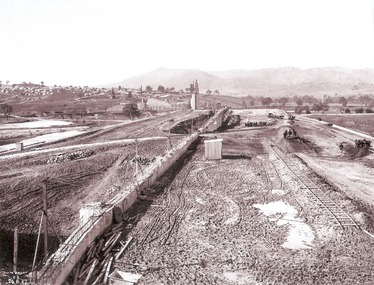
Album - Hume Reservoir Australia Album - Earth embankment, Victoria, August 1927
This set of photos is from a leather bound album bearing the inscription "HUME RESERVOIR AUSTRALIA" plus 'The Rt. Hon. L. C. M. S. Amery, P. C., M .P.' all inscribed in gold. It was presented to The Rt. Hon. L. C. M. S. Amery, P. C., M. P, Secretary of State for Dominion Affairs on the occasion of his visit to the Hume Reservoir on 2nd November 1927. This album is of local and national significance as it documents the planning and development of the Hume Reservoir up to 1927. It was the largest water reservoir in the British Empire. The album records the pioneering engineering work that went into its construction.DEPARTMENT OF PUBLIC WORKS, N.S.W. RIVER MURRAY WATERS SCHEME. HUME RESERVOIR. 32. Earth Embankment, Victoria. Looking down on the earth embankment and core wall. The earth is conveyed to the bank by rail, tipped out and then put in place by wheeled scoops, the horses and wheels treading and rolling the material into a very compact form while hoses play water on the mass to keep it moist. The concrete pillar with Tail Tower, and North Wing Wall, look very small in the distance. August 1927.hume reservoir australia, river murray waters scheme, hume reservoir construction -
 Wodonga & District Historical Society Inc
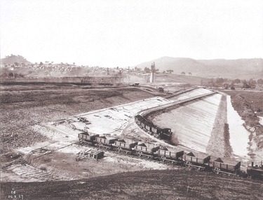
Album - Hume Reservoir Australia Album - Concrete Slabs on embankment, August 1927
This set of photos is from a leather bound album bearing the inscription "HUME RESERVOIR AUSTRALIA" plus 'The Rt. Hon. L. C. M. S. Amery, P. C., M .P.' all inscribed in gold. It was presented to The Rt. Hon. L. C. M. S. Amery, P. C., M. P, Secretary of State for Dominion Affairs on the occasion of his visit to the Hume Reservoir on 2nd November 1927. This album is of local and national significance as it documents the planning and development of the Hume Reservoir up to 1927. It was the largest water reservoir in the British Empire. The album records the pioneering engineering work that went into its construction.DEPARTMENT OF PUBLIC WORKS, N.S.W. RIVER MURRAY WATERS SCHEME. HUME RESERVOIR. 33. Concrete Slabs on Embankment. The upstream face of the embankment is being protected from the effects of wave action by concrete slabs 12 inches thick laid in squares in situ. The thrust at the toe of the bank is taken care of by a body of granite blocks and spalls. Victoria. August 1927.hume reservoir australia, river murray waters scheme, hume reservoir construction -
 Wodonga & District Historical Society Inc
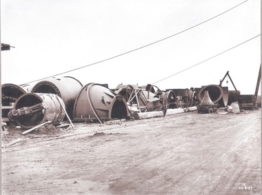
Album - Hume Reservoir Australia Album - Needle valves, August 1927
This set of photos is from a leather bound album bearing the inscription "HUME RESERVOIR AUSTRALIA" plus 'The Rt. Hon. L. C. M. S. Amery, P. C., M .P.' all inscribed in gold. It was presented to The Rt. Hon. L. C. M. S. Amery, P. C., M. P, Secretary of State for Dominion Affairs on the occasion of his visit to the Hume Reservoir on 2nd November 1927. This album is of local and national significance as it documents the planning and development of the Hume Reservoir up to 1927. It was the largest water reservoir in the British Empire. The album records the pioneering engineering work that went into its construction.DEPARTMENT OF PUBLIC WORKS, N.S.W. RIVER MURRAY WATERS SCHEME. HUME RESERVOIR. 34. Needle Valves. Some of the needle valves in parts stacked ready for removal by the cableway to their positions on the outlets. There are seven of these, 7 feet 6 inches in diameter. The heaviest single part weighs about 10 tons. New South Wales. August 1927. A needle valve is a type of valve which can be used to regulate flow of a substance, usually either gas or water, through an appliance or system. The unique feature of the value is the inclusion of a small plunger, with a shape akin to a needle.hume reservoir australia, river murray waters scheme, hume reservoir construction -
 Wodonga & District Historical Society Inc
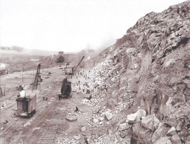
Album - Hume Reservoir Australia Album - View along the face of the quarry, August 1927
This set of photos is from a leather bound album bearing the inscription "HUME RESERVOIR AUSTRALIA" plus 'The Rt. Hon. L. C. M. S. Amery, P. C., M .P.' all inscribed in gold. It was presented to The Rt. Hon. L. C. M. S. Amery, P. C., M. P, Secretary of State for Dominion Affairs on the occasion of his visit to the Hume Reservoir on 2nd November 1927. This album is of local and national significance as it documents the planning and development of the Hume Reservoir up to 1927. It was the largest water reservoir in the British Empire. The album records the pioneering engineering work that went into its construction.DEPARTMENT OF PUBLIC WORKS, N.S.W. RIVER MURRAY WATERS SCHEME. HUME RESERVOIR. 35. Quarry. View along the face of the quarry. Granite is being quarried here for the concrete material. Blocks from 2-8 tons in weight are reserved for “plums”. Quantities of large size spalls are sent to Victoria for the toe of the embankment and other purposes but the greatest proportion of the stone is crushed at the quarry to 2½ inches gauge for concrete aggregate. Two steam navvies and two steam travelling cranes are at work on the face. New South Wales. August 1927.hume reservoir australia, river murray waters scheme, hume reservoir construction -
 Wodonga & District Historical Society Inc
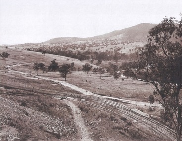
Album - Hume Reservoir Australia Album - Valley of the Murray to be crossed by the Bethanga Bridge 1927
This set of photos is from a leather bound album bearing the inscription "HUME RESERVOIR AUSTRALIA" plus 'The Rt. Hon. L. C. M. S. Amery, P. C., M .P.' all inscribed in gold. It was presented to The Rt. Hon. L. C. M. S. Amery, P. C., M. P, Secretary of State for Dominion Affairs on the occasion of his visit to the Hume Reservoir on 2nd November 1927. This album is of local and national significance as it documents the planning and development of the Hume Reservoir up to 1927. It was the largest water reservoir in the British Empire. The album records the pioneering engineering work that went into its construction.DEPARTMENT OF PUBLIC WORKS, N.S.W. RIVER MURRAY WATERS SCHEME. HUME RESERVOIR. 36. Valley of the Murray to be crossed by the Bethanga Bridge described in the next photograph. (WHS 00731) This view shows the marshalling sidings for trucks below the Quarry, New South Wales, and the branch line to the site of the bridge.hume reservoir australia, river murray waters scheme, hume reservoir construction -
 Wodonga & District Historical Society Inc
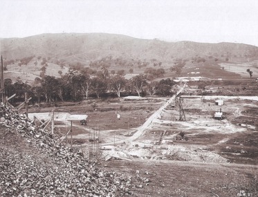
Album - Hume Reservoir Australia Album - Bethanga Bridge Site, August 1927
This set of photos is from a leather bound album bearing the inscription "HUME RESERVOIR AUSTRALIA" plus 'The Rt. Hon. L. C. M. S. Amery, P. C., M .P.' all inscribed in gold. It was presented to The Rt. Hon. L. C. M. S. Amery, P. C., M. P, Secretary of State for Dominion Affairs on the occasion of his visit to the Hume Reservoir on 2nd November 1927. This album is of local and national significance as it documents the planning and development of the Hume Reservoir up to 1927. It was the largest water reservoir in the British Empire. The album records the pioneering engineering work that went into its construction.DEPARTMENT OF PUBLIC WORKS, N.S.W. RIVER MURRAY WATERS SCHEME. HUME RESERVOIR. 37. Bethanga Bridge Site. A bridge is being built to cross the Reservoir to serve a large area of country which will be cut off from its natural outlets by the submergence of existing bridges when the Reservoir is in being. The site of the bridge is nearly a mile up the Murray from the Hume Reservoir Quarry. Its length will be approximately half a mile. There will be nine spans of 269 feet with steel truss girders resting on concrete pillars. Some of the pillars are founded on rock while others will rest on nests of reinforced concrete piles. The foundations and concrete piers are in the hands of the Victorian Constructing Authority and the superstructure in those of the New South Wales Authority. August 1927.hume reservoir australia, river murray waters scheme, hume reservoir construction -
 Wodonga & District Historical Society Inc
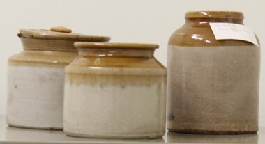
Functional object - A collection of assorted stoneware and ceramic canisters
Stoneware or pottery canisters were widely used throughout the late 19th and early 20th centuries for storing and preserving a wide range of kitchen food ingredients. Bendigo Pottery was established in 1858 and is Victoria's oldest working pottery. It was founded by George Duncan Guthrie (1828–1910) who abandoned his potter’s wheel in Scotland to join the Australian gold rush. He found a clay deposit perfectly suited for the production of ceramics, so returned to his former profession as a master potter. The population explosion created by the Australian gold rush resulted in an increased demand for all kinds of locally manufactured goods. The Bendigo Pottery became one of regional Victoria’s most important industrial enterprises. By the late 1800s the Pottery was making all kinds of household wares. One of its most popular lines was the mass produced, affordable and functional earthenware such as these canisters.These items are significant on a state and national level due to the importance of Bendigo pottery as a major Victorian manufacturer whose products were widely used in Australian homes.A group of 3 stoneware and ceramic canisters of assorted sizes. The tallest canister bears the Bendigo Pottery makers mark. The flour canister with the lid and the third canister are unmarked. Similar canister were produced by several companies in the early to mid 20th century. They were commonly used for storing flour, salt and other commodities.At bottom of largest canister "BENDIGO POTTERY" above straight linebendigo pottery, earthernware, kitchen utensils -
 Wodonga & District Historical Society Inc
Book - A Century of Racing Albury Racing Club, 1881-1981, Des Martin, 1981
The first race meeting conducted in Albury was at ‘Browns Paddock’ in 1840. From this early beginnings, the Albury Racing Club was formed on the 21st January 1881. This book details key events and personalities in the first 100 years of its history.non-fictionThe first race meeting conducted in Albury was at ‘Browns Paddock’ in 1840. From this early beginnings, the Albury Racing Club was formed on the 21st January 1881. This book details key events and personalities in the first 100 years of its history.albury racing club, racehorses. racing. new south wales, horse racing albury -
 Wodonga & District Historical Society Inc
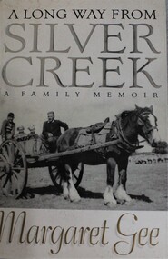
Book - A Long Way from Silver Creek: A Family Memoir, Margaret Gee, 2000
This book tells the story of Margaret Gee's family, spanning three generations living on the land in picturesque North Eastern Victoria, near Beechworth-Kelly country and steeped in the history of the gold rush and early pioneers. It is the story of her indomitable father, who grew up at Silver Creek, then joined the Australian Navy, became a prisoner of war on the Burma Railway after surviving the sinking of HMAS Perth, of his wife and family.non-fictionThis book tells the story of Margaret Gee's family, spanning three generations living on the land in picturesque North Eastern Victoria, near Beechworth-Kelly country and steeped in the history of the gold rush and early pioneers. It is the story of her indomitable father, who grew up at Silver Creek, then joined the Australian Navy, became a prisoner of war on the Burma Railway after surviving the sinking of HMAS Perth, of his wife and family.gee family, beechworth, rural families, country life -- victoria -
 Wodonga & District Historical Society Inc
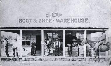
Photograph - Franz Gördes, Boot and Shoemaker, Wodonga
Franz Gördes (b.1843) who immigrated to Australia from Germany in 1871. After docking in Melbourne Franz headed for the goldfields at Spring Gully near Beechworth, but didn't strike gold. He returned to his trade and opened a boot shop in Wodonga, which burnt to the ground the day before the opening. Undeterred, he rebuilt and operated the business until his death on 8 June 1928. He was survived by his widow, Margaret as well as six sons and three daughters. Franz Gordes’ Boot & Shoe Warehouse was situated in Sydney Road, now High Street, Wodonga.This item has a well documented provenance and connection to the local history of Wodonga.A black and white photo which has also been digitised. Above shop: Cheap / Boot & Shoe Warehousebusinesses wodonga, franz gördes, geman migrants -
 Wodonga & District Historical Society Inc
Map - Tulloch & Brown's Map of the Colony of Victoria, Tulloch & Brown, 1856
The map was created by Tulloch and Brown. David Tulloch was one of the earliest engravers and lithographers in the state of Victoria. He arrived in Melbourne from Greenock, Scotland, on 3 January 1849. Following the discovery of gold Tulloch went to the Victorian goldfields in 1851, commissioned to make sketches of the diggers and the diggings for Ham’s Illustrated Australian Magazine. In November 1852 Tulloch set up in business as engraver, draughtsman, copperplate printer and lithographer. Tulloch took a map engraver, James Davie Brown, into partnership in March 1853; the several maps and specimens of commercial engraving they showed at the 1854 Melbourne Exhibition were awarded a bronze medal. That year Tulloch and Brown also received a silver medal at the Victorian Industrial Exhibition. The partnership was dissolved towards the end of 1856.This is a very early map of the Colony of Victoria including Belvoir (now know as Wodonga).A foldable map mounted on linen and with a board cover. It records the Colony of Victoria according to Surveyor's Records revised in 1857. Areas of the map are shaded to highlight different counties.At bottom right hand section of map: Tulloch & Brown's map of the Colony of Victoria : comprising part of New South Wales, the boundaries, counties, also seaport & inland townships, the gold fields with the latest discoveries, roads, tracks, &c. &c. / compiled from drawings in the Survey Office and correctly revised till 1857. Respectfully dedicated by Permission, to the Honorable Captain Andrew Clarke R.E. Surveyor General of Victoria by His Obediant Servants Tulloch & Brown, Engravers & Publishers, Melbourne". At bottom right below border : Published as the Act directs by the Proprietors, Melbourne, 1st Feb. 1856. tulloch and brown maps, rare maps victoria, victorian cartography -
 Wodonga & District Historical Society Inc
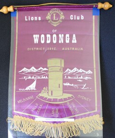
Banner - Lions Club of Wodonga
Leslie William Cole was born on 31 January 1920 in Albury, the first child of William James Cole and Gwendoline Fair. Les spent most of his childhood living with his grandparents in Bethanga, Victoria. In 1934 when he finished school, Les moved into Wodonga. His first job was at Mates Timber Yard. He later worked for Mylons of Wodonga driving taxis and buses. In 1939 after completing militia training, Les applied to enlist with the RAAF and eventually trained as an Aircraft Mechanic. He was posted to the 6th Squadron, serving in Port Moresby, Milne Bay and Goodenough Island before returning to the RAAF base in Sale, Victoria. On discharge. Les returned to Wodonga and resumed working with Mylons. After a range of jobs, Les and his wife Lorna operated a shop in Ariel Street, Wodonga. In the community, Les was a founding member of Wodonga Lions Club. He also joined the Civil Defence which was a predecessor off the SES. He became the Communications Officer and trained other members. Les became the first Controller of the Wodonga Branch of the State Emergency Service, a position he held for 17 years. The new SES headquarters was named in his honour. In retirement he also worked as a Volunteer Community Driver. Les was also named Wodonga Citizen of the Year in 1984 Les continued living in Wodonga until the age of 103 in 2023, when he moved to Melbourne to be closer to his children. He passed away on 12 December 2023. The Lions Club of Wodonga was chartered in 1965 with 18 Founding Members including Les Cole. Lions Australia was first formed in Lismore, NSW in September and has grown to be Australia’s largest service club organisation.A small purple and gold fringed banner with the emblem of Wodonga Lions ClubAt the top centre: The logo of Lions International Across the centre of banner: Lions Club of Wodonga / District 201C Australia In semi-circle below Water Tower: Melbourne/ Falls Creek/Lake Hume/ Snowy Mountains/ Sydneyles cole, wodonga lions club, lions international -
 Wodonga & District Historical Society Inc
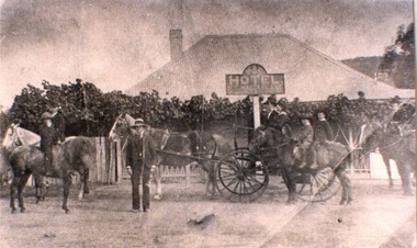
Photograph - Mac's Hotel, Wodonga, c1870s
“Mac's Hotel" in Wodonga West, one of Wodonga's earliest hotels, was owned by William Christie McFarlane who arrived in Melbourne in December 1854 from Stirling, Scotland. He spent his first three years mining for gold at Beechworth. For the next three years he was the manager of the King’s Hotel at Wooragee, which was owned by his father-in-law, Charles David King. In 1860 he bought 180 acres of land at Wodonga, eventually extending his holdings to 1,000 acres on which he farmed. He called his property “Abbey Craig” after his home in Scotland. In time he owned several properties in Wodonga, a small vineyard and 'Mac's Hotel'. Mac’s Hotel was a popular meeting place for teamsters and other travellers on the Sydney Road. It opened in the early 1860s and the license was at times in the name of W. C. McFarlane and at other times held by his wife, Mary McFarlane. William had several positions during his life in Wodonga including serving as Postmaster and conducting a Commission and Insurance Agency business. He was appointed Secretary to the first Wodonga Building Society. W. C. McFarlane also filled the position of Sheriff’s Officer, Registrar of Births and Deaths and Marriages, and Justice of the Peace. W. C. McFarlane served as a member of the Wodonga Shire Council for several years including three terms as Shire President: 1889-90, 1890-1891 and 1894-95. He passed away in Wodonga in December 1906. After his death, the license of Mac’s Hotel continued to be held by Mary McFarlane until her death in November 1910. The license was not renewed and the hotel was taken over as a residence by their son, Walter McFarlane. Unfortunately, on 25 January 1913, Walter was assisting neighbours fighting grass fires about 3 miles away when his own home was completely destroyed by fire, bringing to an end the long history of the popular hostelry, Mac’s Hotel.This image is significant because it documents an early business in Wodonga conducted by a prominent Wodonga resident.Black and white image of people standing, on horseback and in coach outside Mac' Hotel, West Wodongamac's hotel, hotels wodonga -
 Wodonga & District Historical Society Inc
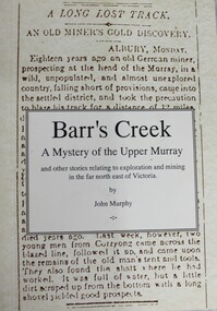
Book - Barr's Creek - A Mystery of the Upper Murray, John Murphy, 1998
A collection of stories relating to exploration and mining in the far North East of Victoria.non-fictionA collection of stories relating to exploration and mining in the far North East of Victoria.gold mining, upper murray region, upper murray victoria, upper murray nsw -
 Wodonga & District Historical Society Inc
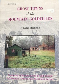
Book - Secrets of Ghost Towns of the Mountain Goldfields, Luke Steenhuis, 1999
Stories from 50 former towns in and around Melbourne's North-east mountain region. These old towns include: Aberfeldy, Aberfeldy Crossing, BB Township, Blue Jacket, Clarke's Flat, Concord Gully, Edwards Reef, Fultons Creek, Jericho, Loch Fyne, Red Jacket, Store Point, The Springs, Toombon, Toombon Upper, Tullamore, Upper Thomson, Victors Quartz, Violet Town & White Star.non-fictionStories from 50 former towns in and around Melbourne's North-east mountain region. These old towns include: Aberfeldy, Aberfeldy Crossing, BB Township, Blue Jacket, Clarke's Flat, Concord Gully, Edwards Reef, Fultons Creek, Jericho, Loch Fyne, Red Jacket, Store Point, The Springs, Toombon, Toombon Upper, Tullamore, Upper Thomson, Victors Quartz, Violet Town & White Star.ghost towns victoria, gold mining victoria -
 Wodonga & District Historical Society Inc
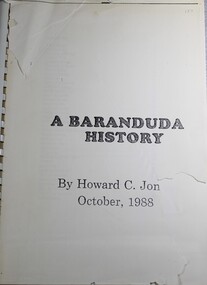
Book - A Baranduda History, Howard C Jones, 1988
A history of Baranduda in Northeast Victoria. Baranduda is a rural area and, since the 1970s, a rural and residential locality formed under the authority of the Albury Wodonga Development Corporation. It is near the junction of Yackandandah Road and the Kiewa Valley Highway, 10 km south-east of Wodonga. This publication traces the history of the area from its earliest know indigenous inhabitants, through the days of the earlier establishment of pastoral runs to more recent developments.Spiral boundnon-fictionA history of Baranduda in Northeast Victoria. Baranduda is a rural area and, since the 1970s, a rural and residential locality formed under the authority of the Albury Wodonga Development Corporation. It is near the junction of Yackandandah Road and the Kiewa Valley Highway, 10 km south-east of Wodonga. This publication traces the history of the area from its earliest know indigenous inhabitants, through the days of the earlier establishment of pastoral runs to more recent developments.baranduda, pioneers victoria, huon family, wodonga pioneers -
 Victorian Harness Racing Heritage Collection at Lord's Raceway Bendigo
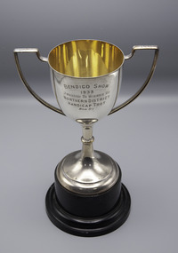
Memorabilia - Gold, Silver trophy, 1933 Bendigo Show, Northern District Handicap Trot
... District Handicap Trot Memorabilia Gold, Silver trophy ...1933 Bendigo Show Northern District Handicap TrotTwo Handled Cup Shaped Trophy on a Wooden BaseBendigo Show / 1933 / Awarded to Winner of / Northern District Handicap Trot / Won bytrophy, harness horse, 1933, bendigo show -
 Warrnambool and District Historical Society Inc.
Book - La Trobe Journal and Art Works Vol 1 & Vol 2, 1999
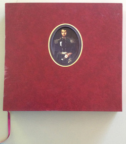
These volumes reproduce the diary material and the landscapes and sketches of Charles La Trobe, the Superintendent of the Port Phillip District of New South Wales ( 1839- 1851) and Lieutenant Governor of the colony of Victoria ( 1851-54 ). La Trobe is regarded as the man most responsible for the establishment of Warrnambool in 1847. His diaries document his trips to the Warrnambool region in 1845, 1846, 1848 and 1849 before and after the town site was settled.These volumes are of artistic significance being beautifully and expensively produced. The volumes contain information of vital importance to our knowledge of our early Warrnambool history. Other important details in the diary include information on early shipwrecks and the first settlers in our district in our district, especially the Allan brothers..1 This is a burgundy leather bound book of 380 pages. It has gold lettering on the cover and the spine and an oval inset in the centre of the front cover containing a coloured portrait of Charles La Trobe. The pages contain black and white and coloured art works and sketches and printed material. There is a burgundy coloured ribbon for marking pages The book is encased in a hard leather cover with a cut out window with gold edging. .2 This is a burgundy leather bound book of 343 pages. It has gold lettering on the cover and the spine and a rectangular inset in the centre of the front cover containing a coloured sketch of a rock, sea and cliffs drawn by Charles La Trobe. The pages contain sepia and black and white drawings and printed material. There is a burgundy coloured ribbon for marking pages. The book is encased in a hard leather cover with a cut out window with gold edging . .1 Charles Joseph La Trobe AUSTRALIAN NOTES 1839-1854 .2 Charles Joseph La Trobe LANDSCAPES AND SKETCHES charles la trobe, early warrnambool, la trobe journals -
 Bacchus Marsh & District Historical Society
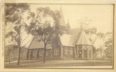
Photograph, Holy Trinity Church Bacchus Marsh 1883
The Holy Trinity Anglican Church in this location was first opened in 1877. An earlier nearby prefabricated Church building known as the 'Iron Church' had served as the Anglican place of worship in Bacchus Marsh from around 1855 until 1877. The 1877 sandstone Church with a slate roof was intended as a permanent structure for Anglican worship in Bacchus Marsh and still stands in 2024 and continues to function as an Anglican Church. The building was designed by Frederick Wyatt and is described as early English Gothic in style. It was opened on 5 June 1877 by Bishop Moorhouse of Melbourne. The sandstone was acquired from Grant's quarry at Maddingley.Small sepia unframed photograph on card with gold border framing photograph. Housed in the Jeremeas Family Album, which contains photographs of Bacchus Marsh and District in 1883 by Stevenson and McNicoll. The photograph depicts the recently constructed Anglican Holy Trinity Church in Gisborne Road, Bacchus Marsh. The view of the building is from Gisborne Road looking west. From this angle the rear and southern side of the building can be seen. A picket fence along the entrance to the Church grounds can be seen in the foreground.On the front: Stevenson & McNicoll. Photo. 108 Elizabeth St. Melbourne. COPIES CAN BE OBTAINED AT ANY TIME. On the back: LIGHT & TRUTH inscribed on a banner surmounted by a representation of the rising sun. Copies of this Portrait can be had at any time by sending the Name and Post Office Money Order or Stamps for the amount of order to STEVENSON & McNICOLL LATE BENSON & STEVENSON, Photographers. 108 Elizabeth Street, MELBOURNE churches bacchus marsh, holy trinity anglican church bacchus marsh, holy trinity church of england bacchus marsh, stevenson and mcnicoll 1883 photographs of bacchus marsh and district -
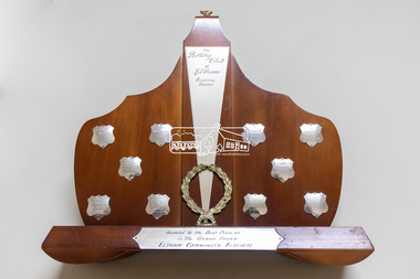 Eltham District Historical Society Inc
Award - Trophy, The Rotary Club of Eltham Perpetual Trophy, Awarded to the Best Display in the Grand Parade, Eltham Community Festival, 1979-1986
1986 Grand Parade, 8 November. The Society's entry in the Eltham Community Festival parade included Ben Hall's Cobb and Co. coach and was awarded the major prize for the parade. This involves a perpetual trophy which the Society holds for one year. Individual shields attached to trophy inscribed with annual Grand Parade winners: 1979 - Cubs of the Eltham District 1980 - Montmorency South Primary School 1981 - Co Winner, Eltham Primary School Dalton Street 1981 - Co Winner, Our Lady Help of Christians 1982 - Cubs of the Eltham District 1983 - Research Primary School 1984 - Montmorency South Primary School 1985 - Montmorency Garden Club 1986 - Shire of Eltham Historical Society and one blank shield It appears the trophy was replaced in 1987 with a Best Display award which again was won by the Society, and again in 1988 Polished wooden trophy with gold plastic wreath, inscribed metal plaques and ten inscribed metal shields. Gold plastic ornament sitting on top (broken off)The Rotary Club of Eltham Perpetual Trophy Awarded to the Best Display In the Grand Parade Eltham Community Festivalaward, eltham community festival, eltham festival, trophy, shire of eltham historical society, eltham district historical society, victorian folk music club, rotary club of eltham, perpetual trophy, 1986, grand parade, 1979, 1980, 1981, 1982, 1983, 1984, 1985, cubs of the eltham district, eltham primary school, montmorency garden club, montmorency south primary school, our lady help of christians primary school, research primary school