Showing 486 items
matching kilometres
-
 Orbost & District Historical Society
black and white photograph/ poscards, Vogt. W.S, C1890 - 1920
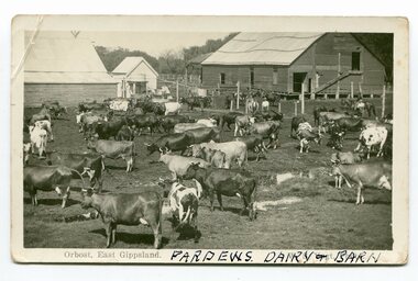
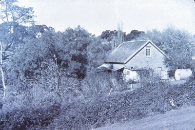
Edward James Pardew died in 26/9/1927 aged 92. He came to Orbost from New Zealand in 1886 and selected 720 acres of hill land in the Brodribb area. He was a member of the first Orbost Shire Council. His daughter had a fruit & meat shop in McLeod Street. He was an inaugural vestryman of St James Church of England. One of the most prominent farmers on the Snowy was John Gilbert, a large landowner. His breeding establishment was at Tullagoota, about two and a half kilometres down the river from Orbost.Dairying in the Orbost district was once a mainstay of the farming community. Today the properties are fewer and smaller.Two black / white photographs of dairy herds. 3188.1 - on front - printed -"ORBOST EAST GIPPSLAND"; hand-written - :PARDEWS DAIRY & BARN" 3188.2 - on front - printed - " W. S. VOGT"; hand-written - "DAIRY HERD TALLAGOOTA< ORBOST"dairying-orbost agriculture-orbost pardew-dairy tallagoota-dairy -
 Federation University Historical Collection
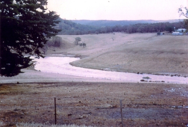
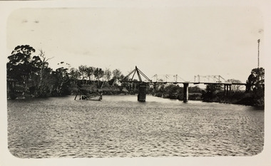
Photograph - Colour, Leigh River near Garibaldi Bridge
The Leigh River is a major tributary and catchment of the Barwon River. Fed by the Yarrowee River that rises near Ballarat, the Yarrowee reaches its confluence to form the Leigh in the vicinity of Cambrian Hill and Golden Plains Shire. The Leigh River rises below Mount Mercer and flows generally south, joined by three minor tributaries before reaching its confluence with the Barwon River, southeast of the central business district of Inverleigh. The river descends 265 metres (869 ft) over its 61-kilometre (38 mi) course. (https://en.wikipedia.org/wiki/Leigh_River_(Victoria)Relates to historical information about flooding of the Leigh River in 1933. Relevant to the history of Garibaldi and Durham Lead.A number of colour photographs showing the Leigh River between Garibaldi and Durham Lead, Victoria, .1 - .3) photographs of the Leigh River in flood .4 - .18) general photos of the Leigh River and surrounding countryside .19) broad angle photograph of the Leigh River and surrounding countryside leigh river, garibaldi, garibaldi bridge, durham lead, vincent family -
 Nillumbik Shire Council
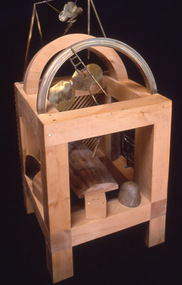
Sculpture: Anthony PRYOR (b.1951- d.1991 Melb, AUS), Paretaio, 1985
In the early 1970s, Arthur Boyd bought and restored a large, two-storey traditional farmhouse called Il Paretaio. Situated on the crest of a hill and surrounded by fields and olive groves, it is five kilometres from the village of Palaia in the province of Pisa, Tuscany. Boyd established this farmhouse as a residency programme, (which was later managed by the Australia Council). The residency program ended in 1990. Anthony Pryor undertook an Australia Council residency at Paretaio in 1984. This work is one in a series made during his time there. This work was entered into the Shire of Eltham Art Award in 1985.Pryor is an artist of national significance. This work is an example of his series of 'boxes' made principally for his own pleasure and often swapped with artists and other friends as soon as they were finished. The 'box' series was part inspired by Japanese techniques of wooden construction. Pryor first visited Japan in 1975 and was immediately drawn to Japanese methods of working with stone and wood. Many of these boxes are based upon the principles of the Japanese Zen Buddhist monk Sengai Gibon (1750-1838). This work relates to Sengai's famous hanging scroll Circle, Triangle and Square in which the circle can be read to stand for the cosmos, the square for the individual, and the triangle for aspiration. A heavy, box-like (cube) structure created from huon pine, with bronze, brass and stone elements. Within the cube is an eastern inspired, rear lattice wall in combination with bronze domestic fittings, and symbols (cube, pyramid and circle). Metal lightning, clouds and wooden rainbow hover over an asymmetrical bronze bed floating within the cube. A chair leans and a tilting ladder reaches towards the sky. Stamped into wood: lower right 'ANTHONY PRYOR PARETAIO'huon pine, pryor, brass, bronze, stone, cube, paretaio, italy, eastern, japan, sengai gibon, symbols, zen buddhism, sculpture, personal -
 City of Greater Bendigo - Civic Collection
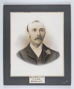
Photograph - Portrait of Councillor Orr, The Yeoman Studios, Ex. Councillor / F. Orr / Eppalock
The district of Strathfieldsaye was proclaimed in 1861 and named a Shire on the 17th September in 1866. It remained a shire until amalgamation in 1994 when it became part of the City of Greater Bendigo. The shire was located 8 km to the south- east of Bendigo and covered an area of 601 square kilometres and extended from the Calder Highway to the Coliban and Campaspe Rivers. The shire's administration centre was in Strathfieldsaye until 1972 when new offices were opened in Kennington. Eppalock Ward is one of three wards in the Greater Bendigo municipality which includes the former Strathfieldsaye Shire. Framed black and white head and shoulder portrait with hand coloured detail. Man with profile slightly to right, walrus moustache, image encircled. Photograph is attached to mount card. Hand written title lower centre.Ex. Councillor / F. Orr / Eppalock / The / Yeoman / Studiosshire of strathfieldsaye, councillor orr -
 Melbourne Tram Museum
Document, Victorian Parliament, "The Plenty Road, Preston, Tramway Extension Inquiry", 1967
Report by the Victorian Parliamentary Public Works Committee on "The Plenty Road, Preston, Tramway Extension Inquiry" - 1967. The inquiry examined the MMTB's proposal to extend the East Preston line 0.7miles or 1.3km. The Committee took evidence from the MMTB, bus operators, the Victorian Railways, residents, La Trobe University, Preston City Council and others. The Committee recommended against the proposal. The report lists those members of Parliament involved. The line was subsequently extended by 1.2 kilometres from Tyler Street to Boldrewood Parade during 1983 and subsequently to Bundoora. Demonstrates the method of holding parliamentary inquiries into new tram lines.Document - report - 9 pages stapled in top left-hand corner, printed with a spirit duplicator.tramways, parliament, new lines, east preston, inquiries, bundoora, plenty road -
 Dandenong/Cranbourne RSL Sub Branch
Print - Framed military print, Take Off
Doolittle Raid occurred on the 18th April 1942 during WW 2.. The raid was the first air raid by the US Forces on Tokyo and Honshu and the Japanese Archipelago. A special unit of USAAF B25 Mitchell Bombers trained under the command of Col. James Doolittle flew from the carrier USS Hornet. B25 Mitchell Bomber had 2 Radial engines developing 1700 hp. Wingspan of 20.6 metres. Length 16.3 metres. It carried a crew of 4 to 6 personnel and had a range of 2175 kilometres and a bomb payload of 1360 Kgs.Important event of war against Japanese.57 cm x 38.5 cm. Ebonised and Gold frame. Showing B 25 Mitchell bomber taking of from USS Carrier Hornet.Inscribed " Take Off " Doolittle Raid on Tokyo 1942. -
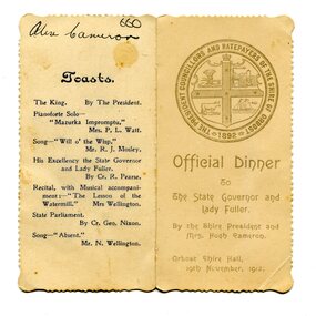 Orbost & District Historical Society
menu, 1912
This item is an invitation to a dinner given by the Shire President and Mrs Hugh Cameron for the State Governor and Lady Fuller to be held in the Orbost Shire Hall on November 19, 1912. The governor and his wife left Melbourne on November 14 on a visit to East Gippsland. Hugh Cameron (1850-1921) was on the Orbost Shire council from 1892-1915. (more info. in O.D.H.S. newsletter -Tambo Shire) The Shire of Orbost was a local government area about 380 kilometres east of Melbourne, the state capital of Victoria, Australia. The shire covered an area of 9,347 square kilometres (3,608.9 sq mi), and existed from 1892 until 1994. Originally, Orbost was part of the Bairnsdale Road District which was created on 30 April 1867. Splitting away as part of the Shire of Tambo in 1882, Orbost was first incorporated as a shire in its own right as the Shire of Croajingolong on 30 May 1892. It received its present name on 17 February 1893. On 3 January 1913 part of its western riding was annexed to Tambo as its Cunninghame Riding. On 2 December 1994, the Shire was abolished, and merged with City and Shire of Bairnsdale, Shire of Tambo, most of Shire of Omeo and the Boole Boole Peninsula from Shire of Rosedale into the Shire of East Gippsland. This item is associated with Orbost Shire Council which no longer exists. It is also associated with Hugh Cameron.A small menu on a cream folded card with blue print. On the front is stamped a large blue logo of the Shire of Orbost. The text is "Official Dinner". On the back is a list of toasts and inside is the menu.On back - handwritten - "Alex Cameron"orbost-shire-council cameron-hugh -
 Kew Historical Society Inc
Photograph - Bridge over the Tambo River, 1926
Henry Beater Christian (1886-1962) , was a descendant of one of the earliest settler families in Kew. Employed at the Kew Asylum as a 'public servant', he was a skilled amateur photographer, photographing numerous scenes in Kew and on his travels around Victoria. The majority of his photographs date from 1916 to 1929. His finest photographs are housed in two photograph albums. Digital copy of a photograph from page 31 of the 47-page photograph album containing 261 gelatinous silver images, loaned by Diane Washfold with permission given to digitise and hold a copy in our collection. John Chapman has written in 'Bushwalking Clubs - A Brief History', about the establishment in Victoria of the first bushwalking club in 1888, and the popularisation of bushwalking during the interwar period. Henry Christian's 'walks' appear to have been undertaken solely or with a companion/s. This black and white photo is part of a group of six photos taken on an 18 kilometre walking trip between Bruthen and Swan Reach in East Gippsland in 1926. The route of the walk followed the Tambo River. The photographer has focussed the view on a ruined bridge, presumably caused by a flood, crossing the river. Sections of the left hand pier and span can be seen in the river."BRUTHEN TO SWAN REACH 1926"henry beater christian (1886-1962), landscape photography, christian-washfold collection, photograph albums, bushwalking, bruthen, swan reach, tambo river, east gippsland -
 The Beechworth Burke Museum
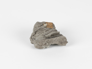
Geological specimen - Fossiliferous Mudstone, Unknown
This specimen was found in Cape Patterson, Vic. Cape Paterson is a cape and seaside village located near the town of Wonthaggi, 132 kilometres southeast of Melbourne, in the Bass Coast Shire of Gippsland, Victoria, Australia. These dark, fossiliferous Mudstones were deposited in slow-moving water associated with sedimentary basins & continental shelves. They are rich in carbon which makes them almost black. This is typical of an anoxic, reducing environment such as deep water or stagnant conditions where carbon-rich material would remain unoxidised during subsequent deposition & diagenesis. it has an imprint of a leaf in the rock itself, displaying the fossil of the plant. This specimen is unique due to the leaf impression within the stone itself. Imprint fossils are formed from an organism moving in some way, leaving behind a trace or track. These tracks are preserved when the clay/silt dries slowly and is covered by other sediment. Plants can also leave imprint fossils when they are covered by sediment. The leaf tissue degrades, leaving an imprint of where the leaf once was. This specimen is part of a larger collection of geological and mineral specimens collected from around Australia (and some parts of the world) and donated to the Burke Museum between 1868-1880. A large percentage of these specimens were collected in Victoria as part of the Geological Survey of Victoria that begun in 1852 (in response to the Gold Rush) to study and map the geology of Victoria. Collecting geological specimens was an important part of mapping and understanding the scientific makeup of the earth. Many of these specimens were sent to research and collecting organisations across Australia, including the Burke Museum, to educate and encourage further study.These dark, fossiliferous Mudstones were deposited in slow moving water associated with sedimentary basins & continental shelves. They are rich in carbon which makes them almost black. This is typical of an anoxic, reducing environment such as deep water or stagnant conditions where carbon rich material would remain unoxidised during subsequent deposition & diagenesis. FOSSILIFEROUS MUDSTONE / Locality: Cape Patterson, Victoria | Descriptive catalogue / Pg 27 No 95 / "Grey Clay, / Cape Paterson with leaf impressions' / 15/4/21 C. William /mudstone, cape patterson, leaf imprint, fossilised leaf, fossiliferous mudstone -
 Warrnambool and District Historical Society Inc.
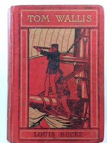
Book, Tom Wallis Louis Becke, Early 20th century
This book, ‘Tom Wallis’ written by Louis Becke was awarded as a third prize to Bertie Wilson by the Grasmere Presbyterian Sabbath School in 1910. Grasmere is a small settlement about 12 kilometres from Warrnambool and was settled in the 1840s by pastoralists prior to the founding of Warrnambool. The Grasmere Presbyterian Church and Sunday School were established in 1898 though services had been held prior to this date in an older church which was converted at that time to house the Sunday School. The Sunday School was burnt down in 1914 and later rebuilt. Mr Paton, the Sunday School teacher in 1910, was on the Board of Management of the church in 1911. This book is significant because it is a memento of the Grasmere Presbyterian Sabbath School of 1910. Sunday School attendance was a strong feature of the religious, educational and social life of many children in the 19th century and the first half of the 20th century. Sunday Schools still operate but have fewer children attending in relation to the numbers of Protestant churches adherents. This is a hard cover book of 320 pages plus several pages at the end detailing other books published by the Religious Tract Society. The cover is dark red with an illustration in black, red and grey colours of two sailors aboard a ship. The book was a prize given to Bertie Wilson from the Grasmere Presbyterian Sabbath School in 1910. There are several illustrations (black and white plates) inserted throughout the book. The inscription plate has both printed and handwritten material. The colours on the cover, particularly on the spine, are somewhat faded. Front Cover: ‘Tom Wallis, Louis Becke’. Inscription Plate: ‘Grasmere Presbyterian Sabbath School, Third Prize, Awarded to Bertie Wilson, Mr Paton Teacher, Xmas, 1910’bertie wilson, grasmere presbyterian sunday school, warrnambool -
 Warrnambool and District Historical Society Inc.
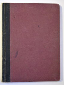
Book - Hospital Auxiliary Minute Book, Secretary of Allans Forest Red Cross Hospital Auxiliary, 1925-1930
This book contains the Minutes and financial details from the Allans Forest Red Cross Hospital Auxiliary from 1925 to 1930. Allans Forest is a small locality on the Great Ocean Road about three kilometres from the township of Allansford on the eastern fringe of Warrnambool. The Hospital Auxiliary was formed as an extension of the Allansford group in 1925 to provide support for the Warrnambool and District Hospital. The group raised funds with dances and jumble sales and donated to the hospital such items as groceries (especially home made jams and soaps), hospital linen and baby wear. The hospital would provide tins of fat for the ladies to make the soap. This exercise book is of interest as a memento of the activities of a small group in a small settlement in the Warrnambool area nearly a hundred years ago. It shows the reliance in the past of a town hospital on local groups to provide basic items such as food and linen.This is an exercise book with a dark red cardboard cover and black binding on the spine. The pages have ruled black lines and handwritten entries in ink. Some pages are blank.Allan's Forest Red Cross Hospital Auxiliaryallans forest, warrnambool and district hospital, allans forest red cross -
 Greensborough Historical Society
Photograph - Digital Image, Willis Vale, 1950c
House built by Edward Maygar, Robert Whatmough lived there mid 19th century and later sold to Partington family. It was located on the Plenty River at Partington's Flat Greensborough. The derelict Willis Vale house was vandalized later destroyed in 1964 when a fire originating from North Plenty Gorge - Kurrak Road - was lit by two teenage boys and made its way several kilometres down to Partington's Flat Greensborough. This photo was taken after the Partington's moved house in 1947 across the river where Alan built their new Alwyn house that had access to electricity.A pioneer home in Greensborough.Digital copy of black and white photograph.willis vale, partington family, robert whatmough, maygar family -
 Orbost & District Historical Society
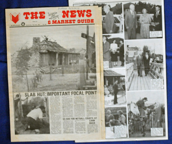
newspaper clippings, April, May 1987
The Slab Hut (Orbost Visitor Information Centre) was opened on March 28, 1987. It was officially opened by Dr D. Caughey, the governor of Victoria. The Orbost Visitor Information Centre is situated in Forest Park on Nicholson Street. The centre is housed in the historic Slab Hut. The hut was an original family dwelling built in 1872, on a site approximately three kilometres upstream from the junction of the Buchan and Snowy Rivers. The Hut was removed from its original site around 1970, and stored until 1984 when the Shire Council approved the current site. It was restored and brought to life as a Tourist Information Centre in 1987.The Slab Hut is an icon of Orbost. These newspaper articles are contemporary records of the opening of this building.A selection of articles from The News and the Snowy River Mail. All relate to the opening of the Slab Hut, the Orbost Visitor Information Centre. They are photographs, information and the history of the Slab Hut.slab-hut-orbost newspaper-snowy-river-mail -
 Orbost & District Historical Society
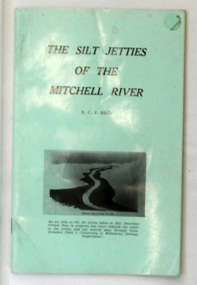
book, James Yeates & Sons (Printing) Pty Ltd, The Silk Jetties of the Mitchell river, 1972
This booklet was the first of a series of scientific and historical studies of Gippsland to be published by the Bairnsdale Advertiser. The author, Eric Charles Frederick Bird was Principal Fellow, Department of Geography, University of Melbourne, Australia. The Mitchell River silt jetties are an unusually long, thin landform located in the Gippsland Lakes region. They have been formed over millions of years by sediment deposition from the Mitchell River during periods of low water flow and subsequent wash-through during periods of high water flow. The long narrow banks of silt extend more than eight kilometres east into Lake King. This item is a useful reference for the silt jetties of the Mitchell River.A 32 pp book with alight green cover. The title is in black print, " The Silk Jetties of the Mitchell River" and underneath the title there is a b/w photograph of the Mitchell River and silt jetties taken from above in 1931. It was written by E. C. F. Bird.silt-jetties mitchell-river paynesville bird-e.c.f. -
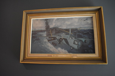
 Australian Gliding Museum
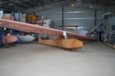
Machine - Glider – Sailplane, 1930s
This Dunstable Kestrel glider, which came to be known as the "Red Kestrel" on account of its colour scheme, was built from plans by Percy Pratt between 1936 and 1938. It was first flown in 1938. Thereafter, it was flown regularly by Pratt at Geelong, Victoria. At the national rally organized by the Australian Gliding Association in December 1939 – January 1940 at the Belmont Common, Geelong, Victoria, Pratt, in his Kestrel, recorded an exceptional 13 kilometre cross country flight of one hour 43 minutes reaching a height of approximately 5500 metres [Allan Ash, Gliding in Australia, p 86]. This Dunstable Kestrel glider represents a good example of a 1930s era sailplane. It is one of three of the type that currently exist in Australia. The aircraft is also important for Australian gliding history because it was built, owned and flown by gliding pioneer Percy Pratt.Wooden airframe covered with plywood and fabric. In course of restoration.australian gliding, glider, sailplane, dunstable, kestrel, bill manuel, percy pratt, belmont, geelong -
 City of Greater Bendigo - Civic Collection
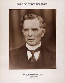
Photograph - Portrait of Shire Secretary Brennan, Unknown
The district of Strathfieldsaye was proclaimed in 1861 and named a Shire on the 17th September in 1866. It remained a shire until amalgamation in 1994 when it became part of the City of Greater Bendigo. The Shire was located 8 km to the south- east of Bendigo and covered an area of 601 square kilometres and extended from the Calder Highway to the Coliban and Campaspe Rivers. The shire's administration centre was in Strathfieldsaye until 1972 when new offices were opened in Kennington. Secretary Brennan, son of Councillor M. Brennan was appointed after his fathers death to the role and according to the The Bendigo Independent was in the role in 1917. See References.Framed black and white head and shoulder portrait of Councillor Brennan. Profile slightly to left. Cut rectangle cream mount. Hand written title top and lower centre. Shire of Strathfieldsaye / R. B. Brennan, Esq / Secretarystrathfieldsaye shire council, secretary strathfieldsaye shire -
 Warrnambool and District Historical Society Inc.
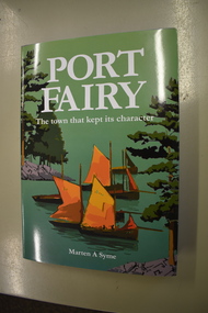
Book, Port Fairy – The Town That Kept Its Character, 2018
This book by Marten Syme is a history of Port Fairy from 1835 to 2018. The earlier histories of Port Fairy do not cover most of the 20th century and none of the 21st century. This book is a scholarly work and offers fresh perspectives on many aspects of Port Fairy history and questions some long-held views, especially on the early years of the town. Port Fairy, 293 kilometres west of Melbourne, has a rich history and is one of the earliest places in Victoria to be settled by Europeans. The author Marten Syme has written extensively on both maritime and local history and is a resident of Port Fairy. This book is of considerable significance as it is a comprehensive history of Port Fairy and complements and adds to the earlier histories of this town. It will be a very useful addition to libraries and will be a great aid to family history and local history researchers.This is a hard cover book of 295 pages. The cover is grey with gold lettering on the spine. The dust cover has white printing and an illustration with a green background with a multi-colour design of sailing ships, trees and harbour entrance. The pages of printed material are in five parts with a bibliography and an index. The book has black and white photographs, maps and other illustrative material. Signature of author (Marten A. Syme)port fairy, marten syme, port fairy -
 Sunbury Family History and Heritage Society Inc.
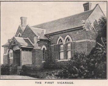
Photograph, 'Priorswood' Vicarage
The grand home is the first Church of England vicarage, 'Priorswood' to be built in Sunbury. It was sited at the east end of Station Street on Vicarage Hill and about a kilometre from St. Mary's Church in O'Shanassy Street. The distance between the two buildings presented a problem especially when the vicar had to negotiate a natural waterway across the lower end of Station Street after heavy rain. In 1914 a new Federation style vicarage was built adjacent to the church in O'Shanassy Street and was replaced in the 1960s with a more modern building, which was demolished in the 2020s to make way for 8 Oaks Community Centre.'Priorswood' is now a private home and has a local heritage listing.A print of a non-digital black and white photograph of a Gothic style brick home with a slate roof.'priorswood' vicarage, st. mary's church of england., sunbury, vicarages -
 Orbost & District Historical Society
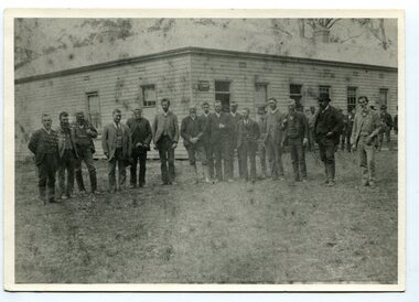
black and white photograph, late 19th century - early 20th century
Probably taken 1890's before Orbost was separated from Tambo. The Shire of Tambo was a local government area about 320 kilometres east of Melbourne. The shire covered an area of 3,506.86 square kilometres and existed from 1882 until 1994. Tambo was first incorporated as a shire on 6 January 1882, splitting away from the Shire of Bairnsdale. On 30 May 1892 it lost three-quarters of its land area when the Shire of Orbost was incorporated. A small amount was re-annexed as Cunninghame Riding on 3 January 1913. On 2 December 1994, the Shire was abolished, and merged with the City and Shire of Bairnsdale, Shire of Orbost, most of the Shire of Omeo and the Boole Boole Peninsula from Shire of Rosedale into the Shire of East Gippsland. ( more information Newsletter July 2010). This photograph is of Tambo Shire Council meeting at Faithful's Hotel, Nowa Nowa. It includes Snowy River Riding councillors. Mary Stirling, wife of Shire Secretary Thomas Telfer Stirling, took over the Nowa Nowa Hotel from Moses Faithful in 1895. Photograph includes: John Butter BESLEY, John William BORLAND, Charles Begg IRVINE, William J. LAMBOURN, James LARKIN, Ronald McDOUGALL, Donald McRAE, William ROADKNIGHT jnr., David WILLIAMS, James CAMERON, Charles Henry GROVE. (info. John Phillips) This item is associated with the Tambo Shire Council, a local government which no longer exists.A black / white photograph of a group of men standing in a line outside a large timber building.on back - "Tambo Shire Council . Meeting at Nowa Nowa - Stirling's Hotel"tambo-shire-council faithful's-hotel-nowa-nowa local-government -
 Bendigo Military Museum
Photograph - PHOTOGRAPHS, GRINTON COLLECTION, FRAMED, 2008 - 2009
Frame 8. Photo 1. Medals and Awards presentation. Believed to be at Allonville, some 4 kilometres from Amiens in May 1918. General Birdwood presented medals to the 38th Batt who were resting at Allonville for 2 weeks. Photo 2. The "Rising Sun Badge" believed to be the one on Salisbury Plain in England. Photo 3. On leave somewhere, 4 smart looking young men. Photo 4. Jack Grinton on leave in England. Within the collection there are a lot of both Jack and Bert with this family group. Refer Cat No. 5880P for Exhibition details. Refer Cat No. 1280 for Jack GRINTON Service records.Photographs - black and white on paper. 4 photographs - top to bottom. 1. Award presentation with troops. 2. "Rising Sun Badge" in a landscape scene. 3. 4 soldiers in front of a building. 4. Family group. Frame - timber with black colour paint. Glass front. Mount - black colour cardboard. Backing cardboard - handwritten notation.Backing cardboard - handwritten blue felt tip pen "8."framed photographs, grinton collection, ww1, 38th -
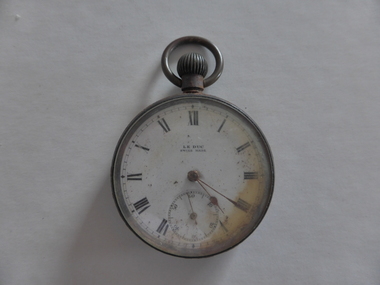 Warrnambool and District Historical Society Inc.
Watch, Watch from Nestor
This watch belonged to Norman Borthwick of Ecklin, who, with his wife and two children, Janet, aged 7 and Jack, aged 6, were survivors of the sinking of the cruise boat, Nestor, on the Hopkins River in January 1921. The boat was on its regular trip from the Hopkins River boatsheds to Jubilee Park with 80 passengers. Ten people were drowned when the boat began to take water and sank about a kilometre upstream. Norman Borthwick was wearing the watch at the time and the hands have stopped at 5.20 p.m. on the day of the tragedy. A hero of the day was Constable Sharrock who drowned after saving the lives of several of those on boardThis watch is of great significance as it is an item that belonged to Norman Borthwick who was wearing the watch when he survived the sinking of the Nestor in the Hopkins River in 1921. This was one of the great tragic incidents in Warrnambool in the early 20th centuryThis is a Swiss-made watch made of gunmetal with a glass face and a metal winder at the top and a ring to attach the watch to a chain. The figures are Roman numerals and there is a separate minute hand dial. The watch is much rusted and is not able to be easily opened to see the mechanism. The gold-coloured hands point to the time of 20 past 5. The face of the watch is discoloured on the right hand side.‘Le Duc, Swiss made’nestor sinking, norman borthwick, constable sharrock -
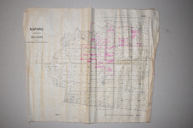 Warrnambool and District Historical Society Inc.
Maps (2), 1 Kapong .2 Hawkesdale, 1 1913 .2 1942
These two maps of the Kapong/ Hawkesdale area in Victoria show the original lands that belonged to the pioneer settler, Charles Hamilton MacKnight and the handwritten annotations that show the subsequent owners of these lands. Charles Hamilton Macknight (1819-1873) came to Australia from Scotland in 1841 and in 1842, with partners, James Irvine and William Campbell, established the property of Dunmore in Broadwater (24 kilometres from Hawkesdale). He was a prominent breeder of sheep, cattle and horses. Sections of his lands were acquired by the Baulch family and these maps were acquired from a member of the Baulch family, with Stanley Baulch being the possible annotator of the Kapong map. These maps are of interest as they show the properties that belonged to the pioneer settler, Charles Hamilton MacKnight and the subsequent division of these lands, some of these passing into the hands of the Baulch family. As the Kapong map also shows other original landowners, it will be a useful tool for researchers..1 This is a map of Kapong in the County of Villiers. It is on a rectangular-shaped piece of linen-backed paper with black printing and some handwritten annotations in red ink. It is crumpled at the edges. .2 This is a rectangular-shaped piece of paper showing a map of the Hawkesdale area. The printed material is in grid form in black, green and red. At the left bottom edge it has a mauve stamp. kapong, victoria, hawkesdale, victoria, dunmore estate, victoria, charles hamilton macknight, baulch family, western victoria, history of warrnambool -
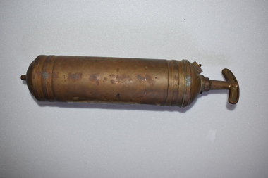 Warrnambool and District Historical Society Inc.
Fire Extinguisher, Pyrene Co Ltd, Mid 20th century
This fire extinguisher was used for commercial purposes in the Nullawarre Post office. The item was made in England by the Pyrene Co Ltd (1914-1971), one of the world’s leading manufacturers of fire fighting equipment in the early to mid 20th century. The extinguisher had a pump action and probably contained carbon tetrachloride. Nullawarre is a small agricultural settlement 25 kilometres south east of Warrnambool. The Nullawarre area was settled in the late 1860s and 1870s and today has a store and Post Office and a school. Charles Williams was the Post Master at Nullawarre in the early to mid 20th century and also delivered the mail. His wife, Vida was the Post Mistress. This fire extinguisher is of interest firstly as an example of a common item used commercially in the past and secondly as an item that came from the Nullawarre Post Office, used in this commercial building in the early to mid 20th century. This is a metal fire extinguisher which has been painted but the paint is mostly worn away. It is cylindrical in shape with ridged areas at the base and top. It has a clip handle. The cylinder is empty.‘Pyrene’vintage fire extinguishers, nullawarre post office, warrnambool -
 Greensborough Historical Society
Photograph - Digital Image, Willis Vale, 1950c
Willis Vale: House built by Edward Maygar, Robert Whatmough lived there mid 19th century and later sold to Partington family. It was located on the Plenty River at Partington's Flat Greensborough. Land use included farming and orchards. The derelict Willis Vale house was vandalized in 1964 and destroyed when a fire originating from North Plenty Gorge - Kurrak Road - was lit by two teenage boys and made its way several kilometres down to Partington's Flat Greensborough. This photo was taken after the Partington's moved house in 1947 across the river where Alan built their new Alwyn house that had access to electricity.Home of the Partington familyDigital copy of black and white photograph.willis vale, partington family, whatmough, maygar family -
 Greensborough Historical Society
Photograph - Digital Image, Willis Vale, 1950c
Willis Vale: House built by Edward Maygar, Robert Whatmough lived there mid 19th century and later sold to Partington family. It was located on the Plenty River at Partington's Flat Greensborough. Land use included farming and orchards. The derelict Willis Vale house was vandalized in 1964 and destroyed when a fire originating from North Plenty Gorge - Kurrak Road - was lit by two teenage boys and made its way several kilometres down to Partington's Flat Greensborough. This photo was taken after the Partington's moved house in 1947; across the river where Alan built their new Alwyn house that had access to electricity.Home of the Partington familyDigital copy of black and white photograph.willis vale, partington, whatmough, maygar -
 National Wool Museum
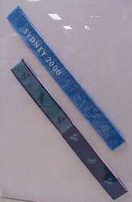
Medal ribbon, Sydney 2000 Paralympic Games medal ribbon
Medal ribbon used for Olympic medals in the Sydney 2000 Paralympic Games and made from fine 19.5 micron merino wool. It was made by Melbourne company TD Noone Woven Products who created the ribbon on a conventional ribbon loom. The finishing processes were undertaken by Superior Fit Australia, an Albury-based company. The ribbon was colour tested against various garment colours to confirm design suitability and colour balance and trialed for wearer comfort as it needed to be soft against the skin when carrying a medal. Durability was important as an Olympic medal is a lifelong keepsake. Woolmark supplied 5.2 kilometres of completed ribbon for medal useage.wool - superfine, woolmark company td noone woven products superior fit australia, ribbon, sport, the woolmark company 2000 australian olympic display - exhibition (21/12/2001 - 24/05/2002) -
 Magnet Galleries Melbourne Inc
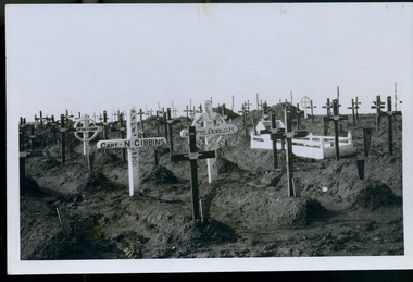
Soldier's cemetery, les chandler_a00171.tif
Rows of graves from the Battle of Fromelles, then called Flerbaix. Among the graves is that of Captain Norman Gibbins, 55th Battalion, born in Ararat Victoria. A Gallipoli veteran, at Fromelles, Gibbins fought a desperate rear guard bombing action while under heavy German attack. It allowed many Australians including the wounded to get back to the safety of their own lines. When his path was blocked by dead and wounded Gibbins stood up and was fatally shot. His body was recovered and moved seven kilometres behind the lines where his grave was one of 111 Australians initially buried at Sailly-sur-la-lys. ww1, world war 1, cemetery, fromelles, flerbaix, norman gibbins, aif, a.i.f -
 Wodonga & District Historical Society Inc
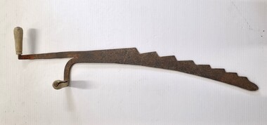
Tool - Hay Bale Saw
Hay bale saws were a common agricultural tool. Ed Nolt, a Dutch resident of Pennsylvania, USA, invented the prototype for the small square baler back in the 1930s. His patent was purchased and mass produced during the 1940s. These balers quickly spread throughout the world and became a common agricultural machine. The hale bale saw was used to cut up the bales when distributing feed to livestock. As modern agricultural production has turned more to the use of large round bales, these small saws have become obsolete. This saw was used by a farmer in North Barnawatha approximately 18 kilometres from Wodonga, Victoria.This saw is representative of the agricultural tools in the mid to late 20th century.A metal saw with 2 wooden handles. The saw has a very coarse serrated edge. One of the handles is parallel to the blade, and the other handle is perpendicular to the blade.agricultural tools, hay bale saws, north east victoria -
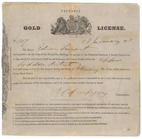 Old Colonists' Association of Ballarat Inc.
Document - Gold License, Gold License issued to Edwin Smart, 28/01/1853
The Old Colonists Association Minute Book records: 'James Smart presented the Association with a Gold Diggers License dated 28th January 1853, it being resolved a vote of thanks be recorded.' The headwaters of the Loddon River rise on the northern slopes of the Great Dividing Range east of Daylesford. The river rises below Musk near Trentham and Lyonville from where it heads northward to Glenlyon and on to Loddon Falls. It then flows generally northward through Guildford and Newstead, 40 kilometres (25 mi) west of Bendigo, then towards the Murray River. The Upper Loddon Plains is within the traditional lands of the Dja Dja Wurrung people.Gold License issued to Edwin Smart on 28 January 1853 at the Upper Loddon.gold license, edwin smart, gold mining, james smart, upper loddon -
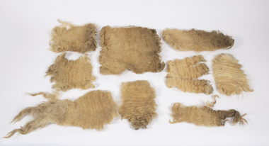 Warrnambool and District Historical Society Inc.
Animal specimen - Lincoln Sheep Fleece, early 21st century
These pieces of fleece of a Lincoln sheep come from the property, Carrakoorte, in Grasmere, 13 kilometres from Warrnambool. Lincoln sheep are a large British breed producing strong, heavy wool. Carrakoorte was established in the 1850s and the Manifold family members were the owners in the late 19th and early 20th centuries. In 1886 William Henderson, a dairy farmer and cheese maker, became the manager of Carrakoorte. He purchased the property in 1911 and the Henderson family retained the property until 2012 when the owner, Jim Henderson died. Carrakoorte was renowned for the breeding of Ayrshire Stud Dairy Cattle. The Lincoln fleece pieces are included in our collection of Henderson/Carrakoorte historical items.This fleece is of interest as a memento of the Henderson property, CarrakoorteThese are nine pieces of fleece of a Lincoln sheep. They are light brown in colour and have a curly texture. carrakoorte property grasmere, lincoln sheep, henderson family grasmere