Showing 622 items
matching black mountain
-
 Montmorency/Eltham RSL Sub Branch
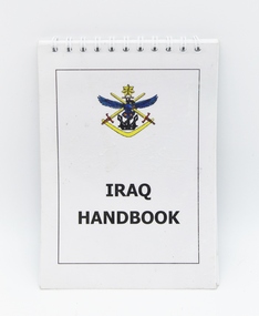
Booklet - IRAQ Handbook, February 2003
Ready reference handbook for Australian Defence Force personnel serving in Iraq.Ready reference handbook for Australian Defence Force serving in Iraq.Small rectangular printed spiral bound black and white unclassified Iraq handbook used as a ready reference for Australian Defence Force personnel sereving in Iraq. Handbook contains nine sections over 58 pages. Front and back clear plastic protective cover. Colour logo of the current Australian Defence Force on the front cover. Colour logo of the Australian Theatre Joint Intelligence Centre and date on back cover. Colour logo of the Australian Defence Force printed on the front cover. The words "Iraq Handbook" printed on front cover. Black printed rectangular line border on front cover. Black printed rectangular line border on back cover. The words "Printed February 2003" printed on back cover. Colour logo of the Australain Theatre Joint Intelligence Centre printed on back cover. The handbook contains a purpose page and nine sections of contents over 58 pages.iraq war. handbook. australian defence force. unclassified. -
 Montmorency/Eltham RSL Sub Branch
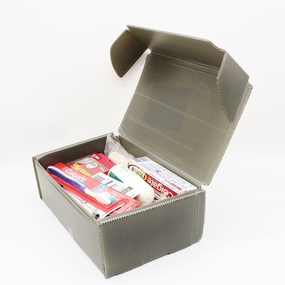
Functional object - Defence Personal Items Pack male, May 2003
Used by male Defence personnelOlive green plastic corrugated cardboard rectangular box with folding lid containing 18 miscellaneous male grooming, washing and deodorant items. A black medium biro pen is also included. A black printed white label is located on the outside of the box lid.RMSDAS 44 Biloela St Villawood NSW Ph 02 9728 5914 Fax 02 9728 5901 Defence Personal Items Pack Male Order No 293064 NSN No: 8465 66 145 6306 05/2003 -
 Montmorency/Eltham RSL Sub Branch
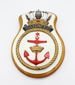
Plaque, The Navel Crown motif is a post 1970 version
The HMAS Sydney (I) was a famous First World War warship. This crest is the official badge of the HMAS Sydeny (I), (II) and (III)A wooden plaque with decorative white, gold and coloured motifs, including a gold Mural crown, a red erect anchor with a red six pointed star above it, all surrounded by gold rope. Above the rope there is the word "Sydney" written in gold letters on a black scroll, with the Navel Crown motif above."Sydney" appears capitalised on the front of the plaque.hmas sydney, australian navy, war, ships, plaque, insignia, anchor -
 Montmorency/Eltham RSL Sub Branch
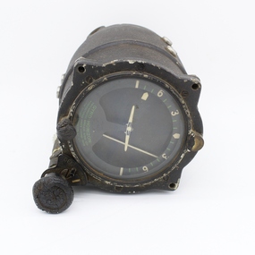
Instrument - Instrument, Aircraft, Artificial Horizon
Cylinder shape a few scratches and showing wear and tear, Glass window with cream and green numbers. With black matt baked on paint.Behind glass reads - GYRO HORIZON AMALGAMATED WIRELESS (A/SIA), MANUFACTURED UNDER LICENSE FROM THE SPERRY GYROSCOPE CO. LTD Label reads - Serial No A.W.A /2739-, Part no 643720R, Patented Aust. 110675, 18.8.39, R.A.A.F. Ref no G6A/3330gyroscope, r.a.a.f, artificial horizon, aircraft, sperry -
 Montmorency/Eltham RSL Sub Branch
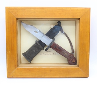
Weapon - AK-47 Bayonet and Scabbard mounted in display case
Chris Albers served in Cambodia, with the UN Forces late 90's Russian AK-47 bayonet and scabbard cross mounted with metal wires in stained light walnut colour wooden glass fronted display case. Leather strap and buckle attached to mounting end of bayonet. Nylon hanging cord for wooden case stapled to back of wooden case. Black masking tape covering mounting wires on back of wooden case. White label with barcode on rear of case.Russian AK-47 bayonet and Scabbard. 0040 Memory Frame 10" XS with barcode on white label.cambodia, un forces, ak-47, bayonet, scabbard -
 Montmorency/Eltham RSL Sub Branch
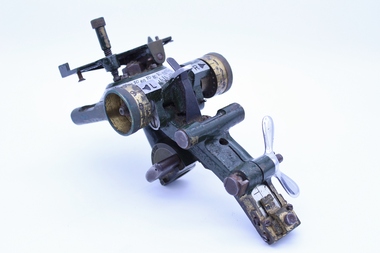
Instrument - Sight, Mortar, Mk1, 3 Inch, WWII, 1941
Manufactured during World War II Manufactured during WWIIWWII 3 inch Mortar sight, Mk1, Lensatic. Dark green coloured brass metal body with brass fittings. Aluminium coloured circular dial with black painted numeric (zero to 180 degrees) and alphabetic (left and right) markings. Silver coloured butterfly nut fitting on lower body for sliding clamp adjustment. Steel screws and nut fittings. Two clear glass levelling bubbles are provided. Left and right adjustment dials, locking clamp provided for fitting of sight to a circular post fitting.SAR 1941 24-36 DD02124-3 TO LOCK (with direction arrow) L R (with arrow point marking) 0 to 9 R 0 to 9 L 0 to 180 R 0 to 180 L 210 GRS SEC CHARGE II I MR 2454 graticule markings 1400 to 600 Graticule markings 2700 to 10003 inch, mortor, sight, australian defence forces, ww ii -
 Montmorency/Eltham RSL Sub Branch
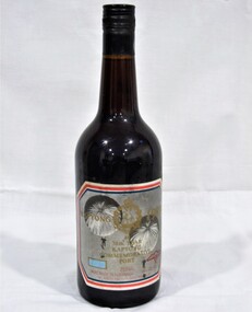
Souvenir - 38th Anniversary Bottle of Port commemorating the Battle of Kapyong, Korea, 1951, 1989
Black bottle with long neck, made of black glass with black metal screw top and label front and backKapyong 1989 is at top of label with emblem between, then 111, 38th year, Kapyong, Commemorative Port. 750 ml. Wine made in Australia. 18% Alc/vol. Mt Aitken Vineyard Gisborne Vic On the back of the bottle -
 Montmorency/Eltham RSL Sub Branch
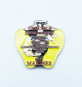
Souvenir - Commemorative Medallion, Quartermasters sales and service inc
An irregular cloissonne medallion Yellow with gold illustrations and red and gold writing on one side and silver gun, bayonet and fist on a black background with red and silver writing Crucible Enter recruits 54 hours 48 miles 49 lbs of gear 36 stations 29 problem solving exercises 8 hrs sleep 3 MRE’s Exit Marines One mind any weapon the military mint, military medal -
 Montmorency/Eltham RSL Sub Branch
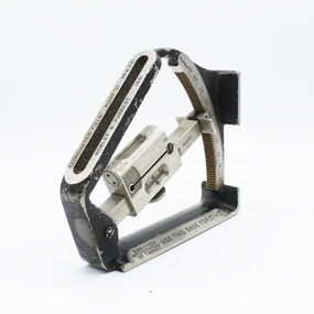
Equipment - Clinometer, 1941
This model clinometer used in both WW1 and WW2 for checking artilllery and mortar barrel anglesPrecision instrument widely used by Alliied forces in two warsMetal with some parts painted black. Device comprises a segment of a circle with an adjustable radial arm with bubble level on a slide attached"Clinometer Field Mark VI No. A.221" Noblet and Forrest 1941" "Direction of Target" with arrow. "Use this Base for 0° - 45°" "45° - 90° Target" with arrow Circle segment graduated with 0 - 44 degrees on side, 45 - 89 degrees other side. Arm graduated 0 - 60 minutes both sides clinometer, artillery instruments -
 Montmorency/Eltham RSL Sub Branch
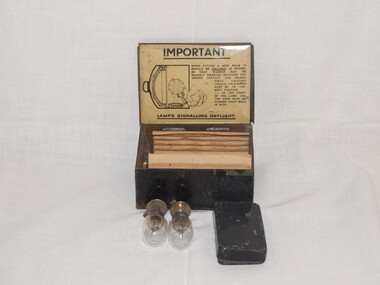
Equipment - Lamps, Signalling Daylight, Short Range, Box Spare MKII PMG 1942, 1942
Tin box, scratched, rusty, black colour in appearance with writing on internal lid. Two bulbs, small tin containing clips, nuts and bolt. Front of lid LAMPS, SIGNALLING DAYLIGHT BOX SPARE PARTS MKII PMG 1942, Internal Lid - IMPORTANT When fitting a new bulb it should be INCLINED as shown, so that washer may be readly inserted between the spring contact and bridge piece. lighting tongue in washer must be in correct position......to the front of the lamp and the stem must be pushed right back in slot. LAMPS SIGNALLING DAYLIGHT.signalling, daylight, short range, lamps, spare parts -
 Montmorency/Eltham RSL Sub Branch
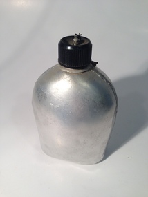
Equipment - Canteen, Water, Circa 1960s
Used by Australian Army circa 1960s.Used by Australian Army circa 1960sUnpainted US style aluminium canteen formed by two seam welded halves (front and back sides) with an aluminium threaded top for attaching a top to the water canteen. The water canteen has a black plastic screw top lid attached to the neck by a metal link chain. The front of the water canteen is bowed outwards with the back being flat with a curved top doorway shaped indentation.australian army, water canteen, aluminium -
 Montmorency/Eltham RSL Sub Branch
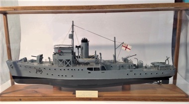
Unknown - Scale model HMAS Maryborough (1)
Model of the ship served on by W Thomson during WWII.Scale model of the HMAS Maryborough that was operated by the Australian Navy during WWII.Grey and black painted plastic and wood scale model of the Bathurst class HMAS Maryborough (1940 to 1946) minesweeper (commonly known as corvettes) mounted in a wooden frame glass sided and top case. It has cotton rigging with metal anchor chains. An inscribed metal plate is located on the front glass side. The upper of the model is painted grey, and the bottom black. J195 is painted in black lettering on the bow of the model.J195 H.M.A.S Maryborough 1940 - 1946 Made by W. Thomsonmodel, hmas maryborough, bathurst class, minesweeper, corvette -
 Montmorency/Eltham RSL Sub Branch
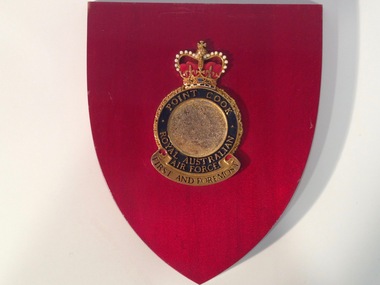
Decorative object - RAAF Point Cook Crest
Metal RAAF Point Cook crest mounted on a small dark red coloured plaque. The plaque has a mounting slot on the back and foward sloping curved sides meeting at a lower point. The circular RAAF crest has a jeweled crown at the top, black lettering at the bottom, and gold lettering on a circular blue enamel background surrounding a brown coloured line drawing of an eagle flying over water with the sun in the background.Point Cook Royal Australian Air Force First And Foremostraaf, point cook, crest, metal, plaque -
 Montmorency/Eltham RSL Sub Branch
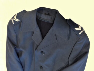
Uniform - RAAF Service Dress Coat, 1992
Donated by Cpl Bramley who was in charge of our Catafalque party ANZAC Day 2006Blue Dress coat. Corporals stripes on shoulder. Black plastic buttons.Sewn Patch ADI Vic 1992, 8410-66-105-.1389, Size 80, Service No W514342, Name M. Ackroyd clothing, coat -
 Montmorency/Eltham RSL Sub Branch
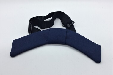
Uniform - RAAF Service Dress Bow Tie, 1992
Donated by Cpl Bramley who was in charge of our Catafalque party ANZAC Day 2006 Blue cotton, Black elastic strap. Sewn Tag Noone Image Wearclothing -
 Montmorency/Eltham RSL Sub Branch
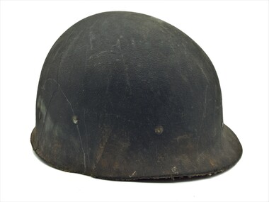
Headwear - Helmet Liner, US M1, Vietnam era
Vietnam eraVietnam eraFibre helmet liner used with the US M1 steel helmet. The outside of the liner is a dark green colour and the inside brown. The liner contains a webbing suspension system that can be adjusted to fit the wearer's head. The suspension webbing has a three-strap olive green nylon webbing in an asterisk pattern stretching across the inside of the liner. A brown leather and nylon webbing sweatband is mounted around the inside of the liner with metal clips. The suspension system is mounted at six points with metal rivets and clips. Metal clips are riveted to either side of the liner and at the rear.Cat. No. 8415-50-753-5792. Written in black texta is MORCOM, 37019 an 1966-67.helmet, headgear -
 Montmorency/Eltham RSL Sub Branch
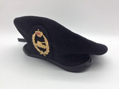
Headwear - Beret, Spanish, 1987
Representative Spanish Army armoured corps beret. Good conditionBlack wool beret with black leather trim and black synthetic cloth liner. Two riveted eyeletes 5mm diameter. Cap badge: gilded metal tank 1/4 front view, surrounded by laurel wreath, surmounted by a crown with red enamel liner. Badge mounting: oval, stiffened, black cloth backing. between cap and lining. Cloth, with clear plastic covering, manufacturer's label. Manufacturer's label on liner- "Boinas Elosegui S.A. Anu 1987 year of manuf. Lana 100% wool (pictogram care instructions) Talia 58 sizeheadgear -
 Montmorency/Eltham RSL Sub Branch
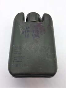
Insect Repellent Lotion, Australian Army, Vietnam era, Circa 1960s
Vietnam era Australian Army small plastic insect repellent container. Olive green in colour with instructions for use printed in black ink on one side. The plastic container is manufactured in two pieces, with a screw threaded plastic cap. Under the cap, the top of the container contains a small hole to enable the contents to be squirted out.INSECT REPELLENT LOTION Instructions for use and warning label insect, repellent, lotion, plastic, australian army, vietnam -
 Montmorency/Eltham RSL Sub Branch
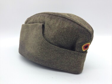
Headwear - Forage Cap, German, Post-war, 1968
Standard West German Army uniform item for that period.Olive drab woolen forage or side cap with cotton liner. Olive diamond-shaped backing with yellow, red, black embroidered rosette cap badge. Manufacturer's off-white label sewn to lining. Label - red ink stamp 'BAMBERGER MUTZEN INDUSTRIE' black ink stamp 'U5 I 2d/11/15644/0048/8, VII/1968, 56, 8405-12-138-8899' Label over-stamped with large 'A'headgear -
 Montmorency/Eltham RSL Sub Branch
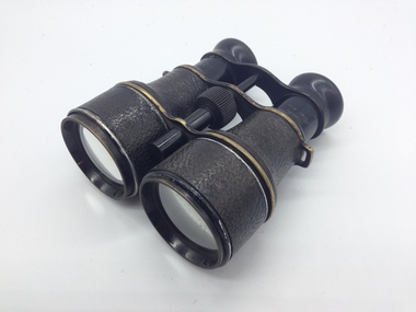
Binoculars, World War 1 era
World War eraWorld war 1 eraWorld War 1 era black coloured brass and steel 5x50 field binoculars, manufactured by Jagdglas Voigtlander in Germany. The front lens has an extendable metal shade cover. The binoculars body and extendable shade covers have a leather-look embossed pattern. Three brass pieces hold the two sides of the binoculars together and mounts the circular plastic turnbuckle that allows the binoculars to be adjusted. The two rear eye pieces are black plastic.Jagdglas Voigtlander 5x The left barrel of the binoculars has the markings 6 W and the broad arrow.binoculars, world war 1, germany, 5x50, military -
 Montmorency/Eltham RSL Sub Branch
Headwear - Cap, Peaked, US Army Dress Blue
Believed to be US Army Infantry dress blue uniform cap introduced in 1954 Black peaked cap with patent leather peak. Peak is blue underside, and black upper with a row of gold oak leaves and thin leather edging. Black leather chip-strap is secured by two gilt buttons, 17 mm diameter, embossed with a hunting horn surrounded by a wreath of laurel. The sky blue hatband is edged with 2 mm wide gold embroidery. The inner headband is brown leather-like material and the lining is red fabric.Under the lining a metal tab supports the crown at the front of the cap and crown edge is reinforced by wire. The cap badge is missing (2 off 32 mm center holes) noneheadgear -
 Montmorency/Eltham RSL Sub Branch
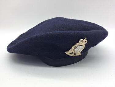
Beret, Navy Blue
Navy Blue Wool Felt Beret with RAAOC (Royal Australian Army Ordnance Corps) badge. Black polyester/cotton edging and adjustment tape. (inner lining has been cut out) Grey felt badge backing inside beret.Nilheadgear, beret -
 Montmorency/Eltham RSL Sub Branch
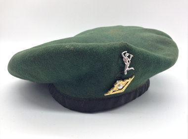
Beret, Green
Green Wool Felt Beret with Royal Australian Corps of Signals badge missing crown and Mercury's ankle broken from base of badge. Black polyester/cotton edging, adjustment tape and lining with manufacturers label.Inside: "Beret Mnfrs.Pty., Ltd. Victoria Australia Size 7 1/8"headgear, beret -
 Montmorency/Eltham RSL Sub Branch
Beret, Black
Black Felt Beret with RAR (Royal Australian Regiment) gilt metal badge. Unlined. Black polyester/cotton edging. Adjustment tape missing. Manufacturer's tab sewn to edging.Tab "Christie's Sydney" Stamp inside mostly indecipherable except for "PURE WOOL"headgear, beret -
 Montmorency/Eltham RSL Sub Branch
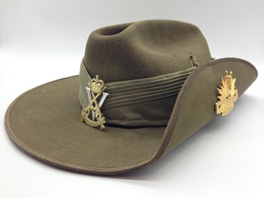
Headwear - Slouch hat, 1990
Standard issue hat to Army Reserve unit. Representative uniform itemKhaki Australian Army slouch hat (fur felt) with khaki cloth puggaree. Cloth black over red rectangular colour patch on right hand side of puggaree. Gilt metal Royal Victoria Regiment cap badge on front of puggaree. Australian Army rising sun badge on left side turned up brim. Brown vinyl sweat band. Chin strap missing. Hat mounted on plywood carrying board. Bardsley Hats 1990 broad arrow Fur felt 54 gold stencil on sweat band. "319232 READ R" handwritten inside sweatband "Sgt Nicholls" handwritten brown marker pen on mounting board slouch hat, australian army, australian army slouch hat, bardsley hats -
 Montmorency/Eltham RSL Sub Branch
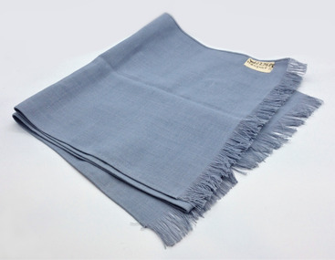
Clothing - Scarf
Pale Blue, linen/cotton material with fringing at each endWhite cotton tape stitched to corner of scarf with W227689 Houget D . Written in black ink.clothing, scarf -
 Montmorency/Eltham RSL Sub Branch
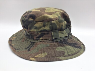
Hat, Utility, Camouflaged
Camouflage pattern (black, green, brown, khaki) cotton 'giggle' hat. Four brass ventilation fittings in crown. Manufacturer's label sewn inside. Label side 1 - John Star Pty. Ltd. NSW 02-669-1066 Name ............ (note - no name shown) No. ................ (note - no number shown) 100 % COTTON Made in Hong Kong" Label side 2 - care instructions headgear, combat -
 Montmorency/Eltham RSL Sub Branch
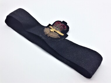
Accessory - WRAAF Hat Band with Badge
Owned and donated by local member.Black woven cotton hat band for WRAAF (Womens Royal Australian Air Force) officers. Cloth embroidered badge with padded gold bullion and red velvet crown, gilded metal eagle and gold bullion laurel leaves. Badge model is late 1960s and after - bird is Australian wedge-tailed eagle.Noneheadgear, hat accessory -
 Montmorency/Eltham RSL Sub Branch
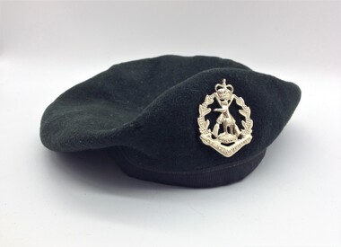
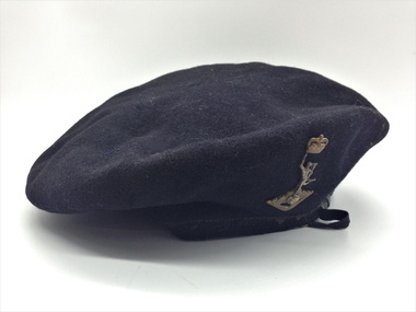
Beret, Black, R.A.Signals
Black wool felt beret with black nylon trim and tie tape. Royal Australian Corps of Signals cap badge. Black cloth lining with manufacturer's label and name / number label. Label "Beret Mnfrs Pty Ltd. Victoria. Australia. Size 6 3/4 " Name Tag "3162456 Dibben" hand writtenheadgear, beret -
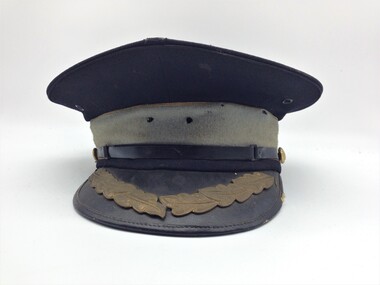
 Montmorency/Eltham RSL Sub Branch
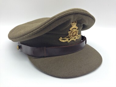
Cap, Peaked, Royal Australian Artillery, 1969
Standard RAA cap for 1950 / 1960 periodKhaki cloth peaked cap with Royal Regiment of Australian Artillery gilt cap badge (Queen's crown) with brown leather chin strap and gilt AMF 12mm diameter buttons. Brown leather sweat band and clear plastic liner. Manufacturer's label. Manufacturer's and Inspectors stamp inside sweat band. Manufacturer's Label "Commonwealth Government Clothing Factories, Melbourne" red printing on white label. Overstamped "S56 6 7/8" in black ink Manufacturer's and Inspection stamp inside sweatband, partly indecipherable. No personal I.D.headgear, cap