Showing 653 items matching " inside out"
-
 City of Moorabbin Historical Society (Operating the Box Cottage Museum)
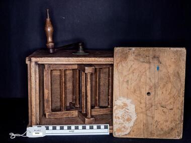
Churn, small domestic butter, c1880
A butter churn is a device used to convert cream into butter. This is done through a mechanical process, via a crank used to manually turn a rotating device inside the barrel shaped churn. The agitation of the cream, caused by the mechanical motion of the device, disrupts the milk fat. The membranes that surround the fats are broken down, subsequently forming clumps known as butter grains. These butter grains, during the process of churning, fuse with each other and form larger fat globules. Air bubbles are introduced into these fat globules via the continued mechanical action of the churn. The butter grains become more dense as fat globules attach to them while the air is forced out of the mixture. This process creates a liquid known as buttermilk. With constant churning, the fat globules eventually form solid butter and separate from the buttermilk. The buttermilk is then drained off and the butter is squeezed to eliminate excess liquid and to form it into a solid mass. Then rinsing could be done simply by washing in water, followed by draining, salting and working or "kneading" the butter with a pair of wooden butter pats, or with bare hands. This is a paddle churn, a barrel that contains a paddle, which is operated by a handle. The paddle churned the butter inside the container when the handle was turned. Early settlers had to be self sufficient, growing their own vegetables, making tools and clothing and usually had a house cow to produce their milk supplyThis domestic butter churn is an example of the skill of the pioneer craftsman, carpenters and tool makers c1900. As pioneers and early settlers had to be self sufficient they usually kept a dairy cow or 'house cow' to provide milk for drinking and for butter and cheese to made by the family.A small wooden, domestic butter churn with a lid and a crank that manually rotated the paddle inside. E. CHERRY / MAKER / GISBORNE / VICTORIA / Apioneers, early settlers, market gardeners, moorabbin, brighton, cheltenham, dairy products. dairy farmers, milk, butter, dairies -
 Geelong RSL Sub Branch
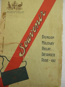
Souviner Program, No makers listed, Dunlop Military Relay ... Despatch Ride 1912, 1912
In 1912 there was a Military Relay Despatch Ride through South Australia, Victoria and New South Wales. The purpose of the ride was to deliver a despatch in the quickest possible time by road through the three states mentioned. The ride was carried out under the auspices of the Dunlop Rubber Company and involved cyclists, motor cyclists and motorists.This is an original program of the event that was carried out in 1912. The program details the list of participants, a map of the route taken and statements of appreciation from the Military and the Promoters', there is also a message of greeting from the Military Commandant, South Australia to the Military Commandant, New South Wales.A cardboard cover program with white thick pages inside.On the front cover a Coat of Arms, a red stripe with souviner written in the stripe and Dunlop Military Relay ... Despatch Ride - 1912.military relay, 1912, despatch ride, dunlop rubber company -
 Derrinallum and Lismore Community Association - History Group
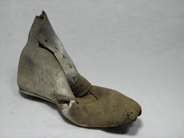
Boot, c.1870
This boot was found hidden in an alcove in a chimney in one of the first houses built in Lismore Victoria during the mid 1860's. The house belonged to scottish born George Ireland Skene who settled in Lismore in mid 1857 with his wife Elizabeth (nee Nelson) and two young children. November 1857 George had built the first blacksmith shop in Grey Street Lismore and then built his house behind the smithy's. Hiding boots in chimneys is well doucumented in folklore. Old brown leather left foot childs boot. In poor condition the leather has dried out and the front centre of the boot along the eyelets has curled into the inside of boot. The holes are in tact but the laces are missing so is the tounge. The leather is stained with a white powder mildrew. The sole and heel has perished and there is a hole in the toe area.boot, shoe, leather, folklore, concealed, chimneys, hidden, magic -
 Heathcote McIvor Historical Society
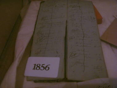
Day Book, Book, 1856
Believed to be long to Routledge Brothers who ran a general store business in heathcote. They also owned a sawmill and quartz crushing battery.one of three books donated to the Museum, were found by the donors father back in the late 1960's while he was working on renovations to a building in heathcote these books had been thrown onto a pile of builders rubble, he retrieved them. when he passed away some years later his son found them while clearing out his effects, have travel through several house changes till 2010 when the son was doing a cleanup and the books were found again he contacted the Historic Society, date back to first settlement of Heathcote, inside writing is in excellient condition, as if it were written yeaterday. give a daily account of purchases by locals.gives us an insight into persons living and working in Heathcote McIvor district. Not many early items of this era left .Day book, oblong, leather cover, Day book gold blocked on front coverday book routledge, brothers -
 Yendon History Group
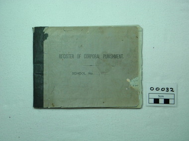
Book, school punishment, REGISTER OF CORPORAL PUNISHMENT School No. 719, printed before 1920
This book was used as a record of corporal punishment to children at the Yendon State School between the 1920's until 1972. It has the signatures of the teachers of the period and dated. Inside the front cover it has a list of rules related to disipline and how the corporal was to be carried out. Grey book with No.719 on front cover which was used as a register for corporal punishment. It has had several pages torn out. The first recorded date of entry is 8/6/33 until 22/7/1982.719 on front coveryendon state school yendon primary school yendon public education corporal punishment school discipline -
 Kiewa Valley Historical Society
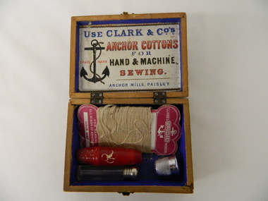
Box Sewing Kit, pre 1952
This "sewing and darning" box was purchased before 1952 (the date that the Clark Brothers merged with J&P Coats). It was in an era where the production and alteration/modification to any household or personal clothing was carried out by a family member/s. This was at the period where self sufficiency in rural and especially remote areas was a requirement and not just a hobby. Clothing modifications and "hand me downs" was a way of life. The long and tiresome journey from home to millinery shops was a great force to ensure that home sewing was carried out in the majority of residential and farm areas.This sewing box was donated by a pioneer family in the Kiewa Valley. Its significance points to an era before the establishment of the Kiewa Hydro Electricity Scheme and the establishment of the Mount Beauty Township. It was a time when the rural industries of the Kiewa Valley was rich in production of beef, dairy products, tobacco leaf and before the mass of alpine adventurers that tourism sparked. It was a time rural enterprises out shone tourism.This wooden sewing box is covered with decorative paper. The lid is fastened to the bottom section with two small hinges each having four screws. Each side is fixed to the other by a mortise groove. At the front of the box is a small clasp for complete closure. The box contains needles, darrning thread, thimble, a glass vial with metal screwtop and a red plastic cylindrical container with a thimble screw on top(contains a small reel with three different cotton thread compartments).On outside lid "FROM A FRIEND. I DO NOT WISH THEE GRANDEUR, NOR YET A STORE OF WEALTH, I WISH THEE RICHER TREASURE, CONTENTMENT, PEACE & HEALTH", On inside lid "USE CLARK & CO ANCHOR COTTONS FOR HAND & MACHINE SEWING ANCHOR MILLS, PAISLEY" Each of the different sewing boxes from the Clark Bros. has a label with different "friend" passages.sewing box, hand stitching, domestic clothes alterations, haberdashery -
 Kiewa Valley Historical Society
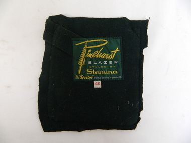
School Blazer Pocket Badge
Mt Beauty Higher Elementary School commenced in 1953 as the need for a secondary school grew with the increase in population due to the Kiewa Hydro Scheme. It became the Mt Beauty High School in 1964. The blazer was worn as part of the winter uniform.Historical: Education in Mt Beauty commenced relatively late so there was less of a tradition. The decision to adopt a uniform is of interest to compare with other schools and the times.Pure wool dark green flannel pocket cut out from a Mt Beauty High School blazer. Emblem is machine stitched and has a yellow wattle decoration outside a yellow frame. Across the top of the frame in yellow 'High School", across the bottom of the frame "Mount Beauty", the 2 sides of the frame are hollow. Inside the frame is a stitched picture with a light blue sky, royal blue mountains with white peaks and a white curved path leads towards the mountains with light green 'paddocks' either side. Inscription on back in yellow and white.Pinehurst / Blazer (in white) / Styled by Stamina / The "Doctor" / Pure Wool Flannel (in white) blazer, school, high school, uniform, mt beauty, emblem, education, clothing, winter -
 Kiewa Valley Historical Society
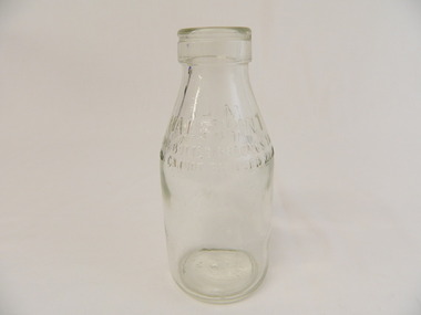
Bottle - Milk, 1950's - 1960's
Bottled milk was bought at the local store. The bottles were re cycled and remained the property of the manufacturer. to encourage their return a deposit was usually paid on them. Pre 1966 liquids were measured in pints.Historical: Dairy farmers lived in the Kiewa Valley and sent their milk to be pasteurised and bottled by a local Dairy Company. The bottles changed shape, size and embossing. Aesthetic: Display showing variations of shape, embossing and size Clear glass small bottle with straight sides nearly two thirds up from the base tapering gently to the opening which has a thick long lip before the opening. Heavy embossing around the circumference on each side where tapering begins. Light embossing on the base.Half Pint Milk This Bottle Belongs to Milk Bottles Recovery Ltd. And Cannot be Used With Out Written Permission Base: '2' Common Seal 'A' with 'G' and 'M' inside the A / '8' / '11' / 'M163'milk, dairy, farmers, kiewa, milk bottles recovery ltd -
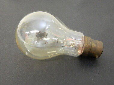 Kiewa Valley Historical Society
Light Bulb - S.E.C.V
This globe is unusual as the filament is coiled and held by 5 points coming from the glass piece inside the globe. This light globe belonged to the State Electricity Commission of Victoria and may have been used for a special purpose on the Kiewa Hydro Electric Scheme.The State Electricity Commission of Victoria built the Kiewa Hydro Electric Scheme using unique equipment to achieve its construction. Clear glass in the shape of a circular bulge around the filament with a metal alloy at the narrow end with 2 small rods jutting out at opposite ends to enable the light to be attached to a fitting. The filament is made of glass and has a very fine wire on each side extending nearly to the top edge of the glass globe. This fine wire is a spiral with each loop connected to each of 3 small fine wires coming up from the top centre of the glass inside. light. electricity. globe. s.e.c.v.. kiewa hydro electric scheme. -
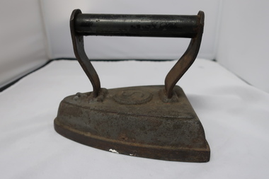 Kiewa Valley Historical Society
Iron - antique
Cast irons were heated on the stove and used to take out creases/wrinkles in cloth. Used before electricity was available. Two irons were often used so that one could be being used while the other heated.Used in the Kiewa Valley prior to electricity being available.Metal cast iron with handle and embossed within a circle the letter S on the top of the iron. The handle has flat metal curved sides which hold a hollow round rod for lifting.Embossed on top of the iron - circle with S inside.antique iron, household item -
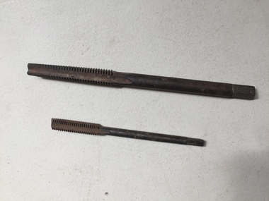 Kiewa Valley Historical Society
Tool - Tapered Thread Tap Tools x2
Used by residents of the Kiewa Valley.Two different sizes - 1. half inch diameter and 2. 5 eighths inch diameter. Steel taper tap creates a thread inside a nut. Screw it into a nut, it takes the metal out and leaves a thread. tapered thread tap tool, tool -
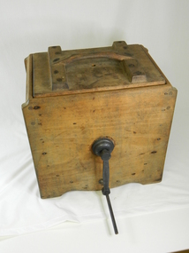 Kiewa Valley Historical Society
Churn Butter - Wooden
This type of butter churn was used around the early to mid 20 century by household and small farms of the Kiewa Valley who kept cows for Milk. The buy product of the milk was cream and butter. Once the cows had been milked, often by hand, women would place the milk in shallow dish, and next morning the cream would be separated from the milk. Or a cream separator machine would be used. The cream would then be churned by the paddles in the butter churner until it formed in butter clumps. Butter Pats would be used to take the butter out and press into triangle butter blocksThis butter churner is significant due to its historical value which explains how butter was made by hand before this process became mechanistically made. Many houses or small farms in the Kiewa Valley had these butter churns to make their own butter for their household or to sell. This has very good interpretation significance as it adds to the history of dairy industry in the Kiewa Valley. Wooden box with a metal handle for turning the blades /paddles /slats inside the box.These blades churn the cream when the handle is turned. There is also a wooden handle and a wooden lid.butter, dairy, milk, manual, domestic, item, food, preparation, dairying, technology -
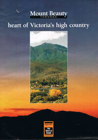 Kiewa Valley Historical Society
Poster Brochure, Mt Beauty Tawonga Heart Of Victoria's High Country, Circa 1995
The Item is a pictorial time piece of the valley and usage, farms,industry,town area, vegetation and winter snow levels Historical and the social-economical development at circa 1995 of land usage and residential buildings style.Major social events e.g. Festival of the Bogong Moth and the Mt Beauty Mardi Gras. It is also a good historical record of tourism campaigns of the Alpine Shire and Mt Beauty Chamber of Commerce. Also see "KVHS 0125"Brochure folds out from a 20.5cm x 29.5cm to 82cm x 29.5cm poster type documentinside panoramic photo of snow tipped alpine mountain range incorporating the Mount Beauty township, farming area of the Kiewa Valley and relevant tourist orientated informationtourism mt beauty tawonga photographs, victorian alps -
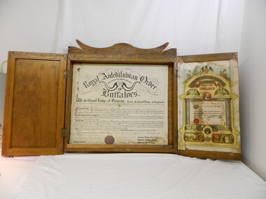 Kiewa Valley Historical Society
R.A.O.B. Members' Board
Originated in the United Kingdom in 1822 with a motto "No Man Is At All Times Wise" and a maxim of "Justice, Truth and Philanthropy". A branch of the Royal Antediluvian Order of Buffaloes was formed at Bogong by Grand Lodge Officers from Melbourne and other members. The ceremony was held at Lewis Camp Mess (Kiewa Hydro Electric Scheme) with a world record of 78 new members initiated and a world record of over 100 pounds was raised. Another branch, No. 150, was opened in Mt Beauty. The Bogong and Mt Beauty lodges combined in 1948 and organised a Christmas treat for all children of the State Electricity Commission of Victoria working on the Kiewa Hydro Electric Scheme.Historical: The Bogong R.A.O.B. was formed circa Sept. 1946 and the Mt Beauty R.A.O.B. in 1948. The Members Board, the 78 members initiated and the money raise indicate that it was a popular organisation in Bogong and then in Mt Beauty during the construction of the Kiewa Hydro Electric Scheme. This club also shows how important social clubs were in making up part of the community thus making it socially historic as well. This board has good interpretive capacity as it tells the story of this club which was important to the community at the time. Large hollow wooden box with 2 wooden doors at the front that open out the from centre to a hollow box. Attached to the front of the box, at the top, is a wooden decoration with curved edges along the top. In the centre of this are the letters R.A.O.B.- the letters having been carved out of the wood and then filled with a different wood. Both doors have steel attachments and a locked padlock hangs on the door on the left. Inside the box is a white paper sign with black writing backed onto masonite. Inside the right hand side door a coloured paper sign is attached."R.A.O.B." top centre of box. "Royal Antediluvian Order of Buffaloes" etc. on black and white sign inside box. "Mt Beauty Lodge No. 150. This is to certify that Brother (blank) initiated into ...on 19th March 1949 ....signed by Chas / Chris A. Angus, Secretary" on coloured paper inside right hand side door.royal antediluvian order of buffaloes. bogong. mt beauty. charitable organisation. kiewa hydro electric scheme. lewis camp mess, clubs, societies -
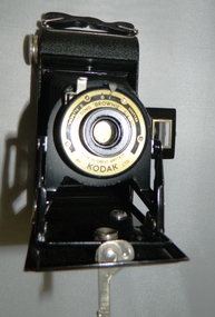 Kiewa Valley Historical Society
Camera Box Brownie Folding, Six 20 Folding Brownie KodetteII, Circa 1948 to late 1970s
This camera was made for the mobile photographer and the camera manufacturer Kodak was at the peak of production. Mr. George Eastman, the company's founder, who invented roll film, which could withstand the outdoor activities and therefor replaced photographic plates. In 1900, the Box Brownie camera was first released Kodak's motto was' "You push the button, we do the rest," The film used in this camera was Kodak Verichrome 620 introduced in 1936 and only went out of production 2009. This camera was a vintage 1970s one. Between 1963 and 1970 the company sold 50 million of this type of camera. The production of smaller and more user friendly digital cameras, mainly from Japan finally nailed the coffin lid on the Kodak Company. Ironically, one of Kodak's engineers called Steve Sasson, devised a camera that could save images using electronic circuits. The images were transferred onto a tape cassette and were viewable by attaching the camera to a TV screen, however Kodak tried to maintain its photographic film products beyond its "use by date". In1975 Kodak becomes the first company to make a digital camera, however the Japanese manufacturers could make smaller and more compact cameras ending Kodak's monopoly and eventual demise.This particular "box brownie" was used by Margaret Shefford, nee Turner, who with her husband retired, in the 1980s, to Mount Beauty. The camera was purchased in the 197's and used on their cruise to England. The significance of this item is that at the time of its introduction to Mount Beauty the camera was a "state of the art", for general public, camera introduced by an ever increasing influx of retirees. This identifies the Kiewa Valley not only as an attraction for sightseers and overseas tourists but also retirees. The social implications of this trend will continue to provide a broader requirement for medical and other facilities geared up to the requirements of an aging population. As a lot of cities in Australia have increasing levels of violence (mainly drug related) rural "retreats" are becoming more sought after by sections of "the gentle populous"This is a black metal rectangular camera, rounded on the ends and has silver colored fittings(stainless steel) and a small leather handle on hinges the left side (facing the lens). The folding lens and shutter component fold out from the main compartment. Two metal arms swing out and hold the lens and collapsible lens body to the required length. When not in use this collapsible (folding) lens extension is fastened to the main body structure providing security and preventing damage to the folding material. The camera has a collapsible eye piece or view finder at the top end. The right hand bottom end has a cylindrical film wider (polished steel). Inside there are two cylindrical cavities, one holding the roll of unexposed film and the other (winder) end a cylinder onto which the unexposed film is wound through for each picture frame. There is a locking mechanism to hold the folding lens structure to the main box structure. See KVHS 0419B for its carrying caseNo external makings but when the lens is folded out it exposes manufacturing information on metal base around the lens " Kodette II B I shutter"(B= Bulb and I= Instant), underneath this, in larger print, is "'FOLDING 'BROWNIE' SIX - 20" below the lens and in smaller print, "made in Great Britain" and underneath this "by KODAK ltd"kodak kodette ii, folding brownie camera, photography, hobby personal item, tourist gadgets. -
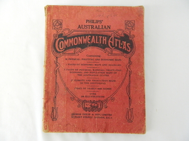 Kiewa Valley Historical Society
Atlas Australian Commonwealth, Philips' Australian Commonwealth Atlas, 1944
This atlas, printed in 1944, details not only the geographic and political boundaries of the world as it was at that time but also the snap shot of life of the time. This snap shot in time covers the major Australian cities, the major farming, grazing, industrial and sporting/recreational activities. Also there are snap shots of similar activities from other global areas. The period also covered World War II, detailed by a photo of "shell making", munitions, required by Australian soldiers. The great political and territorial changes made as a result of World War II can be clearly identified for example , Israel (the Jewish homeland). The various prewar colonies of major European nations.This atlas was used by children of a Kiewa Valley family and shows the value and the general educational exposure that these children had at this time. The rural setting and within the backdrop of a world war did not severely alter the life style of children in this region. The "news reels" shown in cinemas of cities and larger towns were the only visual realisations of major events of global significance available to these children. The information provided by this atlas allowed students to glimpse at what the "outside world" was. The majority of these students would possibly never see these regions for themselves. The great communication facilities of the late 1900s and beyond, was still only science fiction.This atlas has a thick (350 g/m) red cardboard cover with bold black lettering and shading. The cover is set out within a shield like frame. The shield is held up by two square markings, each with a four part circular pattern and a cord entwining two pendulum structures ending with a bowl figure at the bottom. There is a semi circular form enclosing a printed book contents list. The inside cover has the atlas title and contents and the publisher details. The atlas contain 56 pages of world and Australian maps, vegetation and rainfall maps. Within this atlas there are 27 double sided pages of black and white photographs depicting life styles, buildings, landscapes and prominent and significant to Australia males from 1652 to 1944. The pages are of approximately 200 g/m and have the yellow aged appearance.On front cover "Philips' Australian COMMONWEALTH ATLAS" and underneath "Containing" underneath "60 PHYSICAL, POLITICAL AND ECONOMIC MAPS". Publisher George Philip & Son, Limited 32 Fleet Street, London E.C. 4. Inside cover are: written, in freehand and in ink the following names and dates; "J.Muller Form V 1945", "L L Muller Form IV 1946", "N.J. Muller Form I + II + III 1948 +49 + 50" and "D Muller Form I 1949". also handwritten and in pencil is "Peter Leslie". On the last page is a small freehand sketch of Australia in biro.1940s school curriculum, rural education, 1940s atlas, australian atlas -
 Kiewa Valley Historical Society
Book - Non Fiction History, The Kiewa Story, circa 1993
This book provides in chronological order the development of the Kiewa Hydro-electricity scheme from the first concept (1911) to final construction work (1961). It covers the first attempt to utilise the power of the Victorian Alps water system. It started from a private syndicate and developed to the current State Electricity Commission of Victoria. The incentive for the Hydro scheme was to make money and not as an alternative to the carbon producing coal fired power plants. These coal fired power plants were increasing in numbers to service an ever increasing demand made by population expansion, especially in cities and large rural settlements. This demand spiraled up after World War II when there was a tremendous spike in immigration numbers due to refugees and displaced persons in Europe. The ability to utilise the untapped water provided by the winter snow fields, for a higher yield in electricity, was a powerful incentive to overcome the physical hardships in this remote Alpine region. Future power requirements may initiate the re-installation of the other two power stations(Pretty Valley and Big Hill) covered in original Scheme. This publication not only covers the development of the Kiewa Valley region with respect to population (within a socio-economical framework) but also the subtle but yet strong physical changes of a relatively pristine alpine region. The demands that an ever growing regional population places on the environment is clearly documented in print and black and white photographs. The working and living conditions of those who constructed and gave life to this hydro scheme is well documented in this book. It may be viewed as spartan now but was relevantly good at that moment in time, especially for those workers fleeing a devastated European environment. The successful planning and consideration to minimising any intrusion upon the natural alpine forests and high plains can viewed as an example (compared to the Tasmanian Hydro schemes) of how future hydro schemes (an inevitable requirement) will proceed. Most rural towns (in the early 1900s) were built by unencumbered rural based citizens, with the exception of Mount Beauty and Falls Creek. These two settlements were brought into life by a State (Victorian) Authority for a specific function and program. They were a gated community, that is, only open to construction workers involved with the hydro scheme. All facilities within these communities were provided by the State Electricity Commission of Victoria. The impact on the social, financial and individual independency of the community, by the transition from the S.E.C .environment to one of local government (Shire of Bright), had in some cases a severe impact.This hard covered book has a green cover with pictures on the front and back covers. The front cover has a coloured picture of a snow covered Mount Bogong taken from the opposite mountain range. The valley between both ranges has a whisk of mist over it. At the bottom of this picture are three black and white photographs covering the construction of the Kiewa Hydro - Electricity Scheme. On the back cover is a photograph, (black and white) detailing the Bogong village and Junction dam containing lake Guy. The inside front cover is a black and white photograph which details the construction of the West Kiewa tailrace tunnel during April 1951. The inside back cover is a black and white photograph of the concrete pour at the Clover Dam circa 1952. All photographs and sketches are in black and white. The pages are approximately 160 g/m2 and those which have photographs are on gloss paper.Book spine: "The Kiewa Story Graham Napier Geoff Easdown" alongside this is a white framed circle with white spokes radiating out and underneath in white lettering SECkiewa valley, hydro scheme, victorian alpine region, electricity generators, graham napier, geoff easdown -
 Eltham District Historical Society Inc
Ledger, Eltham Road District. Assessment for the Year ending Oct. 14th, 1858, 1857c
The Eltham Roads Board was established in 1856. This is a unique significant record of early settlers in the Shire of Eltham. One of 6 early rate books. This is among the oldest items in the EDHS collection. An article in the Eltham and Whittlesea Shires Advertiser Friday 21 Nov 1941 Page 5 titled: District's Early History states: "The first rate book which is still in existence at the Shire Office is for the year ending October 14, 1858 and is probably the best record possible to indicate the development of the district. At the time properties were rated as follows: Cultivated land. 6d. per acre; pasture land, 1d. per acre: estimated annual value of buildings, etc., 6d in the (pound). The total amount of rate recorded for the year was (pounds)153/14/8. Properties were described as being situated at Lower Plenty, Yarra Yarra, Eltham, Lower Eltham, Kangaroo Ground, Yarra Flats, Diamond Creek and the Yarra."Ledger with printed columns: Number, Name of Occupier, Description, Where situated, Cultivated land, Pasture land, Estimated annual value of buildings, Rate, Remarks. Ledger filled out by hand with 152 entries (not alphabetically arranged). A number of blank pages are included. Copy re-bound in green hard leather look card by Arnall & Jackson Pty Ltd Brunswick, 1968 Inside cover includes a compliments slip taped to the cover from Arnall & Jackson Pty Ltd. with handwritten inscription: "Ian, I hope the hysterical society doesn't get historical about this". Organised 1968 I. Maynard Inside cover includes pasted printed note: RATE OF ASSESSMENT AS FOLLOWS: Cultivated land 6d per acre Pasture land 1 per acre Estimated Annual Value of Buildings, &c., 6d. in the Pound eltham roads board, rate book, rate payers, transaction, pioneers, settlers, 1858, assessment ledger, eltham road district, public records office victoria (prov), rate books, shire of eltham archives -
 Eltham District Historical Society Inc
Ledger, Eltham Road District. Assessment for the Year ending Oct. 14th, 1859, 1858c
The Eltham Roads Board was established in 1856. This ledger includes the signature of Road Board Secretary and Collector Wingrove, a significant person in Eltham's early history. This is a unique significant record of early settlers in the Shire of Eltham. One of 6 early rate books. This is among the oldest items in the EDHS collection. An article in the Eltham and Whittlesea Shires Advertiser Friday 21 Nov 1941 Page 5 titled: District's Early History states: "The first rate book which is still in existence at the Shire Office is for the year ending October 14, 1858 and is probably the best record possible to indicate the development of the district. At the time properties were rated as follows: Cultivated land. 6d. per acre; pasture land, 1d. per acre: estimated annual value of buildings, etc., 6d in the (pound). The total amount of rate recorded for the year was (pounds)153/14/8. Properties were described as being situated at Lower Plenty, Yarra Yarra, Eltham, Lower Eltham, Kangaroo Ground, Yarra Flats, Diamond Creek and the Yarra."Ledger with printed columns: Number, Name of Occupier, Description, Where situated, Cultivated land, Pasture land, Estimated annual value of buildings, Rate, Remarks, Arrears collected, excused, unoccupied, uncollected and amount actually collected. Ledger filled out by hand with 173 entries (not alphabetically arranged). A number of blank pages are included. Inside cover includes pasted printed note: RATE OF ASSESSMENT AS FOLLOWS: Cultivated land 6d per acre Pasture land 2d per acre Unalienated Pasture Land 8d per Acre Estimated Annual Value of Buildings, &c., 6d. in the Pound eltham roads board, rate book, rate payers, transaction, pioneers, settlers, wingrove, 1859, assessment ledger, eltham road district, public records office victoria (prov), rate books, shire of eltham archives -
 Eltham District Historical Society Inc
Ledger, Eltham Road District. Assessment for the Year ending Oct. 14th, 1860 (Version 1), 1859c
The Eltham Roads Board was established in 1856. This is a unique significant record of early settlers in the Shire of Eltham. One of 6 early rate books. This is among the oldest items in the EDHS collection. An article in the Eltham and Whittlesea Shires Advertiser Friday 21 Nov 1941 Page 5 titled: District's Early History states: "The first rate book which is still in existence at the Shire Office is for the year ending October 14, 1858 and is probably the best record possible to indicate the development of the district. At the time properties were rated as follows: Cultivated land. 6d. per acre; pasture land, 1d. per acre: estimated annual value of buildings, etc., 6d in the (pound). The total amount of rate recorded for the year was (pounds)153/14/8. Properties were described as being situated at Lower Plenty, Yarra Yarra, Eltham, Lower Eltham, Kangaroo Ground, Yarra Flats, Diamond Creek and the Yarra."Ledger with printed columns: Number, Name of Occupier, Description, Where situated, Cultivated land, Pasture land, Estimated annual value of buildings, Rate, Remarks, Arrears collected, excused, unoccupied, uncollected and amount actually collected. Ledger filled out by hand with 177 entries (not alphabetically arranged). A number of blank pages are included. Inside cover includes pasted printed note: RATE OF ASSESSMENT AS FOLLOWS: Cultivated land 6d per acre Pasture land 2d per acre Unalienated Pasture Land 8d per Acre Estimated Annual Value of Buildings, &c., 6d. in the Pound eltham roads board, rate book, rate payers, transaction, pioneers, settlers, wingrove, 1860, assessment ledger, eltham road district, public records office victoria (prov), rate books, shire of eltham archives -
 Eltham District Historical Society Inc
Ledger, Eltham Road District. Assessment for the Year ending Oct. 14th, 1860 (Version 2), 1859c
The Eltham Roads Board was established in 1856. This is a unique significant record of early settlers in the Shire of Eltham. One of 6 early rate books. This is among the oldest items in the EDHS collection. An article in the Eltham and Whittlesea Shires Advertiser Friday 21 Nov 1941 Page 5 titled: District's Early History states: "The first rate book which is still in existence at the Shire Office is for the year ending October 14, 1858 and is probably the best record possible to indicate the development of the district. At the time properties were rated as follows: Cultivated land. 6d. per acre; pasture land, 1d. per acre: estimated annual value of buildings, etc., 6d in the (pound). The total amount of rate recorded for the year was (pounds)153/14/8. Properties were described as being situated at Lower Plenty, Yarra Yarra, Eltham, Lower Eltham, Kangaroo Ground, Yarra Flats, Diamond Creek and the Yarra."Ledger with printed columns: Number, Name of Occupier, Description, Where situated, Cultivated land, Pasture land, Estimated annual value of buildings, Rate, Remarks, Arrears collected, excused, unoccupied, uncollected and amount actually collected. Ledger filled out by hand with 177 entries (not alphabetically arranged). A number of blank pages are included. This version was slight changes to version one. Inside cover includes pasted printed note: RATE OF ASSESSMENT AS FOLLOWS: Cultivated land 6d per acre Pasture land 2d per acre Unalienated Pasture Land 8d per Acre Estimated Annual Value of Buildings, &c., 6d. in the Pound eltham roads board, rate book, rate payers, transaction, pioneers, settlers, 1860, assessment ledger, eltham road district, public records office victoria (prov), rate books, shire of eltham archives -
 Eltham District Historical Society Inc
Ledger, Eltham Road District. Assessment for the Year ending Oct. 14th, 1861, 1860c
The Eltham Roads Board was established in 1856. This is a unique significant record of early settlers in the Shire of Eltham. One of 6 early rate books. This is among the oldest items in the EDHS collection. An article in the Eltham and Whittlesea Shires Advertiser Friday 21 Nov 1941 Page 5 titled: District's Early History states: "The first rate book which is still in existence at the Shire Office is for the year ending October 14, 1858 and is probably the best record possible to indicate the development of the district. At the time properties were rated as follows: Cultivated land. 6d. per acre; pasture land, 1d. per acre: estimated annual value of buildings, etc., 6d in the (pound). The total amount of rate recorded for the year was (pounds)153/14/8. Properties were described as being situated at Lower Plenty, Yarra Yarra, Eltham, Lower Eltham, Kangaroo Ground, Yarra Flats, Diamond Creek and the Yarra."Ledger with printed columns: Number, Name of Occupier, Description, Where situated, Cultivated land, Pasture land, Estimated annual value of buildings, Rate, Remarks, Arrears collected, excused, unoccupied, uncollected and amount actually collected. Ledger filled out by hand with 185 entries (not alphabetically arranged) and summary section. A number of blank pages are included. Inside cover includes pasted printed note: RATE OF ASSESSMENT AS FOLLOWS: Cultivated land 6d per acre Pasture land 2d per acre Unalienated Pasture Land 8d per Acre Estimated Annual Value of Buildings, &c., 6d. in the Pound eltham roads board, rate book, rate payers, transaction, pioneers, settlers, 1861, assessment ledger, eltham road district, public records office victoria (prov), rate books, shire of eltham archives -
 Eltham District Historical Society Inc
Ledger, Eltham Road District. Assessment for the Year ending Oct. 14th, 1862, 1861c
The Eltham Roads Board was established in 1856. This is a unique significant record of early settlers in the Shire of Eltham. One of 6 early rate books. This is among the oldest items in the EDHS collection. An article in the Eltham and Whittlesea Shires Advertiser Friday 21 Nov 1941 Page 5 titled: District's Early History states: "The first rate book which is still in existence at the Shire Office is for the year ending October 14, 1858 and is probably the best record possible to indicate the development of the district. At the time properties were rated as follows: Cultivated land. 6d. per acre; pasture land, 1d. per acre: estimated annual value of buildings, etc., 6d in the (pound). The total amount of rate recorded for the year was (pounds)153/14/8. Properties were described as being situated at Lower Plenty, Yarra Yarra, Eltham, Lower Eltham, Kangaroo Ground, Yarra Flats, Diamond Creek and the Yarra."Ledger with printed columns: Number, Name of Occupier, Description, Where situated, Cultivated land, Pasture land, Estimated annual value of buildings, Rate, Remarks, Arrears collected, excused, unoccupied, uncollected and amount actually collected. Ledger filled out by hand with 184 entries (not alphabetically arranged) and summary section. A number of blank pages are included. Inside cover includes pasted printed note: RATE OF ASSESSMENT AS FOLLOWS: Cultivated land 6d per acre Pasture land 1/2d per acre Unalienated Pasture Land 1/28 per Acre Estimated Annual Value of Buildings, &c., 6d. in the Pound eltham roads board, rate book, rate payers, transaction, pioneers, settlers, 1862, assessment ledger, eltham road district, public records office victoria (prov), rate books, shire of eltham archives -
 Eltham District Historical Society Inc
Ledger, Eltham Road District. Assessment for the Year ending Oct. 14th, 1863, 1862c
The Eltham Roads Board was established in 1856. This is a unique significant record of early settlers in the Shire of Eltham. One of 6 early rate books. This is among the oldest items in the EDHS collection. An article in the Eltham and Whittlesea Shires Advertiser Friday 21 Nov 1941 Page 5 titled: District's Early History states: "The first rate book which is still in existence at the Shire Office is for the year ending October 14, 1858 and is probably the best record possible to indicate the development of the district. At the time properties were rated as follows: Cultivated land. 6d. per acre; pasture land, 1d. per acre: estimated annual value of buildings, etc., 6d in the (pound). The total amount of rate recorded for the year was (pounds)153/14/8. Properties were described as being situated at Lower Plenty, Yarra Yarra, Eltham, Lower Eltham, Kangaroo Ground, Yarra Flats, Diamond Creek and the Yarra."Ledger with printed columns: Number, Name of Occupier, Description, Where situated, Cultivated land, Pasture land, Estimated annual value of buildings, Rate, Remarks, Arrears collected, excused, unoccupied, uncollected and amount actually collected. Ledger filled out by hand with 181 entries (not alphabetically arranged) and summary section. A number of blank pages are included. Inside cover includes pasted printed note: RATE OF ASSESSMENT AS FOLLOWS: Cultivated land 6d per acre Pasture land 1/2d per acre Unalienated Pasture Land 1/28 per Acre Estimated Annual Value of Buildings, &c., 6d. in the Pound eltham roads board, rate book, rate payers, transaction, pioneers, settlers, 1863, assessment ledger, eltham road district, public records office victoria (prov), rate books, shire of eltham archives -
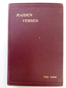 Warrnambool and District Historical Society Inc.
Book, Maiden Verses, 1901
This book contains verses written by Tilly Aston. Matilda Ann (Tilly) Aston was a blind writer and teacher who was born in Carisbrook, Victoria in 1873. She became totally blind at the age of seven. She learned Braille and gained her Matriculation Certificate, spending a short time at Melbourne University. She helped to establish the Victorian Association of Braille Writers and to found the Association for the Advancement of the Blind. She was the first Secretary and later President of the latter association. She was appointed the Head of the School for the Blind in Melbourne and retired from this position in 1925. She published several books of verse and prose. There is a Parliamentary electorate in Victoria called Aston. This book is of considerable interest because the author, Tilly Aston, has an important place in Australian literature. The book, ‘Maiden Verses’ has a local Warrnambool connection as it contains a poem written about Warrnambool, a town which Tilly Aston visited on occasions.This is a hard cover book of 146 pages. It is a book of poems written by Tilly Aston. The cover is dark red with the printing on the spine and on the cover in gold lettering. There is at least one page at the front of the book torn out. There is a receipt for the purchase of the book pasted on to the inside of the front cover. The date of the receipt made out to ‘John F. Watts’ is for three shillings and sixpence (1900). The book is bound with glue and string.Signature on the first page: ‘John F. Watts, Nov. 18th 1900’ (or maybe ‘1901’)tilly aston, australian literature, history of warrnambool -
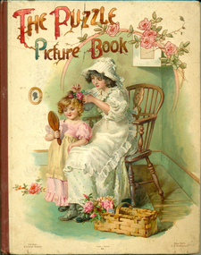 Warrnambool and District Historical Society Inc.
Book - Book: The Puzzle Picture Book, Ernest Nister, The Puzzle Picture Book, 1900
The book, awarded to Ethel Henderson in 1903, from Christ Church, Warrnambool is an example of a Sunday School prize given to children attending Sunday School at the time. Christ Church Anglican Church was one of the early churches in Warrnambool.The Puzzle Picture Book is a rare 'movable' children's book from 1900. It contains 6 chromolithic dissolving scenes (also called slats/transformations). It is unusual due to its educational content. It was published by Ernest Nister in London, E F Dutton & Co in USA and is also thought to have been published in German under the title 'Ueberraschungen Aller Art'. [source: The Little Book Store]Child's picture book with full colour cover depicting a mother dressed in long white spotted dress, white apron, white bonnett and black button-up shoes, sitting on a wooden armchair while dressing a young girl's hair with pink flowers. The girl is dressed in a pink frock with puffed sleeves and frill around the hem, and cream apron. She is looking in a brown wooden-backed hand mirror. A woven straw basket with pink roses sits on the floor. A framed silhouette picture is on the wall. The title is in a display typeface mimicking rose stems; a swag of pink roses decorates the top right hand corner. The publishers' names are printed on the bottom left and right hand corners at the bottom, and the printer in the centre. The inside cover has a book plate. The title page shows two boys arguing over the book. The verses are by Clifton Bingham, the pen and ink illustrations by Hilda K. Robinson. The story has a monochrome page with rhymes opposite a colour page with cut-out boxes showing four small pictures, each with a question. By pulling the tab at the bottom of the page the answer to the questions is revealed. There are six chromolithic 'dissolving scenes'.Book plate: Christ Church. Sunday School, Warrnambool. 1st Prize Girls Class II. Awarded to Ethel Henderson. S M George Vicar. Warrnambool, May 1903children's picture books, ethel henderson, children's picture books, puzzle books, christ church anglican church, sunday school prizes, ernest nister london, warrnambool, ethel henderson, e f dutton & co new york -
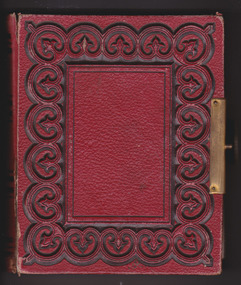 Warrnambool and District Historical Society Inc.
Album - Photo Album, Late 19th century
This album contains photos done on photographic paper while others are on exposed metal. Some are named, among them a Thomas or Edward Wickham, Fred Giles, Mrs. F Giles, Mary Humphrey Wickham, Jack Giles, Eliza Hornsby. Some of the photographs have been taken by Warrnambool photographers including Daniel Clarke. This album shows two different methods of photography which existed in the mid to late 19th century. With a number of the photos named it would suggest that there is some family connection between them which provokes an interest from a genealogical point of view. Red leather cover with circular pattern with black edging which sits around rectangle on front and back. Brass metal clasp. Pages are edged in gold. First pages has photo of woman leaning on back of couch and last page has cut out coloured picture of three children with garlands of flowers.Stamp inside front cover, Hider, Charles Liebig St, Warrnambool.warrnambool, photo album warrnambool, giles family album, 19th century album, giles, wickham, hornsby, daniel clarke -
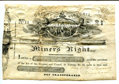 Orbost & District Historical Society
Certificate, September 1867
Following a Royal Commission in 1855, the Gold License was changed to the Miner’s Right, which reduced the fee and required annual payment, rather than monthly or quarterly.The fourth Goldfields Act, passed in early 1858, gave increased privileges to holders of Miner's Rights. These included the right to make residential claims, allowing the cutting of timber on claims and giving the right to build races and dams on any crown lands for mining purposes. This certificate is in the name of Samuel Richardson who brought it to Orbost.This item is of historical significance as it is associated with positive outcomes for gold miners brought about by the Eureka Stockade rebellion and its subsequent democrat changes. It is also associated with the Richardsonfamily who were early settlers in Orbost.A certificate for a miner's right printed on paper. It cost one pound. It was Not Transferable. Details have been filled out in ink. At the top of the licence is an elaborate etching, under the heading 'Colony of Victoria'. Inside a shield is a young woman, crowned, seated, with shipping in the background. oO her left is a miner with hat presenting her with a gold nugget while on her right, a farmer presents grain to her. Mottoes include 'Honi Soit Que Mal Y Pense'; 'Dieu et Mon Droit' and 'Advance Australia' There are handwritten notes in faded ink on the back.miner's right, colony of victoria, samuel richardson, no 14, government act -
 Orbost & District Historical Society
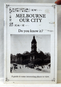
brochure, A.E .Keating (Printing) Pty Ltd, Melbourne Our City, 1980 - 1990's
This is a useful reference tool.A stapled soft covered 26 pp brochure. The cover is white and inside a black frame is the title, "Melbourne Our City. Do You know It?' in black print with a black/white photograph of the city in the early 1900's. At the foot is " A guide to some Interesting places to view". It contains b/w illustrations and the last page folds out. -
 Orbost & District Historical Society
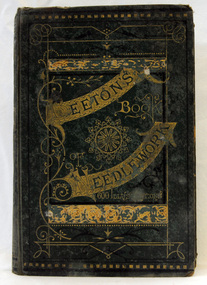
book, J.Ogden and Co, Beeton's Book of Needlework, 1870
Isabella Mary Beeton (née Mayson; 14 March 1836 – 6 February 1865), also known as Mrs Beeton, was an English journalist, editor and writer.In the 19th century, the craft of embroidery became a pastime for women. Needlework creations were crafted to be displayed in the home.This book is an example of a popular book of ithat time.A hard back book with a dark green fabric cover. The title is in gold print -"Beeton's Book of Needlework" inside an ornate gold border. It contains descriptions and instructions for tatting patterns, crochet patterns, knitting patterns, netting patterns, embroidery patterns and point lace patterns. There are six hundred illustrations / engravings. some of the patterns are fold-out.inside cover - "Special first prize to Catherine J. Horne by Mrs William for Needlework" Tarang State Schoolbeeton-isabella needlework-knitting-lacework