Showing 311 items
matching bass strait
-
 Lakes Entrance Regional Historical Society (operating as Lakes Entrance History Centre & Museum)
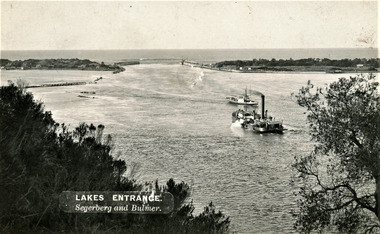
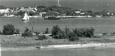
Photograph, Segerberg and Bulmer, 1910 c
... of the entrance to the Gippsland Lakes from Bass Strait. Pioneer dredge... to the Gippsland Lakes from Bass Strait. Pioneer dredge in centre ...Also enlargement 17 x 23 cmBlack and white photograph showing view from Jemmys Point of the entrance to the Gippsland Lakes from Bass Strait. Pioneer dredge in centre foreground, and steamer JCD. Cottages and works buildings including Rocket shed on eastern dunes, Schnapper Cottage on far right western dune. Rock groynes and tip of Bullock Island centre left. Vegetation in foreground. Lakes Entrance VictoriaLAKES ENTRANCE Segerberg and Bulmerships and shipping, topography, jetties, houses -
 Lakes Entrance Regional Historical Society (operating as Lakes Entrance History Centre & Museum)
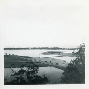
Photograph, Fraser Ian, 1950c
... and bridge, entrance to Bass Strait and sand dunes along Cunninghame... of Bullock Island and bridge, entrance to Bass Strait and sand dunes ...Black and white photograph of Bullock Island, showing Prince's Highway from North Arm bridge, east end of Bullock Island and bridge, entrance to Bass Strait and sand dunes along Cunninghame Arm. Western end of Bullock Island bridge raised to allow small boats access to North Arm and Cunninghame Arm, became known as Humpy Bridge. Lakes Entrance Victoriafishing industry, islands, waterways, ships and shipping, topography -
 Orbost & District Historical Society
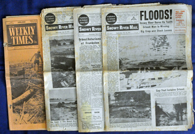
newspapers, February, March 1971
... plain. Records say that "The brown floodwater stain in Bass... stain in Bass Strait could be seen from passing airliners ...The 1971 flood was the the worst flood on record. At Jarrahmond it was at least 11 metres and up to one and a half kilometres wide on the flats causing enormous damage to the flood plain. Records say that "The brown floodwater stain in Bass Strait could be seen from passing airliners." Considerable damage was done to railway infrastructure, roads and farms. More information from the APRIL, 2008 newsletter by John Phillips. (see orbosthistory.com.au) These newspapers are contemporary records of a significant local event.Four newspapers relating to the floods in 1971. They contain news articles and photographs of the floods in Orbost in early 1971. 2556.1 is the Weekly Times dated 3.3.1971 and has an orange cover. 2556.2 is a Snowy River Mail dated 17.2.1971. 2556.3 is a Snowy River Mail dated 10.2.1971. 2556.4 is a Snowy River Mail dated 3.3.1971.floods-orbost-1971 snowy-river-mail weekly-times newspapers -
 Orbost & District Historical Society
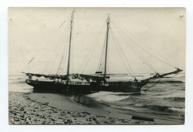
black and white photograph
... joining the Gippsland Lakes to Bass Strait – Ninety Mile Beach... at the Natural Entrance joining the Gippsland Lakes to Bass Strait ...The “Glengarry” beached at Marlo The schooner Glengarry was a well-known trader on the Gippsland coast and had been stranded on a number of previous occasions including at the Natural Entrance joining the Gippsland Lakes to Bass Strait – Ninety Mile Beach, Lakes Entrance, c 1877 . In May 1898, the vessel struck a submerged object while crossing the Snowy River bar at Marlo and was beached, eventually becoming a total loss. Until t he railway came to East Gippsland goods were shipped from Marlo to Melbourne. This is a pictorial record of a well-known trading ship involved in that river transport.Three copies of a black / white photograph of the Schooner Glengarry wrecked in 1891 at the Snowy River entrance at Marlo.schooner-glengarry shipping transport-orbost -
 Churchill Island Heritage Farm
Photograph of HMS Lady Nelson Replica, >1986
... the coast of Australia. The initial exploration of the Bass Strait... of the Bass Strait by Commander James Grant has long been believed ...The HMS Lady Nelson was commissioned in 1799 to survey the coast of Australia. The initial exploration of the Bass Strait by Commander James Grant has long been believed to be the marker of the discovery of Churchill Island by Europeans and there have been tales that Commander Grant was the first European to set foot on the Island. While there is little proof of this, the photograph still serves to contextualise this event and show what the Lady Nelson looked like.Black and white photograph showing a ship with pennants and no sails. Ship is on the land, displayed by the side of the road. There is a series of low slung buildings in the background. Through preliminary research, it appears this is a replica model of the HMS Lady Nelson built in 1986 that is located at the Lady Nelson Visitor and Discovery Centre in Mt Gambier.Catalogue number in pencil on reverse. 'HMS Nelson' written on reverse in penchurchill island, lady nelson, ship, photograph -
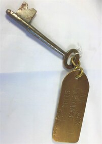 Queenscliffe Maritime Museum
Functional object - Key
... off Phillip Island, Bass Strait, Australia. Read more... Pyramid Rock off Phillip Island, Bass Strait, Australia. Read more ...The SS George Kermode was an Australian Steam Bucket Dredger of 1,380 tons built in 1914 by Fleming & Ferguson, Paisley. In 1917 she was acquired by the Australian Government. In 1941 she was acquired by the Melbourne Harbour Trust Comm. and renamed Geo. Kermode. On the 1st April 1976 she was scuttled near Pyramid Rock off Phillip Island, Bass Strait, Australia. Read more at wrecksite: https://www.wrecksite.eu/wreck.aspx?31789Key to main deck entrance with brass tag [starboard side of G. Kermode]Main deck entrance stbd G. Kermodekey, dredger, ss george kermode -
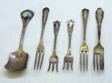 Orbost & District Historical Society
cutlery, first half 20th century
... to Melbourne route across Bass Strait. The ship continued operating... to Melbourne route across Bass Strait. The ship continued operating ...MS Princess of Tasmania was an Australian-built roll-on/roll-off passenger ship, built by the State Dockyard in Newcastle, New South Wales for the Australian National Line. Laid down on 15 November 1957, she was launched on 15 December 1958. The Princess of Tasmania sailed on her maiden voyage on 23 September 1959. On entering service, she was used on the Devonport to Melbourne route across Bass Strait. The ship continued operating until 1972, Five silver-plated forks and one spoon. The sugar spoon is a souvenir of the Princess of Tasmania. 1590.2 and .5 are narrow forks. 1590.3 and .4 have splayed tines. 1590.6 is a cake fork.On back of spoon : EP&NS *1 Various marks on backs of forks with EP&NScutlery silver-plated princess-of-tasmania -
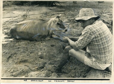 Orbost & District Historical Society
black and white photograph, 11 February 1971
... that "The brown floodwater stain in Bass Strait could be seen from passing... floodwater stain in Bass Strait could be seen from passing airliners ...This photograph was taken during the 1971 floods at Orbost. The 1971 flood was the the worst flood on record. At Jarrahmond it was at least 11 metres and up to one and a half kilometres wide on the flats causing enormous damage to the flood plain. Records say that "The brown floodwater stain in Bass Strait could be seen from passing airliners." Considerable damage was done to railway infrastructure, roads and farms. More information from the APRIL, 2008 newsletter by John Phillips. (see orbosthistory.com.au)This is a contemporary pictorial record of a significant local event.A large black / white photograph of a man, dressed in shorts and a checked shirt, sitting on a fence post surrounded by mud. He is holding on to the leg of a cow which is stuck in the mud.on front - "Mr Harrison on Tracey's Dairy" on back - " Herald 11 Feb 1971"floods-orbost-1971 tracey-dairy natural-disaster-flood -
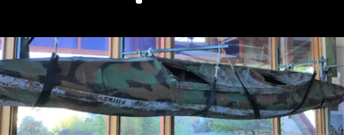 Queenscliffe Maritime Museum
Vehicle - Kayak, Commandos
... connecting Port Phillip Bay and Bass Strait. This is the only... connecting Port Phillip Bay and Bass Strait. This is the only ...The remarkable story when 74 soldiers fought in vain to save the lives of their mates off Portsea as 3 soldiers died. Tragically, Privates Roger Wood and Edward Meyer, and Warrant Officer George "Taffy" Drakopoulos, died. Please Note: "The Rip" is also known as "The Heads", which is a dangerous stretch of water connecting Port Phillip Bay and Bass Strait. This is the only entrance for all shipping into Port Phillip Bay and to and from the Port of Melbourne, Victoria, Australia.Kayak of a similar type as those used during the ill-fated army exercise with loss of life in the rip.rip disaster, commandos, kayak, military history - army -
 Port Melbourne Historical & Preservation Society
Photograph - SS Nairana, Feb 1951
... requisitioned for war service in WW2, was used as a Bass Strait ferry... requisitioned for war service in WW2, was used as a Bass Strait ferry ...The SS Nairana was launched 1915 by William Denny & Brothers in Dumbarton Scotland the 3,402 ton steamer was requisitioned by the Royal Navy and served during WW1. In 1922 she was transferred to Tasmanian Steamers and, apart from again being requisitioned for war service in WW2, was used as a Bass Strait ferry until 1948. The Nairana was blown ashore onto Port Melbourne beach during a severe gale on 19 February 1951. After salvage what remained of the wreck was blown up in 1954. B & W photograph of SS Nairana with lifeboats joining shipwreck to Port Melbourne beach.transport - shipping, ss nairana -
Port Melbourne Historical & Preservation Society
Photograph - SS Nairana, C.1951
... requisitioned for war service in WW2, was used as a Bass Strait ferry... service in WW2, was used as a Bass Strait ferry until 1948 ...The SS Nairana was launched 1915 by William Denny & Brothers in Dumbarton Scotland the 3,402 ton steamer was requisitioned by the Royal Navy and served during WW1. In 1922 she was transferred to Tasmanian Steamers and, apart from again being requisitioned for war service in WW2, was used as a Bass Strait ferry until 1948. The Nairana was blown ashore onto Port Melbourne beach during a severe gale on 19 February 1951. After salvage what remained of the wreck was blown up in 1954. B & W aerial photograph of SS Nairana and Port Melbourne foreshoress nairana, transport - shipping -
Port Melbourne Historical & Preservation Society
Photograph - SS Nairana, C.1951
... requisitioned for war service in WW2, was used as a Bass Strait ferry... in WW2, was used as a Bass Strait ferry until 1948. The Nairana ...The SS Nairana was launched 1915 by William Denny & Brothers in Dumbarton Scotland the 3,402 ton steamer was requisitioned by the Royal Navy and served during WW1. In 1922 she was transferred to Tasmanian Steamers and, apart from again being requisitioned for war service in WW2, was used as a Bass Strait ferry until 1948. The Nairana was blown ashore onto Port Melbourne beach during a severe gale on 19 February 1951. After salvage what remained of the wreck was blown up in 1954. B & W aerial photograph of SS Nairana and Port Melbourne foreshore. Ship's outline can be seen on far right side of photograp.ss nairana, transport - shipping -
 Lakes Entrance Regional Historical Society (operating as Lakes Entrance History Centre & Museum)
Photograph, 1920c
... from the ocean - Bass Strait. View shows flagstaff on top... from the ocean - Bass Strait. View shows flagstaff on top ...Copied from copy in J Whadcoat collectionBlack and white photograph showing P W D cottage on left and other Works buildings on dune at the entrance to Gippsland Lakes from the ocean - Bass Strait. View shows flagstaff on top of dune and flagstaff jetty in lake - Cunninghame Arm. Small sailing boat on left and other small craft on shoreline. Section of Bullock Island with vegetation, one telegraph pole and one dead tree on island. Shoreline of North arm in foreground. Lakes Entrance Victoriajetties, township, waterfront, accommodation, waterways, ships and shipping -
 Lakes Entrance Regional Historical Society (operating as Lakes Entrance History Centre & Museum)
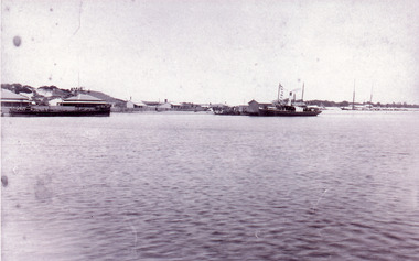
Photograph, 1890c
... and boats at the entrance to Gippsland Lakes from ocean - Bass... from ocean - Bass Strait. Photo shows two PWD houses on left ...Three copies -Sepia photograph showing dunes, houses and Works buildings and boats at the entrance to Gippsland Lakes from ocean - Bass Strait. Photo shows two PWD houses on left and small school building, plus other Works buildings. Flagstaff on dune above houses. Large barge on left in front of houses. Large passenger steamer at New Works wharf with people waiting, has flags and bunting, two masted ketch on right of rock groynes. Lakes Entrance Victoriajetties, township, boats and boating, topography -
 Orbost & District Historical Society
black and white photograph, February 1971
... that "The brown floodwater stain in Bass Strait could be seen from passing... floodwater stain in Bass Strait could be seen from passing airliners ...This photograph was taken near the Snowy River Bridge on the the old Princes Highway in Orbost, near the caravan park. The 1971 flood was the the worst flood on record. At Jarrahmond it was at least 11 metres and up to one and a half kilometres wide on the flats causing enormous damage to the flood plain. Records say that "The brown floodwater stain in Bass Strait could be seen from passing airliners." Considerable damage was done to railway infrastructure, roads and farms. More information from the APRIL, 2008 newsletter by John Phillips. (see orbosthistory.com.au)This is pictorial evidence of a significant local event. Floods have been an integral part of Orbost's history for hundreds of years.A black / white photograph of debris, fallen power lines, a tree across the highway and floodwaters across the road.on front at bottom - handwritten in upper case print - " 1971 FLOOD PRINCES HIGHWAY NEAR SNOWY BRIDGE"floods-orbost-1971 -
 Orbost & District Historical Society
black and white photograph, February 1971
... in Bass Strait could be seen from passing airliners." Considerable... that "The brown floodwater stain in Bass Strait could be seen from passing ...This photograph is an aerial view of the township of Orbost taken by the Bairnsdale Advertiser newspaper. It was taken from the northern end of the town. The 1971 flood was the the worst flood on record. At Jarrahmond it was at least 11 metres and up to one and a half kilometres wide on the flats causing enormous damage to the flood plain. Records say that "The brown floodwater stain in Bass Strait could be seen from passing airliners." Considerable damage was done to railway infrastructure, roads and farms. More information from the APRIL, 2008 newsletter by John Phillips. (see orbosthistory.com.au)This is a pictorial record of a significant event in the history of Orbost,A black / white aerial photograph of a township with floodwaters in the background.on back - "Note main current through the lagoon 1971."orbost-floods-1971 bairnsdale-advertiser orbost-township -
 Queenscliffe Maritime Museum
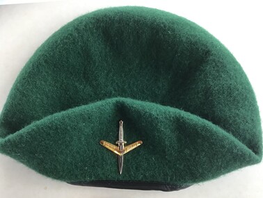
Uniform - Beret
... seas in Bass Strait.... and more than 70 others were rescued from huge seas in Bass Strait ...On the evening of February 17, 1960, 74 peacetime commandos in army boats set off on a training exercise from Point Lonsdale to Point Nepean, simulating a raid. The weather was calm at Point Lonsdale on a midweek evening 50 years ago, but 50 years ago weather forecasts were not yet reliable. By nightfall a massive storm came through and all hell broke loose. Soon, three young Victorians were dead and more than 70 others were rescued from huge seas in Bass Strait.Green commando beret similar to ones worn by commandos involved in Rip Disaster of 1960Commando beret (green) with unit insigniaUnit insignia: "Strike Swiftly"commandos, beret -
 Queenscliffe Maritime Museum
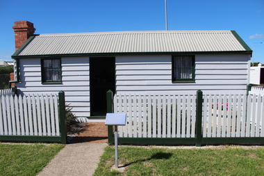
Functional object - Fishermans Cottage, Built in 1870/1880 for Thomas and Anna Ikin
... in Bass Strait. Salmon, snapper and particularly barracouta led... and the size of catch available to those fishing in Bass Strait. Salmon ...This low-lying northern-most tip of Queenscliff saw its physical origins in 1863 with allotments let to a burgeoning fishing community previously accommodated on the site of the current railway station and whose construction in 1879 necessitated eviction. Among this community, Chinese fishermen are thought to be of the first international settlers. The success of the fishermen’s settlement was due in part to commercial trading prospects the railway afforded and the size of catch available to those fishing in Bass Strait. Salmon, snapper and particularly barracouta led to the success of the local industry.Original Fishermans Cottage previously located at Swan Bay end of Bridge Street Queenscliff. Timber - Weatherboardfishermen's cottage, fishermen's flat, queenscliff -
 Orbost & District Historical Society
black and white photographs, 15th February 1971
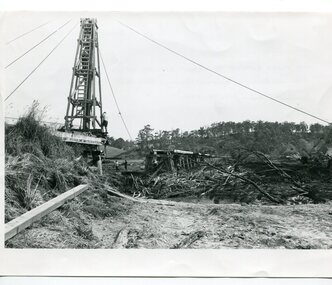
... plain. Records say that "The brown floodwater stain in Bass... that "The brown floodwater stain in Bass Strait could be seen from passing ...The 1971 flood was the the worst flood on record. At Jarrahmond it was at least 11 metres and up to one and a half kilometres wide on the flats causing enormous damage to the flood plain. Records say that "The brown floodwater stain in Bass Strait could be seen from passing airliners." Considerable damage was done to railway infrastructure, roads and farms. More information from the APRIL, 2008 newsletter by John Phillips. (see orbosthistory.com.au) The railway line was destroyed and was not expected to be opened for a fortnight. Orbost was cut off by 50 square miles of Snowy River floodwater. These photographs are pictorial records of the 1971 floods which was a significant event in the history of Orbost. They are also associated with the East Gippsland Railway.Three black / white photographs of flood debris and flood waters near a railway line. 3102.l has a pile driver 3102.2 shows a gap in the viaduct and 3102.3 shows men with a tractor cleaning up the debris,3102.1 - on back - "1971 FLOOD REPAIRS TO ORBOST RAILWAY VIADUCT - 15th February 1971. Donated by Audrey Van Den Berg VRH 3693" 3102.2 - on back - " DAMAGE TO RAILWAY VIADUCT ACCUMULATED DEBRIS" 3102.3 - on back - "DAMAGE TO RAILWAY VIADUCT AT ORBOST. CLEAN UP BEGINS"orbost-flood-1971 orbost-viaduct-flood-damage orbost-railway -
 Orbost & District Historical Society
black and white photograph, February, 1971
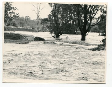
... floodwater stain in Bass Strait could be seen from passing airliners... stain in Bass Strait could be seen from passing airliners ...This photograph shows the floodwaters during the 1971 flood at Orbost. The two mahogany trees in the photograph stopped the Snowy River from changing its course. The 1971 flood was the the worst flood on record. At Jarrahmond it was at least 11 metres and up to one and a half kilometres wide on the flats causing enormous damage to the flood plain. Records say that "The brown floodwater stain in Bass Strait could be seen from passing airliners." Considerable damage was done to railway infrastructure, roads and farms. More information from the APRIL, 2008 newsletter by John Phillips. (see orbosthistory.com.au)This is a pictorial record of a significant event in the history of floods in Orbost.A black / white photograph of raging floodwaters at the bottom of the Orbost township.orbost-flood-1971 -
 Flagstaff Hill Maritime Museum and Village
Functional object - Ship's Wheel, ca 19th century
... at King Island, which is in Bass Strait, northwest of Tasmania... at King Island, which is in Bass Strait, northwest of Tasmania ...This wooden ship's wheel originally had eight spokes but four are no longer in their sockets. One of the spokes has been shaped. Both sides of the wheel have a brass cap over the centre of the hub, covering the wooden hub. The wood is split and cracked, and parts of it have small holes, a sign of being affected by the sea worm. Thick encrustations are on parts of the wheel, showing that it has been on the sea bed for quite some time. The donor is a Warrnambool resident. Years ago he was cray fishing at King Island, which is in Bass Strait, northwest of Tasmania. His craypot got stuck in a reef so a diver helped him by retrieving the craypot for him. While the diver was underwater he also stumbled across the ship's wheel, which he gave to the donor. The Bass Strait is a very narrow route that was difficult and dangerous to navigate in the early 19th century, before good maps, communications and lighthouses were installed. The area, including King Island, is the graveyard of many ships that almost made it to their destination of Melbourne along Australia's treacherous coastline. Around King Island alone, many ships and lives were lost. There is no information about the history of this ship's wheel. Its condition shows that the item has been under the water for a long time. However, there is no evidence that it came from a shipwreck. It could even have been an old ship that could have been scuttled or destroyed as it was no longer useful. The wheel is significant as a sign of shipping around King Island. It is part of the island's history, and of maritime history. It is an example of an item manufactured by hand.Ship's wheel; segment of a wooden ship's wheel. It once had eight spokes but only portions of four spokes remain. The outer centres of the hub and the reinforcing bands around the hub are brass. The wheel is heavily encrusted in parts. It was recovered from an unknown shipwreck in the waters of King Island.great ocean road, warrnambool, shipwreck artefact, artefact, ship's wheel, ship's wheel segment, portion of a ship's wheel, flagstaff hill, maritime museum, maritime village, flagstaff hill divers, marine technology, navigation, steering wheel, eight spoke wheel, king island, craypot, diver -
 South Gippsland Shire Council
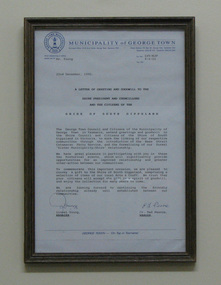
Document, Framed, Letter of Greeting & Goodwill, 22/12/1990
... of the Bass Strait Catamaran Ferry Services dated 22 December 1990... of the Bass Strait Catamaran Ferry Services dated 22 December 1990 ...Framed letter of greeting and goodwill from the Municipality of Georgetown, Tasmania to the South Gippsland Shire to mark the linking of the communities through the introduction of the Bass Strait Catamaran Ferry Services dated 22 December 1990. Signed by Lionel Young, Manager and Cr. Ted Pearce, Warden. George Town Council logo upper left corner. Brown timber frame. Note: Item approved for deaccession August 2023. SGSC will now follow deaccession procedures as outlined in the Arts and Civic Memorabilia Collection Policy - https://www.southgippsland.vic.gov.au/downloads/file/2763/arts_and_artefacts_collection_policy_c69. -
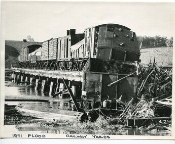 Orbost & District Historical Society
black and white photograph, February 1971
... plain. Records say that "The brown floodwater stain in Bass... stain in Bass Strait could be seen from passing airliners ...The 1971 flood was the the worst flood on record. At Jarrahmond it was at least 11 metres and up to one and a half kilometres wide on the flats causing enormous damage to the flood plain. Records say that "The brown floodwater stain in Bass Strait could be seen from passing airliners." Considerable damage was done to railway infrastructure, roads and farms. More information from the APRIL, 2008 newsletter by John Phillips. (see orbosthistory.com.au) The railway line was destroyed and was not expected to be opened for a fortnight. Orbost was cut off by 50 square miles of Snowy River floodwater. This train was being shunted across the viaduct when waters smashed through washing away several trucks sending the crew running for their lives.This is pictorial evidence of a significant local event. It is connected to the history of the railway in East Gippsland.A large black / white photograph of flooded railway yards with a train engine stranded on a small section of track surrounded by water and debris.on front - "1971 Flood, Railway Yards"floods-1971-orbost orbost-railway natural-disasters-orbost -
Port Melbourne Historical & Preservation Society
Film - Video Recording - Digital, Bruce Gooley, Men and Ships Driven by the Wind, 27 Sep 2022
... yachts in Port Phillip Bay, and Bass Strait, and has crewed... yachts in Port Phillip Bay, and Bass Strait, and has crewed ...Bruce GOOLEY is a graduate of Melbourne University and a researcher, presenter and self-published author with a special interest in maritime history. He is a volunteer tutor at the Hawthorn University of the Third Age (U3A). He has presented over 120 one and a half hour illustrated maritime history talks there, and has also presented to Provis and Historical Societies, and has documented these talks in book format. Bruce was a member of the Mornington Yacht Club for more than 50 years and owned and raced yachts in Port Phillip Bay, and Bass Strait, and has crewed on yachts racing to Vanuatu and around the State of Hawaii and cruising in the Beagle Channel. He is also a member of the Melbourne Maritime Heritage Network and he has presented several papers to them.Digital video recording of PMHPS meeting held on 27 September 2022. Bruce GOOLEY presents "Men and Ships Driven by the Wind"bruce gooley, transport - shipping -
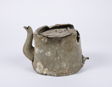 Queenscliffe Maritime Museum
Domestic object - Teapot
... In 1940, German minefields were laid in east and west Bass... Goorangai In 1940, German minefields were laid in east and west Bass ...In 1940, German minefields were laid in east and west Bass Strait which quickly claimed merchant ships Cambridge (British) and the City of Rayville (American). HMAS Goorangai had finished mine sweeping duties and after resupply was crossing from Queenscliff to Point Nepean to seek better anchorage due to impending bad weather. At around 20:30 on the 20th of November 1940 the 10,400-ton MV Duntroon was transiting the South Channel on her way to Sydney from Perth via Melbourne carrying 65 passengers and general and perishable cargo. It struck HMAS Goorangai forward of the funnel on the port side and cut her in two. At about 20:45 HMAS Goorangai sank in less than a minute resulting in the loss of her whole ship’s company, a complement of 24 officers and sailors.HMAS Goorangai was the first Royal Australian Navy (RAN) ship lost in WWII, the first RAN surface ship lost in wartime, and the first RAN surface ship lost with all hands. A memorial cairn was erected at Queenscliff in 1981 and a service of commemoration is held there every year.A severely damaged and corroded aluminium teapot recovered from the wreck of HMAS Goorangaihmas goorangai, wwii, collision at sea -
 Eltham District Historical Society Inc
Photograph, George Coop, Fire damaged Wilhelmsen Line ship Tomar at Victoria Dock, Melbourne, Jan. 1968
... , Australia. Whilst crossing the Bass Strait near Robe, South.... Whilst crossing the Bass Strait near Robe, South Australia ...When George Coop and wife Helen following several years teaching in Canada, they bought a passage aboard the Wilhelmsen line cargo ship, Tomar departing Oslo, Norway for Melbourne, Australia. Whilst crossing the Bass Strait near Robe, South Australia, a generator in the engine room caught fire threatening the ship's fuel oil tanks, forcing the Captain to order the 43 crew and 8 passengers to abandon ship. They spent many hours in a lifeboat before being rescued. This photo was taken when the ship was brought up to Victoria Docks (No. 26 South Wharf) where George and other passengers were allowed to retrieve their luggage. The ship was then taken to Kaohsiung, Taiwan for scrapping. See also https://www.shipsnostalgia.com/media/tomar.450919/ http://www.shipspotting.com/gallery/photo.php?lid=2726028 http://www.shipspotting.com/gallery/photo.php?lid=2961287 https://www.flickr.com/photos/wheelhouseno/8131145299Digital TIFF file Scan of 35mm Kodak Plus-X Pan black and white negative transparencygeorge coop collection, tomar (ship), victoria docks, wilhelmsen line -
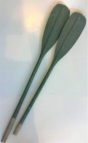 Queenscliffe Maritime Museum
Functional object - Paddles
... as their vehicle sank. Eight of the commandos were rescued in Bass Strait... sank. Eight of the commandos were rescued in Bass Strait after ...In 1960 seventy-four commandos from 2 Commando Company left Point Lonsdale at 6pm on February 17 to cross The Rip in an exercise raid on the Portsea officer school. Shortly after departing, a strong tide caught the raiding party and pushed them out to sea through The Rip, where 10-metre waves capsized many of the kayaks and amphibious vehicles. Many of the men were picked up by larger rescue boats, only to be overturned once again in the heavy seas. Warrant Officer George Drakopolous and the driver of his amphibious DUKW, Private Eddie Meyer, both drowned as their vehicle sank. Eight of the commandos were rescued in Bass Strait after being picked up by an Italian ship, the Toscana. Commando Roger Wood helped others board the Toscana safely but was washed off a rope ladder by a monster wave and into the sea. His body was never found. It remains one of Australia's least-known peacetime military tragedies.One of the later disasters around the Rip between Points Nepean and Lonsdale. The 'Queenscliffe' lifeboat turned out to search for survivors without success Paddles from a Mk3 foldaboat used in ill fated commando training exercise in 1960the rip disaster, kayaks, oars -
 Flagstaff Hill Maritime Museum and Village
Bracket, On or before 1889, when the Newfield was built
... expecting to run through the western entrance of Bass Strait... through the western entrance of Bass Strait, but instead, at about ...This bracket was recovered from the wreck of the Newfield. The barque Newfield left Liverpool on 1st June 1892 with a cargo of 1850 tons of fine rock salt for Brisbane. About six weeks later the ship ran into very heavy weather approaching the Australian coast. On 28th August at about 9pm her master, Captain George Scott, observed between the heavy squalls the Cape Otway light on the mainland of Victoria, but due apparently to a navigational error (the chronometers were incorrect), he mistook it for Cape Wickham on King Island, some 40 miles south. He altered course to the north expecting to run through the western entrance of Bass Strait, but instead, at about 1:30am, the ship ran aground about about 100 yards from shore, one mile east of Curdies River. The vessel struck heavily three times before grounding on an inner shoal with six feet of water in the holds. The Newfield remained upright on the reef with sails set for a considerable time as the wind slowly ripped the canvas to shreds and the sea battered the hull to pieces. Seventeen men survived the shipwreck but the captain and eight of his crew perishedFlagstaff Hill’s collection of artefacts from the Newfield is significant for its association with the shipwreck Newfield, which is listed on the Victorian Heritage Registry. The collection is significant because of the relationship between the objects. The Newfield collection is archaeologically significant as the remains of an international cargo ship. The Newfield collection is historically significant for representing aspects of Victoria’s shipping history and its association with the shipwreck.‘L’ bracket, copper, 3 holes on one side, 2 holes on the other1893, shipwrecks, shipwrecked coast, flagstaff hill, flagstaff hill maritime museum, maritime museum, shipwrecked artefact, flagstaff hill maritime village, shipwreck coast, warrnambool, newfield, 1892, 28 august 1892, port campbell, nineteenth century, victorian shipwrecks, barque, norma bracken, peterborough, 29 august 1892, peter ronald, curdies river, bracket -
 Flagstaff Hill Maritime Museum and Village
Functional object - Porthole, Before June 1892, when the Newfield sailed for Brisbane
... of Bass Strait, but instead, at about 1:30am, the ship ran aground... through the western entrance of Bass Strait, but instead, at about ...This porthole frame was recovered from the wreck of the Newfield. The barque Newfield left Liverpool on 1st June 1892 with a cargo of 1850 tons of fine rock salt for Brisbane. About six weeks later the ship ran into very heavy weather approaching the Australian coast. On 28th August at about 9pm her master, Captain George Scott, observed between the heavy squalls the Cape Otway light on the mainland of Victoria, but due apparently to a navigational error (the chronometers were incorrect), he mistook it for Cape Wickham on King Island, some 40 miles south. He altered course to the north expecting to run through the western entrance of Bass Strait, but instead, at about 1:30am, the ship ran aground about about 100 yards from shore, one mile east of Curdies River. The vessel struck heavily three times before grounding on an inner shoal with six feet of water in the holds. The Newfield remained upright on the reef with sails set for a considerable time as the wind slowly ripped the canvas to shreds and the sea battered the hull to pieces. Seventeen men survived the shipwreck but the captain and eight of his crew perished.Flagstaff Hill’s collection of artefacts from the Newfield is significant for its association with the shipwreck Newfield, which is listed on the Victorian Heritage Registry. The collection is significant because of the relationship between the objects. The Newfield collection is archaeologically significant as the remains of an international cargo ship. The Newfield collection is historically significant for representing aspects of Victoria’s shipping history and its association with the shipwreck.A porthole frame from the wreck of the Newfield. The porthole and glass are missing. It is encrusted, cracked and eroded. There are 8 retaining bolt holes with the remnants of 7 bolts remaining. On the inside are the remains of the hinge flange and the two release screws. Restored, good condition.warrnambool, shipwrecked coast, flagstaff hill, flagstaff hill maritime museum, maritime museum, shipwreck coast, flagstaff hill maritime village, shipwrecked artefact, 1892, 1893, 28 august 1892, 29 august 1892, barque, curdie's river, newfield, nineteenth century, peter ronald, peterborough, port campbell, porthole, porthole frame, shipwrecks, victorian shipwrecks