Showing 486 items
matching kilometres
-
 Warrnambool and District Historical Society Inc.
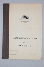
Booklet, Warrnambool's Case for a university, 1961
The information in this booklet was prepared by a University Investigation Committee formed in Warrnambool in 1961 to present the case for the establishment of a university in the Warrnambool area. The chairman of this committee was the Mayor of Warrnambool, Cr P. O’Sullivan and the secretary was W. L. George of Warrnambool. This submission was unsuccessful at the time but campaigning for a university continued. In 1961 Warrnambool Technical School in Timor Street was offering both secondary and tertiary courses in the technical and trades areas and in 1969 the tertiary section of this Technical School became the Warrnambool Institute of Advanced Education. The tertiary section was relocated in 1984 to Sherwood Park, a 94 hectare site on the Princes Highway five kilometres from Warrnambool’s C.B.D. In 1990 Deakin University established a regional campus at Sherwood Park after a merger with the Warrnambool Institute of Advanced Education. This booklet has some historical significance as it contains the information collated on the campaign in Warrnambool and the Western District for a university to be established in the Warrnambool area.This is a soft cover booklet of 48 pages. It has a beige-coloured cover with black printing. The booklet has been bound with brown tape. It has printed information, black and white photographs, a fold-out map, graphs and tables.deakin university, history of warrnambool -
 Warrnambool and District Historical Society Inc.
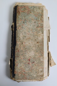
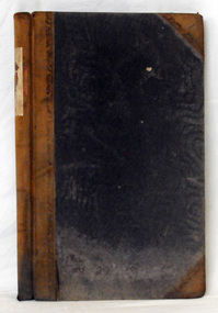
Document - Ledger 1883-1892 repurposed
This ledger was used between 1883 and 1892 to record returns and activities on a farming property including numbers of sheep shorn, chaff cut, fencing contracted and people employed. One envelope within the ledger is addressed to Mrs J Edwards, Morven via Branxholme. The Edwards family, lived on the MORVEN property situated about 11 kilometres west of Branxholme in the Western District of Victoria. This property was sub divided in 1911 into 25 farms. The not fully used ledger has later been repurposed as a recipe book with a collection of newspaper cuttings (1924-1929) inserted and recipes handwritten on 16 pages at the rear. The pages also include some household hints including instructions on how "To prepare sheep skins for mats"This ledger is typical of farming records kept in the period 1883 to 1892. The repurposing of the ledger as a recipe book was a common practice. This ledger has cardboard patterned covers. The paper pages are bound with cotton. Some pages are handwritten in ink. There are loose newspaper cuttings within the ledger as well as two addressed envelopes and a small red recipe booklet.ledger, farming records, recipes, morven, edwards family morven, canvassing department of the australian dried fruits association -
 Bacchus Marsh & District Historical Society
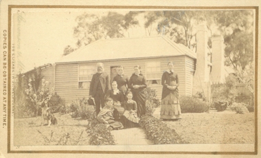
Photograph, Cameron family at Glen Head farm house near Bacchus Marsh 1883
Malcolm Cameron, came from Scotland to Australia with his wife Isabella in 1862. From late 1862 they lived in Bacchus Marsh and remained there for the rest of their lives. After working as a shepherd for some time, Malcolm Cameron was able to acquire land for a farm a few kilometres north west of Bacchus Marsh. The farm was called Glen View but this was later changed to Grand View. It is known to have been a wheat farm. Malcolm Cameron died aged 89 in 1922. His wife died in 1926. Mrs Cameron is presumed to be the woman seated in the photograph and the younger people the Cameron children, Catherine (b.1863), Marion (b.1864)), Mary (b.1867), John (b.1870) and Isabella (b.1872). Small sepia unframed photograph on card with gold border framing photograph. Housed in the album, 'Photographs of Bacchus Marsh and District in 1883 by Stevenson and McNicoll'. The image shows a family group, the Cameron family of Bacchus Marsh, standing and sitting in the garden in front of their farm house. The group comprises four women, a girl, a boy and an elderly man, who is presumed to be Malcolm Cameron. The woman seated in the middle of the group is likely to be Mrs.Cameron. To the left in the picture is a dog. In the background is the weatherboard farm house, a simple construction with two large chimneys and a skillion extension.On the front: Stevenson & McNicoll. Photo. 108 Elizabeth St. Melbourne. COPIES CAN BE OBTAINED AT ANY TIME. On the back: LIGHT & TRUTH inscribed on a banner surmounted by a representation of the rising sun. Copies of this Portrait can be had at any time by sending the Name and Post Office Money Order or Stamps for the amount of order to STEVENSON & McNICOLL LATE BENSON & STEVENSON, Photographers. 108 Elizabeth Street, MELBOURNE. stevenson and mcnicoll 1883 photographs of bacchus marsh and district, farmers, farms, wheat farms, cameron family bacchus marsh -
 Victoria Police Museum
Police Stations (Ararat)
Ararat is a city in south-west Victoria, Australia, about 198 kilometres west of Melbourne, on the Western Highway on the eastern slopes of the Ararat Hills and Cemetery Creek valley between Victoria's Western District and the Wimmera. It is named after Mount Ararat 10 kilometres south-west of the town. A police station opened in Ararat in 1859, though there was a police presence in the area formerly known as Cathcart, Canton Lead and later Mount Ararat. In 1861 staff consisted of 1 Superintendent, 2 Mounted Constables, 1 Sergeant 2nd class, 1 Senior Constable, 8 Constables. The police reserve was on land bounded by Ligar Street, Barkley Street, Ingor Street and High Street. In 1930 the police station was described as a six-room brick dwelling with a slate roof, situated on one quarter acre of land. There was also a bathroom, wash-house, pantry, office, muster room and quarters for a single constable, stables with three stalls, and a lock-up consisting of two six-person cells. Later residences were located at 3 Ligar Street (brick veneer with a tile roof); 32A High Street (brick veneer with tile roof); and 3 Tobin Street (wood with an iron roof). A new, purpose built police station was opened in October 2010 at 77 Barkly Street. The Ararat Police District was reformed into the Wimmera Police District in 1870. Ararat Police Station became part of "R" (Glenelg) District in January 1948 and "M" (Highlands/Wimmera) District from March 1990. A list of police stationed at Ararat from 1903 - 1930 is available from the Victoria Police Museum8 photos comprising: 7 black & white photos 1 colour photopolice stations; ararat police station -
 Orbost & District Historical Society
ledger, 1911-1914
This ledger was used by the Shire of Orbost from 1911 - 1914. It was used to record fees paid for Dairy Registration, Dog Registration and Sheep dipping. At that time dairy farmers were required to register all milking cows. Dogs, too, were to be registered and there were strict laws on sheep dipping. Every sheep-owner was to dip all his sheep immediately after shearing and directly from the shearing-board in every year and also at the time of dipping his sheep dip all his lambs. In case the sheep couldn't be conveniently dipped directly from the shearing board they were to be placed and kept in a securely fenced paddock to be dipped within sixty days after shearing. Sheep-owner who neglected or failed to comply with any of these directives were liable to a penalty of not less than One pound nor more than Twenty pounds. The shire covered an area of 9,347 square kilometres and existed from 1892 until 1994 when it became part of the East Gippsland Shire Council. Orbost was at first included in the Bairnsdale Shire from 1882 and was later part of the Tambo Shire. Because of travelling distances the Croajingalong Shire was created in 1892 (name changed to Orbost Shire 17.2.1893 with James Cameron as the first Shire President. In 1994 it amalgamated to become part of East Gippsland Shire Council. The item was donated to Orbost & District Historical society from P.R.O.V. as a Place of Deposit (POD) item for safe keeping by a local history group or museum. The shire covered an area of 9,347 square kilometres and existed from 1892 until 1994 when it became part of the East Gippsland Shire Council. This item is a record of local council accounting. The Shire of Orbost no longer exists as it was absorbed by the East Gippsland Shire Council.A dark blue, leatherette covered ledger cash book with tan spine, stitched marbled end covers. Records are handwritten in blue and red ink and blue pencil. It contains records of Dairy Registration fees, Dog Registration fees and Sheep Dipping fees.Inside the front cover is a list of contents.ledger orbost-shire-council sheep-dipping dairy-registration accounts -
 Warrnambool and District Historical Society Inc.
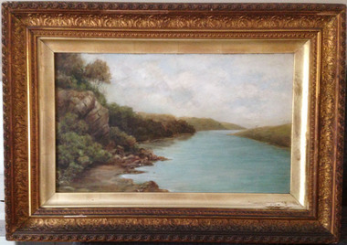
Painting, Hopkins River - Clifton Banks, Early 20th century
Clifton Banks is the name given to a bank on the Hopkins River Estuary, about one kilometre upstream from Proudfoots Boathouse. It is at the foot of the property, Clifton which dates from the 1850s. There are several works of art and photographs depicting Clifton Banks which date from the 19th and early 20th centuries. This oil painting is believed to be the work of Emma McGeorge, the wife of Canon Samuel McGeorge, the Vicar of Christ Church, Warrnambool form 1899 to 1905. It is surmised that Emma McGeorge was encouraged by the artist Mary Norman to take up painting as a pastime or to continue with her art interests. Emma McGeorge may have been a pupil of Samuel Pearce Fuller and Mary Norman. She was successful as an exhibitor and entrant in art exhibitions in Warrnambool in the early 1900s. She died in Warrnambool in 1933. This is a highly significant art work as it has artistic merit and is one of the depictions of Clifton Banks on the Hopkins River and so has historical value. It is an example of the high standard of art work that was being produced, especially by women, in the late 19th and early 20th centuries in Warrnambool. It was bought at an auction sale in Camperdown by Les O’Callaghan in 1997. This is an oil painting, probably by Emma McGeorge, on art board of Clifton Banks on the Hopkins River. It has a gilt wooden frame with multi-tiered highly-ornamented outer frames in a gold colouring. The lower frame is discoloured (perhaps by smoke from a fire place) and there is a small piece of wood missing on the lower frame. All the gilding is slightly discoloured. The back has been sealed with pasted paper and there are old tacks and old wire for hanging the picture. There is a label on the back from W. Hickford, the Warrnambool picture framer and handwritten information on the artist and the artwork by Les O’Callaghan.Front: ‘E.Mc.G.’ Back: ‘W. J. Hickford, Picture Dealer, Framer and Gilder, Liebig Street, Warrnambool, Mounting and Repairing, Old Frames Re-gilt, Oakley Printer’ ‘603’ clifton banks, emma mcgeorge, warrnambool, hopkins river estuary -
 Warrnambool and District Historical Society Inc.
Book, Poems - Australian poetry lovers society, 1952
This book was published in 1952 by the Australian Poetry Lovers’ Society. This group was based in Melbourne and was founded in 1934 by George and Ethel Fielding. In 1973 a member, Harry Hastings Pearce, wrote a history of the society. This 1952 volume contains two poems by Thomas Terrington (born 1897) - ‘Henry Lawson’ and ‘Stella’. Tom Terrington was a well-known local poet and writer from Framlingham. He has been described as a ‘rhymster of flair and skill’. He was a self-taught person with little formal education and he worked at various jobs until he took over the general store at Framlingham in his middle age. He also recorded some of the history of Framlingham, a small settlement about 24 kilometres north east of Warrnambool. The identity of ‘Fred’ in the inscription is not known. This book is of interest because it contains two poems written by Tom Terrington, a local 20th century writer and poet. This is a soft cover book of 50 pages. The cover is green with black printing and an image of two kookaburras on the front cover. The book has poems by 18 writers and a black and white photograph on page 10 of the late George Fielding. The cover is somewhat soiled. The book has been stapled but the staples have been removed. The inscription is handwritten in black ink. ‘To Fred with best wishes from Tom Terrington Framlingham 21.11.52’ tom terrington, history of framlingham -
 Warrnambool and District Historical Society Inc.
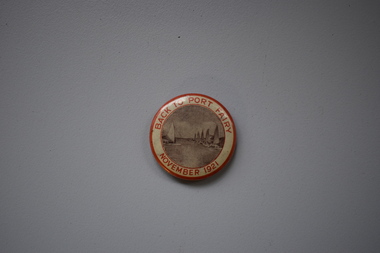
Badge, Back to Port Fairy, 1921
This badge was produced to celebrate a gathering of past and present residents at Port Fairy in 1921, with the event officially called ‘Back to Port Fairy’. Port Fairy is on the Princes Highway, 28 kilometres west of Warrnambool. By 1921 Europeans had settled in Port Fairy for about 85 years, with John Griffiths setting up a whaling station on Griffiths Island in 1836 and James Atkinson establishing the town area in the early 1840s. Atkinson called the town Belfast and it was known by this name until 1887 when the name reverted to Port Fairy. The Back to Port Fairy celebrations in 1921 ran from November 10th to November 19th. A month before, in October 1921, the Glaxo factory, a prominent business in Port Fairy for many years, had been established.This badge is of minor interest as a memento of a celebration at Port Fairy in 1921 and is retained for display purposes.This is a metal badge with red edging, red lettering and a grey-coloured image of boats at the Port Fairy wharf. Back to Port Fairy November 1921port fairy, history of warrnambool, badge, port fairy -
![Photograph - Digital image, Willis Vale [2], 1950c](/media/collectors/4f729f5697f83e03086015b8/items/54fd41442162f10d30bf885f/item-media/54fd41912162f10d30bf8caa/item-fit-380x285.jpg) Greensborough Historical Society
Greensborough Historical SocietyPhotograph - Digital image, Willis Vale [2], 1950c
View of Greensborough in the distance from Willis Vale and surrounding land: House built by Edward Maygar, The flowering Hawthorne Bushes were planted by William Partington. Note the prominent house on upper right where Robert Whatmough lived in the mid 19th century and later sold to Partington family. It was located on the Plenty River across from Partington's Flat. The derelict Willis Vale house was destroyed in 1964 when a fire originating from North Plenty Gorge - Kurrak Road - was lit by two teenage boys and made its way several kilometres down to Partington's Flat Greensborough. In 1946, Alan Partington built the Alwyn Farmhouse in place of the original Robert Whatmough home seen in this photo which became Whatmough Park circa 1976.Home of the Partington familyDigital copy of black and white photograph.willis vale, partington family, maygar family, whatmough -
 Orbost & District Historical Society
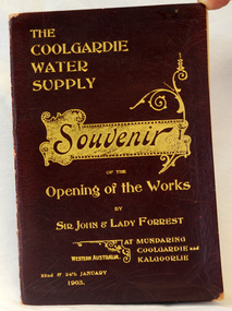
program, The Coolgardie Water Supply, 1903
This program belonged to Dr James Kerr. Conceived by Engineer-in-Chief C.Y. O’Connor and completed in 1903, the Coolgardie Goldfields Water Supply Scheme comprised a reservoir on the Helena River, eight steam-driven pumping stations and 566 kilometres of steel pipeline supplying 23,000 kilolitres of water daily to the arid goldfields of Western Australia. The project was officially opened by Sir John and Lady Forrest in January 1903. "Great pomp and ceremony heralded the arrival of water and the opening of the Scheme. Clean, fresh water could now be easily obtained in some of Australia's harshest country. However, this victory came at a great cost. The stress of the bold project was too much for O’Connor, who, after enduring endless criticism, took his life on 10 March 1902, before the Scheme was completed." - Western Australian Museum : The Coolgardie Goldfields Water Supply Scheme was an ambitious engineering feat because at the time water had never been lifted so high nor pumped so far (about 560 km). The Scheme, which pumps water from the better-watered coastal area, operates to this day. This item is associated with an historic event in the history of opening up arid areas of Australia to settlement. The item is associated with Dr James Kerr, the first doctor to settle in Orbost.A souvenir program from the opening of the works of the Coolgardie Water Supply. It has a maroon cover with gold print. Details include the date and place.coolgardie-water-supply western-australia-goldfields -
 Orbost & District Historical Society
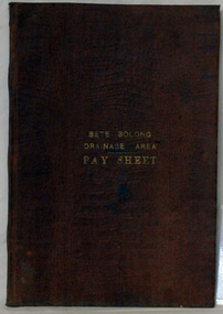
account book, BETE BOLONG DRAINAGE AREA PAY SHEET, 1910 - 1913
This account book was used by the Orbost Shire council to record payments made for work done on the Bete Bolong Drainage Area between 1910 and 1913. The item was donated to Orbost & District Historical society from P.R.O.V. as a Place of Deposit (POD) item for safe keeping by a local history group or museum. The shire covered an area of 9,347 square kilometres and existed from 1892 until 1994 when it became part of the East Gippsland Shire Council. Orbost was at first included in the Bairnsdale Shire from 1882 and was later part of the Tambo Shire. Because of travelling distances the Croajingalong Shire was created in 1892 (name changed to Orbost Shire 17.2.1893 with James Cameron as the first Shire President. In 1994 it amalgamated to become part of East Gippsland Shire Council. This item is a hand-written record of the accounts of the local government. The Orbost Shire Council no longer exists having been absorbed by the East Gippsland Shire Council.A brown leatherette, hard cover book. In gold lettering on the front is "BETE BOLONG DRAINAGE AREA PAY SHEET". It contains records of payments made for work done 1910-1913.In gold lettering on the front is "BETE BOLONG DRAINAGE AREA PAY SHEET".bete-bolong-drainage-area accounts orbost-shire -council -
 Otway Districts Historical Society
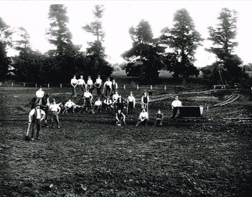
Photograph, Narrow gauge construction camp near Colac, c.1900
Construction of the Colac-Beech Forest railway line commenced in 1900 and the first activities were the work gangs and their camps. About 100 men were engaged in laying and ballasting the track while others formed the earthworks and the building of culverts and bridges. The first camp was established eight kilometres from Colac, the second 12 km south, and the remainder spaced at similar distances as the work progressed. The camps were served by butchers and bakers from Colac that visited them as many times each week to satisfy the mens' requirements. Many of the men had their families with them. They all lived in tents that consisted of a wooden floor around which the canvas cover was built. A calico partition divided the eating and sleeping quarters, and all cooking was done in camp ovens or at open fires.B/W. 158mm x 203mm. Near Colac, a narrow gauge construction camp comprising 21 workmen, a horse, and two tipping trays.construction camp; railways; colac; -
 City of Greater Bendigo - Civic Collection
Souvenir, International Commonwealth Games Committee, Melbourne Commonwealth Games Queens Baton relay, 2006
The Queen's Baton Relay has been the traditional curtain-raiser to the Commonwealth Games since 1958. It symbolises the gathering of people from across the Commonwealth. On 14 March 2005 Her Majesty placed a message in the baton at Buckingham Palace, signalling the start of a journey of almost 180,000 kilometres. The baton's journey to the opening ceremony took exactly one year and one day, arriving at the Melbourne Cricket Ground during the opening ceremony of the Melbourne 2006 Commonwealth Games on 15 March 2006. It was the first baton relay to visit all 71 nations of the Commonwealth. Athletes and non-athletes alike shared the privilege of carrying the baton. In Bendigo two sites were chosen for events. Bendigo Stadium: Basketball and Wellsford Rifle Range: Full Bore Shooting.Baton in display box. Reproduction of actual object. Front panel has 36 inserts, base is narrower than top. Queens message button near top which unlike the original is not removable. Top is gold coloured, back is dark green. Box is black with black inner liner.Top of box: Melbourne 2006 Commonwealth Games / Queen's Baton Relaycommonwealth games 2006, city of greater bendigo tourism, city of greater bendigo sport -
 Orbost & District Historical Society
book, Snowy River Mail as "Mail" Print, Princes Freeway Orbost Section, 2117.1 : 1976 2117.2 : 4.9.2013
The Snowy River Bridge, Princes Freeway, Orbost, Victoria was opened by the Hon. J A Rafferty, Minister for Transport, 25 November 1976. ‘The bridge was built at a cost of A$2.4 million and is the first of four bridges to be built as part of the 8.4 kilometre freeway bypass of Orbost. Construction of the bridges commenced in January 1975, with an expectation to open the bridge across the Snowy River as soon as possible. Less than two years later, on 25 November 1976, the bridge across the Snowy River was opened to traffic, allowing the old bridge to be demolished. The remainder of the Orbost Bypass, both the floodplain crossings and the eastern section around the township itself, was declared ‘Princes Freeway’. The newspaper article was written by David Jellie as part of the centenary celebrations of Vic Roads/Country Roads on 4.9.2013. David Jellie was the project engineer for the Snowy River Crossing Project.This book and article contain historical information and details about the construction of the bridges on the Orbost section of the Princes Freeway.2117.1 isaA thin paperbook book which contains a map, history and construction details of the Princes Freeway at Orbost. It has a program for the opening ceremony of the snowy River Bridge in 1976. 2117.2 is an article from the snowy River Mail on the history of the highway. It is dated 4.9.2013.In pencil - 20csnowy-river-bridge jellie-david princes-freeway-orbost -
 Orbost & District Historical Society
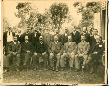
black and white photograph, Howard D. Bulmer, 1907
This photograph shows the Orbost Shire Council in 1907. In the back row are : A. Hillyard; John Draffin (sec.); David Jonson; Archie Rodwell; Hugh Cameron; Geotge Nixon; J. Hassett; Percy Watt; Wm Anderson (engineer); Wm Ross (S.R. Mail) Seated in front on chairs are : Sam Lynn; R. Pearse; John Johnston; Henry Luke (pres.); Donald Munro; Bill Cumming; Charles Grove The shire covered an area of 9,347 square kilometres and existed from 1892 until 1994 when it became part of the East Gippsland Shire Council. Orbost was at first included in the Bairnsdale Shire from 1882 and was later part of the Tambo Shire. Because of travelling distances the Croajingalong Shire was created in 1892 (name changed to Orbost Shire 17.2.1893 with James Cameron as the first Shire President. In 1994 it amalgamated to become part of East Gippsland Shire Council.This item is associated with the Orbost Shire Council. The shire covered an area of 9,347 square kilometres and existed from 1892 until 1994 when it became part of the East Gippsland Shire Council. A large black / white photograph of a group of men in two rows - front row seated; back row standing. The photograph has been taken outdoors with trees in the background and to the right a wooden building and tank. There is a copy.on front - "Orbost Shire Council - 1907" on back - "March, 1907, Shire Council"orbost-shire-council-1907 local-government -
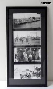 Bendigo Military Museum
Photograph - PHOTOGRAPHS, GRINTON COLLECTION, FRAMED, 2008 - 2009
Frame 11. Photo 1. Welcoming home committee, nearly there. Photo 2. On Australian soil at last. The 'Karmala' berthed at 3MD Melbourne at the "Outer West New Pier" for the Victorians. It is not known if this is the pier at this point. Photo 3. Home at Tragowel, Victoria, some nine miles south of Kerang. Rear, Emily Grinton, Arthur Grinton, Bert and May Grinton. Front. Hughina Grinton and possibly Grace McLeod, Hughina's sister. Photo 4. The opening of the Memorial at Macorna 5/3/1920. Macorna is about 5 kilometres south of Tragowel, both places being on the railway line. Left to right in the photo; Lieut F. Dunn, Cr Charlie Cook, Brigadier General Brand, Rev. G. R. Jones (Kerang) and Mr H. Angus MLA. Music was played by the Mead Brass Band. This information was supplied by the Pyramid Hill Historical Society.Photographs - black and white on paper. 4 photographs top to bottom. 1. Dock side welcoming home committee. 2. Soldiers on a timber dock. 3. Welcome home family group. 4. Opening of a War Memorial. Frame - timber with black colour paint. Glass front. Mount - black colour cardboard. Backing cardboard with handwritten notation.Backing cardboard - handwritten in blue felt tip pen "11."framed photographs, grinton collection, ww1, 38th -
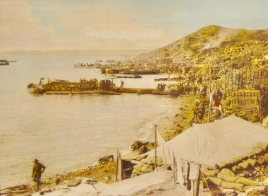 Lara RSL Sub Branch
Framed Photograph of Anzac cove, Anzac Cove 1915
Gallipoli Campaign 1915-6[edit] The first objective for soldiers coming ashore in enemy-held territory was to establish a beachhead, that is a safe section of beach protected from enemy attack where supplies and extra troops could be safely brought ashore. Anzac Cove was always within 1 kilometre (3,300 ft) of the front-line, well within the range of Turkish artillery though spurs from the high ground of Plugge's Plateau, which rose above Arıburnu, provided some protection. General William Birdwood, commander of Anzac, made his headquarters in a gully overlooking the cove, as did the commanders of the New Zealand and Australian Division and the Australian 1st Division. It was on 29 April that General Birdwood recommended that the original landing site between the two headlands be known as "Anzac Cove" and that the surrounding, hitherto nameless, area occupied by his corps be known as "Anzac". Anzac Cove is a small cove on the Gallipoli peninsula in Turkey. It became famous as the site of World War I landing of the ANZACs (Australian and New Zealand Army Corps) on 25 April 1915. The cove is 600 metres (2,000 ft) long, bounded by the headlands of Arıburnu to the north and Little Arıburnu, known as Hell Spit, to the south. Following the landing at Anzac Cove, the beach became the main base for the Australian and New Zealand troops for the eight months of the Gallipoli campaign. Rectangular shaped glass covered picture frame showing Anzac Cove.world war 1,gallipoli,anzac cove,lara r.s.l. ww1 -
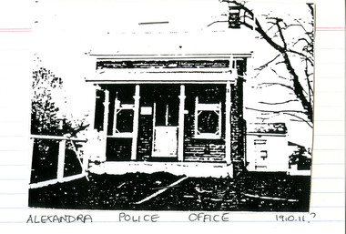 Victoria Police Museum
Police Stations (Alexandra)
Alexandra is a regional centre in the Shire of Murrindindi in Victoria, Australia and 130 kilometres north east of Melbourne. Alexandra Police Station opened in the Benalla Police District on 8 May 1867 in Bon Street, on the north side near Grant Street. When the station opened it was staffed by one Senior Constable; one 1st Constable (Mounted); one Foot Constable. The original building was a nine-roomed brick building with an iron roof on land measuring 84' x 97’. The house included a wash-house, pantry, bathroom, office, one W.C., stabling for three horses, a lock-up with two rooms and a single man's room. It closed in June 1977 and was replaced by a new police station which opened on 16 June 1977 in Bon Street, on land adjacent to the old police station. For a list of Officers in Charge 1871 to 1943 contact Victoria Police Museum1 black and white photo and 3 colour photospolice stations; alexandra police station -
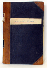 Orbost & District Historical Society
creditors' ledger, 1901 - 1960
This creditors' ledger records information about Shire purchases. The purpose of the Creditors Ledger is to provide knowledge about which suppliers the Shire has paid money to. This ledger was used by the Shire of Orbost pound keeper from 1901 -1960. The item was donated to Orbost & District Historical society from P.R.O.V. as a Place of Deposit (POD) item for safe keeping by a local history group or museum. The shire covered an area of 9,347 square kilometres and existed from 1892 until 1994 when it became part of the East Gippsland Shire Council. Orbost was at first included in the Bairnsdale Shire from 1882 and was later part of the Tambo Shire. Because of travelling distances the Croajingalong Shire was created in 1892 (name changed to Orbost Shire 17.2.1893 with James Cameron as the first Shire President. In 1994 it amalgamated to become part of East Gippsland Shire Council. This item is a hand-written record of the accounts of the Orbost Shire local government. It pre-dates computer records. The Orbost Shire council no longer exists having been absorbed by the East Gippsland Shire council.A large book with a black patterned cover with brown binding, it contains records handwritten in ink. These are records of money paid out by the local government. There are typewritten sheets of sundry creditors added to the back section of the book.hand-written on front cover on white sticker - " Creditor's Ledger" on spine in gold on red - "Ledger" ; on black - "Shire of Orbost" accounts ledger orbost-shire-council -
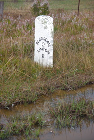 Ballarat Heritage Services
Photograph, LJ Gervasoni, Scarsdale/Linton Milepost (or Milestone), 20-06/2009
Stone mileposts dating from the 1870s are found on the Glenelg Highway. Stone and iron mileposts are now a rarity, and have remanining markers have become a tourist attaction in many smaller towns with remnant markers. The stone mileposts on the Glenelg Highway are listed on the Victorian Heritage Reigister as being significant to the State of Victoria. Their primary purpose is to inform the travelling public of distances and directions to various destinations. The stone milepost in the current City of Ballarat are located on the Glenelg Highway (between Ballarat and Scarsdale), Smythes Creek and Delacombe, and have been registered by Heritage Victoria, (HO155) Other stone mileposts are located In Golden Plains Shire at Smythesdale (Victorian Heritage Register H1701) Metrication in Australia caused former mile markers to be gradually replaced with 10 km markers on highways and country roads, which are referred to as "kilometre plates".Colour photograph of a stone mile post on between Ballarat, Scarsdale and Lintonmilepost, mile post, scarsdale, linton, ballarat, mile marker, stone milepost, milestone -
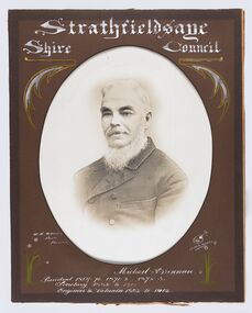 City of Greater Bendigo - Civic Collection
Photograph - Portrait of Councillor Brennan, W H Robinson
The district of Strathfieldsaye was proclaimed in 1861 and named a Shire on the 17th September in 1866. It remained a shire until amalgamation in 1994 when it became part of the City of Greater Bendigo. The shire was located 8 km to the south- east of Bendigo and covered an area of 601 square kilometres and extended from the Calder Highway to the Coliban and Campaspe Rivers. The shire's administration centre was in Strathfieldsaye until 1972 when new offices were opened in Kennington. Councillor Michael Brennan held roles of Shire Secretary and Clark of Works until around 1998 when his son R. B. Brennan was appointed Assistant Secretary and then Shire Secretary to assist his father with the work load during his later years. Michael Brennan remained Clerk of Works until his death at which time his son was appointed to the duties previously held by his father. Framed black and white head and shoulder portrait of Councillor Brennan with hand coloured and drawn detail. Profile to left. Cut oval brown mount decorated with text and flowers. Hand written title top and lower centreStrathfieldsaye / Shire Council / W H Robinson / Photo / Bendigo / J H B Gribble / Michael Brennan / President 1869 - 70. 1871 - 2. 1872 - 3 / Secretary 1882 to 1900 / Engineer & Valuator 1882 to 1902strathfieldsaye shire council, councillor brennan, president of strathfieldsaye shire -
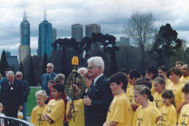 Melbourne Legacy
Photograph, Pilgrimage to the Shrine 1991, 1991
In 1991 a relay of school children ran to the Shrine to coincide with the annual pilgrimage in 1991. A photo shows President John Sullivan holding the Legacy Torch with a group of children in yellow Legacy T shirts at the Eternal Flame at the Shrine of Remembrance on 1 September 1991. Also photos of the widows processing into the Shrine, some with wreaths to lay. From an article in Melbourne Legacy Widows' Newsletter in September 1991 it is a photo of a special torch relay. To coincide with the Annual Pilgrimage to the Shrine of Remembrance over 50 runners covered a 25 kilometre distance from War Grave Memorial in Springvale to the Shrine. President John Sullivan accepted the Legacy torch from the young runners before leading the Legacy family into the Shrine. (From the same roll of film as the event in City Square (00491) and a Legacy dinner with President Sullivan at the head table (00492). A record of children participating in a torch relay during Legacy week ending at the Eternal Flame.Colour photo x 8 of a pilgrimage to the Shrine and a torch relay in 1991. pilgrimage, wreath laying ceremony -
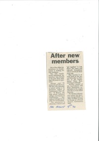 Old Castlemaine Schoolboys Association Inc.
Newspaper Clipping, After New Members, 9/08/1996
One of the oldest associations in Castlemaine is looking for new members. The Old Castlemaine Schoolboys Association was formed in the year 1912, making it 84 years in operation. Anyone over 30 years old and who is an Old Boy who attended a school within 15 kilometre radius of the Castlemaine Post office - St Mary's, the High School, Technical College, (now known as Castlemaine Secondary Colleges) is eligible for membership. The Association is planning a dinner and "get together" to talk about old times and rekindle friendships which existed all those years ago. This reunion is always held on the second Saturday in October, at the Castlemaine Town Hall Starting at 6:30pm. Another Project of the Castlemaine old Boys' Association undertakes is the supply of books to local school Libraries. -
 The Beechworth Burke Museum
Audio - Oral History, Jennifer Williams, Mrs Grace Irvine, 20th April 2000
Mrs Grace Irvine was born in 1907 as one of eight children to the Shennan family in Silver Creek, a town three kilometres east of Beechworth that was considered a part of the town. Her father was a 'wood-carter', contracted to deliver wood to the mining dredges at Silver Creek and the Mayday Hills asylum. Wife to Dick, and mother to four children, Mrs Irvine spent her life in Beechworth, recalling many transformations in its history and living through wars and the Depression. This oral history recording was part of a project conducted by Jennifer Williams in the year 2000 to capture the everyday life and struggles in Beechworth during the twentieth century. This project involved recording seventy oral histories on cassette tapes of local Beechworth residents which were then published in a book titled: Listen to what they say: voices of twentieth century Beechworth. These cassette tapes were digitised in July 2021 with funds made available by the Friends of the Burke.The oral history record of Mrs Grace Irvine is a rare and representative insight into life in Beechworth from the turn of the 20th century to the 21st century, specifically in the descriptions of the everyday, commerce, business, family, and leisure activities for residents of the town throughout war-time and the Depression. Mrs Irvine's recollections have a social value to the Irvine family who have a long enduring history with Beechworth, and so also provide significance to the social and cultural history of the town. This oral history account is socially and historically significant as it is a part of a broader collection of interviews conducted by Jennifer Williams which were published in the book 'Listen to what they say: voices of twentieth-century Beechworth.' While the township of Beechworth is known for its history as a gold rush town, these accounts provide a unique insight into the day-to-day life of the town's residents during the 20th century, many of which will have now been lost if they had not been preserved.This is a digital copy of a recording that was originally captured on a cassette tape. The cassette tape is black with a horizontal white strip and is currently stored in a clear flat plastic rectangular container. It holds up 40 minutes of recordings on each side.Mrs Grace Irvine /listen to what they say, beechworth, oral history, burke museum, irvine, grace irvine -
 Warrnambool and District Historical Society Inc.
Document, Wollaston sale, 1919
This is a poster advertising the sale of part of the Wollaston Estate in Warrnambool in 1919. The sections for sale were Allotments 1, 18 and 19 which included the Wollaston Homestead. The original Wollaston property of 679 acres was selected by Thomas Manifold in the late 1840s. This land, on the northern side of the Merri River, near the Woodford Road was three kilometres from the Warrnambool town. The first farmer we know who leased the property was William Simpson. Walter Manifold inherited the property and he took it over in 1884. The swing bridge he built in 1890 still stands today. In 1919 the Closer Settlement Board of Victoria acquired Wollaston and 17 lots were sold to returned soldiers for farming purposes. By 1930 there were only five soldier settlers remaining. In 2009 further subdivision took place with lots sold for residential purposes. The homestead allotments were sold separately in 1919 with various owners of the homestead itself recorded since that time. This poster is of interest as it shows the areas of the Wollaston Estate which were sold in 1919. The history of this estate is well-documented and of importance in the history of Warrnambool. This is a sheet of paper with red and black printing and a map of the Wollaston Estate which is photo-lithographed. The sheet has been folded three times. It has some small tears at the top of the page. wollaston, history of warrnambool, walter manifold -
 Warrnambool and District Historical Society Inc.
Map, Department of Lands and Survey (Lithographers), Caramut township, 1938
This map of the township of Caramut was produced in 1938 but shows the original land owners of each town allotment and of the surrounding area. The size of all the allotments and the date of the original purchase are also shown. Caramut is a Victorian Western District town on Mustons Creek on the Hamilton Highway 48 kilometres from Warrnambool. This map was used by Rolf Crawley when he was the engineer for the Shire of Warrnambool from 1935 to 1968. The annotations on the map have probably been made by Rolf Crawley as they refer to the records and letter books of his father, John William Crawley, Junior (Shire of Warrnambool Engineer 1895 to 1935). Both Rolf Crawley and his father, John had private businesses as architects, surveyors and engineers and the map could have been used in connection with both their official Shire duties and their private businesses. The last owner of the map was the surveyor, Michael Hand who took over the business of Rolf Crawley in the late 1960s. This map is of great interest firstly because it has all the historical details of the land first purchased in the town of Caramut and area and secondly because it came from the office of Rolf Crawley, the engineer for the Shire of Warrnambool from 1935 to 1968. This is a buff-coloured paper map with a cloth backing. The map details are in black and white print. There are some handwritten red and black annotations on the map. “Town of Caramut Parish of Caramut County of Villiers’town of caramut, john william crawley junior, warrnambool, rolf crawley, warrnambool -
 Warrnambool and District Historical Society Inc.
China, Spoon Rest, Early 21st century
This spoon rest is a souvenir item for tourists to purchase. It is a souvenir of the presence of Southern Right whales at Logans Beach, a few kilometres from Warrnambool’s Central Business District. Each year Southern Right whales have been migrating from sub-Antarctic waters to the east coast of Australia during the winter months. Some whales have been coming each year from approximately May to October (since the 1980s) to have their calves at Logans Beach near Warrnambool. This area is now known as Warrnambool’s Southern Right Nursery. The whales calve about every three years and stay in the local waters along with other whales for about three months and over the past thirty years or so over 100 calves have been born at Logans Beach. The whales are now a winter tourist attraction (if an unpredictable one) as they can be viewed from a raised purpose-built platform area and they are often very close to the shore.This spoon rest is of interest as it is a souvenir of the Southern Right Whale Nursery at Logans Beach, Warrnambool and it has a practical use in the kitchen. It indicates the popularity of whale-viewing at Logans Beach and the importance of the presence of the whales, both scientifically and economically as the annual whale migration to our waters is now a vital aspect of tourism in Warrnambool. This is a Warrnambool souvenir cream-coloured china spoon rest in the shape of a whale or fish. It has a hole at the top for hanging the item on a hook and the printed material is in black and includes a sketch of a mother whale and calf. It has the distributor’s name on the back in yellow writing with an outline of a map of Victoria with a dot to show the location of Warrnambool.‘Southern Right Whale Nursery, Warrnambool’ ‘Lady Bay Creations, Warrnambool, Australia’ southern right whales, warrnambool’s southern right whale nursery, history of warrnambool -
 Warrnambool and District Historical Society Inc.
Book, Third Book, Late 19th century
This little book is very old, presumably 19th century, but the wording on the front cover is indecipherable, no date is evident and the first and last pages are missing. The book was owned by Mary Jane Freckleton with the main inscription written in an adult hand – ‘Mary Jane Frickelton, Mailers Flat’. The spelling of Mailers Flat with an ‘e’ was not a mistake but this was the common spelling in the 19th century and the early 20th century. According to the Freckleton family history ‘Freckleton’ was sometimes spelled ‘Frickelton’ or ‘Frickleton’. Mailors Flat is nine kilometres from Warrnambool and the Mailors Flat School, number 1210, was opened in 1872 in Caramut Road and closed in 1994. The first Head Teacher was Julian Castles. There were Freckelton families in the 19th century in Port Fairy, Caramut, Woolsthorpe, Woodford and Mailors Flat. The Freckletons at Mailors Flat were engaged in farming. Mary Jane Freckleton was for a time a pupil teacher at Mailors Flat School. She was born at the Injemira property and married Henry Giles. This is an interesting book because of its age and because it belonged to Mary Jane Freckleton, a member of the Freckleton families, early settlers in the areas north of Warrnambool. She may have used the book when she was a pupil teacher at the Mailors Flat School. This is a hard cover book of 284 pages (some pages missing). The cloth cover is brown and much torn and stained. There are 86 chapters of prose and verse and a sprig of dried flowers is enclosed in the pages. There is the red stamp of the Warrnambool & District Historical Society on the first page and several snippets of writing in black ink on the front and back pages.‘Mary Jane Frickelton Mailers Flat’mary jane freckleton, mailors flat school -
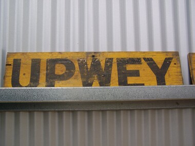 Puffing Billy Railway
Station Sign - Upwey
Upwey Station Sign; Upwey Railway Station is located on the Belgrave line in Victoria, Australia. This railway serves the Eastern region of Melbourne. Upwey Railway Station opened on the 3rd of June 1901. Upwey Railway Station has a crossing loop in the middle of a six kilometre section of single railway track between Ferntree Gully Railway Station and Belgrave Railway Station. The station was originally on the Upper Ferntree Gully to Gembrook narrow gauge line. The Upper Ferntree Gully to Gembrook Narrow Gauge railway line officially closed on the 30th of April 1954. It saw further use between 1955 and early 1958, when trains were operated by the Puffing Billy Preservation Society in co-operation with the Victorian Railways. The Upper Ferntree Gully to Belgrave section was converted to Broad Guage and re-opened on the 19th of February 1962. This station sign shown here was one of a number used on the Upwey Railway Station while it was Narrow Gauge. Historic - Victorian Railways Station sign used at Upwey StationUpwey wooden rectangle Station name sign pained yellow background with black font.Upweypuffing billy, station sign, upwey station, victorian railways -
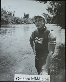 Wodonga & District Historical Society Inc
Photograph - Portrait - Graham Middleton, Rob Elliott, 1993
Graham Wells Middleton was born in Corryong in Northeast Victoria in 1935. He was the first person to swim the length of the Murray River. He began on November 30th 1991 at Bringenbong, near Corryong. After completing a distance of 2366 kilometres over 138 consecutive days, Graham finished his marathon swim in Lake Alexandrina, South Australia on April 14th 1992. This feat was recognised in The Guiness Book of Records and was sponsored by the Rotary Club of Corryong. His motivation was to raise money to help children with cancer. In the process he raised $100,000 for cancer research which made Graham Middleton the first individual in Australia to raise $100,000 for the cause. In the weeks and months after his swim ended, donations continued to be made, with the final total exceeding $200,000. The proceeds raised by the swim were donated to " Kids 'n' Cancer" and the Australian Rotary Health Research Fund. Graham Middleton died on October 27, 1995This photo is significant as Graham Middleton was a resident of Northeast Victoria who made an outstanding contribution to the community and to supporting medical research as a result as the Murray River swim depicted in this image.A black and white photo of Graham Middleton, a marathon swimmer who swam the Murray River. The photo has been mounted in a metal frame.graham middleton, murray river, murray river swim