Showing 4636 items
matching history records
-
 Orbost & District Historical Society
book, Footprints, 2008
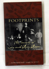
Co-author Simon Flagg from the Koorie Records Unit, Public Record Office Victoria, did most of the research for the book. Rita Watkins, a descendent of Percy and Lucy, provided photographs and family stories for the book. "As well as brief chapter introductions, the book contains transcripts of the letters to, from and about the Pepper Family. Among various aspects of the family's life, the letters show Lucy Pepper's long battle with tuberculosis and her request to live with other family members on a mission. But she was denied this natural wish because 'half-caste' Aboriginal people were excluded from the missions." -co-author Simon Flagg from the Koorie Records Unit, Public Record Office Victoria,This book, with its transcripts of original letters, is an invaluable historical resource for university and school students on Aboriginal history in Victoria and what happened on Aboriginal reserves. A book titled "Footprints", which portrays the struggles of Lucy and Percy Pepper in the first half of the twentieth century. It was published jointly by the National Archives of Australia and Public Record Office Victoria, both of which hold original records of the family's correspondence with bureaucracy over the years. The book was authored by Simon Flagg and Dr Sebastian Gurciullo. The cover has a dark brown background with black footprints printed over it. They are both bare foot and shoe prints. It has a b /w photograph of a family posed for the camera. Across the top is the title FOOTPRINTS printed in pale yellow. At the bottom of the photo in pale yellow script is "the journey of Lucy and Percy Pepper". At the foot of the front cover is " An Aboriginal Family's struggle for survival". pepper-family aboriginal-history -
 Orbost & District Historical Society
black and white photograph, 1890's
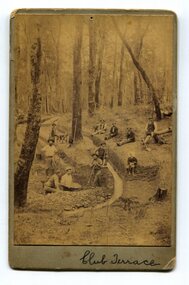
This item was found in the collection with no information recorded. On the back is a short message wishing a happy Christmas to Bessie and Jack from M.W. The photograph shows miners at Club Terrace.This item is a pictorial record of the gold mining history of East Gippsland.A yellowed black / white photograph on grey buff card. It is of men panning for gold and digging trenches.on front - " Club Terrace" on back - " To Bessie, Jack from M.W."club-terrace gold-mining gold-panning gold -
 Orbost & District Historical Society
black and white photograph, 1913
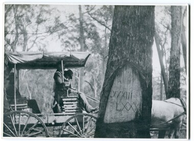
When marking a boundary for a registered plan, a surveyor would place “Reference Marks” with a stated bearing and distance to a boundary corner. These trees were typically marked by cutting the bark of the tree in a shield or blaze. Until July 1886, surveyors were only able to use trees as reference marks to boundary corners. After July 1886 surveyors were able to use “permanent marks” which were either a glass bottle, gas pipe or iron bolt (for homestead surveys only). This photograph shows the reference tree, 83 miles from Marlo via the original surveyed road v ia Sydenham Inlet and Tamboon, south of Mount Drummer to the New South Wales border - now the Princes Highway.This is a pictorial record of an old survet tree. Knowledge of their location, abundance and condition not only provide important insights to past survey practice, but also provide a lasting legacy of a regions land-use history. Old survey trees serve as one of the few remaining physical legacies of early European land settlement history.A large black / white photograph of a horse and buggy pulled up alongside a reference tree which has notches and markings of Roman numerals.on back - " Refernce tree 83 miles from Marlo........to N.S.W. Border"survey-tree reference-tree -
 Orbost & District Historical Society
photograph / postcard, early 20th century
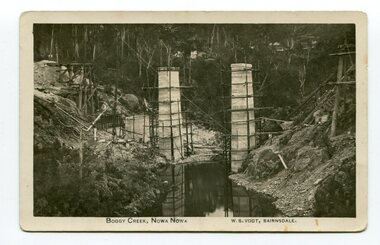
Boggy Creek Bridge was built in 1916 as part of the Bairnsdale to Orbost extension to the main Gippsland Railway, and is situated in the middle of the township of Nowa Nowa, crossing a steep-sided and well-timbered creek-valley. This section of the line closed in 1987.This item is a pictorial record of the construction of the Boggy Creek railway bridge on the East Gippsland line. This bridge plays a major part in the identity and history of the town of Nowa Nowa, since Boggy Creek’s steep sided valley divides the township into two components. A black / white photograph on a postcard showing the construction of a railway bridge across a creek. The end pylons are evident and there is scaffolding on both sides of the creek. Two copies of a black / white photograph showing the construction of a railway bridge across a cree. The end pylons are evident and there is scaffolding on both sides of the creek. There is a steam train on the rail track.on front of postcard - caption - " Boggy Creek, Nowa Nowa, W.S. Vogt, Bairnsdale"boggy-creek-bridge vogt-w.s. railway-bridges east-gippsland-railway railway-construction train -
 Orbost & District Historical Society
black and white photograph, 1920s
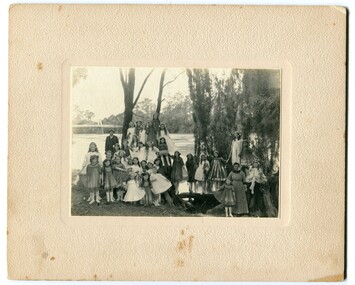
The bridge shown in the background was built in the 1920s as a road and rail bridge, and was partly washed away by flood waters in 1934. There is no known history of this item.This photograph is a contemporary record of rural life in Orbost in the early 20th century.A black / white photograph of a group of young girls dressed up and posing on the banks of a river. On the left hand side of the photograph is an older man and on the right is an older lady. In the background is a bridge - the first Snowy River bridge. The photograph is on a cream coloured buff card. orbost snowy-river -
 Orbost & District Historical Society
black and white photograph, late 19th - early 20th century
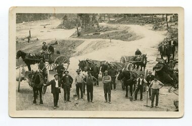
This photograph shows men working goldfields - possibly the battery mines at Club Terrace or near Bendoc? Clarkeville?This item is a pictorial record of the gold mining history of East Gippsland.A black / white postcard / photograph of a group of miners in the foreground with horses an wagons in the background on gold fields.gold-mining-east-gippsland -
 Orbost & District Historical Society
black and white photograph, April 20 1970
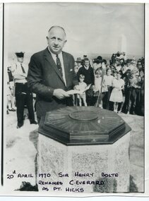
Sir Henry Bolte, premier of Victoria, renamed Cape Everard at Point Hicks during the Centenary of Cook's Landings on April 20, 1970. There is no land feature at Cook's coordinates of 38°0'S and 148°53'E, a point which lies several miles out to sea and under 50 fathoms of water. Captain Cook invented Point Hicks so that he could conceal Bass Strait and the insularity of Tasmania. The Admiralty had issued its usual instructions to hide strategically important discoveries that could become security risks. Captain Hicks was James Cook`s senior lieutenant. There has been some dispute as to whether Zachary Hicks actually saw Point Hicks or whether he saw Ram Head about 20 kilometres further up the coast. Although Cook named the promontory Point Hicks it was changed to Cape Everard in 1843.. In 1970 the Victorian government changed the name Cape Everard to 'Point Hicks'. It lies on dry land, about 22 nautical miles (41 km) northeast of Cook's phantom Point Hicks, where it preserves the story of Cook's first landfall in Australia. This is a contemporary pictorial record of a significant event in East Gippsland's history.A black / white photograph of a man in a suit making a speech with the audience standing behind him. He is standing in front of an octagonal-shaped directional marker set ointo a stone support. There is a policeman behind him. In the background to the right is a lighthouse.on front - "20th April 1970, Sir Henry Bolte renames C. Everard as Pt Hicks" handwritten in block letterscook-james-point-hicks cape-everard bolte-henry -
 Orbost & District Historical Society
black and white photograph, second half 20th century
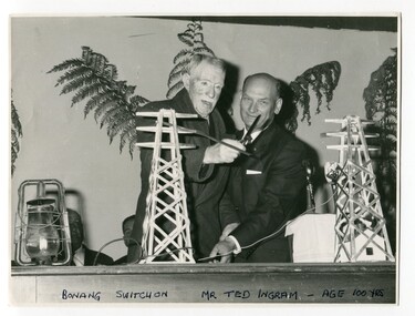
This was the switch on ceremony for the power going to Bonang. The ribbon was cut by Mr Ted Ingram at the age of 100. Ted Ingram, was one of 22 children. The Ingram family originated from the Bombala, Bonang and Delegate area, migrating throughout out the rich farming country of East Gippsland in the early 1900s.This is a pictorial record of a significant event in the history of East Gippsland.A black / white photograph of two men cutting the ribbon at an official occasion. The ribbno is strung between to models of electricity pylons. On the table to the left is a kerosene lantern.on front - "Bonang Switch on, Mr Ted Ingram, age 100 years"bonang-electricity-supply ingram-ted -
 Orbost & District Historical Society
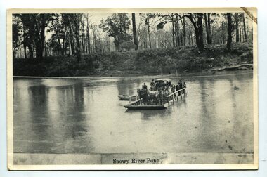
black and white photograph, late 19th century
A punt crossed the Snowy River at Orbost from 1884. A bridge was constructed in 1893, but was soon damaged by a huge flood. Flooding was a regular occurrence, the worst inundations being in 1870, 1893, 1925, 1934, 1952 and 1971. Over the years major flood protection works have been implemented. The Princes Highway, which passes Orbost, now crosses the flood plain on raised concrete supports. (info, from Victorian Places Orbost)This item is associated with the Snowy River and its history. It is a pictorial record of transport in the late 19th century.A black / white photograph (copy) of a punt loaded with people and a horse-drawn carriage making its way across a river.on front at bottom - "Snowy River Punt"snowy-river-orbost transport shipping -
 Orbost & District Historical Society
black and white photograph, first half 20th century
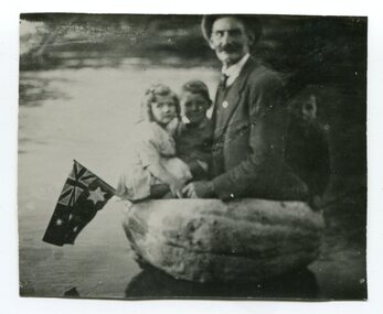
The pumpkin in this photograph was an award winner and was grown by Fred Mundy Snr. It weighed 194 lbs (approx. 88 kgs). Pumpkins were grown widely on Orbost farms and used to feed pigs. There was usually a competition for the heaviest or biggest pumpkin at the annual Orbost agricultural Show.This photograph is associated with the history of pumpkin growing in the Orbost district.A small black / white photograph of man with three children sitting in a hollowed out pumpkin in water. An Australian flag is on the left side of the pumpkin.on back - "Alec Cameron, Mr Fred Mundy" ; "Record pumpkin - Mr Fred Mundy 194lbs"mundy-fred pumpkins-orbost -
 Orbost & District Historical Society
black and white photograph, Sherwood, first half 20th century
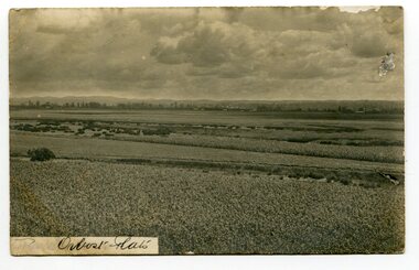
This postcard is addressed to Tom Lloyd from Uncle Frank c/o F. Lloyd Esq, Bairnsdale.This item is a pictorial record associated with the agricultural history of Orbost. .The extensive Snowy river flood plain was swampy, but by the 1880s the river flats were being drained. The Orbost flats are very fertile and crops were planted on the rich deep soil, with maize rapidly becoming widespread.A black / white photograph of the Orbost farming flats. The sky is very cloudy. There are paddocks of crops in the foreground.on front - "Orbost Flats" on back - "How are you enjoying your holiday.......Uncle Frank"orbost-flats-farming lloyd-frank -
 Orbost & District Historical Society
black and white photograph, March 1937
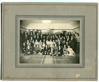
This is a photograph of the "Diggers Reunion" for the "Back To" celebrations held in Orbost in March 1937.This is a pictorial record of a significant event in Orbost's history.A black / white photograph on a grey buff card. It shows a large group of people sitting or standing on the floor of what appears to be a church hall.on back - "Mrs Mars. View St ?????????" on front - "Diggers Reunion Back to Celebrations Orbost 3.3.37"orbost-back-to-celebration festivals -
 Orbost & District Historical Society
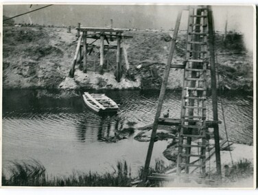
black and white photographs, 1915
... at the right / Gordon " This is a pictorial record associated ...This photograph is of the construction of the first road bridge over the Genoa River - 1915. Before today's timber truss and concrete bridge was constructed between 1926-1928 by contractor J.T. Noble Anderson, two earlier bridges crossed the Genoa River at this location. They provided crucial links in the Princes Highway route from Melbourne to Sydney. The letter on the back of the postcard was written by Gordon ? to Alex ? on 2nd October 1917. "this represents the opening of Genoa Bridge. Mrs Alexander cutting the ribbon and Mr Martin holding it at the other side. Did most of the speaking. The gent holding the roll of paper is who came to open the bridge. I can't think of his name. Hubert is standing up at the right / Gordon " This is a pictorial record associated with the history of Genoa in East Gippsland.1100 -A large black / white photograph on a cream coloured buff card. It is of an unfinished bridge with men working there. A small rowboat can be seen on the far side of the river. 1100.1 - A photograph / postcard of the opening of "Genoa Bridge 1917". There is a ribbon stretched across the timber decking road in front of a group of people. 1100.2 - A black / white photograph of a road bridge across a river.on back - "Princes Highway - the 1st bridge over the Genoa River - 1915" on back of 1100.1 is a hand-written letter.genoa-bridge princes-highway-east-gippsland -
 Orbost & District Historical Society
black and white photograph, first half 20th century
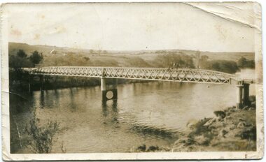
This is the Dalgety bridge across the Snowy River. It is a steel construction.The first bridge over the river was constructed in 1888. There was a punt across the river before the bridge was built . Dalgety is a small service centre, located on the Snowy River approximately 235 km from Orbost. It was an early consideration for the site of Australia,s capital city. The Dalgety Bridge over the Snowy River has been an important item of infrastructure in the history of New South Wales for over 110 years. It was designed by noted bridge engineer J. A. McDonald,and was a technically sophisticated bridge structure for its time. This is a pictorial record of a significant structure on the Snowy River.A small black / white photograph of a large bridge over a river.bridge-dalgety-snowy-river -
 Orbost & District Historical Society
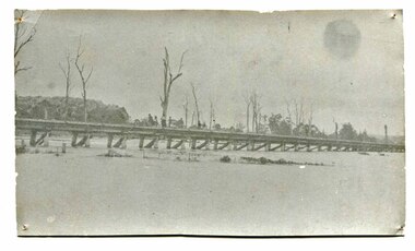
black and white photograph, January 1934
Orbost has been subject to major floods throughout its history, such as those which left the town isolated in 1934, 1952, 1971 and 1978. It is recorded that the Snowy River broke its banks and flooded the flats 104 times between 1884 and 1978. Extensive flooding in Eastern Victoria during June 1978, caused widespread damage to roads, road closures and hazards to traffic, particularly over the Queen's Birthday holiday weekend.This is a pictorial record of a significant event in Orbost's history.A very faded black / white photograph of flood water under the railway viaduct at watt's Gulch.orbost-flood-1934 railway-viaduct-orbost -
 Orbost & District Historical Society
black and white photograph, July 1922
A new bridge over the Snowy River at Orbost was opened for traffic on June 20th 1922. It was designed for future joint use by road and railway traffic, but it was only used for road traffic. During the last few years the condition of an old suspension bridge [the 1893 bridge] which was the only vehicular crossing between the town of Orbost and the railway station, caused much concern. The structure was of timber, except for the wire suspension cables of its central span of about 100 feet. A design was prepared in 1914 for a permanent bridge with five spans of 85 feet composed of plate girders on concrete piers. With great increase in the price of steel work during the war, the cost of this design became prohibitive, and the need for a new structure becoming urgent, alternative proposals were investigated. As a result the present design was adopted as providing a sem-permanent bridge at moderate cost. The new bridge spans the river about 160 feet upstream from the old bridge on a slight skew, the piers being at an angle of 80 degrees with the centre line of the bridge. It has a camber of about 2 feet 5 inches in its total length of 527 feet. ( information from Newsletter March 2014 - Lois Crisp) The photograph shows Mrs James Cameron cutting the ribbon at the opening of the Orbost Pile Bridge in 1922. This second bridge, was built by the Victorian Railways and the Country Roads Board. Constructed at a cost of 35,000 pounds and used second-hand girders from the Flinders Street- Spencer Street viaduct. On July 4 1922 it was officially opened by Mrs James Cameron. Unfortunately, her husband, who had long championed the building of the bridge so that it would be ready for the railway to continue to the border, was too ill to attend the ceremony. In fact, James Cameron died on July 13 after a long and severe illness (ref. S.R.M. 20.7.1922). There is a section of this ribbon in the collection - Registration No. 366. This is a pictorial record of a significant event in Orbost's history.A black / white photograph of a pile bridge with a suspension bridge behind it. There are many people standing on the bridge.on back - "Opening of Pile Bridge - 1922"snowy-river-bridge ceremonies cameron-mrs -
 Orbost & District Historical Society
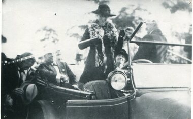
black and white photograph, July 1922
The photograph shows Mrs James Cameron cutting the ribbon at the opening of the Orbost Pile Bridge in 1922. The first bridge was officially opened in August, 1893 (ref. S.R.M. 12.8.1893) by Mrs W. Watt, the mother of Councillor Watt, who presided over the opening of the 1922 bridge. This bridge was extensively damaged when a herd of cattle allegedly stampeded over it causing the cable to snap. Even after repairs it became obvious that a new bridge was needed. This second bridge, was built by the Victorian Railways and the Country Roads Board. Constructed at a cost of 35,000 pounds and used second-hand girders from the Flinders Street- Spencer Street viaduct. On July 4 1922 it was officially opened by Mrs James Cameron. Unfortunately, her husband, who had long championed the building of the bridge so that it would be ready for the railway to continue to the border, was too ill to attend the ceremony. In fact, James Cameron died on July 13 after a long and severe illness (ref. S.R.M. 20.7.1922). There is a section of this ribbon in the collection - Registration No. 366.This item is a pictorial record of a significant event in Orbost's history.A black / white photograph of a lady standing up in a motor vehicle cutting a ceremonial ribbonsnowy-river-bridge-orbost cameron-mrs ceremonies -
 Orbost & District Historical Society
black / white photograph, January 1934
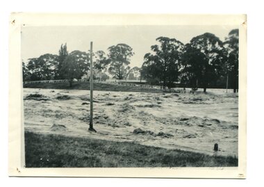
Damage estimated at £500,000 was caused by the 1934 floods in the Orbost district. This 1934 flood was devastating, destroying a section of the 1922 Orbost bridge, wrecking fences, bridges and roads, dumping silt and debris on the rich river flats and drowning cattle. This photograph shows Lochiel Lagoon ( the billabong) in the foreground. Ten minutes after this photograph was taken, the centre span of the Orbost Bridge was washed away.This item is a pictorial record of the 1934 floods, a significant part of Orbost's history.A black / white photograph of swirling floodwaters with township in the background.orbost-floods-1934 natural-disasters-floods -
 Orbost & District Historical Society
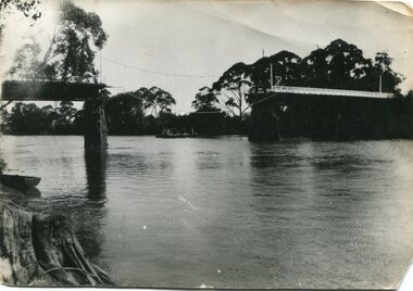
black and white photograph, January 1934
Damage estimated at £500,000 was caused by the 1934 floods in the Orbost district. This 1934 flood was devastating, destroying a section of the 1922 Orbost bridge, wrecking fences, bridges and roads, dumping silt and debris on the rich river flats and drowning cattle. The centre span of the Orbost Bridge was washed away. This item is a pictorial record of the 1934 floods, a significant part of Orbost's history.A black / white photograph showing the flood damage to the Snowy River Bridge. There is a gap in the bridge where the centre span has been washed away. In the background is a punt.orbost-floods-1934 natural-disasters-floods snowy-river-bridge -
 Orbost & District Historical Society
black and white photograph, February, 1971
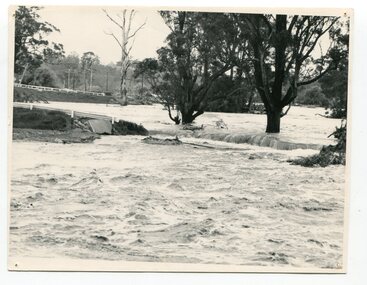
This photograph shows the floodwaters during the 1971 flood at Orbost. The two mahogany trees in the photograph stopped the Snowy River from changing its course. The 1971 flood was the the worst flood on record. At Jarrahmond it was at least 11 metres and up to one and a half kilometres wide on the flats causing enormous damage to the flood plain. Records say that "The brown floodwater stain in Bass Strait could be seen from passing airliners." Considerable damage was done to railway infrastructure, roads and farms. More information from the APRIL, 2008 newsletter by John Phillips. (see orbosthistory.com.au)This is a pictorial record of a significant event in the history of floods in Orbost.A black / white photograph of raging floodwaters at the bottom of the Orbost township.orbost-flood-1971 -
 Orbost & District Historical Society
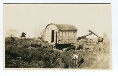
black and white photograph, first half 20th century
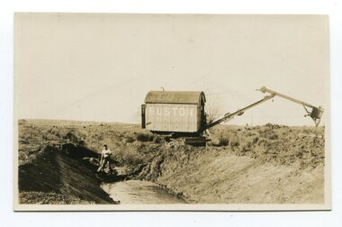
Ruston & Hornsby, later known as Ruston, was an industrial equipment manufacturer in Lincoln, England, the company's history going back to 1840. The company is best known as a manufacturer of narrow and standard gauge diesel locomotives and steam shovels. This machine is probably a drag line excavator.This photograph records early an early type of excavator used to construct drainage channels in rural Victoria.A black / white photograph / postcard of a man digging in a very large trench, probably a drainage channel, with an earth mover in the background. The machine has the name "RUSTON" on it.drainage-channel earth-moving-machinery -
 Orbost & District Historical Society
black and white photograph, first half 20th century
Ruston & Hornsby, later known as Ruston, was an industrial equipment manufacturer in Lincoln, England, the company's history going back to 1840. The company is best known as a manufacturer of narrow and standard gauge diesel locomotives and steam shovels. This photograph records early an early type of excavator used to construct drainage channels in rural Victoria.A black / white photograph / postcard of a man digging in a very large trench, probably a drainage channel, with an earth mover in the background. The machine has the name "RUSTON" on it.drainage-channel earth-moving-machinery -
 Orbost & District Historical Society
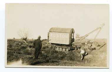
black and white photograph, first half 20th century
Ruston & Hornsby, later known as Ruston, was an industrial equipment manufacturer in Lincoln, England, the company's history going back to 1840. The company is best known as a manufacturer of narrow and standard gauge diesel locomotives and steam shovels. This photograph records early an early type of excavator used to construct drainage channels in rural Victoria.A black / white photograph / postcard of a man digging in a very large trench, probably a drainage channel, with an earth mover in the background. The machine has the name "RUSTON" on it. In the foreground is a man, dressed in a long dark coat, watching.agricultural-machinery drainage-channels ruston -
 Orbost & District Historical Society
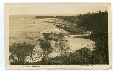
black and white photograph, Vogt, Stanley, first half 20th century
This is a scene of Cape Conran, East Gippsland taken by Bairnsdale photographer, Stanley Vogt. It was probably one of a collection of commercial post cards available to tourists or East Gippsland residents to send to friends or relatives. Cameras in the early 20th century were not a common family possession and a postcard was a common souvenir and way of sending a short message.Between 1901 and 1914 a wide range of subjects were recorded by often anonymous artists and photographers and published by everyone from major companies to enthusiastic individuals. As a result, postcards provide a comprehensive resource for anyone interested in how our forebears lived, laughed and loved one hundred years ago. They are very interesting records of places gone, architecture gone and people gone, showing social history such as dress, or early automobiles. Postcards form a vital part of social and historical records for researchers. A black / white postcard photograph of a scenic view of the beach and ocean at Cape Conran in Far East Victoria.on front - "Stanley Voigt - Bairnsdale - Cape Conran"postcard-cape-conran -
 Orbost & District Historical Society
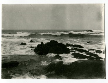
first half 20th century
This is a scene of Cape Conran, East Gippsland. It appears to have been a postcard which was trimmed. Cameras in the early 20th century were not a common family possession and a postcard was a common souvenir and way of sending a short message.Early photographs are very interesting records of places gone, architecture gone and people gone, showing social history such as dress, or early automobiles. This scene is of a popular tourist destination in East Gippsland.A black / white photograph of a rough ocean over rocks at Cape Conran in Far East Gippsland. It looks as if the photograph has been trimmed.cape-conran -
 Orbost & District Historical Society
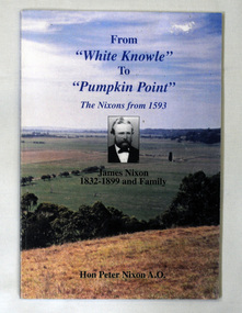
book, From "White Knowle" to "Pumpkin Point", 2004
... district since 1885. This book records the history of the Nixon ...Peter Nixon, the author of this book, grew up on the family farm on the Snowy River. He entered Federal Parliament in 1961 as the Member for Gippsland, holding various portfolios before retiring in 1983. The Nixon family has been in the Orbost district since 1885.This book records the history of the Nixon family and its association with Orbost.A book, titled From White Knowle to Pumpkin Point, the Nixons from 1593. On the cover is a coloured photograph of Pumpkin Point, taken by Peter Nixon, the author. There is a b/w photograph of James Nixon, with the caption, James Nixon 1832-1899 and Family, beneath it. The book is a compilation of stories and b/w photographs of the the first three generations of Nixons in Australia. There is a brief history of the Nixons in 1593 - the earliest records.2136.1 has "With compliments Peter Nixon 6/7/04" inside.nixon-family orbost-history nixon-james pumpkin-point snowy-river -
 Orbost & District Historical Society
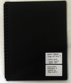
folder, Daniel Moylan (Dan the Cook), October 2012
This research record was part of a thesis that Mary Doland was preparing.This record is an excellent research tool for the study of the Indigenous history of Orbost.A 38 pp black spiral bound plastic folder containing a CD and research evidence compiled by Mary Doland on the topic of Dan Moylan, known as "Dan the Cook". He was speared to death in 1851 at Orbost Station, Snowy River.handwritten on a white label - Daniel Moylan handwritten on a white label below -Information researched and supplied by Mary Doland (Dan the Cook) Orbost grave Orbost station death 1851daniel-moylan aboriginal-history-orbost -
 Orbost & District Historical Society
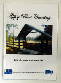
book, Gypsy Point Cemetery
The book was published by the Gypsy Point Cemetery Trust with support from the Public Record Office of Victoria.This book is a useful reference book.A small 27 pp book with a coloured photograph on the front cover. It is an archway entrance to a cemetery. The book contains burial information from 1919 to 2009.gypsy-point-history -
 Orbost & District Historical Society
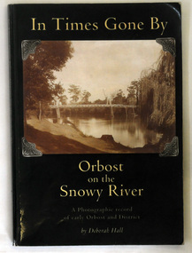
book, In Times Gone By, 2002
... the memories of Orbost locals as well as to record its early history.... the memories of Orbost locals as well as to record its early history ...The book was written by Deborah Hall in order to preserve the memories of Orbost locals as well as to record its early history. Local history tends to be less documented than other types, with fewer books and artifacts than that of a country or continent. Many local histories are recorded as oral tales or stories and so are more vulnerable than more well known issues. Because it records in a scholarly way the meories of local residents, Deborah Hall's book is a commonly used reference for the early history of Orbost and districtA 158 pp book titled In Times Gone By Orbost on the Snowy River. It is a photographic record of early Orbost and District. It has a dark green coverwith a photograph of the first pile bridge over the Snowy river at Orbost. The book was authored by Deborah Hall.orbost-history reminiscences hall-deborah -
 Orbost & District Historical Society
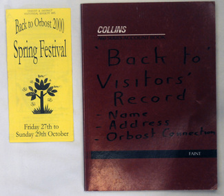
brochure, Osborne, Janette, Back To Orbost 2000 Spring Festival, 2000
Brochure and book produced for the Back To Orbost Celebrations , Spring Festival in 2000.This is a locally produced book useful for research on the history of Orbost.2195.1 is a yellow brochure with black print. Fold-out format. Titled Back To Orbost 2000 Spring Festival. Friday 27th to Sunday 27th October. 2195.2 is a record of attendance book. It has a red cover and contains signatures, names and addresses.orbost-history celebrations reunions