Showing 98 items matching " tower erected"
-
 Bendigo Historical Society Inc.
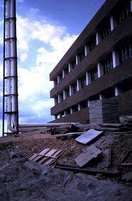
Slide - RALPH BIRRELL COLLECTION: EIG SCHOOL, C1966
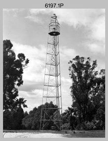
... ... tower erected...Building appears complete, tower has been erected, site needs to be cleaned up of building supplies. ...Building complete tower erected site needs cleaned up Kodak EIG School - Ralph Birrell Collection. - Construction of Latrobe Uni. ...EIG School - Ralph Birrell Collection. - Construction of Latrobe Uni. C1966, 1972. Bendigo Institute of Technology, Engineering School, Applied Science. Building appears complete, tower has been erected, site needs to be cleaned up of building supplies. Markings: OCT72M2Kodakeducation, tertiary, latrobe university bendigo, eig school - ralph birrell collection. - construction of latrobe uni. c1966, 1972. bendigo institute of technology, engineering school, applied science. building complete, tower erected, site needs cleaned up -
 Charlton Golden Grains Museum Inc
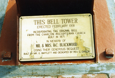
Photograph, Bartlett G, c.1991
... This bell tower erected February 1991 incorporating the original bell from the Charlton Presbyterian church built in 1871. ...This bell tower erected February 1991 incorporating the original bell from the Charlton Presbyterian church built in 1871. ...Charlton Golden Grains Museum Inc 1 High Street Charlton goldfields This bell tower erected February 1991 incorporating the original bell from the Charlton Presbyterian church built in 1871. ...This bell tower erected February 1991 incorporating the original bell from the Charlton Presbyterian church built in 1871. In memory of Mr & Mrs R&C. Blackwood using their generous bequest. Built by Mr. G. Bartlett and dedicated by Rev. G Dyason.Standard colour photograph with no borderThis bell tower erected February 1991 incorporating the original bell from the Charlton Presbyterian church built in 1871. In memory of Mr & Mrs R&C. Blackwood using their generous bequest. Built by Mr. G. Bartlett and dedicated by Rev. G Dyason.charlton, church, charlton presbyterian church, bell tower, blackwood r&c, pastoral care, bartlett g., dyason rev. g -
 Ringwood and District Historical Society
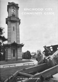
Book, Ringwood City Community Guide (1976-77), 1976
... "Front cover photograph: Memorial Clock Tower erected in 1928."..."Front cover photograph: Memorial Clock Tower erected in 1928." Ringwood Community Guide containing Council editorial, brief history of Ringwood, local Community Services and Business Listings. ...Ringwood Community Guide containing Council editorial, brief history of Ringwood, local Community Services and Business Listings. Also includes a street directory map of Ringwood Municipality, and a 1976-1977 Calendar."First Edition". "Front cover photograph: Memorial Clock Tower erected in 1928."rinx -
 Glenelg Shire Council Cultural Collection
Photograph - Photograph - Tower erection, n.d
... Black and white photo. A tower being erected....Glenelg Shire Council Cultural Collection History House Cliff Street Portland great-ocean-road Sourced from Casterton Town Hall (Former Shire of Glenelg) Back: '31/2 " ' on blue biro line arrowed both ends, drawn across photo Black and white photo. A tower being erected. Photograph Photograph - Tower erection ...Sourced from Casterton Town Hall (Former Shire of Glenelg)Black and white photo. A tower being erected.Back: '31/2 " ' on blue biro line arrowed both ends, drawn across photo -
 City of Ballarat Libraries
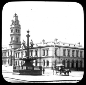
Glass Slide, Ballarat Post Office
... Ballarat Post Office, ne corner Sturt and Lydiard Streets, image not dated but tower erected 1885. In foreground Burke and Wills memorial fountain, erected 1867....The set and its subjects indicate these images were produced to promote Ballarat and were perhaps aimed at tourists. horse and cart fountain telegraph pole Ballarat Post Office, ne corner Sturt and Lydiard Streets, image not dated but tower erected 1885. In foreground Burke and Wills memorial fountain, erected 1867. ...It is believed the ball on the tower flag pole was raised and lowered to indicate when mail had been sorted and was ready.Previously unknown image of Ballarat. The set and its subjects indicate these images were produced to promote Ballarat and were perhaps aimed at tourists.Ballarat Post Office, ne corner Sturt and Lydiard Streets, image not dated but tower erected 1885. In foreground Burke and Wills memorial fountain, erected 1867.horse and cart, fountain, telegraph pole -
 St Kilda Historical Society
Photograph, Carlo Catani Memorial Clock Tower unveiling, c1930, c. 1930-1931
... Unveiling the memorial clock tower erected on the site formerly occupied by the bandstand, Upper Esplanade. ...St Kilda Historical Society St Kilda Branch Library 150 Carlisle Street St Kilda melbourne Upper Esplanade, St Kilda Unveiling the memorial clock tower erected on the site formerly occupied by the bandstand, Upper Esplanade. ...Upper Esplanade, St Kildablack and white photograph, original, mounted, good conditionUnveiling the memorial clock tower erected on the site formerly occupied by the bandstand, Upper Esplanade. Erected in memory of Carlo Catani, former Chief Engineer of the Public Works Department. Taken late 1930 or early 1931. Original photo held by St.K.C.C' c.74 -
 Kiewa Valley Historical Society
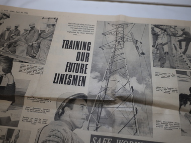
Newspaper - Linesman - S.E.C News 1966, Training our Future Linesmen
... Linesmen worked on the SEC power towers erecting the towers and supplying lines. ...Kiewa Valley Historical Society Mount Beauty Information Centre 31 Bogong High Plains Rd Mt Beauty high-country Linesmen worked on the SEC power towers erecting the towers and supplying lines. ...Linesmen worked on the SEC power towers erecting the towers and supplying lines. They were also responsible for the maintenance of the lines. The article has photos of the men undergoing training with an emphasis on safety.The SEC constructed the Kiewa Hydro Electric Scheme and were resposible for the erection of the power towers and lines enabling the electricity to be distributed throughout the state of Victoria and beyond.Pages 6 and 7, S.E.C. News, April 28, 1966 Article 'Safe Working Paramount' with 9 photos including names of the men working.linesmen, power towers, electric power lines, sec training -
Glenelg Shire Council Cultural Collection
Photograph - Photograph - No. 6 berth construction, Portland, n.d
... Black & white photo of a tower being erected on No 6 Berth. Two cranes present, one with a bucket containing 2 men....Glenelg Shire Council Cultural Collection History House Cliff Street Portland great-ocean-road Port of Portland Authority Archives Port of Portland Archives construction Portland harbour Black & white photo of a tower being erected on No 6 Berth. Two cranes present, one with a bucket containing 2 men. ...Port of Portland Authority Archivesport of portland archives, construction, portland, harbour -
 Tatura Irrigation & Wartime Camps Museum
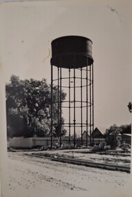
Photograph, First Water Tower in Tatura
... Iron watertank, the first water tower in Tatura, erected at rear of Rodney Shire Offices, built c1888...Tatura Irrigation & Wartime Camps Museum 49 Hogan Street Tatura the-murray buildings historic Iron watertank, the first water tower in Tatura, erected at rear of Rodney Shire Offices, built c1888 First Water Tower in Tatura Photograph Photograph ...Iron watertank, the first water tower in Tatura, erected at rear of Rodney Shire Offices, built c1888buildings, historic -
 Charlton Golden Grains Museum Inc
Photograph, Bartlett G, c.1991
... This bell tower erected February 1991 incorporating the original bell from the Charlton Presbyterian church built in 1871. ...Charlton Golden Grains Museum Inc 1 High Street Charlton goldfields This bell tower erected February 1991 incorporating the original bell from the Charlton Presbyterian church built in 1871. ...This bell tower erected February 1991 incorporating the original bell from the Charlton Presbyterian church built in 1871. In memory of Mr & Mrs R&C. Blackwood using their generous bequest. Built by Mr. G. Bartlett and dedicated by Rev. G Dyason. Located at Charlton Uniting Church (formerly Methodist), Halliday Street.Standard colour photograph with no border.charlton, church, charlton presbyterian church, bell tower, blackwood r&c, pastoral care, bartlett g., dyason rev. g -
 Phillip Island and District Historical Society Inc.
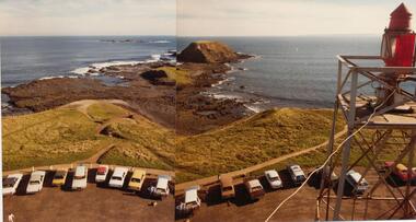
Photograph, John Cook, 1978-79
... Two joined coloured photographs showing a view of The Nobbies & Seal Rocks from the newly erected Beacon Tower in 1979. The older tower can be seen on the right of the photograph....Phillip Island and District Historical Society Inc. phillip-island-and-the-bass-coast The Nobbies & Seal Rocks is the extreme western tip of Phillip Island. coloured photograph the nobbies phillip island seal rocks phillip island john cook Two joined coloured photographs showing a view of The Nobbies & Seal Rocks from the newly erected Beacon Tower in 1979. The older tower can be seen on the right of the photograph. ...The Nobbies & Seal Rocks is the extreme western tip of Phillip Island.Two joined coloured photographs showing a view of The Nobbies & Seal Rocks from the newly erected Beacon Tower in 1979. The older tower can be seen on the right of the photograph.coloured photograph, the nobbies phillip island, seal rocks phillip island, john cook -
 Warrnambool and District Historical Society Inc.
Booklet - Christ Church Warrnambool, Christ Church Warrnambool Diamond Jubilee 1850-1910, 1910
... The foundation stone of Christ Church was laid in 1855 and the church was consecrated in 1862. A tower was erected in 1881. At the time of the Diamond Jubilee the Anglican Minister in Warrnambool was Archdeacon Peacock. ...The foundation stone of Christ Church was laid in 1855 and the church was consecrated in 1862. A tower was erected in 1881. At the time of the Diamond Jubilee the Anglican Minister in Warrnambool was Archdeacon Peacock. ...This booklet was produced for the Diamond Jubilee of Christ Church, Warrnambool in 1910. The Anglican Church was established in Warrnambool in 1850 with the arrival of the first minister, the Rev. Peter Beamish. He served in the Warrnambool district until 1895. The foundation stone of Christ Church was laid in 1855 and the church was consecrated in 1862. A tower was erected in 1881. At the time of the Diamond Jubilee the Anglican Minister in Warrnambool was Archdeacon Peacock. This booklet is of interest because it is a memento of the 1910 Diamond Jubilee celebrations at Christ Church, Warrnambool. This is a soft cover booklet of 24 pages. The cover is brownish orange in colour with a sepia image of Christ Church, Warrnambool on the front with gold lettering within an ornate border in sepia tonings. The booklet contains several black and white photographs, the programme of events for the Diamond Jubilee in 1910 and historical information on the church and its ministers. The printed material in the booklet is contained within a red-lined border. The booklet has been stapled but the staples have been removed. The front cover is stained and torn at the bottom edge. christ church warrnambool, warrnambool, christ church, diamond jubilee christ church -
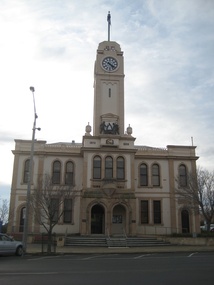 Victorian Interpretive Projects Inc.
Photograph - colour, Clare Gervasoni, Stawell Town Hall, 13/08/2012
... The Stawell Town Hall clock and tower were erected by Mrs Norman Kelly in memory of her late father Cr George Barnes, a councillor of the Borough of Stawell over a period of 47 years, and also her mother, the late Emma Barnes. 10 May 1939. ...The Stawell Town Hall clock and tower were erected by Mrs Norman Kelly in memory of her late father Cr George Barnes, a councillor of the Borough of Stawell over a period of 47 years, and also her mother, the late Emma Barnes. 10 May 1939. ...Stawell was known as a gold mining town. The Stawell Town Hall clock and tower were erected by Mrs Norman Kelly in memory of her late father Cr George Barnes, a councillor of the Borough of Stawell over a period of 47 years, and also her mother, the late Emma Barnes. 10 May 1939. The animated mining scene on the Stawell Town Hall was incorporated into the tower from a bequest by Emma Kelly. It was officially opened by Sir Henry Bolte on 06 October 1969.Colour photograph of the Stawell Town Hall, and details such as the mining logo and plaques.stawell, stawell town hall, mining, george barnes, emma barnes, emma kelly, henry bolte -
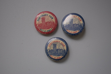 Warrnambool and District Historical Society Inc.
Badges, J.W.Patrick, Christ Church Centenary Fair, Mid 20th century
... The Anglican community in Warrnambool first met in a building in Liebig Street in the early 1850s and in 1856 Christ Church in Henna Street was opened with additions in the 1860s and the tower being erected in 1882. Today Christ Church in Warrnambool still holds an annual fair in late spring....The Anglican community in Warrnambool first met in a building in Liebig Street in the early 1850s and in 1856 Christ Church in Henna Street was opened with additions in the 1860s and the tower being erected in 1882. Today Christ Church in Warrnambool still holds an annual fair in late spring. ...These Christ Church Warrnambool badges were made about the mid 20th century and were either given to church members assisting with the fair held in the church buildings and grounds in the latter part of the year or were sold to community members to raise funds for the church. The Anglican community in Warrnambool first met in a building in Liebig Street in the early 1850s and in 1856 Christ Church in Henna Street was opened with additions in the 1860s and the tower being erected in 1882. Today Christ Church in Warrnambool still holds an annual fair in late spring.These badges are of interest as souvenirs of the fairs held at Christ Church, Warrnambool about the middle of the 20th century..1 A metal badge with blue edging, an image in blue of Christ Church and yellow printing. Around the edge of the badge is information about the badge’s maker. The back of the badge has a metal clip. .2 as above .3 as above except that the colouring is reversed – the edging and image of Christ Church are red and the printing is blue. Centenary Fair Oct.3 – Nov. 1 J.W.Patrick 440 Rae St N. Fitzroy Melb. Vic christ church, warrnmbool, history of warrnambool -
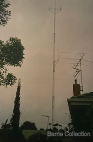 Melton City Libraries
Photograph, Antenna for Mount Cotterill Fire Brigades Group, Unknown
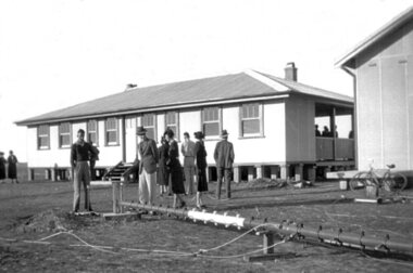
... Erected 1974, dismantled 2000s. The Headquarters was operated from the family home at Ferris road at its inception, and in 1974 to the Barrie home at First Avenue Melton South. A storage office and Radio Tower...Erected 1974, dismantled 2000s. The Headquarters was operated from the family home at Ferris road at its inception, and in 1974 to the Barrie home at First Avenue Melton South. A storage office and Radio Tower ...Erected 1974, dismantled 2000s. The Headquarters was operated from the family home at Ferris road at its inception, and in 1974 to the Barrie home at First Avenue Melton South. A storage office and Radio Tower was erected in the yard. A connection phone line was linked to the home of Wayne and Lynn Sullivan who lived at the rear in Kurrajong Cr later became LY remote. Wayne later became Communications Officer and the Headquarters moved location to the Melton Fire Station. The Mount Cotterill Group encompassed the Rural Fire Brigades of Melton, Rockbank, Sydenham, Toolern Vale, Truganina, and Werribee and later Diggers Rest. In the stage of transition from H.F.( High Frequency) to Very High Frequency some radio sets were non CFA Tankers when the group was established. Antenna was at 19 First Avenue, Melton.emergency services -
 Warrnambool and District Historical Society Inc.
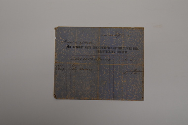
Document - Tower Hill Presbyterian Church Invoice, Committee of Tower Hill Presbyterian Church, 1871
... Tower Hill area as early as 1845. The first permanent minister, Rev. Lachlan McGillivray. was appointed in 1849 and a wooden church was erected at Tower Hill in 1850. ...Tower Hill area as early as 1845. The first permanent minister, Rev. Lachlan McGillivray. was appointed in 1849 and a wooden church was erected at Tower Hill in 1850. ...This is an invoice sent to Messrs W.& J. Hall in September 1871 by the Committee of the Tower Hill Presbyterian Church. It refers to the annual church seat rental fee of three pounds, half of which had been paid in January of that year. The Tower Hill Presbyterian Church was under the auspices of the Koroit Presbyterian Church and services had been held in the Tower Hill area as early as 1845. The first permanent minister, Rev. Lachlan McGillivray. was appointed in 1849 and a wooden church was erected at Tower Hill in 1850. William and James Hall were early farmers in the Tower Hill district.This invoice is of considerable interest as a rare memento of the 19th century Tower Hill Presbyterian Church and a record of the practice of charging an annual fee for a family's use of its own pews in a church.This is a sheet of blue and cream mottled paper with ruled red lines, black printing and handwriting in ink. The sheet is creased, torn at the edges and faded.Messrs W. & J. Hall 30 Sept. 1871 An Account with the Committee of the Tower Hill Presbyterian Churchtower hill presbyterian church, w.& j. hall koroit -
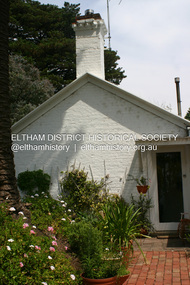 Eltham District Historical Society Inc
Photograph - Digital Photograph, Alan King, Garden Hill, Eltham-Yarra Glen Road, Kangaroo Ground, 3 February 2008
... Son, Robert White was a Councillor of the Shire of Eltham at the time the Shire acquired two acres of land on the adjacent property from the Mess brothers for the creation of the Shire of Eltham Memorial Park (1921) in which the Shire of Eltham War Memoirial tower was erected (1926). Fanny White donated a small section of land from the Garden Hill property to facilitate entry access to the park. ...Son, Robert White was a Councillor of the Shire of Eltham at the time the Shire acquired two acres of land on the adjacent property from the Mess brothers for the creation of the Shire of Eltham Memorial Park (1921) in which the Shire of Eltham War Memoirial tower was erected (1926). Fanny White donated a small section of land from the Garden Hill property to facilitate entry access to the park. ...The original house was built around 1850 was one of Kangaroo Ground's earliest homes, part of which remains today. Built by Scottish farmer Andrew Harkness who acquired the property in 1849 at the top of the hill with magnificent panoramic views as far as Kinglake, the same year he married Sarah Oswin. The property was known as Garden Hill from at least 1865. Andrew and Sarah had four sons and five daughters. Harkness was a founder of the Kangaroo Ground School and one of the first to suggest establishing the Eltham District Road Board (1858-71) of which he was a member, the pre-cursor to the Shire of Eltham (1871-1994). He was also a Trustee of the Kangaroo Ground Cemetery. His daughter Fanny married farmer Alexander White who purchased the property in 1893. Alexander White died in 1906 and ownership transferred to Fanny White. Son, Robert White was a Councillor of the Shire of Eltham at the time the Shire acquired two acres of land on the adjacent property from the Mess brothers for the creation of the Shire of Eltham Memorial Park (1921) in which the Shire of Eltham War Memoirial tower was erected (1926). Fanny White donated a small section of land from the Garden Hill property to facilitate entry access to the park. The White family sold the property to Sir Herbert Gepp in 1925. Covered under Heritage Overlay, Nillumbik Planning Scheme. Published: Nillumbik Now and Then / Marguerite Marshall 2008; photographs Alan King with Marguerite Marshall.; p29This collection of almost 130 photos about places and people within the Shire of Nillumbik, an urban and rural municipality in Melbourne's north, contributes to an understanding of the history of the Shire. Published in 2008 immediately prior to the Black Saturday bushfires of February 7, 2009, it documents sites that were impacted, and in some cases destroyed by the fires. It includes photographs taken especially for the publication, creating a unique time capsule representing the Shire in the early 21st century. It remains the most recent comprehenesive publication devoted to the Shire's history connecting local residents to the past. nillumbik now and then (marshall-king) collection, kangaroo ground -
Bendigo Historical Society Inc.
Legal record - George Lansell's Fortuna Renovations, 1875
... For eplumbing work in Mrs Lansell's Billiard Room 1893 11217.83g plans and notes on the additions and alterations Nov 1890 11217.83h Plans from Vahland and Getzschmann for front elevation of the buiding 1875 11217.83i Tender 03 July 1871 by R.A. Love to erect a tower at Fortuna, includes plans...For eplumbing work in Mrs Lansell's Billiard Room 1893 11217.83g plans and notes on the additions and alterations Nov 1890 11217.83h Plans from Vahland and Getzschmann for front elevation of the buiding 1875 11217.83i Tender 03 July 1871 by R.A. Love to erect a tower at Fortuna, includes plans Legal record George Lansell's Fortuna Renovations ...Emil Mauermann, from Hainewalde in the south-east of Saxony, worked in Bendigo from 1886 to 1894, initially working for Vahland before establishing his own architecture office in 1887. Later he and his German wife moved to Western Australia, where he worked for many years. It is thought likely that he had a significant influence on Vahland’s design for the Colonial Bank in View Street. Many German immigrant architects worked in Bendigo in the 19th century, e.g. Mauermann, Nicolai, Bosselmann and Lehmann, but the two biggest names are Carl Wilhelm Vahland and Robert Getzschmann, who had a considerable effect on the appearance of Bendigo. Vahland was trained as an architect at the Baugewerkschule (School of Building) at Holzminden on the River Weser, not far from his hometown of Nienburg, also on the Weser. Vahland came from a family of builders. At 27, not long after completing his studies, he emigrated to Australia, arriving in Melbourne in September 1854 on the San Francisco. He went to the Bendigo goldfields but had no luck finding gold. For a while he built gold-washing cradles for the alluvial diggers and then started his Australian architectural career which lasted nearly 50 years. Robert Getzschmann, another German, had arrived in Victoria in 1849 and moved to Bendigo in 1857. In 1858 Vahland and Getzschmann established a partnership and opened an architectural office in Pall Mall, Bendigo. This partnership of Vahland and Getzschmann designed many churches, banks, schools, hotels, theatres and private homes in Bendigo, and designed buildings in a wide surrounding area, reaching up into southern NSWLegal Records of George Lansell's Fortuna This item contains the following documents: 11217.83a Legal Records of George Lansell's Fortuna - Contract with L. Mauermann, Architect for Alterations and additions of a mansard story to the private residence of George Lansell's esq, Sandhurst. A mansard roof is a distinctive, multi-sided roof with two distinct slopes on each side. Icludes notes and plans of the additions to the building 11217.83b General Terms and Condition form W. Beebe, Architect, Mitchell Street , Bendigo. For carpenters work in Mrs Lansell's Billiard Room 11217.83c Plans from Vahland and Getzschmann for doors, windows and the staircase 11217.83d General Terms and Condition form W. Beebe, Architect, Mitchell Street , Bendigo. For excavations, brick, stone and concrete work in Mrs Lansell's Billiard Room 11217.83e General Terms and Condition form W. Beebe, Architect, Mitchell Street , Bendigo. For concrete work in Mrs Lansell's Billiard Room 11217.83f General Terms and Condition form W. Beebe, Architect, Mitchell Street , Bendigo. For eplumbing work in Mrs Lansell's Billiard Room 1893 11217.83g plans and notes on the additions and alterations Nov 1890 11217.83h Plans from Vahland and Getzschmann for front elevation of the buiding 1875 11217.83i Tender 03 July 1871 by R.A. Love to erect a tower at Fortuna, includes plansnon-fictionbendigo, fortuna, george lansell, fortuna alterations -
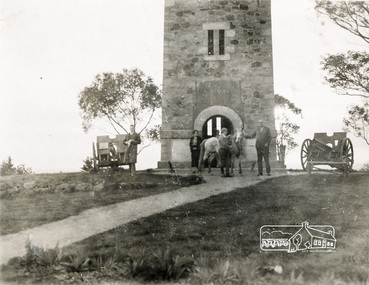 Eltham District Historical Society Inc
Photograph, Memorial Tower, Kangaroo Ground c.1934, 1934c
... They were planted in August 1926, with all the plantings paid for, and done, by the public as the Tower was being erected. The two field guns have been identified as of German origin, Krupp 77 mm calibre captured on October 4, 1918 at Geneve, France. ...They were planted in August 1926, with all the plantings paid for, and done, by the public as the Tower was being erected. The two field guns have been identified as of German origin, Krupp 77 mm calibre captured on October 4, 1918 at Geneve, France. ...Sepia photograph of Joyce McMahon and 'Tiny' Carroll at the War Memorial Tower, Kangaroo Ground c.1934. The guns were installed in 1934 and removed in 1942. Taken in the early 1930s, the photograph ... shows the Kangaroo Ground Tower of Remembance with Joyce McMahon, daughter-in-law of Mr. P. J.McMahon, the then Shire of Eltham Secretary, her horse and a very tall person patting the horse. He is ex-serviceman W. "Tiny" Caroll who was the council's caretaker of the surrounding War Memorial Park. He lived in the stone cottage which still stands in the park. "Tiny" is seen as the fictional character "Tiny Bourke" who, in author Alan Marshall's book "This is the Grass", "was a giant of a man, well over six feet high, with huge hands that completely encircled the cup of tea". The bronze casting, which shows the 79 names of those who paid the "supremen sacrifice" in World War 1 (1914-1918), was erecfed above the entrance to the Tower in September, 1930. The Monterey cypress trees which now form the windbreak around the park's fenceline, were just knee high in this photograph. They were planted in August 1926, with all the plantings paid for, and done, by the public as the Tower was being erected. The two field guns have been identified as of German origin, Krupp 77 mm calibre captured on October 4, 1918 at Geneve, France. They were removed in 1943/44 as a wartime requirement of the Australian Govenment. A public notice dated October 16, 1926 by Cr. H Rutter, Chairman of the Eltham Soldiers War Memorial League stated: "On the summit of that central and conspicuous landmark, Garden Hill, there is being erected a massive memorial tower which will, for all time, remind every passerby of the part played by the men of the Shire of Eltham in the Great War. The work has been undertaken by the people of the Shire a a tribute of love and admiration for those who were known and dear to use in the days of their youth and early manhood, who went out from amongst us, never to return, and whose self-sacrifice has made us, each and all, thier ever-lasting debtors" Harry Gilham, Eltham District Historical Society Kangaroo Ground Tower of Remembrance, A Journey in Time: a column about Nillumbik's history, Nillumbik Mail, 9th August, 2000 Since that research the following has been sourced from Eltham and Whittlesea Shires Advertiser and Diamond Creek Valley Advocate, April 8, 1921, p. 3 Retrieved April 25, 2020, from http://nla.gov.au/nla.news-article57639687 Eltham Shire Council From Town Clerk, Melbourne, stating that a light machine-gun captured by the 22nd battalion, A.I.F. at La Motte Farm, near Beaurvoir, on Oct. 3rd, 1918, during the operations which won the Beauvoir line and completed the smashing of the great Hindenburg defence-system, has been alloted to the Shire of Eltham. - On the motion of Crs Hubbard and Smedley, it was decided to have the gun placed in the Memorial Park. Sepia Photographgarden hill, gun, joyce mcmahon, kangaroo ground, memorial tower, shire of eltham war memorial tower, tiny carroll, war memorials, war trophy, william carroll -
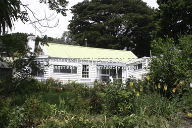 Eltham District Historical Society Inc
Photograph - Digital Photograph, Alan King, Garden Hill, Eltham-Yarra Glen Road, Kangaroo Ground, 3 February 2008
... Son, Robert White was a Councillor of the Shire of Eltham at the time the Shire acquired two acres of land on the adjacent property from the Mess brothers for the creation of the Shire of Eltham Memorial Park (1921) in which the Shire of Eltham War Memoirial tower was erected (1926). Fanny White donated a small section of land from the Garden Hill property to facilitate entry access to the park. ...Son, Robert White was a Councillor of the Shire of Eltham at the time the Shire acquired two acres of land on the adjacent property from the Mess brothers for the creation of the Shire of Eltham Memorial Park (1921) in which the Shire of Eltham War Memoirial tower was erected (1926). Fanny White donated a small section of land from the Garden Hill property to facilitate entry access to the park. ...The original house was built around 1850 was one of Kangaroo Ground's earliest homes, part of which remains today. Built by Scottish farmer Andrew Harkness who acquired the property in 1849 at the top of the hill with magnificent panoramic views as far as Kinglake, the same year he married Sarah Oswin. The property was known as Garden Hill from at least 1865. Andrew and Sarah had four sons and five daughters. Harkness was a founder of the Kangaroo Ground School and one of the first to suggest establishing the Eltham District Road Board (1858-71) of which he was a member, the pre-cursor to the Shire of Eltham (1871-1994). He was also a Trustee of the Kangaroo Ground Cemetery. His daughter Fanny married farmer Alexander White who purchased the property in 1893. Alexander White died in 1906 and ownership transferred to Fanny White. Son, Robert White was a Councillor of the Shire of Eltham at the time the Shire acquired two acres of land on the adjacent property from the Mess brothers for the creation of the Shire of Eltham Memorial Park (1921) in which the Shire of Eltham War Memoirial tower was erected (1926). Fanny White donated a small section of land from the Garden Hill property to facilitate entry access to the park. The White family sold the property to Sir Herbert Gepp in 1925. Covered under Heritage Overlay, Nillumbik Planning Scheme. Published: Nillumbik Now and Then / Marguerite Marshall 2008; photographs Alan King with Marguerite Marshall.; p29 Garden Hill, on Yarra Glen Road, Kangaroo Ground, near the War Memorial is well named. The old house and gardens overlook a magnificent panorama extending to Kinglake. The original house, built around 1850, was one of Kangaroo Ground’s earliest, and part of it remains in today’s timber house. The house was built by the early and prominent settler Andrew Harkness. Later it was occupied for a long time by Sir Herbert Gepp, renowned Australia wide.1 Harkness and Gepp are buried in the Kangaroo Ground Cemetery. Scottish farmer Harkness, who was born in 1817, acquired this property in 18492 and he and his family occupied it until the early 1920s. Harkness cleared its 152 acres (61.4 ha), fenced it and grazed sheep and cattle. Harkness proved a valuable community member. When only ten families lived in the district, he and other settlers set up a school in 1852, with Andrew Ross as the first teacher. Harkness was also one of the first to suggest establishing the Eltham District Road Board, of which he was a member for around 15 years. He was also a trustee of the Kangaroo Ground Cemetery. Harkness married in 1854 and had four sons and five daughters. The first part of the timber house he built included a kitchen-living room and a parlor. The living room’s large fireplace was bricked-in and modernised in 1940. Beside it is the old baker’s oven with its original iron door replaced by a wooden one. It is thought two wattle-and-daub huts, used for a bedroom and bathroom, were built to the west. Harkness’ son-in-law, farmer Alexander White, who had seven sons, bought the property in 1893. Harkness’ grand-daughter Flora married Ewen Cameron who became Minister for Health and was later knighted; he was not related to Ewen Hugh Cameron, a Member of the Legislative Assembly. In 1923 the White family sold the property, called Kilby Park, to Sir Herbert Gepp, who renamed it Garden Hill. Gepp used the property, which was still on the original New South Wales title, as a hobby farm. Robert White stayed on to manage the farm for a while, living in a house on the property. Gepp was born in 1877 and at 16 years began working as a junior chemist with the Australian Explosives and Chemical Company at Deer Park near Melbourne. Gepp was a pioneer in applying enlightened labour policies in industry. He initiated the Broken Hill Progress Association, to improve living conditions. It laid the ground work for the welfare schemes pursued by companies after World War One. During the mid 20th century Gepp was the most prominent liberal thinker associated with conservative politics. As a friend of Prime Minister John Curtin, he contributed to post-war reconstruction. Gepp returned to private industry and retired in 1950. Gepp made significant contributions to the solution of the great metallurgical problems of the mining industry. He was an advocate of the role of science in industry, government and the economy and helped to establish several organizations including the CSIR and the Institute of Public Affairs.3 After Sir Herbert died in 1954 his son Orwell continued to farm the property part-time. When Lady Gepp died in 1963, the land was divided among the five children, although Orwell continued to farm it as a hobby. In 1966, a daughter, Mardi Gething, now married, settled in the house. Another daughter, Kathleen, built her house close by on the property. After the Board of Works designated the property as part of a reserve for a possible reservoir, the family sold all, except the minimum 20 acres allowed, to the Board in the 1970s. Orwell then leased what was the family property from the Board to continue grazing. The two sisters and brother continued to live on the property.This collection of almost 130 photos about places and people within the Shire of Nillumbik, an urban and rural municipality in Melbourne's north, contributes to an understanding of the history of the Shire. Published in 2008 immediately prior to the Black Saturday bushfires of February 7, 2009, it documents sites that were impacted, and in some cases destroyed by the fires. It includes photographs taken especially for the publication, creating a unique time capsule representing the Shire in the early 21st century. It remains the most recent comprehenesive publication devoted to the Shire's history connecting local residents to the past. nillumbik now and then (marshall-king) collection, kangaroo ground -
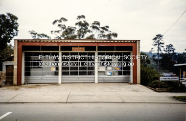 Eltham District Historical Society Inc
Photograph, Eltham Fire Station, 909 Main Road, Eltham, July 1986
... The station was officially opened April 26, 1935, and a new 35 feet high bell tower was erected in December 1935. This fire station, the third erected in six years, served the community for the next thirty years. ...The station was officially opened April 26, 1935, and a new 35 feet high bell tower was erected in December 1935. This fire station, the third erected in six years, served the community for the next thirty years. ...Located at 909 Main Road, Eltham. Opened 7 October 1966 Eltham's Fire Stations by Peter Pidgeon Article published EDHS Newsletter No.287 April 2026 Where was Eltham’s first fire station and how many have there been? Following the formation of the Eltham Volunteer Fire Brigade in March 1926, firefighting equipment was initially housed in a shed on Captain H. Warren’s property. A more permanent solution was required. In May 1927 a proposal was made to build a fire station and meeting hall at the corner of Luck Street and Main Road where the present railway station carpark is located. An application was approved by Council in September to build the fire station consisting of a galvanised iron shed on the land in Luck Street, However, in April 1928 when E.O. Egan, Secretary, Eltham Volunteer Fire Brigade sought permission to erect a fire station on the continuation of Luck Street, Council advised they had no power to act on this as they did not own the land. Cr. Ernie Andrew offered to loan a site on his own land in Arthur Street (where the entrance to the carpark under Woolworths is situated) and by September 1928 the new fire station was being erected consisting of a building to house the reel and other equipment as well as a meeting room. It was constructed with a concrete floor and painted. A purpose-built cupboard had been constructed for the hose by local carpenter, Mr. Fraser and Mr. Frank Jones arranged for electric lighting to be installed. Many donations were made by the community to assist in paying off the debt on the station. The first meeting in the new fire station was held November 12, 1928, with a large attendance of members. The official opening was to be held in the New Year on January 8, 1929. In February 1930, Eltham Council agreed to place the Eltham Volunteer Fire Brigade under the control of the Country Fire Brigades’ Board. Further discussions were held in May regarding their area of responsibility to cover as well as questions about a suitable block of land and relocation of the brigade’s buildings. In August 1930, the Chief Officer of Country Fire Board visited Council to select a suitable site. He did not approve of any that Council suggested but encouraged Council to buy land for the purpose. Enquiries were made about a block in Henry Street adjacent to the Public Hall which the Chief Officer favoured. Cr Price investigated and learned the block could be purchased, £10 would secure it if the people of Eltham were willing to raise a further £30-40. All were in favour of proceeding. By February 1931, £40 had been raised by the community, in addition to £20 added by Council and £20 by the Fire Brigades’ Board making £80 total to purchase the site. Several working bees were held between May and July 1931 to level the ground in preparation for relocation of the station building from Arthur Street to the new site in Henry Street. It was not long before the Henry Street site had proven to be not all that was desired. Access to the Henry Street site from Main Road was steep and not suited for man handling a heavy hose reel. By November 1933 the Country Fire Brigades’ Board advised it was considering the matter of a new cation and fire station for Eltham. On February 23, 1934, the Advertiser reported a new Fire Station was to be built on an alternate site at a cost of £600. In August, the Country Fire Brigades’ Board notified it intended to build a new fire station at no cost to Eltham if the brigade could purchase a block of land. An appeal was established by the brigade to raise funds for the purchase of the new site between the residence and confectionery shop owned by Mr. G.H. Browne and Ryan Bros. butchers on the eastern side of Main Road between Arthur and Dudley streets. An inspection of the site by the Chief Officer of Country Fire Brigades' Board was undertaken September 28. It was directed that tenders for the erection of the building were to be called immediately and construction to start the next month. By New Year 1935 the erection of the third station building was well in progress and was completed by mid-February. The station was officially opened April 26, 1935, and a new 35 feet high bell tower was erected in December 1935. This fire station, the third erected in six years, served the community for the next thirty years. In 1962, land for a new (fourth) Eltham Fire Station on the opposite (western) side of Main Road was acquired from the Eltham War Memorial Trust. The new station was opened October 7, 1966. In 1970 the former fire station building on the eastern side of Main Road was relocated to Research Park for use by the 1st Research Scout group. The site is now part of the current Coles supermarket and Eltham Village complex. A new fifth fire station was erected in Brougham Street at a cost of $9.6m and officially opened December 2015. It was intended for use by both career and volunteer firefighters. The former site was to be made available for community access. However, the mixed functional role presented operational difficulties at the new station and after three years, the Eltham CFA volunteers moved back to the former site towards the end of 2018 following a $500,000 upgrade to the facility. So nowadays the career Fire Rescue Victoria members of Eltham Fire Brigade operate out of Eltham’s fifth fire station in Brougham Street and the volunteer Eltham CFA Brigade operate out of Eltham’s fourth station, or could it be considered the sixth?Colour photograph of Eltham Fire Station, Main Road, July 1986eltham fire brigade, eltham fire station, eltham shops, main road eltham -
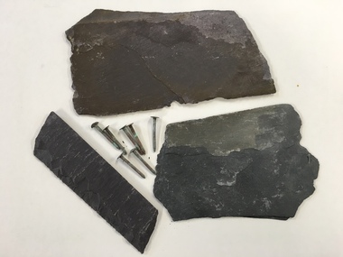 Warrnambool and District Historical Society Inc.
Building Marerial, Slate & Nails, mid 19th century
... The chancel was erected in 1877 and the tower completed in 1882. The church is a stone building. ...The chancel was erected in 1877 and the tower completed in 1882. The church is a stone building. ...These slates and nails were recovered from the roof of Christ Church, Warrnambool when the slates were replaced recently. The foundations of the Anglican Christ Church in Warrnambool were laid in 1855 in Henna Street. The south nave was completed in 1857, a porch was added in 1859 and in 1862 the north nave was completed. The chancel was erected in 1877 and the tower completed in 1882. The church is a stone building. The Hammond Centre for community functions was added in the early 21st century. These items are of interest as they demonstrate the type of building materials used in the 19th century. They are also of interest as they come from a prominent building in Warrnambool, the Anglican Christ Church.These are three irregular-shaped pieces of grey slate and seven iron nails from the slate roof of Christ Church, Warrnambool. The nails have a round head and are slightly rusted. christ church warrnambool, history of warrnambool -
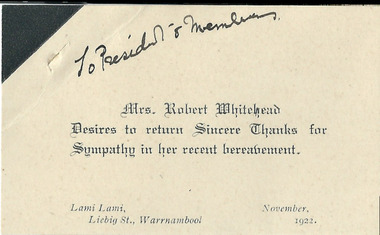 Warrnambool and District Historical Society Inc.
Document, Bereavement Whitehead, 1922
... erected in 1877. The deceased Robert Whitehead was born in 1848 at Goodwood, Caramut and was a pastoralist. His second wife was Myrtle McFarland. Robert Whitehead is buried in the Tower...erected in 1877. The deceased Robert Whitehead was born in 1848 at Goodwood, Caramut and was a pastoralist. His second wife was Myrtle McFarland. Robert Whitehead is buried in the Tower ...This is a card sent by Mrs Whitehead in 1922 thanking the Warrnambool Club members for their sympathy following the death of Robert Whitehead. The Warrnambool Club was established in 1873 as a gentlemen’s club and the Warrnambool Club building which still stands today in Kepler Street was erected in 1877. The deceased Robert Whitehead was born in 1848 at Goodwood, Caramut and was a pastoralist. His second wife was Myrtle McFarland. Robert Whitehead is buried in the Tower Hill Cemetery.This card is of interest as it has a social history showing the type of bereavement card used in the 1920s – a plain card with a black edging. These cards could be purchased in bulk with a blank sheet for inserting the relevant details. The connection with the Warrnambool Club and Robert Whitehead is also of interest.This is a cream-coloured card with a black edge at the top left hand corner. It has handwritten and printed material. It has a small slit on the left hand corner indicating it has been pinned to a wall or noticeboard.‘To President & Members’ ‘Mrs Robert Whitehead desires to return sincere thanks for sympathy in her recent bereavement’ ‘Lami Lami, Liebig Street, Warrnambool, November 1922’ robert whitehead, warrnambool club, warrnambool, goodwood caramut -
Christ Church Anglican Parish of Warrnambool
Memorial Plaque: Frederick Stephen STEVENS, CG Roeszler Sc Melbourne; WJ Hickford Warrnambool, Late 19th Century
... The Three Bells erected / in this Tower were / presented to Christ Church warrnambool by FP Stevens / Member for Villiers & Heytesbury / of the Legislative Council of / Victoria 1852 / In Memory of his younger Son / FS Stevens who died at his Station / Tintinchilla Queensland / 26th May 1880 Aged 30 Years...The plaque acknowledges the loss of a son, the provision of the three bells and the status of the donor. fp stevens fs stevens german bells german bells melbourne exhibition 1881 The Three Bells erected / in this Tower were / presented to Christ Church warrnambool by FP Stevens / Member for Villiers & Heytesbury / of the Legislative Council of / Victoria 1852 / In Memory of his younger Son / FS Stevens who died at his Station / Tintinchilla Queensland / 26th May 1880 Aged 30 Years Ornately decorated, coloured and inscribed brass plaque within an oak frame. ...The bells presented to Christ Church were brought to Melbourne for the 1881 Melbourne Exhibition where they were awarded 1st prize. Frederick Perkins Stevens several years later also provided the three stained glass windows above the main altar within the church as a memorial to his first wife, Jane, FS Stevens' mother.The plaque acknowledges the loss of a son, the provision of the three bells and the status of the donor.Ornately decorated, coloured and inscribed brass plaque within an oak frame. Red and blue colouring within the design elements and lettering.The Three Bells erected / in this Tower were / presented to Christ Church warrnambool by FP Stevens / Member for Villiers & Heytesbury / of the Legislative Council of / Victoria 1852 / In Memory of his younger Son / FS Stevens who died at his Station / Tintinchilla Queensland / 26th May 1880 Aged 30 Yearsfp stevens, fs stevens, german bells, german bells melbourne exhibition 1881 -
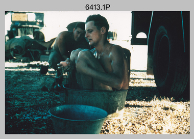 Bendigo Military Museum
Photograph - Royal Australian Survey Corps Surveyors in the Field – North Queensland, 1958
... tower. L to R: John Van De Graff, Bob Skitch, Kev Moody, Mal Hayes, Don Gray .5) - Photo, colour, 1958. Surveyors south of Richmond, QLD erecting a Bilby observation tower. ...tower. L to R: John Van De Graff, Bob Skitch, Kev Moody, Mal Hayes, Don Gray .5) - Photo, colour, 1958. Surveyors south of Richmond, QLD erecting a Bilby observation tower. ...This is a set of seven photographs of surveyors and support staff in the field undertaking duties in North Queensland in 1958. The surveyors were employed in the establishment of mapping and geodetic control. In this era surveyors used theodolites to observe horizontal and vertical angles and chains to measure base line distances between survey stations. Bob Skitch shown in photos .4P to .6P was in the 2nd year of his career in the Australian Army. He achieved the rank of Lieutenant Colonel and his last appointment was the CO of the Army Survey Regiment from 1976 to 1980. The annotation on the back of photo .5P ‘Black foreground is where Bob Skitch boiled billy and started a grass fire’.This is a set of seven photographs of surveyors and support staff in the field undertaking duties in North Queensland in 1958. The photographs were printed on photographic paper and are part of the Army Survey Regiment’s Collection. The photographs were scanned at 300 dpi. .1) - Photo, colour, 1958. Surveyor in Nth QLD enjoying a bath. L to R: Don Cocker, Bob Thompson. .2) - Photo, colour, 1958. Don Cocker surveyor in Nth QLD, enjoying a bath. .3) - Photo, colour, 1958. Surveyors Nth QLD undertaking survey observations, using MRA1 tellurometer to measure base-line distances. L to R: Len Davies, Lou Sommer, John Van De Graff. MRA1 was covered to stop overheating. .4) - Photo, colour, 1958. Surveyors south of Richmond, QLD digging holes for the erection of a Bilby observation tower. L to R: John Van De Graff, Bob Skitch, Kev Moody, Mal Hayes, Don Gray .5) - Photo, colour, 1958. Surveyors south of Richmond, QLD erecting a Bilby observation tower. L to R: Tom Royle, Bob Skitch (on ground level), Mal Hayes. .6) - Photo, colour, 1958. Surveyors south of Richmond, QLD erecting a Bilby observation tower. L to R: Tom Royle, Bob Skitch, Mal Hayes, Jim McGill (on ground level). .7) - Photo, colour, 1958. Surveyors south of Richmond, QLD undertaking survey measurements from a Bilby observation tower..1P to .7P annotated on back – personnel names, the year and the location. Annotated on back of .5P ‘Black foreground is where Bob Skitch boiled billy and started a grass fire’.royal australian survey corps, rasvy, army survey regiment, asr, army svy regt, fortuna, surveying -
 Bendigo Military Museum
Photograph - Royal Australian Survey Corps Survey Observation Towers, c1950s
... The Bilby Tower seen in photo .5P was erected to a height of 75 feet (23m) above ground level. ...The photographs were scanned at 300 dpi. .1) - Photo, black & white, c1950s, ‘Bilby’ survey observation tower. .2) - Photo, black & white, c1950s, CAPT George Ricketts climbing ‘Bilby’ survey observation tower. .3) - Photo, black & white, c1950s, geodetic survey equipment on ‘Bilby’ survey observation tower. .4) - Photo, black & white, c1950s, two unidentified field surveyors on ‘Bilby’ survey observation tower. .5) - Photo, black & white, c1950s, two unidentified field surveyors, with CAPT Ricketts climbing ‘Bilby’ survey observation tower. .6) - Photo, black & white, c1950s, two unidentified field surveyors undertaking observations on survey observation tower. .7) - Photo, black & white, c1950, two unidentified field surveyors erecting or dismantling a survey observation tower....The Bilby Tower seen in photo .5P was erected to a height of 75 feet (23m) above ground level. ...This is a set of seven photographs of Royal Australian Survey Corps surveyors setting up observation towers in the field and undertaking survey observations during mapping and geodetic control operations. c1950s. Survey observation towers were used mainly to take angular measurements in flat or heavily forested terrain, where height was necessary to achieve observer’s line-of-sight between field survey station. The Bilby Tower seen in photo .5P was erected to a height of 75 feet (23m) above ground level. The use of the Bilby Tower in Topographic Squadron’s field survey operations from 1955 to 1966 is described in page 54 of Valerie Lovejoy’s book 'Mapmakers of Fortuna – A history of the Army Survey Regiment’ ISBN: 0-646-42120-4. CAPT George Ricketts’ period of service was from 1942 to 1976 reaching the rank of LTCOL. It is noted in page 35 of Valerie Lovejoy’s book that then SGT Ricketts hand lettering skills came to the fore from his contribution to the draughting of one of the Japan’s Instruments of Surrender in 1945.This is a set of seven photographs of Royal Australian Survey Corps surveyors setting up observation towers in the field and undertaking survey observations during mapping and geodetic control operations. c1950s. The photographs were printed on photographic paper and are part of the Army Survey Regiment’s Collection. The photographs were scanned at 300 dpi. .1) - Photo, black & white, c1950s, ‘Bilby’ survey observation tower. .2) - Photo, black & white, c1950s, CAPT George Ricketts climbing ‘Bilby’ survey observation tower. .3) - Photo, black & white, c1950s, geodetic survey equipment on ‘Bilby’ survey observation tower. .4) - Photo, black & white, c1950s, two unidentified field surveyors on ‘Bilby’ survey observation tower. .5) - Photo, black & white, c1950s, two unidentified field surveyors, with CAPT Ricketts climbing ‘Bilby’ survey observation tower. .6) - Photo, black & white, c1950s, two unidentified field surveyors undertaking observations on survey observation tower. .7) - Photo, black & white, c1950, two unidentified field surveyors erecting or dismantling a survey observation tower..1P with paper tag annotated ‘Bilby Tower’ .4P on back – ‘Bilby Tower’. .5P on back – ‘Survey Observing Tower. Observing tower used for angular measurement in flat country. 75’ high – CAPT Ricketts climbing. .6P, .7P on back. ‘1960s?’royal australian survey corps, rasvy, army survey regiment, army svy regt, fortuna, asr, surveying -
 Kiewa Valley Historical Society
Transmission Line Connector, circa mid to late 1900's
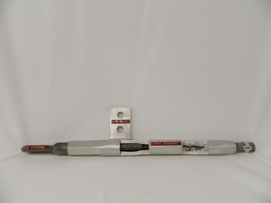
... This line connector tool is part of the erecting of electricity cables from the power stations to the ultimate distribution sub stations throughout Victoria. It is used to extend cable length and secure cable to tower points. ...Kiewa Valley Historical Society Mount Beauty Information Centre 31 Bogong High Plains Rd Mt Beauty high-country This line connector tool is part of the erecting of electricity cables from the power stations to the ultimate distribution sub stations throughout Victoria. It is used to extend cable length and secure cable to tower points. ...This line connector tool is part of the erecting of electricity cables from the power stations to the ultimate distribution sub stations throughout Victoria. It is used to extend cable length and secure cable to tower points. This type of equipment has been in use in this region since power production commenced in the 1950'sThis connection tool is a vital part in the distribution of hydro produced electricity from its mother power plant to its ultimate destination be it rural towns, industry or city. It has been used in the Kiewa valley and its Alpine regions.This power line connection tool was required to extend the length of the power line and is made up from a "compression sleeve" with its connecting lug and at the other end the suspension eye.Stamped on the compression sleeve "4/7/.1297"sec vic kiewa hydro scheme, alternate energy supplies, alpine population growth -
 Nhill Aviation Heritage Centre
Black and white photograph, Local photograph. Original of this scan held by Nhill Historical Society, Aeradio Building c1937
... towers, signalling and meteorology equipment aimed at providing safer navigation for aircraft travelling throughout Australia. The facility closed in the 1960s This photo is significant due to it having been taken soon after the building was constructed. It is the earliest known photograph taken on an open to the public day before the receiver aerials were erected ...This building is still intact at the Nhill Aerodrome. Some of the infrastructure is also in place or can be evidenced by its foundations.The Aeradio building was built on the present aerodrome in 1937. This was one of only sixteen buildings of this type built across Australia and it housed radio communications and guidance equipment. The building and its equipment were part of a comprehensive system of radio towers, signalling and meteorology equipment aimed at providing safer navigation for aircraft travelling throughout Australia. The facility closed in the 1960sThis photo is significant due to it having been taken soon after the building was constructed. It is the earliest known photograph taken on an open to the public day before the receiver aerials were erected.The Aeradio building was built on the present (2012) aerodrome in 1937 or 1938. This was one of only fifteen buildings of this type built across Australia and it housed radio communications and guidance equipment. The building and its equipment were part of a comprehensive system of radio towers lights and signalling equipment aimed at providing safer navigation for aircraft travelling throughout Australia. The facility closed in the 1960sphoto, aeradio, early, civil aviation, dca, dept of civil aviation -
 Eltham District Historical Society Inc
Photograph (Item) - Print, Samantha Robertson, Untitled (Fire Bell), 1988
... Original bell from the first Eltham Fire Station in Arthur Street erected on a tower in November 1928, the station opened in January 1929. ...Eltham District Historical Society Inc 728 Main Rd Eltham melbourne Original bell from the first Eltham Fire Station in Arthur Street erected on a tower in November 1928, the station opened in January 1929. ...Original bell from the first Eltham Fire Station in Arthur Street erected on a tower in November 1928, the station opened in January 1929. In 1988 the bell was mounted beneath a wooden sign of Country Fire Authority, Eltham Fire Station, 909 Main Road, Eltham. As of September 2023 the bell is in the same location, with the signboard gone, suspended in a steel metal tower-like frame. The bell has seen service at the original Eltham Fire Station in Arthur Street (1928-1931), Henry Street beside the Rechabite Hall (1931-1935), Main Road (east side, site of present-day Coles 1935-1965) and 909 Main Road (1965-present). Samantha Robertson 1988 Entrant No. 1 Ref: Series 34 Items 1, 2, 42-45 SHIRE OF ELTHAM COMMUNITY PHOTOGRAPHIC SURVEY Photography is an artform which many of us practice, sometimes purely for artistic pursuit, sometimes to record the people and events in our lives. In 1988, as part of a local Bicentennial project, the Shire of Eltham conducted the Eltham Community Photographic Survey. Up to 100 entries were to be selected by a panel of photographers for entry into the Eltham Photographic Survey Exhibition. Entries had to be submitted by May 13, 1988. Entrants whose images were selected for the exhibition were contacted and requested to further submit an entry form providing entrant’s name, area of residence, age, and proposed captions. These details were then used to produce labels for the exhibition mounts. Where negatives had not been supplied, these were requested to support the display of printed enlargements mounted on 10” x 8” cardboard. The mounted prints were made available post exhibition for sale at $8.50 each for colour prints and $7.00 for B&W prints. Residents in the Shire were invited to collect a free roll of film and take a photograph of what they either liked or did not like about the area. A total of 160 entrants submitted multiple entries for the exhibition. Of those selected for exhibition, entrants ranged in age from 9 to 70 years. All custom colour and black and white printing for the exhibition was completed by Wattle Studios of Eltham. The Eltham Photographic Survey was jointly auspiced by the Shire of Eltham and Wattle Studios, of 953 Main Road, Eltham. The project was greatly assisted by: • David McRitchie, Media Studies Lecturer Victoria College, Rusden Campus. • Ian and Annette Toohill of Wattle Studios • Tracy Naughton, Eltham Community Arts Officer • Neville Emerson Pty. Ltd. • Superior Press, Eltham • Kodak Australasia Pty. Ltd. • Agfa Gevaert Ltd. • Townsend Colourtech Pty. Ltd. • The Australian Bicentennial Authority • Eleanor Bowers, Secretary, Eltham Arts Council The exhibition was placed on display in the Woolworths Arcade, Eltham between Monday June 6th and Saturday June 11, 1988. It was also intended to hold the exhibition at a venue in the Shire’s North Riding from Monday, June 20 to Friday June 24. It was then displayed at the Were Street Theatre, Montmorency from Friday, June 24 to Thursday, July 7. Series 34: Eltham Community Photographic Survey 1988 - Prints & Documentation Series consists of 117 photographs of Shire scenes taken by members of the community. Items I - 41 are larger photographs mounted on card, which were exhibited. Items 42 - 117 are unmounted copies, alternative takes and other entries. Corresponding negatives contained in Series 35: Eltham Community Photographic Survey 1988 – Negatives which consists of 267 colour and B&W negatives and one colour slide of Shire scenes taken by members of the community. The negatives are arranged by the entrant number of the photographer. The Eltham Community Photographic Survey collection is significant to the local community as it was curated by the local community - ordinary people of all ages - representing what they liked and did not like in the area where they lived. It represents an unfiltered representation of the Shire of Eltham as it was in 1988. It also represents one of many projects as part of the national programme of events and celebrations to commemorate the bicentenary. It is a time capsule of life in the 1980s of this urban and rural municipality in Melbourne's north. Front: Entrant No. and name on printed label Rear: Entrant No., name and address on printed label; also 'Series 34' and the 'Item No.' in pencilshire of eltham archives, bicentennial project, country fire authority, eltham, eltham community photographic survey, eltham fire station, eltham photographic survey exhibition, film - ilford xp1 400, fire bell, main road, samantha robertson, scan - 35mm negative, series 34, series 35 -
 Glen Eira Historical Society
Album - Album page, Orrong Road, Circa 1972
... erected for dual use by the Congregationalists and Baptists. In 1894 it was bought by the Congregationalists and continued as a Congregational Church until the formation of the Uniting Church. trevor hart elsternwick congregational church king street orrong road church elsternwick red brick former union church early french gothic style architects george de lacy evans baptist church conical towers houses Handwritten: ELSTERNWICK CONGREGATIONAL CHURCH [under top left photo] / 82 ORRONG ROAD [under top right photo] / 663-1 ORRONG ROAD / SEMI - DETACHED PAIR / 165 [bottom left] Page 165 of Photograph Album with four photographs, two of a church with the other two of houses on Orrong Road. ...This photograph is part of the Caulfield Historical Album 1972. This album was created in approximately 1972 as part of a project by the Caulfield Historical Society to assist in identifying buildings worthy of preservation. The album is related to a Survey the Caulfield Historical Society developed in collaboration with the National Trust of Australia (Victoria) and Caulfield City Council to identify historic buildings within the City of Caulfield that warranted the protection of a National Trust Classification. Principal photographer thought to be Trevor Hart, member of Caulfield Historical Society. Most photographs were taken between 1966-1972 with a small number of photographs being older and from unknown sources. All photographs are black and white except where stated, with 386 photographs over 198 pages. Victorian Heritage Database H0704 FORMER UNION CHURCH 84-86 ORRONG ROAD ELSTERNWICK https://vhd.heritagecouncil.vic.gov.au/places/428 The Former Union Church, Elsternwick, designed by the architect George de Lacy Evans, and erected in 1889-90 is a building of historical and architectural significance for the following reasons:- (1) it is a rare and well- developed example of the early French Gothic manner as popularised through the muscular Victorian re-interpretation of English architect William Burgess, which in turn were derived from the publications of EE Viollet-le-Duc. Other Victorian cases of detailing derived from Viollet-le-Duc include Barwon Park (1868), the Presbyterian Church at Skipton (1871), the Bourke Street West Police Station by Bindley and Brittingham (PWD) dating from 1888-9 and the Lutheran Manse, East Melbourne by JAB Koch (1890). However, none of these buildings relates closely in form to the Union Church, Elsternwick. The only building which has been identified as closely comparable is The Bairnsdale Court House by AJ Macdonald (PWD) which dates from 1892. (2) the use of bright red brickwork is of significance, as the Former Union Church is believed to be only the second church building in Victoria to employ this material as a matter of conscious choice. Amongst red brick churches, it is thought to be preceded only by Reed, Henderson And Smart's Sacred Heart (1884), a Renaissance inspired design. (3) the building is believed to be a rare, possibly unique, surviving example of a church building erected for dual use by the Congregationalists and Baptists. In 1894 it was bought by the Congregationalists and continued as a Congregational Church until the formation of the Uniting Church.Page 165 of Photograph Album with four photographs, two of a church with the other two of houses on Orrong Road.Handwritten: ELSTERNWICK CONGREGATIONAL CHURCH [under top left photo] / 82 ORRONG ROAD [under top right photo] / 663-1 ORRONG ROAD / SEMI - DETACHED PAIR / 165 [bottom left]trevor hart, elsternwick congregational church, king street, orrong road, church, elsternwick, red brick, former union church, early french gothic style, architects, george de lacy evans, baptist church, conical towers, houses