
Showing 64 items matching "emerald township"
-
 Emerald Museum & Nobelius Heritage Park
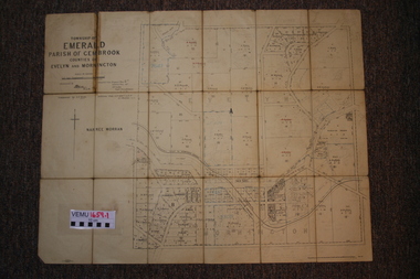
Two maps of Emerald Township 1955 and 1922, Emerald Township
... Two maps of Emerald Township 1955 and 1922...Emerald Township...They are early maps of Emerald Township in 1955 and 1922....VEMU1659.1 Township of Emerald, Parish of Gembrook, Counties of Evelyn and Mornington; September 1955 VEMU1659.2 Township of Emerald, Parish of Gembrook, Counties of Evelyn and Mornington: Drafted 12 Sep 1892, Examined 30 Sep 1892, Additions 17 Jun 1922...They are early maps of Emerald Township in 1955 and 1922. VEMU1659.1 Township of Emerald, Parish of Gembrook, Counties of Evelyn and Mornington; September 1955 VEMU1659.2 Township of Emerald, Parish of Gembrook, Counties of Evelyn and Mornington: Drafted 12 Sep 1892, Examined 30 Sep 1892, Additions 17 Jun 1922 Emerald Township Two maps of Emerald Township 1955 and 1922 ...The Photo Lithographed Maps belonged to George and Mary A'Vard. They are early maps of Emerald Township in 1955 and 1922.VEMU1659.1 Township of Emerald, Parish of Gembrook, Counties of Evelyn and Mornington; September 1955 VEMU1659.2 Township of Emerald, Parish of Gembrook, Counties of Evelyn and Mornington: Drafted 12 Sep 1892, Examined 30 Sep 1892, Additions 17 Jun 1922 -
 Emerald Museum & Nobelius Heritage Park
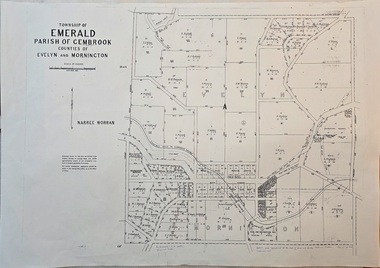
Map - Image of surveyor's map of the Township of Emerald, Surveyors map, Emerald Township 1955, c1955
... Image of surveyor's map of the Township of Emerald...Surveyors map, Emerald Township 1955...Emerald township map c1955...Image of surveyor's map - Township of Emerald 1955...Township of Emerald/parish of Gembrook/Counties of Evelyn & Mornington/By Authority W.M.Huston, Government Printer/Drawn and reproduced at the Dept. of Lands and Survey, Melbourne, Victoria, September 1955...Emerald township map c1955 Township of Emerald/parish of Gembrook/Counties of Evelyn & Mornington/By Authority W.M.Huston, Government Printer/Drawn and reproduced at the Dept. of Lands and Survey, Melbourne, Victoria, September 1955 Image of surveyor's map - Township of Emerald 1955 Surveyors map, Emerald Township 1955 Map Image of surveyor's map of the Township of Emerald ...Emerald township map c1955Image of surveyor's map - Township of Emerald 1955Township of Emerald/parish of Gembrook/Counties of Evelyn & Mornington/By Authority W.M.Huston, Government Printer/Drawn and reproduced at the Dept. of Lands and Survey, Melbourne, Victoria, September 1955 -
 Emerald Museum & Nobelius Heritage Park
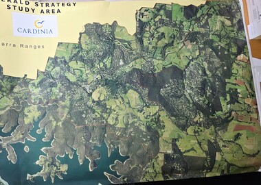
Map - Aerial Colour photographic map of Emerald township and surrounds, Emerald Strategy Study Area (Cardinia), unknown
... Aerial Colour photographic map of Emerald township and surrounds...Aerial photograph of the Emerald township and surrounding area...Image of aerial photograph of the Emerald township and surrounds...Aerial photograph of the Emerald township and surrounding area Emerald Strategy Study Area/Cardinia/Yarra Ranges Image of aerial photograph of the Emerald township and surrounds Emerald Strategy Study Area (Cardinia) Map Aerial Colour photographic map of Emerald township and surrounds ...Aerial photograph of the Emerald township and surrounding areaImage of aerial photograph of the Emerald township and surroundsEmerald Strategy Study Area/Cardinia/Yarra Ranges -
 Emerald Museum & Nobelius Heritage Park
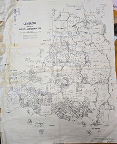
Map - Land Holding map issued by Lands Council Victoria - area south of Emerald township (now mostly under Cardinia Reservoir), Gembrook, Counties of Evelyn & Mornington land holding map 1967, c1967
... Land Holding map issued by Lands Council Victoria - area south of Emerald township (now mostly under Cardinia Reservoir)...land holdings map showing holdings south of the main township of Emerald, much or which is now under the Cardinia Reservoir...Image of land holdings map for area south of Emerald township in the counties of Evelyn & Mornington, Gembrook...JOHNSON (22.8.68)/By Authority AC Brooks, Government Printer, Melbourne/Drawn and reproduced at the Department of Lands and Survey, Melbourne/Price $1.00 per sheet Image of land holdings map for area south of Emerald township in the counties of Evelyn & Mornington, Gembrook Gembrook, Counties of Evelyn & Mornington land holding map 1967 Map Land Holding map issued by Lands Council Victoria - area south of Emerald township (now mostly under Cardinia Reservoir) ...land holdings map showing holdings south of the main township of Emerald, much or which is now under the Cardinia ReservoirImage of land holdings map for area south of Emerald township in the counties of Evelyn & Mornington, GembrookGembrook G206 Sheet/Gembrook counties of Evelyn and Mornington/Compared with originals H.R. JOHNSON (22.8.68)/By Authority AC Brooks, Government Printer, Melbourne/Drawn and reproduced at the Department of Lands and Survey, Melbourne/Price $1.00 per sheet -
 Emerald Museum & Nobelius Heritage Park
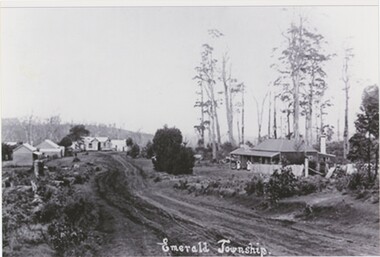
Photograph, Emerald Township, c. 1900s
... Emerald Township...a, b, and c Obverse: "Emerald Township" b Obverse, Printed: "COPIES MAY BE PURCHASED FROM TH" b and c Obverse, in-photo sign (unclear in a): "BUTCHERS" a Reverse: "10 27 EMEF24~1.JPG 5 16.12.06 18.12.06" b Reverse: "J9505398 4/6 00000004.jpg / JOB3819505398 Emerald Old Emerald 2 adjt" c Reverse: "J9505398 1/6 00000001.jpg / JOB3819505398 Emerald early 1.jpg Kevin+"...a is very blurry and a significantly lower quality copy than b or c. Emerald Township Photograph ...The building in the foreground of the image is likely Robert Couper's - Emerald's first butchery which was established in approximately 1900 and later owned by the Madigan family. It was located near the corner of what are now Main Street and Monbulk Road, near today's Madigan Way. If the butchery in the photograph - which was likely taken in the first decade of the twentieth century - is indeed Couper's, this photo is likely looking down Main Street from the intersection with Monbulk Road. These copies were made in 2006.This photograph captures an earlier phase of Emerald's development, not long after the opening of the first Butchery and long before the town had sealed roads.This item includes photographs a, b, and c. The printed black and white photographs depicts an unsealed road, following the centre of the image before curving right over a hill and out of sight. In the background, four wooden structures are present beside the road on the left. In the foreground on the right, another wooden building with a chimney and a metal verandah and roof stands a distance back from the road. In a and c - identical photographs - two distant figures - likely women - stand under the verandah. In b - a slightly different phootgraph from the same angle - a horse and cart is in front of the building with several individuals. Behind the house on the right, trees with sparse leaves rise into the sky, nearly reaching the top of the frame. In the far background on the left, a wooded hill rises above the row of buildings. a is very blurry and a significantly lower quality copy than b or c.a, b, and c Obverse: "Emerald Township" b Obverse, Printed: "COPIES MAY BE PURCHASED FROM TH" b and c Obverse, in-photo sign (unclear in a): "BUTCHERS" a Reverse: "10 27 EMEF24~1.JPG 5 16.12.06 18.12.06" b Reverse: "J9505398 4/6 00000004.jpg / JOB3819505398 Emerald Old Emerald 2 adjt" c Reverse: "J9505398 1/6 00000001.jpg / JOB3819505398 Emerald early 1.jpg Kevin+"emerald, 1900s -
 Emerald Museum & Nobelius Heritage Park
Document - Documents, Emerald Township Development Committee, Emerald towards 2010, Emerald and District Association and Citizens of Emerald vs MMBW, 1989-1993, 1990s
... Documents, Emerald Township Development Committee, Emerald towards 2010, Emerald and District Association and Citizens of Emerald vs MMBW, 1989-1993...1990, Citizens of Emerald vs MMBW, Correspondence and memorandum regarding drainage 5th February 1990, Member of Roads Working Group report and policy 1990-1992, Emerald and District Association, Telephone tree, Rules, Minutes, Correspondence, financial records April 1990, Response to Sherbrooke Shire Council from Emerald Civic Community re 'Emerald towards 2010 report' 20th August 1993, Emerald Medical Centre, Correspondence and lease agreement 1989, Emerald Township, Civic Development Committee, agenda, population data, minutes...Shire of Sherbrooke Victoria Australia Shire of Pakenham Victoria Australia Emerald Civic Committee Documents Correspondence reports 1990, Citizens of Emerald vs MMBW, Correspondence and memorandum regarding drainage 5th February 1990, Member of Roads Working Group report and policy 1990-1992, Emerald and District Association, Telephone tree, Rules, Minutes, Correspondence, financial records April 1990, Response to Sherbrooke Shire Council from Emerald Civic Community re 'Emerald towards 2010 report' 20th August 1993, Emerald Medical Centre, Correspondence and lease agreement 1989, Emerald Township, Civic Development Committee, agenda, population data, minutes Document Documents, Emerald Township Development Committee, Emerald towards 2010, Emerald and District Association and Citizens of Emerald vs MMBW, 1989-1993 ...Minutes, reports, correspondence and notices relating to two resident action groups, the Emerald Civic Committee (1989) and the Emerald and District Association.1990, Citizens of Emerald vs MMBW, Correspondence and memorandum regarding drainage 5th February 1990, Member of Roads Working Group report and policy 1990-1992, Emerald and District Association, Telephone tree, Rules, Minutes, Correspondence, financial records April 1990, Response to Sherbrooke Shire Council from Emerald Civic Community re 'Emerald towards 2010 report' 20th August 1993, Emerald Medical Centre, Correspondence and lease agreement 1989, Emerald Township, Civic Development Committee, agenda, population data, minutesshire of sherbrooke victoria australia, shire of pakenham victoria australia, emerald civic committee, documents, correspondence, reports -
Emerald Museum & Nobelius Heritage Park
Postcard - Emerald Township and Train Station, The Rose Series, 1920s
... Emerald Township and Train Station...Two are of the Emerald township. One is of the Emerald Train Station and one is of cultivated paddocks. ...Two are of the Emerald township. One is of the Emerald Train Station and one is of cultivated paddocks. ...George Rose was one of the pioneers of photographic postcards in Australia. These postcards represent an early period in Emerald history where it was assessed to be of photographic interest for a wider audience.Four black and white postcards from the Rose Series. Two are of the Emerald township. One is of the Emerald Train Station and one is of cultivated paddocks. The Rose Series numbers are: P. 319, P. 1613, P. 1629 and P. 1630 All postcards have handwritten on the back: 'Jan 5th 1923'. The donor informed that the person who had written the dates and presumably the original owner of these postcards was a local resident Tom Currie who had been at the Monbulk High School (?as a student) during 1913 bushfires.Donated by A. M. Currie, relation of Tom Currie who was a local resident.Printed on back of all postcards: Real Photo Post Card / The Rose Series De Luxe Produced in Australia / Published by 'The Rose Stenographs' / Armadale Victoria Handwritten on back: Jan 5th, 1923emerald, victoria, australia, rose series postcard, emerald train station -
 Emerald Museum & Nobelius Heritage Park
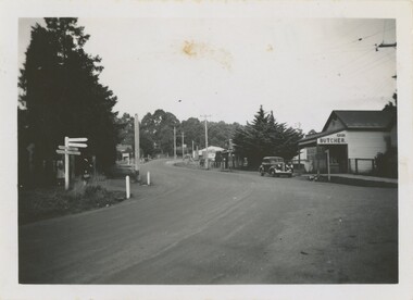
Photograph - Emerald Township 1948, March 1948
... Emerald Township 1948...On the photograph's reverse is some handwritten text. Photograph Emerald Township 1948 ...This particular thoroughfare connecting Belgrave-Gembrook Road and Emerald-Monbulk Road, now home to many local and major business, has changed greatly over the last century. This dirt road was once home to the first Emerald butcher, established by Robert John Couper around 1900. Located on the corner of Main Street and Monbulk Road, the butcher was first run out of Couper's home, then it moved into a shop built on their property and customers were most often served by his wife Mabel. The butcher was then purchased by the Madigan Family in 1924 and run by Timothy James Madigan following his return from World War One service. Animals were slaughtered on-site, then stored in an underground cellar. Meat was then purchased in the store-front or delivered to local towns and homes by horse-drawn carriage and, eventually, delivery vans.This photograph demonstrates with incredible clarity just how greatly the local Emerald township has changed over the last century, especially on a thoroughfare as central as the one pictured.This black and white photograph features a dirt street lined with trees and buildings. On the left, a street sign points to locations such as Lilydale, Monbulk, Gembrook, Ferntree Gully, Macclesfield, and Melbourne. Two women stand behind the sign, waiting to cross the road. A butcher stands on the right side of the street and car is parked out front. Telephone poles are dotted along the road, both disappearing around a corner and into a horizon of trees. On the photograph's reverse is some handwritten text.Rear, handwritten in ink: "Emerald. / Mar. 1948."1940s, emerald, madigan family -
Emerald Museum & Nobelius Heritage Park
Plan - Planning Amendment, Shire of Sherbrooke, 1976
... ...Emerald Township...Shire of Sherbrooke Planning Scheme 1965 Amendment No. 97-1976: Interim development order Emerald Township. Town and Country Planning Act. 1961 Emerald Township. ...Emerald Victoria Australia Shire of Sherbrooke Victoria Australia maps town planning Emerald Township Shire of Sherbrooke Planning Scheme 1965 Amendment No. 97-1976: Interim development order Emerald Township. ...Shire of Sherbrooke Planning Scheme 1965 Amendment No. 97-1976: Interim development order Emerald Township. Town and Country Planning Act. 1961 Emerald Township. Sheets N(28/.0(29/AR(39). Scale 1.7920mPaperemerald, victoria, australia, shire of sherbrooke victoria australia, maps, town planning, emerald township -
Emerald Museum & Nobelius Heritage Park
Map - Survey Map, Department of Lands and Survey, 1948
... Map of area bounded by Monbulk in north and Berwick in the south; includes Emerald township on eastern border and Upwey Station on western border. ...Survey map which includes Emerald Township...Map of area bounded by Monbulk in north and Berwick in the south; includes Emerald township on eastern border and Upwey Station on western border. ...Map of area bounded by Monbulk in north and Berwick in the south; includes Emerald township on eastern border and Upwey Station on western border. Shows land holders.Survey map which includes Emerald Townshipemerald, victoria, australia, land surveys, pioneers, department of lands and survey -
Emerald Museum & Nobelius Heritage Park
Plan - Roundabout Plan, Shire of Sherbrooke, 1989
... ...Emerald Township Roundabouts...Shire of Sherbrooke Emerald Township Roundabouts Belgrave-Gembrook Road and Emerald-Monbulk Road Intersections|Shire of Sherbrooke Emerald Township Roundabouts Belgrave-Gembrook Road and Ferres Road/Kilvington Drive Intersections|Shire of Sherbrooke Emera...Emerald Victoria Australia traffic road construction plans Shire of Sherbrooke Victoria Australia Emerald Township Roundabouts Shire of Sherbrooke Emerald Township Roundabouts Belgrave-Gembrook Road and Emerald-Monbulk Road Intersections|Shire of Sherbrooke Emerald Township Roundabouts Belgrave-Gembrook Road and Ferres Road/Kilvington Drive Intersections|Shire of Sherbrooke Emera Photocopy of plan for roundabouts; Scale 1:200Paper Plan Roundabout Plan Shire of Sherbrooke ...Plans for roundabouts constructed by Shire of Sherbrooke (see Inscriptions for locations) approximately 1990.Photocopy of plan for roundabouts; Scale 1:200PaperShire of Sherbrooke Emerald Township Roundabouts Belgrave-Gembrook Road and Emerald-Monbulk Road Intersections|Shire of Sherbrooke Emerald Township Roundabouts Belgrave-Gembrook Road and Ferres Road/Kilvington Drive Intersections|Shire of Sherbrooke Emeraemerald, victoria, australia, traffic, road construction, plans, shire of sherbrooke victoria australia, emerald township roundabouts -
Emerald Museum & Nobelius Heritage Park
Plan - Surveyor's Plan, Department of Lands and Surveys, 1895
... ...Emerald Township Square Reserve...Plan of Emerald Township Square Reserve, marked out 1859. ...Copy of original surveyor's plan of Township of Emerald, Parish of Gembrook, Counties of Evelyn and Mornington....Plan of Emerald Township Square Reserve, marked out 1859. ...Plan of Emerald Township Square Reserve, marked out 1859. The area was one mile square bounded by Boundary Road, Clematis Park-Telopea Roads, Prince Street, and Sherriff Road. Main roads are shown and large selections as at 1877.The township square was originally named 'Main Range near Emerald Diggings, Parish of Nangana'. Although the building blocks were marked at this time, little interest was taken in the area until 1877.Copy of original surveyor's plan of Township of Emerald, Parish of Gembrook, Counties of Evelyn and Mornington.This map has been prepared from the most reliable data in the possession of the Department up to date of compilation. Information respecting leases or licences which await final completion is not recorded.emerald, victoria, australia, land surveys, maps, emerald township square reserve, main range, department of lands and surveys -
 Emerald Museum & Nobelius Heritage Park
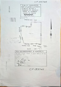
Map - Plan of Consolidation part of Crown Allotments 51 & 10B, Section A, Township of Emerald, Parish of Gembrook, County of Evelyn, Plan of consolidation for government allotment in Emerald, sealed on 19 November, 1984 (Property later to be known as Nobelius Heritage Park, Emerald), c1984
... Plan of Consolidation part of Crown Allotments 51 & 10B, Section A, Township of Emerald, Parish of Gembrook, County of Evelyn...Image of Plan of Consolidation of Crown Allotments in township of Emerald...CP159745, Plan of Consolidation Part of Crown Allotments 51 & 10B Section A, Township of Emerald, Parish of Gembrook, County of Evelyn, area bounded by Emerald Lake Rd., Princess Avenue, Crichton Rd., Kings Avenue. ...Seal and endorsement of municipality - this plan is sealed puRsuant to Section 569AB of the Local Government Act, dated 19th November, 1984, (Property later to be known as Nobelius Heritage Park, Emerald) Image of Plan of Consolidation of Crown Allotments in township of Emerald Plan of consolidation for government allotment in Emerald, sealed on 19 November, 1984 (Property later to be known as Nobelius Heritage Park, Emerald) Map Plan of Consolidation part of Crown Allotments 51 & 10B, Section A, Township of Emerald, Parish of Gembrook, County of Evelyn ...Image of Plan of Consolidation of Crown Allotments in township of Emeraldnon-fiction -
Emerald Museum & Nobelius Heritage Park
Booklet - History Booklet, Legge, G. C
... ...Emerald Township School...History of Emerald State School No. 2110 - 1879-1959, and Emerald Township School No. 3381 (later Emerald) 1901-1965, written by Graeme Legge, a teacher and later deputy principal of Emerald Primary School....History of Emerald State School No. 2110 - 1879-1959, and Emerald Township School No. 3381 (later Emerald) 1901-1965, written by Graeme Legge, a teacher and later deputy principal of Emerald Primary School. ...History of Emerald State School No. 2110 - 1879-1959, and Emerald Township School No. 3381 (later Emerald) 1901-1965, written by Graeme Legge, a teacher and later deputy principal of Emerald Primary School.Emerald State Schools 1879-1965: 86 years - 8pp. booklet: ill.emerald, victoria, australia, schools and colleges, emerald primary school, emerald state school, emerald township school, graeme legge -
Emerald Museum & Nobelius Heritage Park
Map - Township of Emerald, Parish of Gembrook, Counties of Evelyn and Mornington, 6/03/2005 12:00:00 AM
... Township of Emerald, Parish of Gembrook, Counties of Evelyn and Mornington....Township of Emerald, Parish of Gembrook, Counties of Evelyn and Mornington - 1892...Township of Emerald, Parish of Gembrook, Counties of Evelyn and Mornington - 1892 Map Township of Emerald, Parish of Gembrook, Counties of Evelyn and Mornington. ...Township of Emerald, Parish of Gembrook, Counties of Evelyn and Mornington - 1892 -
Emerald Museum & Nobelius Heritage Park
Postcard - Approaching Emerald from Melbourne', 1950s
... On back and front - approaching Emerald township near co-op....Emerald Victoria Australia roads and streets Emerald and District Co-operative Society On back and front - approaching Emerald township near co-op. Black and white postcard and enlarged photocopy Postcard Approaching Emerald from Melbourne' ...Black and white postcard and enlarged photocopyOn back and front - approaching Emerald township near co-op.emerald, victoria, australia, roads and streets, emerald and district co-operative society -
 Emerald Museum & Nobelius Heritage Park
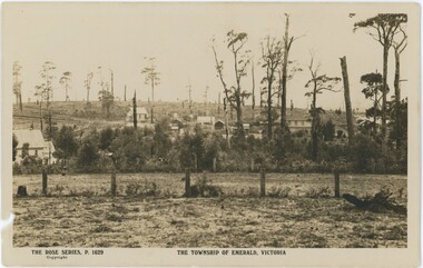
Postcard, Rose Stereograph Company, The Township of Emerald, Victoria, c. 1920s-30s
... The Township of Emerald, Victoria...Obverse: Bottom Left: "THE ROSE SERIES, P. 1629 / Copyright" Bottom Center: "THE TOWNSHIP OF EMERALD, VICTORIA" Reverse: Printed, Top: "REAL PHOTO POST CARD / THE "ROSE" SERIES DE LUXE PRODUCED IN AUSTRALIA" Printed, Left Side: "PUBLISHED BY 'THE ROSE STEREOGRAPHS' / Armadale, Victoria" Handwritten, Center-Left: "NOT EMERALD / - KEVIN HOGAN / - GWEN ASLING / - KEVIN TEASDALE / - CHRIS BRITTON" Handwritten, Stamp Box: "$12"...Printed text below the image introduce the series and location, while the reverse features a medium-sized rose (a midpoint in the evolution of Rose postcards) and printed text but no message written. The Township of Emerald, Victoria Postcard Rose Stereograph Company ...The handwritten names on the reverse of this postcard - Kevin Hogan, Gwen Asling, Kevin Teasdale, and Chris Britton - are all individuals associated with the museum (to varying degrees), seemingly confirming their assessment that this postcard is mistitled and its image is not in fact of Emerald. They were likely correct, indicating that Rose Stereography may have made a mistake. It is difficult to determine how unusual this was; Rose made more than ten thousand postcards, so it is entirely possible some were not checked sufficiently. The reference number P. 1629 was reused at least two more times.While the image on this postcard may not actually be of Emerald, the fact that it is mislabeled as such still tells us about the perception of Emerald at the time of publication - that of a growing rural town amidst hills and trees.This postcard displays a sepia photograph with agricultural space - a field, fences, and trees - in the foreground, and a collection of buildings on a road rising on a hill in the background. Printed text below the image introduce the series and location, while the reverse features a medium-sized rose (a midpoint in the evolution of Rose postcards) and printed text but no message written.Obverse: Bottom Left: "THE ROSE SERIES, P. 1629 / Copyright" Bottom Center: "THE TOWNSHIP OF EMERALD, VICTORIA" Reverse: Printed, Top: "REAL PHOTO POST CARD / THE "ROSE" SERIES DE LUXE PRODUCED IN AUSTRALIA" Printed, Left Side: "PUBLISHED BY 'THE ROSE STEREOGRAPHS' / Armadale, Victoria" Handwritten, Center-Left: "NOT EMERALD / - KEVIN HOGAN / - GWEN ASLING / - KEVIN TEASDALE / - CHRIS BRITTON" Handwritten, Stamp Box: "$12"rose series, emerald -
 Emerald Museum & Nobelius Heritage Park
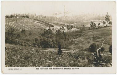
Postcard, Rose Stereograph Company, The View From the Township of Emerald, Victoria, 1920s
... The View From the Township of Emerald, Victoria...Obverse: Lower left: "THE ROSE SERIES, P. 317" Lower centre: "THE VIEW FROM THE TOWNSHIP OF EMERALD, VICTORIA" Reverse: Handwritten annotation, pen: "Looking from Main Rd. / towards Pinnocks Rd. / Nursery in 1920's" Handwritten, pencil, stamp square: "$6" Left: "PUBLISHED BY THE ROSE STEREOGRAPHS / Armadale, Victoria" Upper Centre: "REAL PHOTO POST CARD / THE "ROSE" SERIES DE LUXE PRODUCED IN AUSTRALIA"...The View From the Township of Emerald, Victoria Postcard Rose Stereograph Company ...Several other Rose Stereograph Company postcards of Emerald - including P319 - are listed under VEMUP1031 and were dated Jan 5th 1923, which may have been either a date of purchase or the date the photographs were all taken. If the latter, it is likely this photograph was taken on the same day while the Rose photographer was in town; however, the former is also entirely possible. Regardless, it is likely this photograph is from the 1920s, if not exactly from Jan 5th 1923. The numbers assigned to the photographs are unhelpful for dating them as the Rose company tended to reuse numbers multiple times, and after a while were no longer photographing in numerical order. However, the sepia colour and medium rose is a good indication this is from around the 1920s. It is taken from Emerald Main Street/Belgrave-Gembrook Road, looking towards Pinnocks Road - it is unclear from exactly where on the road it was taken, but it could be looking down over what is now Madigan Way.This photograph records the landscape around Emerald at the start of the 20th century.This item is a sepia postcard. The reverse features a (medium) rose dividing the centre, with printed proprietary text and a small block of handwritten annotation in blue pen. A sale price is marked in pencil, as is an accession number. The obverse has a caption below the image; the image is taken from the top of a hill, looking over a road to rolling hills fading into the background. The first hill on the left has a nursery, growing a range of trees; the other hills are mostly fields with scattered trees.Obverse: Lower left: "THE ROSE SERIES, P. 317" Lower centre: "THE VIEW FROM THE TOWNSHIP OF EMERALD, VICTORIA" Reverse: Handwritten annotation, pen: "Looking from Main Rd. / towards Pinnocks Rd. / Nursery in 1920's" Handwritten, pencil, stamp square: "$6" Left: "PUBLISHED BY THE ROSE STEREOGRAPHS / Armadale, Victoria" Upper Centre: "REAL PHOTO POST CARD / THE "ROSE" SERIES DE LUXE PRODUCED IN AUSTRALIA"1920s, emerald, rose series -
Emerald Museum & Nobelius Heritage Park
Photograph - Store fronts - Emerald, Unknown photographer, 1900s
... ...Emerald Township...Estate agents Emerald Post Office Emerald pharmacy Emerald Township Vintage car motor vehicles Holden HZ Premier Obverse: ESTATE DANDY DOLLAR SAVINGS EMELD PHARMACY / NOBELIUS / ESTATE AGENTS / NOBELIUS & CO. / PTY. ...Further research is required on the right car it is suspected to be a Subaru Brumby. Further research is also needed on the shopfronts shown.This item holds historical significance as it shows several vehicles that are no longer in make as well as how emerald and several of its shop fronts looked in the past. It also holds social significance as these shops would have been a part of how people interacted within the township in the past. All of this is useful; for anyone researching the township or historical cars.Black and white rectangular photograph. The black and white photograph depicts two cars parked in diagonal parking spaces with their drivers standing next to their cars, both on the drivers side of the car. The left car is a Holden HZ Premier wagon, which sits slightly in front of the other car, and also has its driver's side door open. Both vehicles feature luggage racks on their roofs. Behind them, we can seen three different store fronts; Nobelius and Co travel agents, Emerald Post Office, and Emerald Pharmacy.Obverse: ESTATE DANDY DOLLAR SAVINGS EMELD PHARMACY / NOBELIUS / ESTATE AGENTS / NOBELIUS & CO. / PTY. LTD. NOBELIUS & CO. PTY. LTD EMERALD POST OFFICE 3782 Phmacy / AGENT FOR / ANGLE / PARKING / PROPERTY / SALE ESTATE AGENTS / TIONEERS & TRAVEL AGENTS / STATEWIDE / AGENT FOR / NOBELIUS AND CO. / PTY. / LTD. / TRAVEL / BUILD SOCIET / AGENTS / BFK-478 / ANE.666 / VICTORIA /emerald, victoria, australia, nobelius and co., nobelius and co. estate agents, emerald post office, emerald pharmacy, emerald township, vintage car, motor vehicles, holden hz premier -
Emerald Museum & Nobelius Heritage Park
Postcard - Foldout Postcard, Valentine Publishing Co, 1940s
... ...Emerald Township...1940s Emerald Township valentine series postcard Back handwritten greeting " to all from ????? ...Approx 1940s foldout postcard - 9 photos. Front cover features two kittens in a pot with the inscription "A pot full of luck from Emerald". Fold out includes nine black and white views of Emerald. Back handwritten greeting " to all from ????? xx"Back handwritten greeting " to all from ????? xx"1940s, emerald township, valentine series, postcard -
 Emerald Museum & Nobelius Heritage Park
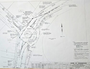
Map - Surveyors Map of new roundabout to be installed at the intersection of Belgrave-Gembrook Rd. and Emerald-Monbulk Rd., Emerald 1989, Shire of Sherbrook, Roundabout at intersection of Belgrave-Gembrook Rd., and Emerald Monbulk Rd., Emerald, drawn 1989 - surveyors map, c1989
... Shire of Sherbrooke/Emerald Township roundabouts Belgrave-Gembrook Rd....Shire of Sherbrooke/Emerald Township roundabouts Belgrave-Gembrook Rd. ...Image of surveyors map outlining dimensions for new roundabout at the intersection of Belgrave-Gembrook Rd., and Emerald-Monbulk Rd. 1989non-fiction -
 Emerald Museum & Nobelius Heritage Park
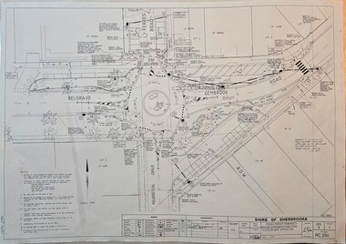
Map - Surveyors Map of new roundabout to be installed at the intersection of Belgrave-Gembrook Rd. and Kilvington Drive, Emerald 1988, Shire of Sherbrook, Roundabout at intersection of Belgrave-Gembrook Rd., and Kilvington Dve., Emerald, drawn 1988 - surveyors map, c1988
... Shire of Sherbrooke/Emerald Township roundabouts Belgrave-Gembrook Rd....Shire of Sherbrooke/Emerald Township roundabouts Belgrave-Gembrook Rd. ...Image of surveyors map outlining dimensions for new roundabout at the intersection of Belgrave-Gembrook Rd., and Kilvington Drive 1988non-fiction -
 Emerald Museum & Nobelius Heritage Park
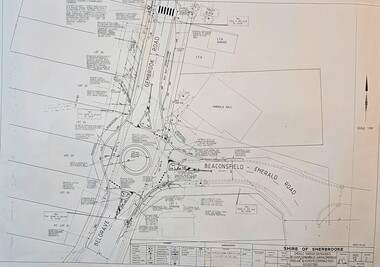
Map - Surveyors Map of new roundabout to be installed at the intersection of Belgrave-Gembrook Rd. and Beaconsfield-Emerald Rd., Emerald 1989, Shire of Sherbrook, Roundabout at intersection of Belgrave-Gembrook Rd., and Beaconsfield-Emerald Rd., Emerald, drawn 1989 - surveyors map, c1989
... Shire of Sherbrooke/Emerald Township roundabouts Belgrave-Gembrook Rd....Shire of Sherbrooke/Emerald Township roundabouts Belgrave-Gembrook Rd. ...Image of surveyors map outlining dimensions for new roundabout at the intersection of Belgrave-Gembrook Rd., and Beaconsfield-Emerald Rd. 1989non-fiction -
Emerald Museum & Nobelius Heritage Park
Postcard - Emerald Landscape, 1942, Rose Stereographs Co, c. 1940s
... The writer, Pops, was staying at the La Belle guesthouse which was located in the centre of the Emerald township....The writer, Pops, was staying at the La Belle guesthouse which was located in the centre of the Emerald township. Postcard Emerald Landscape, 1942 Rose Stereographs Co. ...Guest houses of the DandenongsSepia photographic postcard Rose Series P.1473 Title: A Glorious Panorama Emerald Vic. Postcard of rural and forest landscape in the Emerald area. The text on the reverse is a message to family describing the weather and the location written in December 1942. The writer, Pops, was staying at the La Belle guesthouse which was located in the centre of the Emerald township.Front: The Rose Series Postcard, A Glorious Panorama, Emerald Vic. Back: (handwritten) La Belle, Emerald. 5.12.42. Dear Mum, Here I am at last to tell you that we are both 6. K. & feeling the benefit of the holiday; eating and sleeping better than for considerable time. It rains a good deal up this way, so we have to make the best of the good weather. Was going to ring you today, but was too wet to go to the P. Office. I trust you are keeping well & I will tell you of the place when I return. My kindest regards to Mrs Bryant & trust she is well also. So until next week, cheerio, lots of love. Pops xxx1940s -
Emerald Museum & Nobelius Heritage Park
Plan - Subdivision Plan, Atlas Press, 1911
... Plan of the Benson Estate situated in Emerald Township. Estate agent's notice. Benson selected 20 acres in Emerald Township square. ...Plan of the Benson Estate situated in Emerald Township. Estate agent's notice. Benson selected 20 acres in Emerald Township square. ...Plan of the Benson Estate situated in Emerald Township. Estate agent's notice. Benson selected 20 acres in Emerald Township square. The railway claimed part for Emerald Station. W. Benson lived on the property. Subdivision Crown Lot 5 Parish of Gembrook was put up for auction on the estate on Boxing Day, 26 December 1911 at 1 o'clock. Auctioneer T.W. Butcher, estate agent, lived on railway land adjoining Benson estate. Terms: one-fifth cash, balance two years without interest.Plan of subdivision, mounbted on heavy cardboard.emerald, victoria, australia, land sales, real estate agencies, maps, w. benson, t.w. butcher -
Emerald Museum & Nobelius Heritage Park
Postcard - View from the Main Road Emerald, Rose Stereographs Co, c. 1940s
... The writer, Pops, was staying at the La Belle guesthouse which was located in the centre of the Emerald township....The writer, Pops, was staying at the La Belle guesthouse which was located in the centre of the Emerald township. Postcard View from the Main Road Emerald Rose Stereographs Co. ...Example of tourism interest in the DandenongsSepia photographic postcard Rose Series P.2774 Title: View from the Main Road Emerald Vic Postcard of rural landscape in the Emerald area. The text on the reverse is a message to family describing the weather and the location written in December 1942. The writer, Pops, was staying at the La Belle guesthouse which was located in the centre of the Emerald township.Front: The Rose Series Postcard P.2774. View from the Main Road Emerald Vic Back: Publication details. Post Card Published by Rose Stereograph Co. Armadale Victoria The Rose Series logo A Real Photograph Published in Australia1940s -
Emerald Museum & Nobelius Heritage Park
Memorabilia - Butcher's shop memorabilila
... The original butchers shop was built in the Emerald township by Mr Couper in the early 1900s, then taken over by Mr J. ...The original butchers shop was built in the Emerald township by Mr Couper in the early 1900s, then taken over by Mr J. ...The original butchers shop was built in the Emerald township by Mr Couper in the early 1900s, then taken over by Mr J. Madigan, then by Mr Michael. The shop and adjoining residence located on the corner of Belgrave-Gembrook and Emerald-Monbulk Roads was acquired by the Stephens family in 1948..1988 calendar; typed manuscript; news clippingemerald, victoria, australia, businesses, butchers, calendars, bill stephens, gary stephens, robert couper -
Emerald Museum & Nobelius Heritage Park
Booklet - Local Directory, Universal Business Directories, Who's Who? Directory of Belgrave, Upwey, olinda, Ferntree Gully, Emerald, Germbrook, Cockatoo, Monbulk, 1957-1958
... Includes description of Emerald township and list of businesses in Emerald. ...Includes description of Emerald township and list of businesses in Emerald. ...Printed as an extract from the Victorian Country Trades Directories by Universal Business Directories for circulation within the Dandenong Ranges area. Includes description of Emerald township and list of businesses in Emerald. The population of Emerald at the time was approximately 854. Refer to item for individual and business names.12-page booklet with paper cover printed in red and green. Contents printed in blue. Includes advertisements with illustrations.emerald, victoria, australia, dandenong ranges, victoria, australia, belgrave victoria australia, upwey victoria australia, ferntree gully victoria australia, gembrook victoria australia, cockatoo victoria australia, businesses, banks, bakeries, universal business directories -
Emerald Museum & Nobelius Heritage Park
Photograph - Emerald Primary School, Unknown photographer, 1970s
... ...Emerald Primary School...Township...Lobbying by townspeople in 1899 identified the present location of Emerald School no. 3381, within the original township boundary near the football field. ...The item is significant as it presents a view of Emerald Primary School (Township School no. 3381) in the late 1970s before extensive building works changed the appearance of the school. ...Local farmers and business-owners who settled in Emerald after the initial gold rush period first petitioned for a school in the local area in 1876, with at least two petitions to the Education department lodged by 1877. Emerald School no. 2110 opened as a temporary 'half time' school (meaning that the single teacher split their time between two schools) in temporary facilities in January 1879 while a permanent location was selected. Lobbying by townspeople in 1899 identified the present location of Emerald School no. 3381, within the original township boundary near the football field. The original building constructed to house the school was described variously as 'the tin shed' and 'a hut with a chimney.' It opened in February 1901. The buildings depicted in the photograph show a selection of school buildings and portable classrooms just before major construction works began in late 1977. Five existing portable classrooms were halved in size and moved to a different location before work on a brick wing containing classrooms, an arts and craft room and staff facilities began in early 1978. A 1915 classroom, which may be the building on the left of the image, was modified into administrative offices at the same time. At the time of writing (2023) Emerald Primary School is the largest primary school in the area, with nearly 500 students.The item is significant as it presents a view of Emerald Primary School (Township School no. 3381) in the late 1970s before extensive building works changed the appearance of the school. The tree depicted in the image, a mature Sequoia, or Californian Redwood, was destroyed to build an additional brick wing during these works. Additionally, it is possible that the building on the left-hand side of the image is one of two 1915 classrooms present on the site.Black and white rectangular photograph of the emerald Primary School printed on print media paper. The image depicts the exterior of Emerald Primary School, looking into the school grounds from the street, as it appeared in the late 1970s. In the foreground of the photograph is a gravel path and waist-height chain-link fence. Inside the fence to the left of the image is a large tree and to the right is a sign saying 'Emerald Primary School.' In the background of the photograph are two pale-coloured weatherboard school buildings, one of which has two brick chimneys.Obverse: EMERALD / PRIMARY SCHOOL /1970s, emerald, victoria, australia, emerald primary school, township school no. 3381, township school no. 2110, education, school children, families, sequoia, californian redwood -
Emerald Museum & Nobelius Heritage Park
Photograph - Emerald Primary School, 1979, Unknown photographer, 1979
... ...Emerald Primary School...Township...Lobbying by townspeople in 1899 identified the present location of Emerald School no. 3381, within the original township boundary near the football field. ...Emerald Victoria Australia 1979 1970s Emerald Primary School Township school no. 3381 families school children centenary A.V. ...Local farmers and business-owners who settled in Emerald after the initial gold rush period first petitioned for a school in the local area in 1876, with at least two petitions to the Education department lodged by 1877. Emerald School no. 2110 opened as a temporary 'half time' school (meaning that the single teacher split their time between two schools) in temporary facilities in January 1879 while a permanent location was selected. Lobbying by townspeople in 1899 identified the present location of Emerald School no. 3381, within the original township boundary near the football field. The original building constructed to house the school was described variously as 'the tin shed' and 'a hut with a chimney.' It opened in February 1901. The school had several configurations of buildings during the century from 1879-1979, reflecting the fluctuating but generally growing enrolment of students, developments and trends in children's education (such as the move to age-specific classrooms and separate facilities for activities such as arts and crafts) and developments in technology (such as the introduction of electricity and sewage systems). The Centenary in 1979 took place one year after original 1915 classrooms were changed into administration facilities, portable classrooms were halved in size and moved and a new brick wing was constructed by building firm A.V. Jennings. At the time of writing (2023) Emerald Primary School is the largest primary school in the area, with nearly 500 students.The image is significant as it depicts a key commemorative event in Emerald's history, the centenary of Emerald Primary School (Township School no. 3381.) It also depicts aspects of the built environment in Emerald at the time the photograph was taken (1979) such as road and telephone infrastructure and commercial buildings adjacent to the school.Black and white rectangular photograph printed on print media paper. The image depicts approximately twenty-six people (primarily women and young children) attending or arriving at an event held to commemorate the Centenary of Emerald Primary School in 1979. The photograph is taken within the school grounds looking outwards, with trees, cars and businesses visible in the background. Telephone poles hung with lights and bunting can be seen in the middle section of the photograph along with a sign stating '1879-1979 Emerald School Centenary Nov. 16-17-18'.Obverse: 1879-1979 / EMERALD SCHOOL / CENTENARY / NOV.16-17-18 /emerald, victoria, australia, 1979, 1970s, emerald primary school, township school no. 3381, families, school children, centenary, a.v. jennings
