Showing 109 items matching "farming settlements"
-
 Mont De Lancey
Photograph - Family Photograph, Anker Family, 1886
... ...Farming Settlements...Tooroonga Park Wandin Family Photograph Anker Family Historical Homes Victorian history Regional Victoria Farming Settlements Yarra Valley ORIGINAL HOME BUILT ON "TOOROONGA PARK" PROPERTY / IN 1886. 55 QUAYLE ROAD WANDIN. / WILLIAM (WILLHEIM) AND EMMA ANKER (nee'HAND)Lilydale. / ELDEST OF THEIR 5 CHILDREN ELIZABETH WORKING AWAY. / Left: SELINA, WILLIAM (Father) WILLIAM (son),EMILY,ERNEST, / EMMA (Mother). ...This photograph pictures the Ankers, one of the founding families of Wandin, Victoria, Australia. It shows the first home they built on their "Tooroonga Park" property, significantly one of the first waves of home in Wandin. It was provided to the Wandin Historical Society and serves as part of Mont de Lancey's extensive digital and physical records of early regional family histories and the history of Victorian settlement.Small A5 black and white photograph of Anker family. Features six adults in 1880s dress. From left to right: Selina Anker (daughter) in long sleeve dark dress, William Anker (father) in slacks and a dark hat, William Anker (son) in dark button up jacket, Emily Anker (daughter) in long sleeve dark dress, Ernest Anker (son) in light button up shirt with tie, and Emma Anker (mother) in patterned dress with skirt ruffles and trumpet sleeves. They stand in front of a light wood house with a brick chimney, surrounded by plants. On the back of the photo is an inscription describing the people and place pictured written by a researcher.ORIGINAL HOME BUILT ON "TOOROONGA PARK" PROPERTY / IN 1886. 55 QUAYLE ROAD WANDIN. / WILLIAM (WILLHEIM) AND EMMA ANKER (nee'HAND)Lilydale. / ELDEST OF THEIR 5 CHILDREN ELIZABETH WORKING AWAY. / Left: SELINA, WILLIAM (Father) WILLIAM (son),EMILY,ERNEST, / EMMA (Mother).tooroonga park, wandin, family photograph, anker family, historical homes, victorian history, regional victoria, farming settlements, yarra valley -
 Warrnambool and District Historical Society Inc.
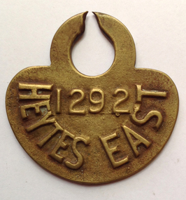
Functional object - Tag, cow Heytesbury East, late 20th century
... The Settlement was established in 1960 as a dairying area and was one of the largest post World War Two farming settlements. This cow tag has been broken at the top and detached from the animal....The Settlement was established in 1960 as a dairying area and was one of the largest post World War Two farming settlements. This cow tag has been broken at the top and detached from the animal. ...The Heytesbury Settlement Scheme in the area west of Colac and bordering the Otway Ranges. The Settlement was established in 1960 as a dairying area and was one of the largest post World War Two farming settlements. This cow tag has been broken at the top and detached from the animal.The item is of some interest as coming from the Heytesbuty Settlement. Dairying is of major importance in the Warrnambool area and this extends to the Heytesbury area. These cow tags have now been superseded by more improved technological equipment. This is a brass cow tag. It is semi-circular with a ring top, broken or worn through at the top. ‘1292’ ‘Heytes East’ heytesbury settlement scheme, cow tag -
Whitehorse Historical Society Inc.
Map, City of Nunawading Historical Geography Project
... Early colonists to coming of railway, 1880-1918 Land boom, bust to WW1, 1919-1944 Part WW1 to end of WW2, 1945-present Post war suburban explosion - farming, clay industries,settlement....Early colonists to coming of railway, 1880-1918 Land boom, bust to WW1, 1919-1944 Part WW1 to end of WW2, 1945-present Post war suburban explosion - farming, clay industries,settlement. City of Nunawading Historical Geography Project Map Map ...Periods covered 1834-1879. Early colonists to coming of railway, 1880-1918 Land boom, bust to WW1, 1919-1944 Part WW1 to end of WW2, 1945-present Post war suburban explosion - farming, clay industries,settlement.local history, heritage awareness study steering commitee, johnston chris, walker, vanessa, vosper, maria, kellaway, carlotta -
 Warrnambool and District Historical Society Inc.
Book - Yalla-Y-Poora On The Fiery Creek, James Affleck, Yalla-Y-Poora On The Fiery Creek when the cannon's roar was stilled, 2023
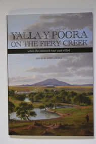
... Front cover has the Title: "Yalla-Y-Poora On The Fiery Creek when the cannon's roar was stilled" printed over a coloured print of Eugene von Guerard's painting of Yalla-y-Poora; Back cover: Three colour photographs soldier settlement farming family descendants, soldier settler house and tractor. ...Front cover has the Title: "Yalla-Y-Poora On The Fiery Creek when the cannon's roar was stilled" printed over a coloured print of Eugene von Guerard's painting of Yalla-y-Poora; Back cover: Three colour photographs soldier settlement farming family descendants, soldier settler house and tractor. ...Number Six in James Affleck's series of book on Soldier Settlements in Western Victoria. An edited compilation of settler families' own stories, combined with a reincorporation of a previously published history of the area, profiles of local people and organisations illustrated with maps, photographs and poetry136 page softcover book. Front cover has the Title: "Yalla-Y-Poora On The Fiery Creek when the cannon's roar was stilled" printed over a coloured print of Eugene von Guerard's painting of Yalla-y-Poora; Back cover: Three colour photographs soldier settlement farming family descendants, soldier settler house and tractor. Yalla-Y-Poora On The Fiery Creek printed on spine.non-fictionNumber Six in James Affleck's series of book on Soldier Settlements in Western Victoria. An edited compilation of settler families' own stories, combined with a reincorporation of a previously published history of the area, profiles of local people and organisations illustrated with maps, photographs and poetrysoldier settlement, yalla-y-poora -
 Kiewa Valley Historical Society
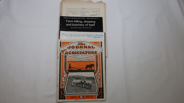
Journals - Department of Agriculture, 1. 1950s and 2. one 1932 & others 1970s
... The Kiewa Valley has been a farming district from early settlement of white people. This has continued until the present although the nature of farming has varied over the years. ...Kiewa Valley Historical Society Mount Beauty Information Centre 31 Bogong High Plains Rd Mt Beauty high-country The Kiewa Valley has been a farming district from early settlement of white people. This has continued until the present although the nature of farming has varied over the years. ...The Kiewa Valley has been a farming district from early settlement of white people. This has continued until the present although the nature of farming has varied over the years. Access to information has improved with transport and technology. The journals kept the farmers informed and up to date.These booklets and journals were one of the few sources of information during the 1950s for the isolated farmers of the Kiewa Valley. The Kiewa Hydro Electric Scheme improved both transport and technology during the scheme's construction from the 1940s. It provided the township of Mt Beauty at the upper end of the valley where shops and schools were constructed, roads were improved out of the valley and the supply of electricity for milking etc. became available. 1. 14 articles each bounded by 2 staples, and each reprinted from Dept. of Agriculture Journal on a particular topic relating to Agriculture. All black & white and c1950s. 2. 4 Journals with colored covers 3 from Victoria Dept. of Agriculture (1932, 1974 & 1975) and 1 from Sth. Australia.1. "J.H.Wallace" hand written top right corner of covers of pamphlets titled 'Diseases Affecting /Young Cattle' and 'Mastitis'. "AHW" hand written top right corner of cover of pamphlet titled ' Grading Land for Irrigation' 2. Nonefarming, agriculture, cattle, pasture, kiewa valley, department of agriculture in victoria, kiewa hydro electric scheme, -
 Arapiles Historical Society
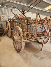
Vehicle - NORTHFIELD Wagon
... As a surviving example of rural transport equipment, it contributes to the understanding of farming, settlement and community life in western Victoria....As a surviving example of rural transport equipment, it contributes to the understanding of farming, settlement and community life in western Victoria. ...FROM - R A NORTHFIELD of Noradjuha This horse-drawn wagon was owned and used by R. A. Northfield of Noradjuha, a farming district located south of Horsham in Victoria's Wimmera region. Wagons of this type were essential items of farm equipment during the late nineteenth and early twentieth centuries, before motor trucks became widely available. Used behind teams of horses, wagons transported a wide variety of agricultural products and supplies, including bagged wheat, wool bales, hay, fencing materials, firewood, livestock feed and general farm produce. They also served as the principal means of moving goods between farms, railway sidings and rural townships. The heavy construction of the wagon reflects the demanding conditions of broadacre farming in the Wimmera, where large loads often had to be hauled across unsealed roads and paddocks. Such wagons were frequently used for decades and were often repaired and modified as required throughout their working lives. Significance: This wagon is significant as a representative example of the horse-powered transport technology that supported agricultural development throughout the Wimmera. Before the introduction of tractors and motor vehicles, wagons such as this formed the backbone of rural transport and were indispensable to farming operations. Its association with R. A. Northfield of Noradjuha provides an important local connection to one of the district's farming families and helps document the working methods employed on Wimmera farms during the horse-drawn era. The wagon demonstrates the craftsmanship of traditional wagon building and provides a tangible link to the period when horses supplied the primary motive power for transport and agriculture. As a surviving example of rural transport equipment, it contributes to the understanding of farming, settlement and community life in western Victoria.A substantial horse-drawn farm wagon constructed from timber and iron, mounted on four large wooden-spoked wheels fitted with iron tyres. The wagon features a rectangular timber tray with removable side rails and a robust undercarriage designed to carry heavy agricultural loads. Long timber shafts extend from the front axle assembly for attachment to a horse team. The wagon incorporates a turntable steering mechanism at the front, allowing the front wheels to pivot independently when negotiating corners. Iron braces, fittings and reinforcing straps strengthen the timber construction. The wagon displays considerable wear, weathering and evidence of long service in agricultural use.farm equipment, transport, northfield -
 Warrnambool and District Historical Society Inc.
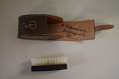
Clothes brush & holder, Mid 20th century
... Ballangeich is a small settlement on the Hopkins Highway about 27 kilometres from Warrambool. George Tomlinson’s grandfather, William Tomlinson , established a farming property at Ballangeich in 1865 and opened a hotel, ‘Half Way House’ on part of the land. ...Ballangeich is a small settlement on the Hopkins Highway about 27 kilometres from Warrambool. George Tomlinson’s grandfather, William Tomlinson , established a farming property at Ballangeich in 1865 and opened a hotel, ‘Half Way House’ on part of the land. ...The brush in this case could have been used as a hair brush or a clothes brush. It is enclosed in a leather case and was probably an item made for travellers. The brush and case belonged to George Tomlinson of Ballangeich. Ballangeich is a small settlement on the Hopkins Highway about 27 kilometres from Warrambool. George Tomlinson’s grandfather, William Tomlinson , established a farming property at Ballangeich in 1865 and opened a hotel, ‘Half Way House’ on part of the land. George Tomlinson’s father, also William, continued to farm in the area and was known as a fine judge of cattle and sheep. This case and brush are of interest as an example of the brushes men used in the mid 20th century. The items are also of interest as they belonged to a member of a well-known Ballangeich family (Tomlinsons).1 This is a piece of brown leather rolled over and stitched with yellow thread to form a container or case. The case has a closing mechanism – a leather strap and metal buckle. .2 Inside the leather case is a brush with a brown Bakelite back with horsehair inserted. ‘G.E. Tomlinson Ballangeich Victoria’men’s toiletries, ballangeich, history of warrnambool -
Warrnambool and District Historical Society Inc.
Document, Wollaston sale, 1919
... In 1919 the Closer Settlement Board of Victoria acquired Wollaston and 17 lots were sold to returned soldiers for farming purposes. ...In 1919 the Closer Settlement Board of Victoria acquired Wollaston and 17 lots were sold to returned soldiers for farming purposes. ...This is a poster advertising the sale of part of the Wollaston Estate in Warrnambool in 1919. The sections for sale were Allotments 1, 18 and 19 which included the Wollaston Homestead. The original Wollaston property of 679 acres was selected by Thomas Manifold in the late 1840s. This land, on the northern side of the Merri River, near the Woodford Road was three kilometres from the Warrnambool town. The first farmer we know who leased the property was William Simpson. Walter Manifold inherited the property and he took it over in 1884. The swing bridge he built in 1890 still stands today. In 1919 the Closer Settlement Board of Victoria acquired Wollaston and 17 lots were sold to returned soldiers for farming purposes. By 1930 there were only five soldier settlers remaining. In 2009 further subdivision took place with lots sold for residential purposes. The homestead allotments were sold separately in 1919 with various owners of the homestead itself recorded since that time. This poster is of interest as it shows the areas of the Wollaston Estate which were sold in 1919. The history of this estate is well-documented and of importance in the history of Warrnambool. This is a sheet of paper with red and black printing and a map of the Wollaston Estate which is photo-lithographed. The sheet has been folded three times. It has some small tears at the top of the page. wollaston, history of warrnambool, walter manifold -
 Warrnambool and District Historical Society Inc.
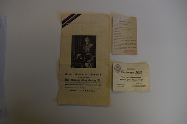
Memorabilia - Two articles of civic events in Warrnambool, Kaye & Son, Warrnambool Printers, mid 20th century
... Warrnambool was founded as a port settlement to service the farming interests in the area, with the first land sales held in Melbourne in July 1847. ...Warrnambool was founded as a port settlement to service the farming interests in the area, with the first land sales held in Melbourne in July 1847. ...The card relates to the Official Centenary Ball held in the Warrnambool Town Hall in March 1947 to celebrate the city's Centenary in 1947. Warrnambool was founded as a port settlement to service the farming interests in the area, with the first land sales held in Melbourne in July 1847. The leaflet is a programme of the Civic Memorial Service held in the Botanic Gardens in Warrnambool in February1952 on the occasion of the death of King George VI of England. Both items came from memorabilia held by the Bamford family of 8 Monash Avenue Warrnambool and it is presumed that one or more members of that family attended the events.These items are of social significance as mementos of events in Warrnambool in the mid 20th century..1 A white card with black printing and a logo .2 A sheet of white paper folded to make four pages with black printing and a photograph of King George VI of Englandwarrnambool memorabilia, warrnambool centenary, warrnambool centenary 1947, official centenary ball. -
 Warrnambool and District Historical Society Inc.
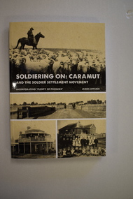
Book, StarPrinting Service Pty ltd, Soldiering On – Caramut and the Soldier Settler Movement, 2018
... Soldier Settlements in Victoria were established by the State Government to provide farming opportunities for returned soldiers. ...Warrnambool and District Historical Society Inc. 2 Gilles Street (south of Merri St) Warrnambool great-ocean-road Soldier Settlements in Victoria were established by the State Government to provide farming opportunities for returned soldiers. ...This book records the history of the post World War Two soldier settlement farms in the Caramut area. Number two in a series of books on Soldier Settlements in Western Victoria.This is a soft cover book of 315 pages. It has a buff-coloured cover with black and white photographs and white printing on the front cover and black printing on the spine. The book includes printed material, black and white photographs, maps and plans. non-fiction This book records the history of the post World War Two soldier settlement farms in the Caramut area. Number two in a series of books on Soldier Settlements in Western Victoria.james affleck, peterborough, soldier settlement, caramut, history of warrnambool, soldier settlement, caramut -
 Warrnambool and District Historical Society Inc.
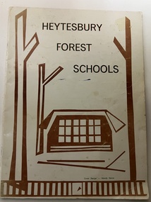
Booklet, Collett and Bain, Heytesbury Forest School, c.1971
... The Heytesbury Forest was largely deforested by the Bailey Closer Settlement Scheme of the 1930s and later the establishment of more farming properties in the 1950s. ...The Heytesbury Forest was largely deforested by the Bailey Closer Settlement Scheme of the 1930s and later the establishment of more farming properties in the 1950s. ...This booklet, by Rosamund Duruz, gives the history of the schools in the Heytesbury Forest area. The Heytesbury Shire Council was established in 1863 and the first schools in the area opened in the 1870s. Most of them were closed when Timboon Consolidated School (later Timboon High School) opened in 1948. The Heytesbury Forest was largely deforested by the Bailey Closer Settlement Scheme of the 1930s and later the establishment of more farming properties in the 1950s. This booklet is of interest as a comprehensive history of the schools in the Heytesbury Forest area pre 1970. It will be useful for researchers. This is a soft-cover booklet of 63 pages. The cover is a cream colour with brown images of trees and a school on the front cover. The booklet includes a map, a sketch and several black and white photographs. The booklet is bound with metal staples.schools in heytesbury forest, victoria, rosamund duruz, historian, history of warrnambool -
 Warrnambool and District Historical Society Inc.
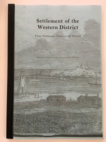
Booklet - Booklet: Settlement of the Western District, Collett, Bain and Gaspar, Printers, Settlement of the Western District From Prehistoric Times to the Present, 1985
... farming and sociology. This book is very useful as it contains articles on various aspects of the history of Western Victoria and is of considerable help to researchers and others interested in our local history. Several of the writers (eg. Critchett, Sherwood, Lewis, Ronald, Gill) have produced other writings on our local district. western victorian history edmund gill peter ronald john sherwood jan critchett tony dingle miles lewis kevin o’toole warrnambool history This booklet documents a public lecture series held in Warrnambool 3rd November 1984. Front Cover: ‘Settlement ...This booklet documents a public lecture series held in Warrnambool 3rd November 1984.This is a soft-cover book of 133 pages on the settlement of the Western District from prehistoric times to the present. It has a blue paper front cover and a grey paper back cover. The front cover is covered with a clear plastic sheet and the binding is plastic. The cover has an image of a sketch of the Warrnambool beach showing the lighthouse complex on Middle Island and the lighthouse on the beach (established 1860). There are a Contents page, a Foreword, a List of Plates and seven articles on different aspects of the Western District history by different authors. There are black and white photographs and illustrations. One page (p.17) has been annotated by Les O’Callaghan.This booklet documents a public lecture series held in Warrnambool 3rd November 1984.western victorian history, edmund gill, peter ronald, john sherwood, jan critchett, tony dingle, miles lewis, kevin o’toole, warrnambool, history -
 Warrnambool and District Historical Society Inc.
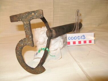
Functional object - Farming Equipment Branding Iron, Circa 1840
... If this item is an authentic Bolden piece of property then it is the oldest artefact from the time of white settlement that is held by the Warrnambool and district Historical society. The item itself while a common farming implement and which was found on a farm originally owned by the Bolden Brothers is a link with the earliest part of Warrnambool’s history. ...Armyne, George and Lemuel Bolden were original landholders of large parts of land in the Western district. Portions of it extended from Pirron Yallock in the East to almost as far as Portland. The head station was at Grasmere. They were noted breeders of shorthorn cattle in fact they were some of the first men to bring the breed to Victoria and thus helped to pioneer the Australian Shorthorn breeding Industry. This branding iron was found at Lyall Park, originally 640 acres selected by William Lyall at Cooramook. It is believed to be a branding iron dating from when the land was occupied by the Bolden Brothers. The Bolden Brothers were the first to erect considerable lengths of fencing in the Warrnambool area. If this item is an authentic Bolden piece of property then it is the oldest artefact from the time of white settlement that is held by the Warrnambool and district Historical society. The item itself while a common farming implement and which was found on a farm originally owned by the Bolden Brothers is a link with the earliest part of Warrnambool’s history.Short, round wooden handle with metal brand in the shape of the letter T with two thirds circle attached to vertical part of T. Daub of paint at end of handle . T 5Paper label attached with green tape with 931 in texta and hand written on back,” branding iron reputed to have been used by Bolden Bros Grasmere c 1840. warrnambool, bolden brothers, armyne bolden, george bolden, lemuel bolden, branding iron, shorthorn cattle -
 Warrnambool and District Historical Society Inc.
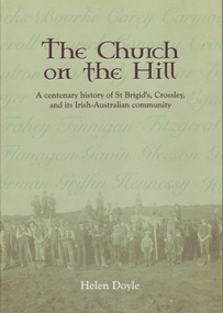
Book, Helen Doyle, The Church on the Hill :A centenary history of St. Brigid’s Crossley and its Irish Catholic community, 2014
... farming and religious and school life of the region. It looks at church traditions and issues of the day such as conscription during World War 1.There is also a large section relating to a large number of families who settled in the district. This book relates the story of the settlement ...History of St Brigid's Catholic Church and the Irish-Australian communityGreen tinted paperback with photograph of farming men with children and horses on front cover. Title and other text is dark brown edged in white. A number of Irish surnames are written in darker green on the paler part of front cover. This effect is also on back cover in tan lettering. The back cover description is written in brown text with image in oval above text.non-fictionHistory of St Brigid's Catholic Church and the Irish-Australian community warrnambool, crossley, st brigid's church, crossley catholic church, helen doyle -
 Warrnambool and District Historical Society Inc.
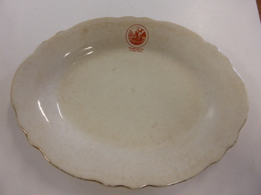
Plate Pottery, Serving Plate Parramatta, Late 19th century
... Being within a reasonable distance to the settlement of Sydney and in an area of fertile soil, it soon became a successful farming region. ...Being within a reasonable distance to the settlement of Sydney and in an area of fertile soil, it soon became a successful farming region. ...The settlement of Parramatta is one of the earliest inland settlements in Australia being settled in November 1788 just months after the arrival of the First Fleet to Sydney. Originally named Rose Hill it was given the name Parramatta which closely approximated the original Aboriginal name for the area. Being within a reasonable distance to the settlement of Sydney and in an area of fertile soil, it soon became a successful farming region. It was proclaimed a city in 1938. This plate possibly belongs to either the commemoration of 100 or 150 years of settlement of the area, although the stamp on the plate is the same drawing as that on the official invitation for 1938While this plate has no local historical links , it does have significance belonging to one of the earliest settlements in Australia.White oval plate with fluted edge with gold on rim. Small orange stamp on one edge.Parramatta 2 Nov 1788 on one edge of plate. Stamp on back: Grimwades Staffordshire England Upper Hanley Pottery. Semi porcelainwarrnambool, parramatta, serving plate -
 Warrnambool and District Historical Society Inc.
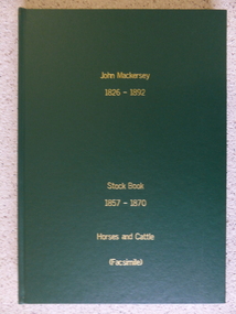
Book - Facsimile: John Mackersey 1826-1892, Stock Book 1857-1870, 2014
... farming. It records purchases and stock sold, wool clips, lambs, sheep losses and different breeds. Kenilworth was a significant property in the Western District of Victoria and it dates from a period of early settlement in Victoria. ...This ledger relates to the property Kenilworth which is situated near Cavendish, 16 miles from Hamilton on the Wannon River. It was taken up by Thomas Norris in 1839 and originally carried 800 cattle and 20000 sheep on 63000 acres. By 1858 it was in the hands of John Mackersey and Thomas Bostock. In 1859 it belonged outright to John Mackersey who was there until 1870. He was considered a worthy son of a Presbyterian minister and was well regarded in the district for his contributions in church, sport and sheep breeding... However he did not do well and lost the property before going to New Zealand in 1870. These journals provide a yearly record of flock, harvest and yields along with income details. It also provides details relating to rentals, selections and purchases during the era from squatting to freehold land. This journal provides a detailed view of matters relating to the business of sheep farming. It records purchases and stock sold, wool clips, lambs, sheep losses and different breeds. Kenilworth was a significant property in the Western District of Victoria and it dates from a period of early settlement in Victoria.Dark green hard cover with gold lettering. Both covers have in gold lettering: John Mackersey1826-1892 Stock Book 1857-1870. One cover has Horses and cattle and the other, sheep. It is a facsimile copy. The two sections are divided by a green sheet of paper. Acknowledgements to The State Government of Victoria, State Library of Victoria, Hamilton History Centre, Dr G Handbury AO, Margaret Gardiner, Godfrey and Margaret Mackersey, L Alan Brumley, M P Heuval. john mackersey, thomas bostock, thomas norris, kenilworth, history of warrnambool -
 Warrnambool and District Historical Society Inc.
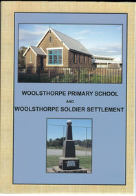
Book, Woolsthorpe Primary School and Woolsthorpe Soldier Settlement
... The Woolsthorpe Soldier Settlement farms usually had between 290 and 600 acres and were mostly used for mixed farming and sheep grazing....The Woolsthorpe Soldier Settlement farms usually had between 290 and 600 acres and were mostly used for mixed farming and sheep grazing. ...History of the Woolsthorpe Primary School and Woolsthorpe Soldier SettlementThis is a soft-cover book with a blue and buff- coloured front cover featuring photographs of the Woolsthorpe Primary School and the Woolsthorpe War Memorial. The back cover has photographs of the R.S.L. Badge and the Woolsthorpe Primary School. It has 160 pages. non-fictionHistory of the Woolsthorpe Primary School and Woolsthorpe Soldier Settlementwarrnambool, woolsthorpe, soldier settlement -
 Warrnambool and District Historical Society Inc.
Document, Indenture A Bostock Esquire to Messrs Aitkin & Bostock( Ernest), 1865
... settlement. They leased and owned vast tracts of land and operated businesses around the district, often associated with the farming industry. ...settlement. They leased and owned vast tracts of land and operated businesses around the district, often associated with the farming industry. ...The Bostock, Manifold and Aitkin families were all pioneering families in the Western District of Victoria almost from the time of settlement. They leased and owned vast tracts of land and operated businesses around the district, often associated with the farming industry. This document is dated 5th July 1865 and is an assignment of stock by way of mortgage. Augustus Bostock is the mortgagor with James William Manifold Aitkin and Ernest Bostock as mortgagees. At various times they were involved in running businesses together, in particular the Aitkin and Bostock store and flour mill. Three of the Bostock men were married to three of the Aitkin sisters. The amount in question is £2157/3/2 and surety is 8000 sheep and their increase, presently running at Coomete. The penciled in details on the document refer to Robert Brand Paterson who was later in business with Aitkin This is one of a number of documents which relate to the Bostock family who were one of the most important pioneering families of the Western District. They owned and leased various properties around Warrnambool and were involved in many aspects of social and business life. The document itself is indicative of its time and provides an insight into the details and terms of such documents at the time.Large grey coloured, lined hand written document over four pages. Folded in four with date and details on one section. Red wax seal on page 3. There are extra entries written in black lead pencil in areas relating to the money and surety of the agreement.Signed by the following George Barber Warrnambool, Thomas Sunderland Deputy Registrar General, and Augustus Bostock. Hingston & Co, Chancery Lane Melbourne hand written in top left hand corner. warrnambool, bostock,augustus bostock james william manifold aitkin,robert brand paterson, coomete, -
 Kiewa Valley Historical Society
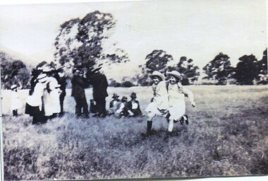
Photograph - Tawonga Sports Day
... The Ryder and Briggs families have been prominent farming families in the local area since early settlement. ...The Ryder and Briggs families have been prominent farming families in the local area since early settlement. Vera Ryder and Alli Briggs were pupils at Tawonga Primary School in the early 1920's. ...Tawonga is in the Kiewa Valley, where local farmers lived with their families. The Ryder and Briggs families have been prominent farming families in the local area since early settlement. Vera Ryder and Alli Briggs were pupils at Tawonga Primary School in the early 1920's. Their families were prominent in the settlement of the Kiewa ValleyCopy of black and white photograph of 3 legged race at Tawonga Sports Day circa 1920's (estimate only) Vera Ryder & Allie Briggs racing in the foreground. Various adults and children standing in the background.Printed label attached to rear. Tawonga Sports Day. Vera Ryder and Allie Briggs - 3 legged race. Girls have white aprons over their dresses.tawonga, sports day, kiewa valley farmers -
 Kiewa Valley Historical Society
Photograph Shovel Truck, Shovel Loading Rail Truck, circa 1950s
... The fast expansion of smaller settlements brought about increased pressures on the welfare viability of certain subgroups within the region e.g. farming, droving and commerce (caravan hawkers versus static shops). ...This item shows the excavation of the side of a railway track using a pneumatic shovel and a rail mounted truck by two workmen. The period covered was well before State Health and Safety requirements, such as helmets, became law. It also details that the workmen were from European heritage as their head coverings were a handkerchief knotted at each corner. This was typical for workmen of this heritage, others used caps or hats or no head covering at all (the macho male look)The photograph of this item was one of many depicting great achievements and opening up the region. A visual link or time capsule of the 1950s rural/mining sectors clashing with the established rural industriesThis photo depicts the time (1950's) and place (Bogong and Mount Beauty) where construction workers had an immense impact, not only on the physical environment but also on the social and economic development of the Victorian Alps region. The fast expansion of smaller settlements brought about increased pressures on the welfare viability of certain subgroups within the region e.g. farming, droving and commerce (caravan hawkers versus static shops). These changes brought about a heightened awareness by both local and State Governments to upgrade not only facilities within the region but also access to the region. Black and white photo of two workmen on a rail mounted shovel truck. The photo is of good definition allowing a clear view of the subject matter. The paper is semi gloss.On the back of the photo, paper suppliers etchings are "Kodak XtraLife II paper"mining, hydro electricity, victorian alps, construction camps, earth moving machines -
Streatham and District Historical Society
Picture, George Davis & Bell
... Settlement scheme which broke it up for return soldiers. Many people were employed at the station during this time. George Davis lived in Streatham during this period. Shows local areas in the Western District and one of the residents. horse agriculture george rural farming streatham transport yalla poora stations davis In red ink stamped across back Kodak 85m. ...Yalla-Y-Poora was a large station until the a soldier Settlement scheme which broke it up for return soldiers. Many people were employed at the station during this time. George Davis lived in Streatham during this period.Shows local areas in the Western District and one of the residents.Rectangular shape. Black & white. Man (George Davis) standing with a horse behind a barbed wire fence with several items hanging across it. There is gum trees in a line behind.In red ink stamped across back Kodak 85m. In blue ink pen, George Davis with Bell at Yalla-Y-Poora 1929.horse, agriculture, george, rural, farming, streatham, transport, yalla poora, stations, davis -
 Orbost & District Historical Society
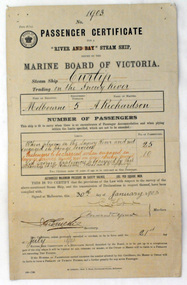
certificate, 30th January 1903
... settlement on the Brodribb River, a tributary of the Snowy River. Curlip's keel was laid on 14th October 1889 and PS Curlip was launched in 1890. The Paddle Steamer Curlip was designed to travel up and down the Snowy and Brodribb Rivers with essential supplies from coastal ketches and schooners, that plied their trade up and down the coast between Melbourne, Sydney and Tasmania. The Curlip regularly towed one or two barges and up to five barges loaded with local farming...settlement on the Brodribb River, a tributary of the Snowy River. Curlip's keel was laid on 14th October 1889 and PS Curlip was launched in 1890. The Paddle Steamer Curlip was designed to travel up and down the Snowy and Brodribb Rivers with essential supplies from coastal ketches and schooners, that plied their trade up and down the coast between Melbourne, Sydney and Tasmania. The Curlip regularly towed one or two barges and up to five barges loaded with local farming ...This certificate was issued on January 30, 1903 to Captain Alan Richardson by the Marine Board of Victoria entitling her to carry 25 passengers and only 10 passengers when engaged in towage service. Two children under 12 years of age to be reckoned as one passenger. The penalty of 20 pounds would be levied if these limits were exceeded. the certificate was valid until 21st July 1903. The original Paddle Steamer Curlip was built by Sam Richardson and his sons Mark, Albert and Frank, at their sawmill at Tabbara, a pioneering settlement on the Brodribb River, a tributary of the Snowy River. Curlip's keel was laid on 14th October 1889 and PS Curlip was launched in 1890. The Paddle Steamer Curlip was designed to travel up and down the Snowy and Brodribb Rivers with essential supplies from coastal ketches and schooners, that plied their trade up and down the coast between Melbourne, Sydney and Tasmania. The Curlip regularly towed one or two barges and up to five barges loaded with local farming produce and timber for the thriving cities, that was loaded offshore or in the Snowy River estuary, tide and depth permitting, on to the trading vessels.This item is associated with the P.S. Curlip and the Richardson family, early Orbost pioneers.A paper passenger certificate for a river steam ship.Details are handwritten in black and red ink.curlip-p.s. certificate-passenger richardson -
 Wycheproof & District Historical Society Inc.
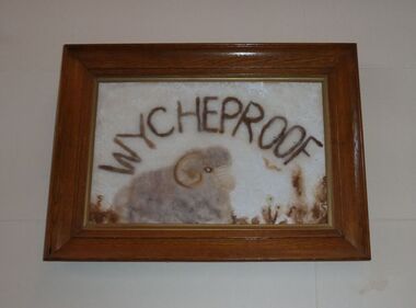
Wool Picture, Wycheproof Craft Group Emblem, 1984 (exact)
... The wool industry, since Wycheproof's settlement days, has greatly supported the town, families and farming in general.The wool picture is the emblem of a local group that met between 1977 and 2010....The wool industry, since Wycheproof's settlement days, has greatly supported the town, families and farming in general.The wool picture is the emblem of a local group that met between 1977 and 2010. ...The Wycheproof Craft Group emblem made by Mrs Elaine Storey depicts a large ram and showcases beautifully, wool colours and versatility of creator and medium used. The wool industry, since Wycheproof's settlement days, has greatly supported the town, families and farming in general.The wool picture is the emblem of a local group that met between 1977 and 2010.This item is aesthetically significant as a visually pleasing craft piece that demonstrates the adaptability of skills to raw materials.It is representative of the lifeblood of the town of Wycheproof for 145 years.A framed wool picture constructed entirely from natural fleece, showing a merino ram in a paddock with natural looking vegetation growth. The subject aptly lends itself to a subtle display of various shades of wool colours. It is framed in oak wood.The word WYCHEPROOF is worked in fleece in an arc formation.Wycheproof Craft Group 1977-2010storey, wycheproof craft, wycheproof wool, spinners weavers, elaine -
 Wycheproof & District Historical Society Inc.
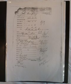
Dempsey Book, Dempsey Land Selection, 2003l
... Several official Lands Department correspondence provides evidence of Dempsey's early land acquisition at the beginning of the town's farming history and settlement from 1872 - 1882. dempsey land -act bunguluke This is an A3 sized Display book with grey spine. ...Mr Dempsey and family were the first selectors to arrive at Mt Wycheproof 1872 or early 1873. One Dempsey Land Application is dated 15-3-1873.Factual documents obtained from a Melbourne archive show settler,John Dempsey,securing land at Wycheproof. Several official Lands Department correspondence provides evidence of Dempsey's early land acquisition at the beginning of the town's farming history and settlement from 1872 - 1882. This is an A3 sized Display book with grey spine. Comprises official Lands Department Papers detailing Mr John Dempsey's Land Applications and acquisition at Wycheproof. Dated documentation is from 1872 through to 1882.Locally researched references give an overview about the Dempsey family.dempsey, land -act, bunguluke -
 St Arnaud and District Historical Society
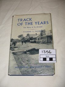
Book. Track of the Years, Track Of The Years. The Story of St.Arnaud.By Yvonne S Palmer
... Sons of the Antipodes, Diggers in Townsmen, Daughters and Wives, Companies and Miners, Mining Settlements, Increasing Needs, Not by Bread Alone, The beginning of Farming, The Changing Countryside, A New St.Arnaud has Come, Deep Sinking and Dividends, Fewer farmers- Larger farms, Pride but not Complacency....Sons of the Antipodes, Diggers in Townsmen, Daughters and Wives, Companies and Miners, Mining Settlements, Increasing Needs, Not by Bread Alone, The beginning of Farming, The Changing Countryside, A New St.Arnaud has Come, Deep Sinking and Dividends, Fewer farmers- Larger farms, Pride but not Complacency. 1st Edition Published by Melbourne University Press in 1955. 308 pages. ...TRACK OF THE YEARS. The Story of St.Arnaud by Yvonne S Palmer had aroused local interest when this book was presented in 1955.The fortunes of this prosperous community, whose origins go back to the excitement of of the New Bendigo gold-rush, gleaned from an unusual wealth of reminiscences,diaries, letters, newspapers and photograph albums, are now placed permanently on record in this fascinating narrative. Contents: The New Bendigo Goldrush, Pastoral Settlement, The Aborigines of the Eastern Wimmera, A Permanent Goldrush, The Township Surveyed, Councils at Work 1861- 1870, Local Government in the District. 1861-1870. Sons of the Antipodes, Diggers in Townsmen, Daughters and Wives, Companies and Miners, Mining Settlements, Increasing Needs, Not by Bread Alone, The beginning of Farming, The Changing Countryside, A New St.Arnaud has Come, Deep Sinking and Dividends, Fewer farmers- Larger farms, Pride but not Complacency.Track of The Years by Yvonne S. Palmer. The Story of St.Arnaud. Hardcover book, blue cover with black and white photograph on the dustcover.Includes photographs and maps.308 pages, 1st Edition.1st Edition Published by Melbourne University Press in 1955. 308 pages. -
 Eltham District Historical Society Inc
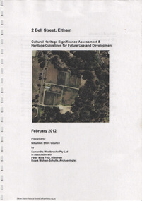
Document, Samantha Westbrooke Pty Ltd et al, 2 Bell Street, Eltham: Cultural Heritage Significance Assessment & Heritage Guidelines for Future Use & Development, 2012
... settlement in the late 1830s. The site for the village of Eltham was surveyed in 1851 and the Township Plan shows that the property is made up of Lots 7 and 8 which were sold at auction in June 1852 to M. O'Shea. The history of the Bell Street property is closely tied to the West family from the 1860s to 1930s; the earliest rate books for Eltham show William West farming in El;tham in 1864. ...settlement in the late 1830s. The site for the village of Eltham was surveyed in 1851 and the Township Plan shows that the property is made up of Lots 7 and 8 which were sold at auction in June 1852 to M. O'Shea. The history of the Bell Street property is closely tied to the West family from the 1860s to 1930s; the earliest rate books for Eltham show William West farming in El;tham in 1864. ...Prepared for Nillumbik Shire Council by Samantha Westbrooke Pty Ltd in association with Peter Mills PhD, Architectural Historian and Roark Muhlen-Schilte, Archaeologist. Covers history of early market gardening in Eltham with the commencement of European settlement in the late 1830s. The site for the village of Eltham was surveyed in 1851 and the Township Plan shows that the property is made up of Lots 7 and 8 which were sold at auction in June 1852 to M. O'Shea. The history of the Bell Street property is closely tied to the West family from the 1860s to 1930s; the earliest rate books for Eltham show William West farming in El;tham in 1864. In the aerly 1930s ownership of the creek side was transferred from the west family to the Fabbro family who shortly afterwards were impaced by the 1934 Diamond Creek flooding. Guido Fabbro relocated the original West home further up the hill and built a new Italianate style modern home in situ. The Fabbro family farmed the property. In 1993/4 Eltham Council acquired the creek-side market garden blocks to the south of 2 Bell Street which was recconceived in 1998 as the Barak Bushland Reserve. The Fabbro house was demolished shortly after and the lots were sold to a developer in 1994. The large steel shed now present on the 2 Bell Street property dates from soon after this sale.26 A4 pages color printcultural heritage significance assessment, peter mills, samantha westbrooke pty ltd, shire of nillumbik, 2 bell street, eltham, market gardening, west family, fabbro family, land use, barak bushland reserve, heritage assessment -
 Eltham District Historical Society Inc
Film - Video (DVD), Neisha Forbes et al, Tales of Old Nillumbik; stories of life in years gone by - Plenty Historical Society, 15 November 2005
... settlement of Plenty. Learn about the mills situated on the Plenty River from the 1840s. Early industry such as fruit growing, poultry farming, goldmining, rabbit skinning and how they contributed to the development and employment of the area and in the case of rabbit skinning the development of other industries in Victoria during the Depression...settlement of Plenty. Learn about the mills situated on the Plenty River from the 1840s. Early industry such as fruit growing, poultry farming, goldmining, rabbit skinning and how they contributed to the development and employment of the area and in the case of rabbit skinning the development of other industries in Victoria during the Depression Video Recording DVD converted to MP4 01:01:12 duration 264MB Tales of Old Nillumbik; stories of life in years gone by - Plenty Historical Society Film Video (DVD) Neisha Forbes Plenty Historical Society Marie Ryan ...A series of talks held October - December 2005 at the Eltham Living and Learning Centre which allowed Nillumbik Historical Societies to record the verbal history of the area with some of the well known residents of Nillumbik and surrounds Recorded and edited by Marie Ryan of Plenty Valley FM Speaker: Neisha Forbes 15th November 2005 This session covers the early settlement of Plenty. Learn about the mills situated on the Plenty River from the 1840s. Early industry such as fruit growing, poultry farming, goldmining, rabbit skinning and how they contributed to the development and employment of the area and in the case of rabbit skinning the development of other industries in Victoria during the Depressionvideo recording -
 Eltham District Historical Society Inc
Photograph - Digital Photograph, Alan King, Yarrambat Heritage Museum, 23 January 2008
... settlement. The museum includes the original Yarrambat Primary School, which was moved to the site in 2000 and now serves as the Yarrambat Historical Society headquarters.The museum also includes a fully operational battery (gold-bearing ore crusher) driven by a McDonald 30HP diesel engine built in Richmond in 1938. The battery was relocated from the Golden King Mine in North Oatlands Road, Yarrambat, where it operated until 1984.1 Other exhibits include farming...settlement. The museum includes the original Yarrambat Primary School, which was moved to the site in 2000 and now serves as the Yarrambat Historical Society headquarters.The museum also includes a fully operational battery (gold-bearing ore crusher) driven by a McDonald 30HP diesel engine built in Richmond in 1938. The battery was relocated from the Golden King Mine in North Oatlands Road, Yarrambat, where it operated until 1984.1 Other exhibits include farming ...Original Yarrambat Primary School building at the Yarrambat Heritage Museum, Yarrambat Park. At the museum, visitors can gain an insight into Yarrambat’s past since non-Aboriginal settlement. The museum includes the original Yarrambat Primary School, which was moved to the site in 2000 and now serves as the Yarrambat Historical Society headquarters.The museum also includes a fully operational battery (gold-bearing ore crusher) driven by a McDonald 30HP diesel engine built in Richmond in 1938. The battery was relocated from the Golden King Mine in North Oatlands Road, Yarrambat, where it operated until 1984.1 Other exhibits include farming implements and machinery from the Yarrambat district. Published: Nillumbik Now and Then / Marguerite Marshall 2008; photographs Alan King with Marguerite Marshall.; p25This collection of almost 130 photos about places and people within the Shire of Nillumbik, an urban and rural municipality in Melbourne's north, contributes to an understanding of the history of the Shire. Published in 2008 immediately prior to the Black Saturday bushfires of February 7, 2009, it documents sites that were impacted, and in some cases destroyed by the fires. It includes photographs taken especially for the publication, creating a unique time capsule representing the Shire in the early 21st century. It remains the most recent comprehenesive publication devoted to the Shire's history connecting local residents to the past. nillumbik now and then (marshall-king) collection, yarrambat heritage museum, yarrambat historical society, yarrambat primary school -
 Eltham District Historical Society Inc
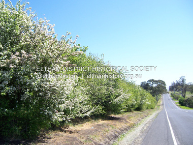
Photograph - Digital Photograph, Marguerite Marshall, Hawthorn hedges, Eltham-Yarra Glen Road, Kangaroo Ground, 3 October 2006
... They are "historically significant because the planting of hawthorn hedges reflects the adoption of Eurorpean farming techniques by the Kangaroo Ground population in the period following settlement and because the grid pattern of paddocks that the Hawthorn hedges define is very different to today's farm landscapes." ...They are "historically significant because the planting of hawthorn hedges reflects the adoption of Eurorpean farming techniques by the Kangaroo Ground population in the period following settlement and because the grid pattern of paddocks that the Hawthorn hedges define is very different to today's farm landscapes." ...Hawthorn hedges are important reminders of Kangaroo Ground's Scottish heritage. They are Registered on the Victorian Heritage Register. They are "historically significant because the planting of hawthorn hedges reflects the adoption of Eurorpean farming techniques by the Kangaroo Ground population in the period following settlement and because the grid pattern of paddocks that the Hawthorn hedges define is very different to today's farm landscapes." Covered under Heritage Overlay, Nillumbik Planning Scheme. Published: Nillumbik Now and Then / Marguerite Marshall 2008; photographs Alan King with Marguerite Marshall.; p21 Hawthorn hedges bordering Kangaroo Ground’s gently rolling farmlands are important reminders of its Scottish heritage and are rare so close to Melbourne.1 As early as the 1840s newly arrived farmers from Scotland planted hawthorn hedges around their properties, to protect crops from the numerous kangaroos and wallabies. Many of these hedges survive today. These farmers had the good fortune to settle some of the most fertile land available for cropping in the Colony of Victoria. At that time the black volcanic soil could sustain an amazing two crops a year. By the mid 1850s, 500 acres (202ha) of wheat were growing in Kangaroo Ground. But the crops were threatened by kangaroos, which were so plentiful, that Surveyor-General, Robert Hoddle, named the district Kangaroo Ground in 1838. As post-and-rail fences proved inadequate barriers for the bounding kangaroos, the Scots planted hawthorn hedgerows as they had done in Scotland. Some also used the hedges to net birds, presumably for the table. Interestingly the farmers in the bordering townships of Panton Hill and Christmas Hills, did not plant hawthorn hedges around their properties. Perhaps it was because by the time they settled in the 1860s and 1870s most of the wildlife had been gunned down by residents.2 The canny Scots planted the hedges on public land outside their own farms, as the hedgerows could spread to about five yards (five m) in width. With this impenetrable barrier Kangaroo Ground’s industrious farmers flourished to gain the economic power that saw the Shire of Eltham governed from Kangaroo Ground for 79 years (1858-1937). The Scots jealously guarded their land, so hard to get in Scotland. That is why they refused to release any of it ‘for local roads to follow easier grades as was the case in surrounding districts where roads generally followed ridgelines or streams’.3 Instead the roads were built in accordance with the magnetic bearings of their first survey in 1847 whether that suited the steep topography or not. This could force traffic to diverge when wet through Greensborough and Diamond Creek. Until 1921, the Eltham-Yarra Glen Road beside Wellers Restaurant, ‘dipped down into the upper reaches of Stony Creek’.4 Later some corners were compulsorily cut for the increasing motor traffic. As late as the 1960s, corners were cut to form sweeping curves above and alongside the Kangaroo Ground Cemetery and opposite the Emergency Operations Centre. In the latter case, the farmers – understanding their hedgerows as important heritage – insisted upon their reinstatement to conform to the altered road alignment. Kangaroo Ground’s ancient manna gums also point to the district’s history and to that of the hedgerows. The Aboriginal people had transformed the original forests into grasslands with the fires they lit to attract kangaroos, (which the Scots were to exclude by planting hedgerows). But the Wurundjeri hunters left the gums (Eucalyptus vimminalis cygnetensis), on the grasslands as ‘stalking trees’ to hunt kangaroos. The hawthorn hedges in Kangaroo Ground were neglected for around 60 years from about the middle of the 20th century. Bushfires had created gaps and the hedgerows were not trimmed. Then in late 2005, local historian Mick Woiwod, formed a group to lobby the Nillumbik Shire to restore the hedges, which could last for many centuries. Some hedges in parts of Britain date back to AD 800.5 Although the original Scottish farmers have gone, the hedges are a reminder of when they flourished in the district, which has changed little in 150 years.This collection of almost 130 photos about places and people within the Shire of Nillumbik, an urban and rural municipality in Melbourne's north, contributes to an understanding of the history of the Shire. Published in 2008 immediately prior to the Black Saturday bushfires of February 7, 2009, it documents sites that were impacted, and in some cases destroyed by the fires. It includes photographs taken especially for the publication, creating a unique time capsule representing the Shire in the early 21st century. It remains the most recent comprehenesive publication devoted to the Shire's history connecting local residents to the past. nillumbik now and then (marshall-king) collection, eltham-yarra glen road, hawthorn hedgerow, kangaroo ground -
 Bendigo Historical Society Inc.
Book - COUSIN JACK MAN FOR THE TIMES, 1994
... Settlement in Victoria... industry and manufacture... farming...History House 11 Mackenzie Street Bendigo goldfields VICTORIA History cornish people Settlement in Victoria industry and manufacture farming etc. Ruth Hopkins Cousin Jack, Man for the Times. ...Cousin Jack, Man for the Times. A history of the Cornish People in Victoria. Between the pages is a short page of notes written by Alex Stone, listing topics and page numbers at which these topics maybe found.Ruth Hopkinsvictoria, history, cornish people, settlement in victoria, industry and manufacture, farming, etc.