
Showing 29 items matching "kilvington drive"
-
 Emerald Museum & Nobelius Heritage Park
Photograph - Kilvington Drive, 2010
... Kilvington Drive......Kilvington Drive...Photograph of Kilvington Drive (April 2010) before the block of shops adjoining the old police residence (currently an opportunity shop) was built....Photograph Kilvington Drive ...The Teasdale family were shop proprietors in the 1940s and 1950s in Emerald. Kevin Teasdale has written extensively about Emerald in that period. His writings are stored with photographs in his family folder in Filing Cabinet 6C. They are a valuable addition to understanding Emerald's history in the mid-20th century. This photograph was taken by Kevin as a record of the changes in the Kilvington Drive streetscape.Black and white rectangular photograph printed on matte photographic paper. Photograph of Kilvington Drive (April 2010) before the block of shops adjoining the old police residence (currently an opportunity shop) was built.Written on back of photograph in biro presumably by Bill Teasdale: 'Taken in April, 2010. This photo shows the Kilvington Dve streetscape before the block of shops adjoining the police residence were built.'kevin teasdale, 2010, police residence, kilvington drive -
 Emerald Museum & Nobelius Heritage Park
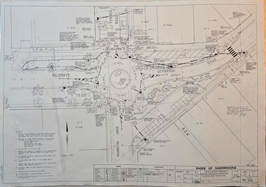
Map - Surveyors Map of new roundabout to be installed at the intersection of Belgrave-Gembrook Rd. and Kilvington Drive, Emerald 1988, Shire of Sherbrook, Roundabout at intersection of Belgrave-Gembrook Rd., and Kilvington Dve., Emerald, drawn 1988 - surveyors map, c1988
... Surveyors Map of new roundabout to be installed at the intersection of Belgrave-Gembrook Rd. and Kilvington Drive, Emerald 1988...Image of surveyors map outlining dimensions for new roundabout at the intersection of Belgrave-Gembrook Rd., and Kilvington Drive 1988.../Ferres Road/Kilvington Drive Intersection/Signed 13/8/88/Legend/Amendments/map.../Ferres Road/Kilvington Drive Intersection/Signed 13/8/88/Legend/Amendments/map Image of surveyors map outlining dimensions for new roundabout at the intersection of Belgrave-Gembrook Rd., and Kilvington Drive 1988 Roundabout at intersection of Belgrave-Gembrook Rd., and Kilvington Dve., Emerald, drawn 1988 - surveyors map Map Surveyors Map of new roundabout to be installed at the intersection of Belgrave-Gembrook Rd. and Kilvington Drive, Emerald 1988 Shire of Sherbrook ...Image of surveyors map outlining dimensions for new roundabout at the intersection of Belgrave-Gembrook Rd., and Kilvington Drive 1988non-fiction -
Emerald Museum & Nobelius Heritage Park
Photograph - Beaconsfield Road streetscape, c1948, 1948
... ...Kilvington Drive...Photograph of three children standing on Beaconsfield Road (present-day Kilvington Drive). The view looks toward Belgrave-Gembrook Road . ...On back of photo written in biro (presumably by Kevin Teasdale): 'Emerald Streetscape looking along Beaconsfield Road (now Kilvington Drive) towards Belgrave-Gembrook Road, from in front of the Police Residence c1948. ...Kevin Teasdale 1940s Kilvington Drive shops On back of photo written in biro (presumably by Kevin Teasdale): 'Emerald Streetscape looking along Beaconsfield Road (now Kilvington Drive) towards Belgrave-Gembrook Road, from in front of the Police Residence c1948. ...The Teasdale family were shop proprietors in the 1940s in Emerald. Kevin Teasdale has written extensively about Emerald in that period. His writings are contained with photographs in his family folder in Filing Cabinet 6C.Black and white rectangular photograph printed on matte photographic paper. Photograph of three children standing on Beaconsfield Road (present-day Kilvington Drive). The view looks toward Belgrave-Gembrook Road . Local shops (the Teasdale boot shop and fruit shop, Hogan's Coffee Palace and Legge's store are just visible. The three children are presumably Kevin and his younger siblings.On back of photo written in biro (presumably by Kevin Teasdale): 'Emerald Streetscape looking along Beaconsfield Road (now Kilvington Drive) towards Belgrave-Gembrook Road, from in front of the Police Residence c1948. On the left side, Edward Teasdale's bootshop, Hogan's Coffee Palace & my parents' fruit shop are visible. On the right side, Legges' "The Big Store" is visible.'kevin teasdale, 1940s, kilvington drive, shops -
 Emerald Museum & Nobelius Heritage Park
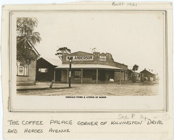
Photograph, Emerald Store & Avenue of Honor, 1920s-1940s
... Anderson's store on the corner of what is now Kilvington Drive and Heroes Avenue. At the time, these may have respectively been Beaconsfield Road and, according to the label, Avenue of Honor. ...Obverse: Backing, Top: "Built 1921" Backing, Bottom: "THE COFFEE PALACE CORNER OF KILVINGTON DRIVE / AND HEROES AVENUE" Photograph, Printed Text Below Image: "EMERALD STORE & AVENUE OF HONOR" Photograph, Sign in Left of Image: "IRVINE'S / CHOICE WINES" Photograph, Sign in Centre-Left of Image: "W. ...Kilvington Drive, Emerald, Victoria, Australia...Anderson's store on the corner of what is now Kilvington Drive and Heroes Avenue. At the time, these may have respectively been Beaconsfield Road and, according to the label, Avenue of Honor. ...This photograph depicts W. M. Anderson's store on the corner of what is now Kilvington Drive and Heroes Avenue. At the time, these may have respectively been Beaconsfield Road and, according to the label, Avenue of Honor. Anderson's store is believed to have been built by the Stillwell family in 1921, but Anderson had his store at least from 1923 and therefore likely owned it from the point of its first construction. By the late 1940s, Anderson's had become Legge's General Store. It is difficult to determine precisely when within that range this photograph was taken, although one local history page attributes it to the earlier end of the range. We believe Anderson's store was on the corner now occupied by Grace and Louie Booksellers.This photograph captures a now-unfamiliar store in a familiar part of old Emerald, documenting the changes to the commercial landscape over the past century.This black and white photograph is attached to a card backing. The backing is annotated in pen below the photograph, describing its location. Other pencil annotation is present on the obverse and reverse of the backing. The photograph shows a store on the street corner, with a porch shading the walkway in front of the building and other shops along the street. On the corner closer top the camera and across from the store is a lamp post, with another shop besides it. On the photograph paper itself is another annotation, this one printed. Obverse: Backing, Top: "Built 1921" Backing, Bottom: "THE COFFEE PALACE CORNER OF KILVINGTON DRIVE / AND HEROES AVENUE" Photograph, Printed Text Below Image: "EMERALD STORE & AVENUE OF HONOR" Photograph, Sign in Left of Image: "IRVINE'S / CHOICE WINES" Photograph, Sign in Centre-Left of Image: "W. M. ANDERSON" Photograph, Sign in Centre of Image: "THE / STORE" Reverse: "Built in 1921 By Stillwell. / Andersons Store - later Legge's"emerald, 1920s, 1930s, commerce -
 Emerald Museum & Nobelius Heritage Park
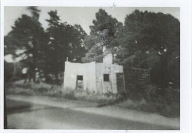
Photograph - Oat and Grain Store, 1961
... The oat and grain store was positioned opposite Emerald's original police station at 15 Kilvington Drive, on what is now the railway property near Puffing Billy Playground. ...Kilvington Drive, Emerald, Victoria, 3782, Australia...The oat and grain store was positioned opposite Emerald's original police station at 15 Kilvington Drive, on what is now the railway property near Puffing Billy Playground. ...The oat and grain store was positioned opposite Emerald's original police station at 15 Kilvington Drive, on what is now the railway property near Puffing Billy Playground. The grain store was first built in the 1920s, used by Clyde Stapleton in the 1940s, and demolished not long after this photograph was taken in 1961.Oat and grain stores were important to horse-based transportation, the agriculture industry, and food supply until the mid-20th century.The main item is the black and white photograph, with a printed annotation pasted to the reverse; there is also a larger sepia copy. Both depict a stone or painted brick building by the side of the road, with a wooden annexe at the rear. There is no door on the building, which stands beside a road. In the background are several trees. The reverse of the sepia version has Kodak logos and handwritten pen annotations; the black and white copy has, besides the printed annotations, a handwritten title and accession number.Black & White, Reverse: "165 Oat & grain Store / P00529 / 165 Oat and grain store, built in the 1920s opposite the police / station (site of [crossed out: present playground] [handwritten: railway property]): [crossed out: Clive] [handwritten: Clyde] Stapleton used to come / from the city to shoe horses here in the 1940s/ The phootgraph was / taken in 1961 before the store was demolished. / [crossed out, handwritten: Legges used it as a store]" Sepia, Reverse: "Gary Steven's gave me this photo. 1961. / Original Oat & Grain Store / Clive Stapleton shod horses here / when he came up from Town. / Opposite Police Station (where the playground is)"agriculture, transport, 1960s, stapleton family -
 Emerald Museum & Nobelius Heritage Park
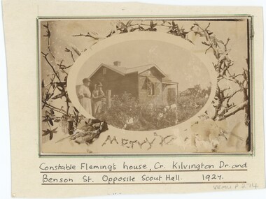
Photograph - Constable Fleming's House, 1927
... This photograph was taken at what is now 14 Kilvington Drive, across the road from Emerald Scout Hall and at the corner with Benson Street. ...14 Kilvington Drive, Emerald, Victoria, 3782, Australia...This photograph was taken at what is now 14 Kilvington Drive, across the road from Emerald Scout Hall and at the corner with Benson Street. ...This photograph was taken at what is now 14 Kilvington Drive, across the road from Emerald Scout Hall and at the corner with Benson Street. Constable Lawrence Joseph Fleming (1876-1967), the house's occupant, worked in the district for 19 years from November 1915 until his retirement in June 1934. He was a respected local figure, with tributes given by other local figures when he retired. While this house is discussed as belonging to Constable Fleming, Fleming himself lived in the old police station further up Kilvington Drive. This house was occupied separately by his wife Jessie Fleming for many years, and she may be one of the women in the photographz. According to Graeme Legge, Constable Fleming's distinctive white horse inspired the name for Whitehorse Road; this story is apocryphal, as Whitehorse Road is generally agreed to have been named for the White Horse Hotel, which was named for the horse of a Captain Elgar local to the Box Hill area.Constable Fleming was a significant and respected figure in the Emerald community for many years; this home was not his main residence, but was an important part of his family's life.This item is a sepia photograph mounted on card. Beneath the photograph, a caption is handwritten on the card in black pen; an accession number is written on the obverse and reverse in pencil. The photograph is positioned in an oval frame surrounded by branches, leaves, and birds; below the photograph a message is written in branches, though the second word is obstructed. In the photograph is a wooden weatherboard house with an angled roof and shaded window; further back appears to be an uncompleted frame of a house. Two women are standing next to a fence.The foreground filled with plants.Caption: "Constable Fleming's house, Cr. Kilvington Dr. and / Benson St. Opposite Scout Hall. 1927" In Photograph: "Merry [illegible]"polce, emerald, 1920s -
 Emerald Museum & Nobelius Heritage Park
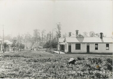
Photograph, Station Rd, Emerald, c. 1907
... At this time it was relatively new - the second centre of Emerald, around Kilvington Drive, mostly materialised thanks to the location of the railway station. ...Kilvington Drive, Emerald, Victoria, Australia...At this time it was relatively new - the second centre of Emerald, around Kilvington Drive, mostly materialised thanks to the location of the railway station. ...There are seven other copies of this photograph in our collection, mostly differing in the placement of the label and the cropping of the photograph. This is itself a copy of the original. One of these copies is also accessioned as VEMUP0456.2. This c. 1907 photograph was taken from the intersection of Beaconsfield Road (now Kilvington Drive) and Station Road (now Puffing Billy Place), looking towards Emerald Railway Station. It looks past the Emerald Coffee Palace, a significant establishment serving coffee, wine, and more - a room in the back was even used as a visiting doctor's surgery. The Coffee Palace was, at the time, owned by the O'Connor family and run by Mrs Greatorex. At this time it was relatively new - the second centre of Emerald, around Kilvington Drive, mostly materialised thanks to the location of the railway station. The location of the railway is visible, but from this angle the station and tracks are not visible. Note the posts in front of the Palace - used to tie horses in this time before cars became dominant. There are elevated wires visible running along the left side of the street, which resemble power lines but at this time are more likely to have instead been telegraph cables. This copy was framed in the donor's home after being gifted to him by its previous owner, who bought it from an op-shop in Melbourne.This photograph recounts the growth of Emerald's second town centre around the railway station.This item is a large, slightly yellowed, black and white copy of an older photograph. It depicts an unpaved street leading down a hill to a gate and fence, with several shops to either side. There is a lamp post on the street corner on the right, and a telegraph line running along the left side. In the background, the slope rises back up to a hill with fields and scattered trees.Bottom-right: "STATION RD. EMERALD" Building in the photograph: "EMERALD COFFEE PALACE"emerald coffee palace, emerald, 1900s, commerce -
 Emerald Museum & Nobelius Heritage Park
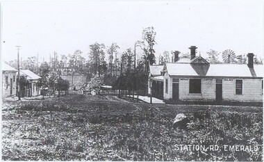
Photograph, Station Rd, Emerald, c. 1907
... At this time it was relatively new - the second centre of Emerald, around Kilvington Drive, mostly materialised thanks to the location of the railway station. ...Kilvington Drive-Heroes Avenue Corner, Emerald, Victoria, Australia...At this time it was relatively new - the second centre of Emerald, around Kilvington Drive, mostly materialised thanks to the location of the railway station. ...There are seven other copies of this photograph in our collection, mostly differing in the placement of the label and the cropping of the photograph. This is itself a copy of the original. One of these copies is also accessioned as VEMUP0456.2. This c. 1907 photograph was taken from the intersection of Beaconsfield Road (now Kilvington Drive) and Station Road (now Puffing Billy Place), looking towards Emerald Railway Station. It looks past the Emerald Coffee Palace, a significant establishment serving coffee, wine, and more - a room in the back was even used as a visiting doctor's surgery. The Coffee Palace was, at the time, owned by the O'Connor family and run by Mrs Greatorex. At this time it was relatively new - the second centre of Emerald, around Kilvington Drive, mostly materialised thanks to the location of the railway station. The location of the railway is visible, but from this angle the station and tracks are not visible. While the annotation lists that the photograph was taken in 1889, the visibility of a gate (contra the annotation) and existence of this second town centre - which grew around the station - suggests that other sources lisitng 1907 are closer to accuracy. Note the posts in front of the Palace - used to tie horses in this time before cars became dominant. There are elevated wires visible running along the left side of the street, which resemble power lines but at this time are more likely to have instead been telegraph cables.This photograph recounts the growth of Emerald's second town centre around the railway station.This item is a black and white copy of an older photograph. It depicts an unpaved street leading down a hill to a gate and fence, with several shops to either side. There is a lamp post on the street corner on the right, and a telegraph line running along the left side. In the background, the slope rises back up to a hill with fields and scattered trees.Bottom-right: "STATION RD. EMERALD" Building in the photograph: "EMERALD COFFEE PALACE" Reverse: "Coffee Palace was guest house / Note no gates this was before the railway Puffing Billy came through. / Note posts to tie horses to outside the palace. / O'Connors owned Coffee Palace. / Windmill in back of Palace - bore for water. 1889."emerald coffee palace, emerald, commerce, 1900s -
Emerald Museum & Nobelius Heritage Park
Photograph - Joe, Nell & Kevin Teasdale, 1941, 1941
... ...Kilvington Drive...Photograph of Bill Teasdale with his parents Joe and Nell Teasdale in front of their shop in Beaconsfield Road (now Kilvington Drive). They are located in front of the present-day Emerald Bakery. ...Photograph of Bill Teasdale with his parents Joe and Nell Teasdale in front of their shop in Beaconsfield Road (now Kilvington Drive). They are located in front of the present-day Emerald Bakery. ...The Teasdale family were shop proprietors in the 1940s in Emerald. Kevin Teasdale has written extensively about Emerald in that period. His writings are contained with photographs in his family folder in Filing Cabinet 6C.Black and white rectangular photograph printed on matte photographic paper. Photograph of Bill Teasdale with his parents Joe and Nell Teasdale in front of their shop in Beaconsfield Road (now Kilvington Drive). They are located in front of the present-day Emerald Bakery. The Grady's shop and the Legge's shop are in the background on the present-day site of the Emerald Fruit Shop and other shops to the corner of Heroes Avenue. Year: 1941On back of photo written in biro (presumably by Kevin Teasdale): Joe, Nell and Kevin Teasdale in front of their Beaconsfield Rd (now Kilvington Dve) shop. 1941 Location: where people now drink coffee (in front of the Emerald Bakery of 2012. The Grady's dwelling and Legges' shop are in the background. They have been replaced by today's (2012) fruit shop and other shops to the corner of Heroes Avenue.kevin teasdale, 1940s, joe and nell teasdale, kilvington drive -
 Emerald Museum & Nobelius Heritage Park
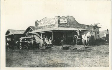
Photograph - W. M. Anderson Store, 1920s-40s
... Anderson's store on the corner of what is now Kilvington Drive and Heroes Avenue. At the time, these may have respectively been Beaconsfield Road and, according to the label, Avenue of Honor. ...Kilvington Drive, Emerald, Victoria, Australia...Anderson's store on the corner of what is now Kilvington Drive and Heroes Avenue. At the time, these may have respectively been Beaconsfield Road and, according to the label, Avenue of Honor. ...This photograph depicts W. M. Anderson's store on the corner of what is now Kilvington Drive and Heroes Avenue. At the time, these may have respectively been Beaconsfield Road and, according to the label, Avenue of Honor. Anderson's store is believed to have been built by the Stillwell family in 1921, but Anderson had his store at least from 1923 and therefore likely owned it from the point of its first construction. By the late 1940s, Anderson's had become Legge's General Store. It is difficult to determine precisely when within that range this photograph was taken. We believe Anderson's store was on the corner now occupied by Grace and Louie Booksellers. Some of the people in the photograph include Bill Anderson with Albert Legge, and Leo Hirst - employees of Anderson - in the center-left, and George Davey standing in the cart.This photograph captures a now-unfamiliar store in a familiar part of old Emerald, documenting the changes to the commercial landscape over the past century.This black and white photograph depicts a store on a street corner, with a porch covering the walkway outside and several signs on the building, along with writing on the end of the porch covering. In the left of the frame is a car, with two dogs, a horse, and a man surrounding it; in the right, a man strands on a horsecart drawn by a white horse. In the center-left are three men wearing aprons with a child besides them, while in the center a woman and child stand in the doorway. In the background, other buildings continue down both streets. The reverse is annotated, and has six rectangular artefacts where adhesive was once applied. A section of handwriting is illegible due to damage, but likely read 'Heroes Avenue' or 'Avenue of Honour'.Reverse: "Built in 1921 / Cr [illegible] & Kilvington / Cross reference 56" Obverse: In Photograph Sign, Left: "W. M. ANDERSON" In Photograph Sign, Right: "THE / STORE" In Photograph, Porch: "W.M.ANDERSON [illegible]"emerald, commerce, 1920s, 1930s, 1940s -
 Emerald Museum & Nobelius Heritage Park
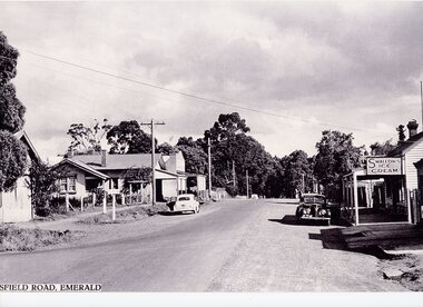
Photograph - Emerald-Beaconsfield Road 1940s, 1940s
... This photograph was taken on Beaconsfield Road in Emerald (now Kilvington Drive) looking from Emerald Main Street towards the train line. ...Kilvington Drive, Emerald, Victoria, Australia...This photograph was taken on Beaconsfield Road in Emerald (now Kilvington Drive) looking from Emerald Main Street towards the train line. ...This photograph was taken on Beaconsfield Road in Emerald (now Kilvington Drive) looking from Emerald Main Street towards the train line. In the right of the image is the Teasdale store, on the location now used for storage by the Emerald Village Bakery. The store was owned by Joseph and Nell Teasdale, with Joseph's brother Edward operating a leatherworking business behind the store. Joseph and Nell's son, Kevin, suggested that what is now called Stapleton Walk instead be named "Forge Lane or Forge Walk," rather than solely representing Charles Stapleton's business across the lane from the Teasdales. On the left of the image is a sign denoting a school - possibly a back entrance to the nearby Emerald Primary School (number 3381) through the school oval. There are also other stores on the left, including what appears to be a newsagents. This is a copy of the original photograph; parts of the label have been lost in the process.This photograph depicts Emerald in the 1940s, showing several stores no longer in existence.A black and white photograph centered on an unsealed commercial road with shops on either side. One shop has a sign advertising Swallows Ice Cream, and another the Age and Leader newspapers. 1940s-style cars are parked on either side.Below image (Start cut off): "SFIELD ROAD, EMERALD" (Originally "BEACONSFIELD ROAD, EMERALD")emerald, transport, teasdale family, 1940s, commerce -
 Emerald Museum & Nobelius Heritage Park
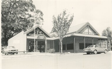
Photograph - Emerald Post Office, c. 1980s
... The brick building, standing on Kilvington Drive, was built by Sandel Construction Pty Ltd, costing approximately $420,000. ...3 Kilvington Drive, Emerald, Melbourne, Victoria, 3782, Australia...The brick building, standing on Kilvington Drive, was built by Sandel Construction Pty Ltd, costing approximately $420,000. ...The first post office in Emerald was opened on December 1899, most likely under the control of David Andrews, the postmaster. Prior to the opening of this post office, mail was reportedly carried by horseback to and from Gembrook to Packenham, where it was then collected by foot every second day. Emerald Post Office found its home in Main Street in 1906, where it remained until the mid 1980s. There, they handled in excess of 15,000 mail items a year. By the 1980s, Emerald had become a popular residential area with a population of more than 4000 people. With this growth, and its services to the surrounding communities of Avonsleigh, Clematis, and Macclesfield, it was considered appropriate to open a new post office building. The brick building, standing on Kilvington Drive, was built by Sandel Construction Pty Ltd, costing approximately $420,000. In the mid 1980s, the post office occupied the entire building. However, it now shares the structure with a local business.This photograph demonstrates the rapid growth of Emerald through the late 1900s. Since the post office stands within the same building today, it also provides an effective measure of how much the surrounding streetscape and business has grown and changed over this time.A black and white photograph of a large brick building. A flagpole stands empty outside the entrance of the building and a small tree grows from the nature strip. A car is parked on the otherwise empty road, while several cars are parked in a small carpark located to the left of the building. In photograph, above entrance: "Emerald / 3782" Reverse, handwritten in ink: "Emerald Post Office"emerald post office, emerald, 1980s -
Emerald Museum & Nobelius Heritage Park
Photograph - 1940 Ford Blitz, 1947-1948
... Photo of Kevin Hogan's truck loaded with wood in present-day Kilvington drive at the present-day location of the Emerald Newsagency. ...The big store on the right is on the corner of Heroes Avenue (& today's Kilvington Drive).'...Photo of Kevin Hogan's truck loaded with wood in present-day Kilvington drive at the present-day location of the Emerald Newsagency. ...This photo, dated 1947-1948, of the truck loaded with wood is evocative of the time when Emerald residents depended on wood for cooking and heating. The donor, Kevin Teasdale, has also pointed out the location of Emerald buildings at that time and at the present day.Black and white, rectangular, printed on gloss photographic paper. Photo of Kevin Hogan's truck loaded with wood in present-day Kilvington drive at the present-day location of the Emerald Newsagency. Frank Hogan is sitting on top of the truck. Photo supplied by Kevin Teasdale.Written on the back of the photograph: 'Kevin Hogan's c1940 Ford Blitz. Photo taken about 1947-8. Frank Hogan on top. Location: Where Emerald Newsagency is today - 2012 The house opposite locates today's fruit shop. The big store on the right is on the corner of Heroes Avenue (& today's Kilvington Drive).'emerald, victoria, australia, memorial avenue, world war i, kevin teasdale -
Emerald Museum & Nobelius Heritage Park
Photograph - Kevin Teasdale, 1940s
... ...Kilvington Drive...Kevin Teasdale 1940s Kilvington Drive Roy Kendall Charlie Stapleton Blacksmiths On back of photo written in biro (presumably by Kevin Teasdale): 'Kevin Teasdale on Roy Kendall's "Timmy". ...The Teasdale family were shop proprietors in the mid 20th century in Emerald. Kevin Teasdale has written extensively about Emerald in that period. His writings are contained with photographs in his family folder in Filing Cabinet 6C. This photograph recalls a time when horses were often used for work and transport and when blacksmiths were needed to shod horses.Black and white rectangular photograph printed on matte photographic paper. A young child (Kevin Teasdale) seated on a horse owned by Roy Kendall and called 'Timmy'. The location is described as the rear section of present day Emerald Bakery coffee lounge. The horse is waiting to be shod by blacksmith, Charlie Stapleton.On back of photo written in biro (presumably by Kevin Teasdale): 'Kevin Teasdale on Roy Kendall's "Timmy". Location: Now occupied by the rear section of the Emerald Bakery's coffee lounge. The horse was waiting to be shod by Charlie Stapleton next door. - across what might aptly be named "Forge Lane". 'kevin teasdale, 1940s, kilvington drive, roy kendall, charlie stapleton, blacksmiths -
Emerald Museum & Nobelius Heritage Park
Postcard - Main Road, Emerald', The Rose Series P3338, 1950s
... On back : Towards Beaconsfield Road" now Kilvington Drive, Main Gembrook Road 1950. On front: The Rose Series P 3338 Main Road, Emerald, Vic...Emerald Victoria Australia roads and streets religious structures and establishments Church of Christ On back : Towards Beaconsfield Road" now Kilvington Drive, Main Gembrook Road 1950. On front: The Rose Series P 3338 Main Road, Emerald, Vic Black and white postcard mounted on cardboard Postcard Main Road, Emerald' The Rose Series P3338 ...Black and white postcard mounted on cardboardOn back : Towards Beaconsfield Road" now Kilvington Drive, Main Gembrook Road 1950. On front: The Rose Series P 3338 Main Road, Emerald, Vicemerald, victoria, australia, roads and streets, religious structures and establishments, church of christ -
 Emerald Museum & Nobelius Heritage Park
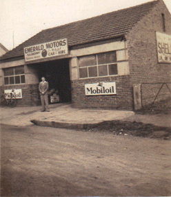
Photograph, Emerald Motors, circa 1930's - 40's
... Sherriff's Garage started in the Blacksmith's shop (originally Stapletons Blacksmith) , cnr. Kilvington Drive (the Beaconsfield Road) and Main Road. ...Sherriff's Garage started in the Blacksmith's shop (originally Stapletons Blacksmith) , cnr. Kilvington Drive (the Beaconsfield Road) and Main Road. ...Sherriff's Garage started in the Blacksmith's shop (originally Stapletons Blacksmith) , cnr. Kilvington Drive (the Beaconsfield Road) and Main Road. Early history of the commercial district of EmeraldSmall sepia photograph depicting Emerald Motors with (possibly) owner Herbie Sherriff standing out front of businessNo inscriptions, but Kodak manufacturing mark on backemerald motors, herbie sherriff, mobiloil signage -
 Emerald Museum & Nobelius Heritage Park
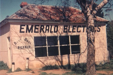
Photograph, Emerald Business - Emerald Electrics, c. 1960's
... Photograph of Edward Teasdale's shop 'Emerald Electric/Boot and shoe repair' situated on Railway Property, Emerald (which is now the Puffing Billy playground on Kilvington Drive, Emerald. ...Photograph of Edward Teasdale's shop 'Emerald Electric/Boot and shoe repair' situated on Railway Property, Emerald (which is now the Puffing Billy playground on Kilvington Drive, Emerald. Retail district history edward teasdale emerald commercial distric Handwritten on back: Donation from Kaye Ure nee Nolan Taken early 1960's C Taken from a slide Original Bootmaker's shop owned by Edward Teadale Railway leasehold property Colour photograph of Emerald Electrics Emerald Business - Emerald Electrics Photograph ...Photograph of Edward Teasdale's shop 'Emerald Electric/Boot and shoe repair' situated on Railway Property, Emerald (which is now the Puffing Billy playground on Kilvington Drive, Emerald. Retail district historyColour photograph of Emerald Electrics Handwritten on back: Donation from Kaye Ure nee Nolan Taken early 1960's C Taken from a slide Original Bootmaker's shop owned by Edward Teadale Railway leasehold propertyedward teasdale, emerald commercial distric -
 Emerald Museum & Nobelius Heritage Park
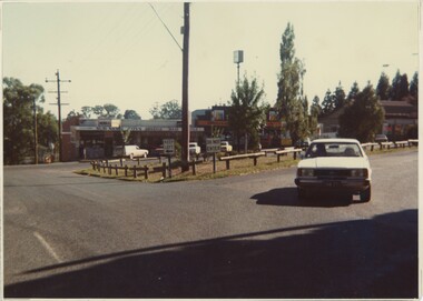
Photograph - Emerald North End 1986 Newsagent, 1986
... This photo was taken facing north-east on the intersection of Main Street, Kilvington Drive, and Ferres Street in Emerald. Visible in the background of the photograph is the Emerald Newsagency, now occupied by Bell Real Estate....This photo was taken facing north-east on the intersection of Main Street, Kilvington Drive, and Ferres Street in Emerald. Visible in the background of the photograph is the Emerald Newsagency, now occupied by Bell Real Estate. ...This photo was taken facing north-east on the intersection of Main Street, Kilvington Drive, and Ferres Street in Emerald. Visible in the background of the photograph is the Emerald Newsagency, now occupied by Bell Real Estate.This image demonstrates the degree to which a central road, such as Main Street, can change over a span of fifty years.This colour photograph features a row of shops and several parked cars. In the middle of the concrete road is a large green island, fenced in by low wooden logs. Near the centre of the image is a tall telephone pole, and to the right in the foreground is a light blue car.Reverse, pencil: "1986"1980s, emerald -
Emerald Museum & Nobelius Heritage Park
Plan - Roundabout Plan, Shire of Sherbrooke, 1989
... Shire of Sherbrooke Emerald Township Roundabouts Belgrave-Gembrook Road and Emerald-Monbulk Road Intersections|Shire of Sherbrooke Emerald Township Roundabouts Belgrave-Gembrook Road and Ferres Road/Kilvington Drive Intersections|Shire of Sherbrooke Emera...Emerald Victoria Australia traffic road construction plans Shire of Sherbrooke Victoria Australia Emerald Township Roundabouts Shire of Sherbrooke Emerald Township Roundabouts Belgrave-Gembrook Road and Emerald-Monbulk Road Intersections|Shire of Sherbrooke Emerald Township Roundabouts Belgrave-Gembrook Road and Ferres Road/Kilvington Drive Intersections|Shire of Sherbrooke Emera Photocopy of plan for roundabouts; Scale 1:200Paper Plan Roundabout Plan Shire of Sherbrooke ...Plans for roundabouts constructed by Shire of Sherbrooke (see Inscriptions for locations) approximately 1990.Photocopy of plan for roundabouts; Scale 1:200PaperShire of Sherbrooke Emerald Township Roundabouts Belgrave-Gembrook Road and Emerald-Monbulk Road Intersections|Shire of Sherbrooke Emerald Township Roundabouts Belgrave-Gembrook Road and Ferres Road/Kilvington Drive Intersections|Shire of Sherbrooke Emeraemerald, victoria, australia, traffic, road construction, plans, shire of sherbrooke victoria australia, emerald township roundabouts -
 Emerald Museum & Nobelius Heritage Park
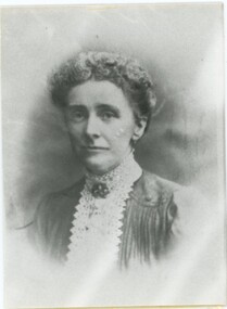
Photograph - Print of photographic portrait of Mrs Florrie Meyenn, 1900s
... She ran one of the first guest houses in Emerald, Nottingham House, situated on the now Kilvington Drive, near the Scout Hall. Nursery workers used to board there. ...She ran one of the first guest houses in Emerald, Nottingham House, situated on the now Kilvington Drive, near the Scout Hall. Nursery workers used to board there. ...This photographic portrait is of Mrs Florrie Meyenn (nee Middleton), wife of a German seaman. She ran one of the first guest houses in Emerald, Nottingham House, situated on the now Kilvington Drive, near the Scout Hall. Nursery workers used to board there. Mrs Meyenn later married Mr Ned Horwood.This photograph of the proprietor of one of the earliest guest houses in Emerald recalls Emerald's early history of guesthouses.Black and white studio photographic print (head and shoulders) of Mrs Florrie Meyenn. In clear plastic packet.On back top right, blue label handwritten (recent): 'P4' On back at bottom handwritten (recent): 'P401002' On outside of packet, typed: '7892-1 #150 * Positive / HERITAGE SPRING '88 / LITHOCRAFT BLUE 27/7/88 PM' Underneath typing on packet, handwritten: 'P. 40-61 100%'nottingham house, guest houses, meyenn -
Emerald Museum & Nobelius Heritage Park
Document - Heritage Report - Emerald Bakery, Graeme Butler & Associates, 2001
... Detailed assessment of the significance of the old Emerald Bakery, located at the rear of the Commonwealth Bank, Kilvington Drive, Emerald. The assessment was made by Graeme Butler & Associates at the request of Cardinia Shire Council, at the time relocation of the bakery was being considered in the event of closure o0f the Commonwealth Bank. ...Detailed assessment of the significance of the old Emerald Bakery, located at the rear of the Commonwealth Bank, Kilvington Drive, Emerald. The assessment was made by Graeme Butler & Associates at the request of Cardinia Shire Council, at the time relocation of the bakery was being considered in the event of closure o0f the Commonwealth Bank. ...Detailed assessment of the significance of the old Emerald Bakery, located at the rear of the Commonwealth Bank, Kilvington Drive, Emerald. The assessment was made by Graeme Butler & Associates at the request of Cardinia Shire Council, at the time relocation of the bakery was being considered in the event of closure o0f the Commonwealth Bank. The recommendation was not to relocate. The bakery was originally operated by W. Moffat and subsequently by Robert McLean.11 page unbound report, printed single-sided with black and white photographsemerald, victoria, australia, bakeries, historic buildings, emerald bakery, w. moffatt, robert mclean, national trust of australia (vic), graeme butler & associates -
 Emerald Museum & Nobelius Heritage Park
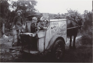
Photograph - Joy and Keith Rainey on the Baker's Cart, c. Late 1940s
... Wilson, the baker at Emerald - the old bakery was once at what is now the rear of 1 Kilvington Drive....Wilson, the baker at Emerald - the old bakery was once at what is now the rear of 1 Kilvington Drive. This photograph depicts members of a significant local family. ...This photograph depicts Joy Rainey (leftmost), Keith Rainey (rightmost), and another child. Joy and Keith look slightly younger than they do in another photograph from 1951, so it is likely this photograph was taken in the late 1940s. They are riding a cart owned by H. Wilson, the baker at Emerald - the old bakery was once at what is now the rear of 1 Kilvington Drive.This photograph depicts members of a significant local family.This item is a black and white photograph. The reverse features printed technical information and handwritten annotations. In the photograph are three children in a horsecart; a girl sits on the edge of the cart on the left, while two boys are on the seat looking over their shoulders to face the camera. The cart has writing on the side advertising the Emerald bakery; it is pulled by a single horse. The immediate background features a dirt road proceeding into trees; in the far background a wooded hill rises behind the cart.Reverse, Handwritten: "RAINEY FAMILY / AVONSLEIGH" Reverse, Printed: "10 763 096--B~1.JPG 1 25.09.05 05.10.06" Obverse, side of horsecart: "PHONE 38 / H. WILSON / BAKER / EMERALD" rainey family, joy rainey, keith rainey, 1940s, avonsleigh -
Emerald Museum & Nobelius Heritage Park
Functional object - Key to the Emerald Coffee Palace, Unknown maker, 1900s
... This key was the front door key of the Emerald Coffee Palace which was situated on Beaconsfield Road (now Kilvington Drive). Built in 1901. Demolished in 1961. ...This key was the front door key of the Emerald Coffee Palace which was situated on Beaconsfield Road (now Kilvington Drive). Built in 1901. Demolished in 1961. ...This key was the front door key of the Emerald Coffee Palace which was situated on Beaconsfield Road (now Kilvington Drive). Built in 1901. Demolished in 1961. The key was donated by Vera Madigan who was the daughter of T. J. Madigan who demolished the Palace in 1967 to re-develop the site. T. J. Madigan was Emerald's butcher from late 1920s through to the 1940s. The Coffee Palace had accommodation and also had the attraction of being able to serve alcohol.Key. Metal. Leather label inscribed with the key's provenance details attached to key with leather plait. The key dates from 1900s whilst the leather label was added more recently.key, madigan, coffee palace, emerald, victoria, australia, 1900s -
 Emerald Museum & Nobelius Heritage Park
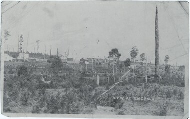
Photograph, View at Emerald, 1898
... Notes associated with this photograph indicate both that it was taken at the end of Heroes Avenue and that it was taken on 'Monbulk Road' - while these notes might simply be incorrect, it may also indicate that this may have been taken at what is now the intersection of Heroes Avenue and either Beaconsfield-Emerald Road or Kilvington Drive, potentially at the time under a different or incorrect name. ...Notes associated with this photograph indicate both that it was taken at the end of Heroes Avenue and that it was taken on 'Monbulk Road' - while these notes might simply be incorrect, it may also indicate that this may have been taken at what is now the intersection of Heroes Avenue and either Beaconsfield-Emerald Road or Kilvington Drive, potentially at the time under a different or incorrect name. ...Notes associated with this photograph indicate both that it was taken at the end of Heroes Avenue and that it was taken on 'Monbulk Road' - while these notes might simply be incorrect, it may also indicate that this may have been taken at what is now the intersection of Heroes Avenue and either Beaconsfield-Emerald Road or Kilvington Drive, potentially at the time under a different or incorrect name. This photograph was taken in 1898 when Emerald was much less densely occupied as a growing town amidst Nobelius' nursery.This photograph captures a side of Emerald that no longer exists, looking at the growing town from an outside that has long since been encompassed by the town.A black and white photograph of a landscape, with various buildings in the background and the road in the foreground. The photograph is quite small, which means scans of it are at quite a low resolution. There are several markings and copies of fold marks preserved from the original.Label: "VIEW AT EMERALD" Later note, rear of copy: "Heroes Ave end. 1898."emerald, 1890s -
 Emerald Museum & Nobelius Heritage Park
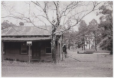
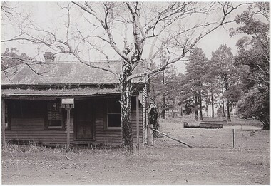
Photograph - Emerald Grocery Near Station, 1901
... Anderson moved to a new and more lasting location - the corner of Kilvington Drive and Heroes Avenue, where until recently a bookshop was located - at the start of the 1920s, but this older store was in a different location closer to the station. ...Anderson moved to a new and more lasting location - the corner of Kilvington Drive and Heroes Avenue, where until recently a bookshop was located - at the start of the 1920s, but this older store was in a different location closer to the station. ...The store in this image belonged to W. M. Anderson, near an Emerald Station which as of 1901 would have been open for less than a year. Anderson moved to a new and more lasting location - the corner of Kilvington Drive and Heroes Avenue, where until recently a bookshop was located - at the start of the 1920s, but this older store was in a different location closer to the station. Two other photos of the same scene are in the collection: VEMUP1011.2 is identical, and VEMUP1011.1 is from a different angle.This image captures an important Emerald institution from the turn of the century, displaying the nature of the town at that time.This black and white photograph features a wooden shop with a corrugated steel roof and porch awning. The shop takes up the left half of the photograph, while the landscape on the right half continues past a wire fence to a flat field, with trees in the far background. In the centre of the foreground, a tree with few leaves stands in front of the building, between it and the road the photographer is standing on. The photograph is printed on modern photograph paper.Reverse, Pen: "Emerald Grocery, Anderson's 1901 Near Station" Reverse, Pencil: "EMERALD GROCERY"emerald, commerce, 1900s -
 Emerald Museum & Nobelius Heritage Park
Photograph - Emerald Grocery Near Station, 1901
... Anderson moved to a new and more lasting location - the corner of Kilvington Drive and Heroes Avenue, where until recently a bookshop was located - at the start of the 1920s, but this older store was in a different location closer to the station. ...Anderson moved to a new and more lasting location - the corner of Kilvington Drive and Heroes Avenue, where until recently a bookshop was located - at the start of the 1920s, but this older store was in a different location closer to the station. ...The store in this image belonged to W. M. Anderson, near an Emerald Station which as of 1901 would have been open for less than a year. Anderson moved to a new and more lasting location - the corner of Kilvington Drive and Heroes Avenue, where until recently a bookshop was located - at the start of the 1920s, but this older store was in a different location closer to the station. Two other photos of the same scene are in the collection: VEMUP1011 is identical, and VEMUP1011.1 is from a different angle.This image captures an important Emerald institution from the turn of the century, displaying the nature of the town at that time.This black and white photograph features a wooden shop with a corrugated steel roof and porch awning. The shop takes up the left half of the photograph, while the landscape on the right half continues past a wire fence to a flat field, with trees in the far background. In the centre of the foreground, a tree with few leaves stands in front of the building, between it and the road the photographer is standing on. The photograph is printed on modern photograph paper.Reverse, Pencil: "EMERALD GROCERY"emerald, commerce, 1900s -
 Emerald Museum & Nobelius Heritage Park
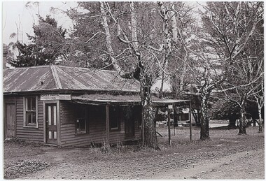
Photograph - Emerald Grocery Near Station, 1901
... Anderson moved to a new and more lasting location - the corner of Kilvington Drive and Heroes Avenue, where until recently a bookshop was located - at the start of the 1920s, but this older store was in a different location closer to the station. ...Anderson moved to a new and more lasting location - the corner of Kilvington Drive and Heroes Avenue, where until recently a bookshop was located - at the start of the 1920s, but this older store was in a different location closer to the station. ...The store in this image belonged to W. M. Anderson, near an Emerald Station which as of 1901 would have been open for less than a year. Anderson moved to a new and more lasting location - the corner of Kilvington Drive and Heroes Avenue, where until recently a bookshop was located - at the start of the 1920s, but this older store was in a different location closer to the station. Two other photos of the same scene are in the collection: VEMUP1011 and VEMUP1011.2 are identical copies of a different angle than that shown in VEMU1011.1/.This image captures an important Emerald institution from the turn of the century, displaying the nature of the town at that time.This black and white photograph features a wooden shop with a corrugated steel roof and porch awning. The shop is viewed from an angle, with its side and front taking up the left half of the photograph, while on the right side a dirt road continues out of frame and a flat, tree-scattered landscape stands between this building and the next building along the road. Two trees stand in front of the building, between it and the road the photographer is standing on. The photograph is printed on modern photograph paper.Reverse, Pen: "Emerald Grocer Mr Anderson Station St Emerald / 1901" Obverse, sign on building in photograph: "Cycle Parts / Repairs / Saddlery"emerald, 1900s, commerce -
 Emerald Museum & Nobelius Heritage Park
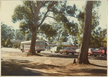
Photograph - Traffic on Main Road Opposite Murphys Way Kilvington Intersection 1979, 1979
... This photo was taken facing south-east on the intersection of Main Street, Kilvington Drive, and Ferres Street in Emerald. Visible in the background of the photograph are the Emerald Pharmacy (now the Emerald Wellness Pharmacy) and the Post Office (now Melbourne Pathology). ...This photo was taken facing south-east on the intersection of Main Street, Kilvington Drive, and Ferres Street in Emerald. Visible in the background of the photograph are the Emerald Pharmacy (now the Emerald Wellness Pharmacy) and the Post Office (now Melbourne Pathology). ...This photo was taken facing south-east on the intersection of Main Street, Kilvington Drive, and Ferres Street in Emerald. Visible in the background of the photograph are the Emerald Pharmacy (now the Emerald Wellness Pharmacy) and the Post Office (now Melbourne Pathology). Alongside the traffic on the road in front of the shopfronts, a US Bus Lines coach is parked. US Bus Lines, initially the Belgrave United Motor Service, operated in Melbourne between 1921 and 2009 when it was acquired by Ventura. The likely route it may have been following was the 695 between Belgrave and Gembrook, which continues to operate along Main Street and Belgrave/Gembrook Road.This image demonstrates the degree to which a central road, such as Main Street, can change over a span of fifty years.This colour photograph features a busy street lined with greenery. In the background, a row of shops is obscured by traffic of cars and a waiting bus. In the foreground of the image, slightly obscuring the cars and buildings, stand two tall trees. The tree on the left is slightly shorter and its branches and leaves fill the upper third of the image. On the photograph's reverse are a few handwritten notes.Reverse, handwritten in ink, crossed out: "Outside Ladders / Emerald 1979" Reverse, handwritten in pencil: "OUTSIDE REECE" emerald, 1970s -
 Emerald Museum & Nobelius Heritage Park
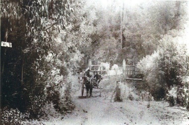
Photograph, Emerald Police - Constable Fleming
... His house which also served as the police station still exists in Kilvington Drive, Emerald. The back yard contained a lock-up for prisoners. ...His house which also served as the police station still exists in Kilvington Drive, Emerald. The back yard contained a lock-up for prisoners. ...FLEMING, Lawrence Joseph, (b.1876 - d. 1967) Police Reg. No. 5974 served with the Emerald Police from 08/11/1915 - 06/09/1934 as 1st. Constable. Lawrence Joseph Fleming was a veteran of the Boer War. He came to Emerald after his discharge from the Australian Army. He joined the police force, travelling on horseback to cover an area from Gembrook, Cockatoo and Emerald, through to Monbulk and Belgrave. His house which also served as the police station still exists in Kilvington Drive, Emerald. The back yard contained a lock-up for prisoners. He served as a policeman in Emerald for 19 years. When he retired, around 1928 - 30, Constable Fleming bought the Collis farm in Pinnocks Road, which at the time extended right down to Telopea Road. He died in Ferntree Gully hospital at the age of 91 years on the 12 June 1967. (as researched by C. Britton)A rare photograph of 1st Constable Lawrence Joseph Fleming - Emerald PoliceCopy of photograph depicting Constable Fleming on horseback MonbulkOn back, handwritten: 'Constable Flemming at Bayne's bridge Monbulk (please note incorrect spelling of Fleming. emerald police, lawrence joseph fleming
