Showing 436 items matching "orbost snowy-river"
-
 Orbost & District Historical Society
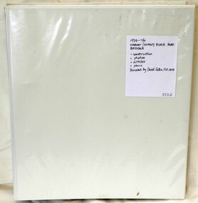
folder, Orbost Bridges - Snowy River Road Bridges, 1974 1976
... Orbost Bridges - Snowy River Road Bridges...Orbost bypass road design. This was a major project involving not only a new bridge over the Snowy River (including Lochiel Lagoon), but other bridges over Ashby’s Gulch and Watt’s Gulch. ...A white plastic folder - Orbost Bridges - Snowy River Road Bridges. it contains newspaper articles, booklets, photographs and documents relating to the construction of the Snowy River Road Bridge in 1974 -1976....on front cover - 1974 - 76 ORBOST / SNOWY RIVER ROAD BRIDGES * construction * photos * articles * plans Donated by David Jellie Oct 2015...Orbost Bridges - Snowy River Road Bridges folder Jellie, David ...This folder was compiled in October 2015 from documents, magazines. papers and photographs donated by David Jellie, engineer in charge 1974 - 1976. In early 1974, as an Engineer with the Country Roads Board, David came to Orbost as the Supervising Engineer for the construction of the new bridges which were part of an 8.4km Orbost bypass road design. This was a major project involving not only a new bridge over the Snowy River (including Lochiel Lagoon), but other bridges over Ashby’s Gulch and Watt’s Gulch. These new bridges were opened in November 1976 with the unveiling of a plaque on the eastern end of the $2.4M Snowy River Bridge. (ref. May Leatch)This item is a useful reference tool on the construction history of the Snowy River Road bridges.A white plastic folder - Orbost Bridges - Snowy River Road Bridges. it contains newspaper articles, booklets, photographs and documents relating to the construction of the Snowy River Road Bridge in 1974 -1976.on front cover - 1974 - 76 ORBOST / SNOWY RIVER ROAD BRIDGES * construction * photos * articles * plans Donated by David Jellie Oct 2015snowy-river-bridges jellie-david -
 Orbost & District Historical Society
Photograph - Orbost photographs, c.1950s
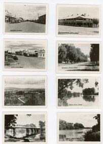
... Orbost...Snowy River...These appear to be photographs of Orbost and the Snowy River taken in the 1950s. ...3362.1 Commonwealth Hotel, Orbost 3362.2 Nicholson Street Orbost 3362.3 Memorial Avenue, Orbost 3362.4 Nicholson Street, Orbost 3362.5 Snowy River, Orbost, with bridge 3362.6 Orbost from Grandview 3362.7 Snowy River at Orbost 3362.8 Snowy River and Bridge at Orbost ...Orbost Snowy River 3362.1 Commonwealth Hotel, Orbost 3362.2 Nicholson Street Orbost 3362.3 Memorial Avenue, Orbost 3362.4 Nicholson Street, Orbost 3362.5 Snowy River, Orbost, with bridge 3362.6 Orbost from Grandview 3362.7 Snowy River at Orbost 3362.8 Snowy River and Bridge at Orbost Eight small b/w photographs of Orbost township and surrounds. ...These appear to be photographs of Orbost and the Snowy River taken in the 1950s. These photographs are significant because they are a record of Orbost and surrounds in c. 1950s. Eight small b/w photographs of Orbost township and surrounds. All photos have captions printed in black ink onto the photos. 3362.1 Commonwealth Hotel, Orbost 3362.2 Nicholson Street Orbost 3362.3 Memorial Avenue, Orbost 3362.4 Nicholson Street, Orbost 3362.5 Snowy River, Orbost, with bridge 3362.6 Orbost from Grandview 3362.7 Snowy River at Orbost 3362.8 Snowy River and Bridge at Orbost orbost, snowy river -
 Lakes Entrance Historical Society
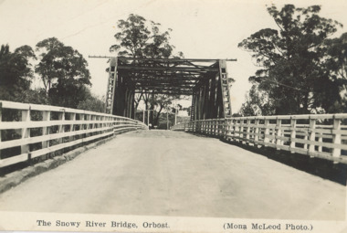
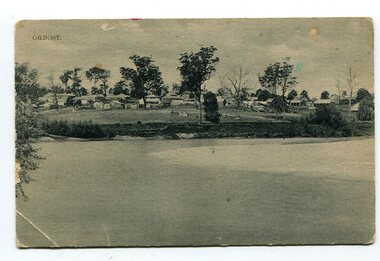
Postcard - Snowy River Orbost c1936, 1936
... Snowy River Orbost c1936...Black and white postcard of timber bridge on the Snowy River Orbost...Central span was washed away in floods in 1934 Rivers Waterways Bridges Black and white postcard of timber bridge on the Snowy River Orbost Postcard Snowy River Orbost c1936 ...Central span was washed away in floods in 1934Black and white postcard of timber bridge on the Snowy River Orbostrivers, waterways, bridges -
 Lakes Entrance Historical Society
Book, Orbost Historical Society Inc, Barns of the Snowy River Orbost, 2006
... Barns of the Snowy River Orbost...Documents the distinctive slatted barns of the Lower Snowy River, Orbost, Victoria. Includes sketch maps, barn plans, history of area and families and personal ineterviews....Barns of the Snowy River Orbost Book Orbost Historical Society Inc. ...Documents the distinctive slatted barns of the Lower Snowy River, Orbost, Victoria. Includes sketch maps, barn plans, history of area and families and personal ineterviews.Ngaire Donald May Leatchland settlement, agriculture, natural disasters, transport -
 Lakes Entrance Historical Society
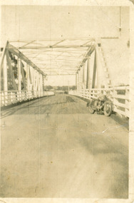
Photograph - Bridge over the Snowy River, Orbost 1940
... Bridge over the Snowy River, Orbost 1940...Black and white photograph showing second Orbost Bridge over the Snowy River, wooden planks, railing and overhead support. ...Orbost, Victoria. Photograph Bridge over the Snowy River, Orbost 1940 ...After 1934 flood damage to second bridge, centre pile was replaced by a truss girder, this survived until 1971 floodBlack and white photograph showing second Orbost Bridge over the Snowy River, wooden planks, railing and overhead support. Motor bike leaning on railing at near end of bridge. Orbost, Victoria.bridges, waterways -
 Orbost & District Historical Society
book, Barns of the Snowy River Orbost, 2006
... Barns of the Snowy River Orbost...The book documents the distinctive slatted barns of the lower Snowy River, Orbost, Victoria. The book was published by the Orbost Historical Society and was written by May Leatch and Ngaere Donald. ...orbost barns-slatted A spiral bound book of 191pp. On the front and back covers are coloured print of the Morgan Barn c 1900, an original watercolour, artist unknown. The book documents the distinctive slatted barns of the lower Snowy River ...This is a book written by a local historian containing historical information pertaining to Orbost and the surrounding district. A spiral bound book of 191pp. On the front and back covers are coloured print of the Morgan Barn c 1900, an original watercolour, artist unknown. The book documents the distinctive slatted barns of the lower Snowy River, Orbost, Victoria. The book was published by the Orbost Historical Society and was written by May Leatch and Ngaere Donald. It contains B/w photographs, drawings and stories of the barns and their histories.history-agriculture-orbost barns-slatted -
 Orbost & District Historical Society
Photograph - Two b/w photographs of Orbost, Rose series, c.1950s
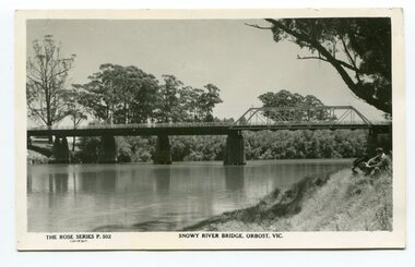
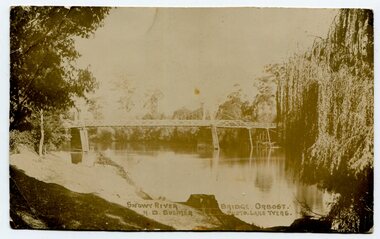
... Orbost...Snowy River...The view from Grand View Lookout is a classic view showing Orbost on the Snowy River in the background. ...2709.1 Orbost from Grand View Heights, Vic. Rose Series P94 2709.2 Snowy River Bridge, Orbost, Vic. ...Orbost Snowy River Grandview Lookout 2709.1 Orbost from Grand View Heights, Vic. ...These two b/w postcards by Rose Series show aspects of Orbost from c.1930s - 1950s. The bridge over the Snowy River appears to be the second bridge constructed in the 1920s and later modified following a flood with the section on the right. The view from Grand View Lookout is a classic view showing Orbost on the Snowy River in the background. These two photos/postcards are significant because they show aspects of Orbost and district from c.1920s - 1950s.2709.1 A b/w postcard/photo showing a panoramic rural view of paddocks in the foreground and trees, river and houses in the background. 2709.2 A b/w postcard/photo of a bridge crossing a river. The bridge appears to be made of wood. It has two quite distinct sections of construction at deck level. 2709.1 Orbost from Grand View Heights, Vic. Rose Series P94 2709.2 Snowy River Bridge, Orbost, Vic. Rose Series P502orbost, snowy river, grandview lookout -
 Orbost & District Historical Society
black and white photographs, 1977
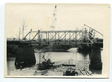
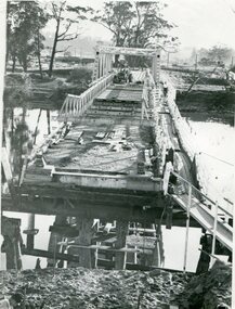
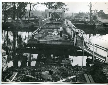
... This is a series of photographs of the demolition of the 1922 bridge across the Snowy River at Orbost. This bridge over the Snowy River was opened on July 4 1922. ...on back - Orbost Snowy River Bridge demolition 1977...Snowy River was opened on July 4 1922. It was constructed in 1922 alongside the previous suspension bridge. Its building was a combined effort of the Victorian Railways and the Country Roads Board at a cost of 35,000 pounds. It was replaced in 1976 by the present bridge after several major floods. This bridge was replaced in 1976 after several major floods. These photographs record the demolition of that bridge. on back - Orbost ...This is a series of photographs of the demolition of the 1922 bridge across the Snowy River at Orbost. This bridge over the Snowy River was opened on July 4 1922. It was constructed in 1922 alongside the previous suspension bridge. Its building was a combined effort of the Victorian Railways and the Country Roads Board at a cost of 35,000 pounds. It was replaced in 1976 by the present bridge after several major floods.This bridge was replaced in 1976 after several major floods. These photographs record the demolition of that bridge.Ten black / white photographs of a road bridge demolition. In the photographs are cranes, one on a barge, and workmenon back - Orbost Snowy River Bridge demolition 1977 -
 Orbost & District Historical Society
black and photograph / postcard, 1.4.1908
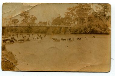
... Cameron-Annie suspension-bridge-Orbost Snowy-River-orbost...This is a photograph of the original Orbost / Snowy River Bridge , a suspension bridge which opened in 1893. ...This is a photograph of the original Orbost / Snowy River Bridge , a suspension bridge which opened in 1893. ...This postcard was sent to Annie Gilbert (Mrs John Gilbert) of Tullagoota, Orbost. It was written by "Grace", probably her sister, Grace Cameron Annie Gilbert was the daughter of John Cameron who selected the first land on the Snowy River flats. This is a photograph of the original Orbost / Snowy River Bridge , a suspension bridge which opened in 1893. It has been taken when the Snowy River was in flood. It is similar to other photographs held in The State Library, Victoria. The Snowy River Mail and Tambo and Croajingolong Gazette Sat 12 Aug 1893 records the opening of this bridge as "the most important public event that has yet been commemorated in Eastern ......The Messrs McLeod, with whom the first settlement of this district is generally associated, took up their residence on the eastern bank of the Snowy River about the year 1841 or 42. The late Mr W. Roadknight and Mr T. T. Stirling took possession of the territory on the western side of the Snowy about 35 years ago. During the occupation of the country by cattle owners, very little progress was made in the way of roads and bridges, and except to the hardy and lexperienced bushman, it might have been generally regarded as inaccessible. About the year 1877, however, the late Mr James Robertson eldest son of Mr James Robertson, of Lochend farm, selected land now occupied by his father, about four miles from Orbost on the west bank of the river, Mr John Cameron visited the. district shortly after a .tour of inspection and returned later with his brothers, James and Alick Gameron, but found that during their absence Mr Ernest Watt had found his way on the scene and pegged out a selection, thus anticipating the advent of the Camerons by about 12 hours. We understand that a Mr Kidd, who selected the property now occupied by Mr W. J. Ross, at Pumpkin Point, was one of the earliest batch of settlers.........."This item is associated with Annie Gilbert (nee Cameron) reported to have been the first white girl to be born in Orbost. It is a pictorial record of the suspension bridge over the Snowy River which has since been replaced twice.A faded black / white postcard of a bridge across a river. There are cattle in the river and the banks are tree-covered.on back - a hand-written letter addressed to Mrs J. Gilbert Tullagoota Orbost.cameron-annie suspension-bridge-orbost snowy-river-orbost -
 Orbost & District Historical Society
black and white photograph, 1971
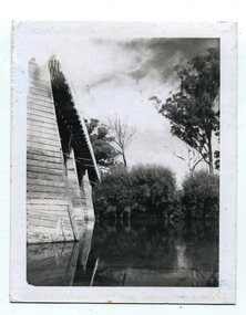
... orbost-snowy-river-bridge-1971 floods-orbost-1971...This photograph shows the second major bridge across the Snowy River at Orbost. The current Snowy River bridge is the fourth to provide a crossing to the township of Orbost. ...Orbost & District Historical Society Ruskin Street Orbost gippsland This photograph shows the second major bridge across the Snowy River at Orbost. ...This photograph shows the second major bridge across the Snowy River at Orbost. The current Snowy River bridge is the fourth to provide a crossing to the township of Orbost. The first, in 1891, lasted just two years before it succumbed to flood waters. The bridge in this photograph was built in the 1920s as a road and rail bridge, and was again partly washed away by flood waters in 1934. After the end of the first World War the Victorian Railways considered an extension of the railhead across the river at Orbost, and in 1922 a new timber and steel girder structure, a joint Country Roads Board — Victorian Railways venture, was built and completed at a cost of £41,000 (the steel girders came from the Flinders Street viaduct reconstruction). Subsequently it was decided not to take the railway across the river, and the bridge was only used by road traffic. It was severely battered by floods during its life. and after the devastating 1971 floods was eventually replaced by the current bridge in 1975. (info from Newletter 54N by John Phillips)This is a pictorial record of the flood damage in 1971 when part of the Snowy River Bridge was washed away.A black / white photograph of a bridge which has been damaged by floodwaters. It shows one end has been washed away.orbost-snowy-river-bridge-1971 floods-orbost-1971 -
 Orbost & District Historical Society
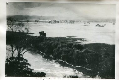
Photograph - Flood, Snowy River, Orbost 1978
... Flood, Snowy River, Orbost 1978......Snowy River...Orbost...The Snowy River can flood over its floodplain at Orbost/Newmerella. There have been wet periods when floods were frequent and covered the floodplain, sometimes causing great disruption to crops and farming, and also to transport. ...Orbost & District Historical Society Ruskin Street Orbost gippsland The Snowy River can flood over its floodplain at Orbost/Newmerella. ...The Snowy River can flood over its floodplain at Orbost/Newmerella. There have been wet periods when floods were frequent and covered the floodplain, sometimes causing great disruption to crops and farming, and also to transport. The 1970s was a wet decade with many floods, the largest one in 1971. This photograph was taken in 1978. Evidence of flood on the Snowy River in 1978. A b/w photograph of a flood scene with trees and the river in the front, a river bank, and a vast area of water in the background. This photograph has been pasted onto a rough cardboard backing. Written below the photograph: Orbost 1978floods, snowy river, orbost -
 Orbost & District Historical Society
black and white photographs, Howard D. Bulmer, first half 20th century
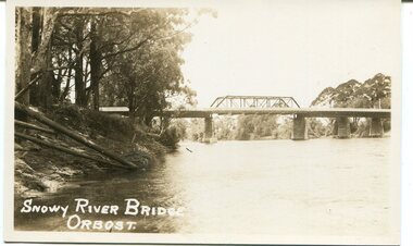
... snowy-river-bridge-orbost...A large black / white photograph of the Orbost Snowy River bridge. There is a large copy as well as a postcard copy in sepia....on front - Snowy River Bridge Orbost H.D. Bulmer - photo - Lake Tyers.... River at Orbost. snowy-river-bridge-orbost on front - Snowy River Bridge Orbost H.D. ...This bridge was built in the 1920s as a road and rail bridge, and was partly washed away by flood waters in 1934. After the end of the first World War the Victorian Railways considered an extension of the railhead across the river at Orbost, and in 1922 a new timber and steel girder structure, a joint Country Roads Board — Victorian Railways venture, was built and completed at a cost of £41,000 (the steel girders came from the Flinders Street viaduct reconstruction). Subsequently it was decided not to take the railway across the river, and the bridge has only been used by road traffic. This is a pictorial record of an early bridge across the Snowy River at Orbost.A large black / white photograph of the Orbost Snowy River bridge. There is a large copy as well as a postcard copy in sepia.on front - Snowy River Bridge Orbost H.D. Bulmer - photo - Lake Tyers.snowy-river-bridge-orbost -
 Orbost & District Historical Society
black and white photograph, first half 20th century
... Orbost Snowy-River-bridge transport-bridge...This is a photograph of the second Snowy River Bridge at Orbost. The section in the central span could have been built after flood damage. ...Snowy River was opened on July 4 1922. It was constructed in 1922 alongside the previous suspension bridge. Its building was a combined effort of the Victorian Railways and the Country Roads Board at a cost of 35,000 pounds. It was replaced in 1976 by the present bridge after several major floods. This bridge was replaced in 1976 after several major floods. Orbost ...This is a photograph of the second Snowy River Bridge at Orbost. The section in the central span could have been built after flood damage. This bridge over the Snowy River was opened on July 4 1922. It was constructed in 1922 alongside the previous suspension bridge. Its building was a combined effort of the Victorian Railways and the Country Roads Board at a cost of 35,000 pounds. It was replaced in 1976 by the present bridge after several major floods.This bridge was replaced in 1976 after several major floods.A black / white photograph / postcard of a bridge over a river. It has what looks like a bo girder in the central section. On the left is the river bank.on front bottom left - "SNOWY RIVER BRIDGE"orbost snowy-river-bridge transport-bridge -
 Orbost & District Historical Society
black and white photographs, February 17 1971
... bailey-bridge orbost-snowy-river-bridge bridge-orbost...After the damage from the February 1971 floods at Orbost when the abutment to the Snowy River road bridge was washed away a Bailey bridge, portable, pre-fabricated, truss bridge, was put into place to ensure town access, the C.R.B. rebuilt the approach to the bridge driving new piles and constructing the Bailey bridge. ...These photographs are pictorial records of a significant event in the history of Orbost. bailey-bridge orbost-snowy-river-bridge bridge-orbost Three black / white photographs of a Bailey bridge being erected across a river. 3245.1 and 3245.2 are the same. black and white photographs Snowy River Mail ...After the damage from the February 1971 floods at Orbost when the abutment to the Snowy River road bridge was washed away a Bailey bridge, portable, pre-fabricated, truss bridge, was put into place to ensure town access, the C.R.B. rebuilt the approach to the bridge driving new piles and constructing the Bailey bridge. They worked late into the night under flood lights to ensure the link from the Orbost township to the Princes Freeway would be open to traffic as soon as possible.These photographs are pictorial records of a significant event in the history of Orbost.Three black / white photographs of a Bailey bridge being erected across a river. 3245.1 and 3245.2 are the same. bailey-bridge orbost-snowy-river-bridge bridge-orbost -
 Orbost & District Historical Society
black and white photographs, C1970
... bridge-Orbost Snowy-River-bridge...These photographs are of the 1922 road bridge across the Snowy River at Orbost. This bridge over the Snowy River was opened on July 4 1922. ...on label on back - "Snowy River Bridge at Orbost 1922 Bridge"...Snowy River was opened on July 4 1922. It was constructed in 1922 alongside the previous suspension bridge. Its building was a combined effort of the Victorian Railways and the Country Roads Board at a cost of 35,000 pounds. It was replaced in 1976 by the present bridge after several major floods. This bridge was replaced in 1976 after several major floods. These photographs are pictorial records of the 1922 brige. bridge-Orbost ...These photographs are of the 1922 road bridge across the Snowy River at Orbost. This bridge over the Snowy River was opened on July 4 1922. It was constructed in 1922 alongside the previous suspension bridge. Its building was a combined effort of the Victorian Railways and the Country Roads Board at a cost of 35,000 pounds. It was replaced in 1976 by the present bridge after several major floods.This bridge was replaced in 1976 after several major floods. These photographs are pictorial records of the 1922 brige.Two small black / white photographs of a road bridge across a river. 3248.1 is a close-up of wooden pylons.on label on back - "Snowy River Bridge at Orbost 1922 Bridge"bridge-orbost snowy-river-bridge -
 Orbost & District Historical Society
black and white photograph, 1920s
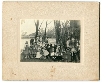
... orbost snowy-river...This photograph is a contemporary record of rural life in Orbost in the early 20th century. orbost snowy-river A black / white photograph of a group of young girls dressed up and posing on the banks of a river. ...The bridge shown in the background was built in the 1920s as a road and rail bridge, and was partly washed away by flood waters in 1934. There is no known history of this item.This photograph is a contemporary record of rural life in Orbost in the early 20th century.A black / white photograph of a group of young girls dressed up and posing on the banks of a river. On the left hand side of the photograph is an older man and on the right is an older lady. In the background is a bridge - the first Snowy River bridge. The photograph is on a cream coloured buff card. orbost snowy-river -
 Orbost & District Historical Society
black and white photograph, Murray Studio, Murray Views, 1934
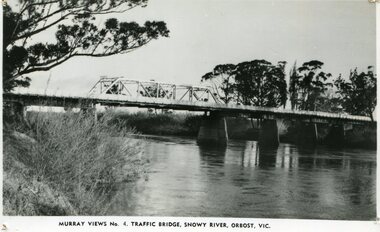
... orbost-snowy-river-bridge...A black / white photograph / postcard of the Snowy River Bridge at Orbost....on front bottom printed - Murray Views No.4 Traffic Bridge , Snowy River, Orbost, Vic.... at Orbost. orbost-snowy-river-bridge on front bottom printed - Murray Views No.4 Traffic Bridge , Snowy River, Orbost, Vic. ...After the flood damage of 1934, the bridge was repaired with a new section in the middle. This bridge remained largely unchanged until its final demolition in 1975 after construction of the new concrete bridge and Orbost by-pass which exists today. This photograph is one of a collection of photographs produced by Murray Views, Gympie. It features eight scenic b/w photographic prints of Orbost and surrounding tourist areas.Photographs like these allowed tourists to send many images of their holiday destination or hometown in the one small package. Fred Murray opened Murray Studios in Gympie in 1906. The postcard and souvenir production side of the business initially covered Gympie and surrounding regions, but Murray expanded the business to include North Queensland, New South Wales and even Adelaide. It was opened under a separate name, Murray Views, in 1929. In 1945 the business was taken over by Murray’s nephews who began postcard folder production. This is a pictorial record of an early bridge across the Snowy River at Orbost.A black / white photograph / postcard of the Snowy River Bridge at Orbost.on front bottom printed - Murray Views No.4 Traffic Bridge , Snowy River, Orbost, Vic.orbost-snowy-river-bridge -
 Orbost & District Historical Society
Photograph - Postcards - Orbost, Rose series, c. 1920s-50s
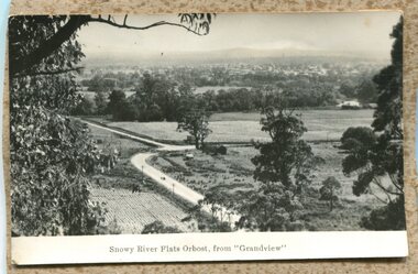
... Orbost...Snowy River...2702.1 Snowy River and Bridge, Orbost has been printed in white onto the bottom of the photograph. 2702.2 Snowy River Flats, Orbost from "Grandview" printed on bottom of photograph. 2702.3 the Rose Series P2711 copyright. ...These three photographs are significant because they not only show aspect of Orbost from c.1920s - c.1950s but were installed in one of the guests houses known as Orbost House. Orbost Snowy River 2702.1 Snowy River and Bridge, Orbost has been printed in white onto the bottom of the photograph. 2702.2 Snowy River Flats, Orbost from "Grandview" printed on bottom of photograph. 2702.3 the Rose Series P2711 copyright. ...These three b/w photographs/postcards were originally installed on a backing board and hung in the kitchen/dining room of Orbost House which was a well-known guest-house in Orbost. They were used in a display to give information about the district to guests and staff. These three photographs are significant because they not only show aspect of Orbost from c.1920s - c.1950s but were installed in one of the guests houses known as Orbost House.Three b/w photographs/postcards of Orbost. 2702.1 photo of a river and a bridge. 2702.2 rural scene taken from an elevation, showing roads, trees, paddocks, farm buildings. 2702.3 a rural scene taken from an elevation, showing a river winding through hills and mountains.2702.1 Snowy River and Bridge, Orbost has been printed in white onto the bottom of the photograph. 2702.2 Snowy River Flats, Orbost from "Grandview" printed on bottom of photograph. 2702.3 the Rose Series P2711 copyright. The Snowy River near Orbost, Victoria printed on bottom of photograph.orbost, snowy river -
 Orbost & District Historical Society
Photograph - Flood photos, Orbost 1971, 9/10 February 1971
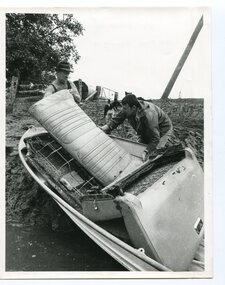
... Orbost...Snowy River...This series of photos documents some of the destruction from the January 1971 flood at Orbost. This flood was a record Snowy River flood and isolated the district through road and bridge destruction. ...These photos are significant because they document aspects of the record 1971 flood at Orbost, and are of good quality. Orbost Snowy River 1971 flood 2733.1 1971 FLOOD. 2733.2 1971 FLOOD. 2733.3 1971 FLOOD. 2733.4 FLOOD MARKER AT ORBOST BUTTER FACTORY. 2733.5 1971 FLOOD HIGHWAY AT SOUTHERN END OF TOWN. 2733.6 1971 FLOOD CLEANING UP. ...This series of photos documents some of the destruction from the January 1971 flood at Orbost. This flood was a record Snowy River flood and isolated the district through road and bridge destruction. These photos are significant because they document aspects of the record 1971 flood at Orbost, and are of good quality. A series of b/w photos from the 1971 record flood in Orbost. 2733.1 A b/w aerial photograph of a farm house with debris around, cattle in the background. Inscription: 1971 FLOOD. 2733.2 A b/w photo of 2 people walking towards an upturned vehicle in floodwaters. Inscription: 1971 FLOOD. 2733.3 A b/w photo taken at night time. Five people beside and climbing on a tree which has been uprooted, with water flowing underneath. Inscription: 1971 FLOOD. 2733.4 A b/w photo of a man standing in doorway of the old pumphouse for the Butter Factory. He is leaning out of the doorway and pointing to a mark on the wall (presumably the height of the 1971 flood). Inscription: FLOOD MARKER AT ORBOST BUTTER FACTORY. 2733.5 A b/w photo of a man and woman walking on a road towards a section of the road which has been broken-up by a flood waters. Inscription: 1971 FLOOD HIGHWAY AT SOUTHERN END OF TOWN. 2733.6 A b/w photo of two men with a boat hauled up on an eroded bank. They appear to be loading or unloading car seats. Inscription on back: 1971 FLOOD CLEANING UP. 2733.1 1971 FLOOD. 2733.2 1971 FLOOD. 2733.3 1971 FLOOD. 2733.4 FLOOD MARKER AT ORBOST BUTTER FACTORY. 2733.5 1971 FLOOD HIGHWAY AT SOUTHERN END OF TOWN. 2733.6 1971 FLOOD CLEANING UP. orbost, snowy river, 1971 flood -
 Orbost & District Historical Society
Photograph - 1971 flood, Orbost, The Herald, 8.2.1971
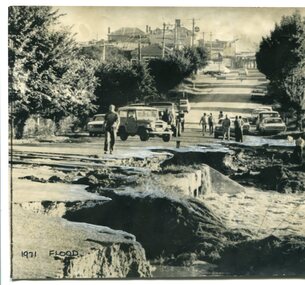
... Orbost...Snowy River...This is one of many photos taken following the devastating Snowy River flood of 1971 which inflicted huge impact on the Orbost area, including access roads to Orbost. ...Written on the back of the photo: 'Orbost and its 3,000 people in East Gippsland were cut off today by 50 square miles of Snowy River floodway. ...Orbost Snowy River 1971 flood damage Written in black ink below the photo: '1971 flood'. ...This is one of many photos taken following the devastating Snowy River flood of 1971 which inflicted huge impact on the Orbost area, including access roads to Orbost. This photo shows road damage at the southern end of Nicholson Street, adjacent to the Snowy River. This was the main road leading in to Orbost and also the Princes Highway in 1971. Orbost was completely cut off for several days following this flood. This photo is significant because it shows the impact of the 1971 Snowy River flood on the main road leading into Orbost. A b/w photo showing severe damage to a roadway in the foreground, people walking on the intact roadway behind, and the road leading up a hill through buildings. Written in black ink below the photo: '1971 flood'. Written on the back of the photo: 'Orbost and its 3,000 people in East Gippsland were cut off today by 50 square miles of Snowy River floodway. The washed out Princes Highway a quarter mile on the Melbourne side of Orbost in East Gippsland, today. ln the background is Orbost's main street'.orbost, snowy river, 1971 flood damage -
 Orbost & District Historical Society
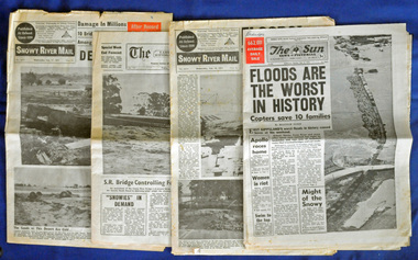
newspapers, February, March 1971
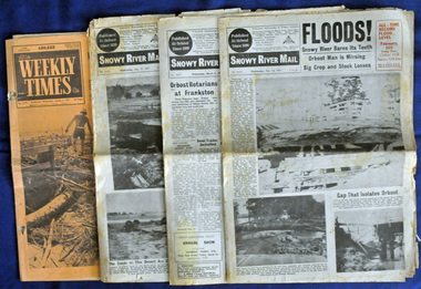
... floods-orbost-1971 snowy-river-mail weekly-times newspapers...They contain news articles and photographs of the floods in Orbost in early 1971. 2556.1 is the Weekly Times dated 3.3.1971 and has an orange cover. 2556.2 is a Snowy River Mail dated 17.2.1971. 2556.3 is a Snowy River Mail dated 10.2.1971. 2556.4 is a Snowy River Mail dated 3.3.1971....(see orbosthistory.com.au) These newspapers are contemporary records of a significant local event. floods-orbost-1971 snowy-river-mail weekly-times newspapers Four newspapers relating to the floods in 1971. ...The 1971 flood was the the worst flood on record. At Jarrahmond it was at least 11 metres and up to one and a half kilometres wide on the flats causing enormous damage to the flood plain. Records say that "The brown floodwater stain in Bass Strait could be seen from passing airliners." Considerable damage was done to railway infrastructure, roads and farms. More information from the APRIL, 2008 newsletter by John Phillips. (see orbosthistory.com.au) These newspapers are contemporary records of a significant local event.Four newspapers relating to the floods in 1971. They contain news articles and photographs of the floods in Orbost in early 1971. 2556.1 is the Weekly Times dated 3.3.1971 and has an orange cover. 2556.2 is a Snowy River Mail dated 17.2.1971. 2556.3 is a Snowy River Mail dated 10.2.1971. 2556.4 is a Snowy River Mail dated 3.3.1971.floods-orbost-1971 snowy-river-mail weekly-times newspapers -
 Orbost & District Historical Society
newspaper clippings, April, May 1987
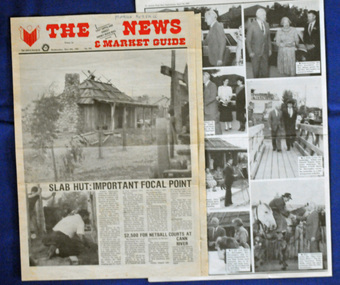
... Slab-Hut-Orbost newspaper-Snowy-River-Mail...Orbost Visitor Information Centre is situated in Forest Park on Nicholson Street. The centre is housed in the historic Slab Hut. The hut was an original family dwelling built in 1872, on a site approximately three kilometres upstream from the junction of the Buchan and Snowy Rivers. ...A selection of articles from The News and the Snowy River Mail. All relate to the opening of the Slab Hut, the Orbost Visitor Information Centre. ...Slab-Hut-Orbost newspaper-Snowy-River-Mail A selection of articles from The News and the Snowy River Mail. ...The Slab Hut (Orbost Visitor Information Centre) was opened on March 28, 1987. It was officially opened by Dr D. Caughey, the governor of Victoria. The Orbost Visitor Information Centre is situated in Forest Park on Nicholson Street. The centre is housed in the historic Slab Hut. The hut was an original family dwelling built in 1872, on a site approximately three kilometres upstream from the junction of the Buchan and Snowy Rivers. The Hut was removed from its original site around 1970, and stored until 1984 when the Shire Council approved the current site. It was restored and brought to life as a Tourist Information Centre in 1987.The Slab Hut is an icon of Orbost. These newspaper articles are contemporary records of the opening of this building.A selection of articles from The News and the Snowy River Mail. All relate to the opening of the Slab Hut, the Orbost Visitor Information Centre. They are photographs, information and the history of the Slab Hut.slab-hut-orbost newspaper-snowy-river-mail -
 Orbost & District Historical Society
newspaper, Snowy River Mail, 30.1.1991
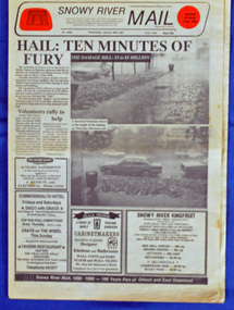
... hail-storm-orbost-1991 snowy river mail...A Snowy River Mail newspaper, dated 30.1.1991. the main article relates to the severe hail storm in Orbost on January 24, 1991. ...This newspaper records contemporary accounts of significant local events. hail-storm-orbost-1991 snowy river mail A Snowy River Mail newspaper, dated 30.1.1991. the main article relates to the severe hail storm in Orbost on January 24, 1991. ...On 24 January 1991 a severe hailstorm occurred in Orbost. The Insurance Council of Australia estimated the 1991 damage at $12 million. This newspaper records contemporary accounts of significant local events.A Snowy River Mail newspaper, dated 30.1.1991. the main article relates to the severe hail storm in Orbost on January 24, 1991. The newspaper contains news articles, photographs and advertisements.hail-storm-orbost-1991 snowy river mail -
 Orbost & District Historical Society
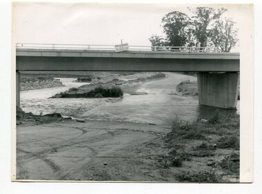
newspaper, Snowy River Mail, 1.12.1976
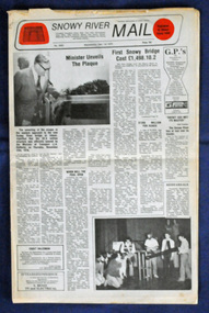
... Snowy-River-Bridge Orbost-bridges Snowy-River-Mail...Orbost bypass road design. This was a major project involving not only a new bridge over the Snowy River (including Lochiel Lagoon), but other bridges over Ashby’s Gulch and Watt’s Gulch. ...Snowy-River-Bridge Orbost-bridges Snowy-River-Mail A Snowy River Mail newspaper, dated 1.12.1976. ...In early 1974, as an Engineer with the Country Roads Board, David came to Orbost as the Supervising Engineer for the construction of the new bridges which were part of an 8.4km Orbost bypass road design. This was a major project involving not only a new bridge over the Snowy River (including Lochiel Lagoon), but other bridges over Ashby’s Gulch and Watt’s Gulch. These new bridges were opened in November 1976 with the unveiling of a plaque on the eastern end of the $2.4M Snowy River Bridge. The new bridge, built by the CRB at a cost of $2.4 million, is 1.6 metres above the record flood levels of 1971. (ref. May Leatch) This newspaper contains contemporary reports of a significant event in Orbost.A Snowy River Mail newspaper, dated 1.12.1976. It contains news articles, photographs and advertisements. The main article relates to the official opening of the Snowy River Bridge and the unveiling of a plaque on the eastern approach. It also contains a history of the first Snowy River Bridge.snowy-river-bridge orbost-bridges snowy-river-mail -
 Orbost & District Historical Society
Postcard - postcards of Orbost district, c. 1930s
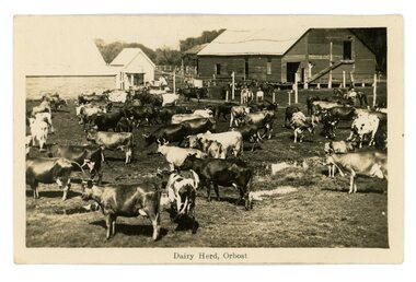
... Orbost...railway...Snowy River...These 4 postcards show various aspects of the Orbost district - dairying, railways, buildings, Snowy River...3345.1 Snowy River, Orbost 3345.2 Dairy Herd, Orbost 3345.3 Railway Viaduct, Orbost Flats 3345.4 G & N Stores, orbost ...These 4 postcards show various aspects of the Orbost district - dairying, railways, buildings, Snowy River These postcards are significant because they show aspects of the Orbost district, c.1920s-1940s Orbost railway Snowy River Gippsland & Northern dairying 3345.1 Snowy River, Orbost 3345.2 Dairy Herd, Orbost 3345.3 Railway Viaduct, Orbost Flats 3345.4 G & N Stores, orbost Four postcards, all b/w of Orbost scenes. 3345.1 shows a river in the foreground, farm house and buildings. 3345.2 farm buildings, barns, people and a dairy herd 3345.3 shows a long railway bridge across flat land, farm buildings 3345.4 shows a large building on the corner of two streets. ...These 4 postcards show various aspects of the Orbost district - dairying, railways, buildings, Snowy RiverThese postcards are significant because they show aspects of the Orbost district, c.1920s-1940sFour postcards, all b/w of Orbost scenes. 3345.1 shows a river in the foreground, farm house and buildings. 3345.2 farm buildings, barns, people and a dairy herd 3345.3 shows a long railway bridge across flat land, farm buildings 3345.4 shows a large building on the corner of two streets. 3345.1 Snowy River, Orbost 3345.2 Dairy Herd, Orbost 3345.3 Railway Viaduct, Orbost Flats 3345.4 G & N Stores, orbost orbost, railway, snowy river, gippsland & northern, dairying -
 Orbost & District Historical Society
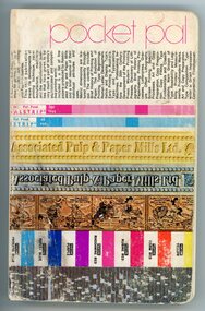
Book, Associated Pulp & Paper Mills Ltd, August 1973
... Orbost...printing...snowy river...This actual booklet was used by a compositor working at the 'Snowy River Mail' in Orbost. The 'S R Mail' did all types of printing, including the local newspaper. 196 pages....This item is significant because it was used by a local compositor working at the 'Snowy River Mail', Orbost, c. 1970s, 1980s. Orbost printing snowy river mail pocket pal Pocket pal Associated Pulp and Paper Mills Ltd A medium size book with a creamy pink background colour on the cover, overlaid with a multi-coloured graphics and photos in bands across the page. ...This booklet is a 'graphic arts digest' used in the printing industry. Used by commercial artists, in advertising, and by production managers, all of whom are concerned with the graphic arts. This actual booklet was used by a compositor working at the 'Snowy River Mail' in Orbost. The 'S R Mail' did all types of printing, including the local newspaper. 196 pages.This item is significant because it was used by a local compositor working at the 'Snowy River Mail', Orbost, c. 1970s, 1980s.A medium size book with a creamy pink background colour on the cover, overlaid with a multi-coloured graphics and photos in bands across the page. The words Pocket pal are at the top of the page.Pocket pal Associated Pulp and Paper Mills Ltdorbost, printing, snowy river mail, pocket pal -
 Orbost & District Historical Society
newspapers, February 1971
... floods-orbost-1971 newspaper snowy-river-mail sun-news-pictorial...They contain information and photographs pertaining to the 1971 floods in Orbost. 2557.1 is a Sun News Pictorial dated 8.2.1971. 2557.2 is a Snowy River Mail dated 10.2.1971. 2557.3 is an east Gippsland News dated 12.2.1971. 2557.4 is a Snowy River mail dated 12.2.1971 and 2557.5 is a collection of various clippings....Orbost were the worst on record. At Jarrahmond the river rose to a height of 11 metres and on the flats spread to one and a half kilometres wide. Considerable damage was done to railway infrastructure, roads and farms. More information from the APRIL, 2008 newsletter by John Phillips. (see orbosthistory.com.au) These newspapers are contemporary records of a significant local event. floods-orbost-1971 newspaper snowy ...The 1971 floods at Orbost were the worst on record. At Jarrahmond the river rose to a height of 11 metres and on the flats spread to one and a half kilometres wide. Considerable damage was done to railway infrastructure, roads and farms. More information from the APRIL, 2008 newsletter by John Phillips. (see orbosthistory.com.au)These newspapers are contemporary records of a significant local event.Four newspapers and a set of clippings from various papers. They contain information and photographs pertaining to the 1971 floods in Orbost. 2557.1 is a Sun News Pictorial dated 8.2.1971. 2557.2 is a Snowy River Mail dated 10.2.1971. 2557.3 is an east Gippsland News dated 12.2.1971. 2557.4 is a Snowy River mail dated 12.2.1971 and 2557.5 is a collection of various clippings.floods-orbost-1971 newspaper snowy-river-mail sun-news-pictorial -
 Orbost & District Historical Society
black and white photograph, Campbell. D.S, late 19th century ?
... Orbost-19th-century Snowy-River...This is a photograph of the settlement of Orbost on the banks of the Snowy River,. In the foreground in the paddock there is a water trough (Bills?) ...This is a pictorial record o The township of Orbost in the late 19th century. Orbost-19th-century Snowy-River on front - Orbost A black / white photograph / postcard. ...This is a photograph of the settlement of Orbost on the banks of the Snowy River,. In the foreground in the paddock there is a water trough (Bills?) and the B Drain can be seen on the far left. D.S. Campbell had a stationery store in Nicholson Street Orbost and published several black and white postcards of Orbost.This is a pictorial record o The township of Orbost in the late 19th century.A black / white photograph / postcard. There is a river in the foreground with houses and shops in the background behind a cleared paddock.on front - Orbostorbost-19th-century snowy-river -
 Orbost & District Historical Society
black and white photographs, October 22 1976
... Orbost-flood-1976 Snowy-River-Bridge Marlo-Road-flood-1976 Gilbert;s-Gulch-flood...Snowy River in two places. The road was closed when water flowed over Gilbert's Gulch (3243.1) The Snowy River broke its banks and flooded surrounding Orbost, Marlo, Lochend and Jarrahmond were isolated. ...Orbost-flood-1976 Snowy-River-Bridge Marlo-Road-flood-1976 Gilbert;s-Gulch-flood Nine black / white photographs of flood waters across roads. black and white photographs Snowy River Mail ...The road to Marlo was cut by flood waters from the Snowy River in two places. The road was closed when water flowed over Gilbert's Gulch (3243.1) The Snowy River broke its banks and flooded surrounding Orbost, Marlo, Lochend and Jarrahmond were isolated. The river bank at the bridge site was broken and filled with earth and rock fill. (3243.2) The new Snowy River Bridge was nearing completion when the river rose 7.2 metres causing erosion on the eastern bank. (3243.7) Contractors involved in the construction of the Princes Freeway and bridge were delayed by the flood waters. (3243.8) The 1976 flood at Orbost was a significant event which delayed the construction of the current Snowy River Road Bridge.These photographs record that event.Nine black / white photographs of flood waters across roads. orbost-flood-1976 snowy-river-bridge marlo-road-flood-1976 gilbert;s-gulch-flood -
 Orbost & District Historical Society
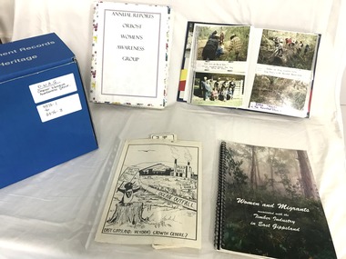
Archive - Orbost Womens Awareness Group collection
... orbost...pulp mill...snowy river...These items are albums, clippings, photos, documents, records, and digital media (CDs). 3376.1 Photo album 3376.2 Annual reports from 1990 - 2013 3376.3 Orbost Pulp Mill Proposal - information 3376.4 Newspaper clippings 1989-2025 3376.5 Newspaper clippings 2026-2015 3376.6 Snowy River Alliance 3376.7 History of the group 1989-2015 3376.8 Digitised items from OWAG 1989 onwards (Women and Migrants in the Timber Industry, 5 floppy discs; Flood Stories CD; Snowy River Rehabilitation CD; OWAG 20 years 2009 CD; OWAG tour Nov 2007 CD; 2 memory sticks) ...This small archive is a representation of a significant women's group which existed in Orbost from 1989 - 2015. orbost pulp mill snowy river Orbost womens awareness group Pulp Mill Womens Awareness Group OWAG is labelled on the box A box containing a number of items associated with the Pulp Mill Womens Awareness Group, and the Orbost Womens Awareness Group. ...The Pulp Mill Womens Awareness Group (PMWAG) began in 1989 in response to a proposal for a Pulp Mill in the Orbost District, East Gippsland, Victoria. After several years, with the Pulp Mill issue dying down, in 1993, the group decided to change its name to Orbost Womens Awareness Group (OWAG) and continued until finally disbanding in 2015. The group brought awareness to many community issues and proposals, as well as having a strong social aspect. This small archive is a representation of a significant women's group which existed in Orbost from 1989 - 2015. A box containing a number of items associated with the Pulp Mill Womens Awareness Group, and the Orbost Womens Awareness Group. These items are albums, clippings, photos, documents, records, and digital media (CDs). 3376.1 Photo album 3376.2 Annual reports from 1990 - 2013 3376.3 Orbost Pulp Mill Proposal - information 3376.4 Newspaper clippings 1989-2025 3376.5 Newspaper clippings 2026-2015 3376.6 Snowy River Alliance 3376.7 History of the group 1989-2015 3376.8 Digitised items from OWAG 1989 onwards (Women and Migrants in the Timber Industry, 5 floppy discs; Flood Stories CD; Snowy River Rehabilitation CD; OWAG 20 years 2009 CD; OWAG tour Nov 2007 CD; 2 memory sticks) OWAG is labelled on the boxorbost, pulp mill, snowy river, orbost womens awareness group, pulp mill womens awareness group