Showing 53 items matching "silk map"
-
 Bendigo Military Museum
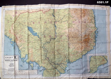
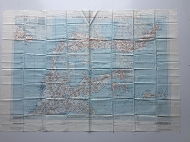
Photograph - Photograph of a silk map of Indo China, Circa 1939
... Photograph of a silk map of Indo China ...Photograph of a silk map of Indo China ...Silk maps were produced as "Escape Maps" as they were easily folded and compressed to carry. ....1P Photograph of a Silk map of Indo China Map No 44K covering Siam (Thailand) and part of Vietnam and Cambodia at a scale of 1:1million. ...Photograph of a silk map of Indo China Photograph Photograph of a silk map of Indo China ...Silk maps were produced as "Escape Maps" as they were easily folded and compressed to carry. They were often sewn into the jackets of aircraft pilots..1P Photograph of a Silk map of Indo China Map No 44K covering Siam (Thailand) and part of Vietnam and Cambodia at a scale of 1:1million. The map has contours (heights) and legend panel information. .2P Photograph of the reverse side of a Silk map of Indo China Map No 44J covering Siam (Thailand) at a scale of 1:1million. The map has contours (heights) and legend panel information. royal australian survey corps, rasvy, fortuna, army survey regiment, army svy regt -
 Geelong RSL Sub Branch
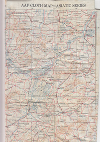
Silk Map - Asiatic Series, circa 1940s
... Silk Map - Asiatic Series......Silk Map...Silk Maps were produced by Great Britain and United States during WW2 some 3.5 million Silk Maps and cloth maps were produced for Allied Military Personnel....An oblong, cream colour silk map, Asiatic Series....Geelong RSL Sub Branch 50 Barwon Heads Road Belmont geelong-and-the-bellarine-peninsula Silk Maps were produced by Great Britain and United States during WW2 some 3.5 million Silk Maps and cloth maps were produced for Allied Military Personnel. ...Silk Maps were produced by Great Britain and United States during WW2 some 3.5 million Silk Maps and cloth maps were produced for Allied Military Personnel.This Silk Map is an original map from the WW2 era.An oblong, cream colour silk map, Asiatic Series.AAF Cloth Map-Asiatic Series Side 1 - No 34 Southeast China Side 2 - No35 - Northeast Chinaww2, silk map, great britain, united states -
 Nhill Aviation Heritage Centre
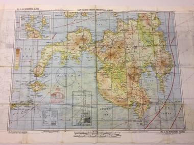
Map - Silk Map, No. 24 south celebes, c1942
... Silk Map......Silk...map...Silk maps produced by the USA for the Pacific war...White woven silk material with printed map and text North Celebes print on the reverse side South Celebes...Nhill Aviation Heritage Centre 1 Aerodrome Road Nhill grampians Silk maps produced by the USA for the Pacific war USA US Army Air Force Silk map Celebes SAAM No. 24 South Celebes White woven silk material with printed map and text North Celebes print on the reverse side South Celebes No. 24 south celebes Map Silk Map ...Silk maps produced by the USA for the Pacific warWhite woven silk material with printed map and text North Celebes print on the reverse side South CelebesNo. 24 South Celebesusa, us army air force, silk, map, celebes, saam, -
 B-24 Liberator Memorial Restoration Australia Inc
Map - Silk Map of South West Pacific Ocean, Ocen Currents and Surface winds of the West pacific Area May-October
... Silk Map of South West Pacific Ocean....Square silk map...REPRODUCED BY R.A.A.F HEADQUARTERS [cartographic section] OCTOBER 1944 RESTRICTED Square silk map Ocen Currents and Surface winds of the West pacific Area May-October Map Silk Map of South West Pacific Ocean. ...These maps were carried by air crew flying in the Pacific Ocean areas.Square silk mapOCEAN CURRENTS AND SURFACE WINDS FOR THE WEST PACIFIC AREA MAY- OCTOBER COMPILED BY THE 2ND AND 3RD OPERATIONS ANALYSIS SECTIONS,HQ, FEAF, FROM OCEAN CURRENT CHARTS DEIGNED BY THE SCRIPTS INSTITUTE OF OCEANOGRAPHY, AND FROM WIND CHARTS PREPARED BY THE U.S. WEATHER BUREAU. REPRODUCED BY R.A.A.F HEADQUARTERS [cartographic section] OCTOBER 1944 RESTRICTED -
 Bendigo Military Museum
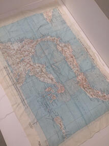
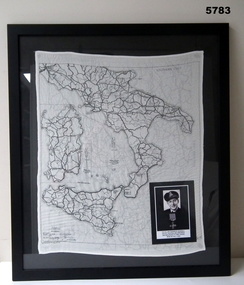
Map - MAP, ITALY, SILK, 1939 - 45
... MAP, ITALY, SILK...The silk maps were carried by Aircrew. This item carried by A.F. ...Framed silk map of Italy and Sicily, black frame with black backing, map is in all black, the other side shows Northern Italy, inset is a photo of A.F. ...Bendigo Military Museum 37 - 39 Pall Mall Bendigo goldfields The silk maps were carried by Aircrew. This item carried by A.F. ...The silk maps were carried by Aircrew. This item carried by A.F. Goodall DFC, RAAF, refer Cat No 543.2 for his service details.Framed silk map of Italy and Sicily, black frame with black backing, map is in all black, the other side shows Northern Italy, inset is a photo of A.F. Goodall DFC, RAAF.silk, maps -
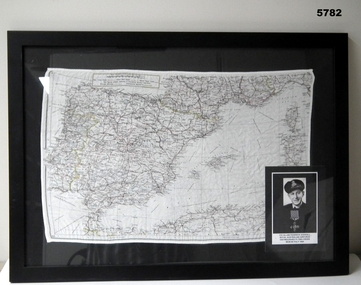 Bendigo Military Museum
Map - MAP, MEDITTERANEAN, SILK, C. 1939 - 45
... MAP, MEDITTERANEAN, SILK ...The silk maps were carried by Aircrew. Item in the collection re A.F. ...Framed black with black mounting background, silk map over in colour, scale 1: 3,000,000 showing the area of North Africa, Spain, France, Sardinia, the opposite side has mostly Southern France. ...Bendigo Military Museum 37 - 39 Pall Mall Bendigo goldfields The silk maps were carried by Aircrew. Item in the collection re A.F. ...The silk maps were carried by Aircrew. Item in the collection re A.F. Goodall DFC RAAF, refer Cat No 543.2 for his service details.Framed black with black mounting background, silk map over in colour, scale 1: 3,000,000 showing the area of North Africa, Spain, France, Sardinia, the opposite side has mostly Southern France. Inset over is a photo of A.F. Goodall.maps, silk -
 B-24 Liberator Memorial Restoration Australia Inc
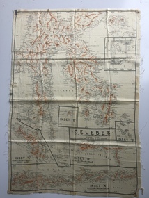
Map - Australian World War II silk map of Celebes, 1940s
... Australian World War II silk map of Celebes ...Silk and rayon maps were produced by Australia, Great Britain (some 1.75 million in total) and the United States (c.7.5 million) during World War II. ...They were issued to Allied military personnel as part of 'escape and evasion' kits. This silk map, one of relatively few produced in Australia (most Australian RAAF pilots and crew were issued with British and US maps), is an original map from World War II. world war ii silk maps australia a185 'Prepared under the direction of RAAF Headquarters' Celebes (with Insets 'A' to 'E') An oblong, cream colour, single-sided map printed in black and white with brown contours, Celebes Map Australian World War II silk map of Celebes ...Silk and rayon maps were produced by Australia, Great Britain (some 1.75 million in total) and the United States (c.7.5 million) during World War II. They were issued to Allied military personnel as part of 'escape and evasion' kits.This silk map, one of relatively few produced in Australia (most Australian RAAF pilots and crew were issued with British and US maps), is an original map from World War II.An oblong, cream colour, single-sided map printed in black and white with brown contours, Celebes 'Prepared under the direction of RAAF Headquarters' Celebes (with Insets 'A' to 'E')world war ii, silk maps, australia, a185 -
 B-24 Liberator Memorial Restoration Australia Inc
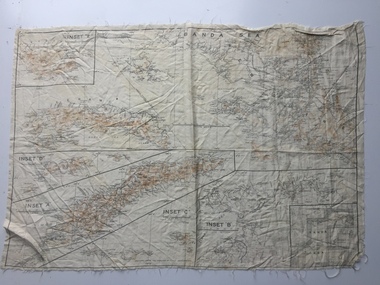
Map - Australian World War II silk map of Banda Sea, 1940s
... Australian World War II silk map of Banda Sea...Silk and rayon maps were produced by Australia, Great Britain (some 1.75 million in total) and the United States (c.7.5 million) during World War II. ...They were issued to Allied military personnel as part of 'escape and evasion' kits. This silk map, one of relatively few produced in Australia (most Australian RAAF pilots and crew were issued with British and US maps), is an original map from World War II. world war ii silk maps australia a186 Banda Sea (with Insets 'A' to 'E') An oblong, cream colour, single-sided map printed in black and white with brown contours, Banda Sea Map Australian World War II silk map of Banda Sea ...Silk and rayon maps were produced by Australia, Great Britain (some 1.75 million in total) and the United States (c.7.5 million) during World War II. They were issued to Allied military personnel as part of 'escape and evasion' kits.This silk map, one of relatively few produced in Australia (most Australian RAAF pilots and crew were issued with British and US maps), is an original map from World War II.An oblong, cream colour, single-sided map printed in black and white with brown contours, Banda Sea Banda Sea (with Insets 'A' to 'E')world war ii, silk maps, australia, a186 -
 B-24 Liberator Memorial Restoration Australia Inc
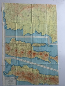
Map - British World War II silk map of Sumatra (South) and Java (Extreme North West), 1944
... British World War II silk map of Sumatra (South) and Java (Extreme North West)...Silk and rayon maps were produced by Great Britain (some 1.75 million in total), the United States (c.7.5 million) and Australia during World War II. ...This map, printed on rayon, is an original British 'escape and evasion' kit map from World War II. world war ii silk maps great britain a187 Sheet G Sumatra (South) and Java (Extreme North West) and, on the reverse, Sheet H Borneo (South West), Java and Sumatra (Extreme South) A multi-coloured, contoured, double-sided map printed on rayon, 1944 Series South West Pacific Area (SWPA) and Asia Map British World War II silk map of Sumatra (South) and Java (Extreme North West) ...Silk and rayon maps were produced by Great Britain (some 1.75 million in total), the United States (c.7.5 million) and Australia during World War II. They were issued to Allied military personnel as part of 'escape and evasion' kits.This map, printed on rayon, is an original British 'escape and evasion' kit map from World War II.A multi-coloured, contoured, double-sided map printed on rayon, 1944 Series South West Pacific Area (SWPA) and Asia Sheet G Sumatra (South) and Java (Extreme North West) and, on the reverse, Sheet H Borneo (South West), Java and Sumatra (Extreme South)world war ii, silk maps, great britain, a187 -
Moorabbin Air Museum
Map (item) - Silk Map Holland Belgium France Germany Switzerland Sheet C and D
... Silk Map Holland Belgium France Germany Switzerland Sheet C and D...Moorabbin Air Museum Moorabbin Airport 12 First Street Moorabbin melbourne Map Silk Map Holland Belgium France Germany Switzerland Sheet C and D ... -
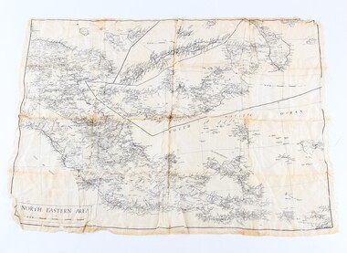 Shepparton RSL Sub Branch
Silk escape map
... Silk escape map...Silk escape map of Northeastern Area of Papua and New Britain. ...SCALE 94 mm to 50 miles. Silk escape map ...Used by Allied troops in the Pacific in ww2Silk escape map of Northeastern Area of Papua and New Britain. Black printing on white silk. SCALE 94 mm to 50 miles.Northeastern Area escape map -
 B-24 Liberator Memorial Restoration Australia Inc
Map - Silk Escape Map, NO. C45 EAST BORNEO
... Silk Escape Map ...C45 EAST BORNEO Map Silk Escape Map ...These maps were used by Air crew in case of air craft crashing.Fabric map of East Borneo.AAF CLOTH CHART NO. C-45 EAST BORNEO (Other side Chart No. C-46) No.C-45 EAST BORNEO S120-E11340/540Nx520 -
 Shepparton RSL Sub Branch
Escape Map Cloth, July 1944
... ...silk escape map...Silk escape map issued to Allied Airmen during World War 11 for the Pacific campaigns...Shepparton RSL Sub Branch 88 Wyndham Street Shepparton the-murray Silk escape map issued to Allied Airmen during World War 11 for the Pacific campaigns A silk escape map including detail of tides and winds was relevant to air force personnel in Pacific regions during WW2. world war ii second world war silk escape map pacific conflict AAF Cloth Cart- Philippine Series Prepared under the direction of the Commanding General, Army Air Forces, by the aeronautical Chart Service, Washington DC July 1944 Coloured Cloth Escape Map of Side A : No. ...Silk escape map issued to Allied Airmen during World War 11 for the Pacific campaignsA silk escape map including detail of tides and winds was relevant to air force personnel in Pacific regions during WW2. Coloured Cloth Escape Map of Side A : No. C44 North Borneo Side B: No C43 Mindanao Island SCALE: 1:1,000,000; Wind and Current markings; AAF Cloth Cart- Philippine Series Prepared under the direction of the Commanding General, Army Air Forces, by the aeronautical Chart Service, Washington DC July 1944world war ii, second world war, silk escape map, pacific conflict -
 Dandenong/Cranbourne RSL Sub Branch
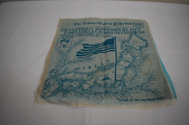
Memorabilia - Instrument of Surrender
... Silk map of Japan...Dandenong/Cranbourne RSL Sub Branch 44 – 50 Clow Street Dandenong melbourne Unconditional surrender of Japan. Silk map of Japan Memorabilia Instrument of Surrender. ...Unconditional surrender of Japan. -
Running Rabbits Military Museum operated by the Upwey Belgrave RSL Sub Branch
Pilot's Map
... Silk map of Celbres Island Indonesia...Running Rabbits Military Museum operated by the Upwey Belgrave RSL Sub Branch 1 Mast Gully Road Upwey melbourne Part of Survival Pack Equipment WW2 RAAF Silk map of Celbres Island Indonesia Pilot's Map ...Part of Survival PackSilk map of Celbres Island Indonesiaequipment, ww2, raaf -
Moorabbin Air Museum
Equipment (Item) - J B Ryan Collection Navigator's Equipment and Survival Kit see Description for details
... Slide Rule Navigation Computer Foldable ruler Silk Maps Directories of Airports in Australia and Southwest Pacific Correspondence and photos Compass Bi Focal Lense Mini telescope Heliograph Whistle ...Moorabbin Air Museum Moorabbin Airport 12 First Street Moorabbin melbourne Slide Rule Navigation Computer Foldable ruler Silk Maps Directories of Airports in Australia and Southwest Pacific Correspondence and photos Compass Bi Focal Lense Mini telescope Heliograph Whistle Equipment J B Ryan Collection Navigator's Equipment and Survival Kit see Description for details ... -
Moorabbin Air Museum
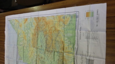
Map - South East Pacific Silk Maps
... Description: 4 Silk Survival Maps RAAF Issue (envelope) Survival Kit Documentation (envelope) AAP Date: Author: RAAF Amended to AL Publisher: RAAF Pages: Binding: Content/Keywords:. ...Level of Importance: Map South East Pacific Silk Maps ...Historical Details: . Description: 4 Silk Survival Maps RAAF Issue (envelope) Survival Kit Documentation (envelope) AAP Date: Author: RAAF Amended to AL Publisher: RAAF Pages: Binding: Content/Keywords:. Level of Importance: -
 Bendigo Military Museum
Map - SILK MAPS, LAND HQ CARTOGRAPHIC COY, 1939-1945
... 1. & 2. White silk maps, printing in black ink. Topographer information, roads and rivers shown. ...Words are in English. Map SILK MAPS LAND HQ CARTOGRAPHIC COY. ...The soldier who had these was; "Gilbert Kerr MacKenzie", N247489 (born Sydney, enlisted Marrackville) on 6 Nov 1941, Age 18 years, 9 mths. Transferred to 2nd AIF 12 Nov 1942 as number NX132907. Promoted in the field to Lieut, 4 Feb 1945. Posted to “Z” Special Unit. Discharged 14 Aug 1946. Last Rank Lieut in WW2. Later Colonel when retired. Last Unit - “Z” Special Unit.1. & 2. White silk maps, printing in black ink. Topographer information, roads and rivers shown. It aso shows place names and border lines, i.e. British North Borneo, China Sea, Dutch Borneo. It covers 109.5 to 116 degrees East and 0.5 to 116 degrees North Lat. On the maps are printed Divisional areas - 1st to 5th Division. The maps are not hemmed. Words are in English.ww2, silk maps, pacific war, z special unit, gilbert kerr mackenzie -
 Clayton RSL Sub Branch
Memorabilia - Silk Escape Scarf, WW2
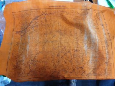
... orange silk scarf with map of burma on one side and a map of north burma on the other side....World War Two Second World War WW2 WWII scarf Burma escape scarf One side - Central Burma Second side - North Burma orange silk scarf with map of burma on one side and a map of north burma on the other side. ...Escape scarf was issued to all military personnel, both army and airforce and personnel in theatres of war. The scarf was designed to provide information on escape routes if the soldier/pilot was captured. The scarf was donated to the RSL by Cedric Hamilton Chindit WW2.Unusual orange silk escape scarf with Burma and North Burma map. Colour may indicate that the scarf was primarily to be used for nighttime viewing.orange silk scarf with map of burma on one side and a map of north burma on the other side.One side - Central Burma Second side - North Burmaworld war two, second world war, ww2, wwii, scarf, burma, escape scarf -
 B-24 Liberator Memorial Restoration Australia Inc
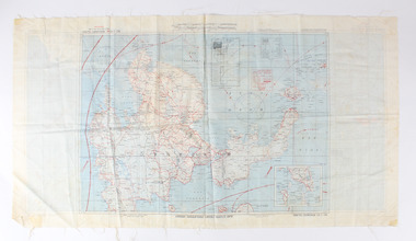
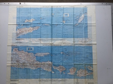
Map - US World War II-coloured map, - Southwest Pacific Area, No.22 Southwestern, No.26 East Java, No.25 Timor, 1943
... Silk and rayon maps were produced by the United States (c. 7.5 million in total), Great Britain (some 1.75 million in total) and Australia during World War II. ...B-24 Liberator Memorial Restoration Australia Inc Corner Farm Rd & Princes Highway Werribee melbourne Silk and rayon maps were produced by the United States (c. 7.5 million in total), Great Britain (some 1.75 million in total) and Australia during World War II. ...Silk and rayon maps were produced by the United States (c. 7.5 million in total), Great Britain (some 1.75 million in total) and Australia during World War II. They were issued to Allied military personnel as part of 'escape and evasion' kits.This map, printed on acetate rayon, is an original US 'escape and evasion' kit map from World War II.A multi-coloured, contoured, double-sided map printed on acetate rayon AAF Cloth Map - Southwest Pacific Area Side 1 - No. 22 Southwestern and No. 26 East Java Side 2 - No. 25 Timorworld war ii, silk maps, united states of america, a188 -
 B-24 Liberator Memorial Restoration Australia Inc
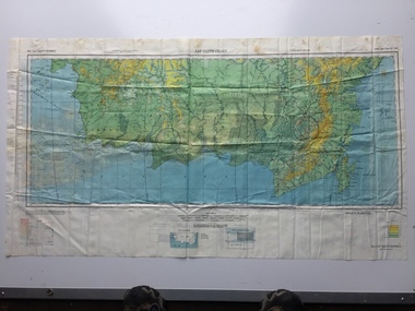
Map - US World War II multi-coloured map - Philippine Series, No. C-43 Mindanao Series, No. C-44 North Borneo, 1944
... Silk and rayon maps were produced by the United States (c. 7.5 million in total), Great Britain (some 1.75 million in total) and Australia during World War II. ...This map, printed on acetate rayon, is an original US 'escape and evasion' kit map from World War II. united states of america silk and rayon maps world war ii AAF Cloth Chart - Philippine Series Side 1 - No. ...Silk and rayon maps were produced by the United States (c. 7.5 million in total), Great Britain (some 1.75 million in total) and Australia during World War II. They were issued to Allied military personnel as part of 'escape and evasion' kits.This map, printed on acetate rayon, is an original US 'escape and evasion' kit map from World War II.A multi-coloured, contoured, double-sided map printed on acetate rayon AAF Cloth Chart - Philippine Series Side 1 - No. C-43 Mindanao Series Side 2 - No. C.44 North Borneounited states of america, silk and rayon maps, world war ii -
 B-24 Liberator Memorial Restoration Australia Inc
Map - US World War II multi-coloured map, Side 1 - No. C-47 South Borneo, Side 2 - No. C-48 West Java, 1944
... Silk and rayon maps were produced by the United States (c. 7.5 million in total), Great Britain (some 1.75 million in total) and Australia during World War II. ...This map, printed on acetate rayon, is an original US 'escape and evasion' kit map from World War II. united states of america silk and rayon maps world war ii a191 AAF Cloth Chart Side 1 - No. ...Silk and rayon maps were produced by the United States (c. 7.5 million in total), Great Britain (some 1.75 million in total) and Australia during World War II. They were issued to Allied military personnel as part of 'escape and evasion' kits.This map, printed on acetate rayon, is an original US 'escape and evasion' kit map from World War II.A multi-coloured, contoured, double-sided map printed on acetate rayon AAF Cloth Chart Side 1 - No. C-47 South Borneo Side 2 - No. C.48 West Javaunited states of america, silk and rayon maps, world war ii, a191 -
 B-24 Liberator Memorial Restoration Australia Inc
Map - US World War II multi-coloured map- Southwest Pacific Area, No. 23 North Celebes, No. 24 South Celebes, 1942-1943
... Silk and rayon maps were produced by the United States (c. 7.5 million in total), Great Britain (some 1.75 million in total) and Australia during World War II. ...B-24 Liberator Memorial Restoration Australia Inc Corner Farm Rd & Princes Highway Werribee melbourne Silk and rayon maps were produced by the United States (c. 7.5 million in total), Great Britain (some 1.75 million in total) and Australia during World War II. ...Silk and rayon maps were produced by the United States (c. 7.5 million in total), Great Britain (some 1.75 million in total) and Australia during World War II. They were issued to Allied military personnel as part of 'escape and evasion' kits.This map, printed on acetate rayon, is an original US 'escape and evasion' kit map from World War II.A multi-coloured, contoured, double-sided map printed on acetate rayon AAF Cloth Map - Southwest Pacific Area Side 1 - No. 23 North Celebes Side 2 - No. 24 South Celebesworld war ii, silk maps, united states of america, a189 -
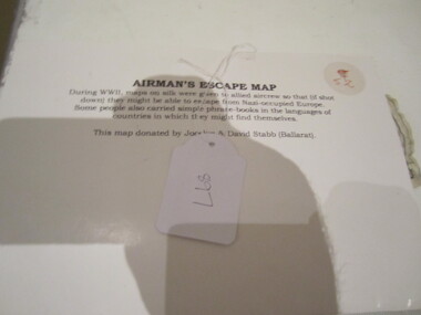 Ballarat RSL Sub-Branch Inc.
Cloth Map - Airman's Escape Map France, Belgium & Holland
... During WWII, maps on silk were given to allied aircrew so that (if shot down) they might be able to escape from Nazi-occupied Europe. ...Ballarat RSL Sub-Branch Inc. 330 Heinz Lane Invermay Park goldfields During WWII, maps on silk were given to allied aircrew so that (if shot down) they might be able to escape from Nazi-occupied Europe. ...During WWII, maps on silk were given to allied aircrew so that (if shot down) they might be able to escape from Nazi-occupied Europe. Some people also carried simple phrase books in the languages of countries in which they might find themaps, ballarat rsl, ballarat -
Lara RSL Sub Branch
Silk Maps, Four Collective maps
... Map 1....Silk Fabric ... "Western Pacific.Map 2....Silk fabric....Hong Kong /Canton.Map 3Cloth Map East Java South West Pacific.Map 4....Arakan/Irrawaddy fabric map.M...Map 4....Restricted..Edition 1 -gsgsFabric Map 1;1,000,000 Map 3....No 25 Timor/No 26 East Java .Map 2 Hong Kong/Canton restricted MAP 1,NACI - HO. No.S 12. Map 1....Silk Fabric ... "Western Pacific.Map 2....Silk fabric....Hong Kong /Canton.Map 3Cloth Map East Java South West Pacific.Map 4....Arakan/Irrawaddy fabric map.M Four Collective maps Silk Maps ...Scientific or research signifigance.Map 1....Silk Fabric ... "Western Pacific.Map 2....Silk fabric....Hong Kong /Canton.Map 3Cloth Map East Java South West Pacific.Map 4....Arakan/Irrawaddy fabric map.MMap 4....Restricted..Edition 1 -gsgsFabric Map 1;1,000,000 Map 3....No 25 Timor/No 26 East Java .Map 2 Hong Kong/Canton restricted MAP 1,NACI - HO. No.S 12. -
 Warrnambool and District Historical Society Inc.
Book - Family Bible, John Murphy Company, The Holy Bible Douay Version, 1899
... maps. Amongst the pages are two pressed pansies and two loose sheets. .2 This is a brown tooled leather cover for the Bible with a brown silk lining and a brown cord attached to the top of the spine for use as a bookmark. ...maps. Amongst the pages are two pressed pansies and two loose sheets. .2 This is a brown tooled leather cover for the Bible with a brown silk lining and a brown cord attached to the top of the spine for use as a bookmark. ...This Bible and cover belonged to Ethel Ardlie, nee Ryan (1880-1967). In 1903 she married Arthur Stanley Ardlie of Warrnambool. Arthur Ardlie was the son of the prominent Warrnambool lawyer, William Ardlie and his wife Mary and the grandson of John and Mary Ardlie, pioneer settlers in Warrnambool. Ethel and Arthur Ardlie had three daughters, Olive (1905-1912), Dorothy (1910-1993) and Agnes (1915-1993). They lived at Aroona, Princess Street, Warrnambool.These items are of great interest firstly because they are examples of the type of Bible and cover that families owned in the mid 20th century. Also they are mementoes of a prominent family in Warrnambool in the 20th century, with the Bible containing important information on this family. .1 This is a Bible with a black cover with gold lettering on the spine. The cover is stained. The pages contain the Old Testament (1086 pages), a Family Register section, the New Testament (306 pages) and some coloured maps. Amongst the pages are two pressed pansies and two loose sheets. .2 This is a brown tooled leather cover for the Bible with a brown silk lining and a brown cord attached to the top of the spine for use as a bookmark. The front cover has an embossed image of seven figures. The edges of the spine of the cover are torn. Ethel M. Ardlie (x2) Aroona, Warrnambool ardlie family, history of warrnambool -
 Bendigo Military Museum
Photograph - A Section, 1st Topographic Survey Troop, Vung Tau, Vietnam, 1966
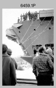
... A Section’s main tasks were to establish a Theatre Grid, map compilation and map revision; Engineer Survey Support in the camp and to the civil community; give assistance to the Cordon Search Missions by producing large scale plots from aerial photos with every house and fence etc plotted; and then reproduce these by silk screening usually, within a 24-hour period. ...A Section’s main tasks were to establish a Theatre Grid, map compilation and map revision; Engineer Survey Support in the camp and to the civil community; give assistance to the Cordon Search Missions by producing large scale plots from aerial photos with every house and fence etc plotted; and then reproduce these by silk screening usually, within a 24-hour period. ...This is a set of 12 photographs of A Section, 1st Topographic Survey Troop taken from the 25th of May to the 12th of June 1966 during their deployment to Vung Tau, Vietnam. Led by OC CAPT Bob Skitch, the ten personnel from A Section 1st Topo Svy Tp and six personnel from supporting units were the first contingent from the Royal Australian Survey Corps deployed to provide topographic support to the Australian Task Force in Vietnam. They arrived in Saigon, Vietnam on the 10th of June 1966 enroute to the Australian Reinforcement Unit (ARU) “back beach” camp in Vung Tau. The ten RA Svy technical personnel from 1st Topo Svy Tp deployed were: WO2 David Christie, SGT Stan Campbell, SGT Dave King, CPL Jim Roberts, CPL Dennis Duquemin, CPL Des Ceruti, SPR Derek Chambers, SPR Brian Firns, SPR Joe O’Connor and SPR Ron Smith. External personnel deployed were: WO2 Snow Rollston from Northern Command Field Survey Unit, T/CPL Peter Clarke – orderly room corporal, T/CPL Alan Carew – Technical Storeman, SPR Stan Johns – Map Storeman, SPR Boots Campbell – batman/driver and PTE BNF Brunning – cook. The ship featured in photos .1P and .2P was the aircraft carrier HMAS Sydney on its 4th voyage to Vietnam. On board were SGT Stan Campbell and SPR Brian Firns, tasked to manage A Section’s stores and equipment. The rest of A Section deployed to Vietnam by air on the chartered Qantas 707B ‘City of Longreach'. A Section’s main tasks were to establish a Theatre Grid, map compilation and map revision; Engineer Survey Support in the camp and to the civil community; give assistance to the Cordon Search Missions by producing large scale plots from aerial photos with every house and fence etc plotted; and then reproduce these by silk screening usually, within a 24-hour period. RA Svy’s support concluded with the withdrawal of Australian troops from Vietnam in 1972. More information on the A Section, 1st Topographic Survey Troop and the Army Survey Regiment’s supporting role is provided in pages 89 to 94 of Valerie Lovejoy’s book 'Mapmakers of Fortuna – A history of the Army Survey Regiment’ ISBN: 0-646-42120-4.This is a set of 12 photographs of A Section, 1st Topographic Survey Troop (1st Topo Svy Tp), taken from the 25th of May to the 12th of June 1966 during their deployment to Vung Tau, Vietnam. The black and white photographs were printed on photographic paper and are part of the Army Survey Regiment’s Collection. The photographs were scanned at 300 dpi. .1) &.2) - Photo, black & white, 1966. HMAS Sydney departing Woolloomooloo wharf en-route to Vietnam. .3) - Photo, black & white, 1966. A Section 1 Topo Svy Tp relaxing in a bar before deployment. OC CAPT Bob Skitch in centre of photo. .4) - Photo, black & white, 1966. Unidentified A Section 1 Topo Svy Tp personnel and troops from other units relaxing in a bar before deployment. .5) - Photo, black & white, 1966. A Section 1 Topo Svy Tp personnel arrival by bus at Saigon (Tan Son Nhut) Airport. OC CAPT Bob Skitch 4th from right. .6) - Photo, black & white, 1966. A Section 1 Topo Svy Tp personnel boarding the USAF Hercules aircraft enroute from Saigon (Tan Son Nhut) Airport to Vung Tau Airfield. OC CAPT Bob Skitch on left. .7) - Photo, black & white, 1966. A Section 1 Topo Svy Tp personnel and troops from other units boarding the USAF Hercules aircraft enroute from Saigon (Tan Son Nhut) Airport to Vung Tau Airfield. .8) & .9) - Photo, black & white, 1966. A Section 1 Topo Svy Tp personnel arrive at the Australian Reinforcement Unit (ARU) “back beach” camp. .10) - Photo, black & white, 1966. A Section 1 Topo Svy Tp personnel in oppressive conditions work on map products. .11) - Photo, black & white, 1966. Group photo of A Section 1 Topo Svy Tp. OC CAPT Bob Skitch on far right. .12) - Photo, black & white, 1966. Group photo of A Section 1 Topo Svy Tp. OC CAPT Bob Skitch 3rd from right.Annotated with the photo set - ‘ DET 1 Topo Svy Tp Vung Tau 25 May to 12 of Jun 66’royal australian survey corps, rasvy, army survey regiment, army svy regt, fortuna, asr, 1st topographical survey troop -
 Bendigo Military Museum
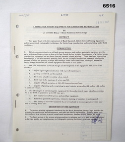
Administrative record - Royal Australian Survey Corps - A simple silk screen equipment for limited map reproduction by LTCOL HM Hall (RASvy) 1967, LtCol HM Hall (RASvy), 6 Feb 1967
... Royal Australian Survey Corps - A simple silk screen equipment for limited map reproduction by LTCOL HM Hall (RASvy) 1967...Royal Australian Survey Corps - A simple silk screen equipment for limited map reproduction by LTCOL HM Hall (RASvy) 1967...Written by LtCol HM Hall (RASvy) Royal Australian Survey Corps RASvy Fortuna Army Survey Regiment Army Svy Regt ASR School of Military Survey SMS 8 x A4 page document containing typed text, photos and map extract Royal Australian Survey Corps - A simple silk screen equipment for limited map reproduction by LTCOL HM Hall (RASvy) 1967 Administrative record Royal Australian Survey Corps - A simple silk screen equipment for limited map reproduction by LTCOL HM Hall (RASvy) 1967 LtCol HM Hall (RASvy) ...This paper deals with the employment of Hand operated Mobile Screen Printing Equipment and its associated cartographic techniques for limited map reproduction and overprinting under field conditions. Written by LtCol HM Hall (RASvy)8 x A4 page document containing typed text, photos and map extractroyal australian survey corps, rasvy, fortuna, army survey regiment, army svy regt, asr, school of military survey, sms -
 Bendigo Military Museum
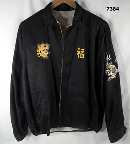
Souvenir - JACKET, Handmade in Vietnam, c1969
... silk fabric lining. With collar, long sleeves, cuffs with black plastic buttons, inset pockets and elasticised area on waist band. Front zipper closure. Handstitched decoration on front, top of sleeves and back of jacket. Front - left side, yellow cotton? Vietnamese writing, Right side - yellow, orange, white and brown cotton - face of a tiger. Top of sleeves - left and right - orange and white cotton - dragons. Back of jacket - blue, orange, green and yellow map...On map - yellow cotton "CAMBODIA/SAIGON" Jacket - bespoke handmade, in black cotton fabric exterior and white silk fabric lining. ...Item in a collection relating to Wes Bertuch, refer Cat No 1664.2 Jacket - bespoke handmade, in black cotton fabric exterior and white silk fabric lining. With collar, long sleeves, cuffs with black plastic buttons, inset pockets and elasticised area on waist band. Front zipper closure. Handstitched decoration on front, top of sleeves and back of jacket. Front - left side, yellow cotton? Vietnamese writing, Right side - yellow, orange, white and brown cotton - face of a tiger. Top of sleeves - left and right - orange and white cotton - dragons. Back of jacket - blue, orange, green and yellow map of Vietnam, Laos and Cambodia.On Jacket back - handstitched in yellow cotton "WHEN I DIE I'LL GO TO HEAVEN/ BECAUSE/ I'VE SPENT MY TIME IN HELL/ VIET & NAM/ 68 69". On and beside map - hand stitched in white cotton "LOVIS/ HANOI/ THAILAND HUE/ DA-NANG/ QLV-NI-ION/ BANGKOK NHA- TRANG/CAM-RANH/PHAN THIET/ BIEN HOA/ . On map - yellow cotton "CAMBODIA/SAIGON"souvenir, vietnam, clothing -
 Bendigo Military Museum
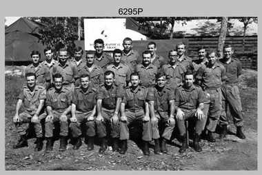
Photograph - A Section, 1st Topographic Survey Troop, Nui Dat, Vietnam, 1969
... map revision. Engineer Survey Support in the camp and to the civil community and give assistance to the Cordon Search Missions by producing large scale plots from aerial photos with every house and fence etc plotted and then reproduce these by silk screening usually, within a 24-hour period. ...map revision. Engineer Survey Support in the camp and to the civil community and give assistance to the Cordon Search Missions by producing large scale plots from aerial photos with every house and fence etc plotted and then reproduce these by silk screening usually, within a 24-hour period. ...This is a photograph of A Section, 1st Topographic Survey Troop taken at Nui Dat, Vietnam in 1969. A nominal roll of personnel and their trade as of the 30th of September 1969, accompanies this photo. Their trades in this photo were as follows - Surveyors Topographic: WO1 Darby Munro, SGT Paddy Strunks, SGT Graeme Birrell, CPL Brian Knight, CPL Colin Laybutt, SPR Roderick Gilbert and SPR Rodney Offer. Draughtsmen Topographic: SGT Terrance Linz, CPL Robert Kay, SPR Peter Aukstinaitis, SPR Lloyd Patterson and SPR Ian Wark. Photographer Cartographic: CPL George Graham. Clerk Admin: CPL Oreste Biziak. Helioworker: CPL Geoffrey White, SPR Lance Percey. Cook AACC: PTE R. Johnston. The first Royal Australian Survey Corps troops arrived in South Vietnam on the 10th of June 1966. This was a detachment from 1st Topographic Survey Troop, which was to give cartographic support to the Australian Task Force. Their main tasks were to establish a Theatre Grid, map compilation and map revision. Engineer Survey Support in the camp and to the civil community and give assistance to the Cordon Search Missions by producing large scale plots from aerial photos with every house and fence etc plotted and then reproduce these by silk screening usually, within a 24-hour period. This support concluded with the withdrawal of Australian troops from Vietnam in 1972. For more information on the career of A Section’s OC MAJ Peter Constantine AM, refer to item 6159P or 6092P. He was the CO of the Army Survey Regiment from 1975 to 1976 and CO of the School of Military Survey (SMS) from 1976 to his retirement in January 1982. His memoirs of active duty in Vietnam ‘Surveyor - Printer Behind the Lines’ was published in 2022. 2IC CAPT Frank Thorogood SB St J’s career culminated at the rank of LTCOL as the CO Army Survey Regiment from 1980 to 1981. More information on the A Section, 1st Topographic Survey Troop and the Army Survey Regiment’s supporting role is provided in pages 89 to 94 of Valerie Lovejoy’s book 'Mapmakers of Fortuna – A history of the Army Survey Regiment’ ISBN: 0-646-42120-4.This is a photograph of A Section, 1st Topographic Survey Troop taken at Nui Dat, Vietnam in 1969. The black and white photograph was printed on photographic paper and is part of the Army Survey Regiment’s Collection. The photograph was scanned at 300 dpi. .1) - Photo, black & white, 1969. Back row L to R: SPR Lance Percey, SPR Bruce Grisdale, SPR Rodney Offer, SPR Roderick Gilbert, CPL Geoffrey White, PTE R. Johnston, CPL Colin Laybutt, SPR Lloyd Patterson. Centre row L to R: SPR Peter Aukstinaitis, SPR Ian Hanna, SPR Ian Wark, CPL Robert Kay, CPL George Graham, CPL Oreste Biziak, CPL Brian Knight. Front row L to R: SGT Terrance Linz, SSGT Gordon Haswell, 2IC CAPT Frank Thorogood SB St J, OC MAJ Peter Constantine AM, WO1 Darby Munro, SGT Paddy Strunks, SGT Graeme Birrell.An A4 nominal roll of personnel and their trade accompanies the photo, as of the 30th of September 1969. A torn paper identifies the personnel in the photo. Annotated on back of photo – ‘Unit Photo – 1 Topo Svy Tp 30 Sept 69’royal australian survey corps, rasvy, army survey regiment, army svy regt, fortuna, asr