Showing 100 items matching "victorian harbours"
-
 Flagstaff Hill Maritime Museum and Village
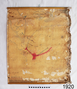
Document - Plan, Victorian Harbours Warrnambool, Victorian Harbours, Warrnambool, Plan to Accompany Sir John Coode's Report, 28-02-1879
... Victorian Harbours, Warrnambool, Plan to Accompany Sir John Coode's Report......victorian harbours...He was brought to Melbourne by the Melbourne Harbour Trust to advise on works to improve the Port of Melbourne. The Victorian Government commissioned him to present a plan to complete the Warrnambool Breakwater. ...Stamped "VICTORIAN HARBOURS / WARRNAMBOOL / PLAN / to accompany / SIR JOHN GOODE'S REPORT / DATED 28 FEB 1879" Signature "John Coode"...Victorian Harbours Warrnambool...Signed by Sir John Coode. Victorian Harbours, Warrnambool, Plan to Accompany Sir John Coode's Report Document Plan Australia Victoria Warrnambool Victorian Harbours Warrnambool ...This plan is of great significance to the local history of Warrnambool, in particular the Breakwater and its impact on Warrnambool's maritime and trade history. The plan shows the existing jetties at the Port of Warrnambool, plus the partially erected Breakwater and proposed works to the Breakwater by both the Borough of Warrnambool Surveyor and Sir John Coode. The plan was signed 28th February 1879 by Sir John Coode. The legend at the bottom left describes the existing works and the proposed works. The Warrnambool Breakwater Sir John Coode was a British harbour engineer. He was brought to Melbourne by the Melbourne Harbour Trust to advise on works to improve the Port of Melbourne. The Victorian Government commissioned him to present a plan to complete the Warrnambool Breakwater. His original plan was too expensive so he prepared a revised plan for a shorter structure. The work was completed in 1890. The construction proved to be too short to protect adequately from the weather and didn't allow enough depth for larger vessels to come into port. The decreasing trade was further affected by siltation in the bay due to the breakwater, and the completion of the railway line. The situation of the harbour became a real problem that, by 1910, required continuous dredging. In 1914 the Breakwater was extended but proved to be a failure because the work began to subside and by 1920 about two thirds of the harbour was silted up. Alterations made in the 1920's increased the silting problem and by the 1940's the harbour was no longer used. More alterations were made in the 1950's and 1960's. The Warrnambool Breakwater is registered as a place of significance on the Victorian Heritage Database. This plan of the proposed works for the existing Warrnambool Breakwater is of great significance to the local history of Warrnambool, in particular the Breakwater and its impact on Warrnambool's maritime and trade history. The Warrnambool Breakwater is registered as a place of significance on the Victorian Heritage Database (VHR H2024). It is historically significant to Victoria as one of the most important maritime engineering projects in Victoria in the late 19th century. The Warrnambool Breakwater is of historical significance as one of the most important maritime engineering projects in Victoria in the late nineteenth century. It is evidence of Victoria's nineteenth century investment in regional port infrastructure and the development of Victorian coastal shipping. It is of significance for its association with the English civil engineer Sir John Coode, the most distinguished harbour engineer of the nineteenth century, who was brought to Victoria to advise on works to improve the Port of Melbourne, but was retained by the Government to advise on improvements to the harbours at Portland, Geelong, Port Fairy, and Lakes Entrance, as well as Warrnambool. His projects for Melbourne, Lakes Entrance and Warrnambool were major engineering projects of the nineteenth century. The breakwater is historically significant as a reminder of Warrnambool's early maritime history as a Western District port, and as one of Victoria's major 'outer ports'. While the Warrnambool Breakwater is a demonstration of the engineering skills of the nineteenth century, it also demonstrates the limitations of knowledge relating to sedimentology at the time and the confidence apparent in a number of nineteenth century plans which assumed that natural forces could be overcome or contained by engineering.Plan of Warrnambool Harbour, Port of Warrnambool, dated 28 Feb 1879. Plan shows existing Breakwater and work proposed by both Warrnambool Borough Surveyor and Sir John Coode. Plan has gold coloured quarter-dowel rods top and bottom and a metal ring at the top. Stamped with title. Signed by Sir John Coode.Stamped "VICTORIAN HARBOURS / WARRNAMBOOL / PLAN / to accompany / SIR JOHN GOODE'S REPORT / DATED 28 FEB 1879" Signature "John Coode"flagstaff hill, warrnambool, maritime museum, shipwreck coast, great ocean road, sir john coode, borough of warrnambool surveyor, plan of warrnambool, victorian harbours, warrnambool harbour, warrnambool breakwater, port of warrnambool, vhd vhr h2024, flagstaff hill maritime museum & village, maritime village, map, chart, plan, lady bay, breakwater, jetty, pier, vhr h2024, proposed works, 1879 -
 Warrnambool and District Historical Society Inc.
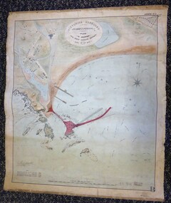
Map - Warrnambool Port 1879, 1879
... Victorian Government. Throughout the 1870s the building of a Breakwater was a major political issue in the district with preliminary work being funded and started in 1874. In 1879 the Government agreed to a further inspection of the area and an official report. Sir John Coode (1816-1892) was commissioned to make this report. He had come to Australia in 1872 to advise on harbour...This is a Plan drawn up in 1879 by Victorian Harbours to accompany Sir John Coode’s Report on the proposed Warrnambool Breakwater. ...Victorian Harbours Warrnambool Plan to accompany Sir John Coode’s report Dated 28th Feby 1879 ...The Breakwater was not the maritime success that it was hoped it would be but it is today a significant feature of our foreshore. warrnambool breakwater andrew kerr sir john coode arthur dudley dobson warrnambool Warrnambool harbour Warrnambool history Warrnambool beach Victorian Harbours Warrnambool Plan to accompany Sir John Coode’s report Dated 28th Feby 1879 This is a Plan drawn up in 1879 by Victorian Harbours to accompany Sir John Coode’s Report on the proposed Warrnambool Breakwater. ...The port facilities in Warrnambool Bay were in constant use from the first years of Warrnambool’s settlement but there were also difficulties for the shipping trade – a small and unsafe anchorage, the lack of loading facilities and little natural protection from the southerly gales. From the 1870s on there was local agitation for some sort of Breakwater to be built and an Andrew Kerr design was approved by the Warrnambool Council but no funds were made available from the Victorian Government. Throughout the 1870s the building of a Breakwater was a major political issue in the district with preliminary work being funded and started in 1874. In 1879 the Government agreed to a further inspection of the area and an official report. Sir John Coode (1816-1892) was commissioned to make this report. He had come to Australia in 1872 to advise on harbour construction. Coode recommended a 1800 feet long Breakwater and wharf connected to the shore and it was this proposal that the plan described herein and drawn up in 1879 was to accompany. The original plan was eventually modified because of the cost and a Breakwater was completed in 1890 under the direction of the engineer, Arthur Dudley Dobson, with extensions early in the 20th century. This plan is of great interest as it shows in simple graphic form the original plans proposed by Sir John Coode for the Warrnambool Breakwater. It is therefore of great historical importance. The Breakwater was not the maritime success that it was hoped it would be but it is today a significant feature of our foreshore. This is a Plan drawn up in 1879 by Victorian Harbours to accompany Sir John Coode’s Report on the proposed Warrnambool Breakwater. The chart detail is hand-drawn and hand-tinted on canvas with the names of places, geographical and marine features and local points of interest added in print. The edges of the chart are rubbed and the chart is somewhat faded and dirty but the main colours of red, green and brown are still clearly discernible. The title of the plan is printed in an oval inset at the top of the chart. The plan shows two possible Breakwater designs, one from the Borough Surveyor (Andrew Kerr?) and one from Sir John Coode.Victorian Harbours Warrnambool Plan to accompany Sir John Coode’s report Dated 28th Feby 1879 warrnambool breakwater, andrew kerr, sir john coode, arthur dudley dobson, warrnambool, warrnambool harbour, warrnambool history, warrnambool beach -
 Warrnambool and District Historical Society Inc.
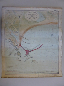
Document - Map, Warrnambool Harbour 1879, 1879
... Paper on linen map coloured, and depicting the harbour area of Warrnambool with the proposed breakwater plan in red. It has Victorian Harbours information in oval at top of map. ...In oval at top, “Victorian Harbours Warrnambool plan to accompany Sir John Coode report dated 28th Feb 1879. ...Sir john goode warrnambool harbour map warrnambool harbour map 1879 port of warrnambool map 1879 In oval at top, “Victorian Harbours Warrnambool plan to accompany Sir John Coode report dated 28th Feb 1879. ...This map shows the plans by eminent harbour engineer, Sir John Coode in 1879. Construction of the breakwater commenced in 1884 and was completed in 1890. Coode first visited Australia in 1872 when he commenced work with the Melbourne Harbour Trust to report on ways to improve Melbourne Port. He is considered one of the most eminent harbour engineers of the 19th century. His original plans for Warrnambool were revised because of cost but then subsequently found to be inadequate and later extended. This was not successful either and the harbour continues to have silting problems to this day. The Warrnambool Breakwater is of historical importance to Victoria and as this map depicts the original plans, it too has great historical significance. It is also significant with its association with Sir John Coode, who was one of the most important port engineers of the 19th century. He worked to improve ports along the Victorian coast including Portland, Geelong, Port Fairy and Lakes Entrance. While this map demonstrates the engineering skills of the era, it also reflects the limitations when natural elements are involved. Its Historical importance also lies in the depiction of items on the map which relate to Warrnambool’s early history. Paper on linen map coloured, and depicting the harbour area of Warrnambool with the proposed breakwater plan in red. It has Victorian Harbours information in oval at top of map. It shows depths of some areas.In oval at top, “Victorian Harbours Warrnambool plan to accompany Sir John Coode report dated 28th Feb 1879. Drawing No 2. Scale 500 feet to 1 inch at bottom centre. Sir John Coode signature in bottom left corner. A 33 A on bottom left reversesir john goode, warrnambool harbour map, warrnambool harbour map 1879, port of warrnambool map 1879 -
 Flagstaff Hill Maritime Museum and Village
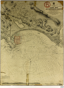
Document - Navigation Chart, Admiralty Office, Lady Bay and Warrnambool Harbour, 1893
... ...Harbour Trust...Victorian...Harbour Trust concluded that it would less costly to make repairs to prevent further damage rather than replaced the damage portion of the wall. A contract was raised in late 1924 to deposit rubble on the damaged side of the breakwater to minimise the Southern Ocean’s destructive action and work had started by August 1925. The Breakwater construction had begun in 1874 and was completed in 1890. The Victorian...Flagstaff Hill Warrnambool Flagstaff Hill Maritime Museum & Village Maritime Museum Maritime Village shipwreck coast Map chart Navigation chart plan Lady Bay Warrnambool Harbour Port of Warrnambool Breakwater Jetty Pier Dock extension proposed extension VHR H2024 1870 1893 1910 1925 Warrnambool town late 1800s Warrnambool streets late 1800s Royal Commission 1923 Public Works Water Commission Harbour Trust Victorian Harbours Sir Jon Coode Stamp, rectangular, including "AUG 1910" Stamp, double oval " - - - -CHART" Stamp, hand drawn, red circle, with "B" inside Hand written note "22-8-1910 - - - - - of surveying C. ...This navigation cart of Lady Bay and Warrnambool Harbour was originally surveyed in 1870 but this version includes the update for magnetic variation in 1893. Since the printing of the chart several annotations have been added. These include an additional stamp dated 15-8-1910, a handwritten comment across the top of the page dated August 1910, and another handwritten comment regarding the ‘Proposed Extension of Dock’ dated 19-2-1925, plus connected drawings, notes and figures. The 1925 proposal on this chart may have been a reaction to the Royal Commission of 1923, when the damaged stonework on the seaward side of the Warrnambool Breakwater, caused by the action of the sea, was the subject of enquiry. A conference between the Public Works, Water Commission and the Harbour Trust concluded that it would less costly to make repairs to prevent further damage rather than replaced the damage portion of the wall. A contract was raised in late 1924 to deposit rubble on the damaged side of the breakwater to minimise the Southern Ocean’s destructive action and work had started by August 1925. The Breakwater construction had begun in 1874 and was completed in 1890. The Victorian Government had commissioned Sir John Coode, a British harbour engineer, to present a plan to complete the Warrnambool Breakwater but his original plan was too expensive. He prepared a revised plan for a shorter structure. The construction proved to be too short to protect adequately from the weather and didn't allow enough depth for larger vessels to come into port. The decreasing trade was further affected by siltation in the bay due to the breakwater, and the completion of the railway line. The situation of the harbour became a real problem by 1910 and required continuous dredging. In 1914 the Breakwater was extended but proved to be a failure because the work began to subside and by 1920 about two thirds of the harbour was silted up. Alterations made in the 1920's increased the silting problem and by the 1940's the harbour was no longer used. More alterations were made in the 1950's and 1960's. This chart is significant for its strong connection to the maritime history of Warrnambool Harbour and Lady Bay and the Warrnambool Breakwater. The Warrnambool Breakwater is registered as a place of significance on the Victorian Heritage Database (VHR H2024). The Warrnambool Breakwater is one of the most important late 19th century maritime engineering projects in Victoria and significant in the development of Victorian coastal shipping. It is also significant for its connection with British harbour engineer, Sir John Coode. The chart is a historical record of structures existing in 1893; the Warrnambool Jetties, Warrnambool Breakwater in Lady Bay, the leading lights (lighthouses), streets, roads, bridges and many buildings. It also shows the lay of the land and seabed. Navigation Chart: Lady Bay and Warrnambool Harbour, Australia - South Coast - Victoria. Surveyed by Nav. Lieut. H.J. Stanley, R.N., 1870. Updated for Magnetic Variation, 1893. The rectangular chart is printed on heavy cream paper. Stamps are shaped rectangular, oval and round. Around the Breakwater and Jetty area are handwritten notes, dotted and joined lines, numbers and signatures, and shading of red and green. The chart shows the surrounds of Warrnambool Harbour, Lady Bay, the Breakwater and Jetty, roads, bridges and the streets in Warrnambool. It has sounding details, and angles of line from the leading lights.Stamp, rectangular, including "AUG 1910" Stamp, double oval " - - - -CHART" Stamp, hand drawn, red circle, with "B" inside Hand written note "22-8-1910 - - - - - of surveying C. Ca - - - request of 15-8-10 [initials] " Notes and lines in red pen, including a grid of sounding numbers: "1300" "1050" "1200" "Possible Extension of Dock" "19-2-25" "Dock Dredged to 20 Ft" Notes and lines in blue pen "Extension of Dock to accommodate vessels drawing 20 Feet" and "Light not visible south of this line" Red dots (4) with yellow highlight at both leading lights, breakwater and jettyflagstaff hill, warrnambool, flagstaff hill maritime museum & village, maritime museum, maritime village, shipwreck coast, map, chart, navigation chart, plan, lady bay, warrnambool harbour, port of warrnambool, breakwater, jetty, pier, dock extension, proposed extension, vhr h2024, 1870, 1893, 1910, 1925, warrnambool town late 1800s, warrnambool streets late 1800s royal commission, 1923, public works, water commission, harbour trust, victorian harbours, sir jon coode -
 Flagstaff Hill Maritime Museum and Village
Document - Report, Jet Probings, Warrnambool Harbour, 16-10-1929
... ...Harbour Trust...Victorian...The results could determine plans for future engineering works. document depth warrnambool harbour 1929 soundings jet probe jet probing seabed map of seabed underwater engineering warrnambool jetty warrnambool breakwater breakwater upgrade leading lights chart the harbour Flagstaff Hill Warrnambool Flagstaff Hill Maritime Museum & Village Maritime Museum Maritime Village shipwreck coast Lady Bay Port of Warrnambool Breakwater Jetty Pier VHR H2024 Royal Commission 1923 Public Works Water Commission Harbour Trust Victorian Harbours Report, titled 'Jet Probings, Warrnambool Harbour'. ...This report lists the depths of water and the consistency of the seabed surrounding the Warrnambool Harbour in October 1929, The information, often referred to as 'soundings', was obtained by Jet Probing,. In earlier days a lead line was used to perform a similar task. The author of the document is unknown. Jet Probing is a method used for underwater archaeology, cable installation and coastal engineering. A jet probe is a machine that produces a strong jet of water that penetrates the layers of sediment on the seabed, determining their depth, thickness and consistency. It provides a survey of the seabed and can be used as an aid to engineering design and construction. The report mentions lining up with the wooden jetty, the end of the breakwater and the leading lights. It mentions sand, loose rock and rock. It tells of stopping work due to the water being too rough, the pipe choking, difficulty in connecting pipes, and pipe joint breaking as it tried to get through the sand, The report in the document is significant for its connection with the Warrnambool Harbour, Warrnambool Breakwater, Warrnambool Jetty and Lady Bay. The report gives figures for the depth and consistency of the water and seabed at a particular point in time and can be used to compart with similar figures taken at different times. The results could determine plans for future engineering works.Report, titled 'Jet Probings, Warrnambool Harbour'. Two pages of cream coloured paper with hand written notes in pen and ink. Report covers three days of Jet Probings, with resulting figures and comments, for the depths of the surroundings of the Warrnambool Harbour. The report is in point form, with some underlining. Dates of recordings are 14-10-29, 15-10-29 and 16-10-29. (1929) The situation of the harbour had become a real problem by 1910 and required continuous dredging. In 1914 the Breakwater was extended but proved to be a failure because the work began to subside and by 1920 about two thirds of the harbour was silted up. Alterations made in the 1920's increased the silting problem. The soundings and Jet Probings were done after the Royal Commission of 1923, when the damaged stonework on the seaward side of the Warrnambool Breakwater, caused by the action of the sea, was the subject of enquiry. A conference between the Public Works, Water Commission and the Harbour Trust concluded that it would less costly to make repairs to prevent further damage rather than replaced the damage portion of the wall. A contract was raised in late 1924 to deposit rubble on the damaged side of the breakwater to minimise the Southern Ocean’s destructive action and work had started by August 1925. By the 1940's the harbour was no longer used. More alterations were made in the 1950's and 1960's. document, depth, warrnambool harbour, 1929, soundings, jet probe, jet probing, seabed, map of seabed, underwater engineering, warrnambool jetty, warrnambool breakwater, breakwater upgrade, leading lights, chart the harbour, flagstaff hill, warrnambool, flagstaff hill maritime museum & village, maritime museum, maritime village, shipwreck coast, lady bay, port of warrnambool, breakwater, jetty, pier, vhr h2024, royal commission, 1923, public works, water commission, harbour trust, victorian harbours -
 Glenelg Shire Council Cultural Collection
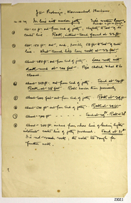
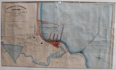
Work on paper - Drawing No. 2, Plan Shewing Works Recommended by Sir John Coode, 1879
... Top left: Victorian Harbours / Portland / Plan Shewing Works Recommended by / Sir John Coode / in his report dated Dec r 1879 / The proposed works shown by red colour / the extensions to be undertaken in the first instance across by red colour / subsequent extensions and reclamations are coloured brown Top Right: Drawing No. 2 Portland Borough Council stamped top left...Glenelg Shire Council Cultural Collection History House Cliff Street Portland great-ocean-road Portland Harbour Sir John Coode Portland Plans Drawings 1800s Top left: Victorian Harbours / Portland / Plan Shewing Works Recommended by / Sir John Coode / in his report dated Dec r 1879 / The proposed works shown by red colour / the extensions to be undertaken in the first instance across by red colour / subsequent extensions and reclamations are coloured brown Top Right: Drawing No. 2 Portland Borough Council stamped top left Drawing of Portland Bay showing the proposed harbour. ...Drawing of Portland Bay showing the proposed harbour. Portland town centre is shown as it Portland Botanic Gardens and Battery Hill.Top left: Victorian Harbours / Portland / Plan Shewing Works Recommended by / Sir John Coode / in his report dated Dec r 1879 / The proposed works shown by red colour / the extensions to be undertaken in the first instance across by red colour / subsequent extensions and reclamations are coloured brown Top Right: Drawing No. 2 Portland Borough Council stamped top leftportland harbour, sir john coode, portland, plans, drawings, 1800s -
 Williamstown Historical Society Inc
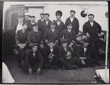
Photograph - Photograph of the Lady Loch crew
... It was originally used by the Victorian Ports and Harbours Branch for coastal and bay work. ...It was originally used by the Victorian Ports and Harbours Branch for coastal and bay work. ...SS Lady Loch was built in Melbourne, in Footscray, by Anderson Campbell. The ship was named after Lady Elizabeth Loch, wife of Sir Henry Loch, Governor of Victoria from 1884 -1889. It was originally used by the Victorian Ports and Harbours Branch for coastal and bay work. By 1908 it was being used as a Commonealth lighthouse tender.Large black and white group photograph of 16 male crew members of the 'Lady Loch', a Lighthouse Tender which docked at Williamstown. Crew shown in photograph: BACK ROW, L to R: J. McEWan, cook; Unknown: Mr. Prince, steward; Unknown; Unknown; Mr. Nelson, fireman; Unkown CENTRE ROW, L to R: Mr. Bradley, 2nd officer; Captain Bolger; Mr.Trace, 1st officer (later captain); Unknown; Unkkown FRONT ROW, L to R: Unknown; Clarence "chicken" Young, seaman (later father of Betty Young) (Unknown); Doug Geary" "Lady Loch" crew" -
 Williamstown Historical Society Inc
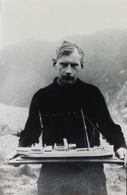
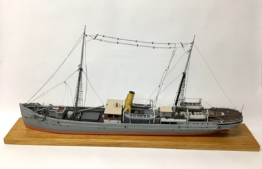
Photograph - Model ship "Lady Loch" with maker
... It was originally used by the Victorian Ports and Harbours Branch for coastal and bay work. ...It was originally used by the Victorian Ports and Harbours Branch for coastal and bay work. ...SS Lady Loch was built in Melbourne, in Footscray, by Anderson Campbell. The ship was named after Lady Elizabeth Loch, wife of Sir Henry Loch, Governor of Victoria from 1884 -1889. It was originally used by the Victorian Ports and Harbours Branch for coastal and bay work. By 1908 it was being used as a Commonealth lighthouse tender. The maker of the "Lady Loch" model, holding his model. He was reputed to be a Polish crewman on the ship. He is dressed in a dark jumper, with a view of waves and a rugged coastline in the background. model maker, model ship, lady loch -
 Williamstown Historical Society Inc
Model - Ship model 'Lady Loch', 1946
... It was originally used by the Victorian Ports and Harbours Branch for coastal and bay work. ...It was originally used by the Victorian Ports and Harbours Branch for coastal and bay work. ...SS Lady Loch was built in Melbourne, in Footscray, by Anderson Campbell. The ship was named after Lady Elizabeth Loch, wife of Sir Henry Loch, Governor of Victoria from 1884 -1889. It was originally used by the Victorian Ports and Harbours Branch for coastal and bay work. By 1908 it was being used as a Commonealth lighthouse tender. Made by an unnamed maker, believed to be a Polish seaman who worked on board the Lady Loch.Model of the steam ship “Lady Loch”, painted grey, red below waterline, two masts, rattlins on side shrouds, single funnel, two lifeboats port and starboard, varnished bridge coach house, boom on foremast, anchor catted at bow port and starboard, radio aerials strung between masts.On bow: "LADY LOCH" -
 Williamstown Historical Society Inc
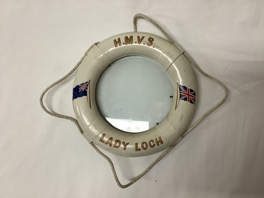
Domestic object - Picture frame, HMVS Lady Loch
... Owned by Victorian Ports and Harbours Dept. ...Owned by Victorian Ports and Harbours Dept. "H.M.V.S. Lady Loch" Picture frame shaped as a life buoy, with rope decoration, under glasss, decorated with the Australian and UK flags. ...The lighthouse tender "Lady Loch" was built in 1886 by Campbell, Sloss & McCann in Footscray, for the Victorian Dept of Public Works. The ship was named after Lady Elizabeth Loch, wife of Sir Henry Loch, Governor of Victoria from 1884 -1889. It was an iron steamship of 531 tons. Built for use as a lighthouse tender, it serviced lighthouses around the south east coast and Tasmania and was docked at Williamstown. Owned by Victorian Ports and Harbours Dept. Picture frame shaped as a life buoy, with rope decoration, under glasss, decorated with the Australian and UK flags."H.M.V.S. Lady Loch" -
 Williamstown Historical Society Inc
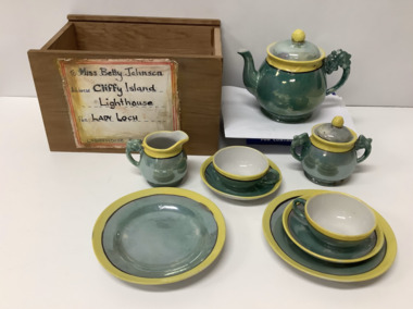
Domestic object - Child's ceramic tea set
... Owned by Victorian Ports and Harbours Department. Register closed in September 1935 when the vessel was converted to a hulk at Brisbane. ...Owned by Victorian Ports and Harbours Department. Register closed in September 1935 when the vessel was converted to a hulk at Brisbane. ...The Lady Loch was a Lighthouse Tender built in 1886 by Campbell, Sloss & McCann in Footscray, for the Victorian Dept. of Public Works. The ship was named after Lady Elizabeth Loch, wife of Sir Henry Loch, Governor of Victoria from 1884 -1889. It was an iron Steamship of 531 tons. Built for use as a lighthouse tender and serviced lighthouses around the south east coast and Tasmania. Owned by Victorian Ports and Harbours Department. Register closed in September 1935 when the vessel was converted to a hulk at Brisbane. Official Number: 88946 Length: 182' Plywood box containing a child's Japanese ceramic toy tea set. Total of eleven pieces in irridescent green ceramic with yellow and black decorative edges. The plywood box is not original. Comprises: One teapot with lid One sugar bowl with lid One milk jug Two cups and saucers Two side platesOn teapot, milk jug, two plates and saucers: ''Made in Japan'' . Address label on front of the box: "To Miss Betty/Johnson/Cliffy Island Lighthouse/Lady Loch" -
 Williamstown Historical Society Inc
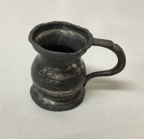
Domestic object - Pewter rum measure
... Owned by Victorian Ports and Harbours Dept. Register closed in September 1935 when the vessel was converted to a hulk at Brisbane. ...Owned by Victorian Ports and Harbours Dept. Register closed in September 1935 when the vessel was converted to a hulk at Brisbane. ...The lighthouse Tender "Lady Loch" was built in 1886 by Campbell, Sloss & McCann in Footscray, for the Victorian Dept of Public Works. It was an iron steamship of 531 tons. The ship was named after Lady Elizabeth Loch, wife of Sir Henry Loch, Governor of Victoria from 1884 -1889. Built for use as a lighthouse tender, it serviced lighthouses around the south east coast and Tasmania and was docked at Williamstown. Owned by Victorian Ports and Harbours Dept. Register closed in September 1935 when the vessel was converted to a hulk at Brisbane. Official Number: 88946. A tot of rum measered an 1/8 of a pint or 71 ml, and was traditionally the daily ration issued to British Royal Navy sailors, a tradition that was common on many ships. Small pewter measure for a tot of rum, shaped like a flagon, with a handle. From SS Lady Loch, Tasmanian lighthouse tender. -
 Flagstaff Hill Maritime Museum and Village
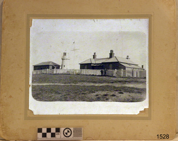
Photograph - Historical, building, Late 19th to early 20th century
... The Lighthouses were categorised as harbour lights rather than coastal lights, so they remain under the control of the Victorian Government’s Ports and Harbours section. ...The Lighthouses were categorised as harbour lights rather than coastal lights, so they remain under the control of the Victorian Government’s Ports and Harbours section. ...The black and white photograph depicts the Lady Bay Lighthouse Complex at Flagstaff Hill, Warrnambool. It was opened on this site in 1871. From left to right, the Chartroom (previously named the Store), Upper Lighthouse, Flagstaff, Lighthouse Keeper's Quarters. The bluestone buildings are facing North on Merri Street. The Harbour Pilot's Lodgings were on the east of the Complex. There are two unknown male figures standing in front of the light-coloured picket fence that encompasses the Complex. The photograph is mounted on card. WARRNAMBOOL'S LADY BAY LIGHTHOUSES In the 1800s ships sailing from England to Australia began to use Bass Strait as a faster route to Melbourne. Small navigation errors led to many tragic shipwrecks. From 1848 lighthouses were operating along Victoria’s southern coast as a guide for sailors. Coastal towns such as Warrnambool grew and the exchange of trade and passengers was of great benefit. However, the uncertain weather changes, relatively shallow waters and treacherous, hidden rocky reefs were not really suitable for a Harbour and in the 1840s and 1850s, there were many shipwrecks in the area, with some even stranded in its Lady Bay harbour. A jetty was built in 1850 and a flagstaff to guide seafarers was placed up high on what became known now as Flagstaff Hill. In November 1857 the Victorian Government recommended that Warrnambool Harbour had beacons and two lighthouses to guide vessels into and out of the Harbour safely. The white light of the Middle Island lighthouse was to be used for the first time on September 1, 1859. The red light of the Beach Lighthouse, a wooden obelisk structure, was first operated on March 25, 1860, but in 1868 this light was ‘discontinued’ due to it being too low. Melbourne’s Department of Public Works decided to relocate the Middle Island Lighthouse Complex - Lighthouse, Keeper’s Quarters, Privy, Store Room and even water tanks - to Flagstaff Hill. The lower obelisk was shortened, and a protruding gallery, railing, and external ladder were added, and the light from the Beach Lighthouse. A green guiding light was erected on the end of the jetty. The transfer of the Complex began in March 1871. Each shaped stone of the lighthouse was carefully numbered, removed then reassembled on Flagstaff Hill. In 1872 the well was sunk behind the Lighthouse Keeper’s Cottage. The Keepers and families had left Middle Island in April and moved to Flagstaff Hill in October 1871. Vessels entering Lady Bay align the Upper and Lower Lighthouse towers during the day and the lights at night. The Upper Lighthouse is a round tower, and the Lower Light is square. The Lighthouses were categorised as harbour lights rather than coastal lights, so they remain under the control of the Victorian Government’s Ports and Harbours section. The lights were originally powered by oil, then acetylene gas, later by electricity, and then converted to solar power in 1988. In 1993 the solar panel was replaced by a battery charger. A decision was made in 1936 to replace the lighthouses’ lights with unattended lights that no longer required Keepers and Assistants. At least 29 Keepers had attended to the lighthouse from its opening in 1859 to when the last official Lightkeepers left In April 1916. The Warrnambool Harbour Board rented out the Quarters from 1916 to 1936. The Board closed down but the rentals continued with other unknown landlords. In the 1970s the Flagstaff Hill Planning Board was set up under the chairmanship of John Lindsay. The Board was to make recommendations to the Warrnambool City Council regarding using the buildings and the rest of the Crown Land on the site. The Flagstaff Hill Maritime Village opened in 1975 and began renovating the Cottage in stages, during which time evidence of a 1920s fire was found in the eastern section of the cottage. Additions of a porch on the west and a washroom on the east were made in the 1980s. The western part of the building is now a Shipwreck Museum and the east has returned to a late 19th-century Lighthouse Keeper’s cottage and includes the screen made by Assistant Lighthouse Keeper Thomas Hope in the late 19th century. He served as Assistant Keeper in Warrnambool for two periods.The Warrnambool Lighthouse Complex is now listed on the Victorian Heritage Register, H1520, for being of historical, scientific (technological) and architectural significance to the State of Victoria. The Complex is significant as an example of early colonial development. The buildings are significant for their connection with the important navigational function of the Lighthouses, a function still being performed to this day. The buildings are also significant as an example of structures designed and works carried out by the Public Works Department in Victoria in the mid-to-late 19th century. The structures still stand strong. Photograph; Warrnambool Lighthouse Keeper's cottage, lighthouse, flagstaff and chartroom at Flagstaff Hill, and a light-coloured picket fence with gate. Two male figures are in front of the fence. Black and white print glued to a yellow card. The inscription is indecipherable. The right side of the cottage has a built-in, enclosed addition.Ink stamped in lower right hand corner, too faded to be legible.flagstaff hill, flagstaff hill maritime museum, flagstaff hill maritime village, warrnambool, maritime museum, shipwreck coast, lighthouse keeper's cottage, lighthouse residence, lighthouse, chart room, quarters, privy, middle island, beach lighthouse, obelisk, lighthouse complex, lady bay complex, warrnambool port, warrnambool harbour, lady bay, keepers, lighthouse keeper, upper lighthouse, lower lighthouse, assistant keeper, ports and harbours, cottage, light keeper -
 Flagstaff Hill Maritime Museum and Village
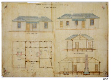
Document - Plans, Lighthouse Keeper's Quarters Warrnambool, 1858-1909
... The Lighthouses were categorised as harbour lights rather than coastal lights, so they remain under the control of the Victorian Government’s Ports and Harbours section. ...The Lighthouses were categorised as harbour lights rather than coastal lights, so they remain under the control of the Victorian Government’s Ports and Harbours section. ...The set of seven 1858 plans shows proposed plans for the original Lighthouse Complex that was built on Middle Island in 1858-1859. The whole complex was then transferred to Flagstaff Hill in 1871. The plan, dated 1909, is for proposed additions and repairs to the Quarters at Flagstaff Hill. The plan 'Alterations and Additions' shows alternate plans for changes to the quarters at the Flagstaff Hill location. This plan has no date. The Complex comprised the Lighthouse, the Lighthouse Keepers’ Quarters, the Store (now called the Chart Room) and a Privy, which was not included in these plans. The Keeper’s bluestone Quarters was a cottage divided into two compartments, one for each keeper and his family. The bluestone Store was divided into three; a store, a workshop an oil store (or office). The Privy comprised of a small building also divided into two separate, back-to-back toilets, one for each Keeper and his family. The Flagstaff Hill Keeper's Quarters have had extensions and additions at various times, and these have also been removed at various other times. THE PLANS - *Dec. 1858 (12/58) ‘Lighthouse Keepers Quarters No.2 Warrnambool’ (2375.01)* Public Works Office Melbourne – Front and Back elevations, sections, and floor plan. The drawing shows timber walls. [The floor plan is the closest plan to the current building, however, the walls are timber in this plan.] *Nov. 1858 – No.3 ‘Lighthouse Keepers Quarters Warrnambool’ (2375.02)* Office of Public Works, Melbourne – Back and End elevations and section through. The drawing shows stone walls. One side; Senior Keeper’s bedroom, living room and kitchen with storeroom. Another side; is the Assistant’s bedroom, living room and storeroom. *Nov. 1858 - No.4 ‘Lighthouse Stores Warrnambool’ (2375.03)* Office of Public Works – Front, Side and end elevations, centre section. The drawing shows stone walls. *Nov. 1858 – No.4, ‘Lighthouse Stores No. 2 Warrnambool’ (2375.04)* Office of Public Works – Front, side and end elevations, centre section. The drawing shows timber walls. *Nov. 1858 – ‘Details Lighthouse Keepers Quarters No. 2 Warrnambool’ (2375.05)* Public Works Office Melbourne. The plan shows the foundations, joists and eaves. The drawing shows timber walls. (Nov. 1858 – ‘No.4 ‘Lighthouse No. 2 – Warrnambool’ (2375.06)* Public Works Melbourne (Part of the paper is missing). This plan shows an octagonal tower, internal stairs, a balcony landing, and a weather vane on top. *November 1858 – No. 1, ‘Lighthouse – Warrnambool’ (2375.07)* Office of Public Works Melbourne. This plan shows a round tower, including the stairs, windows on the tower and the weather vane on the top. *4/3/9 [1909] – ‘Additions and Repairs, Lighthouse Quarters, Warrnambool, General Plan’ (2375.8)* Department of Public Works Melbourne’s official stamp is signed by Croft. It shows the floor plans of the Store, Upper Lighthouse and the Quarters. The Store building has three sections; a Store, Work-Shop and Office, with an internal wall between them and separate entries. The Quarters are divided into two dwellings. The Senior Keeper’s side on the left has fireplaces in two of the three bedrooms and there is a pantry and wash house. The Assistant’s side has no fireplaces in the bedrooms and there’s no pantry or washhouse. These plans include proposed changes to the buildings. The Senior Keeper’s Quarters would have a partition on bedroom 2, a bath with plumbing and drainage, a wall moved and a built-in side porch. The Store would also have a built-in porch. The undated plan 'Additions and Alterations' (2375.9) shows alternative arrangements for water tanks, plumbing and such. WARRNAMBOOL'S LADY BAY LIGHTHOUSES- In the 1800s ships sailing from England to Australia began to use Bass Strait as a faster route to Melbourne. Small navigation errors led to many tragic shipwrecks. From 1848 lighthouses were operating along Victoria’s southern coast as a guide for sailors. Coastal towns such as Warrnambool grew and the exchange of trade and passengers were of great benefit. However, the uncertain weather changes, relatively shallow waters and treacherous, hidden rocky reefs were not suitable for a Harbour and in the 1840s and 1850s there were many shipwrecks in the area, with some even stranded in its Lady Bay harbour. A jetty was built in 1850 and a flagstaff to guide seafarers was placed up high on what became known now as Flagstaff Hill. In November 1857 the Victorian Government recommended that Warrnambool Harbour had beacons and two lighthouses to guide vessels into and out of the Harbour safely. The white light of the Middle Island lighthouse was to be used for the first time on September 1, 1859. The red light of the Beach Lighthouse, a wooden obelisk structure, was first operated on March 25, 1860, but in 1868 this light was ‘discontinued’ due to it being too low. Melbourne’s Department of Public Works decided to relocate the Middle Island Lighthouse Complex - Lighthouse, Keeper’s Quarters, Privy, Store Room and even water tanks - to Flagstaff Hill. The lower obelisk was shortened, and a protruding gallery, railing, and external ladder were added, as well as the light from the Beach Lighthouse. A green guiding light was erected on the end of the jetty. The transfer of the Complex began in March 1871. Each shaped stone of the lighthouse was carefully numbered, removed then reassembled on Flagstaff Hill. In 1872 the well was sunk behind the Lighthouse Keeper’s Cottage. The Keepers and families had left Middle Island in April and moved to Flagstaff Hill in October 1871. Vessels entering Lady Bay align the Upper and Lower Lighthouse towers during the day and the lights at night. The Upper Lighthouse is a round tower, the Lower Light is square. The Lighthouses were categorised as harbour lights rather than coastal lights, so they remain under the control of the Victorian Government’s Ports and Harbours section. The lights were originally powered by oil, then acetylene gas, later by electricity, and then converted to solar power in 1988. In 1993 the solar panel was replaced by a battery charger. A decision was made in 1936 to replace the lighthouses’ lights with unattended lights that no longer required Keepers and Assistants. At least 29 Keepers had attended to the lighthouse from its opening in 1859 to when the last official Lightkeepers left In April 1916. The Warrnambool Harbour Board rented out the Quarters from 1916 to 1936. The Board closed down but the rentals continued with other unknown landlords. In the 1970s the Flagstaff Hill Planning Board was set up under the chairmanship of John Lindsay. The Board was to make recommendations to the Warrnambool City Council regarding the use of the buildings and the rest of the Crown Land on the site. The Flagstaff Hill Maritime Village opened in 1975 and began renovating the Cottage in stages, during which time evidence of a 1920s fire was found in the eastern section of the cottage. Additions of a porch on the west and a washroom on the east were made in the 1980s. The western part of the building is now a Shipwreck Museum and the east has returned to a late 19th-century Lighthouse Keeper’s cottage and includes the screen made by Assistant Lighthouse Keeper Thomas Hope during one of his two periods of service there. THE LIGHTHOUSE KEEPERS Lighthouse Keepers were responsible for keeping their Lighthouse’s lights shining at night. They kept a lookout for passing vessels and changes in weather. They were expected to clean, polish and maintain the equipment and buildings. They kept regular and detailed records of who was on watch, and the time the light was lit, trimmed and extinguished. They kept a journal about other events that occurred. They keep regular, accurate Meteorological Logs. It was expected that they were competent in Morse code signalling. They would be called to help in times of disasters and shipwrecks, and to give official statements about these events. Many Lighthouse Keepers also volunteered as members of the lifeboat crew. The Lady Bay lighthouses were officially classified as small, so the Keepers had the official titles of Senior Assistant Lighthouse Keeper and Assistant Lighthouse Keeper. They were employed by the Public Service and paid rent to live in the Lighthouse Quarters. They were compulsorily retired at the age of 60, with most receiving a superannuation payment. Despite their time-consuming duties, there was time to follow hobbies and crafts such as growing vegetables, playing musical instruments, making models of buildings including lighthouses, and crafting furniture pieces. An example of a keeper’s skills is the carved fire screen made by /assistant Keeper Thomas Hope in the early 20th century and displayed in the Lighthouse Keeper’s cottage at Flagstaff Hill. The last occupants of the Middle Island Complex were Senior Keeper Robert Deverell, his Assistant Keeper, Andrew Farncombe, and their families. They all became the first occupants at the Lady Bay Lighthouse Keepers’ Quarters on Merri Street. The Warrnambool Lighthouse Complex plans are the origin of what is now the Lady Bay Lighthouse Complex. They are a record of the people, process and departments involved in bringing the complex into fruition. The plans are significant to the Complex, which is now listed on the Victorian Heritage Register, H1520, for being of historical, scientific (technological) and architectural significance to the State of Victoria. The Complex is significant as an example of early colonial development. The plan are significant for their connection with the important navigational function of the Lighthouses, a function still being performed to this day. The plans are also significant as an example of a product from the Public Works Department in Victoria in the mid-to-late 19th century. The structures built to these plans still stand strong. Plans for the Lighthouse Complex in Warrnambool, including Lighthouses, Keeper's Quarters and Stores. Seven of the plans are on thin fragile paper, one is on thicker, stronger paper. The drawings have been made in pens coloured red and black. They originate from Public Works in Melbourne. Seven were drawn in 1858, one in 1904, the other is not dated.Dec. 1858 - Lighthouse Keepers Quarters No.2 Warrnambool. Public Works Office Melbourne. Nov. 1858 - No.3 ‘Lighthouse Keepers Quarters Warrnambool. Public Works Office Melbourne. Nov. 1858 - No.4 ‘Lighthouse Stores Warrnambool. Office of Public Works. Nov. 1858 - No.4, ‘Lighthouse Stores No. 2 Warrnambool. Office of Public Works. Nov. 1858 - Details Lighthouse Keepers Quarters No. 2 Warrnambool. Public Works Office Melbourne. Nov. 1858 - No.4 ‘Lighthouse No. 2 – Warrnambool. Public Works Melbourne. Nov. 1858 - No. 1, Lighthouse - Warrnambool. Office of Public Works Melbourne. 4/3/9 [1909] - Additions and Repairs, Lighthouse Quarters, Warrnambool, General Plan. Department of Public Works Melbourne. SIGNED "Croft" "15A" on reverse [no date] - Lighthouse Quarters Warrnambool, Additions and Alterations. "9A" on reverseflagstaff hill, warrnambool, lighthouse keeper's cottage, lighthouse residence, lighthouse, plans, public works, melbourne, flagstaff hill maritime museum, maritime museum, shipwreck coast, flagstaff hill maritime village, chart room, quarters, privy, middle island, beach lighthouse, obelisk, lighthouse keeper, assistant keeper, lighthouse complex, lady bay, lady bay complex, keepers, upper lighthouse, lower lighthouse, ports and harbours, cottage, harbour board, flagstaff hill planning board, meteorological record, robert deverell, andrew farncombe, warrnambool port, warrnambool harbour, residence, alterations, repairs, department of works, light keeper -
 Warrnambool and District Historical Society Inc.
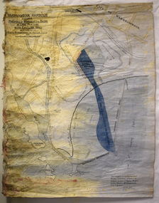
Map - Map of Proposed Alterations to Warrnambool Harbour 1925, Warrnambool Harbour Committee, Warrnambool Harbour Proposed Wharves and Basin in Lake Pertobe with Eastern Wall, 1925
... The main features of the proposal were the extension of the Eastern Wall to almost enclose the harbour and a basin in Lake Pertobe. The design was to be placed before the Victorian Royal Commission on the Outer Ports which was established partly to examine the allegations of unsatisfactory work carried out in Warrnambool when the Breakwater was extended 300 feet in 1914 and also to make recommendations regarding all regional ports. ...The main features of the proposal were the extension of the Eastern Wall to almost enclose the harbour and a basin in Lake Pertobe. The design was to be placed before the Victorian Royal Commission on the Outer Ports which was established partly to examine the allegations of unsatisfactory work carried out in Warrnambool when the Breakwater was extended 300 feet in 1914 and also to make recommendations regarding all regional ports. ...This map was printed in 1925 and contains the Warrnambool Harbour alterations proposed by the Warrnambool Harbour Committee incorporating the original designs of Captain Menzies, the Warrnambool Harbour Master and the City Engineer, Mr A. Lavercombe. The main features of the proposal were the extension of the Eastern Wall to almost enclose the harbour and a basin in Lake Pertobe. The design was to be placed before the Victorian Royal Commission on the Outer Ports which was established partly to examine the allegations of unsatisfactory work carried out in Warrnambool when the Breakwater was extended 300 feet in 1914 and also to make recommendations regarding all regional ports. The Warrnambool Breakwater was completed in 1890 but failed to provide the shipping conditions needed to continue Warrnambool as a viable port. Many plans and proposals for port improvement such as this one were produced in the late 19th century and the first half of the 20th century with the port officially closed in the 1940s. Still today the Breakwater and Warrnambool Harbour conditions remain a source of contention.This map is significant as it shows a 1925 design for Warrnambool Harbour hitherto little-known. It also has markings showing land sites of the time (BayView Hotel, Woollen Mill etc.)This is a map made of thick yellow paper pasted onto a cloth backing. It has two cloth tags at the top for tying up the map when folded. It appears to be a hand-drawn map copied with printed material added. The map is shaded green and red in some areas. Attached by nails to the map are wooden frames, rounded at the bottom and partly curved at the top. The map is torn and partly detached at the top. The top frame has a cord attached for hanging the map.warrnambool harbour, captain menzies, a.lavercombe city engineer, warrnambool breakwater, royal commission on outer ports -
 Warrnambool and District Historical Society Inc.
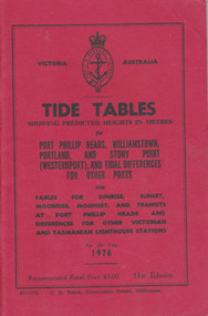
Booklet, Tide Tables, For the year 1976
... Victorian and Tasmanian Lighthouse stations. Red card wrap around cover. 92 cream coloured pages held with 2 staples. Black print. Ports and harbour ...Yearly publication showing predicted heights in metres for Port Phillip Heads, Williamstown, Portland and Stony Point (Westernport) and tidal differences for other Ports.This booklet provides tide and port information for the coastline of Victoria for the year 1976. It also has information on other aspects of weather such as wind, cloud and sea descriptions. These booklets were a useful reference for fishermen and those involved in boating along the coast of Victoria. They are published in digital form today.Sold at Stan McPhee Sports store Liebig St Warrnambool Vic showing local tides. Red card wrap around cover. 92 cream coloured pages held with 2 staples. Black print. Ports and harbour seal on the frontBooksellers stamp: ink. blue Stan McPhee Sports, green Liebig St Vic. red ...2953. 6717/75. C.H. Rixon, Government Printer, Melbourne. 51st Edition. Recommended price $3.00. Tables for Sunrise, Sunset/moonrise, moonset and transits at Port Phillip Heads & differences for other Victorian and Tasmanian Lighthouse stations.tide table, warrnambool tide table 1976, southern victorian tides -
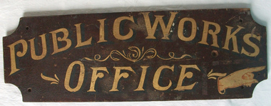 Warrnambool and District Historical Society Inc.
Sign - Public Works Office
... harbour,and water supplies. Much of this work was managed through local offices such as the one at Warrnambool. The sign on the reverse which states Witnesses Waiting Room relates to the court house which is where this sign originated.The Warrnambool court house was built in 1870-71 by the Victorian Public Works department and it is possible that this sign relates to that period.It is one of a number of public buildings built in the period 1870-1890 including the Police station and stables and police quarters, the Post Office and drill Hall , all in the same vicinity. ...harbour,and water supplies. Much of this work was managed through local offices such as the one at Warrnambool. The sign on the reverse which states Witnesses Waiting Room relates to the court house which is where this sign originated.The Warrnambool court house was built in 1870-71 by the Victorian Public Works department and it is possible that this sign relates to that period.It is one of a number of public buildings built in the period 1870-1890 including the Police station and stables and police quarters, the Post Office and drill Hall , all in the same vicinity. ...This sign points has two different messages. The first states Public Works Office, which was operational in Victoria between 1855 and 1987 dealt with many aspects of the states infrastructure. It had many different reponsibilities and roles from building government accommodation and fit out of buildings, licences for unused roads and water ways, main roads and bridges, ports and harbour,and water supplies. Much of this work was managed through local offices such as the one at Warrnambool. The sign on the reverse which states Witnesses Waiting Room relates to the court house which is where this sign originated.The Warrnambool court house was built in 1870-71 by the Victorian Public Works department and it is possible that this sign relates to that period.It is one of a number of public buildings built in the period 1870-1890 including the Police station and stables and police quarters, the Post Office and drill Hall , all in the same vicinity. This building reflects the growth of the town and also the importance it held at the time from a state level. The building while no longer used as a court house is a building of significance to Warrnambool as well as to the state of Victoria, being one of six around the state which were built in free classical style. This sign denotes the waiting room for witnesses which was situated on the western side of the building.A tangible link which provides historical and social significance to Warrnambool.Rectangular wooden sign with rounded corners. There is text on both sides painted in gold paint with shadow in black. One side is a darker brown stain . There are screw holes in each corner.and one hole on left middle of sign. Rounded edge on one side.Side 1:Witnesses Waiting Room Side 2:Public Works Office.warrnambool, warrnambool court house, public works department warrnambool -
 Glen Eira Historical Society
Document - Bell, Agnes Paton
... Victorian Historical Magazine'... Caulfield Road... 'The Origin of the name of Caulfield'... 'Naming of Caulfield'... Kilpatrick Anne... University of Melbourne... Bell Gavin... 'Road District'... Bell Nan Dr.... Australian Women's Weekly... Adult Education... Students... Tertiary Education... Templeton William J.P.... Melbourne Harbour...Glen Eira Crotonhurst Rosecraddock Caulfield Caulfield Military Hospital Harleston Grimwade House Centenary of Caulfield Mansions Bell George Mrs Bell Agnes Paton Nelson H G Grimwade Caulfield John Ricketson Webb Langdon Webb-Langdon Violet 'Melbourne - John Batman's Village' 'The Victorian Historical Magazine' Caulfield Road 'The Origin of the name of Caulfield' 'Naming of Caulfield' Kilpatrick Anne University of Melbourne Bell Gavin 'Road District' Bell Nan Dr. Australian Women's Weekly Adult Education Students Tertiary Education Templeton William J.P. Melbourne Harbour ...This file contains 3 items relating to Caulfield historian Agnes Paton Bell: 1/Newspaper article (undated and unsourced) on a history of Caulfield, written by Mrs George Bell to mark the Centenary of Caulfield. This was published prior to 14/02/1966 as the reverse shows prices in pounds sterling. 2/Research notes by GEHS volunteer, dated 11/07/2014, listing items held in the GEHS collection written by Agnes Paton Bell regarding the histories of Melbourne and Caulfield. 3/Copy of an article from the Australian Women's Weekly, dated 27/10/1965 titled 'History is Her Hobby', obtained from the National Library of Australia. The article details Bell's university studies, her historical work, including about the history of Caulfield, and her childhood in Scotland. The article includes two photos - one of Bell at her desk, the other of her and her husband George Bell in his woodworking workshop.glen eira, crotonhurst, rosecraddock, caulfield, caulfield military hospital, harleston, grimwade house, centenary of caulfield, mansions, bell george mrs, bell agnes paton, nelson h g, grimwade, caulfield john, ricketson, webb, langdon, webb-langdon violet, 'melbourne - john batman's village', 'the victorian historical magazine', caulfield road, 'the origin of the name of caulfield', 'naming of caulfield', kilpatrick anne, university of melbourne, bell gavin, 'road district', bell nan dr., australian women's weekly, adult education, students, tertiary education, templeton william j.p., melbourne harbour trust, elsternwick, historical writing, suffragettes, bell george mrs -
 Mission to Seafarers Victoria
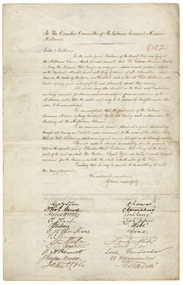
Letter - Petition, October November 1897
... The need for a new facility was a result of changes in shipping and the use of the Melbourne ports in the 1890's and this document supported the pressure on the Harbour offices to finally release land for an appropriate building in the early 20th C. victoria melbourne ships petition australia-wharf captains signatures 717-flinders-street-docklands maritime welfare services mission to seafarers seamen's mission mission to seamen mermerus captain coles sir john coode loch line loch ness loch gary loch ryan ss warrnambool loch tay loch vennachar matador nesaia d. gerckens h. petersen a.f. svhanstrom hermes ariel loch katrine william anderson dharwar narcissus hebe anna hinemoa sophocles carmanian captains' petition In cursive handwriting: To The Executive Committee of the Victorian Seamans Mission', / Melbourne / Ladies and Gentlemen / we the undersigned captains....... ...This document reveals the way in which Mission to Seafarers grew in response to demand. With increased shipping to Australia for all purposes, the need for the then existing Mission to grow to be conveniently located and to accommodate seafarers became increasingly evident. This document also shows the formal nature of documents and petitions in the 1890s and documents the names of twenty-two contemporaneous ships and their respective captains. The Anna, Dharwar and Mermerus arrived in port at the end of July 1897. The Carmanina arrived on the 21 October 1897. The Loch Katrine, at the end of the list, arrived on 5 November 1897. The letter was published in the Argus, 22 December 1897: "APPEAL FOR SEAMEN. TO THE EDITOR OF THE ARGUS. Sir, I beg that in the interests of the Victorian Seamen's Mission you will be kind enough to publish the appended testimony of the ship masters who for many years have been trading to this port, and therefore have had many opportunities of judging the effects of his work. The mission has much need of monetary assistance, and, should any of your numenous leaders deem it worthy of support, the committee would feel most grateful for any help that may be given in this direction. It has been the pleasure of the committee as far as possible to supply the crews of all outward bound steamers and sailing vessels with literature for their use on the voyage. My former appeals through your columns for leading matter have always been liberally responded to, and I trust that should any of our booksellers have any surplus stock of periodicals, religious and secular, illustrated or otherwise, at the end of the year, they will kindly remember the Victorian Seamen's Mission and the sailors. Private individuals also who may have stacks of literature by them, if they would kindly send some to the Seamen's Institute, Beach street, Port Melbourne, would cause the cheering of many a dark and lonely hour in the seamen's life. From 900 to 1.200 parcels have hitherto been given to the sailors and firemen annually by this mission, and we should be extremely grateful to those who would place us in a position to continue such donations in the future. Yours, &c. , E. JAMES, Chaplain to the Mission. Seamen's Institute, Beach street, Port Melbourne, Dec. 10." -------------------------------------------------- "To the Executive Committee of the Victorian Seamen's Mission, Melbourne. "Ladies and Gentleman, "We, the undersigned captains of several ships now lying at the Melbourne wharves think it most desirable that the Victorian Seamen's Mission, being the mission that has for so many years shown a most part their interest in the spiritual, moral, and social well-being of the seamen of all nationalities, shall him on the banks of the Yarra an institute such as that at Port Melbourne, where sailors of every grade could profitably and pleasantly spend their evenings. At almost every other seaport in the world such institutions are being provided for seamen, and we are satisfied from our opinion of the Melbourne public that the matter needs only to be prominently brought under their notice to be accomplished. We are confident that the good work of the mission is being hampered by its not having such a place near the shipping at the Melbourne wharves. Our crews are at present placed at a great dis advantage through not having an institute more convenient to the scene of their labours than that at Port Melbourne, which, on a very wet or a very hot, is not easily reached. If a site could be obtained immediately above the Gasworks but on the other side of Flinders street extension, that is to say, on the lower part of the land on which the Harbour Trust offices are built, it would be most convenient for the shipping on both the north and south side of the river. Trusting that it may be possible to do some thing to meet this long felt want, We suscribe ourselves, Yours respectfully, Geo.H Steven, master ship Dharwar; Thos. Curd, master ship Narcissus; James Horne, master ship Loch Garry; T.Tait, master ship Loch Ryan; T. Nilsen, master ship Hebe; G. Ch Christian, master ship Anna; R.E. Peasley, master ship Seminole; Wm. Martin, master ship Loch Ness; T.C. Martin, master ship Loch Tay; W.H. Bennett, master ship Loch Vennachar; J. Raglan Brodie, master s.s. Warrnambool; James E. Coles, master ship Mermerus; J. H. Walker, master ship Hinemoa; R.J. Johns, master ship Ariel; D. Gorchem (sic. Gerckens), master ship Matador; H. Petersen, master ship Nesaia; Wm. J. Reid, master s.s. Star of New Zealand; A. F. Svhanstrom, master ship Hermes; Alex. Smith, master ship Sophocles; W. Y. Bunn, master ship Carmanian; William Anderson, master ship Loch Katrine."This petition is historically significant as it is documentary evidence of the need for a new facility for seafarers signed and presented by the captains of 21 ships, including several of the sister ships of the Loch Ard. The need for a new facility was a result of changes in shipping and the use of the Melbourne ports in the 1890's and this document supported the pressure on the Harbour offices to finally release land for an appropriate building in the early 20th C.Mounted hand-written petition to the Executive Committee of the Victorian Seaman's Mission Melbourne. The letter petitions the Executive Committee to create a facility on the wharves, "where sailors of every grade could profitably and pleasantly spend their evenings." This portion of the letter takes up three quarters of the document. The remainder has two lists, one of twelve captain's signatures and the other of the names of their ships. The list is continued on the reverse side with an additional nine signatures and corresponding ship names.In cursive handwriting: To The Executive Committee of the Victorian Seamans Mission', / Melbourne / Ladies and Gentlemen / we the undersigned captains....... We subscribe / ourselves respectfully, Captain signatures and names of ships ( NB Ship names in upper case for this entry ): Geo H. Stevens - DHARWAR / Thomas Curd - NARCISSUS; / James Horn - LOCH GARRY / T.Tait - LOCH RYAN ; / T.NIlsen - Hebe ; / G.C. Christians - ANNA ;/ R E Peasley - SEMIOLE ; / William Martin - LOCH NESS ; / T C Martin - LOCH TAY;/ W H Bennett - LOCH VENNUACHAR; / RJ Raglan Brodie - SS WARRNAMBOOL; ; / James E. Coles - MERMERUS; / ( signatures continue overleaf) J H Walker - HINEMORA ; / R J Johns - ARIEL; / D Gorchem - MATADOR; / H Petersen - NESAIA;/ William J Reid - STAR of N. ZELAND [sic] ; / TJ Sohanstrom - HERMES;/ Alex Smith - SOPHOCLES; / W Y Bunn - CARMANIAN;./ William Anderson - LOCH KATRINE;/ Handwritten in red ink on the front of the parchment: "8182" NB The second digit in the number sequence appears to have been written over and could also be a "9", an "8" or a "3". paper Watermark "HERCULES". Prior to conservation and taped to the glass on the reverse side of the parchment was a small piece of paper reading: "Letter written in 1897 and signed between the last week of October and the first week of November." T and C probably stands for Trade and Customs and 8382 is the file no." (H8.4 x W11.8)victoria, melbourne, ships, petition, australia-wharf, captains, signatures, 717-flinders-street-docklands, maritime welfare services, mission to seafarers, seamen's mission, mission to seamen, mermerus, captain coles, sir john coode, loch line, loch ness, loch gary, loch ryan, ss warrnambool, loch tay, loch vennachar, matador, nesaia, d. gerckens, h. petersen, a.f. svhanstrom, hermes, ariel, loch katrine, william anderson, dharwar, narcissus, hebe, anna, hinemoa, sophocles, carmanian, captains' petition -
 Mission to Seafarers Victoria
Administrative record (item) - Minute Book, Minutes Book 1934-1939, 1934
... Victorian Seafarers' Mission between 1934 to 1939. Entries in the book make reference to events which took place at the Mission, individual members and other parties, such as the Ladies Harbour Lights Guild. book minutes 1934-1939 ladies-harbour-light-guild victoria seafarers-mission minutes books A small white sticker on the spine: MINUTES / 1934-1939, handwritten in blue ink. ...Documents the minutes of the Victorian Seamen's Mission from Wednesday 1st August 1934 to Wednesday 7th June 1939. The minutes are a record of all members of the Victorian Seafarers' Mission during this time, as well as a record of the decisions and accounts of the committee. The books also contains supporting documents, such as account records and a letter.This is a formal record of proceedings within the Victorian Seafarers' Mission between 1934 to 1939. Entries in the book make reference to events which took place at the Mission, individual members and other parties, such as the Ladies Harbour Lights Guild.A small white sticker on the spine: MINUTES / 1934-1939, handwritten in blue ink.book, minutes, 1934-1939, ladies-harbour-light-guild, victoria, seafarers-mission, minutes books -
 Mission to Seafarers Victoria
Administrative record (item) - Minute Book, Minutes Book 1939-1948, Circa 1939
... Victorian Seafarers' Mission between 1939 to 1949. Entries in the book make reference to events which took place at the Mission, individual members and other parties, such as the Ladies Harbour Lights Guild. book minutes 1939-1948 victoria ww2 mission to seaferers mission to seamen seamen's mission minutes books A small white sticker on the spine: VIC. ...Documents the minutes of the Victorian Seamen's Mission from Wednesday 12th of July 1939 to Tuesday 7th December 1948. The minutes are a record of all members of the Victorian Seafarers' Mission during this time, as well as a record of the decisions and accounts of the committee. The books also contains supporting documents, such as account records and lists.This is a formal record of proceedings within the Victorian Seafarers' Mission between 1939 to 1949. Entries in the book make reference to events which took place at the Mission, individual members and other parties, such as the Ladies Harbour Lights Guild.A small white sticker on the spine: VIC. MISSION TO SEAFARERS / 1939-1948, handwritten in blue ink.book, minutes, 1939-1948, victoria, ww2, mission to seaferers, mission to seamen, seamen's mission, minutes books -
 Mission to Seafarers Victoria
Administrative record (item) - Minute Book, Cook & Heathcote, Minutes Book 1925-1934, Circa 1925
... Victorian Seafarers' Mission between 1925 to 1934. Entries in the book make reference to events which took place at the Mission, individual members and other parties, such as the Ladies Harbour Lights Guild. book minutes 1925-1934 victoria mission-to-seafarers victorian seamen's mission minutes books A hard cover book containing the minutes of ninety-three meetings. about half of these minutes have been handwritten into the book, while the other half have been typed and pasted onto the pages. ...Documents the minutes of the Victorian Seamen's Mission from Thursday 8th of October 1925 to the 4th of July 1934. The minutes are a record of all members of the Victorian Seafarers' Mission during this time, as well as a record of the decisions and accounts of the committee.This is a formal record of proceedings within the Victorian Seafarers' Mission between 1925 to 1934. Entries in the book make reference to events which took place at the Mission, individual members and other parties, such as the Ladies Harbour Lights Guild.book, minutes, 1925-1934, victoria, mission-to-seafarers, victorian seamen's mission, minutes books -
 Mission to Seafarers Victoria
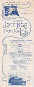
Magazine (sub-item) - Newsletter, The Victoria Missions to Seamen, Jottings From Our Log, Issue 15 - June Quarter 1909, 1909
... victorian seamen's mission...melbourne misson to seamen...jottings from our log...lhlg...rope...flying angel...seagull...advertising...port melbourne...williamstown...sailors' home...australian wharf...seamen's institute...sailors' rest...services...concerts...events...socials...deaths...captain press...w.h.c. darvall...motor boat...geelong...boat builder...manx king...glenlui...dovenby...marion woodside...ainsdale...robert reid...bagatelle board...billiard table...sir wilmot fawkes...lady fawkes...book bags...woolies...michaelmas...1906...quarterly...ladies harbour...The Mission holds a photograph of this publication being packed in calico by the members of the 'Ladies Harbour Lights Guild' for distribution to branches and supporters. Published for some 30 years by the Victorian Missions to Seamen issued to supporters the series contributes to the history of the organisation. ...The earliest example of this newsletter published two to three times per year issued by the Mission to Seamen and LHLG. The Mission holds a photograph of this publication being packed in calico by the members of the 'Ladies Harbour Lights Guild' for distribution to branches and supporters.Published for some 30 years by the Victorian Missions to Seamen issued to supporters the series contributes to the history of the organisation. It is a key cross reference supplying many details and dates of Chaplain and LHLG activities in both Melbourne, Port Phillip and other States where Missions were gradually established and information not able to be included in Annual Reports. It is also a source of images.newsletter, victorian seamen's mission, melbourne misson to seamen, jottings from our log, lhlg, rope, flying angel, seagull, advertising, port melbourne, williamstown, sailors' home, australian wharf, seamen's institute, sailors' rest, services, concerts, events, socials, deaths, captain press, w.h.c. darvall, motor boat, geelong, boat builder, manx king, glenlui, dovenby, marion woodside, ainsdale, robert reid, bagatelle board, billiard table, sir wilmot fawkes, lady fawkes, book bags, woolies, michaelmas, 1906, quarterly, ladies harbour lights guild, captain strickland -
 Mission to Seafarers Victoria
Magazine (sub-item) - Newsletter, The Victoria Missions to Seamen, Jottings From Our Log, Number 4 - Michaelmas 1906, 1906
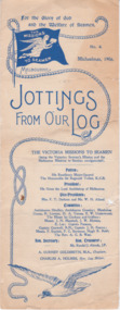
... victorian seamen's mission...melbourne misson to seamen...jottings from our log...lhlg...rope...flying angel...seagull...advertising...port melbourne...williamstown...sailors' home...australian wharf...seamen's institute...sailors' rest...services...concerts...events...socials...deaths...captain press...w.h.c. darvall...motor boat...geelong...boat builder...manx king...glenlui...dovenby...marion woodside...ainsdale...robert reid...bagatelle board...billiard table...sir wilmot fawkes...lady fawkes...book bags...woolies...michaelmas...1906...ladies harbour...It is also a source of images. newsletter victorian seamen's mission melbourne misson to seamen jottings from our log lhlg rope flying angel seagull advertising port melbourne williamstown sailors' home australian wharf seamen's institute sailors' rest services concerts events socials deaths captain press w.h.c. darvall motor boat geelong boat builder manx king glenlui dovenby marion woodside ainsdale robert reid bagatelle board billiard table sir wilmot fawkes lady fawkes book bags woolies michaelmas 1906 ladies harbour lights guild captain strickland quarterly patron sir reginald talbot president archbishop of melbourne vice president f.t. derham w.h. allard frederick thomas derham (1844-1922) william henry allard (1860-1927) committee membres archdeacon hindley archdeacon crossley william george hindley owen thomas lloyd crossley mary danne mrs e.w. underwood captain parsons captain creswell captain j.h.fearon ethel augusta godfrey hugh r. reid charles blunt ditty bags donachy and sons rope manufacturers robur tea mackenzie mustard excelsior baking powder admiral wilmot fawkes bobs games Long two folds newsletter printed in blue ink on paper with design of a rope, the flying angel mission flag and a seagull. ...Content: WHC Darvall's death Mission's motor boat New central mission Institute Williamstown Rest condition LHLG and their work Thanks Opening hours AdvertisingPublished for some 30 years by the Victorian Missions to Seamen issued to supporters the series contributes to the history of the organisation. It is a key cross reference supplying many details and dates of Chaplain and LHLG activities in both Melbourne, Port Phillip and other States where Missions were gradually established and information not able to be included in Annual Reports. It is also a source of images.newsletter, victorian seamen's mission, melbourne misson to seamen, jottings from our log, lhlg, rope, flying angel, seagull, advertising, port melbourne, williamstown, sailors' home, australian wharf, seamen's institute, sailors' rest, services, concerts, events, socials, deaths, captain press, w.h.c. darvall, motor boat, geelong, boat builder, manx king, glenlui, dovenby, marion woodside, ainsdale, robert reid, bagatelle board, billiard table, sir wilmot fawkes, lady fawkes, book bags, woolies, michaelmas, 1906, ladies harbour lights guild, captain strickland, quarterly, patron, sir reginald talbot, president, archbishop of melbourne, vice president, f.t. derham, w.h. allard, frederick thomas derham (1844-1922), william henry allard (1860-1927), committee membres, archdeacon hindley, archdeacon crossley, william george hindley, owen thomas lloyd crossley, mary danne, mrs e.w. underwood, captain parsons, captain creswell, captain j.h.fearon, ethel augusta godfrey, hugh r. reid, charles blunt, ditty bags, donachy and sons, rope manufacturers, robur tea, mackenzie mustard, excelsior baking powder, admiral wilmot fawkes, bobs, games -
 Mission to Seafarers Victoria
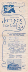
Magazine (sub-item) - Newsletter, The Victoria Missions to Seamen, Jottings From Our Log, Issue 14 - Easter 1909, 1909
... victorian seamen's mission...melbourne misson to seamen...jottings from our log...lhlg...rope...flying angel...seagull...advertising...port melbourne...williamstown...sailors' home...australian wharf...seamen's institute...sailors' rest...services...concerts...events...socials...deaths...captain press...w.h.c. darvall...motor boat...geelong...boat builder...manx king...glenlui...dovenby...marion woodside...ainsdale...robert reid...bagatelle board...billiard table...sir wilmot fawkes...lady fawkes...book bags...woolies...michaelmas...1906...quarterly...ladies harbour...The Mission holds a photograph of this publication being packed in calico by the members of the 'Ladies Harbour Lights Guild' for distribution to branches and supporters. Published for some 30 years by the Victorian Missions to Seamen issued to supporters the series contributes to the history of the organisation. ...The earliest example of this newsletter published two to three times per year issued by the Mission to Seamen and LHLG. The Mission holds a photograph of this publication being packed in calico by the members of the 'Ladies Harbour Lights Guild' for distribution to branches and supporters.Published for some 30 years by the Victorian Missions to Seamen issued to supporters the series contributes to the history of the organisation. It is a key cross reference supplying many details and dates of Chaplain and LHLG activities in both Melbourne, Port Phillip and other States where Missions were gradually established and information not able to be included in Annual Reports. It is also a source of images.newsletter, victorian seamen's mission, melbourne misson to seamen, jottings from our log, lhlg, rope, flying angel, seagull, advertising, port melbourne, williamstown, sailors' home, australian wharf, seamen's institute, sailors' rest, services, concerts, events, socials, deaths, captain press, w.h.c. darvall, motor boat, geelong, boat builder, manx king, glenlui, dovenby, marion woodside, ainsdale, robert reid, bagatelle board, billiard table, sir wilmot fawkes, lady fawkes, book bags, woolies, michaelmas, 1906, quarterly, ladies harbour lights guild, captain strickland, pulpit, mr haire -
 Mission to Seafarers Victoria
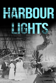
Film - Documentary, Wind and Sky Productions, Harbour Lights, 2019-2020
... A special thanks to The women of the Ladies Harbour Lights Guild 1906 to 1961 Produced in collaboration with The Mission to Seafarers Victoria Created with the support of The Victorian Government Licensing This film has been released under a Creative Commons BY-NC-ND 4.0 International license Acknowledgement of country Project production and development took place on the lands of the Kulin nation. ...A special thanks to The women of the Ladies Harbour Lights Guild 1906 to 1961 Produced in collaboration with The Mission to Seafarers Victoria Created with the support of The Victorian Government Licensing This film has been released under a Creative Commons BY-NC-ND 4.0 International license Acknowledgement of country Project production and development took place on the lands of the Kulin nation. ...Synopsis: “In WW1 Melbourne a pioneering network of women at the Mission to Seafarers called the Ladies Harbour Lights Guild supported sailors who risked their lives at sea. The documentary “Harbour Lights” tells the remarkable story of the Ladies Harbour Lights Guild and the lives of seafarers in early 20th century Melbourne. It focuses on Melbourne’s iconic Mission to Seafarers building, its connection to the Great War and to a unique community of ships crew and volunteers. Featuring Melbourne historians, commentators, archivists and architects and rare footage and images of sailing and social life in and around the ports of Melbourne, this film will inform and connect audiences young and old.” Commissioned by Victorian Government The movie was produced in collaboration with the Mission to Seafarers Victoria. It was directed by Jary Nemo and written and produced by Lucinda Horrocks and Jary Nemo with executive producers Sue Dight and Gordon MacMillan. The film features: Jill Garner Kate Darian-Smith Chris McConville Janet Miller (curator) Gordon MacMillan (former seafarer and board committee member) Narrated by Sharon Turley. Music by Richard Chew (professor of the Arts Academy in Ballarat) The film was presented at several festival in Australia and abroad in 2020-2021. Credits: Narrator Sharon Turley Featuring (in order of appearance) Dr Chris McConville, Gordon MacMillan, Janet Miller, Professor Kate Darian-Smith and Jill Garner With Raul S Gantalao Jr, Escoto Lemuel, Ben Schroeder, Cinda Manins And Ian Fletcher, Yuan Jia, Uma Kothari, Gordon Lansley, William Reed and Cheka Samaranayake Directed by Jary Nemo Written and Produced by Lucinda Horrocks and Jary Nemo Music by Richard Chew Executive Producers Sue Dight and Gordon MacMillan Research advisors Geraldine Brault, Maria Culka, Professor Kate Darian-Smith, Ros Fletcher, Professor Uma Kothari, Dr Barbara Lemon, Catherine McLay, Dr Chris McConville, Janet Miller, Rick Mitchell, Duncan ‘John’ Perryman, Dr Annette Sheill and Peter Taylor Archival photographs, music and footage courtesy of Australian Red Cross Society, Central Highlands Libraries, Internet Archive, National Film and Sound Archive, National Library of Australia, Mackarness Family Personal Archives, Mission to Seafarers Victoria, Public Record Office Victoria, State Library of Victoria and US National Archives Music Harbour Lights. Music by Richard Chew. Westering. Music by Richard Chew. Twilight (Crépuscule) by Jules Massenet. Performed by Amelita Galli-Curci. I Love You So, Waltz from The Merry Widow by Franz Lehár. Performed by Elise Stephenson and Harry Macdonough with Orchestra. Harbour Lights 2. Music by Richard Chew. If I Could Fly by Walking Hearts featuring Jennifer Holm. Courtesy of Epidemic Sound. With thanks to Peter Barrow, Sarah Bartak, Lin Bender AM, Patty Braumueller, Csilla Csongvay, Emer Diviney, Moira Drew, Ian Fletcher, Ajith Jayasuriya, Ben Jones, Patience Jones, Cinda Manins, Madeleine Martiniello, Georgia Melville, Elisabeth Moglia, Tara Oldfield, Lyn Pasquier, Nigel Porteous, Rev’d Onofre (Inni) Punay, Dr Rosalie Triolo, Ben Schroeder, David Simpson, Cheka Samaranayake, Daria Wray, the Helen Macpherson Smith Trust and KPMG. A special thanks to The women of the Ladies Harbour Lights Guild 1906 to 1961 Produced in collaboration with The Mission to Seafarers Victoria Created with the support of The Victorian Government Licensing This film has been released under a Creative Commons BY-NC-ND 4.0 International license Acknowledgement of country Project production and development took place on the lands of the Kulin nation. We acknowledge Traditional Owners and pay our respects to Elders past, present and future. Production company A Wind & Sky Production Copyright with © Wind & Sky Productions MMXIX The film was launched on Wednesday 26th February 2020 at the Mission. Speech by Veterans Affairs. Amongst the guests were current and former volunteers (Maria Culka, Gordon MacMillan, Elisabeth Moglia), curators (Georgia Melville, Jay Miller, Geraldine Brault)18mn documentary mixed of photographs from teh collection and interviews about the Ladies Harbour Lights Guild work during WWIladies harbour lights guild, documentary, jay miller, janet miller, geraldine brault, lucinda horrocks, gordon macmillan, jary nemo, kate darian-smith, jill garner, chris mcconville, sharon turley, richard chew, footage, archive -
 Mission to Seafarers Victoria
Plaque - Memorial Plaque, Amy Neville Brown (1882-1974), 1976
... (from diaries written by her and her sister Beatrice during 1909-1913 and held at the Glen Eira Historical Society, Amy tells she attends “kirk” with Miss Godfrey about once a month and each time they go to the “Institute” afterwards.) 1918 - 1922 sees Amy as “Schools secretary” LHLG. 1933 - Miss A N Brown becomes Honorary Secretary of the LHLG. 1946 – LHLG becomes “Harbour Lights Guild”. 1949 – Dora Simpson is president of HLG & Amy Brown is Honorary Secretary. 1957 – Amy retires as Honorary Secretary of the HLG. Other interests: 1933 - Amy founded the Victorian...(from diaries written by her and her sister Beatrice during 1909-1913 and held at the Glen Eira Historical Society, Amy tells she attends “kirk” with Miss Godfrey about once a month and each time they go to the “Institute” afterwards.) 1918 - 1922 sees Amy as “Schools secretary” LHLG. 1933 - Miss A N Brown becomes Honorary Secretary of the LHLG. 1946 – LHLG becomes “Harbour Lights Guild”. 1949 – Dora Simpson is president of HLG & Amy Brown is Honorary Secretary. 1957 – Amy retires as Honorary Secretary of the HLG. Other interests: 1933 - Amy founded the Victorian ...Amy Neville Brown (1882-1974) was a longlife member of the Mission to Seafarers ladies' Committees: 1910 - Amy is first mentioned in our records as LHLG branch secretary for Elsternwick. (from diaries written by her and her sister Beatrice during 1909-1913 and held at the Glen Eira Historical Society, Amy tells she attends “kirk” with Miss Godfrey about once a month and each time they go to the “Institute” afterwards.) 1918 - 1922 sees Amy as “Schools secretary” LHLG. 1933 - Miss A N Brown becomes Honorary Secretary of the LHLG. 1946 – LHLG becomes “Harbour Lights Guild”. 1949 – Dora Simpson is president of HLG & Amy Brown is Honorary Secretary. 1957 – Amy retires as Honorary Secretary of the HLG. Other interests: 1933 - Amy founded the Victorian Aboriginal Group along with Valentine Alexa Leeper (1900-2001). She acted as Hon. Sec. to the VAG for 40 years until its winding up in 1971 8 boxes of papers related to their activities are held at the SLV under Amy’s name (with Val Leeper). 1950 - Amy was a member of the YWCA 1963 – she was president of the Agnes Benson Auxiliary of the YWCA. Amy’s parents were Andrew Howden Brown & Catherine Marianne (Kitty) Wight. She had 2 brothers: Charles John Brown, Edward Byam Brown & 3 sisters: Jean Constance Brown (1884-1973), Catherine Philpott Brown (1886-1980), Grace *Beatrice Brown (1889-1984) who was also a member of the Mission's ladies' committee. None of 4 sisters married, they lived all their lives in Elsternwick. Edward Byam Brown was an academic at Melbourne University rising to become Ass. Prof. of Electrical Engineering by the 1950s. He married Vera Scantlebury in 1926 – they had 2 children. Amy’s maternal grandparents were Edward Byam Wight and Catherine Philpott. Both arrived in Melbourne in the early 1840s. Edward Wight is included on Thomas Chuck’s collage of early Victorian pioneers. Anne Jackson has written a short biography of Catherine’s brother, William Philpott, which includes a paragraph on Edward Wight. Catherine’s youngest son, Neville Wight, became a solicitor living at Woodend. He married Grace Rutherford – Mrs Neville Wight was a member of our Executive Committee from 1929 to 1933. Neville Wight’s obituary states that “he served his articles with … the firm of Moule & Seddon”. The principal of this firm was W H Moule, well known judge and cricketer. His son, also W H Moule, was Honorary Secretary of MtSV Executive Committee for 20 years until his retirement in 1958. was a member of the Harbour Lights Guild ( Honorary General Secretary in the 30s) then the Flying Angel League. She passed away in September 1974. A protege and friend of the Godfreys and Ina Higgins she actively assisted in setting up school branches of LHLG and eventually became a leading member in the 1930s.The window made by Tony Hall along with this plaque were dedicated in 1976. Amy Neville Brown had a lifelong association with the Mission and other philanthropic and social causes. Small plaque mounted on wooded board.In memory of Amy Brown For her lifetime of devoted service to the Mission 26th September, 1974amy brown, plaque, memorial, flying angel club, lhlg, amy neville brown (1882-1974), victoria aboriginal group (1933-1971), vag, val leeper, valentina alexa leeper (1900-2001) -
 Mission to Seafarers Victoria
Plaque - Memorial Plaque, Rev. Alfred Gurney Goldsmith, 1925
... After a public meeting organised by the Victorian Mission to Seamen he entered into an amalgamation forging formal links with London, enabling a continuation of the services to seafarers, first commenced in 1857. Goldsmith also conceived the formation of an auxiliary, the Ladies Harbour ...Reverend Alfred Gurney Goldsmith has two memorial plaques at the Mission to Seafarers Victoria. One in the the Mission's club room and this one in the Chapel of Saint Peter. He served as Senior Chaplain from 1905 to 1924 through a considerable period of upheaval including the building of two Missions between 1906 and 1917. For more information see 0639 an invitation to the laying of the foundation stone, 0704 a photograph of Reverend Goldsmith and his wife as well as the Mission's annual report from 1925 or contact the curator.Rev'd Gurney Goldsmith arrived in Australia in 1905, an experienced missionary with the intention of establishing a branch of the London Mission to Seamen. After a public meeting organised by the Victorian Mission to Seamen he entered into an amalgamation forging formal links with London, enabling a continuation of the services to seafarers, first commenced in 1857. Goldsmith also conceived the formation of an auxiliary, the Ladies Harbour Lights Guild, which was to play a significant role in support of the Mission and seafarers.Long rectangular brass plaque mounted to brick wall.To the glory of God and in loving memory of Rev. Alfred Gurney Goldsmith M.A. Chaplain 1905 to 1924reverend alfred gurney goldsmith, brass, plaque, memorial, chapel, hong kong, kobe, melbourne, lhlg, seamen mission, mission to seafarers, mission to seamen, chaplain -
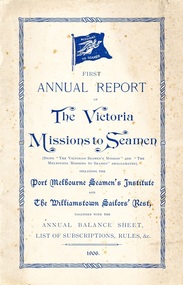 Mission to Seafarers Victoria
Administrative record (sub-series) - Annual Reports, Victorian Seamen's Mission, Annual Reports - Victorian Seamen's Mission, 1857 -1905
... Includes reports from the Committees, Chaplain, the Ladies Harbour Light Guild, donors and list of subscriptions and members rules which changed at various periods. See also comments above and description for missing issues and storage locations. From 1906, the Victorian...Includes reports from the Committees, Chaplain, the Ladies Harbour Light Guild, donors and list of subscriptions and members rules which changed at various periods. See also comments above and description for missing issues and storage locations. From 1906, the Victorian ...Victorian Seamen's MissionChronologicalannual-report, victoria-missions-to-seamen, victorian-seamens-mission, melbourne-missions-to-seamen, port-melbourne-seamens-institute, williamstown-sailors-rest, 1906, financial reports, members, rules for members, war memorial fund, administrative document-annual reportannual-report, victoria-missions-to-seamen, victorian-seamens-mission, melbourne-missions-to-seamen, port-melbourne-seamens-institute, williamstown-sailors-rest, 1906, financial reports, members, rules for members, war memorial fund, administrative document-annual report -
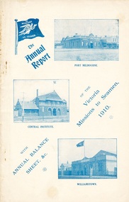 Mission to Seafarers Victoria
Administrative record (item) - Annual report, The Victoria Missions to Seamen, 1910 Annual Report of the Victoria Missions to Seamen, 1911
... Harbour Lights Guild. These reports provide documentation of the activities conducted by the Mission, as well recording the people involved. 1910 annual report Victorian seamen's mission williamstown sailors' rest port melbourne siddeley street central institute seamen's institute mission to seafarers melbourne administrative document-annual report written in pencil: MTS0235 (Front cover) A white booklet with blue printed text, the Missions to Seamen's logo and photographs of the Port Melbourne, Central Institute and Williamstown locations. ...The report was produced by and distributed to members, containing reports from the Committee, Chaplain, the Ladies Harbours Lights Guild, as well as a list of subscriptions and rules for the 1910 period. This copy is the first to feature images of all three main Mission venues established in Port Phillip pre WW1.Annual reports were published by the Mission to Seamen each year, and included reports from all seamen's missions and organisations in Victoria, as well as associated groups, such as the Ladies Harbour Lights Guild. These reports provide documentation of the activities conducted by the Mission, as well recording the people involved.written in pencil: MTS0235 (Front cover)1910, annual report, victorian seamen's mission, williamstown, sailors' rest, port melbourne, siddeley street, central institute, seamen's institute, mission to seafarers, melbourne, administrative document-annual report