Showing 797 items
matching bearing
-
 Wodonga & District Historical Society Inc
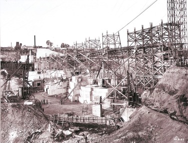
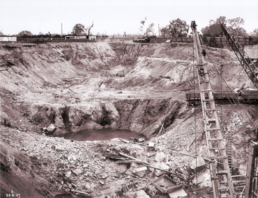
Album - Hume Reservoir Australia Album - Work proceeding inside the coffer dam (2), August 1927
This set of photos is from a leather bound album bearing the inscription "HUME RESERVOIR AUSTRALIA" plus 'The Rt. Hon. L. C. M. S. Amery, P. C., M .P.' all inscribed in gold. It was presented to The Rt. Hon. L. C. M. S. Amery, P. C., M. P, Secretary of State for Dominion Affairs on the occasion of his visit to the Hume Reservoir on 2nd November 1927. This album is of local and national significance as it documents the planning and development of the Hume Reservoir up to 1927. It was the largest water reservoir in the British Empire. The album records the pioneering engineering work that went into its construction.DEPARTMENT OF PUBLIC WORKS, N.S.W. RIVER MURRAY WATERS SCHEME. HUME RESERVOIR. 26. Work proceeding inside the coffer dam. This view was taken from the edge of the cut for the South Wing Wall foundations looking from the opposite direction to that of the preceding photograph, the curving downstream face of the main wall being seen beyond the steam navvy. This view shows the way in which the concrete paddocks are stepped and broken jointed vertically and horizontally. In the distance is the North Wing Wall and Power House stack beyond it. New South Wales, August 1927.hume reservoir australia, river murray waters scheme, hume reservoir construction -
 Wodonga & District Historical Society Inc
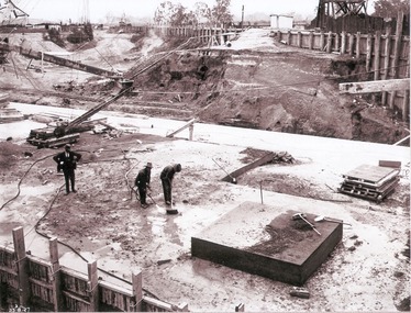
Album - Hume Reservoir Australia Album - Preparing a paddock for concrete. August 1927
This set of photos is from a leather bound album bearing the inscription "HUME RESERVOIR AUSTRALIA" plus 'The Rt. Hon. L. C. M. S. Amery, P. C., M .P.' all inscribed in gold. It was presented to The Rt. Hon. L. C. M. S. Amery, P. C., M. P, Secretary of State for Dominion Affairs on the occasion of his visit to the Hume Reservoir on 2nd November 1927. This album is of local and national significance as it documents the planning and development of the Hume Reservoir up to 1927. It was the largest water reservoir in the British Empire. The album records the pioneering engineering work that went into its construction.DEPARTMENT OF PUBLIC WORKS, N.S.W. RIVER MURRAY WATERS SCHEME. HUME RESERVOIR. 27. Preparing a Paddock for Concrete. Great care is taken in cleaning the surface of the concrete before placing the next layer. A hose applies a jet of water with a pressure of about 150 pounds to remove laitance and all dirt, which is swept off with brooms. (Laitance is the weak, milky or powdery layer of cement dust, lime and sand fines that appear on the surface of concrete. ) The square block of concrete in the foreground is poured at the same time as the concrete surrounding it and acts as a key for the next layer. Usually large granite “plums” or displacers weighing from 2 tons to 8 tons are used for this purpose and are placed in position by the cableway, but while the cableway is out of action the other method has been adopted. In this view may also be seen some of the timber piles and sheeting which form the inner side of the coffer dam. The outer side is formed of steel sheet piling. The space between the two lines of piles is 20 feet wide and is filled with earth after the steel and timber lines have been bound together by steel tie rods. New South Wales, August 1927.hume reservoir australia, river murray waters scheme, hume reservoir construction -
 Wodonga & District Historical Society Inc
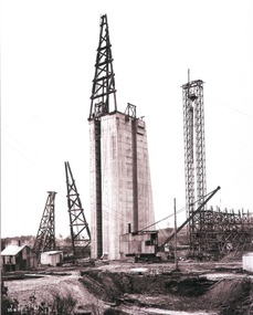
Album - Hume Reservoir Australia Album - Concrete pillar for tall tower, New South Wales, August 1927
This set of photos is from a leather bound album bearing the inscription "HUME RESERVOIR AUSTRALIA" plus 'The Rt. Hon. L. C. M. S. Amery, P. C., M .P.' all inscribed in gold. It was presented to The Rt. Hon. L. C. M. S. Amery, P. C., M. P, Secretary of State for Dominion Affairs on the occasion of his visit to the Hume Reservoir on 2nd November 1927. This album is of local and national significance as it documents the planning and development of the Hume Reservoir up to 1927. It was the largest water reservoir in the British Empire. The album records the pioneering engineering work that went into its construction.DEPARTMENT OF PUBLIC WORKS, N.S.W. RIVER MURRAY WATERS SCHEME. HUME RESERVOIR. 28. Concrete Pillar for Tail Tower. This shows the back and upstream side of the tower. The groove at the back is left for the reception of the concrete core wall of the earth embankment. The groove is being used at present as a hoist well, up and down which men and materials are conveyed in connection with the re-erection of the Tail Tower of the cableway. The pillar is 108 feet from the ground and is within 4 feet of its ultimate height. The foundation of this part at its deepest is 90 feet below the natural surface so that when the 80 feet tower and jury mast are in place the total height from foundation to top of mast will be about 300 feet. New South Wales, August 1927.hume reservoir australia, river murray waters scheme, hume reservoir construction -
 Wodonga & District Historical Society Inc
Album - Hume Reservoir Australia Album - View of concrete dam from top of tall tower pillar, August 1927
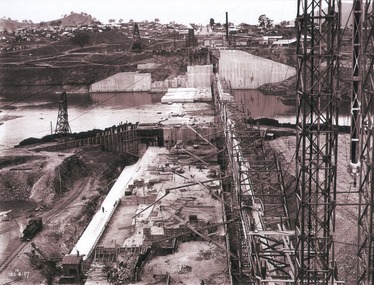
This set of photos is from a leather bound album bearing the inscription "HUME RESERVOIR AUSTRALIA" plus 'The Rt. Hon. L. C. M. S. Amery, P. C., M .P.' all inscribed in gold. It was presented to The Rt. Hon. L. C. M. S. Amery, P. C., M. P, Secretary of State for Dominion Affairs on the occasion of his visit to the Hume Reservoir on 2nd November 1927. This album is of local and national significance as it documents the planning and development of the Hume Reservoir up to 1927. It was the largest water reservoir in the British Empire. The album records the pioneering engineering work that went into its construction.DEPARTMENT OF PUBLIC WORKS, N.S.W. RIVER MURRAY WATERS SCHEME. HUME RESERVOIR. 29. View from Top of Tail Tower Pillar - Concrete Dam. This was taken from the top of the Tower described in the preceding photograph looking towards New South Wales. (WHS 00722) First is the part of the spillway being built inside the Coffer Dam, then over the Coffer Dam the submerged portion of the Spillway and outlet sections for the river diversion, beyond that the situation for the hydro-electric turbo passages bounded by the North Wing Wall. The gap may be seen in wing wall for the passage of the belt conveyor and half of the concrete mixer house behind. This gives a general view of the New South Wales Township. The Quarry is on the side of the hill showing up beyond the Township. New South Wales, August 1927.hume reservoir australia, river murray waters scheme, hume reservoir construction -
 Wodonga & District Historical Society Inc
Album - Hume Reservoir Australia Album - View of South Wing Wall Foundations from Top of Tail Tower Pillar, August 1927
This set of photos is from a leather bound album bearing the inscription "HUME RESERVOIR AUSTRALIA" plus 'The Rt. Hon. L. C. M. S. Amery, P. C., M .P.' all inscribed in gold. It was presented to The Rt. Hon. L. C. M. S. Amery, P. C., M. P, Secretary of State for Dominion Affairs on the occasion of his visit to the Hume Reservoir on 2nd November 1927. This album is of local and national significance as it documents the planning and development of the Hume Reservoir up to 1927. It was the largest water reservoir in the British Empire. The album records the pioneering engineering work that went into its construction.DEPARTMENT OF PUBLIC WORKS, N.S.W. RIVER MURRAY WATERS SCHEME. HUME RESERVOIR. 30. View from Top of Tail Tower Pillar - South Wing Wall Foundations. This photograph was taken at right angles to the preceding one, (WHS 00723) ooking downstream along the cut for the South Wing Wall foundation. The granite is at a greater depth here than elsewhere and the cut will be twice as deep before the foundations are cleared. New South Wales. August 1927.hume reservoir australia, river murray waters scheme, hume reservoir construction -
 Wodonga & District Historical Society Inc
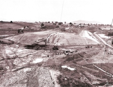
Album - Hume Reservoir Australia Album - Earth embankment on Victorian side from Top of Tail Tower Pillar, August 1927
This set of photos is from a leather bound album bearing the inscription "HUME RESERVOIR AUSTRALIA" plus 'The Rt. Hon. L. C. M. S. Amery, P. C., M .P.' all inscribed in gold. It was presented to The Rt. Hon. L. C. M. S. Amery, P. C., M. P, Secretary of State for Dominion Affairs on the occasion of his visit to the Hume Reservoir on 2nd November 1927. This album is of local and national significance as it documents the planning and development of the Hume Reservoir up to 1927. It was the largest water reservoir in the British Empire. The album records the pioneering engineering work that went into its construction.DEPARTMENT OF PUBLIC WORKS, N.S.W. RIVER MURRAY WATERS SCHEME. HUME RESERVOIR. 31. View from Top of Tail Tower Pillar - Earth Embankment, Victoria. This is a general view of the embankment which is being constructed by the Victorian Constructing Authority. The bank at its base is about 650 feet wide and it is about half its ultimate height. In the middle is the reinforced concrete core wall. At about the natural surface a tunnel for drainage and inspection purposes is built along the downstream side of the core wall but this cannot be seen. The Victorian workshops and township are located on the high ground beyond the embankment. The embankment curves round to the left at the side of the valley and will eventually block the gulley where the bushy tree stands. Access to one of the cuttings from which material is being got for the embankment is gained by means of this gulley at present. Part of another cutting may be seen on the right hand side at the back. August 1927.hume reservoir australia, river murray waters scheme, hume reservoir construction -
 Wodonga & District Historical Society Inc
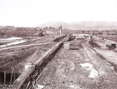
Album - Hume Reservoir Australia Album - Earth embankment, Victoria, August 1927
This set of photos is from a leather bound album bearing the inscription "HUME RESERVOIR AUSTRALIA" plus 'The Rt. Hon. L. C. M. S. Amery, P. C., M .P.' all inscribed in gold. It was presented to The Rt. Hon. L. C. M. S. Amery, P. C., M. P, Secretary of State for Dominion Affairs on the occasion of his visit to the Hume Reservoir on 2nd November 1927. This album is of local and national significance as it documents the planning and development of the Hume Reservoir up to 1927. It was the largest water reservoir in the British Empire. The album records the pioneering engineering work that went into its construction.DEPARTMENT OF PUBLIC WORKS, N.S.W. RIVER MURRAY WATERS SCHEME. HUME RESERVOIR. 32. Earth Embankment, Victoria. Looking down on the earth embankment and core wall. The earth is conveyed to the bank by rail, tipped out and then put in place by wheeled scoops, the horses and wheels treading and rolling the material into a very compact form while hoses play water on the mass to keep it moist. The concrete pillar with Tail Tower, and North Wing Wall, look very small in the distance. August 1927.hume reservoir australia, river murray waters scheme, hume reservoir construction -
 Wodonga & District Historical Society Inc
Album - Hume Reservoir Australia Album - Concrete Slabs on embankment, August 1927
This set of photos is from a leather bound album bearing the inscription "HUME RESERVOIR AUSTRALIA" plus 'The Rt. Hon. L. C. M. S. Amery, P. C., M .P.' all inscribed in gold. It was presented to The Rt. Hon. L. C. M. S. Amery, P. C., M. P, Secretary of State for Dominion Affairs on the occasion of his visit to the Hume Reservoir on 2nd November 1927. This album is of local and national significance as it documents the planning and development of the Hume Reservoir up to 1927. It was the largest water reservoir in the British Empire. The album records the pioneering engineering work that went into its construction.DEPARTMENT OF PUBLIC WORKS, N.S.W. RIVER MURRAY WATERS SCHEME. HUME RESERVOIR. 33. Concrete Slabs on Embankment. The upstream face of the embankment is being protected from the effects of wave action by concrete slabs 12 inches thick laid in squares in situ. The thrust at the toe of the bank is taken care of by a body of granite blocks and spalls. Victoria. August 1927.hume reservoir australia, river murray waters scheme, hume reservoir construction -
 Wodonga & District Historical Society Inc
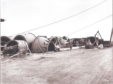
Album - Hume Reservoir Australia Album - Needle valves, August 1927
This set of photos is from a leather bound album bearing the inscription "HUME RESERVOIR AUSTRALIA" plus 'The Rt. Hon. L. C. M. S. Amery, P. C., M .P.' all inscribed in gold. It was presented to The Rt. Hon. L. C. M. S. Amery, P. C., M. P, Secretary of State for Dominion Affairs on the occasion of his visit to the Hume Reservoir on 2nd November 1927. This album is of local and national significance as it documents the planning and development of the Hume Reservoir up to 1927. It was the largest water reservoir in the British Empire. The album records the pioneering engineering work that went into its construction.DEPARTMENT OF PUBLIC WORKS, N.S.W. RIVER MURRAY WATERS SCHEME. HUME RESERVOIR. 34. Needle Valves. Some of the needle valves in parts stacked ready for removal by the cableway to their positions on the outlets. There are seven of these, 7 feet 6 inches in diameter. The heaviest single part weighs about 10 tons. New South Wales. August 1927. A needle valve is a type of valve which can be used to regulate flow of a substance, usually either gas or water, through an appliance or system. The unique feature of the value is the inclusion of a small plunger, with a shape akin to a needle.hume reservoir australia, river murray waters scheme, hume reservoir construction -
 Wodonga & District Historical Society Inc
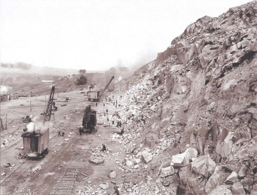
Album - Hume Reservoir Australia Album - View along the face of the quarry, August 1927
This set of photos is from a leather bound album bearing the inscription "HUME RESERVOIR AUSTRALIA" plus 'The Rt. Hon. L. C. M. S. Amery, P. C., M .P.' all inscribed in gold. It was presented to The Rt. Hon. L. C. M. S. Amery, P. C., M. P, Secretary of State for Dominion Affairs on the occasion of his visit to the Hume Reservoir on 2nd November 1927. This album is of local and national significance as it documents the planning and development of the Hume Reservoir up to 1927. It was the largest water reservoir in the British Empire. The album records the pioneering engineering work that went into its construction.DEPARTMENT OF PUBLIC WORKS, N.S.W. RIVER MURRAY WATERS SCHEME. HUME RESERVOIR. 35. Quarry. View along the face of the quarry. Granite is being quarried here for the concrete material. Blocks from 2-8 tons in weight are reserved for “plums”. Quantities of large size spalls are sent to Victoria for the toe of the embankment and other purposes but the greatest proportion of the stone is crushed at the quarry to 2½ inches gauge for concrete aggregate. Two steam navvies and two steam travelling cranes are at work on the face. New South Wales. August 1927.hume reservoir australia, river murray waters scheme, hume reservoir construction -
 Wodonga & District Historical Society Inc
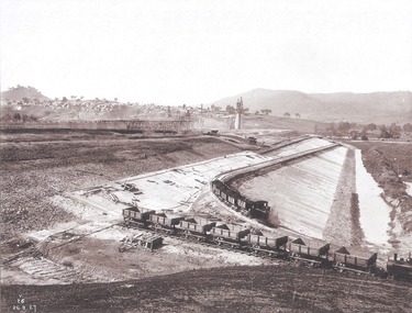
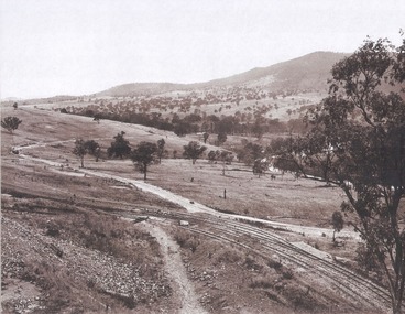
Album - Hume Reservoir Australia Album - Valley of the Murray to be crossed by the Bethanga Bridge 1927
This set of photos is from a leather bound album bearing the inscription "HUME RESERVOIR AUSTRALIA" plus 'The Rt. Hon. L. C. M. S. Amery, P. C., M .P.' all inscribed in gold. It was presented to The Rt. Hon. L. C. M. S. Amery, P. C., M. P, Secretary of State for Dominion Affairs on the occasion of his visit to the Hume Reservoir on 2nd November 1927. This album is of local and national significance as it documents the planning and development of the Hume Reservoir up to 1927. It was the largest water reservoir in the British Empire. The album records the pioneering engineering work that went into its construction.DEPARTMENT OF PUBLIC WORKS, N.S.W. RIVER MURRAY WATERS SCHEME. HUME RESERVOIR. 36. Valley of the Murray to be crossed by the Bethanga Bridge described in the next photograph. (WHS 00731) This view shows the marshalling sidings for trucks below the Quarry, New South Wales, and the branch line to the site of the bridge.hume reservoir australia, river murray waters scheme, hume reservoir construction -
 Wodonga & District Historical Society Inc
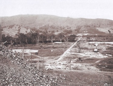
Album - Hume Reservoir Australia Album - Bethanga Bridge Site, August 1927
This set of photos is from a leather bound album bearing the inscription "HUME RESERVOIR AUSTRALIA" plus 'The Rt. Hon. L. C. M. S. Amery, P. C., M .P.' all inscribed in gold. It was presented to The Rt. Hon. L. C. M. S. Amery, P. C., M. P, Secretary of State for Dominion Affairs on the occasion of his visit to the Hume Reservoir on 2nd November 1927. This album is of local and national significance as it documents the planning and development of the Hume Reservoir up to 1927. It was the largest water reservoir in the British Empire. The album records the pioneering engineering work that went into its construction.DEPARTMENT OF PUBLIC WORKS, N.S.W. RIVER MURRAY WATERS SCHEME. HUME RESERVOIR. 37. Bethanga Bridge Site. A bridge is being built to cross the Reservoir to serve a large area of country which will be cut off from its natural outlets by the submergence of existing bridges when the Reservoir is in being. The site of the bridge is nearly a mile up the Murray from the Hume Reservoir Quarry. Its length will be approximately half a mile. There will be nine spans of 269 feet with steel truss girders resting on concrete pillars. Some of the pillars are founded on rock while others will rest on nests of reinforced concrete piles. The foundations and concrete piers are in the hands of the Victorian Constructing Authority and the superstructure in those of the New South Wales Authority. August 1927.hume reservoir australia, river murray waters scheme, hume reservoir construction -
 Wannon Water
Cast iron seal embossing press, Excello, Seal
Heywood Waterworks Trust was constituted on 20 November 1962 upon application by Councillors of the Shire of Portland to construct, manage and maintain the works for the supply of water to the township of Heywood. The Trust was abolished on 1 July 1984 under the Water and Sewerage (Restructuring) Act 1983 when it amalgamated with the Heywood Sewerage Authority to form Heywood Water BoardA cast iron seal press, . This was used by Heywood Waterworks Trust to emboss agreements and official documents. Die is still attached to the press. It reads: Heywood Waterworks Trust 1963Small metal machine painted black and mounted onto a black rubber base. Two dies are attached with the seal of Heywood Waterworks Trust. Paper is placed between the dies, the handle depressed and the seal embossed on the paper under pressure as a blind (inkless) embossing. The seal consists of two circles with the wording "Heywood Waterworks Trust".Heywood Waterworks Trust 1963/ Excello / Reg Trade Mark/ Seal Press/ Pat NO 420419/Size No 2/Inscription on rubber base: "EXCELLO SEAL PRESS" / REGD TRADE MARK / 1. PATENT ROLLER BEARING HANDLE PAT. NO. 420419 / 2. DURABLE PLASTIC COUNTER / 3. RUBBER DESK PROTECTOR / STANDARD RUBBER TYPE CO. LTD. / TOKYO JAPAN"heywood, public administration, water supply, amalgamations -
 Flagstaff Hill Maritime Museum and Village
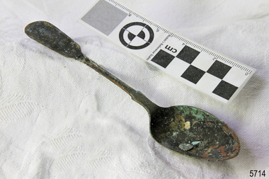
Domestic object - Spoon, c. 1878
This tea spoon is from the wreck of the LOCH ARD, a Loch Line ship of 1,693 tons which sailed from Gravesend, London, on 2 March 1878 with 17 passengers and a crew of 36 under Captain George Gibbs. “The intention was to discharge cargo in Melbourne, before returning to London via the Horn with wool and wheat”. Instead, on 1 June 1878, after 90 days at sea, she struck the sandstone cliffs of Mutton Bird Island on the south west coast of Victoria, and sank with the loss of 52 lives and all her cargo. The manifest of the LOCH ARD listed an array of manufactured goods and bulk metals being exported to the Colony of Victoria, with a declared value of £53,700. (202 bills of lading show an actual invoice value of £68, 456, with insurance underwriting to £30,000 of all cargo). Included in the manifest is the item of “Tin hardware & cutlery £7,530”. This teaspoon is one of 482 similar items of electro-plated cutlery from the LOCH ARD site, comprising spoons and forks of various sizes but all sharing the same general shape or design and metallic composition. 49 of these pieces display a legible makers’ mark — the initials “W” and “P” placed within a raised diamond outline, which is in turn contained within a sunken crown shape — identifying the manufacturer as William Page & Co of Birmingham. An electroplater’s makers’ marks, unlike sterling silver hallmarks, are not consistent identifiers of quality or date and place of manufacture. A similar line of five impressions was usually made to impress the consumer with an implication of industry standards, but what each one actually signified was not regulated and so they varied according to the whim of the individual foundry. In this case, the maker’s marks are often obscured by sedimentary accretion or removed by corrosion after a century of submersion in the ocean. However sufficient detail has survived to indicate that these samples of electro-plated cutlery probably originated from the same consignment in the LOCH ARD’s cargo. The following descriptions of maker’s marks are drawn from 255 tea spoons, 125 dessert spoons, and 99 table forks. These marks are clearly visible in 66 instances, while the same sequence of general outlines, or depression shapes, is discernible in another 166 examples. 1. A recessed Crown containing a raised Diamond outline and the initials “W” and “P” (the recognised trademark of William Page & Co) 2. An impressed Ellipse containing a raised, pivoted, Triangle in its lower part and bearing a Resurrection Cross on its upper section (a possible dissenting church symbol reflecting religious affiliation); OR a rounded Square impression containing a raised, ‘lazy’, letter “B” (possibly mimicking sterling silver hallmark signifying city of manufacture i.e. Birmingham) 3. An impressed rounded Square filled with a raised Maltese Cross (the base metal composite of nickel silver was also known as ‘German silver’ after its Berlin inventors in 1823) 4. A recessed Circle containing a Crab or Scarab Beetle image; OR a recessed Circle containing a rotated ‘fleur de lys’ or ‘fasces’ design 5. A depressed Diamond shape enclosing a large raised letter “R” and a small raised letter “D” (mimicking the U.K. Patent Office stamp which abbreviated the term ‘registered’ to “RD”, but also included date and class of patent) Suggested trade names for William Page & Co’s particular blend of brass plating are ‘roman silver’ or ‘silverite’. This copper alloy polishes to a lustrous gold when new, discolouring to a murky grey with greenish hue when neglected. HISTORY OF THE LOCH ARD The LOCH ARD belonged to the famous Loch Line which sailed many ships from England to Australia. Built in Glasgow by Barclay, Curdle and Co. in 1873, the LOCH ARD was a three-masted square rigged iron sailing ship. The ship measured 262ft 7" (79.87m) in length, 38ft (11.58m) in width, 23ft (7m) in depth and had a gross tonnage of 1693 tons. The LOCH ARD's main mast measured a massive 150ft (45.7m) in height. LOCH ARD made three trips to Australia and one trip to Calcutta before its final voyage. LOCH ARD left England on March 2, 1878, under the command of Captain Gibbs, a newly married, 29 year old. She was bound for Melbourne with a crew of 37, plus 17 passengers and a load of cargo. The general cargo reflected the affluence of Melbourne at the time. On board were straw hats, umbrella, perfumes, clay pipes, pianos, clocks, confectionary, linen and candles, as well as a heavier load of railway irons, cement, lead and copper. There were items included that intended for display in the Melbourne International Exhibition in 1880. The voyage to Port Phillip was long but uneventful. At 3am on June 1, 1878, Captain Gibbs was expecting to see land and the passengers were becoming excited as they prepared to view their new homeland in the early morning. But LOCH ARD was running into a fog which greatly reduced visibility. Captain Gibbs was becoming anxious as there was no sign of land or the Cape Otway lighthouse. At 4am the fog lifted. A man aloft announced that he could see breakers. The sheer cliffs of Victoria's west coast came into view, and Captain Gibbs realised that the ship was much closer to them than expected. He ordered as much sail to be set as time would permit and then attempted to steer the vessel out to sea. On coming head on into the wind, the ship lost momentum, the sails fell limp and LOCH ARD's bow swung back. Gibbs then ordered the anchors to be released in an attempt to hold its position. The anchors sank some 50 fathoms - but did not hold. By this time LOCH ARD was among the breakers and the tall cliffs of Mutton Bird Island rose behind the ship. Just half a mile from the coast, the ship's bow was suddenly pulled around by the anchor. The captain tried to tack out to sea, but the ship struck a reef at the base of Mutton Bird Island, near Port Campbell. Waves broke over the ship and the top deck was loosened from the hull. The masts and rigging came crashing down knocking passengers and crew overboard. When a lifeboat was finally launched, it crashed into the side of LOCH ARD and capsized. Tom Pearce, who had launched the boat, managed to cling to its overturned hull and shelter beneath it. He drifted out to sea and then on the flood tide came into what is now known as LOCH ARD Gorge. He swam to shore, bruised and dazed, and found a cave in which to shelter. Some of the crew stayed below deck to shelter from the falling rigging but drowned when the ship slipped off the reef into deeper water. Eva Carmichael had raced onto deck to find out what was happening only to be confronted by towering cliffs looming above the stricken ship. In all the chaos, Captain Gibbs grabbed Eva and said, "If you are saved Eva, let my dear wife know that I died like a sailor". That was the last Eva Carmichael saw of the captain. She was swept off the ship by a huge wave. Eva saw Tom Pearce on a small rocky beach and yelled to attract his attention. He dived in and swam to the exhausted woman and dragged her to shore. He took her to the cave and broke open case of brandy which had washed up on the beach. He opened a bottle to revive the unconscious woman. A few hours later Tom scaled a cliff in search of help. He followed hoof prints and came by chance upon two men from nearby Glenample Station three and a half miles away. In a state of exhaustion, he told the men of the tragedy. Tom returned to the gorge while the two men rode back to the station to get help. By the time they reached LOCH ARD Gorge, it was cold and dark. The two shipwreck survivors were taken to Glenample Station to recover. Eva stayed at the station for six weeks before returning to Ireland, this time by steamship. In Melbourne, Tom Pearce received a hero's welcome. He was presented with the first gold medal of the Royal Humane Society of Victoria and a £1000 cheque from the Victorian Government. Concerts were performed to honour the young man's bravery and to raise money for those who lost family in the LOCH ARD disaster. Of the 54 crew members and passengers on board, only two survived: the apprentice, Tom Pearce and the young woman passenger, Eva Carmichael, who lost all of her family in the tragedy. Ten days after the LOCH ARD tragedy, salvage rights to the wreck were sold at auction for £2,120. Cargo valued at £3,000 was salvaged and placed on the beach, but most washed back into the sea when another storm developed. The wreck of LOCH ARD still lies at the base of Mutton Bird Island. Much of the cargo has now been salvaged and some was washed up into what is now known as LOCH ARD Gorge. Cargo and artefacts have also been illegally salvaged over many years before protective legislation was introduced. One of the most unlikely pieces of cargo to have survived the shipwreck was a Minton porcelain peacock - one of only seven in the world. The peacock was destined for the Melbourne International Exhibition in 1880. It had been well packed, which gave it adequate protection during the violent storm. Today, the Minton peacock can be seen at the Flagstaff Hill Maritime Museum in Warrnambool. From Australia's most dramatic shipwreck it has now become Australia's most valuable shipwreck artefact and is one of very few 'objects' on the Victorian State Heritage Register The LOCH ARD shipwreck is of State significance – Victorian Heritage Register S 417. Flagstaff Hill’s collection of artefacts from LOCH ARD is significant for being one of the largest collections of artefacts from this shipwreck in Victoria. It is significant for its association with the shipwreck, which is on the Victorian Heritage Register (VHR S417). The collection is significant because of the relationship between the objects, as together they have a high potential to interpret the story of the LOCH ARD. The LOCH ARD collection is archaeologically significant as the remains of a large international passenger and cargo ship. The LOCH ARD collection is historically significant for representing aspects of Victoria’s shipping history and its potential to interpret sub-theme 1.5 of Victoria’s Framework of Historical Themes (living with natural processes). The collection is also historically significant for its association with the LOCH ARD, which was one of the worst and best known shipwrecks in Victoria’s history. Unrestored tea spoon from the wreck of the LOCH ARD. The spoon design has a flattened fiddle-back handle, with a thin stem or shank, flared collar, and elongated bowl. The spoons metallic composition is a thin layer of brass alloy which has partially corroded back to a nickel-silver base metal. Only 10% of original electroplate seems to be remaining, with another 10% of spoon surface bearing some verdigris. Appears to be a small piece of silver plate from another source stuck to bowl. One of five makers marks is discernible (3) Maltese Cross.flagstaff hill maritime museum, shipwreck coast, great ocean road, loch line, loch ard, mutton bird island, loch ard gorge, electroplated cutlery, loch ard shipwreck, nickel silver, william page & co, birmingham, brass plating, makers marks -
 Bendigo Military Museum
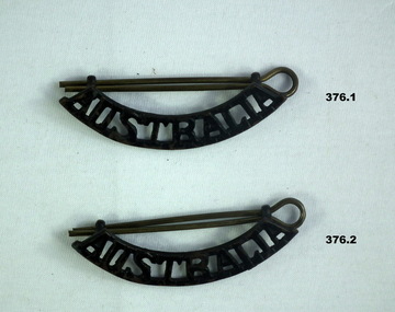
Uniform - BADGES, C.1939 - 45
Badges belonged to Thomas Henry ISER V24933 and VX102660 2nd AIF. Refer Cat No 383.2 for his service history..1,.2) Badge, "AUSTRALIA" shoulder, blackend brass with brass split pin. .3,.4) Crown shaped metal badge signifying rank of major with brass back plate holding maroon velvet, plush fabric, dark bronze with split pins. .5,.6 & 7) Badge, rank "pip" officer with brass split pins. central circle with three acorns surrounded by circle bearing motto, a third circle has a chain and this whole section is squared off with stylised leaves or feathers making a pointed edge"TRIA JUNGTA IN UNO" motto surrounding acorns in reliefnumismatics-badges-military, army uniform -
 Flagstaff Hill Maritime Museum and Village
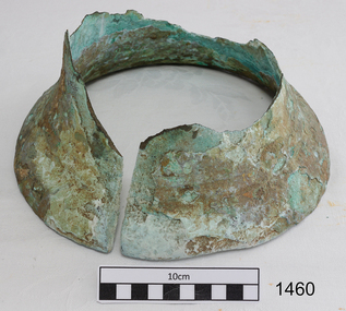
Bell, Before 1837
This remnant of a ships bell was recovered from the wreck site of the CHILDREN by Flagstaff Hill Divers on 1 October 1973. (Diving identification number S.M24/10-73, Accession number 24). The artefact had lain in the ocean off Childers Cove since the vessel’s disastrous sinking there on 15 January 1839. Other similarly high value metallic objects raised from the site, and now in the Flagstaff Hill collection, are the ship’s signal cannon (1963), and the ship’s anchor (1974). A ship’s bell was normally struck by the lookout at the foreward part of a vessel, following orders (“Strike the bell”) from the officer of the watch at the helm, or as a warning signal of danger ahead. Its main function was to keep the crew aware of time. Each 24 hour period was divided into 4 hour work-shifts, or watches, and each of these was divided into 8 half hours, or glasses (each half hour being determined by the time it took between each turn of the ship’s hourglass). The six watches were the first watch from 8pm to midnight, the second or middle watch from midnight to 4am, the third or morning watch from 4 to 8am, the fourth of forenoon watch from 8am to midday, the fifth or noon watch from midday to 4pm, and the sixth or dog watch from 4 to 8pm. Within each watch the first half hour would end with one bell, the second with two bells, the third with three bells, and so on until their work-shift ended with the ringing of eight bells. The CHILDREN left Launceston on 11 January 1839 and immediately struck heavy weather. By the evening of 15 January Captain Browne had been continuously on duty for 4 days and needed sleep, his First Mate (T. Gay) was incapacitated with seasickness, and the task of command was given to the Second Mate (W. Wentworth). At two bells into the first watch, or 9 o’clock that night, the captain went below. Two hours later, at six bells into the first watch, or 11 o’clock that night, the lookout cried “Breakers close ahead”. Within a minute the ship struck the rocks at the entrance of Childers Cove. Within twenty minutes the huge seas had taken her stern, three masts and much of her weatherside, leaving survivors clinging to the forecastle. Within two hours the wreck had completely disappeared. If anyone could have rung the bell by then, it would have been to strike two bells into the middle-watch, or one o’clock on the morning of 16 January. An 1859 Victorian Register of Wrecks from 1835 to 1858 remarks the CHILDREN “Ran ashore through an error in the reckoning and a bad lookout [and] Became a total wreck”. 22 passengers and crew survived the tragedy, but 16 lives were lost, including the captain and second mate, and 8 children. The shipwreck of the CHILDREN is of State significance ― Victorian Heritage Register S116A part of a brass ship’s bell, recovered from the wreck of the CHILDREN. The upper part, or dome of the bell, has corroded away, leaving the lower portion, or mouth of the bell, largely intact. However this lower surviving portion has been severed vertically with a clear (saw?) cut, leaving a regular 1cm gap down one side of the bell. It is an evocative relic, attractively aged on the seafloor, bearing layers of aqua-marine verdigris and white limestone accretion on a dull bronze surface. There is no visible ship’s name on the bell. flagstaff hill, warrnambool, shipwrecked coast, flagstaff hill maritime museum, maritime museum, shipwreck coast, flagstaff hill maritime village, great ocean road, the children, bell, ships bell, childers cove, henty brothers, james henty & co, sea-watches, nautical time, james henty & co, bell from the children -
 Flagstaff Hill Maritime Museum and Village
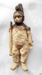
Leisure object - Toy Soldier, circa 1878
The toy soldier is a relic from the shipwreck of the LOCH ARD in 1878. It has a companion piece in the Flagstaff Hill collection. The toy soldier is unpainted, but the style of uniform, and the weapons carried (a musket and a basket-handled cutlass), indicate it is a representation of the Napoleonic Wars period from the beginning of the nineteenth century. Mass-produced toy soldiers made of cast metal (lead or tin) became popular during the 1800s. Heyde of Germany manufactured silhouette-shaped ‘flats’ early in the century; then Mignot of France released three-dimensional ‘solids’; and later (1893) Britain of England made ‘hollow cast’ figures. These innovations were designed to make sets of toy soldiers more affordable for middle and lower-class children, extending the market beyond the intricately made and hand-crafted replicas that were the preserve of the rich in the eighteenth century. Wooden military figures, specially carved and unpainted ones, were therefore not particularly common at the time when the LOCH ARD went down on Victoria’s southwest coast. Mignot was the first to sell unpainted soldiers, leaving their customers to fill in the colours according to their own patriotic preferences. If a similar attitude is assumed for the two virtually identical figures in the Flagstaff Hill collection, it is possible they were part of a new set intended for sale, rather than part of a passenger’s existing collection. A similarly light composite material of sawdust, glue and linseed oil (press-moulded onto a metal frame) was used by the German firm O & M Hausler to create toy soldiers, but this type of modelling was not commercialised until after 1912. The first heat-moulded plastic toy soldiers did not become available until after 1945.The toy soldier represents a 19th century child's interest in military history. The item is one of two toy soldiers recovered from the Loch Ard that are in Flagstaff Hill's collection. The shipwreck of the Loch Ard is of significance for Victoria and is registered on the Victorian Heritage Register ( S 417). Flagstaff Hill has a varied collection of artefacts from Loch Ard and its collection is significant for being one of the largest accumulation of artefacts from this notable Victorian shipwreck of which the subject items are a small part. The collections objects give us a snapshot of how we can interpret the story of this tragic event. The collection is also archaeologically significant as it represents aspects of Victoria's shipping history that allows us to interpret Victoria's social and historical themes of the time. Through is associated with the worst and best-known shipwreck in Victoria's history.An unpainted replica or toy soldier, presented in a Napoleonic Wars era uniform. The moulded figure is in a standing posture and is bearing a musket at the slope-arms position, with a sabre or cutlass slung behind. It wears a plumed helmet, short-fronted coat with longer buttoned tails at the back, button-fastened bib-front trousers, a pair of crossed bandoliers, and tasselled shoulder epaulettes. The figure is a creamy colour with red-brown stains on the head and shoulder. There is a hole in the end of the musket. The model is detailed and sharp. It was recovered from the wreck of the Loch Ard.Cataloguing numbers: “6599” on the rear of the left trouser leg “PWO 2308” on the sole of the left boot, (partially obscuring “R122” written in biro) “2218” on the sole of the right boot.flagstaff hill, warrnambool, loch ard, flagstaff hill maritime museum, shipwreck coast, flagstaff hill maritime village, great ocean road, loch line, napoleonic uniform, toy soldier, replica soldier -
 Ballarat Tramway Museum
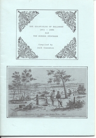
Book, Jack Cranston, "The Goldfields of Ballarat 1851 - 1886 and The Eureka Stockade", 1970's?
Book - "The Goldfields of Ballarat 1851 - 1886 and The Eureka Stockade", compiled by Jack Cranston. Comprises blue cover with 28 pages folded and stapled inside and fold out map glued to the inside of the rear cover, "Map of Ballaarat and Sebastopol" showing the various leads and gold bearing reefs of the goldfields. Also shows the location of Eureka Stockade and Sovereign Hill. Published for the Sovereign Hill Association, 1970's? Looks at the Goldfields, sources of Nuggets, mining population and statistics, the Miners Rebellion and the Stockade. Has numerous illustrations and copies of posters.trams, tramways, gold, eureka, sovereign hill -
 University of Melbourne, Burnley Campus Archives
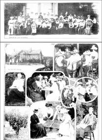
Newspaper - Newspaper Cutting, The Leader, The School of Horticulture, 1899
Photocopy of article in "The Leader," February 18, 1899 about the introduction of female students. Includes illustrations from 'The School of Horticulture, Burnley' (1) View of the Grounds. (2) Instructing a Class. (3) A Group of Students. The Principal, Mr C. Bogue Luffman. Original of article without photographs. Another photocopy version, same date - Page of photographs: Group of Ladies, The Principal's House, A Lesson in Budding, Mrs Luffmann, Specimen Dwarf Apple Tree in Full-Bearing, Sorting Prunes, Mr C Luffmann Principalthe leader, female students, charles bogue luffman, school of hortriculture, mrs luffmann, mr c luffmann, principal, prunes, budding, outside classes, principal's residence, apple tree -
 Glenelg Shire Council Cultural Collection
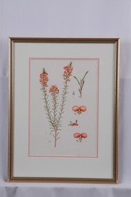
Drawing - Drawing, Botanical, Collin Elwyn Woolcock, Dillwynia Sericea (Showy Parrot-Pea), n.d
Part of 'Woolcock Gallery Collection' Exhibited CEMA 1989.View of flowering plant with stem and flower details. On left is a view of stem with three smaller stems bearing long, thin green leaves and ending in clusters of pea flowers (apricot in colour). On right (t-b): stem detail with leaves; end view of leaf depicting curve; top view of flower; side view; rear view. All views are numbered in pencil and typed numbers on paper affixed to surface of paper. Mounted in double matt (white on apricot), framed under glass in wooden frame with gold detail.Front: CEW (signature, lower left in image) (maroon pencil). Dillwynia sericea (lower right) (pencil). Back: 39 (upper let) (pen)collin woolcock, botanical, woolcock collection, cema, botanical drawings -
 Dandenong/Cranbourne RSL Sub Branch
Large Book, "The Changing of the Guard"
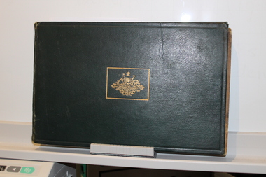
Large Green Leather covered book with Gold Australian Coat of Arms on front.Reproduced from Official and other photographs of the two World Wars. Published under the auspices of the Board of Management of the Australian War Memorial. Contains Dedication - To the men and women of the Empire who in every hour of danger , face the storm … who in their willing sacrifice are bearing the brunt of a struggle for the peace and security of all peoples. Faint stamp "Maurice Parker" inside front cover top left. -
![Cumberland Creek, near Point Sturt / [by] Nicholas Caire, circa 1876](/media/collectors/550653872162f11fb04854aa/items/57834713d0cdd1176c71111b/item-media/57834799d0cdd1176c71e113/item-fit-380x285.jpg) Kew Historical Society Inc
Kew Historical Society IncPhotograph, Anglo-Australasian Photographic Company, Cumberland Creek, near Point Sturt, c. 1876
Nicholas Caire was born on Guernsey in the Channel Islands in 1837. He arrived in Adelaide with his parents in about 1860. In 1867, following photographic journeys in Gippsland, he opened a studio in Adelaide. From 1870 to 1876 he lived and worked in Talbot in Central Victoria. In 1876 he purchased T. F. Chuck's studios in the Royal Arcade Melbourne. In 1885, following the introduction of dry plate photography, he began a series of landscape series, which were commercially successful. As a photographer, he travelled extensively through Victoria, photographing places few of his contemporaries had previously seen. He died in 1918. Reference: Jack Cato, 'Caire, Nicholas John (1837–1918)', Australian Dictionary of Biography.An original, rare photograph from the series 'Views of Victoria: General Series' by the photographer, Nicholas Caire (1837-1918). The 60 photographs that comprise the series were issued c. 1876 and reinforced a neo-Romantic view of the Australian landscape to which a growing nationalist movement would respond. Nicholas Caire was active as a photographer in Australia from 1858 until his death in 1918. His vision of the Australian bush and pioneer life had a counterpart in the works of Henry Lawson and other nationalist poets, authors and painters.‘Cumberland Creek, near Point Sturt’ : Views of Victoria (General Series) No.59 : Albumen silver photograph | Photo on card with Title and Description on reverse | Mounted 24 x 30 cm; Photo 12 x 17 cm.On Reverse: ‘The Cumberland Creek is so named from the close resemblance it bears to the place bearing that name in the mother country. The present illustration represents the precipices and hills which surround the Cumberland Creek. The soil around the hills is mostly sandstone rubble, hence the only vegetation identical with the spot is the inevitable sword grass and salt scrub, which frequently exist where no other vegetation can be found.’nicholas caire (1837-1918), landscape photography -
 Vision Australia
Document - Text, Merle Reid Album, 1985
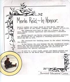
In March 1985, Merle Reid past away. She had worked for RVIB at Burwood since 1963, first as a cleaner but later as a laundry supervisor and childcare assistant. Encouraged by Matron Dunnell, she began her teacher qualifications and went on to become a teacher at the school. With her positive outlook, she became a firm favourite with children and staff alike, and to honour her impact, a proposal was made for a new outdoor playground was made bearing her name.Album of images and text as a tribute to Merle Reidrvib burwood school, merle reid -
 Ballarat Tramway Museum
Administrative record, State Electricity Commission of Victoria (SECV), "Some notes pertaining to tramway conference, Ballarat", 4/1954
Set of notes prepared before the 1954 conference by the Ballarat office. Notes actions on the 1952 and 1953 conferences, rail profile survey, bitumen paving, painting of tram, blinds, removal of sun blinds, lights fitted to trams, brake blocks - hardness and allowable wear, side bearing clearances, castings, track and depot workshop hours, costs, trolley wheels, lubrication products used, alterations to Maximum traction tramcars, and failure of pony wheel axles.Yields information and demonstrates SECV meeting notes prepared prior to a joint meeting.Four foolscap sheets - carbon copy.secv, ballarat, trams, tramways, minutes, sec, tramcar equipment, maintenance, trackwork, trolley wheels, motors, maximum traction, employees -
 Orbost & District Historical Society
branding iron, late 19th -mid 20th century
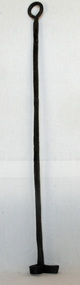
Branding irons are used to print a burn an identifying marker on the hide of horses or cattle so that they may be later identified if they become lost or escape from their pasture. The irons were typically forged by blacksmiths using a toolset that included hammers, anvils and chisels. The branding irons were used by heating the end bearing the owner’s initials to a very high temperature in a furnace, and then burnishing it against the skin of the cow. Brands were registered with state governments as unique marks. This allowed for a state registry to be maintained. This is an example of an implement used locally in the livestock industry.A branding iron with letter R on circular end. Handle loop is oval shaped. It has been painted blue to half way.branding-iron rural-industry -
 Orbost & District Historical Society
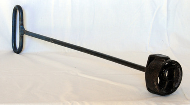
branding iron
Branding irons are used to print a burn an identifying marker on the hide of horses or cattle so that they may be later identified if they become lost or escape from their pasture. The irons were typically forged by blacksmiths using a toolset that included hammers, anvils and chisels. The branding irons were used by heating the end bearing the owner’s initials to a very high temperature in a furnace, and then burnishing it against the skin of the cow. Brands were registered with state governments as unique marks. This allowed for a state registry to be maintained. This item is an example of a common implement used in the livestock industry in Orbodt.A long-handled branding iron with an S or 2 on the end. There is a loop at the top for hanging.branding-iron rural livestock-industry -
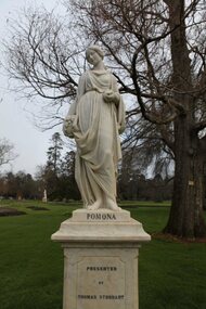 City of Ballarat
Artwork, other - Public Artwork, B. Raggi, Pomona, Circa 1880
Thomas Stoddart (1828 - 1905) bought 12 white marble statues during a visit to Italy. Stoddart arranged for them to be shipped to Victoria and placed on pedestals of Sicilian marble and on bases of Victorian granite. These statues were unveiled in the gardens on Queen Victoria's birthday, 24th May, 1884. His intention was for the statues to adorn and add interest to the gardens. The Roman Goddess of fruit trees, Pomona, is shown holding a vessel and fruit to illustrate her care and cultivation of trees and the bearing of fruitful abundance.The artwork is of historic and aesthetic significance to the people of BallaratWhite marble figure of a woman holding a vessel and fruitPomona by B. Raggipomona, stoddard, botanic gardens -
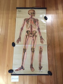 Ambulance Victoria Museum
Chart, medical, human body, the skeleton, J.Teck
Rectangular chart made from printed and coated paper on a fabric base. The chart is mounted at either end on timber batons using small metal tacks. The upper baton is moulded while the lower baton is circular in cross-section. Both batons are stained black.Two screwed metal eyelets have been attached to the upper baton for use in hanging the chart. A short length of redcotton tape is attached to the mid-point of the upper baton with a metal tack. the tape is used to secure the chart after it has been rolled up.A printed paper label is attached to the reverse of the chart bearing the words 'THE SKELETON'. The logo of the St John Ambulance Association and the words 'ST JOHN'S GATE, LONDON E.C.1' are printed on the botton edge of the chart (LHS). The artists name 'J. Teck' is printed just above. A second, unknown logo is printed on the top LH corner of the chart. Much of it has flaked off so it is not possible to read it.medical chart, human body, j.teck -
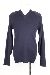 Warrnambool RSL Sub Branch
Jumper, Calcoup Knitwear, C 2015
This jumper is part of a General Purpose Uniform issued by the Australian Airforce to Bernard Farley during service. This uniform type was developed in 2014 and replaced camouflage as the uniform worn during general base duties and in non-warlike environments. Although a camouflage pattern, this design is not intended for use as camouflage. This woolen jumper was presumably a winter addition to the GPU.This item has social significance, as an item of uniform worn by Warrnambool RSL community member and Secretary (2019), Bernard Farley during service with the Australian Airforce. The item is a representative example of current Airforce General Purpose Uniform and is in excellent condition. As a set, the uniform has aesthetic significance in it’s design, incorporating GPU uniform design from the Army alongside the colours and motifs of the Australian Airforce. Navy blue ribbed knitted jumper with stitched navy cotton elbow patches, rectangular in shape. Similar rectangular shaped patches on the left and right shoulder, bearing two epaulettes, stiched at one end and fastened with velcro and the other. The left shoulder carries an Airforce embroidered patch at the top of the arm. Arm cuffs have external seam for approximately 100 mm from the end, indicating that the jumper may have been worn with cuffs folded over. Synthetic strip of black fabric on the interior collar behind a cream coloured label.Label on interior of collar reads: “CALCOUP KNITWEAR/291083/ 06/01 / 8405/661468799 / SIZE: 115cm-125cm/SERVICE No........./ NAME........../MACHINE WASHABLE GENTLE CYCLE/Fasten shoulder straps before/washing. Warm machine wash,/inside out on medium cycle./Do not bleach./Warm rinse. Normal spin./Doi not tumble dry./Dry in shade. Warm iron./ Dry Cleanable A/80% Wool 20% Nylon”camouflage, general purpose uniform, airforce, uniform, australian defence force -
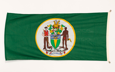 Bayside Gallery - Bayside City Council Art & Heritage Collection
Flag, Evan Evans, City of Brighton flag
The coat of arms on this flag were granted by the British College of Arms in 1970 and represented Brighton City Council's "growing awareness of the importance of formality and correct symbolism in local government". It replaced the council's crest of a pier and yachting scene and was used as council's seal, emblem on its flag and letterhead. The new Coat of Arms, drawn up by the College of Arms in England, depicts the progression from a seaside gardening community to a modern residential city. The prominent forms are on the shield-like coat of arms include waves and a Lymphad (a ship, symbolic of the sea); a market gardener; an aboriginal man; two horns of plenty with abundant fruit and vegetables (the wealth and plenty) and Elster Creek (now Elster Canal). It is underscored by the motto "By their fruits, ye shall know them". Brighton was first incorporated as a borough on 18 January 1859, it became a town on 18 March 1887 and was proclaimed a city on 12 March 1919.Green flag with circular City of Brighton Coat of Arms in the centre. The central circle is white with a yellow edge, with a polychrome coat of arms featuring: the crest which is two cornucopia with fruits and vegetables, above sits a seagull. The mantle above the helmet is in green and gold. The shield is also green and gold with a lymphad (ship) and blue and white waves. The market gardener, holding a hoe, and Aboriginal figure, bearing a boomerang, support the shield and stand upon the compartment which is soil with a representation of Elster creek. A ribbon below contains the motto in blue 'FRUCTU NOSCITUR'.flag, brighton, city of brighton, coat of arms, college of arms, market gardener, aboriginal, elster creek, lymphad, fructu noscitur, armorial bearings, heraldry, cornucopia, by their fruits ye shall know them, motto