Showing 4180 items
matching creek street
-
 Orbost & District Historical Society
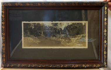
framed black and white photograph, C1920
... Orbost & District Historical Society Ruskin Street Orbost ...Boggy Creek Bridge was built in 1916 as part of the Bairnsdale to Orbost extension to the main Gippsland Railway, and is situated in the middle of the township of Nowa Nowa, crossing a steep-sided and well-timbered creek-valley. This section of the line closed in 1987. This item is a pictorial record of the Boggy Creek railway bridge on the East Gippsland line. This bridge plays a major part in the identity and history of the town of Nowa Nowa, since Boggy Creek’s steep sided valley divides the township into two components.A black / white photograph of a bridge across a river in the bush. It is under glass in a brown wooden frame which has gold decorated edges. There appears to be a man sitting on rocks in the right front foreground.on front of photograph - "Nowa Nowa Creek, Gippsland, Victoria, Sears, Copyright"boggy-creek-nowa-nowa east-gippsland-railway bridge-rail -
 Orbost & District Historical Society
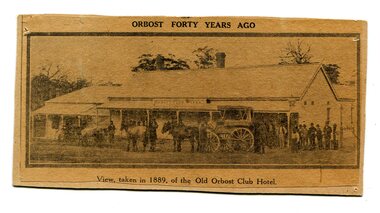
newspaper clipping, Orbost Forty Years Ago, 1929?
The first hotel built in Orbost was the Club in 1885 an old wooden place on the corner built for J. A. Petersen of the Mitchell Hotel Bairnsdale, with the licence in the name of Mr Thomas Maguire (stepson of Petersen). In June 1889 there was a rush to Mackenzie River, about 28 miles from Orbost, on Twelve Mile Creek. An estimated 80 men rushed the ground, but yields were patchy and large numbers eventually left. They were coming and going almost daily.The Club Hotel was the first hotel built in Orbost and remains a significant building in the town. It was an important hub for the township with many whole town meetings held there.A yellowed black / white newspaper clipping of a photograph of people with a horse and cart outside a one-storey hotel building. It is glued onto a piece of cardboard.Caption at bottom - "View taken in 1889 of the Old Orbost Club Hotel"orbost-club-hotel -
 Orbost & District Historical Society
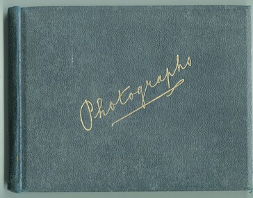
photograph album, James, Harry, 1900 - 1910
Photographs in this album are : forest,creek; Burns Cutting; river with bridge; Tony in his boat (spare print); Murrungowar and three of Conran.Henry James (1860-1932) was a well-known identity in the Orbost district.He was a stock agent and auctioneer who helped to establish the seed bean industry in Orbost. He was the second secretary of the Snowy River Shipping Co. as well as a shire councillor and prominent member of MUIOOF.a fabric covered book with gold print - "Photographs" on front cover. It contains an assortment of photographs.inside front cover - "Photographs taken by Mr Harry James about 1900-10"james-harry photography-orbost-conran-murrungowar -
 Orbost & District Historical Society
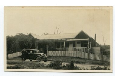
black and white photograph, 1920s -1930s
The Cabbage Tree Creek township was originally established to support the booming timber industry of the mid 20th century. Five timber mills worked full time supporting the families that were drawn to the area's wealth of natural resources. The settlement of Cabbage Tree Creek is located on the Princes Highway, 27 km east of Orbost in East Gippsland. The first white settler arrived in the valley in 1887 cutting a dray track from Marlo to the south-west. Several families cleared the alluvial flats, growing maize, peas and beans and raising pigs, cattle and sheep. Later the farmers milked cows, sending cream to Orbost. In the late 1890s, small quantities of alluvial gold were found in the creek. A school commenced classes in 1913, but enrolment was small and at times the school operated part time with several other small schools in the area. The school building served as a hall for the district. From the 1920s the Cabbage Tree Hotel catered to drivers on the improved Princes Highway. (info. from Victorian Places)This is a pictorial record of Cabbage Tree, East Gippsland in the late 20th century. It shows a building that no longer exists.A small black / white photograph of a single storey timber building. On a sign below the roof is "Cabbage Tree Hotel". The hotel is surrounded by a wooden picket fence. A man and woman are standing on either side of a motor car parked on the roadway in front of the building.on back - on label - Cabbage Tree Hotelcabbage-tree-hotel -
 Ringwood and District Historical Society
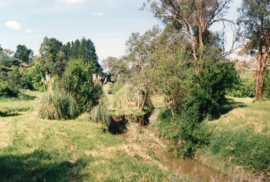
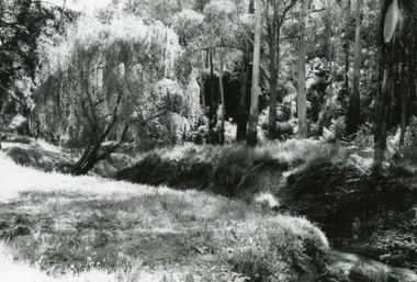
Photograph, Mullum Mullum Creek on 29th Oct 1989, north bank 100m west of Harrison Street, Unknown date
Digital photograph -
 Ringwood and District Historical Society
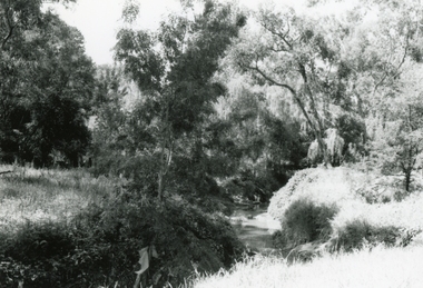
Photograph, Mullum Mullum Creek on 29th Oct 1989, corner of New and Nelson Streets, Unknown date
Digital photograph -
 Ringwood and District Historical Society
Photograph, Mullum Mullum Creek on 29th Oct 1989, south bank near end of Margaret Street, 1989
Digital photograph -
 Ringwood and District Historical Society
Photograph, Mullum Mullum Creek, at the end of George Street on 10th September 1989, 1989
Digital photograph -
 Ringwood and District Historical Society
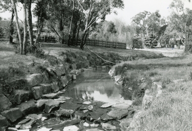
Photograph, Mullum Mullum Creek on south side about half-way between Ringwood Street and Acadia Street on 10th September 1989, 1989
Digital photograph -
 Ringwood and District Historical Society
Photograph, Mullum Mullum Creek near New and Nelson Streets corner, looking upstream on 29th October 1989, 1989
Digital photograph -
 Ringwood and District Historical Society
Photograph, Mullum Mullum Creek near New and Nelson Streets corner, downstream, on 29th October 1989, 1989
Digital photograph -
 Ringwood and District Historical Society
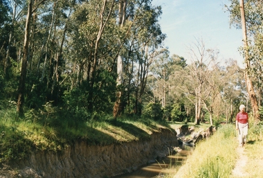
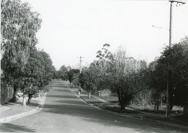
Photograph, Bardia Street, Ringwood at the Mullum Mullum Creek end on 10 September 1989
Digital photograph -
 Ringwood and District Historical Society
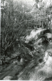
Photograph, Mullum Mullum Creek near end of Bardia Street, Ringwood on 10 September 1989
Digital photograph -
 Warrnambool and District Historical Society Inc.
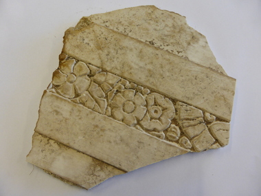
Buildings- Decoration, Plaster fragment from Criterion Hotel, Circa late 19th century
The Criterion Hotel was located on the western side of Kepler Street near the corner of Lava Street. John Tate of Woodford was the first licensee of the Criterion Hotel in 1873. The Humm family and the McGennan families were licensees for a considerable amount of time in the late 19th and 20th centuries. It was one of the last venues in the town to host live music. The last publican, John Palmer remembered it as a workers pub popular with local truckies and football clubs, in particular, Bushfield, Russell’s Creek and South Rovers. The Criterion closed in 2008 with the aim of turning it into office space but it was burnt beyond repair in 2010 and the remains were demolished in 2013.The Criterion Hotel was one of the earliest and longest licensed hotels in Warrnambool. As such it has local historical significance. The original building was an impressive landmark and the hotel itself has significant social importanceWhite plaster fragment with floral pattern enclosed within two plain borders. It is roughly five sided but edges are broken.criterion hotel, history of warrnambool, warrnambool hotels -
 Warrnambool and District Historical Society Inc.
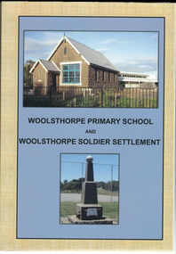
Book, Woolsthorpe Primary School and Woolsthorpe Soldier Settlement
History of the Woolsthorpe Primary School and Woolsthorpe Soldier SettlementThis is a soft-cover book with a blue and buff- coloured front cover featuring photographs of the Woolsthorpe Primary School and the Woolsthorpe War Memorial. The back cover has photographs of the R.S.L. Badge and the Woolsthorpe Primary School. It has 160 pages. non-fictionHistory of the Woolsthorpe Primary School and Woolsthorpe Soldier Settlementwarrnambool, woolsthorpe, soldier settlement -
 Warrnambool and District Historical Society Inc.
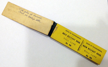
Certificate - Ticket Book, Main Belfast Road Toll, 2s 6d, 1860s
The Shire of Warrnambool operated toll gates from 1866 to 1869 as a means of revenue rai sing for road construction. There were three toll gate locations – on the main Belfast (Port Fairy) Road at Dennington Bridge, on the Woodford Road at Russells Creek and on the Geelong Road at the Allansford Bridge. The toll gates were unpopular and unprofitable for the lessees as travellers were able to avoid the tax by skirting around the gates. They had toll houses besides the gates. The printers of these tickets, Fairfax and Laurie were the lessees at the time of the Warrnambool Examiner newspaper. This paper, founded by Richard Osburne and John Wilkinson, and published with some gaps from 1851 to 1880, is a key source today of Warrnambool’s history at that time. These toll gates tickets are significant because:- 1. They date back to the 1860s and were only issued from 1866 to 1869. 2. They are the only artefacts we hold of the time when toll gates were operating in our local district 3. They are the best example of how the Shire of Warrnambool in its early history raised revenue for road building and maintenance This is a book of toll gate tickets for sale at the Main Belfast (Port Fairy) Road Toll Gate. The tickets (about 50) are yellow and in duplicate with provision to detach the outer ticket for the purchaser to keep. The tickets (two shillings and sixpence) are bound with an adhesive tape and the cover is mottled in pattern (brown and blue). There are also four loose tickets in blue (3 shillings). Back Cover: ‘136’ Tickets in book: ‘Shire of Warrnambool, Main Belfast Road, Toll Gate 2s 6d., Fairfax and Laurie, Printers’ Loose tickets: ‘Shire of Warrnambool, Main Belfast Road, Toll Gate, 3s.’ shire of warrnambool, toll gates -
 Warrnambool and District Historical Society Inc.
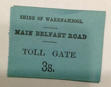
Document - Main Belfast Road Toll Gate Ticket Collection, 1860s
The Shire of Warrnambool operated toll gates from 1866 to 1869 as a means of raising revenue for road construction. There were three toll gate locations – on the main Belfast (Port Fairy) Road at Dennington Bridge, on the Woodford Road at Russells Creek and on the Geelong Road at the Allansford Bridge. The toll gates were unpopular and unprofitable for the lessees as travellers were able to avoid the tax by skirting around the gates. They had toll houses besides the tollgates. The printers of these tickets, William Fairfax and Henry Laurie, were the lessees at the time of the Warrnambool Examiner newspaper. This paper, founded by Richard Osburne and John Wilkinson, and published with some gaps from 1851 to 1880, is a key source today of Warrnambool’s history at the time. These toll gate tickets are significant because:- 1. They date back to the 1860s and were only issued from 1866 to 1869 2. They are the only artefacts we hold of the time when toll gates were operating in our local district 3. They are the best example of how the Shire of Warrnambool in its early history raised revenue for road building and maintenance. These are eleven toll gate tickets, ten for the Belfast (Port Fairy) Road toll gate and one for the Woodford Road toll gate. One is mounted on a Swintons store label (6 pence) and four are mounted on cardboard (2 shillings, sixpence, and two shillings and sixpence) and six are loose (three shillings, two shillings and sixpence and threepence). The Belfast Road tickets are yellow, green, blue and cream and the Woodford Road one is white. All have black printing. There is also an undated newspaper cutting with information on the toll gate tickets. Belfast Tickets: Shire of Warrnambool, Main Belfast Road, Toll Gate and the price Woodford Road: Shire of Warrnambool, Woodford Road, Toll Gate, 1s 6d Six of the eleven tickets also have ‘Fairfax and Laurie, Printers’ The sixpence ticket on card has the name R P Christian in ink written on the back of the card. shire of warrnambool, toll gates, r p christian, woodford road, main belfast road, swintons pty ltd -
 Warrnambool and District Historical Society Inc.
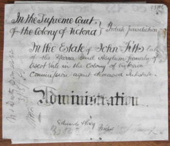
Document - John Fitts Letters of Administration 1879, 1879
No information has been found on the Commission Agent John Fitts except that he died at the Yarra Bend Asylum at the age of 51 and was formerly a resident of Ascot Vale, a suburb of Melbourne. His estate was valued at £600. Yarra Bend Asylum, near the junction of the Yarra River and the Merri Creek was the first institution for the mentally ill in Victoria and operated from 1848 to 1925. Tait collection: item 5 of 62This document is only of interest in that it came from the former legal offices of Mackay Taylor in Kepler Street, Warrnambool. It originally came from Thomas Goodall, a legal clerk in the office of the lawyer Ernest Chambers who passed it on to George Mackay, the lawyer in the forerunner firm of Mackay Taylor where it remained until the firm of Mackay Taylor ceased to exist and the buildings were cleaned out. This is a piece of parchment paper with printed black lines and handwritten material in black ink. There is a fold at the bottom of the document with a seal of the Supreme Court of the Colony of Victoria attached by a green ribbon. The document is slightly discoloured but is otherwise in good condition. ‘In the Supreme Court of the Colony of Victoria, Probate jurisdiction, In the Estate of John Fitts, late of the Yarra Bend Asylum, formerly of Ascot Vale in the Colony of Victoria, commission agent, deceased intestate, Administration, Edwards and Perry, Proctors’yarra bend asylum, john fitts, warrnambool -
 Warrnambool and District Historical Society Inc.
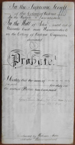
Document - John Gould Probate 1891, 1891
This 1891 document contains the information on the Will and Probate of John Gould, an engineer from Russells Creek. No information has been found on John Gould except that he died in October 1890 at the age of 67. The solicitor, William Ardlie was a well-known Warrnambool lawyer, commencing a practice in 1865 and continuing well into the 20th century making him at the time one of the longest-serving lawyers in the British Empire. Tait collection: item 10 of 62This document is of interest in that it includes information on a resident of Russells Creek in the Warrnambool area, and also the lawyer concerned is William Ardlie, one of the best-known identities in Warrnambool in the late 19th and early 20th centuries.This is an 1891 piece of parchment folded in half to give four pages of written material. This material is handwritten in black ink. A seal of the Supreme Court of the Colony of Victoria is attached with a green ribbon. The document is somewhat discoloured. ‘In the Supreme Court of the Colony of Victoria in the probate jurisdiction in the Will of John Gould, late of Russells Creek near Warrnambool in the Colony of Victoria, Engineer, deceased, Probate. I certify that there is no duty payable. J. F. Poole, Officer under Section 96, Act 1060, June 23rd 1891. Extracted by William Ardlie, Solicitor, Warrnambool’. john gould, william ardlie, warrnambool -
 Warrnambool and District Historical Society Inc.
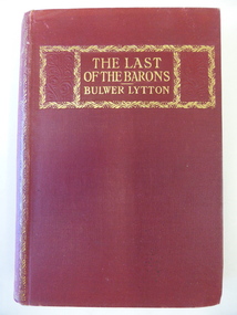
Book, The last of the Barons, 1843
The Davidson brothers, James and John, were pioneer settlers in the Warrnambool district, with John establishing th property of Rosebrook in Woodford and James establishing the homestead of Woodend in West Warrnambool. Another brother William was an early storekeeper in Woolsthorpe. He died in 1904 and may be the W. Davidson who was the recipient of this book. The Midgleys came to the Yangery Creek area in 1852 and established the property of Yangery Grange. Mrs Midgley presumably belonged to one of these families from pioneer times. Ethel Davidson would be a descendant of one of the Davidson families but there were several women with this name born in the 19th century though one born to a William Davidson in 1887 may be the later owner of this book. This book is of interest because of its connection to members of the Davidson families – pioneer settlers in the Warrnambool area.This is a hard cover book of 461 pages. The cover is dark red with some ornamental borders and gold lettering. The book has two black and white full page illustrations, with the first one protected with tissue paper. The inscriptions are handwritten in blue and black ink. ‘To W. Davidson from Mrs Midgley’ ‘Ethel M. Davidson’ william davidson, ethel davidson, history of warrnambool. -
 Warrnambool and District Historical Society Inc.
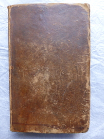
Book, The history of ancient Greece pub 1812, 1812
This book has the signature of Joseph Ware of Minjah, Caramut, Victoria. Joseph Ware came, with his parents, from England to Van Diemen’s Land (Tasmania) in 1822. With his brother, Jeremiah, he came to the Port Phillip Colony (Victoria) in 1838 and settled in the Colac area (Wooriwyrite and Koort-Koort-Nong stations). With his brothers or alone Joseph then held the runs of Minjah, Mustons Creek (Barwidgee), Sinclair West and Springburn. Joseph Ware was a highly successful pastoralist, breeding sheep, cattle and horses and importing Shorthorn cattle. Ware was connected with Minjah from 1845 to his death in 1895. The homestead at Minjah which still stands today was built by Joseph Ware in 1870. This book is of interest because of its antiquarian nature. But it is far more important because it was once the property of Joseph Ware. He and his brothers were most influential pastoralists in South Western Victoria in the 19th century. This is a hard cover book of 630 pages. It has a Preface, an Introduction, five Books with Chapters on the history of Greece and an Index. The cover is dark brown leather, now stained and mottled, with ‘Robertson’s Greece’ embossed in red and gold lettering on the spine. The top of the first page has been cut out and there is considerable staining throughout the book. There is one insert map of ancient Greece and some scribble (perhaps a signature) on the first and last pages. The inscription is handwritten in black ink. ‘Joseph Ware, Minjah, Caramut’ ‘Dec.24…’ ware brothers, joseph ware, minjah, pioneers of s.w. victoria -
 Warrnambool and District Historical Society Inc.
Book, John Ross notebook, 1890s
This small note book belonged to John Ross, the Warrnambool Town Surveyor and Engineer (1889-1906 & 1913-1914). The book lists the levels taken for the benefit of contractors undertaking jobs for the Warrnambool Council from 1898 to 1902. The jobs include ‘Russells Creek from the Merri River upwards’, ‘Outlet at the Flume’, ‘Guns at the Battery’ and Drainage from the Terminus Hotel to the end of the Japan Street Tunnel’. John Ross was also in private practice with the architectural firm of Ross and Jackman. This notebook is of considerable interest because it is an original note book that belonged to John Ross, the Warrnambool Town Surveyor and Engineer in the late 19h century and early 20th century. The note book contains important information on the engineering projects in Warrnambool and district from 1898 to 1902. This note book has a red leather cover. The cover is a little creased. The inside pages have ruled red lines and printed headings regarding the levels taken of a site and the location of the site (1898 to 1902). The engineer’s entries in the printed columns are handwritten , mostly in pencil. The inscription on the first page is handwritten in black ink. ‘Jno C Ross, Town Surveyor Wbool 19/5/98’ john ross, warrnambool town council, history of warrnambool -
 Kiewa Valley Historical Society
Photograph - Mt Beauty Camp, Estimated 1950-1951
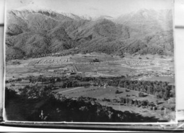
This photo is of the very newly constructed State Electricity Commission town of Mt. Beauty. The houses up to Nelse street were erected from 1946 onward and then the township was extended beyond Nelse Street in 1950 which places this photograph about 1950/51. There is no evidence of work being commenced on the regulating pondage but the tail race canal can be seen on the centre right of photo. The workmen's camp was enlarged in 1950 to the extent of providing accommodation for a total of 1,200. There are a number of dwellings on Simmonds Creek and the road to Falls Creek can clearly be seen. Snow capped Mt. Bogong is in the upper left of the photo with Mt. Beauty behind the township rising to Big Hill beyond that.Shows the newly constructed town of Mt. Beauty surrounded by farmland and before the regulating pondage was built to discharge water from the power stations via the West Kiewa tail race tunnel into the Kiewa River. Copy of black and white photograph of Mt Beauty CampWritten on the back in black ink - A Campenmt beauty camp, secv, construction town -
 Kiewa Valley Historical Society
Photograph – Photocopy of black and white photograph of Bogong Creek Race Line. 17/1/51, 17/01/1951
A start on the construction of Bogong Creek race line was made at the commencement of winter in 1948. Work proceeded in the following years when work on the High Plains was not practicable. In January, 1951 the special trimming machine, the special slip form and concrete mixing and placing equipment was put into service. A shortage of cement caused some delays as well as a sudden financial recession. The race line was completed and put into service in 1952.An historical record showing the machinery used during this time, the number of workers and supervisors involved and the mountainous terrain where they worked. It also demonstrates the OH&S of the period with workers mostly in street clothing with no hard hats or other safety equipment. Several workers can be seen working shirtless or in singlets.Photocopy of a black and white SECV photograph No: K 6209 labelled Bogong Creek Race Line ch. 1700. Depicting large group of workers and supervisors working at the site. Dated 17/1/52Printed underneath the photograph: STATE ELECTRICITY COMMISSION OF VICTORIA Date: 17/1/51 Time: 10.30am No: K 6209 Kiewa Hydro-Electric Works Bogong Creek Race Line ch. 1700 bogong creek raceline; secv; kiewa hydro electric scheme; -
 Kiewa Valley Historical Society
Photographs – Set of 13 colour photographs of spectators preparing for the street parade to celebrate the first Official Hoppet race run at Falls Creek in 1991, 1991
In 1977 a group of Mount Beauty cross country skiers formed the Birkebeiner Nordic Ski Club. In 1979, a version of the famous Birkebeiner race, the first Australian Birkebeiner was held at Falls Creek. In June 1990 representatives from Australia put their case for a southern hemisphere race in the series. Following a trial event in 1990. Australia became the 12th member of Worldloppet in the winter of 1991, with the first Kangaroo Hoppet. In 1991 a parade and commemorative torch lighting ceremony were organised in Mt Beauty as part of the celebrations to mark the first official Kangaroo Hoppett with participation from local community groups and commercial organisations, the Chamber of Commerce, local government representatives and individuals.Kangaroo Hoppet caters to diverse interests by offering a 42km and 21km event. It also offers a 7km event that attracts skiers, ranging from elite juniors to parents, grandparents, babies and first time skiers. It is recognised on the world cross country ski race calendar. It brings large numbers of participants and spectators to the area which support tourism, local businesses and employment. The 2018 event will be the 28th Kangaroo Hoppet, with cross country skiers travelling from across the country and overseas to compete.Set of 13 colour photographs of spectators lining both sides of Holland St in preparation for the Kangaroo Hoppet street parade. Photographs show the original hospital buildings and street-scape of the early 1990’sNo markingskangaroo hoppet; cross country skiing; ski race; bogong high plains, mt beauty, parade -
 Kiewa Valley Historical Society
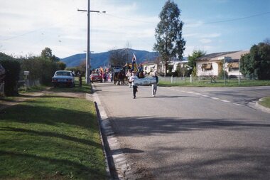
Photographs – Set of 25 colour photographs of the street parade to celebrate the first Official Hoppet race run at Falls Creek in 1991, 1991
In 1977 a group of Mount Beauty cross country skiers formed the Birkebeiner Nordic Ski Club. In 1979, a version of the famous Birkebeiner race, the first Australian Birkebeiner was held at Falls Creek. In June 1990 representatives from Australia put their case for a southern hemisphere race in the series. Following a trial event in 1990. Australia became the 12th member of Worldloppet in the winter of 1991, with the first Kangaroo Hoppet. In 1991 a parade and commemorative torch lighting ceremony were organised in Mt Beauty as part of the celebrations to mark the first official Kangaroo Hoppett with participation from local community groups and commercial organisations, the Chamber of Commerce, local government representatives and individuals.Kangaroo Hoppet caters to diverse interests by offering a 42km and 21km event. It also offers a 7km event that attracts skiers, ranging from elite juniors to parents, grandparents, babies and first time skiers. It is recognised on the world cross country ski race calendar. It brings large numbers of participants and spectators to the area which support tourism, local businesses and employment. The 2018 event will be the 28th Kangaroo Hoppet, with cross country skiers travelling from across the country and overseas to compete.PHYSICAL: Set of 22 colour photographs of the street parade to celebrate the first Official Hoppet race run at Falls Creek in 1991. Participants from a range of local community groups are traveling along Kiewa Cres. Photos are taken near the corner of Maddison St 1&2 – Horseman & accordion player leading the parade Sign reads ‘Falls Creek The Happy Mountain’ 3-4 Birkbeioner Nordic Ski Club with Chinese Nordic ski representatives 5 & 6- Girl Guides & Brownies 7, 8 & 9- Mt Beauty Primary School & Netball team 10 & 11- UKV Calisthenics Club 12- Lawn Bowls Club 13- Junior Football Club 14- Mt Beauty High School Band (on Wodonga Timber & Hardware truck) 15, 16 17 & 18- Mt Beauty Kindergarten 19,20, 21 & 22- Local Community Vehicles including Community Transport and Fire Brigade 23 & 24- Mt Beauty High School Band 25- Fiat 500 Topolino Vintage Car No markingskangaroo hoppet; cross country skiing; ski race; bogong high plains, mt beauty, parade -
 Kiewa Valley Historical Society
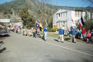
Photographs – Set of 13 colour photographs of the street parade to celebrate the first Official Hoppet race run at Falls Creek in 1991, 1991
In 1977 a group of Mount Beauty cross country skiers formed the Birkebeiner Nordic Ski Club. In 1979, a version of the famous Birkebeiner race, the first Australian Birkebeiner was held at Falls Creek. In June 1990 representatives from Australia put their case for a southern hemisphere race in the series. Following a trial event in 1990. Australia became the 12th member of Worldloppet in the winter of 1991, with the first Kangaroo Hoppet. In 1991 a parade and commemorative torch lighting ceremony were organised in Mt Beauty as part of the celebrations to mark the first official Kangaroo Hoppett with participation from local community groups and commercial organisations, the Chamber of Commerce, local government representatives and individuals.Kangaroo Hoppet caters to diverse interests by offering a 42km and 21km event. It also offers a 7km event that attracts skiers, ranging from elite juniors to parents, grandparents, babies and first time skiers. It is recognised on the world cross country ski race calendar. It brings large numbers of participants and spectators to the area which support tourism, local businesses and employment. The 2018 event will be the 28th Kangaroo Hoppet, with cross country skiers travelling from across the country and overseas to compete.Set of 13 colour photographs of the street parade to celebrate the first Official Hoppet race run at Falls Creek in 1991. Participants were from a range of local community groups and local industry representatives. Photos were taken on Holland St. opposite the old hospital building. Following the parade, a market stalls were set up on the green outside the Community Centre on Holland St. as part of the Hoppet celebrations. 1 & 2- Boy Scouts and Cubs 3- UKV Lions Club 4 & 5- Local children representing the history and fauna of the High Plains 6- Ambulance Services 7, 8, 9 & 10 – Representatives and equipment from local forestry industry 11- Vintage truck by Vintage Charms Tours providing tours of the local area for visitors 12 & 13- Market stalls set up on the green outside the Community Centre on Holland St. as part of the Hoppet celebrations. kangaroo hoppet; ski race; cross country skiing; bogong high plains, mt beauty, parade, -
 Warrnambool and District Historical Society Inc.
Map, Plans (5) showing Subdivisions of Warrnambool, 1989
These plans have been drawn by Steve Hester for the Warrnambool City Council to illustrate the allotments in Warrnambool concerned with the subdivisions of 1989. The streets have not been named but there is an indication of the area with the identification of known buildings (eg Hospital) and the plan numbers of each allotment is clearly marked. These numbers corresponded to the plan numbers registered in card files and ledgers in the Warrnambool City Council offices. The scale of the plans was 1 to 5000. These plans are of considerable interest because they show Warrnambool street subdivisions of 1989 in illustrative form. They show how information was collated in the late 1980s before the widespread use of computer digital means to describe and store information.These are five hand-drawn sheets showing plans of sub-divisions in Warrnambool streets in 1989 (Warrnambool City Council material). The plans are multi-coloured (crayons) and show allotments with plan numbers. The first plan has much of the material torn off but the location is known to be in the Russells Creek area. Some of the green tape around the edges is missing. Plans two to five are almost intact and are bound with green tape. Plan Two- Industrial Estate of West Warrnambool; Plan Three – Hospital/Merrivale/ Lake Pertobe areas; Plan Four – North Warrnambool, Wollaston/Brierly areas; Plan Five – Flaxman Street area. ‘Subdivision Plan, Reference Guide, Steve Hester, Oct. 1989’. warrnambool street subdivisions, steve hester, history -
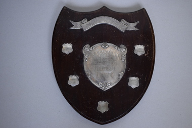 Warrnambool and District Historical Society Inc.
Shield, 1947
This trophy has been presented to the Warrnambool & District Football League by the South Warrnambool Football Club. This latter club still plays in the Hampden Football League and dates back to the 1880s and possibly beyond and has always been a traditional rival of the Warrnambool Football Club. West End Football Club dates back to the 1890s and joined with the Allansford Football Club in the 1960s to form the West End Allansford team. In 2001 the name ‘West End’ was dropped from the club’s name. Russells Creek Football Club was established in 1931 and still plays in the Warrnambool & District Football League which dates back to the early 1900sThis football trophy is of interest as it comes from the mid 20th century and concerns two local Warrnambool football clubs still existing today and one club that no longer exists.This is a wooden trophy in the shape of a shield. It has a silver scroll on the top and a silver heart shape in the middle. There is a cord on the back of the shield attached by metal hooks for hanging purposes. There are five small shields with etched writing on four of these. The shield is a little scratched. ‘South Warrnambool Football Club Shield’ ‘Warrnambool & District Football League’ ‘R.C.F.C. Premiers 1947 Tom Zanos (Captain) H. Drewitt (Coach)’ ‘W.E.F.C. Premiers 1948 P. Lake Capt. & Coach G.R.Thomas Pres.’ ‘W.E.F.C. Premiers 1949 W.L. ‘Jack’ McMurrick Capt. & Coach’ ‘West End F.C. Premiers 1950 W.L. McMurrick Capt. & Coach’ south warrnambool football club, warrnambool & district football league -
 Warrnambool and District Historical Society Inc.
Map, Department of Lands and Survey (Lithographers), Caramut township, 1938
This map of the township of Caramut was produced in 1938 but shows the original land owners of each town allotment and of the surrounding area. The size of all the allotments and the date of the original purchase are also shown. Caramut is a Victorian Western District town on Mustons Creek on the Hamilton Highway 48 kilometres from Warrnambool. This map was used by Rolf Crawley when he was the engineer for the Shire of Warrnambool from 1935 to 1968. The annotations on the map have probably been made by Rolf Crawley as they refer to the records and letter books of his father, John William Crawley, Junior (Shire of Warrnambool Engineer 1895 to 1935). Both Rolf Crawley and his father, John had private businesses as architects, surveyors and engineers and the map could have been used in connection with both their official Shire duties and their private businesses. The last owner of the map was the surveyor, Michael Hand who took over the business of Rolf Crawley in the late 1960s. This map is of great interest firstly because it has all the historical details of the land first purchased in the town of Caramut and area and secondly because it came from the office of Rolf Crawley, the engineer for the Shire of Warrnambool from 1935 to 1968. This is a buff-coloured paper map with a cloth backing. The map details are in black and white print. There are some handwritten red and black annotations on the map. “Town of Caramut Parish of Caramut County of Villiers’town of caramut, john william crawley junior, warrnambool, rolf crawley, warrnambool