Showing 1102 items
matching information map
-
 Kiewa Valley Historical Society
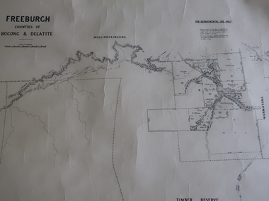
Map - Freeburgh - Counties of Bogong and Delatite
Drawn and reproduced at the Dept. of Lands and Survey, Melbourne, Victoria November 1948Black and white map of Freeburgh, County of Bogong and Delatitefreeburgh, map county of bogong and delatite -
 Kiewa Valley Historical Society
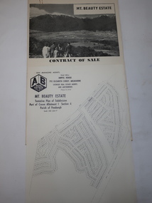
Folder - Mt Beauty Estate
After the State Electricity of Victoria completed the construction of the Kiewa Hydro Electric Scheme in 1961 the township of Mt Beauty was sold. The Shire of Bright (currently Alpine Shire) purchased the town and individual houses were put up for sale to the public.The sale of Mt Beauty changed the town - its occupants, its industry, its governance etc. Papers held in a manila folder. They include the Contract of Sale and Maps of Mt Beauty 1961mt beauty township, shire of bright -
 Kiewa Valley Historical Society
Papers - Geological Survey, Reports of Fossil Specimens, Maps
Research undertaken in the local areaStudy done by resident of the Kiewa ValleyPapers photocopied from books pertaining to the local areageology, fossils -
 Kiewa Valley Historical Society
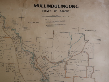
Parish Map - Mullindolingong, County of Bogong
The Department of Lands regularly updated the occupiers with leases or licences of the land.The names of the early settlers of the Kiewa Valley occupying land by lease or licence are shown. Many of these familie's descendants still live in the Kiewa Valley.Government (Lands Department?) cloth map showing the leases or licenses of occupiers of the land in the valley. The Kiewa River is shown in blue and roads in yellow. There is no date on the map.parish of mullindolingong map, settlers of the kiewa valley -
 Kiewa Valley Historical Society
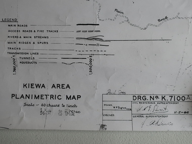
Map - Kiewa Area Planimetric Map
Planimetric maps are two-dimensional representations of the Earth's surface, showing the location and spatial arrangement of features such as roads, buildings, and bodies of water.A very clear map showing the Kiewa Hydro Electric Scheme in two dimensions to include the construction done by the SECV.Black and white Map of the Kiewa Area from Mt Beauty to the High Plains covering the Kiewa Hydro Electric Scheme and surrounds. Drawn on 11th May 1966kiewa hydro electric scheme 1966 -
 Kiewa Valley Historical Society
Map of the Ovens and Murray District of Victoria
The map features Beechworth and its history.This map features the north-east and in particular, Beechworth where residents of the Kiewa Valley may have shopped or visited for appointments.Black and white map with references to roads and gold. The centre of the map is Beechworth and in the bottom left side of the map is the heading Beechworth with 12 lines of print of information regarding Beechworth. The Kiewa Valley is not identified.beechworth -
 Kiewa Valley Historical Society
Maps - Kiewa Valley Parish Maps x3 and Kiewa Area Planimetric Map x1
Planimetric maps are 2 dimensional representations of the Earth's surface, showing the location and spatial arrangement of features such as roads, buildings, and bodies of water. The parish maps show the occupiers with leases or licences of the land. These are updated by the Department of Lands regularly. The names of early settlers of the Kiewa Valley occupying land by lease or licence are shown. Many of these familie's descendants still live in the Kiewa Valley.1. Kiewa Area Planimetric Map (photo) 2. Wermatong, County of Bogong Parish Map 3. Mulllindolingong, County of Bogong Parish Map 4. Mullagong, County of Bogong Parish Map All black and white kiewa valley. parish maps. land owners -
 Kiewa Valley Historical Society
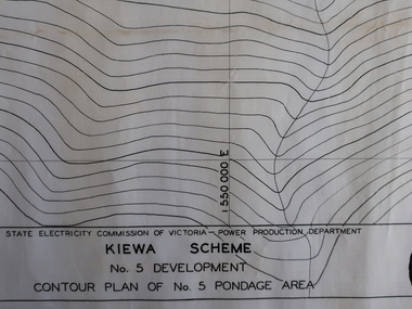
Plans - Kiewa Works Area and Environs
State Electricity Commission of Victoria constructed the Kiewa Hydro Electric Scheme from the late 1940s to 1961. These plans were used during the construction.Plans and Maps were used during the construction of the Kiewa Hydro Electric SchemeTransparent with blue tinge plans/maps created by the SECV during the construction of the Kiewa Hydro Electric Scheme. 1. Kiewa Scheme No 5 Development Contour Plan of No 5 Pondage Area 2. Mt Beauty Township 3. Kiewa Scheme No 1 Development - McKay Creek Area, Construction Layout 4. Kiewa Works and Environs 5. North Eastern Victoria and Adjoining Snowy Mountains Regionsecv, kiewa hydro electric scheme plans -
 Kiewa Valley Historical Society
Maps 3D - National Parks
Used by the employees of National Parks. The maps show the topography and contours in 3D when used with the stereoscope KVHS 0743. This enables the photographed area to be compared to previous photos and enables the planning of construction of eg. new roads etc. Digital information is now available.These photographs give the topography and contours of vast local areas eg. Mt Feathertop and Tawonga township.when used with a stereoscope. Black and white large aerial photos of the Bogong High Plains area. 14 to 20 of them all on thick paper and the same size as the brown wooden box which holds them. The box hasn't got a lid at the top.Identified and catalogued by National Parksmaps showing topography, national parks, stereoscope -
 Kiewa Valley Historical Society
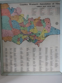
Framed Map - CWA- Tawonga
CWA of Victoria was a popular widely known organisation throughout Australia. The CWA aimed to improve health welfare, and education for women and children living in the country.Each town / area in the Kiewa Valley had an active CWA. The Tawonga branch commenced in Feb. 1946 and often combined activities with other branches of the Kiewa Valley.Country Women's Association of Victoria Group Map, June 1961. each area is colored ad each wit a letter of the alphabet. each group has a number and is listed. eg. blue, 'N' and "Tawonga 14' country women's association, map of cwa groups, tawonga cwa -
 Kiewa Valley Historical Society
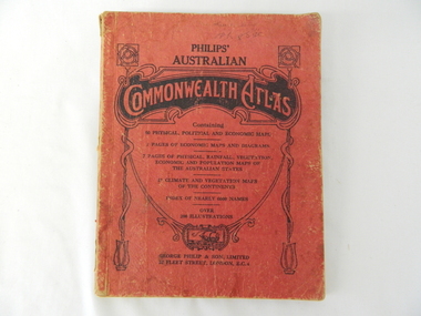
Atlas Australian Commonwealth, Philips' Australian Commonwealth Atlas, 1944
This atlas, printed in 1944, details not only the geographic and political boundaries of the world as it was at that time but also the snap shot of life of the time. This snap shot in time covers the major Australian cities, the major farming, grazing, industrial and sporting/recreational activities. Also there are snap shots of similar activities from other global areas. The period also covered World War II, detailed by a photo of "shell making", munitions, required by Australian soldiers. The great political and territorial changes made as a result of World War II can be clearly identified for example , Israel (the Jewish homeland). The various prewar colonies of major European nations.This atlas was used by children of a Kiewa Valley family and shows the value and the general educational exposure that these children had at this time. The rural setting and within the backdrop of a world war did not severely alter the life style of children in this region. The "news reels" shown in cinemas of cities and larger towns were the only visual realisations of major events of global significance available to these children. The information provided by this atlas allowed students to glimpse at what the "outside world" was. The majority of these students would possibly never see these regions for themselves. The great communication facilities of the late 1900s and beyond, was still only science fiction.This atlas has a thick (350 g/m) red cardboard cover with bold black lettering and shading. The cover is set out within a shield like frame. The shield is held up by two square markings, each with a four part circular pattern and a cord entwining two pendulum structures ending with a bowl figure at the bottom. There is a semi circular form enclosing a printed book contents list. The inside cover has the atlas title and contents and the publisher details. The atlas contain 56 pages of world and Australian maps, vegetation and rainfall maps. Within this atlas there are 27 double sided pages of black and white photographs depicting life styles, buildings, landscapes and prominent and significant to Australia males from 1652 to 1944. The pages are of approximately 200 g/m and have the yellow aged appearance.On front cover "Philips' Australian COMMONWEALTH ATLAS" and underneath "Containing" underneath "60 PHYSICAL, POLITICAL AND ECONOMIC MAPS". Publisher George Philip & Son, Limited 32 Fleet Street, London E.C. 4. Inside cover are: written, in freehand and in ink the following names and dates; "J.Muller Form V 1945", "L L Muller Form IV 1946", "N.J. Muller Form I + II + III 1948 +49 + 50" and "D Muller Form I 1949". also handwritten and in pencil is "Peter Leslie". On the last page is a small freehand sketch of Australia in biro.1940s school curriculum, rural education, 1940s atlas, australian atlas -
 Eltham District Historical Society Inc
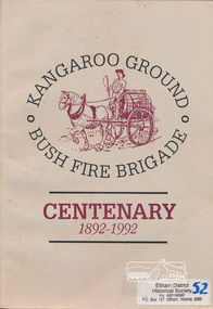
Book, Bruce Bence, Kangaroo Ground Bush Fire Brigade, centenary 1892-1992 : the story of the Kangaroo Ground Fire Brigade / Bruce Bence, 1992
Contents (described as Index): The early days, Ewen Hugh Cameron, 1914-1939, Supporting organisations, Eltham Emergency Operations Centre, Kangaroo Ground Fire Brigade Ladies Auxiliary, The fire tower, the Salvation Army and Red Cross, 1930-1992, The Kangaroo Ground Fire Brigade Today, Kangaroo Ground Fire Brigade Chronology. Includes a list of names of office bearers. Also includes references to neighbouring brigades and copies of historical newspaper articles. This publication was supported by the resources, information and facilities of The Shire of Eltham Historical Society.This book is significant in that not only does it traces the development of Kangaroo Ground Bush fire brigade since 1892 and of emergency services in the area but it also gives an insight into the people and their community.Softcover; 61 p., [7] p. of plates : b&w ill., 7 maps, ports.ISBN 064606651Xkangaroo ground, fire brigades, emeregency services, kangaroo ground fire brigade, fires, bush fires, shire of eltham war memorial, kangaroo ground tower -
 Eltham District Historical Society Inc
Book, Melway Great Melbourne street directory including Geelong, Phillip Island Healesville, Bellarine & Mornington Peninsulas, 1998
25th edition. Coloured detailed maps accessed by a street or location index. Cover: (Includes) New Southbank map including Crown Complex, enlargements of Footscray and Kensington, bike paths, walking tracks & horse trails, latest public transport information, South east Australia tours maps, Vic Roads new route numbers, map of Australia1 atlas (22, 772 p.) : col. maps ; ISSN 03113957streets, maps, roads, melbourne -
 Eltham District Historical Society Inc
Book, Melway Publishing, Melway Greater Melbourne street directory : including Geelong, Phillip Island, Healesville, Bellarine & Mornington Peninsulas, 2002
Edition 29. Coloured detailed maps accessed by a street or location index. Cover: 20 additional pages of new maps, extended coverage of Bellarine Peninsula, further coverage of Werribee South, Public Transport Information, latest official suburb boundaries, CBD "hook turn" intersections map, over 1200 new streets, 1 atlas (24, 886 p.) : col. maps ; ISSN 03113957streets, roads, melbourne, maps, melway -
 Eltham District Historical Society Inc
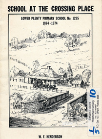
Book, School at the crossing place : Lower Plenty Primary School no. 1295, 1874-1974 / W.F. Henderson, 1974c
23 pages including information on inside covers. Text with black and white illustrations and photographs and map. Contents: Crossing Place Need for a school Residence for the teacher Closure A View of Lower Plenty 1918 Moving day at the Village The Golf Club Depression 1931 Vandals Electricity Grass Fires Cows at School Mothers' Club Women's liberation 1950's Lower Plenty after 1945 Swimming Pool - drowned dreams Long Grass - snakes - meadow hay - Fire Brigade The Royal Visit 1954 School Band Community Centre Our School Hall Trees and Gardens The Library Education 1874-1974 A Teacher's View The Second generation - children of ex-pupils (photo with names) The Third generation - Grandchildren of ex-pupils (photo with names) Head Teachers (list with dates) The Staff 1974 (photo with names) The sketch on the cover shows the Lower Plenty Bridge, toll house and the Plenty Bridge hotel, both no longer there. The bridge is listed in the Banyule Heritage Study and has recently been restored by Banyule Council as a pedestrian bridge - NL 137 March 2001 Paperback; [24] p. : ill. ; 25 cm.lower plenty, state school no. 1295, lower plenty primary school -
 Warrnambool and District Historical Society Inc.
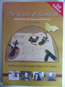
Book, Streets of Hamilton, 2007 (revised and reprinted 2009)
This is a book providing information on the streets of Hamilton, Victoria and the origin of the names. Hamilton is a city in Western Victoria at the intersection of the Glenelg Highway and the Henty Highway. European settlement began with the arrival of pastoralists following the 1836 explorations of Major Thomas Mitchell. The Wedge family in 1839 had the property ‘The Grange’ which covered the site of Hamilton today. The town was gazetted in 1851 and named after a place in Scotland. Hamilton Victoria is the centre of a sheep-grazing and agricultural district. The book won an award in the 2008 Victorian Community History Awards. This book is of interest as it gives information on the Hamilton streets and the origin of their names. The history of Hamilton is of particular interest to those also living in the Western District. The book will be a useful research tool. This is a soft cover book of 174 pages. The back cover has a white background with black and white photographs of five local Hamilton people. The front cover has a yellow and brown background with black and white photographs of five local Hamilton people, an outline of a map of Victoria and a photograph of a map of the Hamilton area with some artefacts placed on the map. The book contains an Introduction, a Preface, a Foreword, an Early Days Overview, a list of Contents, a list of the streets in alphabetical order with information on the origin of the names, two Appendices and an Index. The book has many black and white photographs and sketches. Front Cover: ‘2nd Edition’ ‘The Streets of Hamilton’ ‘Western Victoria Australia’ ‘By John McKay’ ‘A History of the People behind the Names’hamilton, victoria, john mckay, street names of hamilton, warrnambool -
 Warrnambool and District Historical Society Inc.
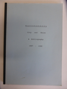
Booklet, City & Shire Bibliography 1847-1988, 1989
This 1989 booklet contains lists of publications connected with Warrnambool and District and it was compiled by W. Pinson and M. Johnstone. The publications listed were ones held at the time by the Warrnambool branch of the Corangamite Regional Library Service and the Warrnambool Institute of Advanced Education library. The publications are listed under the headings of Community, Environment, Heritage, Industry and Tourism. Although the information in this book is well out-of-date, it may be of interest to researchers today. The publications may still be available at the Warrnambool Library or at the South West College of TAFE in Timor Street Warrnambool or at Deakin University in Warrnambool. This is a soft cover booklet of 162 pages. It has a pale blue cover and is bound with black tape. It has a map of Warrnambool city, an Introduction, an alphabetical listing of publications concerning Warrnambool City and Shire and an Index. It has some photocopied black and white photographs of Warrnambool (untitled) and a reproduction of the front cover of Osburne’s History of Warrnambool.Front Cover: ‘Warrnambool City and Shire’ ‘A Bibliography 1847-1988’ history of warrnambool, history of western district, warrnambool library -
 Warrnambool and District Historical Society Inc.
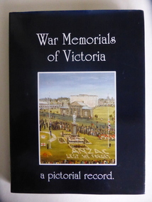
Book, War Memorials of Victoria, 1994
This book gives information on 1,100 War Memorials in Victoria. It was compiled by Bradley, Christey et al and produced for the Returned and Services League of Victoria. War Memorials were established in most settlements in Australia after World War One and added to after World War Two and succeeding conflicts. The number of War Memorials reflect the historical importance of Australia’s involvement in world wars and because of our distance from the battlefields they have become sacred places in Australia – de facto war cemeteries. The book includes information on the Warrnambool War Memorial and those in our area. This book is of interest as it gives details on War Memorials and includes all those in the Western District of Victoria. It will be useful to researchers of social and military history. This is a hard cover book with a blue cover and gold printing on the spine. The dust cover is dark blue with a colour sketch of the Portland War Memorial and white printing on the front cover and an outline of the map of Australia on the back cover. The book has 240 pages, black and white and colour illustrations, a Foreword, Dedication, Acknowledgements, Introduction, Contents, Bibliography and Index and information in alphabetical order of the War Memorials in Victoria. It also has reproductions of 20 oil paintings of Victorian War Memorials by Dacre Smyth.Spine: ‘War Memorials of Victoria’ R.S.L. Victorian Branch’ Front Cover: ‘War Memorials of Victoria, a Pictorial Record’ war memorials in victoria, warrnambool war memorial, history of warrnambool -
 Warrnambool and District Historical Society Inc.
Map - An Angler's map of the Hopkins River Estuary, Angler's map Hopkins River, 1980s
This is a map of the Hopkins River Estuary prepared by Dr John Sherwood for the benefit of anglers. The information on the sheet includes the location of sand banks, the water depths, boat ramp facilities and public access facilities. Some of the information has been gathered from aerial photographs. The map has been produced by the Warrnambool Institute of Advanced Education which was developed in the late 1960s from the tertiary section of the Warrnambool Technical College and with all its departments established by 1984 at the Sherwood Campus five kilometres from Warrnambool on the Princes Highway. Today the site is occupied by Deakin University, Warrnambool campus. The Warrnambool Anglers’ Club has its headquarters on the banks of the Hopkins River near the mouth of the river and the Lyndoch Aged Care facility.This map is of interest as a specialist one, providing fishermen with detailed information on all aspects of the Hopkins river estuary. Fishing has been both a profession and a popular recreational pursuit for Warrnambool residents since the early days of the city’s settlement. The Hopkins River Estuary has been a focal point for fishermen throughout Warrnambool’s history. This is a sheet of paper folded three times to produce a folded map. The front cover has a black and white photograph of two fishermen with a large fish. The map of the Hopkins River Estuary is in yellow, blue and black and covers the side of one sheet and three quarters of the other side. There is an advertisement for the Hopkins River Boathouse with a black and white sketch of the boathouse and notes on the map written by Dr John Sherwood. There are several diagrams showing the water depths. The map has some silverfish damage and some tearing at the folds. warrnambool anglers’ club, history of warrnambool, hopkins river, hopkins river estuary, john sherwood -
 Warrnambool and District Historical Society Inc.
Booklet, Victorian Almanacs, 1860s
These Victorian Almanacs were published from 1859 to 1916. They contained information of interest to all Victorians, especially historians, businessmen, farmers and gardeners and must have sold many copies in Warrnambool, particularly before the local Warrnambool Standard Almanacs began publication in 1875. These booklets are of interest as examples of 19th century almanacs published in Victoria. They are also somewhat similar to the Almanacs published annually by the Warrnambool Standard newspaper from 1875 to 1930. The 1869 Almanac is of particular interest as it has on the front cover the printed name of James Hider, stationer and bookseller of Warrnambool. James Hider had been a carpenter, a land agent and a rate collector before opening a shop in Timor Street, selling books and stationery and operating a Circulating Library. In 1865 Hider set up as a photographer and was still operating this business in 1878. He was active in community organizations, including the Mechanics Institute, the Fire Brigade, the National School, the Musical Group and the Benevolent Society. He was also a Councillor and a Mayor in the 1860s. It is interesting to note that his name does not appear to have been been added to the 1869 Almanac cover but is part of the original printing. These are two soft cover booklets of 60 pages each. The back covers of both are missing and the 1868 booklet has some back pages missing. The 1868 Almanac has a black and white cover with ornamental scrolls and the 1869 booklet has a red, green black and cream cover with an ornamental border and images of flora and fauna. The 1869 Almanac cover has a Coat of Arms with Advance Australia printed at the bottom of it. The 1869 Almanac also has a map of Victoria as an insert. Both almanacs contain an historical calendar, Victorian Parliamentary information, data on Victorian cities, postal regulations, farmers’ and gardeners’ guides etc. Both contain advertisements relevant to Melbourne. Both have been bound with string. victorian almanacs, annual journals, james hider, bookseller and stationer,, warrnambool. -
 Warrnambool and District Historical Society Inc.
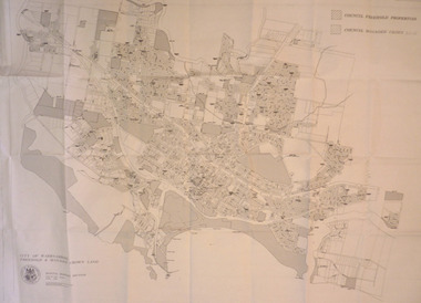
Map - City of Warrnambool Freehold and Managed Crown Land, City of Warrnambool Council, 14th April 1994
... information in map form of the Warrnambool land that is owned ...This map was drawn up by the City of Warrnambool Council staff to provide information on the land in Warrnambool that was owned or managed by the Council.This map is of considerable importance as it gives information in map form of the Warrnambool land that is owned (freehold) by the City of Warrnambool and the land that is managed Crown land. This is of interest to researchers and those seeking information on specific areas of land in Warrnambool.This map has digital mapping. The map has a white background with black and white mapping details of Warrnambool. It has the City of Warrnambool seal. Scale of map: 1:7500warrnambool city council, warrnambool -
 Warrnambool and District Historical Society Inc.
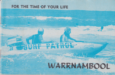
Booklet, For the time of your life Warrnambool, 1975
Tourist brochures have been produced in Warrnambool since the 1890s and this one has been published by the Warrnambool Chamber of Commerce and Industry. Some of the photographs for this brochure come from the Warrnambool Standard newspaper and the information on the car tours was provided by the Warrnambool Tourist Information Centre. Tourism in the Warrnambool region has always been of major importance to the town/city and a local Chamber of Commerce or Tourists’ Association has been active in the area for over 100 years. Today the official tourist guides are produced by the Warrnambool City Council. This brochure is a good example of local tourism promotion in the 1970s and will also be useful for display. This is a small booklet (1975) containing 39 pages. It has local Warrnambool advertisements, maps, photographs, printed material and details of 9 tours that tourists could take by car around Warrnambool. The pages are stapled. The front cover has a blue-tinged image of a surf boat patrol and the back cover has a black and white photograph of Warrnambool’s beach. There is one loose page with a summary of the tourist spots in Warrnambool and a map. Front Cover: ‘For the Time of Your Life – Warrnambool’.tourism in warrnambool, warrnambool -
 Warrnambool and District Historical Society Inc.
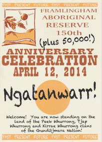
Booklet - 150 plus Framlingham Aboriginal Reserve, 2014
The Framlingham Aboriginal Trust is a shareholder- owned organization established under Victorian law in 1971. The Trust owns and manages part of what was the old Aboriginal Reserve established in 1861 under the auspices of the Church of England. In 1865 the Reserve was officially established as a Government-managed aboriginal station. By 1970 the original area of 3,500 acres was whittled down to 585 acres and handed over to the Framlingham Aboriginal Trust. Framlingham is today one of only two discrete aboriginal communities in Victoria where aborigines live on aboriginal land and is an important part of the district cultural life. The celebration of the 150th anniversary of Framlingham’s establishment in 2014 was therefore a significant event in the district’s history and the booklet is a permanent reminder of this.This is a small booklet of 8 pages containing information on the 150th celebrations of Framlingham Aboriginal Reserve in 2014. The cover has a cream background with illustrations and printed material in yellow, black and brown. The pages are stapled. The booklet includes photographs, maps, illustrations and printed material. Front cover: ‘Framlingham Aboriginal Reserve 150th Anniversary Celebration, April 12, 2014, Ngatanwarr’ etc Back cover: Acknowledgements of sponsors and written material framlingham aboriginal trust, western district aborigines, peek whurrong, kirrae whurrong, gunditjmara, tjap whurrong -
 Warrnambool and District Historical Society Inc.
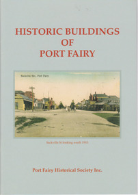
Booklet, Port Fairy Historical Society, Historic Buildings of Port Fairy, 2012
Port Fairy, a small town in Western Victoria established in 1836, has an exceptional collection of public buildings and dwellings dating from the 1840s. This booklet gives short descriptions of 58 of these historic buildings, many with accompanying photographs. These include many buildings in Gipps and Sackville Streets, the Powder Magazine, some hotels, the Drill Hall, Dublin House, the Port Fairy Cemetery and several schools and churches. This booklet is useful for those seeking quick information on the historic buildings in Port Fairy and for those wanting to undertake a walk around the town’s historic spots. TryBooking will show you the full breakdown on the Booking Payment Report and the Event Revenue Itemised Report so you can clearly see the ticket sales, credit card processing fee and the funds that are yours. Front cover: ‘Historic Buildings of Port Fairy, Port Fairy Historical Society Inc.’ Photograph on front cover: ‘Sackville Str. Port Fairy’, ‘Sackville St. looking south 1910’ Back cover map: ‘Port Fairy Historic Buildings’ warrnambool, port fairy, western victoria, historic buildings -
 Orbost & District Historical Society
book, Effingham, Wilson, A Geographical Dictionary of the Australian Colonies, 1848
A geographical dictionary or gazetteer of the Australian colonies : their physical and political geography : together with a brief notice of all the capitals, principal towns, and villages. William Wells travelled to Australia as a sponsored immigrant in 1838. Her became a freelance surveyor with an office in Bligh Street, Sydney. He wrote this book in order to better inform the British public on the colonies of Australia. The information contained in the book is both topographical and statistical and was a very useful refernece book at the time.This book is a rare detailed contemporary record of the Australian colonies in the mid 19th century.A hard back 453 pp book with a dark brown patterned cover which has a white label with the title, "Dictionary of Geography" over a map of Australia. It is illustrated with numerous maps and drawings.history-australia wells-william-henry geographical-dictionary-of-the-australian-colonies -
 Orbost & District Historical Society
book, History of New South Wales, 1889
George Burnett Barton (1836-1901), lawyer, journalist and historian, was born on 9 December 1836 in Sydney. He practised journalism rather than law for which he had qualified in 1860. This is Volume 1 and covers the proposals for colonising New South Wales, the transportation and the early years of Governor Phillip.This is a detailed history of New South Wales compiled from original records and is a very useful research tool.A hard cover 625 pp book with a dark brown cover. On the spine the text is gold. It is titled, "History of New South Wales from the Records, Volume 1". It contains illustrations, facsimiles, maps, portraits and detailed historic information.Vol 1 1783-1789 Bartonnew-south-wales-history convict-settlement phillip-arthur barton-george-burnett -
 Ringwood and District Historical Society
Map, Government Printer, Melbourne, Ringwood Zone Ordinance Survey Map, 1935
Ordinance survey map glued to cheesecloth, of Ringwood zone - Commonwealth topographical map dated 1.8.35, scale 1:63,360. Information correct up to June 1922. "Ringwood 81" printed on the reverse side.; Envelope and note from donor of item, with return letter of appreciation from Ringwood & District Historical Society dated 20-May-2005. +Additional Keywords: Reid, Don -
 Ringwood and District Historical Society
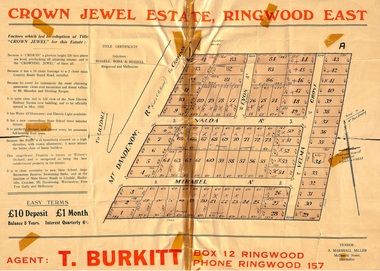
Memorabilia, History of "Jewel in the Crown" Estate, East Ringwood, Victoria, 1884-1947
Carter Real Estate Agents sold some of the subdivision in 1946-47. This information was tied in with the early orcharding families.Collection of notes, titles and maps of "Jewel in the Crown" subdivision - Mount Dandenong Road (formerly Oxford Road), Velma Grove, Valda Avenue, Mirabel Avenue. Genealogical charts of Meyland and Wigley families. 4 page history of the area compiled in 2004 by Richard Carter, Real Estate Agent. Registered Proprietors, Vendors, Property Title Holders and Transferees include: Herbert Edward WATSON, John Richard SHARP, Myrtle Evelyn BIRRELL, Marie Mathieson MUNRO, William Alex McCLELLAN, George Andrew GOODMAN, Joseph Tasman PEDRAZZI, Alexander ANDERSON, John Charles PATERSON, Eric William PHILLIPS, T.E.A. Co. Ltd., Florence Lavinia WYNARD, William John HARRIS, Lindsay and Hazel ALLNUTT, Douglas John RITCHIE, Eliza A.M. BOURBAND, Henrietta Irene COOK, Eric Edward COOK, Harold Thomas NICHOLLS, Stewart and Mary HIRD, Grace ROBINSON, Helen Rutherford GOOD, Henry Wyatt FARRELL, Irene Ann SMITH, Leslie Neil DOW, Helen Anne DOW, Frederick Ronald HOLDING, John Frederick McINTYRE, Horton Wilcox EDGE, Herbert James HARDINGHAM, Donald James ALLEN, Cyril Frederick WILLIAMS, Florence Sarah MAGGS, Maud Margaret PEARSON, Warwick Scott Holroyd MATTHEWS, Alice Eliza McCLEAVE, Leslie Archibald Charles HARRIS, Enid Beth HARRIS, Roy Victor DRAEGER, Elizabeth Ann STANDLEY, Charles Walter WATSON, Mabel Dorothy CARTER, Alan Garnett KELLY, Michael Vincent HARRIS, William Thomas Sylvester PROUD, Florence Blanche IVES, Douglas George PEARSON, Harry Clifford CLEGG, Dorothy Ellen Mary WHITE, Frederick Nathaniel EVANS, Madge EVANS, Leonard DUNSTAN, Violet Florence CONNELL, Valerie Jean Schimmelbusch, John Sydney COOK, William Donald THOMPSON, Ralph E RAUNSLEY, Murray McRae OSBORN, Francis William CLARKE, Alfred Daniel WILLIAMS, Harry Clifford CLEGG, Bernard Francis GARRY, Richard McKENZIE, Mignor Leonie WESTON, Idonea Moncrieffe DAVIS, Helen Marsden Rutherford GOOD, George SMART, Clement Henry DAVIS, Peter FINLAYSON, Elenor Leah HARVIE, Charles MEYLAND. -
 Cheese World Museum
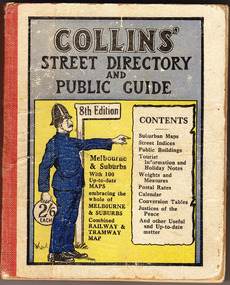
Book, Queen City Printers Pty Ltd, Collins Street Directoryand Publice Guide: 8th Edition
... directory public guide Collins Melbourne maps tourist information ...The Percy Uebergang family lived at Tooram Park, Allansford from 1912 until 1992. This booklet was part of the collection of items given into the care of the Cheese World Museum. Uebergang catalogue No. -not listed White hard cover pocket-sized street directory book with red cloth spine. The front cover has a blue and yellow background with title, contents, edition listed and a policeman in a blue uniform. The back cover has information in black print. Melbourne and suburbs maps throughout. 439 pages.COLLINS' STREET DIRECTORY/AND/PUBLIC GUIDE/8th Edition/2/6 each/CONTENTS/ Suburban Maps/Street Indices/Public Buildings/Tourist Information and Holiday Notes/Weights and Measures/Postal Rates/Calendar/Conversion Tables/Justices of the Peace/And other useful and up-to-date matterallansford, uebergang, street directory, public guide, collins, melbourne, maps, tourist information, queen city printers pty ltd, almanacs, local history -
 Australian National Surfing Museum
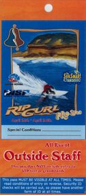
Surf Contest Pass, 2000 Bells Beach Competition Pass, 01/03/2000
This event access pass was issued to staff, vendors and community volunteers at the 2000 Rip Curl Pro at Bells Beach.The access pass is typical of the pass issued each year to the staff and workers at the longest running surfing contest in the world. The pass features unique Indigenous artwork by Torquay artist/surfer Glenn Romanis2000 Rip Curl Pro Access Pass. Full colour laminated access pass (Outside Staff) for the 2000 Rip Curl Pro and Sunsmart Classic. The pass features cover art by Indigenous artist Glenn Romanis and event management logos. The pass also features a site map on the back and access information.Event management logos on the front. Indigenous Bell artwork by Torquay artist/surfer Glenn Romanis.bells beach, rip curl, glenn romanis, surfing victoria, 2000 rip curl pro