Showing 3904 items
matching railway street
-
 Sunbury Family History and Heritage Society Inc.
Photograph
The photograph was taken when some work was being carried out on one of the arched railway bridges on the Sunbury line. The bridge spans the Jackson Creek and across the Rupertswood viaduct. The bridge over the Rupertswood Viaduct is one of the five significant bridges which span the railway line between Diggers Rest and Clarkfield.A black and white photograph of a bridge with scaffolding erected around the base of the arches.bridges, rupertswood viaduct, railway bridges -
 Sunbury Family History and Heritage Society Inc.
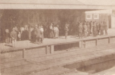
Photograph, c1920s
The crowd of people are waiting on Platform 1 at Sunbury Railway Station. A sepia photograph of a crowd standing on a station platform waiting for a train to arrive.sunbury railway station -
 Sunbury Family History and Heritage Society Inc.
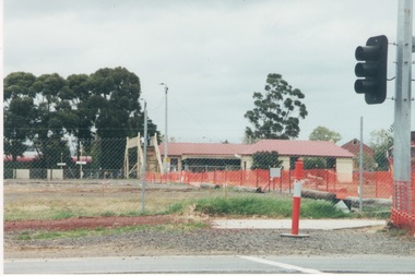
Photograph, c1999
The open are in the foreground was part of railway land on the west side of Sunbury Station along Horne Street. The initial preparations to develop the area into a commercial and entertainment precinct were just commencing. The development that took place on this site was indicative of the growth that was taking place in Sunbury in the early 2000sA coloured photograph of an open area feed off with temporary netting in preparation for construction work. A set of traffic lights are on the RHS of the photograph and a station is in the middle distance.sunbury railway station -
 Sunbury Family History and Heritage Society Inc.
Photograph, 2000
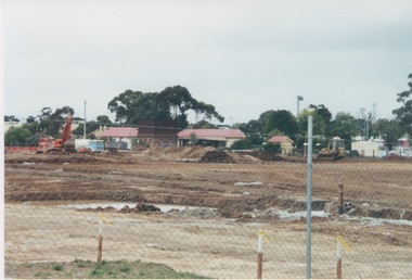
Excavation work to remove the grasslands and trees on the railway land on the west side of the Sunbury Station to make way for commercial development on that side of the line.A coloured photograph of excavation work in operation on land which has cyclone fencing around its perimeter. There are buildings in the middle distance beyond the work site.sunbury railway station -
 Sunbury Family History and Heritage Society Inc.
Photograph, 13 April 2000
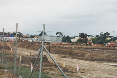
In 2000 work commenced on the further development of railway land on the west side of Sunbury station for the construction of commercial and entertainment facilities. Prior to this time the land had been undeveloped and was often used to accommodate visiting circus troupes. Cereal storage silos also occupied this area for some time. The development of this area has been a reflection of the rapid expansion of settlement within Sunbury and surrounding areas that occurred during the early years of the twentieth century.A coloured photograph of a fenced off area undergoing development with earthmoving equipment and trucks in operation and some commercial buildings visible in the middle distance.sunbury railway station -
 Sunbury Family History and Heritage Society Inc.
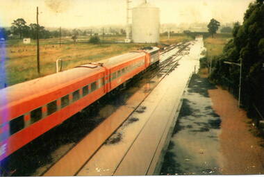
Photograph, 17 December 1985
On 17th December 1985 record torrential rain fell in Sunbury, which flooded the main Melbourne Bendigo rail line and disrupted traffic. The photograph is looking to the north of the station and takes in the historic Macedon Street bridge and the open ground with the storage silo on the west side of the railway line. A coloured photograph of a former V Line train stopped at a station where the railway line has been flooded. A storage silo occupies vac ant ground adjacent to the railway line.sunbury railway station, storage silos, horne street -
 Sunbury Family History and Heritage Society Inc.
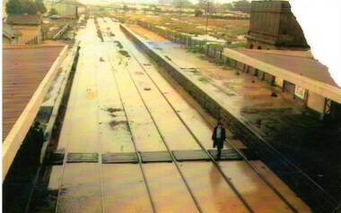
Photograph, 17th December 1985
On the afternoon of the 17th December 1985 torrential rain fell in Sunbury and surrounding areas which resulted in widespread flooding and caused disruption on the main Melbourne Bendigo Railway line. The photograph looking towards the south shows the extent of the flooding at Sunbury Station.A coloured photograph of a railway station and the flooded tracks.sunbury railway station -
 Sunbury Family History and Heritage Society Inc.
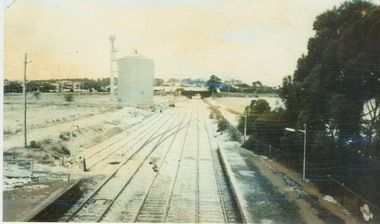
Photograph, 25th July 1986
Heavy snow fell across Melbourne and surrounding suburbs, including Sunbury, on 25th July 1985. The photograph taken from the pedestrian bridge at Sunbury Railway Station is looking north to the historic Macedon Street bridge. The widespread snow across the metropolitan area on that day caused much chaos.A coloured photograph of widespread snow across a railway line and the surrounding area.sunbury railway station, extreme weather events, snow storms -
 Sunbury Family History and Heritage Society Inc.
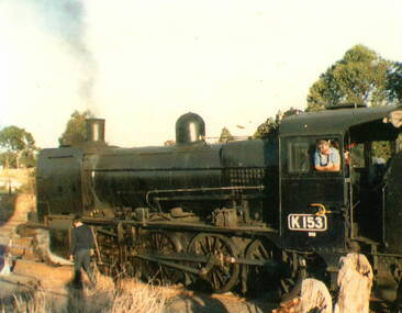
Photograph, c 1970s
The K class steam engines were often used on Victoria's regional rail lines taking passengers and goods across the state. A coloured photograph of a stationary steam train on railway tracks with the driver looking out his cabin window and a man walking alongside the train. steam engines -
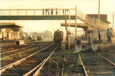 Sunbury Family History and Heritage Society Inc.
Photograph, c
The steam train has arrived at Number 2 platform at Sunbury Railway Station. Before diesel engines were used on the regional lines, steam trains were widely used. The pedestrian bridge spanning the railway line was replaced with a larger one to allow for disabled people's in 2001.A coloured photograph of a steam train arriving at a station with six people on the pedestrian bridge looking at the train and five other bystanders on the two platforms.steam locomotives -
 Sunbury Family History and Heritage Society Inc.
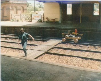
Photograph, c 1970
... Global Learning Centre Macedon Street Sunbury melbourne A railway ...A railway maintenance person is crossing the railway tracks from Platform 2 to Platform 1 at Sunbury Station. There is a partial view of the historic brick water tower, which was used by the steam engines, on Platform 2.A coloured photograph of a maintenance man walking across a railway track at a station.sunbury railway station, water towers -
 Sunbury Family History and Heritage Society Inc.
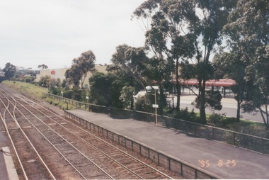
Photograph, 25th July 1995
The photograph of Sunbury Station was taken from the pedestrian bridge and is looking north to take in the Sunbury Square shopping centre buildings and the bus terminal which are on the Platform 1 or east side of the station.During the 1990s much development took place in Sunbury and the station precinct became a commercial hub.A coloured photograph of a railway station and a Coles Supermarket in the middle distance as well as a bus terminal. -
 Sunbury Family History and Heritage Society Inc.
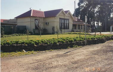
Photograph, 15th August 1995
The house was the former station master's residence. When the photograph was taken it served as a restaurant. In the late 1990s it was demolished to make way for larger commercial development.The former stationmaster's residence was one of the important buildings in Sunbury.A coloured photograph of a cream weatherboard house with light green trims surrounded by a garden. Four cars are parked outside the house.sunbury railway station, stationmaster's residence, brook street -
 Sunbury Family History and Heritage Society Inc.
Photograph, 15th
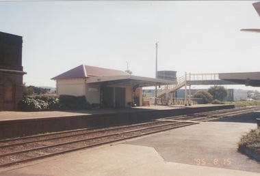
In 1993 Sunbury Railway Station underwent refurbishment and with some extensions added to the existing building. The Sunbury Garden Club undertook the task of constructing the garden on the east side of the station. The photograph was taken two tears after the completion of the work. A coloured photograph of a garden in front of a weatherboard railway station with a gravel pathway in the foreground.sunbury railway station -
 Sunbury Family History and Heritage Society Inc.
Photograph, 15th
The Number 2 platform at Sunbury Station is featured in this image along with the former wooden pedestrian bridge and partial view of the two water towers, which in the past were used to supply water for the steam engines. A coloured photograph of a platform at a railway station which includes a pedestrian bridge and metal water tower. sunbury railway station -
 Sunbury Family History and Heritage Society Inc.
Photograph, 25
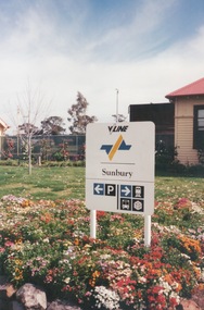
A coloured photograph of a V Line sign set in a flowerbed at Sunbury Railway Station. -
 Sunbury Family History and Heritage Society Inc.
Photograph, September 1996
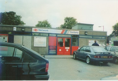
The photograph shows the railway station at Sunbury in Surrey in the United Kingdom. The town of Sunbury in Victoria was named after the English township of Sunbury-on-Thames in Middlesex by the Jackson Brothers who took up land in Sunbury, Victoria. The area was originally known as Koora Kooracup by the Wurundjeri people.Sunbury in Victoria like many other settlements in Australia were given names of towns in the United KingdomA coloured photograph of a railway station with three cars parked outside the building, which has grey walls and scarlet and blue trims. There are framed maps and notices on the exterior walls. -
 Sunbury Family History and Heritage Society Inc.
Photograph
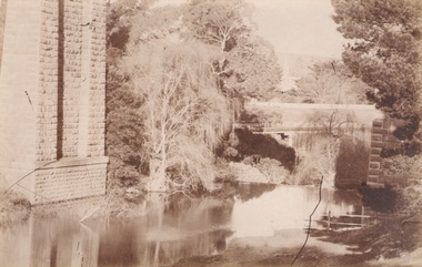
The photograph shows a section go the Jacksons Creek at Sunbury where it is spanned by the high arched Rupertswood railway bridge north of the town on the Bendigo line. The Melbourne to Bendigo rail line has a number of significant bridges along its route, five of which can be seen in Sunbury.A sepia photograph in post card format of a river flowing under a bridge. There is a partial view of the tall pylon on the LHS of the image.jacksons creek, bridges -
 Sunbury Family History and Heritage Society Inc.
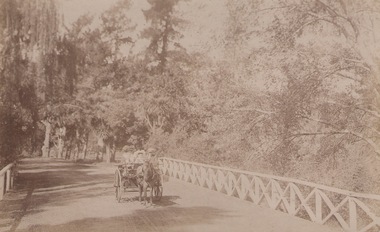
Photograph, c1900s
... Street and the other three are along the railway line. Macedon ...The people in the horse and cart are driving their vehicle over the original Macedon Road bridge which spans the Jacksons Creek in Sunbury. In the 1970s the road was diverted to take out the downhill bend at the approach to the bridge and a newer bridge was built close to the original one, which now takes pedestrian traffic.The original Macedon Street bridge is one of five heritage bridges in Sunbury. Two of them are built along Macedon Street and the other three are along the railway line.A sepia photograph in post card format of two people in a horse and cart going over a bridge with trees on each side of them.macedon street bridge, jacksons creek, sunbury -
 Sunbury Family History and Heritage Society Inc.
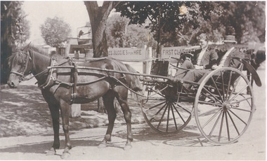
Photograph, c1900s
... The two men in the curricle were in Brook Street outside... Global Learning Centre Macedon Street Sunbury melbourne The two ...The two men in the curricle were in Brook Street outside Sunbury Railway Station.Before the advent of motor transport and buses, passengers from the train were taken by horse drawn vehicles to their destinations. An area was set aside at the station where the horses and vehicles waited for trains to arrive.A sepia photograph of two men seated in a stationary horse -drawn curricle beside a plantation area. There are two signs advertising horses and buggies for hire and some buildings are visible in the distance.curricles, brook street, sunbury, sunbury railway station -
 Sunbury Family History and Heritage Society Inc.
Photograph, 1936
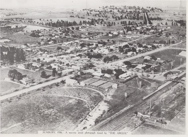
The aerial view of Sunbury was featured in The Argus newspaper in 1936 in recognition of 100 years of European settlement of the area. It shows the extent of the township in 1936 which extended from the railway line in the west to the Jackson Creek in the east and the Sunbury Asylum in the south and northwards towards Macedon Street. The photograph was taken when Sunbury was a country settlement 25 miles ( 37 kms) from Melbourne. Since the 1980s the area grown rapidly and is now an outer suburb of Melbourne.A black and white aerial photograph with a cream border of the Sunbury township. SUNBURY 1936 - A SOUVENIR AERIAL PHOTOGRAPH ISSUED BY THE ARGUS.aerial photographs -
 Stawell Historical Society Inc
Photograph, Railway Yards looking towards Wakeham Street c1960, approx 1965
Railway Yards Stawell looking towards Wakeham Street with water tank on left. c1960B/W Photgraph of Rail yards looking towards Wakeham Street. View shows water tank which was used in Steam engine days. house on left, Cnr. Sloane & Wakeham Streets No. 50 was adapted into two flats ( Possibly in the 190's. The weatherboard building on the right was the headquarters for the Stawell Homing Club ( Pigeon Club) Circa 1960's The Word Shell is visible on a train carriage.stawell railways transport -
 Stawell Historical Society Inc
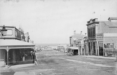
Photograph, Main Street Stawell looking West from Doyle Lane 1878
Main St. looking West from Doyle Lane. Playford on corner, Whiteside & Co Taylors, Carters Boot Shop. Railway train carriages in distance, Coffee Palace formerly Castlemaine Hotel in distance about centre of photo. Taken c. 1878. , From right of photo T. Brown & Co Timber & Iron Yard, T Brown's Furniture Warehouse, Cambrian Hall, Herbert,s Photographic Studio and Stawell Post Office.Victorian Views. C. Herbert, Photo. Stawell 1878stawell business streetscape -
 Stawell Historical Society Inc
Photograph, Railway Line Construction in Stawell area
Group of three photos from of men constructing railway cutting Wildcat Hill beside Napier Street. Norn Gray born Stawell 1911 and his father Robert worked on the cutting during the depression.stawell railways transport -
 Stawell Historical Society Inc
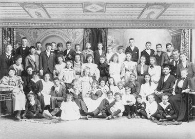
Photograph, Large Group at the Harvard College Stawell at 14 Ligar Street
Large Group at Harvard College Stawell (14 Ligar Street)Sepia photograph of a large group of about 50 students (and possibly teachers) at the Harvard College in Stawell. located at 14 Ligar St. Back row includes W.W. TELFORD , R.M.TELFORD and George BAXTER The school was named GLENARA from 1884 and operated as the Stawell Ladies College In 1882 it was renamed MARMION and was Stawell Girls High School and a kindergarten In Jan 1885 it was renamed HARVARD COLLEGEStawell Photographic Co. Close Railway Station C. HEWITT, Manager Harvard College Rear: WWT, ____, ____, ____ ____ RMT, Geo. Baxterstawell, telford, glenara, marmion, education -
Stawell Historical Society Inc
Archive - CD/DVD, Glenorchy Images (2) Glenorchy Historic Sites. Glenorchy, Footbridge, Four Posts Inn, Royal Mail Hotel, School, Street View, Wimmera River, Football Team, Railway Station, Cook& Sons Saddlers, Chas Lea Fruiterer, London Bank plus short histories, 2013/2014
stawell, glenorchy, streetscape -
Stawell Historical Society Inc
Archive - CD/DVD, Stawell Rail Photos - Various photographs of trains at Stawell, Stawell Station, Stawell Cutting, Stawell Turntable, Sloane Street Crossing, Goods Shed, Signal Box, Stawell Gift Special, Silo's, Grampians Line
stawell, transport, railways -
 Beechworth Honey Archive
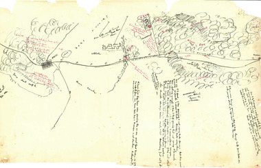
Hand-Drawn Map Centred on Ararat by Frank Lebbell Frost December 1916
This is one of the maps drawn by Frank L. Frost while he was beekeeping in North-East Victoria. This particular map may be reference in the "Wooden" Diary on page 11. Front Side: Hand-drawn map centred on Ararat, central Victoria. Details road and railway and vegetation with comments on flowering. Back Side: Comments in grey lead [ca 1923]hand drawn, hand-drawn, map, ararat, frost, beekeeper, beechworth honey -
Beechworth Honey Archive
Tax Stamp Sheets and Wages Records
Book of tax stamps sheets and wages paid by Aleck Hogg employee of L. A Frost & Sons of Railway St, Euroa. Book number 18882. For the year ending 1948.book, tax, stamps, wages, hogg, frost, beechworth honey -
Beechworth Honey Archive
Map- Everton
Map compiled from 1975 aerial photography. Printed in 1979.Map shows Everton, Ovens River, Beechworth- Wangaratta Rd, former Wangaratta- Bright railway. Scale 1:25,000. Printed colour on paper.Map labelled Everton. No. 8225-3-3.map, everton, ovens river, bright, railway, aerial, photography, paper, beechworth honey